|
REFINE
Browse All : Images of California and Southern California
1-13 of 13
Author
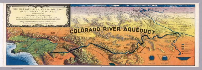
Metropolitan Water District of Southern California (Calif.)
Full Title
(Composite text) Water for thirteen cities in the Metropolitan Water District of Southern California : a brief description of the Colorado River Aqueduct, America's largest construction job in progress today. Issued by the Metropolitan Water District of Southern California. Second printing - August, 1935. Booklet prepared by Don J. Kinsey, Assistant to the General Manager, The Metropolitan Water District of Southern California. (with map) Metropolitan Water District of Southern California : Now building the Colorado River aqueduct. A Map of the Aqueduct Route ... Frank E. Weymouth.
List No
11917.004
Note
Informational brochure promoting the Colorado River aqueduct, extending across the entire state of California. with title page, 23 pages of text, black and white photos and a color pictorial fold out map of Colorado River aqueduct. Bound in pictorial mailing wrappers, illustrated with a photograph of Parker Dam, where aqueduct begins with mailing address on verso, with label "Water exhibit souvenir : California Pacific Exhibition, San Diego, California 1935. Bird's eye view map which folds out from the back cover shows how the Aqueduct will deliver water across mountain and desert country to each city in the Metropolitan Water District., pressure pipe line, tunnels, lined canals, member cities, etc. Includes 3 profiles showing Typical section grade tunnel; typical section grade conduit; Typical section lined canal. Relief shown pictorially. Includes legend.
Author
[Rheault, Jean-Louis, Carter, Paul, Mapformation]
Full Title
(Covers to) Native Son. Richard Nixon's Southern California. My Life on a Map! An illustrated map guide to the life and career of America's 37th President. Researched and written by Paul Carter. Illustrated by Pictorial Map Artist Jean-Louis Rheault.
List No
10460.001
Note
From the cover: "Researched and written by Paul Carter. Illustrated by Pictorial Map Artist Jean-Louis Rheault."
Author
[Rheault, Jean-Louis, Carter, Paul, Mapformation]
Full Title
Native Son. Richard Nixon's Southern California. My Life on a Map! An illustrated map guide to the life and career of America's 37th President. Researched and written by Paul Carter. Illustrated by Pictorial Map Artist Jean-Louis Rheault.
List No
10460.003
Note
From the cover: "Researched and written by Paul Carter. Illustrated by Pictorial Map Artist Jean-Louis Rheault."
Author
[Rheault, Jean-Louis, Carter, Paul, Mapformation]
Full Title
(Text page to to) Native Son. Richard Nixon's Southern California. My Life on a Map! An illustrated map guide to the life and career of America's 37th President. Researched and written by Paul Carter. Illustrated by Pictorial Map Artist Jean-Louis Rheault.
List No
10460.002
Note
From the cover: "Researched and written by Paul Carter. Illustrated by Pictorial Map Artist Jean-Louis Rheault."
Author
Blum, George W.
Full Title
(Untitled map of Southern California including Ventura, Los Angeles, San Bernardino, Orange, and San Diego Counties.)
List No
1592.007
Note
Bike paths shown in red and labeled with abbreviations. The first abbreviation of the two tells the road condition. Conditions are: G (good), F (fair), P (poor), and V.P. (very poor). The second abbreviation is for the grade of the road. Grades include: L (level), R (rolling), H (hilly), and M (mountainous).
Author
Willson & Co.
Full Title
(Covers to) Willson & Co.'s Indexed Sectional Map Of Southern California. Compiled And Published By Willson & Co., Map Publishers, 213 Powell St. San Francisco, Cal. Copyrighted 1895. Galloway Litho.Co. S.F.
List No
4103.001
Note
Shows all of southern California from the Mexican border north to Point Piedra Blanca. Very detailed map showing townships, mining claims, railroads, and land grants. Separate tables list the land grants, temperature and rainfall for different locations, and an index to Cities, Towns and Post Offices. Full color by county. Folded into burgandy cloth covers 15x9 with a beige label reading "Indexed Sectional Map Of Southern California. Published By Willson & Co., 213 Powell St., S.F."
Author
Willson & Co.
Full Title
Willson & Co.'s Indexed Sectional Map Of Southern California. Compiled And Published By Willson & Co., Map Publishers, 213 Powell St. San Francisco, Cal. Copyrighted 1895. Galloway Litho.Co. S.F.
List No
4103.002
Note
Shows all of southern California from the Mexican border north to Point Piedra Blanca. Very detailed map showing townships, mining claims, railroads, and land grants. Separate tables list the land grants, temperature and rainfall for different locations, and an index to Cities, Towns and Post Offices. Full color by county. Folded into burgandy cloth covers 15x9 with a beige label reading "Indexed Sectional Map Of Southern California. Published By Willson & Co., 213 Powell St., S.F."
Author
[Automobile Club of Southern California. Map Drafting Dept, Pflum, Harry F.]
Full Title
A pictorial map of Southern California and adjacent areas : Harry P. Pflum, cartographic manager ; Forrest M. Burke, pictorial cartographer; Map Drafting Department, Automobile Club of Southern California. 2601 South Figueroa Street, Los Angeles, Copyright. "1564".
List No
8137.000
Note
Color pictorial map on sheet 61x89.5. Date estimated. Shows highway systems, parks, wild life habitats, recreational areas, agriculture, minerals, missions, Indian reservations, etc. On upper and right margins, vignettes of National parks, monuments, missionaries, and points of interest.
Author
[White, Ruth Taylor, Western Air Express Corporation, Funk & Wagnalls Company.]
Full Title
Cartograph of Southern California : showing how the land of sunshine has become so air-minded that everybody flies hither and yon and yon and hither. Cartograph by Ruth t. White. (cover title) Three years old! and one hundred time around the world.(envelope title) A cartograph commemorating Southern California's third air mail anniversary April 17, 1929.
List No
8253.003
Note
Pictorial map, 24x20.5 folded into self cover 18.5x10.5, with its original air mail envelope "A cartograph commemorating Southern California's third air mail anniversary April 17, 1929. Date estimated. When opened a 2-dimensional airplane pops up above the map. Shows buildings, scenic areas, points of interest, missions, boats, fish and in the ocean, land and water activities. This is a promotional map for Western Air Express airlines. with text on cover of brochure: "Three years old! and one hundred times around the world! A whimsical reminder that now you are only a hop, skip and jump from Sunny Southern California, if you travel by air. Incidentally, Western Air Express air-mail planes have flown 2,500,000 miles -- 100 times around the world -- between Southern California and Eastern points, with a performance 99.6% perfect. Now that it is so easy to come to California, come often. A hand written note on verso of map.
Author
Putnam, Claude G.
Full Title
Southern California Edison Company. Electric Generating Stations and Major Transmission System in Central and Southern California.
List No
8802.003
Author
Bloodgood, Don
Full Title
A Pic-Tour Map of Southern California. Where to Go ... How to See ... What to Do. Southern California. 35¢.
List No
9002.002
Author
Bloodgood, Don
Full Title
A Pic-Tour Map of Southern California. Where to Go ... How to See ... What to Do. Southern California. 35¢.
List No
9002.003
Author
[Winters, Raymond, All-Year Club of Southern California]
Full Title
Fun map of Southern California. All-Year Club of Southern California. Raymond Winters, 1935.
List No
9896.000
Note
Colorful pictorial travel map. Relief shown pictorially. Showing outdoor activities, places of interest, people at the beach, swimming, dancing, hiking, etc. Signed by Raymond winters at lower right.
1-13 of 13
|