|
REFINE
Browse All : Images of California and San Francisco
1-29 of 29
Author
[U.S. Coast and Geodetic Survey., United States Department of Commerce.]
Full Title
United States-west coast, California, San Francisco Bay, Candlestick Point to Angel Island. Published at Washington, D.C., May 1941 by the U.S. Coast and Geodetic Survey. L.O. Colbert, Director. United States Department of Commerce. (San Francisco Bay) U.S.C. & G.S. 5535. (inset) Continuation to Oakland Airport.
List No
11220.000
Note
Nautical chart of the San Francisco Bay, California. 23rd. edition: Aug. 1941. "Anchorage Chart M". Surveys to 1938. Relief shown by contours, spot heights and hachures. Depths shown by isolines and soundings. Soundings in Fathoms at mean lower water. Heights in feet. Includes anchorage data chart, magnetic variation compasses, tidal information, authorities, abbreviations, topographic and descriptive text. "Price 75 cents."
Author
Mora, Jo (1876-1947)
Full Title
California.
List No
6380.000
Note
Comic pictorial map with vignettes and text. Mission pictures. Full color. This is the second and smaller California map made by Jo Mora. For more information on Jo Mora's life and works, see http://www.jomoratrust.com
Author
Pacific Gas and Electric Company
Full Title
San Francisco Bay Metropolitan Area (Comprising the Nine Counties Bordering on the Bay). Copyrighted By Pacific Gas And Electric Company December 1932 And Presented To San Francisco Bay Industrial Committee. Compliments of Pacific Gas and Electric Company, San Francisco. (with 2 inset maps of California).
List No
3549.000
Note
An "enhanced" photographic view of the bay with statistics below. Without color.
Author
U.S. Coast Survey
Full Title
U.S. Coast Survey A.D. Bache, Superintendent Reconnaissance Of The Western Coast Of The United States, Middle Sheet, From San Francisco To Umpquah River. By the Hydrographic Party under the command of Lieut. James Alden U.S.N. Assist. Geographical Positions by G. Davidson Assistant. 1854. Corrected to 1869. Drawn by W.B. McMurtrie; Reduction for engraving by A. Lindenkohl. Engd. by G. McCoy, J. Knight, J.L Hazzard & G.B. Metzeroth. No. 602. Electrotype Copy No. 6 by G. Mathiot U.S.C.S.
List No
1043.000
Note
Without color. Middle sheet. Issued as a separate. 1st edition 1854. Latest edition in the annual reports is 1864. Map has 12 beautiful view of the Pacific coastline. Includes text and tables. Relief shown by hachures. Soundings in fathoms.
Author
U.S. Coast Survey
Full Title
San Francisco Entrance, California. Published at Washington, D.C., January, 1907, By The U.S. Coast And Geodetic Survey. O.H. Tittmann, Superintendent. (Date of first publication 1903) ... Corrections from survey by the Corps of Engineers, U.S.A. to October, 1906. United States Of America Department Of Commerce And Labor ... C. & G.S. 5532.
List No
1052.000
Note
Published the year after the earthquake. We can find no mention on the map of the earthquake of 1906 nor any change in the delineation of the built area of San Francisco, even though the earthquake destroyed half the city. Chart is without color. Chart 5532. Relief shown by contours and spot heights. Depths shown by soundings. Soundings in fathom, except on the dotted surfaces in feet.
Author
Lecount, Josiah J.
Full Title
Official Map Of The City Of San Francisco, California. Published by Josiah J. Lecount, Manufacturer & Importer Of Stationery & Miscellaneous Books, Montgomery St., San Francisco. Approved By Geo. R. Turner, City & County Surveyor, 1859. Lithy. Of Britton & Co. S.F.
List No
2543.000
Note
Early map of the city. Says "Approved by Geo. R. Turner, City & County Surveyor." Shows division of lots, shoreline. Map is without color.
Author
Langley, Henry G.
Full Title
(Covers to) A Map And Street Directory Of San Francisco: To Which Are Added Many Items ... Useful For Strangers Visiting The Metropolis of the Pacific. Price Seventy-Five Cents. San Francisco: Henry G. Langley, 612 Clay St. 1870. (on verso) Entered ... 1870, By Henry G. Langley ... California. (with) Map Of San Francisco From the Latest Survey. Engraved Expressly For The San Francisco Directory. 1870. Lith. Britton & Rey S.F.
List No
2807.001
Note
1st edition. Map is folded into brown cloth covers stamped with the title "Langley's City Guide Map And Street Directory 1870 San Francisco."
Author
Langley, Henry G.
Full Title
(Title Page to) A Map And Street Directory Of San Francisco: To Which Are Added Many Items ... Useful For Strangers Visiting The Metropolis of the Pacific. Price Seventy-Five Cents. San Francisco: Henry G. Langley, 612 Clay St. 1870. (on verso) Entered ... 1870, By Henry G. Langley ... California. (with) Map Of San Francisco From the Latest Survey. Engraved Expressly For The San Francisco Directory. 1870. Lith. Britton & Rey S.F.
List No
2807.002
Note
1st edition. Map is folded into brown cloth covers stamped with the title "Langley's City Guide Map And Street Directory 1870 San Francisco."
Author
Langley, Henry G.
Full Title
Map Of San Francisco From the Latest Survey. Engraved Expressly For The San Francisco Directory. 1870. Lith. Britton & Rey S.F. (with) A Map And Street Directory Of San Francisco: To Which Are Added Many Items ... Useful For Strangers Visiting The Metropolis of the Pacific. Price Seventy-Five Cents. San Francisco: Henry G. Langley, 612 Clay St. 1870. (on verso) Entered ... 1870, By Henry G. Langley ... California.
List No
2807.003
Note
1st edition. Map is folded into brown cloth covers stamped with the title "Langley's City Guide Map And Street Directory 1870 San Francisco."
Author
Free House Renting Bureau (Sterling Furniture company, Bunster & Saxe).
Full Title
(Covers to) Free Map of San Francisco. Free House Renting Bureau ... Sterling Furniture Company Bunster & Saxe 1049 Market St., Opposite Granada Theater. (on verso: untitled view map of San Francisco).
List No
3263.001
Note
House rental promotion with ads for rental furniture. Red line in ms shows the route for the client to take to the house for rent - with "Hurry" written in below the map. Birds eye view map of the city, printed without color on light blue paper, folding into self wrappers 21x9.5.
Author
Free House Renting Bureau (Sterling Furniture company, Bunster & Saxe).
Full Title
(untitled view map of San Francisco). (on verso) Free Map of San Francisco. Free House Renting Bureau ... Sterling Furniture Company Bunster & Saxe 1049 Market St., Opposite Granada Theater.
List No
3263.002
Note
House rental promotion with ads for rental furniture. Red line in ms shows the route for the client to take to the house for rent - with "Hurry" written in below the map. Birds eye view map of the city, printed without color on light blue paper, folding into self wrappers 21x9.5.
Author
Free House Renting Bureau (Sterling Furniture company, Bunster & Saxe).
Full Title
(Text page to) Free Map of San Francisco. Free House Renting Bureau ... Sterling Furniture Company Bunster & Saxe 1049 Market St., Opposite Granada Theater. (on verso: untitled view map of San Francisco).
List No
3263.003
Note
House rental promotion with ads for rental furniture. Red line in ms shows the route for the client to take to the house for rent - with "Hurry" written in below the map. Birds eye view map of the city, printed without color on light blue paper, folding into self wrappers 21x9.5.
Author
U.S. Coast Survey
Full Title
San Francisco Entrance, California. Published at Washington, D.C., September, 1903, By The U.S. Coast And Geodetic Survey. O.H. Tittmann, Superintendent ... Corrections from survey by Corps of Engineers U.S.A. to December, 1903. United States Of America Department Of Commerce And Labor ... Andrew B. Graham Co., Lithographers, Washington, D.C. C. & G.S. 5532.
List No
3479.000
Note
Has an official certification letter attached - probably used in a lawsuit. 1st edition. Scale is 1/40,000. Descended from the 1859 San Francisco Bay Entrance, with later editions to 1897 (see Vogdes). Below neat line stamped in blue ink is "Aids to Navigation corrected for information received to Apr 11 1905". Colored chart. Chart 5532. Relief shown by contours and spot heights. Depths shown by soundings. Soundings in fathom, except on the tinted surfaces in feet.
Author
[San Francisco Assessor, Holtz, L.P.]
Full Title
(Index Map of the City of San Francisco Assessor's Office, 1884. Compiled by L.P. Holtz, City and County Assessor).
List No
3527.000
Note
Eastern half only of the official city assessor's map. Title is assumed from Vogdes listing. Very detailed map with all blocks numbered and all tracts shown. Includes Ranchos.
Author
Faust, H.W.
Full Title
(Covers to) Faust's Map & Guide Of San Francisco. Published by H.W. Faust. Entered by H.W. Faust ... Washington, D.C., June 1882. Galloway Litho. Co., 422 Commercial St., S.F. Compiled By P. Spitze. C.E. (inset) Map Of The City & County Of San Francisco. (inset) General View Of San Francisco Bay.
List No
3640.001
Note
The map is smaller than the later editions, covering only the area of the city west to 7th Avenue. Has a 64 page printed guide to San Francisco. Map is folded into tan card board covers 17.5x10 with "Faust's Map And Guide Of San Francisco. Together With General Information, Pertaining To ... and a Beautiful Colored Litograph Map Of The City ... Price Paper Cover, 25 Cts. Cloth Cover, 50 Cts. Trade Supplied By The San Francisco News Company. Henry W. Faust, Publisher and Prop'r. S.F. Cal. Eighth Edition."
Author
Faust, H.W.
Full Title
Faust's Map & Guide Of San Francisco. Published by H.W. Faust. Entered by H.W. Faust ... Washington, D.C., June 1882. Galloway Litho. Co., 422 Commercial St., S.F. Compiled By P. Spitze. C.E. (inset) Map Of The City & County Of San Francisco. (inset) General View Of San Francisco Bay.
List No
3640.002
Note
The map is smaller than the later editions, covering only the area of the city west to 7th Avenue. Has a 64 page printed guide to San Francisco. Map is folded into tan card board covers 17.5x10 with "Faust's Map And Guide Of San Francisco. Together With General Information, Pertaining To ... and a Beautiful Colored Litograph Map Of The City ... Price Paper Cover, 25 Cts. Cloth Cover, 50 Cts. Trade Supplied By The San Francisco News Company. Henry W. Faust, Publisher and Prop'r. S.F. Cal. Eighth Edition."
Author
Faust, H.W.
Full Title
(Text Page to) Faust's Map & Guide Of San Francisco. Published by H.W. Faust. Entered by H.W. Faust ... Washington, D.C., June 1882. Galloway Litho. Co., 422 Commercial St., S.F. Compiled By P. Spitze. C.E. (inset) Map Of The City & County Of San Francisco. (inset) General View Of San Francisco Bay.
List No
3640.003
Note
The map is smaller than the later editions, covering only the area of the city west to 7th Avenue. Has a 64 page printed guide to San Francisco. Map is folded into tan card board covers 17.5x10 with "Faust's Map And Guide Of San Francisco. Together With General Information, Pertaining To ... and a Beautiful Colored Litograph Map Of The City ... Price Paper Cover, 25 Cts. Cloth Cover, 50 Cts. Trade Supplied By The San Francisco News Company. Henry W. Faust, Publisher and Prop'r. S.F. Cal. Eighth Edition."
Author
Faust, H.W.
Full Title
(Text Page to) Faust's Map & Guide Of San Francisco. Published by H.W. Faust. Entered by H.W. Faust ... Washington, D.C., June 1882. Galloway Litho. Co., 422 Commercial St., S.F. Compiled By P. Spitze. C.E. (inset) Map Of The City & County Of San Francisco. (inset) General View Of San Francisco Bay.
List No
3640.004
Note
The map is smaller than the later editions, covering only the area of the city west to 7th Avenue. Has a 64 page printed guide to San Francisco. Map is folded into tan card board covers 17.5x10 with "Faust's Map And Guide Of San Francisco. Together With General Information, Pertaining To ... and a Beautiful Colored Litograph Map Of The City ... Price Paper Cover, 25 Cts. Cloth Cover, 50 Cts. Trade Supplied By The San Francisco News Company. Henry W. Faust, Publisher and Prop'r. S.F. Cal. Eighth Edition."
Author
Grunskey, C.E.
Full Title
System Of Sewerage For The City And County Of San Francisco. Sewerage Districts Sewered On The Separate System Location Of Sewers And Of Pumping Stations. C.E. Grunsky, Civil Engineer in Charge, Marsden Manson, C.S. Tilton, Associate Engineers. October 29, 1899. Photo Lith. Britton & Rey, S.F.
List No
3683.000
Note
Show the entire city with contour intervals of 20 feet, new sewer systems indicated in red. Full color.
Author
Southern Pacific Company
Full Title
Guide Map Of The City of San Francisco. Published By The Southern Pacific Company For The Information Of Delegates To The Sixteenth International Christian Endeavor Convention. 1897. Copyrighted By H.S. Crocker Co.
List No
4062.001
Note
With an elaborate key showing many public buildings and churches. On the verso is information about side trips to the surrounding country. Street car lines printed in red.
Author
Southern Pacific Company
Full Title
(Text Page to) Guide Map Of The City of San Francisco. Published By The Southern Pacific Company For The Information Of Delegates To The Sixteenth International Christian Endeavor Convention. 1897. Copyrighted By H.S. Crocker Co.
List No
4062.002
Note
With an elaborate key showing many public buildings and churches. On the verso is information about side trips to the surrounding country. Entitled "Guide map of San Francisco and side trips in California". Street car lines printed in red.
Author
[Britton & Rey, San Francisco City]
Full Title
Map of the proposed line of Montgomery Avenue from the corner Washington and Montgomery Street to the corner of Union and Stockton Street. Length 2354 feet, Width 80 feet. Britton & Rey.
List No
4289.000
Note
Shows the plan for the first part of Montgomery Avenue, which later was renamed Columbus Avenue. Date is estimated - Langley's 1870 Directory map does not show this street, and Bancroft's and Langley's 1873 Maps of San Francisco do. Without color.
Author
Gensoul, A.
Full Title
Railroad Map Of The City Of San Francisco California. Published By A. Gensoul Pacific Map Depot 511 Montgomery St. S. Franco. 1866. Lith. Britton & Co. S.F.
List No
4655.000
Note
Color map. This is a later edition of Gensoul's map of 1863. The Mission Bay Bridge is added. Otherwise we can detect no changes. It may have been published with the San Francisco Municipal Report for 1866. Brown circles emanate from Centre Portsmouth Square showing distances at 1/4 mile intervals. Includes Reference.
Author
[Britton & Co., Gensoul, A.]
Full Title
Railroad Map Of The City Of San Francisco California. Printed For The San Francisco Directory By Britton & Co. 1864. Lith. Britton & Co. S.F.
List No
4779.000
Note
Color map. Another version of the Gensoul/Briton map of 1863, this time issued for either Langley's San Francisco Directory of 1864 or B.F. Stilwell's San Francisco Business Directory 1864-65 (book not present) - see Rocq 7988 and 7990. Brown circles emanate from Centre Portsmouth Square showing distances at 1/4 mile intervals. Includes Reference.
Author
Retail Lumber Dealers' Association
Full Title
Map Showing Cartage Rates Per 1,000 Feet Or Less, Adopted By The Retail Lumber Dealers' Association. Copyrighted, 1894, by W.B. Walkup, Map Publisher, Map Work Of All Kinds, 530 Commercial St. San Francisco, California.
List No
5313.000
Note
Map is in black and white with district borders shown in red.
Author
Spring Valley Water Works
Full Title
Map Of San Francisco Showing The Water Service Of Spring Valley Water Works. Distributing Reservoirs, Districts Supplied By Each And Location Of Principal Distributing Mains, Contour Lines, Showing Elevation Above Water & Fire Department And Fire Patrol Buildings. 1894. Photo. Lith. Britton & Rey, S.F.
List No
5321.000
Note
An interesting map showing the early city water system before the 1906 earthquake. With printed red color to show the distributing reservoirs. Relief shown by contour lines.
Author
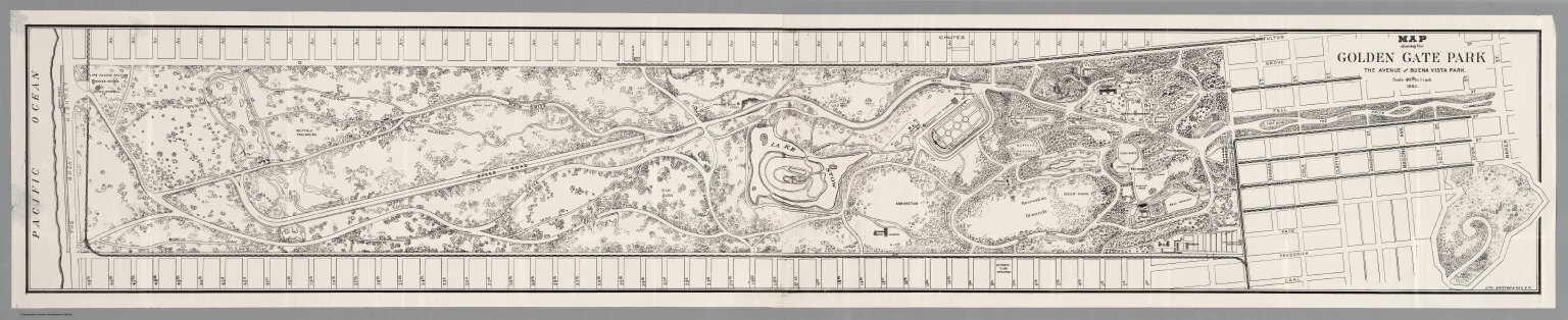
Britton & Rey
Full Title
Map showing the Golden Gate Park, The Avenue And Buena Vista Park. 1903. Lith. Britton & Rey, S.F.
List No
5361.000
Note
Map is without color. Shows various buildings and bicycle routes.
Author
Lecount, Josiah J.
Full Title
Official Map Of The City Of San Francisco, California. Published by Josiah J. Lecount, Manufacturer & Importer Of Stationery & Miscellaneous Books, Montgomery St., San Francisco. Approved By Geo. R. Turner, City & County Surveyor, 1859. Lithy. Of Britton & Co. S.F.
List No
5873.000
Note
Wall map version of our 2543.000. Early map of the city. Says "Approved by Geo. R. Turner, City & County Surveyor." Shows division of lots, shoreline. Map is without color.
Author
Pacific Gas and Electric Company
Full Title
San Francisco Bay Metropolitan Area (Comprising the Nine Counties Bordering on the Bay). Copyrighted By Pacific Gas And Electric Company December 1932 And Presented To San Francisco Bay Industrial Committee. Compliments of Pacific Gas and Electric Company, San Francisco. (with 2 inset maps of California). (with views of) the Golden Gate Bridge at San Francisco ... (and) San Francisco - Oakland Bay Bridge ...
List No
8131.000
Note
Bird's-eye-view from the Pacific Ocean looking eastward. Relief shown pictorially. Shows the bridges, cities, parks, universities, etc. Includes text, statistical data, 2 location maps of California and 2 uncolored panoramic views of Golden Gate Bridge and Bay Bridge.
1-29 of 29
|