|
REFINE
Browse All : Images of California and Oakland (Calif.)
1-41 of 41
Author
[Arnold, T. J. (Thomas Jefferson), d. 1878, California. Board of State Harbor Commissioners for San Francisco Harbor]
Full Title
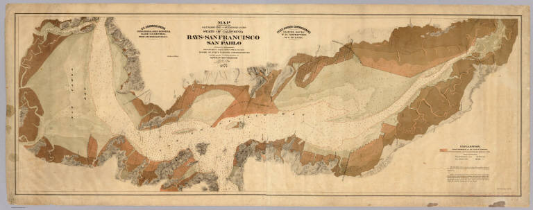
Map exhibiting the salt marsh, tide and submerged lands disposed of by the State of California in and adjacent to the bays of San Francisco and San Pablo and now subject to reclamation. Prepared from maps of the U.S. Coast Survey & official records by order of the Board of State Harbor Commissioners for the United States Commissioners on San Francisco Harbor. By T.J. Arnold, engineer of the sea wall. 1874. U.S. Commissioners Rear Admiral John Rodgers, Major G.H. Mendell, Prof. George Davidson. State Harbor Commissioners Samuel Soule, T.D. Mathewson, D.C. McRuer. Britton Rey & Co. Lith. S.F.
List No
4469.000
Note
This map shows the shoreline property sold by the state to private parties and "now subject to reclamation" (i.e. ready to be filled). The Vogdes map is probably later. An unusual view of the bay, with east at the top; shows water depths. With black top and bottom rollers. With full printed color in subtle tan shades. Printed on 2 sheets. David Rumsey copy mounted as one sheet, backed with cloth.
Author
Thompson & West
Full Title
Mills Seminary, Brooklyn, Alameda Co., Cal. (Published by Thompson & West, Oakland, Cala., 1878)
List No
0999.002
Note
Lithographed view.
Author
Thompson & West
Full Title
Residence of B.W. Reagan, Oakland, Alameda Co., Cal. (Published by Thompson & West, Oakland, Cala., 1878)
List No
0999.005
Note
Lithographed view.
Author
Thompson & West
Full Title
Residence of Col. John C. Hays, Oakland, Alameda County, California. (Published by Thompson & West, Oakland, Cala., 1878)
List No
0999.006
Note
Lithographed view.
Author
Thompson & West
Full Title
Map number two (Alameda County farm map. Published by Thompson & West, Oakland, Cal., 1878)
List No
0999.008
Note
Hand col. lithographed map. Relief shown by hachures. Covers Alameda, Piedmont and parts of Oakland and Emeryville. Shows parcels with owners, tracts, etc. Inset map: Eastern part of the Sobrante Rancho, Eden Tp.
Author
Thompson & West
Full Title
Index map of Oakland. (Published by Thompson & West, Oakland, Cala., 1878)
List No
0999.025
Note
Hand col. lithographed map. Covers also Alameda, Albany, Berkeley, Emeryville and Piedmont.
Author
Thompson & West
Full Title
Res. & ranch of Richard Dowling, Brooklyn Tp. ... Residence of P.F. Marston, Fruit Vale Ave. ... (both) Alameda Co., Cal. (Published by Thompson & West, Oakland, Cala., 1878)
List No
0999.027
Note
Two lithographed views on 1 sheet.
Author
Thompson & West
Full Title
Farm & res. of Michael Curtis ... Poirier Tract of Mrs. DeLima Poirier ... (both) Berkley (sic), Alameda Co., Cal. (Published by Thompson & West, Oakland, Cala., 1878)
List No
0999.030
Note
Two lithographed views on 1 sheet. Poirier Tract is bird's eye view showing street names, lot numbers, etc.
Author
Thompson & West
Full Title
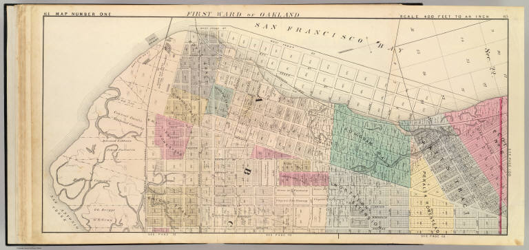
First Ward of Oakland. (Map of Oakland and vicinity) map number one. (Published by Thompson & West, Oakland, Cala., 1878)
List No
0999.032
Note
Hand col. lithographed map. Shows tracts, block and lot numbers, landowners of larger parcels, dimensions of some parcels, etc.
Author
Thompson & West
Full Title
Residence of S.E. Alden, Oakland ... "Harmon Tract," res. & portion of property of E.D. Harmon, North Oakland ... (both) Alameda Co., Cal. (Published by Thompson & West, Oakland, Cala., 1878)
List No
0999.033
Note
Two lithographed views on 1 sheet. Harmon Tract is bird's-eye view showing streets, lots, houses, etc.
Author
Thompson & West
Full Title
Residence & farm of R.S. Farrelly, Brooklyn Tp., Alameda County, Cal. Residence and farm of John Mathews, Brooklyn Tp., Alameda Co., Cal. (Published by Thompson & West, Oakland, Cala., 1878)
List No
0999.034
Note
Two lithographed views on 1 sheet.
Author
Thompson & West
Full Title
Second Ward of Oakland. (Map of Oakland and vicinity) map number two. (Published by Thompson & West, Oakland, Cala., 1878)
List No
0999.035
Note
Hand col. lithographed map. Shows tracts, block and lot numbers, landowners of larger parcels, dimensions of some parcels, etc.
Author
Thompson & West
Full Title
Third Ward of Oakland. (Map of Oakland and vicinity) map number three. (Published by Thompson & West, Oakland, Cala., 1878)
List No
0999.036
Note
Hand col. lithographed map. Shows tracts, block and lot numbers, landowners of larger parcels, dimensions of some parcels, etc.
Author
Thompson & West
Full Title
Fifth Ward of Oakland. (Map of Oakland and vicinity) map number four. (with view) Res. of Conrad Liese, Alameda, Alameda Co., Cal. (Published by Thompson & West, Oakland, Cala., 1878)
List No
0999.037
Note
Hand col. lithographed map with inset view. Shows tracts, block and lot numbers, landowners of larger parcels, dimensions of some parcels, etc.
Author
Thompson & West
Full Title
Fourth & Sixth wards of Oakland. (Map of Oakland and vicinity) map number five. (Published by Thompson & West, Oakland, Cala., 1878)
List No
0999.038
Note
Hand col. lithographed map. Shows tracts, block and lot numbers, landowners of larger parcels, dimensions of some parcels, etc. Covers part of Alameda.
Author
Thompson & West
Full Title
Res. & farm of E. Munyan, Centerville ... Property of W.W. Armstrong, Brooklyn Tp. ... Res. & farm of Jas. F. Kapp, Pleasanton ... (all) Alameda Co., Cal. (Published by Thompson & West, Oakland, Cala., 1878)
List No
0999.040
Note
Three lithographed views on 1 sheet. Armstrong view shows "Halfway House."
Author
Thompson & West
Full Title
South part of Seventh Ward of Oakland. (Map of Oakland and vicinity) map number six. (Published by Thompson & West, Oakland, Cala., 1878)
List No
0999.041
Note
Hand col. lithographed map. Shows tracts, block and lot numbers, landowners of larger parcels, dimensions of some parcels, etc. Covers parts of Alameda, Clinton, San Antonio and vicinity.
Author
Thompson & West
Full Title
North part of Seventh Ward of Oakland. (Map of Oakland and vicinity) map number seven. (Published by Thompson & West, Oakland, Cala., 1878)
List No
0999.044
Note
Hand col. lithographed map. Shows tracts, block and lot numbers, landowners of larger parcels, dimensions of some parcels, etc. Covers parts of Clinton, San Antonio and vicinity.
Author
Thompson & West
Full Title
(Map of Oakland and vicinity) map number eight. (Published by Thompson & West, Oakland, Cala., 1878)
List No
0999.047
Note
Hand col. lithographed map. Shows tracts, block and lot numbers, landowners of larger parcels, dimensions of some parcels, etc.
Author
Thompson & West
Full Title
(Map of Oakland and vicinity) map number nine. (Published by Thompson & West, Oakland, Cala., 1878)
List No
0999.050
Note
Hand col. lithographed map. Shows tracts, block and lot numbers, landowners of larger parcels, dimensions of some parcels, etc.
Author
Thompson & West
Full Title
(Map of Oakland and vicinity) map number ten. (Published by Thompson & West, Oakland, Cala., 1878)
List No
0999.053
Note
Hand col. lithographed map. Shows tracts, block and lot numbers, landowners of larger parcels, dimensions of some parcels, etc.
Author
Thompson & West
Full Title
(Map of Oakland and vicinity) map number eleven ... map number twelve. (Published by Thompson & West, Oakland, Cala., 1878)
List No
0999.056
Note
Two hand col. lithographed maps. Shows tracts, block and lot numbers, landowners of larger parcels, dimensions of some parcels, etc.
Author
Thompson & West
Full Title
(Map of Oakland and vicinity) map number thirteen. (Published by Thompson & West, Oakland, Cala., 1878)
List No
0999.059
Note
Hand col. lithographed map. Shows tracts, block and lot numbers, landowners of larger parcels, dimensions of some parcels, etc.
Author
Thompson & West
Full Title
(Map of Oakland and vicinity) map number fifteen. (Published by Thompson & West, Oakland, Cala., 1878)
List No
0999.065
Note
Hand col. lithographed map. Shows tracts, block and lot numbers, landowners of larger parcels, dimensions of some parcels, etc.
Author
[Boardman, W. F. (William F.), Thompson & West]
Full Title
Boardman map of Haywards, Alameda Co., Cal. (with view) Residence and tannery of G.F. Crist, Brooklyn, Alameda County, California. (Published by Thompson & West, Oakland, Cala., 1878)
List No
0999.074
Note
Hand col. lithographed map, with low oblique view. Shows block and lot numbers, landowners and sizes of larger parcels, etc.
Author
Thompson & West
Full Title
Res. & farm of J.B. Marlin, San Lorenzo ... Res. & farm of P.A. Finigan, Brooklyn Tp. ... (both) Alameda Co., Cal. (Published by Thompson & West, Oakland, Cala., 1878)
List No
0999.109
Note
Two lithographed low oblique bird's-eye views.
Author
[Rand McNalley & Company, Texaco Oil Company]
Full Title
Texaco Road Map California Nevada Spring Edition
List No
10861.002
Note
With Road Map of the United States, maps of San Francisco, Oakland, and Los Angeles., and index.
Author
[Candrian, Herman Anton, Candrian, B.W.]
Full Title
Map of Oakland, Alameda and Berkeley. Copyright, 1906. Unnumbered streets same as nearest number. B.W. Candrian. (on verso) Map of city and county of San Francisco; H.A. Candrian, copyright, 1906. B.W. Candrian.
List No
11071.002
Note
Color map of Oakland, Alameda, Berkeley. Scale ca. 1:35,000, on sheet 39 x 47. shows boundaries, districts, tracts, roads, railways, electric roads, parks, major public buildings, etc. Includes explanations and advertisements.
Author
Schmitt, Paul A.
Full Title
Map of Mills College. Paul A. Schmitt.
List No
11188.000
Note
Bird's-eye-view pictorial map of the Mills College campus in Oakland, California, by Paul A. Schmitt. Date estimated. Shows street, various buildings, wooded areas, etc. There are three vignette illustrations: Lake Aliso, Art Gallery and Gold Hollow; plus an inset map in upper left corner "Our College World" showing the San Francisco Bay Area. In a charming touch. Includes decorative compass at the right and portraits of Cyrus Taggart Mills and Susan Tolman Mills at lower edge. An arrow leading out of the picture at the lower edge is marked "Remember Who You Are." "Enter to search for truth in joyous study - depart to use in life the truth here found"
Author
[Československá akademie věd., Klíma, Jan]
Full Title
Spojené Státy Amerika. Československý vojenský atlas̊.
List No
13684.159
Note
5 maps on 1 sheet. Including: Aleutian Islands (Alaska) , Hawaiian Islands, San Francisco and surroundings, Los Angeles and San Francisco and Oakland. Relief shown by gradient tints, hachures and spot heights. Depth shown by bathymetric tints, isolines and soundings.
Author
U.S. Coast and Geodetic Survey
Full Title
San Francisco entrance, California. Published at Washington, D.C. September, 1903. By the U.S. Coast and Geodetic Survey, O.H. Tittmann, Superintendent. ... Additions to topography from other sources to July, 1905.
List No
3480.000
Note
Adds Richmond and Santa Fe in the East Bay to earlier editions. Relief shown by contours and spot heights; soundings in fathoms and feet. C. & G.S. [Chart] no. 5532. Plate no. 2706. Seal of Dept. of Commerce and Labor, United States of America above title. David Rumsey Collection copy: stamped on is "8 05.19"; affixed to verso is certification indicating its use in a legal matter.
Author
U.S. Coast and Geodetic Survey
Full Title
United States - West Coast. San Francisco entrance, California. United States of America Department of Commerce ... Published at Washington, D.C., Dec. 1926. By the U.S. Coast and Geodetic Survey. E. Lester Jones, Director.
List No
3481.000
Note
Later edition showing urban expansion. Relief shown by contours and spot heights; soundings in feet. U.S.C. & G.S. [Chart] no. 5532. Seal of Dept. of Commerce above title. Plate no. 3772. David Rumsey Collection copy correct to date of issue: Jul. 30, 1927.
Author
Thomas Bros.
Full Title
(Covers to) Thomas Bros. New Map Of City And County Of San Francisco. Published By Thomas Bros. Map Publishers, 461 Market Street, San Francisco ... 361 7th Street, Oakland ... Copyrighted By Thomas Bros. (on verso) New Map Of Oakland, Berkeley, Alameda, San Leandro, Piedmont, Emeryville, Albany ...
List No
3669.001
Note
Map of San Francisco on one side, Oakland-Albany on the other. Date is estimated. Map folds into brown card board covers 22x13 printed with the title "Thomas Bros. Map San Francisco, Oakland, Berkeley, Alameda, San Leandro, Piedmont, Emeryville, Albany. 25c. Compiled And Published By Thomas Bros. Map Publishers ..."
Author
Thomas Bros.
Full Title
Thomas Bros. New Map Of City And County Of San Francisco. Published By Thomas Bros. Map Publishers, 461 Market Street, San Francisco ... 361 7th Street, Oakland ... Copyrighted By Thomas Bros. (on verso) New Map Of Oakland, Berkeley, Alameda, San Leandro, Piedmont, Emeryville, Albany ...
List No
3669.002
Note
Map of San Francisco on one side, Oakland-Albany on the other. Printed with no color. Date is estimated. Map folds into brown card board covers 22x13 printed with the title "Thomas Bros. Map San Francisco, Oakland, Berkeley, Alameda, San Leandro, Piedmont, Emeryville, Albany. 25c. Compiled And Published By Thomas Bros. Map Publishers ..." Includes street index and Index to Principal Office Buildings.
Author
Thomas Bros.
Full Title
New Map Of Oakland, Berkeley, Alameda, San Leandro, Piedmont, Emeryville, Albany ... (on verso) Thomas Bros. New Map Of City And County Of San Francisco. Published By Thomas Bros. Map Publishers, 461 Market Street, San Francisco ... 361 7th Street, Oakland ... Copyrighted By Thomas Bros.
List No
3669.003
Note
Map of San Francisco on one side, Oakland-Albany on the other. Printed with no color. Date is estimated. Map folds into brown card board covers 22x13 printed with the title "Thomas Bros. Map San Francisco, Oakland, Berkeley, Alameda, San Leandro, Piedmont, Emeryville, Albany. 25c. Compiled And Published By Thomas Bros. Map Publishers ..." Includes street index and Index to Principal Office Buildings.
Author
Allardt, G. F.
Full Title
Sale map no. 11. Salt marsh and tide lands situate in the counties of Alameda & Contra Costa, state of California. To be sold at public auction by order of the Board of Tide Land Commissioners ... Greenbaum & Co. Auctioneers. Sale to commence Wednesday July 10th 1872, at 11 A.M. at the sales rooms of Greenbaum & Co. Nos. 115 & 117 Bush Street, San Francisco. R.P. Johnson, Edgar Briggs, C.M. Stratton, Board of Tide Land Commissioners. J.M. Currier, Secretary. G.F. Allardt, Chief Engineer. Lith. Britton & Rey S.F. (inset) Tide lands in Lake Merritt.
List No
3972.000
Note
This map is double the size of the usual tide land maps and shows the shore of the east bay from Oakland north to Point San Pablo. Cadastral map showing drainage, township and section lines, land ownership, ranchos, lot numbers, railroads, etc. Map is without color (for hand colored copy see our 4470). Printed on 2 sheets, mounted together.
Author
Allardt, G. F.
Full Title
Sale map no. 11. Salt marsh and tide lands situate in the counties of Alameda & Contra Costa, state of California. To be sold at public auction by order of the Board of Tide Land Commissioners ... Greenbaum & Co. Auctioneers. Sale to commence Wednesday July 10th 1872, at 11 A.M. at the sales rooms of Greenbaum & Co. Nos. 115 & 117 Bush Street, San Francisco. R.P. Johnson, Edgar Briggs, C.M. Stratton, Board of Tide Land Commissioners. J.M. Currier, Secretary. G.F. Allardt, Chief Engineer. Lith. Britton & Rey S.F. (inset) Tide lands in Lake Merritt.
List No
4470.000
Note
This map is double the size of the usual tide land maps and shows the shore of the east bay from Oakland north to Point San Pablo. Cadastral map showing drainage, township and section lines, land ownership, ranchos, lot numbers, railroads, etc. Hand colored (for uncolored copy see our 3972). Printed on 2 sheets, mounted together.
Author
[McClure, W. F. (Wilbur F.), Patterson, Smith & Co.]
Full Title
Claremont Heights Subdivision No. 1. Choice Berkeley villa sites. W.F. McClure, City Engineer of Berkeley. Patterson, Smith & Co., Inc., 2107 University Avenue, Berkeley, Cal. (1910?)
List No
5317.002
Note
Cadastral map showing lot numbers and dimenstions, streets, sewer lines, etc. On verso of: Map of Berkeley.
Author
[King, M. G. (Malcolm G.), William J. Dingee]
Full Title
Map of Oakland, Berkeley and Alameda. William J. Dingee, agent. For the purchase, sale, appraisal and care of real estate. 460 & 462 Eighth Street near Broadway, Oakland. M.G. King, C.E., surveyor. Entered ... in the year 1878, by Woodward & Taggart in the office of the Librarian of Congress at Washington, D.C. Galloway Litho Co., 418-422 Commercial St., S.F. (1884?)
List No
5725.001
Note
Uncolored lithographic map. Shows drainage, block numbers, ownership of large parcels, railroads, charter line, Oakland Harbor improvements, etc. Includes location map. Covers also Emeryville, Piedmont and Albany. Oriented with north toward left. Jackson, Vandercook & Melvin advertisement on verso. David Rumsey Collection copy: has annotations in black and col. pencil.
Author
[King, M. G. (Malcolm G.), William J. Dingee]
Full Title
W.F. Melvin, E.F. Vandercook, R.D. Jackson. Jackson, Vandercook & Melvin, successors to C.W. McLaughlin & Co. Real estate and insurance agents, 458 Ninth Street. Telephone No. 285. Oakland, Cal. (1884?)
List No
5725A
Note
Lithographed advertisement. On verso of: Map of Oakland, Berkeley and Alameda.
Author
[E.P. Vandercook & Co., H.S. Crocker & Co.]
Full Title
Map of the City of Oakland, Berkeley, Oakland & Brooklyn Townships and Alameda. Published by E.P. Vandercook & Co. Real estate agents. 458 Ninth St. Oakland, Cal. Lith. H.S. Crocker & Co. S.F. (inset: Map of San Francisco Bay Area showing relative location of Oakland).
List No
9975.000
Note
Outline color map, 67x94, mounted on linen, folded into dark brown cloth covers, with blind stamped on the front cover. Covers also Emeryville and Piedmont. Shows streets, townships, block numbers, tracts, partial land ownership, railroads, proposed electric, drainage, radial distances from downtown Oakland, etc. Includes compass rose oriented with north toward upper left. Date estimated.
1-41 of 41
|