|
REFINE
Browse All : Images of California and Colorado
1-22 of 22
Author
[Berghaus, Heinrich, Berghaus, Hermann, Schmidt, C., Risch, M.]
Full Title
Tieflander. Entw. v. Herm. Berghaus 1883, Ausg. 1887. Gez. v. C. Schmidt u. M. Risch. Gotha: Justus Perthes. (On upper margin) I. Abt. Geologie No. II. Berghaus' physikal atlas No. 2. (to Accompany) Berghaus' Physikalischer Atlas. (Begrundet 1836 durch Heinrich Berghaus) ... Gotha: Justus Perthes. 1892.
List No
4391.013
Note
14 color lithograph maps with insets on 1 sheet. Includes: Die Heutigen Niederlande, with insets: Niederlande in 1. Jahrhundert -- Niederlande in X. Jahrhundert, at scale of 1: 6,000,000. Fen District -- El-Ghor oder das Jordan Thal -- Kaspisches Tiefland und Manytsch Niederrung -- Natron-Seen -- El Fajum -- Nordrand der Libyschen Wuste -- Das Todte Thal -- Colorado-Wuste -- Nordrand der Algerischen Sahara -- Goban n. Paulistischke -- Sud-Australische Seen -- Tiefland Asale -- Assal-See. Relief shown by contours and spot heights. Depth shown by gradient tints and soundings. Prime meridian is Greenwich.
Author
Colton, G.W.
Full Title
Colton's Map of California, Nevada, Utah, Colorado, Arizona & New Mexico. Published By J. H. Colton. No. 172 William St. New York.
List No
0151.062
Note
Shows routes, dates of exploration and the explorers. Prime meridians are Greenwich and Washington D.C. Relief shown by hachures
Author
Colton, G.W.
Full Title
Colton's Map of California, Nevada, Utah, Colorado, Arizona and New Mexico. Published By G. W & C. B. Colton & Co. No. 172 William St. New York.
List No
0152.064
Note
Prime meridians are Washington D.C. and Greenwich.
Author
Johnson, A.J.
Full Title
Johnson's California, With Territories of Utah, Nevada, Colorado, New Mexico And Arizona,Published By Johnson and Ward. Entered ... 1864, by A.J. Johnson ... New York.
List No
0352.044
Note
Full color by counties, with heavy outlines around the states. detail mining districts, political divisions, emigrant trails, the Santa Fe Trail, the Pony Express Route, several proposed Union Pacific railroads, and Indian tribes and territories. This important map went through several different states during its publication period from 1860 to 1870. This critical period in westward expansion saw incredible development and change throughout the region. This, the 1864 Johnson and Ward version represents a complete re-engraving of the 1862-1863 map. Johnson added considerable detail in the mountainous regions of California, Nevada and Colorado. Arizona and New Mexico appear as independent territories but shows the old "New Mexico" county structure. The southern boundary of Nevada with Arizona is set at 37 degrees of Latitude such that Las Vegas, shown within Arizona. Relief shown by hachures. Prime meridians are Greenwich and Washington D.C.
Author
Johnson, A.J.
Full Title
Johnson's California also Utah, Nevada, Colorado, New Mexico, and Arizona. Entered ... 1864.
List No
0358.049
Author
[Morse, Charles W., Colby, Charles A.]
Full Title
California. (inset) Utah and Part of New Mexico.
List No
0623.041
Author
[Scovel, James L., O'Brien, Emmett J]
Full Title
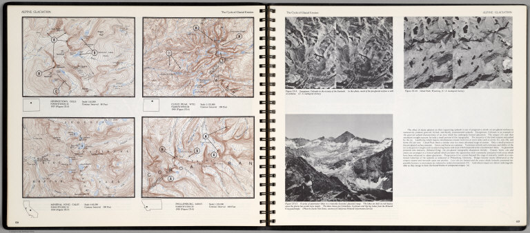
Alpine Glaciation. The Cycle of Glacial Erosion. Georgetown, Colo. Scale 1:62,500. Cloud Peak, Wyo. Scale 1:125,000. Mineral King, Calif. Scale 1:62,500. Phillipsburg, Mont. Scale 1:125,000.(on opposite page three views of )The Cycle of Glacial Erosion.
List No
0889.057
Note
Four on one page, with text, and location map. Includes three views of Georgetown, Colorado; Cloud Peak, Wyoming; and A series of paternoster lakes in a maturely dissected glacial range. Relief shown by contours and spot heights.
Full Title
Diurnal barometric curves. Horary curves Georgetown, Col. ... Colorado Springs, Col. ... Green River, Wyo. Terr. ... Los Angeles, Cal. ... Salt Lake City, Utah ... Santa Fe, New Mexico ... U.S. Geographical Surveys West of the 100th Meridian. (1877)
List No
2220.048
Note
Lithographed chart, b&w. Hourly observations taken 1872-1875.
Full Title
Diurnal barometric curves. Horary curves Hughes, Col. ... Labran, Col. ... Camp Independence, Cal. ... Cottonwood Springs, Nev. ... Beaver, Utah ... U.S. Geographical Surveys West of the 100th Meridian. (1877)
List No
2220.049
Note
Lithographed chart, b&w. Hourly observations taken 1871-1873.
Full Title
Diurnal temperature. Beaver, Utah. Camp Independence, Cal. Labran, Col. Hughes, Col. Cottonwood Springs, Nev. U.S. Geographical Surveys West of the 100th Meridian. (1877)
List No
2220.053
Note
Lithographed chart, b&w. Hourly observations taken 1871-1873.
Full Title
Mean differences, wet and dry bulb thermometers. Beaver, Utah. Camp Independence, Cal. Labran, Col. Hughes, Col. Cottonwood Springs, Nev. U.S. Geographical Surveys West of the 100th Meridian. (1877)
List No
2220.056
Note
Lithographed chart, b&w. Hourly observations taken 1871-1873.
Full Title
Diurnal force of vapor. Colorado Springs, Col. Salt Lake City, Utah. Los Angeles, Cal. Santa Fe, New Mex. Georgetown, Col. Green River, Wyo. Terr. U.S. Geographical Surveys West of the 100th Meridian. (1877)
List No
2220.058
Note
Lithographed chart, b&w. Hourly observations taken 1873-1875.
Full Title
Diurnal force of vapor. Beaver, Utah. Cottonwood Springs, Nev. Hughes, Col. Labran, Col. Camp Independence, Cal. U.S. Geographical Surveys West of the 100th Meridian. (1877)
List No
2220.059
Note
Lithographed chart, b&w. Hourly observations taken 1871-1873.
Full Title
(Diurnal) relative humidity. Georgetown, Col. Los Angeles, Cal. Colorado Springs, Col. Salt Lake City, Utah. Santa Fe, New Mex. Green River, Wyo. Terr. U.S. Geographical Surveys West of the 100th Meridian. (1877)
List No
2220.061
Note
Lithographed chart, b&w. Hourly observations taken 1872-1875.
Full Title
Diurnal relative humidity. Camp Independence, Cal. Cottonwood Springs, Nev. Beaver, Utah. Hughes, Col. Labran, Col. U.S. Geographical Surveys West of the 100th Meridian. (1877)
List No
2220.062
Note
Lithographed chart, b&w. Hourly observations taken 1871-1873.
Author
Schonberg & Co.
Full Title
California and the Western Territories.
List No
4324.024
Note
Relief shown in hachures. Prime meridians are Greenwich and Washington D.C. Counties differentiated by full color. A generalized map seriously lacking in detail.
Author
Johnson, A.J.
Full Title
Johnson's California, Utah, Nevada, Colorado, New Mexico, and Arizona. Published by A. J. Johnson, New York. 79. 80. Entered according to the Act of Congress, in the year 1864, by A.J. Johnson in the Clerk's Office of the District Court of the United States for the Southern District of New York.
List No
4574.040
Note
Engraved color map with counties and districts differentiated by color. Shows roads and railroads. Major relief shown by hachures.
Author
Colton, G.W.
Full Title
Colton's Map of California, Nevada, Utah, Colorado, Arizona & New Mexico. Published by G.W. & C.B. Colton & Co., No. 172 William St. New York.
List No
4825.060
Note
Shows routes, dates of exploration and the explorers. Prime meridians are Washington D.C. and Greenwich. Relief shown by hachures
Author
Johnson, A.J.
Full Title
Johnson's California, Utah, Nevada, Colorado, New Mexico, and Arizona. Published by Alvin J. Johnson & Co., New York. 79. 80. Entered according to the Act of Congress, in the year 1864, by A.J. Johnson in the Clerk's Office of the District Court of the United States for the Southern District of New York.
List No
4828.055
Note
Engraved color map with counties and districts differentiated by color. Shows roads and railroads. Major relief shown by hachures.
Author
Johnson, Alvin Jewett, 1827-1884.
Full Title
Johnson's California, also Utah, Nevada, Colorado, New Mexico and Arizona. Published by Alvin J. Johnson & Son, New York. Entered ... 1864, by A.J. Johnson ... New York. (to accompany) Johnson's New Illustrated Family Atlas Of The World ... MDCCCLXXX (1880).
List No
4830.097
Note
Engraved hand colored in outline map. Shows state and county boundaries, towns, villages, forts, Indian habitation, explorers routes, mining districts, roads, railroads, canals, lakes, mountains and rivers. Relief shown by hachures. Prime meridians are Greenwich and Washington.
Author
Rand McNally and Company
Full Title
Denver and vicinity. San Francisco and vicinity. Los Angeles and vicinity. Copyright by Rand McNally & Co., Chicago, Ill. (1927)
List No
5755.050
Note
Three maps on facing pages. In blue ink. Relief shown by hachures and spot heights. Show settlements, classified roads with distances, etc.
Author
[Fred Harvey, F.G.]
Full Title
(Southwest). (inset) Grand Canyon Natonal Park and Vicinity.
List No
9062.003
1-22 of 22
|