|
REFINE
Browse All : Images of California and California, Northern
1-13 of 13
Author
Anonymous
Full Title
Kaliforniya. (Kalifornia) Verkhnyaya Kaliforniya.
List No
11957.000
Note
Engraved map in Russian of Northern California and Mexico, Baja California. Shows international and administrative boundaries, cities, towns, rivers and mountains. Relief shown by hachures. Date is estimated based on showing of Pyramid Lake from the Fremont 1845 map. The map appears to have been published in Russia as a separate map, not in any reports we can locate. It shows the Russian settlement at Fort Ross on the California coast. It might have been a map advocating for increased Russian exploration and settlement in California. There is no mention of the gold rush on the map, thus it is likely to have been published before 1849. We have not been able to located any other copies at libraries.
Author
[Hesemeyer, Otto, Pacific Gas and Electric Co.]
Full Title
Northern and Central California, the Land of Golden Horizons served by Pacific Gas and Electric Co. Otto Hesemeyer. Copyright 1957 by Pacific Gas and Electric Co.
List No
11324.000
Note
Color map. Shows roads, railroads, major cities, major airports, agricultural areas and wooded areas. Relief shown pictorially and by shadings.
Author
Pacific Gas and Electric Company
Full Title
Gas and electric transmission system and territory served by Pacific Gas and Electric Co. 1939. 52528. supersedes 50835.
List No
11052.000
Note
Uncolored map. Covers northern California, from the Oregon border to Monterey and Fresno. Shows transmission system of Pacific Gas and Electric Company, generating stations, high voltage power lines provided to cities and towns in northern and central California. Includes legend and table: Record of nine year's growth.
Author
Blum, George W.
Full Title
Untitled map of Sonoma, Marin, Lake, and Napa Counties.
List No
1592.002
Note
Bike paths shown in red and labeled with abbreviations. The first abbreviation of the two tells the road condition. Conditions are: G (good), F (fair), P (poor), and V.P. (very poor). The second abbreviation is for the grade of the road. Grades include: L (level), R (rolling), H (hilly), and M (mountainous).
Author
[Cram, George Franklin, Murray-Aaron, Eugene, 1852-1941.]
Full Title
Northern half California. (to accompany) Cram's atlas of the world, ancient and modern : new census edition -- indexed.
List No
1910.058
Note
In full color on 2 pages. Relief shown by hachures. Shows administrative divisions, cities and towns, railroads, roads, rivers, etc. Prime meridian is Greenwich.
Author
California. State Earthquake Investigation Commission
Full Title
Map of the Coast Range Region of Middle California showing the distribution of earth movement on April 18, 1906 as revealed by the displacement of the triangulation stations of the Coast and Geodetic Surveyed, determined by resurvey, 1906-07. Drawn by M. Solem. Earthquake Investigation Commission. A. Hoen & Co., Baltimore. (Carnegie Institution of Washington. 1908)
List No
2130.024
Note
Color. Shows fault of 1906, movement of 1906, successive movements of 1868 and 1906, combined movements of 1868 and 1906, railroads, settlements, etc.
Full Title
Views along the line of the San Francisco and North Pacific Railway. The picturesque route of California. (Published by Reynolds & Proctor, Santa Rosa, Cal., 1898)
List No
3341.093
Note
Nine photographic illustrations on 1 sheet: Hop yard -- Vineyard -- The Devil's Canyon at the Geysers -- Fish Hatchery of S.F. & N.P. Ry. in Gibson Canyon near Ukiah -- Pendulous Oak -- Gateway to Bohemia--Redwood Forest near Guerneville -- Interior view of San Francisco and North Pacific Railway hatchery -- Where the trout hide -- Stock farm.
Author
La Perouse, Jean-Francois de Galaup, comte de, 1741-1788
Full Title
Carte particuliere de la cote du nord-ouest de l'Amerique reconnue par les Fregates Francaises la Boussole et l'Astrolabe en 1786. 3e. feuille. Bouclet sculp. Herault scrip. Atlas du Voyage de la Perouse no. 31. (Paris: L'Imprimerie de la Republique, An V, 1797)
List No
3355.031
Note
Engraved map. Relief shown by hachures. Covers coast from Tillamook Head to Monterey Bay area. Shows route of La Perouse. Prime meridian: Paris.
Author
Rand McNally and Company
Full Title
Rand, McNally & Co.'s new business atlas map of California. Copyright, 1892, by Rand, McNally & Co. (Chicago, 1897)
List No
3565.146
Note
Col. map. Relief shown by hachures and spot heights. Shows railroads, townships, reservations, etc. Insets: (Central California from Sacramento to Fresno). Scale (ca. 1:875,000) -- (Portion of Southern California from Los Angeles to San Diego). Scale (ca. 1:1,000,000). Title in margin: Rand, McNally & Company's Indexed atlas of the world. California.
Author
[Central Pacific Railroad Company, Union Pacific Railroad Company]
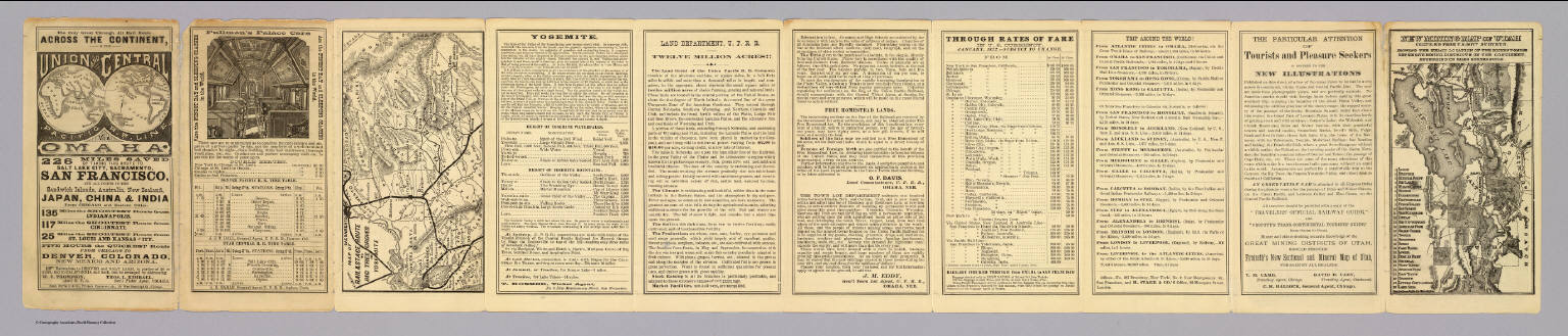
Full Title
(Text Page to) The only great through all rail route is the Union and Central Pacific R.R. line via Omaha ... Rand, McNally & Co., Printers Engravers, etc., 108 West Randolph St., Chicago ... Through time table, in effect January 1, 1872. (with) Map of rail & stage route to Big Tree Groves and Yosemite. (with) New mining map of Utah compiled from U.S. Govt. Surveys ... Nat. Railway Public Co., Philadelphia.
List No
4107.001
Note
10 p. on 1 sheet. Includes tables and text, an ad for Froiseth's new sectional and mineral map of Utah, and 2 maps. Big Tree Groves and Yosemite map at (ca. 1:1,900,000) scale. Utah map at (ca. 1:1,800,000). Relief shown by hachures. Utah map shows mining districts, etc.
Author
[Ferry, Hypolite, Marzolla, Benedetto]
Full Title
Nuova California, Stati Uniti dell'America Settentrionale. (with) Carta particolare delle Baie di Monterey e di Francisco disegnata secondo i lavori idrografici piu recenti. La presente Carta e stata eseguita su quella, pubblicata nel 1850 dal Signr. Ipolito Ferry ... Atlante Geografico di B. Marzolla. Napoli, 1851.
List No
4714.040
Note
Lithographed map with inset. Hand col. Relief shown by hachures and spot heights. Includes notes. Prime meridian: Paris.
Author
[Bancroft, A.L., Knight, W.H.]
Full Title
(Covers to) Bancroft's New Map Of Central California Compiled by Wm. Henry Knight. San Francisco, A.L. Bancroft & Company. 1871.
List No
5184A
Author
[Bancroft, A.L., Knight, W.H.]
Full Title
Bancroft's New Map Of Central California Compiled by Wm. Henry Knight. San Francisco, A.L. Bancroft & Company. 1871.
List No
5184.001
Note
The title of the map on the cover calls it "revised and enlarged" which means larger than the 1869 issue of the map (see our #4106) that showed the San Francisco Bay area and the country west to Sacramento, north to southern Lake County and south to Santa Cruz. This 1871 map extends west to Virginia City in Nevada, north to Fort Bragg and south to Santa Cruz, adding Yosemite Valley and the Sierra Nevada gold country, Lake Tahoe, the Central Pacific Railroad completed over Donner Pass, and a large part of the Central Valley. At a scale of 12 miles to one inch, this map is twice the scale of the Bancroft/Knight Map of the Pacific States and the various spin off maps from it, thus showing more detail. Not listed by Vogdes or Wheat or in any references. Full color by county, map is folded into tan and red card board covers 16.5x11 printed with title "Bancroft's New Map Of Central California Revised And Enlarged. San Francisco: A.L. Bancroft & Company, 1871."
1-13 of 13
|