|
REFINE
Browse All : Images of Buffalo (N.Y.)
1-29 of 29
Author
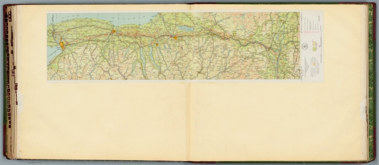
[Ford Motor Company, U.S. Coast and Geodetic Survey]
Full Title
Airway map no. 119 : Buffalo N.Y. to Albany N.Y. Compiled and printed for the Aeronautics Branch of the Department of Commerce by the Coast and Geodetic Survey, Washington, D.C. 1929.
List No
14501.037
Note
Aeronautical chart representing the areas from Buffalo to Albany, New York. Features military, municipal, and commercial landing fields, as well as beacons. Also shows political boundaries, roads, railways, cities, towns, topography, bodies of water, drainage, and shorelines. Relief shown with contour lines and color coding. Map includes a legend, scale statement, and bar scale given in miles, as well as a compass rose oriented toward top of sheet. With the seal of the Department of Commerce, United States of America. Color lithograph. Map is 26 x 106 cm, on double sheet, 60 x 135 cm.
Author
Appleton, D. & Co.
Full Title
Map of Buffalo, New York. Copyright 1891 by Matthews-Northrup Co. ... Buffalo, New York. (to accompany) The Library Atlas Of Modern Geography ... New York, D. Appleton And Company 1892. (on upper margin) Buffalo. 88.
List No
0026.228
Note
Color plan. Shows railways, street car lines, city blocks, parks, etc. Includes numerical references to hotels, churches, major buildings, and points of interest.
Full Title
City of Buffalo. Copyright 1895, Julius Bien & Company, N.Y.
List No
0071.033
Note
Col. lithographed map. Shows streets, railroads, wards, parks, major buildings, lighthouses, etc.
Author
Colton, G.W.
Full Title
Colton's New York. (insets) Oswego, Buffalo, Rochester, Syracuse, Albany, Troy, Vicinity of New York City. Published By J. H. Colton. No. 172 William St. New York.
List No
0151.030
Note
Map showing the county boundaries in color and Niagara Falls. Prime meridians are Greenwich and Washington D. C.
Author
Colton, G.W.
Full Title
Colton's New York. (inset) Oswego, Buffalo, Rochester, Syracuse, Albany, Troy, Vicinity of New York City. Published by G. W & C. B. Colton & Co., No. 172 William St. New York.
List No
0152.029
Note
Prime meridians are Washington D.C. and Greenwich.
Author
Johnson, A.J.
Full Title
Johnson's New York By Johnson and Ward. (inset) Albany. (inset) Troy. (inset) Vicinity of New York (City). (inset) Buffalo. (inset) Rochester. (inset) Syracuse. (inset) Oswego.
List No
0352.021
Note
Full color by county, with heavy outlines around the state. Prime meridians are Greenwich and Washington D.C. Relief shown by hachures.
Author
Mitchell, Samuel Augustus
Full Title
County map of the state of New York. (with) Buffalo. (with) Rochester. (with) West Troy, Troy. (with) Albany. (with) Harbor and vicinity of New York. Drawn and engraved by W.H. Gamble, Philadelphia. Entered ... 1879 by S. Augustus Mitchell ... Washington. (1880)
List No
0586.015
Note
Hand colored map with 5 insets. Relief shown by hachures. Shows settlements, rivers, canals, railroads, etc. Prime meridians: Greenwich and Washington.
Author
Mitchell, Samuel Augustus Jr.
Full Title
County map of the state of New York. (with) Map of New York City and vicinity. (with) Albany. (with) Rochester. (with) Buffalo. (with) Troy, West Troy. Drawn and engraved by W.H. Gamble, Philadelphia. Copyright by S. Augustus Mitchell 1884.
List No
0592.016
Note
Hand colored. Relief shown by hachures. Shows settlements, railroads, rivers, canals, etc. Prime meridians: Greenwich and Washington.
Full Title
County map of the state of New York. (with) Map of New York City and vicinity. (with) Albany. (with) Rochester. (with) Buffalo. (with) Troy, West Troy. Drawn and engraved by W.H. Gamble, Philadelphia. Copyright 1887 by Wm. M. Bradley & Bro. (1890)
List No
0594.015
Note
Hand colored. Relief shown by hachures. Shows settlements, railroads, rivers, canals, etc. Prime meridians: Greenwich and Washington.
Author
Nirenstein, Nathan
Full Title
Business Section, City of Buffalo (New York).
List No
12507.035
Author
Geological Survey (U.S.)
Full Title
Urban areas : Milwaukee, Wis. -- Cleveland, Ohio -- Chicago, Ill. -- Detroit, Mich. -- Pittsburgh, Pa. -- Buffalo, N.Y. -- Cincinnati, Ohio -- Boston, Mass. -- Philadelphia, Pa. -- Atlanta, Ga. -- New Orleans, La. -- Miami, Fla.
List No
14359.035
Note
Twelve maps representing urban areas in the United States, as of 1970. Maps show political boundaries, cities, railways, roads, ferry lines, national forests, mountains, bodies of water, swamps, drainage, coastlines and islands. Relief shown with labeling of mountain names and peak heights. Features population density for each city. Maps include latitudinal and longitudinal lines and scale statements. Colored lithograph. Together, maps are 42 x 65 cm, on double sheet 49 x 71 cm. Index map and legend appear on page 5. Maps appear in General reference maps section.
Author
Cram, George Franklin, 1841-1928
Full Title
City of Buffalo.
List No
14372.236
Note
Map of Buffalo, New York. Shows political boundaries, railroads, streets, ferry lines, parks, bodies of water, drainage, shoreline and islands. Colored lithograph. Map is 41 x 29 cm, on sheet 45 x 33 cm.
Author
Colton, G.W.
Full Title
Colton's New York. (insets) Oswego, Buffalo, Rochester, Syracuse, Albany, Troy, Vicinity of New York City. Published by G. W & C. B. Colton & Co., No. 182 William St. New York.
List No
1550.027
Note
Prime meridians are Washington D.C. and Greenwich.
Author
[Cram, George Franklin, Murray-Aaron, Eugene, 1852-1941.]
Full Title
Map of Buffalo. Published by George F. Cram, Chicago, Ill. (to accompany) Cram's atlas of the world, ancient and modern : new census edition -- indexed.
List No
1910.081
Note
In full color on 2 pages. Shows city blocks, roads, railroads,public buildings, river, park, etc.
Author
Rand McNally and Company
Full Title
Rand, McNally & Co.'s Buffalo and Baltimore.
List No
2094.064
Note
Baltimore map at 1:45,000. Counties outlined in color. Railroads highlighted. Relief shown by hachures.
Author
Mitchell, Samuel Augustus
Full Title
County map of the state of New York. (with) Troy, West Troy. (with) Albany. (with) Harbor and vicinity of New York. (with) Rochester. (with) Buffalo. Drawn and engraved by W.H. Gamble, Philadelphia. Entered ... 1870 by S. Augustus Mitchell, Jr. ... Pennsylvania.
List No
2483.013
Note
Hand colored map with 5 insets. Relief shown by hachures. Shows settlements, railroads, canals, rivers, etc. Prime meridians: Greenwich and Washington.
Author
Rand McNally and Company
Full Title
Buffalo.
List No
2790.052
Author
Cram, George Franklin
Full Title
Map of Buffalo and Vicinity.
List No
2809.091
Note
Railroads are indicated by numbers and colors and patterns, and each railroad has the same number and color and pattern . All railroads on each map are in a list keyed to the map.
Author
Rand McNally and Company
Full Title
Rand, McNally & Co.'s Buffalo.
List No
2844.020
Author
Rand McNally and Company
Full Title
Rand, McNally & Co.'s indexed atlas of the world map of Buffalo. Rand, McNally & Co's New business atlas map of Buffalo. Copyright, 1892, by Rand, McNally & Co. ... Engavers, Chicago. (1897)
List No
3565.075
Note
Col. map. Shows major buildings, parks, cemeteries, ferries, etc. In margin: Rand, McNally & Company's.
Author
Magnus, Charles
Full Title
Map of The City of Buffalo. Chs. Magnus lith. New York. (Hand colored map on a letter sheet).
List No
4247.000
Note
A typical Magnus letter sheet with a map of Buffalo. In full color. Date is estimated.
Author
Colton, G.W.
Full Title
Colton's New York. (insets) Oswego; Buffalo; Rochester; Syracuse; Albany;, Troy; Vicinity of New York City. Published by G. W & C. B. Colton & Co., No. 172 William St. New York.
List No
4587.029
Note
Prime meridians are Washington D.C. and Greenwich.
Author
Colton, G.W.
Full Title
Colton's New York. (insets) Oswego, Buffalo, Rochester, Syracuse, Albany, Troy, Vicinity of New York City. Published by G.W. & C.B. Colton & Co., No. 172 William St. New York.
List No
4825.028
Note
Counties shown in color. Prime meridiansare Greenwich and Washington D.C.
Author
Rand McNally and Company
Full Title
Commercial Atlas of America. Rand McNally 14 x 21 Inch Map of Buffalo and Vicinity.
List No
5028.030
Full Title
County map of the state of New York. (with) Map of New York City and vicinity. (with) Albany. (with) Rochester. (with) Buffalo. (with) Troy, West Troy. Drawn and engraved by W.H. Gamble, Philadelphia. Copyright 1886 by Wm. M. Bradley & Bro.
List No
5784.015
Note
Hand colored. Relief shown by hachures. Shows settlements, railroads, rivers, canals, etc. Prime meridians: Greenwich and Washington.
Author
Archar Inc.
Full Title
Buffalo. City Character Print. Produced and Published by Archar Inc. P.O. Box 999 Station U. Toronto, Canada. M8Z 5p9. Copyright 1982. Printed in the U.S.A.
List No
8417.000
Note
Pictorial map with birds-eye view. City Character Print series. Depicting businesses, landmarks, parks, points of interest around Buffalo in that time. Map filled with descriptive notes, figures, and recreational activities. At bottom corner : KS. and GP.
Author
Unique Media Inc.
Full Title
Niagara Falls. Hamilton. Buffalo.
List No
9108.001
Author
Curtis Publishing Company
Full Title
Buffalo.
List No
9687.024
Author
Rand, McNally & Co.
Full Title
Map of Buffalo.
List No
9733.035
1-29 of 29
|