|
REFINE
Browse All : Images of Bangladesh and South Asia
1-21 of 21
Author
Rand McNally and Company
Full Title
Rand, McNally & Company's indexed atlas of the world map of India. (with) Southeastern provinces of India, Further India. (with) Nicobar Islands. Copyright 1892, by Rand, McNally & Co. ... Engravers, Chicago, (1897)
List No
3565.032
Note
Col. map with 2 insets Relief shown by hachures and spot heights. Scale of insets (ca. 1:8,500,000). Shows British provinces, feudatory states, independent states and colonies.Title in margin: Rand, McNally & Company's indexed atlas of the world.
Author
Arrowsmith, John
Full Title
India, by J. Arrowsmith. London, pubd. 15 Feby. 1832 by J. Arrowsmith, 35 Essex Street, Strand.
List No
0036.030
Note
Engraved map. Hand colored boundaries. Relief shown by hachures.
Author
Colton, G.W.
Full Title
Colton's Hindoostan or British India. Published By G. W & C. B. Colton & Co. No. 172 William St. New York.
List No
0152.102
Note
Prime meridians are Greenwich and Washington D. C. Relief shown by hachures. (inset) Continuation of British India.
Author
Johnson, A.J.
Full Title
Johnson's Hindoostan and Farther India. Entered .... 1867.
List No
0358.067
Author
Pinkerton, John, 1758-1826
Full Title
Hindostan. Drawn under the direction of Mr. Pinkerton by L. Hebert. Neele sculpt. 352 Strand. London: published 2d. March 1811 by Cadell & Davies, Strand & Longman, Hurst, Rees, Orme, & Brown, Pater Noster Row.
List No
0732.036
Note
Engraved map. Full hand col. Relief shown by hachures. "Pinkerton's modern atlas."
Author
Heck, Johann Georg, 1795 -1857
Full Title
51. Carte Generale des Indes Orientales ... avec une parte de la Chine.
List No
12128.053
Author
[Československá akademie věd., Klíma, Jan]
Full Title
Přední Indie a Vysoká Asie. Československý vojenský atlas̊.
List No
13684.125
Note
Political and physical Map of India and South Asia. Equidistant Kuzelov projection. Shows boundaries, regions, capitals and major cities. Relief shown by gradient tints, hachures and spot heights. Depth shown by bathymetric tints, isolines and soundings.
Author
Colton, G.W.
Full Title
Colton's Hindostan or British India. Published By G. W & C. B. Colton & Co., No. 182 William St. New York.
List No
1550.100
Note
Prime meridians are Greenwich and Washington D. C. Relief shown by hachures. (inset) Continuation of British India.
Author
[Bartholomew, J. G. (John George), 1860-1920, John Bartholomew & Co.]
Full Title
India - north-eastern section. (with Calcutta Region). The Edinburgh Geographical Institute, John Bartholomew & Co. "The Times" atlas. (London: The Times, 1922)
List No
2113.065
Note
Col. map. Relief shown by hypsometric tints and spot heights; depths by bathymetric tints. Shows shipping routes with distances, etc. Inset at 1:450,000 scale.
Author
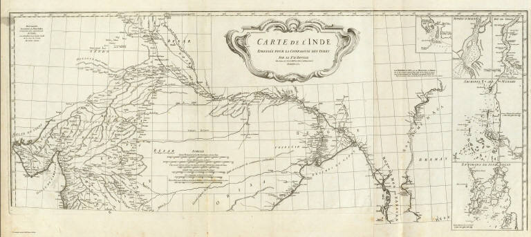
Anville, Jean Baptiste Bourguignon d, 1697-1782
Full Title
Carte de l'Inde. (Northern section). Dressee pour la Compagnie des Indies par le Sr. d'Anville, Secretaire de S.A.S.Mgr. le Duc d'Orleans. (Paris), Novembre 1752. (Grave par Guill? De-la-Haye).
List No
2603.020
Note
Engraved map on 2 sheets. Relief shown pictorially. Inset maps: Negrais -- Riviere d'Aracan -- Riv. de Sirian -- Archipel de Merghi -- Environs de Junk Selon. Includes ornamental cartouche by "H. Gravelot invenit, De Lafosse sculpsit," and geographical notes. David Rumsey Collection copy mounted as 1 sheet. Hand numbered "16" on verso.
Author
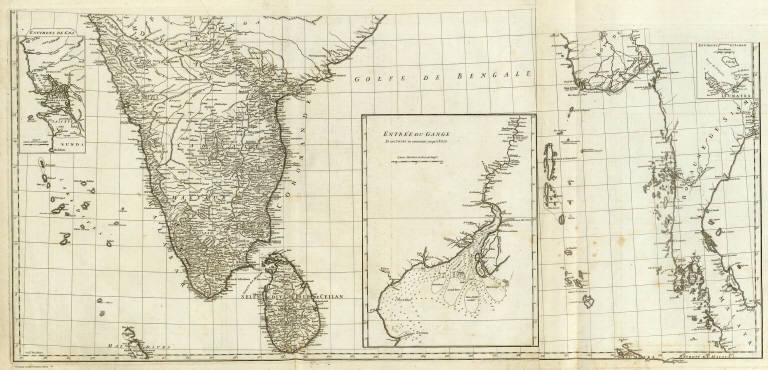
Anville, Jean Baptiste Bourguignon d, 1697-1782
Full Title
(Carte de l'Inde. Southern section. Dressee pour la Compagnie des Indies par le Sr. d'Anville, Secretaire de S.A.S.Mgr. le Duc d'Orleans. Paris, Novembre 1752. Grave par) Guill? De-la-Haye.
List No
2603.021
Note
Engraved map on 2 sheets. Relief shown pictorially. Inset maps: Environs de Goa -- Entree du Gange -- Environs d'Ashem. Ganges delta map has soundings. David Rumsey Collection copy mounted as 1 sheet. Hand numbered "17" on verso.
Author
Anville, Jean Baptiste Bourguignon d, 1697-1782
Full Title
(Composite of) Carte de l'Inde. Dressee pour la Compagnie des Indies par le Sr. d'Anville, Secretaire de S.A.S.Mgr. le Duc d'Orleans. (Paris), Novembre 1752. (Grave par) Guill? De-la-Haye.
List No
2603.022
Note
Engraved map on 4 sheets. Relief shown pictorially. Inset maps: Negrais -- Riviere d'Aracan -- Riv. de Sirian -- Archipel de Merghi -- Environs de Junk Selon -- Environs de Goa -- Entree du Gange -- Environs d'Ashem. Ganges delta map has soundings. Includes ornamental cartouche by "H. Gravelot invenit, De Lafosse sculpsit," and geographical notes. David Rumsey Collection copy mounted as 2 sheets. Hand numbered 16-17 on verso.
Author
Bowen, Emanuel
Full Title
A new and accurate map of the Empire of the Great Mogul, together with India on both sides the Ganges, and the adjacent countries. Drawn from the most approved modern maps and charts: the whole being regulated by astronl. observations, by Eman: Bowen. (London: Printed for William Innys, Richard Ware, Aaron Ward, J. and P. Knapton, John Clarke, T. Longman and T. Shewell, Thomas Osborne, Henry Whitridge ... M.DCC.XLVII)
List No
3733.042
Note
Engraved map. Shows forested areas, shoals, etc. Relief shown pictorially. Includes geographical notes and ornamental cartouche.
Author
Hall, S. (Sidney)
Full Title
Hindoostan. By Sidney Hall. London, published by Longman, Rees, Orme, Brown & Green, Paternoster Row, Novr. 1st. 1827.
List No
4224.028
Note
Engraved map. Boundaries hand col. Relief shown by hachures. Also numbered XXVII.
Author
Colton, G.W.
Full Title
Colton's Hindostan or British India. Published By G. W & C. B. Colton & Co., No. 172 William St. New York.
List No
4587.104
Note
Prime meridians are Greenwich and Washington D.C. (inset) Continuation of British India.
Author
Flemming, Carl
Full Title
Vorderindien. Lithographie, Druck u. Verlag von C. Flemming in Glogau. (1855)
List No
4765.074
Note
Hand colored lithographed map. Relief shown by hachures. Includes inset. Prime meridians: Ferro, Greenwich and Paris.
Full Title
Hindostan. (By Frances Bowen. 1810)
List No
4871.033
Note
Manuscript map. Pen-and-ink and watercolor.
Author
[Edward Stanford Ltd., Stanford, Edward]
Full Title
India and the adjacent parts of Beluchistan, Afghanistan, Turkestan, the Chinese Empire, and Siam. India South. London atlas series. Stanford's Geogl. Estabt. London : Edward Stanford, 26 & 27, Cockspur St., Charing Cross, S.W. (1901)
List No
5075.067
Note
Full color. Relief shown by hachures and spot heights. Shows settlements, roads, railroads, etc.
Author
Letts, Son & Co.
Full Title
General map of India. Letts's popular atlas. Letts, Son & Co. Limited, London. (1883)
List No
5371.081
Note
Colored map. Relief shown by hachures and spot heights. Shows political divisions, cities, railroads, rivers, etc. Inset maps: Continuation of the map on east side of Bay of Bengal, the British provinces beyond the Ganges comprising Arracan, Pegu, Tenasserim, Penang, &c. -- England on the same scale as India.
Author
Letts, Son & Co.
Full Title
Statistical & general map of India. No. 8. Letts's popular atlas. Letts, Son & Co. Limited, London. (1883)
List No
5371.089
Note
Colored map. Relief shown by hachures and spot heights. Shows cities, political divisions, European possessions, telegraph lines, roads, railroads, coffee plantations, forests, lights and lighthouses, etc. Covers Bengal, Bhutan, Chittagong Hill Tracts, Lower Assam, Sikkim, eastern Nepal, etc.
Author
Moll, Herman, d. 1732
Full Title
India Proper or the Empire of the Mogul. Agreeable to modern history. By H. Moll Geographer. (Printed and sold by T. Bowles next ye Chapter House in St. Pauls Church yard, & I. Bowles at ye Black Horse in Cornhill, 1736?)
List No
5580.036
Note
Hand col. engraved map. Relief shown pictorially. Includes geographic notes. David Rumsey Collection copy includes marginal note concerning distances in pen-and-ink.
1-21 of 21
|