|
REFINE
Browse All : Images of Austria from 1874
1-12 of 12
Author
[Hölzel, Eduard, 1817-1885, Ed. Hölzel (Firm), Toula, Franz, 1845-1920, Chavanne, Josef, 1846-1902, Ritter, Franz, -1932]
Full Title
Karte des mittleren und höheren Unterrichtswesens sowie der Elementarbildung der Bevölkerung ausgedrückt durch den Percentsatz der schreibkundigen Recruten im Jahre 1874 / von Franz Ritter von Le Monnier. Ed. Hölzel's geogr. Institut in Wien. Verlag von Ed. Hölzel in Wien.
List No
14348.054
Note
Statistical map of Austria-Hungary. Represents the distribution of education levels - elementary, middle and higher - for Austria-Hungary. Shows political boundaries, cities, railways, roads, valleys, lakes, drainage, coastlines and islands. Includes latitudinal and longitudinal lines, as well as a legend. With three inset maps: Das nördliche Böhmen [= Northern Bohemia] -- Prag mit Vororten [= Prague with suburbs] -- Wien mit Vororten [= Vienna with suburbs]. Colored lithograph. Map is 42 x 57 cm, on double sheet 49 x 65 cm. Descriptive text for Nr. 18 follows map.
Author
Mayr, Johann Georg, 1800-1864
Full Title
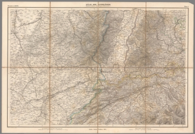
Atlas der Alpenländer. Nordwestl : Schweiz, Jura, Vogesen, Schwarzwald &. Gotha, Justus Perthes. 1874. Gezeichnet u. bearbeitet von Gg. Mayr. Gestochen von Otto Messerer u. C. Schleich. Blatt I.
List No
14243.002
Note
Sheet one of eleven-sheet topographic atlas, representing the countries of the Alps. This sheet - northwest - includes the Rhine River, Straßburg (Austria), Basel, and Bern (Switzerland), and the Black Forest (Germany). Shows cities, railroads, topography, lakes and drainage. Relief illustrated with hachures. Black and white engraving, with hand-colored outlines. Includes two bar scales, with scale statements. Sectioned and backed with linen, folded, and housed in a box together with set. Front cover (of folded map) includes a thumbnail image of this sheet, numbered 1. Map is 41 x 63 cm, on sheet 47 x 68 cm, folded to 24 x 17 cm.
Author
Mayr, Johann Georg, 1800-1864
Full Title
Atlas der Alpenländer. Nordöstl : Schweiz, Süd-Bayern, Nord-Tyrol &. Gotha, Justus Perthes. 1874. Gezeichnet B. Pfeiffer; Berge v. Mayr. Gestochen von Glas u. Schleich. Blatt II.
List No
14243.003
Note
Sheet two of eleven-sheet topographic atlas, representing the countries of the Alps. This sheet - northeast - includes Switzerland, Southern Bavaria and Ulm (Germany), Northern Tyrol and Innsbruck (Austria). Shows cities, railroads, topography, lakes and drainage. Relief illustrated with hachures. Black and white engraving, with hand-colored outlines. Includes two bar scales, with scale statements. Sectioned and backed with linen, folded, and housed in a box together with set. Front cover (of folded map) includes a thumbnail image of this sheet, numbered 2. Map is 41 x 63 cm, on sheet 47 x 68 cm, folded to 24 x 17 cm.
Author
Mayr, Johann Georg, 1800-1864
Full Title
Atlas der Alpenländer. Erzherzogth : Oesterreich, I. Land ob der Ens, I. Land unter der Ens. Salzburg, Steyermark. Gotha, Justus Perthes. 1874. Gezeichnet u. bearbeitet von Gg. Mayr. Gestochen v. C. Schleich u. Otto v. Eib. Blatt III.
List No
14243.004
Note
Sheet three of eleven-sheet topographic atlas, representing the countries of the Alps. This sheet - Archduke - includes Salzburg, Styria, and Graz (Austria). Shows cities, railroads, topography, lakes and drainage. Relief illustrated with hachures. Black and white engraving, with hand-colored outlines. Includes two bar scales, with scale statements. Sectioned and backed with linen, folded, and housed in a box together with set. Front cover (of folded map) includes a thumbnail image of this sheet, numbered 3. Map is 41 x 63 cm, on sheet 47 x 68 cm, folded to 24 x 17 cm.
Author
Stieler, Adolf, 1775–1836
Full Title
Osterreichisch. Ungarische Monarchie. Bearbeitet von C. Vogel. Stieler's Hand-Atlas No. 26. Gotha: Justus Perthes 1874.
List No
13563.034
Note
Outline color map of Austria and Hungary. With an inset map of Wien.
Author
Mayr, Johann Georg, 1800-1864
Full Title
Atlas der Alpenländer. Südwestliche Schweiz, Savoyen, Piemont &. Gotha, Justus Perthes. 1874. Gezeichnet u. bearbeitet von Gg. Mayr. Gestochen von C. Schleich. Blatt IV.
List No
14243.005
Note
Sheet four of eleven-sheet topographic atlas, representing the countries of the Alps. This sheet includes southwestern Switzerland, and the mountains Matterhorn, Mont Blanc, and Jungfrau. Shows cities, railroads, topography, lakes and drainage. Relief illustrated with hachures. Black and white engraving, with hand-colored outlines. Includes two bar scales, with scale statements. Sectioned and backed with linen, folded, and housed in a box together with set. Front cover (of folded map) includes a thumbnail image of this sheet, numbered 4. Map is 41 x 63 cm, on sheet 47 x 68 cm, folded to 24 x 17 cm.
Author
Mayr, Johann Georg, 1800-1864
Full Title
Atlas der Alpenländer. Südöostl : Schweiz (Graubünden), Süd-Tyrol, Lombardei, Venedig. Gotha, Justus Perthes. 1874. Gezeichnet von Pfeiffer, Gebirge von Gg. Mayr. Gestochen von Otto Messerer u. C. Schleich. Blatt V.
List No
14243.006
Note
Sheet five of eleven-sheet topographic atlas, representing the countries of the Alps. This sheet includes southeastern Switzerland, Southern Tyrol, Lombardy and Verona (Italy). Shows cities, railroads, topography, lakes and drainage. Relief illustrated with hachures. Black and white engraving, with hand-colored outlines. Includes two bar scales, with scale statements. Sectioned and backed with linen, folded, and housed in a box together with set. Front cover (of folded map) includes a thumbnail image of this sheet, numbered 5. Map is 41 x 63 cm, on sheet 47 x 68 cm, folded to 24 x 17 cm.
Author
Mayr, Johann Georg, 1800-1864
Full Title
(Composite Map to) Mayr, Alpen-Atlas, 11 sectionen. Gotha, Justus Perthes.
List No
14243.013
Note
Composite to Mayr's Alpen-Atlas, in eleven sections, showing the Alps. Shows topography (relief illustrated with hachures), cities, railroads, lakes, drainage, coastlines and water routes. Each sheet titled uniquely, indicating the geographic representation therein. Each sheet includes two bar scales with scale statements. Sheet nine features a table: Höhen-Angabe berühmter Bergspitzen in den Alpen = Hauteurs des principales montagnes des Alpes (= Heights of famous mountain peaks in the Alps). Sheets ten and eleven are labeled as supplements and both contain inset maps.
Author
Mitchell, Samuel Augustus Jr.
Full Title
Map Of The Austrian Empire, Italian States. Turkey In Europe, and Greece. (with inset map) Maltese Islands. Entered ... 1874, by S. Augustus Mitchell ... Washington.
List No
3804.060
Note
Hand colored map. Shows political divisions, rivers, etc. Relief shown by hachures. Prime meridians are Greenwich and Washington.
Author
Johnson, A.J.
Full Title
Johnson's Austria, Turkey in Europe, and Greece. Published by A. J. Johnson, New York. 103. 104. Entered according to the Act of Congress, in the year 1867, by A.J. Johnson in the Clerk's Office of the District Court of the United States for the Southern District of New York.
List No
4574.052
Note
Engraved color map with districts differentiated by color. Shows roads and railroads. Alternative meridian Washington D.C. Major relief shown by hachures. Inset of Malta.
Author
Colton, G.W.
Full Title
Colton's Austria. (inset) Vicinity of Vienna. Published By G. W & C. B. Colton & Co., No. 172 William St. New York.
List No
4587.094
Note
Prime meridians are Washington D.C. and Greenwich.
Author
Gray, Ormando Willis
Full Title
Gray's Atlas Map of Germany, Austria, and Switzerland. Entered ... 1874 ... Librarian of Congress at Washington. Drawn by F.A. Gray. Engraved by J.M. Atwood.
List No
4740.018
Note
Prime meridians Washington D.C. and Greenwich. Relief shown by hachures.
1-12 of 12
|