|
REFINE
Browse All : Images of Augusta (Ga.)
1-2 of 2
Author
[Ford Motor Company, Geological Survey (U.S.). Topographic Branch, United States. Army. Air Corps]
Full Title
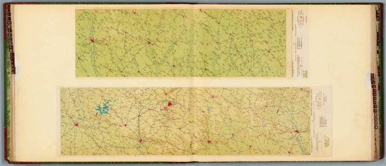
Air navigation map no. 15 (experimental) : Montgomery, Alabama to Augusta, Georgia. Prepared under the direction of the Airways Section Office of the Chief of Air Corps by the Topographic Branch, U.S. Geological Survey. 1926. Engineer Reproduction Plant, U.S. Army, Washington Barracks, D.C. 6572-15. 1926. -- Air navigation map no. 16 (experimental) : Augusta, GA. to Fayetteville, N.C. Compiled and reproduced by the Engineer Reproduction Plant, Corps of Engineers. Under the direction of the Airways Section, Office Chief of Air Corps. 1926. Engineer Reproduction Plant, U.S. Army, Washington Barracks, D.C. 4915. R-1927.
List No
14501.010
Note
Two aeronautical charts representing the areas from Montgomery, Alabama, to Augusta, Georgia, and from Augusta, Georgia, to Fayetteville, North Carolina. Features military, municipal, commercial, emergency, and seaplane landing fields. Also shows political boundaries, roads, railways, cities, towns, topography, bodies of water, shorelines, and drainage. Relief shown with contour lines and color coding. Maps include latitudinal and longitudinal lines, legend, scale statements, and bar scales given in miles, as well as compass roses oriented toward top of sheet (with slight variation between the two maps). Color lithographs. Together, maps are 57 x 102 cm, on double sheet, 60 x 136 cm.
Author
United States. War Department
Full Title
Section of map of parts of Brunswick and New Hanover counties showing the approaches to Wilmington, N.C. Department of Cape Fear, Maj. Gen. W.H.C. Whiting, commanding. Made under the direction of W.H. James, Ch. Eng'r. by B.L. Blackford ... Fort Caswell and adjoining works at western bar Cape Fear, N.C. Evacuated Jan. 16th 1865. Taken possession of ... Jan. 17th 1865. Line of rebel works, Smith's Island, N.C. Evacuated Jan. 16th 1865. Taken possession of ... Jan. 17th 1865. (both) North Atlantic Squadron, Read-Admiral D.D. Porter, commanding. Defenses of Augusta, Ga. From original in possession of Gen. Braxton Bragg, C.S. Army. (with) Fort Johnston, Smithville, N.C. ... (with) Augusta, Ga., 1864. (with) Plan of the fortifications at Columbus, Ga., 1864. (with) Map of the battle-field of Champion's Hill, Miss., May 16, 1863. Engineer's Office, Dept. of the Tenn., Capt. C.B. Comstock, Chief Engr. From surveys by F. Tunica ... and sketches by Brig. Gen. A.P. Hovey and Capt. A. Hickenlooper. Drawn by H.A. Ulffers ... Julius Bien & Co., Lith., N.Y. (1891-1895)
List No
1780.132
Note
Four col. maps with 4 ancillary maps.
1-2 of 2
|