|
Author
Depot General de la Marine
Full Title
Carte Generale De L'Ocean Atlantique ou Occidental
List No
15934.002
Note
Hydrographie Française 1
Author
Pan American World Airways
Full Title
(PAA Route Map.) New York (to) San Juan.
List No
12365.003
Note
Date estimated.
Author
Pan American World Airways
Full Title
PAA Route Map.
List No
12365.006
Note
Date estimated.
Author
[Brault, Louis-Deìsireì-Leìon (1839 - 1885), DÉPÔT DES CARTES ET PLANS DE LA MARINE (FRENCH NAVY)]
Full Title
Type No. 1.; Type No.2. Atlantique Nord. Cartes Types Des Movements Plus Generaux De L'Atmosphere Inferieeure...
List No
15646.002
Note
Date estimated.
Author
[Brault, Louis-Deìsireì-Leìon (1839 - 1885), DÉPÔT DES CARTES ET PLANS DE LA MARINE (FRENCH NAVY)]
Full Title
Type No. 3.; Type No.4. Atlantique Nord. Cartes Types Des Movements Plus Generaux De L'Atmosphere Inferieeure...
List No
15646.003
Note
Date estimated.
Author
[Brault, Louis-Deìsireì-Leìon (1839 - 1885), DÉPÔT DES CARTES ET PLANS DE LA MARINE (FRENCH NAVY)]
Full Title
Janvier. Océan Atlantique Nord / Cartes Mensuelles de la Direction des Vents
List No
15646.004
Note
Date estimated.
Author
[Brault, Louis-Deìsireì-Leìon (1839 - 1885), DÉPÔT DES CARTES ET PLANS DE LA MARINE (FRENCH NAVY)]
Full Title
Fevrier> Océan Atlantique Nord / Cartes Mensuelles de la Direction des Vents
List No
15646.005
Note
Date estimated.
Author
[Brault, Louis-Deìsireì-Leìon (1839 - 1885), DÉPÔT DES CARTES ET PLANS DE LA MARINE (FRENCH NAVY)]
Full Title
Mars. Océan Atlantique Nord / Cartes Mensuelles de la Direction des Vents
List No
15646.006
Note
Date estimated.
Author
[Brault, Louis-Deìsireì-Leìon (1839 - 1885), DÉPÔT DES CARTES ET PLANS DE LA MARINE (FRENCH NAVY)]
Full Title
Avril. Océan Atlantique Nord / Cartes Mensuelles de la Direction des Vents
List No
15646.007
Note
Date estimated.
Author
[Brault, Louis-Deìsireì-Leìon (1839 - 1885), DÉPÔT DES CARTES ET PLANS DE LA MARINE (FRENCH NAVY)]
Full Title
Mai. Océan Atlantique Nord / Cartes Mensuelles de la Direction des Vents
List No
15646.008
Note
Date estimated.
Author
[Brault, Louis-Deìsireì-Leìon (1839 - 1885), DÉPÔT DES CARTES ET PLANS DE LA MARINE (FRENCH NAVY)]
Full Title
Juin. Océan Atlantique Nord / Cartes Mensuelles de la Direction des Vents
List No
15646.009
Note
Date estimated.
Author
[Brault, Louis-Deìsireì-Leìon (1839 - 1885), DÉPÔT DES CARTES ET PLANS DE LA MARINE (FRENCH NAVY)]
Full Title
Juillet. Océan Atlantique Nord / Cartes Mensuelles de la Direction des Vents
List No
15646.010
Note
Date estimated.
Author
[Brault, Louis-Deìsireì-Leìon (1839 - 1885), DÉPÔT DES CARTES ET PLANS DE LA MARINE (FRENCH NAVY)]
Full Title
Aout. Océan Atlantique Nord / Cartes Mensuelles de la Direction des Vents
List No
15646.011
Note
Date estimated.
Author
[Brault, Louis-Deìsireì-Leìon (1839 - 1885), DÉPÔT DES CARTES ET PLANS DE LA MARINE (FRENCH NAVY)]
Full Title
Septembre. Océan Atlantique Nord / Cartes Mensuelles de la Direction des Vents
List No
15646.012
Note
Date estimated.
Author
[Brault, Louis-Deìsireì-Leìon (1839 - 1885), DÉPÔT DES CARTES ET PLANS DE LA MARINE (FRENCH NAVY)]
Full Title
Octobre. Océan Atlantique Nord / Cartes Mensuelles de la Direction des Vents
List No
15646.013
Note
Date estimated.
Author
[Brault, Louis-Deìsireì-Leìon (1839 - 1885), DÉPÔT DES CARTES ET PLANS DE LA MARINE (FRENCH NAVY)]
Full Title
Novembre. Océan Atlantique Nord / Cartes Mensuelles de la Direction des Vents
List No
15646.014
Note
Date estimated.
Author
[Brault, Louis-Deìsireì-Leìon (1839 - 1885), DÉPÔT DES CARTES ET PLANS DE LA MARINE (FRENCH NAVY)]
Full Title
Decmbre. Océan Atlantique Nord / Cartes Mensuelles de la Direction des Vents
List No
15646.015
Note
Date estimated.
Author
[Bonner, Mary Graham, 1890-1974, Price, Luxor]
Full Title
"I'm the Guld Stream. Have you ever heard of me?" Luxor Price. (to accompany) The Magic Map, by Mary Graham Bonner, Illustrated by Luxor Price. New York, the Macaulay Company. Copyright, 1927.
List No
11562.019
Note
Color pictorial map, showing the North Atlantic currents with its northern extension towards Europe.
Author
Western Union
Full Title
Western Union Trans-Atlantic Cables and Connections. The Fast Route to America.
List No
15456.000
Note
Date estimated.
Author
[U.S. Coast and Geodetic Survey, U.S. Army Air Forces]
Full Title
Azores
List No
15328.007
Author
[U.S. Coast and Geodetic Survey, U.S. Army Air Forces]
Full Title
Cape Verde Islands
List No
15328.014
Author
Monte (Monti), Urbano, 1544-1613
Full Title
Tavola XXIIII. Che Ha Sua Superiore La Tavola. XII. Libro Terzo.
List No
10130.026
Author
La Condamine, Charles-Marie de, 1701-1774
Full Title
Carte des routes de Mr. de la Condamine tant par Mer que par Terre dans le cours du Voyage à l'Equateur : Par le Sr. d'Anville. Gravé par G. Delahaye.
List No
14377.006
Note
Map of the Atlantic Ocean showing Condamine's routes both by sea and land during the Voyage to the Equator. Shows routes, topography, drainage, coastlines, islands and shoals. Relief shown pictorially. Includes latitudinal and longitudinal lines, as well as explanatory notes. Black and white engraving. Map is 17 x 20 cm, on fold-out sheet 25 x 40 cm. With handwritten annotations in pencil at bottom margin. Appears in first part of volume.
Author
[3, Soviet Union. Glavnoe upravlenie geodezii i kartografii]
Full Title
Атлантический Океан = Atlanticheskiy Okean. 278-279. Atlas Mira : 1954.
List No
13682.292
Note
Map of the Atlantic Ocean. Showing ocean currents, shipping and exploration routes. Relief shown by gradient tints and spot heights. Depths shown by bathymetric tints, isolines and soundings.
Author
Wyld, James, 1812-1887
Full Title
The Atlantic Steam Packet Chart Shewing The Line Of Communication With North America And The West Indies &c. &c. By James Wyld Geographer To The Queen And Late H.R.H. Prince Albert. London, Published by Jas. Wyld ... Charing Cross East.
List No
3140.002
Note
Date estimated.
Author
[Brault, Louis-Deìsireì-Leìon (1839 - 1885), Depot de la Marine]
Full Title
Octobre, Novembre, Decembre. Atlantique Sud - Cartes De La Direction Et De L'Intensite Probables Des Vents Par L. Brault . . . 1876
List No
15038.000
Author
Henze, Adolf
Full Title
Section 20 Henze's Erd-Globus.
List No
10681.021
Note
With a diameter of 43 inches, these 24 gores form the largest printed globe produced in the 19th century.Dimensions are sheet size.
Author
Henze, Adolf
Full Title
Section 24 Henze's Erd-Globus.
List No
10681.024
Note
With a diameter of 43 inches, these 24 gores form the largest printed globe produced in the 19th century.Dimensions are sheet size.
Author
Mercier, Jacques
Full Title
Le front de l'Ocean. Jac Mercier. dessinateur.
List No
13400.000
Note
Dated 31-3-42
Author
Philip, George
Full Title
The North Atlantic Ocean. George Philip & Son, Ltd. The London Geographical Institute. (to accompany) Philips' Mercantile Marine Atlas. Second Edition ... 1905. (insets) Magnetic parallels and meridians. (with) Variation of the compass, isogonic lines.
List No
0724.010
Note
Double page colored map, with 2 insets of parts of West Africa. Shows political divisions, towns, populations, mail routes, steamship routes, distances, principal railways, telegraph cables, navigable waters, canals, lighthouses, harbors, British and American consular offices, naval stations, dockyards, etc. Depth shown by gradient tints and soundings. Includes reference to general map.
Author
Halley, Edmund
Full Title
The New and Correct Chart of the Western and Southern Oceans.
List No
12434.002
Note
Foldout. This is a corrected edition of Edmund Halley's landmark 1701 chart with the same title. Peter Barbour hailed that chart as the "most significant cartographic achievement of Williamite England" (The Age of William III & Mary II, plate 106.) It was one of the earliest thematic maps, and the first to show lines of equal magnetic variation which was an important advance for navigation. A version of Halley's chart was added to the Fourth Book in 1721, but was discontinued in favor of this revised version in 1749. As noted in the flanking text, there is a "perpetual though slow Change in the Variation almost everywhere, which as made it necessary to construct [the chart] anew from accurate Observations, made by the most ingenious Navigators."
Author
Mount and Davidson
Full Title
A New Generall Chart for the West Indies of E. Wright's Projection.
List No
12434.007
Author
[Humboldt, Alexander von, 1769-1859, Bonpland, Aime, Michaelis, H.]
Full Title
XXXIII. Le Nouveau Continent Figure dans la Mappemonde de Juan de la Cosa en 1500.
List No
12125.055
Author
Jansson, Johannes, 1588-1664
Full Title
Mar del Nort.
List No
10056.007
Author
Boucher, Lucien
Full Title
Christopher Colombus 1436-1506.
List No
12054.009
Author
Boucher, Lucien
Full Title
Marquis de La Fayette, 1757-1834.
List No
12054.010
Author
Boucher, Lucien
Full Title
Le General Pershing, 1917.
List No
12054.011
Author
Boucher, Lucien
Full Title
Charles A. Lindbergh, 21 May, 1927.
List No
12054.012
Author
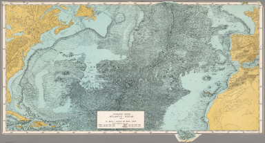
[Heezen, Bruce C., Tharp, Marie]
Full Title
Physiographic Diagram, Atlantic Ocean (Sheet 1).
List No
6368.000
Note
Date from WorldCat. Color.
Author
Smiley, Thomas T.
Full Title
Atlantic Ocean.
List No
0902.001
Note
In full color. The map of the Atlantic Ocean includes a vignette of the landing of Columbus.
Author
Popple, Henry
Full Title
A Map of the British Empire in America with the French and Spanish Settlements adjacent thereto. by Henry Popple. (Sheet 8).
List No
2874.010
Note
Large map includes the Grand Fishing Bank of New-found Land complete with soundings. Three inset maps are included: The Harbour of Placentia, The Harbour of Anapolis Royal, and Boston Harbour. All include scale, and the last two include soundings. Uncolored.
Author
Popple, Henry
Full Title
A Map of the British Empire in America with the French and Spanish Settlements adjacent thereto. by Henry Popple. (Sheet 11).
List No
2874.013
Note
The only land shown on this part of the Atlantic is Bermuda. Uncolored.
Author
Popple, Henry
Full Title
A Map of the British Empire in America with the French and Spanish Settlements adjacent thereto. by Henry Popple. (Sheet 12).
List No
2874.014
Note
Far right extent of map includes five inset maps: New York and Perth Amboy Harbours, The Town and Harbour of Charles Town in South Carolina, The Bermuda or Summer Islands, Harbour of St. Augustine, and The Harbour of Providence. Soundings often included. Uncolored.
Author
Fitch, George W.
Full Title
Atlantic Ocean. Drawn by (to be filled in. By George W. Fitch. New York: Sheldon, Blakeman and Company, 115 Nassau Street. Entered ... 1850, by Huntington and Savage ... New York)
List No
0289.013
Note
Printed map form with title, grid lines and numbers or "mapping plate." The mapping has not been added. Prime meridians: Greenwich and Washington.
Author
Johnston, Alexander Keith, 1804-1871
Full Title
Physical chart of the Atlantic Ocean showing the form & direction of the currents; distribution of heat at the surface, navigation & trade routes, banks, rocks &c. by A.K. Johnston, F.R.S.E. Engraved by W. & A.K. Johnston. William Blackwood & Sons, Edinburgh & London. (1856)
List No
0372.013
Note
Hand col. lithograph. Soundings in fathoms. Includes inset map, "Table of the velocity of the Gulf Stream," and "Table of the comparative mean velocity of the currents within 24 hours." "Hydrology no. 1."
Author
Johnston, Alexander Keith, 1804-1871
Full Title
Physical Chart of the Atlantic Ocean.
List No
0372AM
Author
Johnston, Alexander Keith, 1804-1871
Full Title
Physical Chart of the Atlantic Ocean. (continued)
List No
0372AN
Note
Includes Chart of the Basin of the Atlantic Ocean at 1:3,800,000, and a Vertical Section of the North Atlantic Ocean.
Author
Johnston, Alexander Keith, 1804-1871
Full Title
Physical Chart of the Atlantic Ocean. (continued)
List No
0372AO
Note
Includes General Sketch-Chart of the Oceanic Currents.
Author
[Forbes, Edward, 1815-1854, Johnston, Alexander Keith, 1804-1871]
Full Title
Map of the distribution of marine life, illustrated chiefly by fishes, Molluscs & Radiata; showing also the extent & limits of the Homoiozoic belts, now first laid down for Keith Johnston's Physical atlas by Professor Edward Forbes, F.R.S., of Kings College, London & the Government School of Mines, President of the Geological Society. Engraved & printed in colours by W. & A.K. Johnston, Edinr. William Blackwood & Sons, Edinburgh & London. 1st March 1854, (1856)
List No
0372.032
Note
Col. lithographed map. Includes map "Colonization of British Seas illustrated by Mollusca & Radiata," "Diagram illustrating generic centres," "Diagram of zones of depth," and graph "Comparative extent of regions of depth in the Aegean Sea." "Phytology & zoology no. 8."
Author
Johnston, Alexander Keith, 1804-1871
Full Title
Basin of the North Atlantic Ocean, by Keith Johnston, F.R.S.E. Engraved & printed by W. & A.K. Johnston, Edinburgh. William Blackwood & Sons, Edinburgh & London, (1861)
List No
0373.004
Note
Engraved map. Continental boundaries hand col. Relief shown by hachures. Shows currents, etc. "Keith Johnston's general atlas 4."
|