|
REFINE
Browse All : Images of Atlanta (Ga.)
1-28 of 28
Author
[Ford Motor Company, Geological Survey (U.S.). Topographic Branch, United States. Army. Air Corps]
Full Title
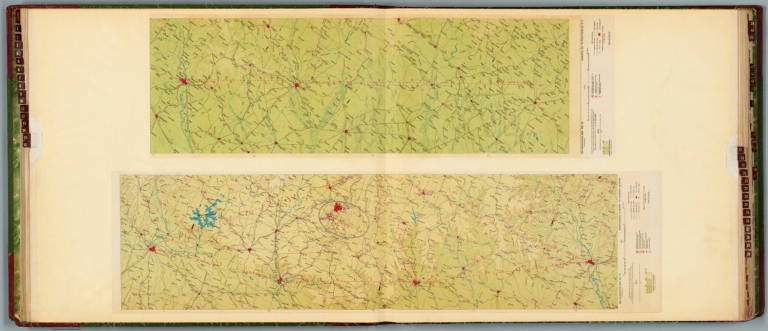
Air navigation map no. 15 (experimental) : Montgomery, Alabama to Augusta, Georgia. Prepared under the direction of the Airways Section Office of the Chief of Air Corps by the Topographic Branch, U.S. Geological Survey. 1926. Engineer Reproduction Plant, U.S. Army, Washington Barracks, D.C. 6572-15. 1926. -- Air navigation map no. 16 (experimental) : Augusta, GA. to Fayetteville, N.C. Compiled and reproduced by the Engineer Reproduction Plant, Corps of Engineers. Under the direction of the Airways Section, Office Chief of Air Corps. 1926. Engineer Reproduction Plant, U.S. Army, Washington Barracks, D.C. 4915. R-1927.
List No
14501.010
Note
Two aeronautical charts representing the areas from Montgomery, Alabama, to Augusta, Georgia, and from Augusta, Georgia, to Fayetteville, North Carolina. Features military, municipal, commercial, emergency, and seaplane landing fields. Also shows political boundaries, roads, railways, cities, towns, topography, bodies of water, shorelines, and drainage. Relief shown with contour lines and color coding. Maps include latitudinal and longitudinal lines, legend, scale statements, and bar scales given in miles, as well as compass roses oriented toward top of sheet (with slight variation between the two maps). Color lithographs. Together, maps are 57 x 102 cm, on double sheet, 60 x 136 cm.
Author
[Ford Motor Company, U.S. Coast and Geodetic Survey]
Full Title
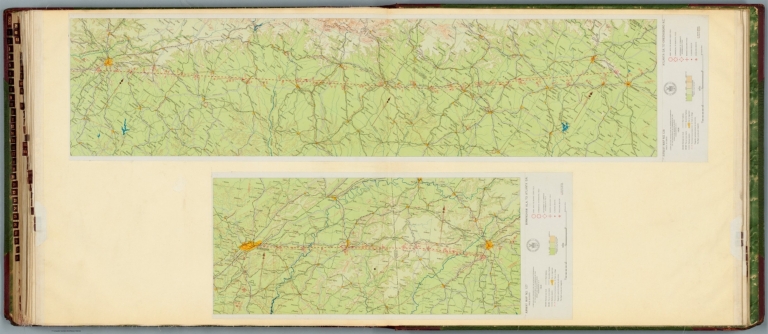
Airway map no. 127 : Birmingham Ala. to Atlanta Ga. Compiled and printed for the Aeronautics Branch of the Department of Commerce by the Coast and Geodetic Survey, Washington, D.C. 1929. -- Airway map no. 128 : Atlanta Ga. to Greensboro N.C. Compiled and printed for the Aeronautics Branch of the Department of Commerce by the Coast and Geodetic Survey, Washington, D.C. 1929.
List No
14501.038
Note
Two aeronautical charts representing the areas from Birmingham, Alabama, to Atlanta, Georgia, and from Atlanta to Greensboro, North Carolina. Features military, municipal, and commercial landing fields, seaplane anchorage and beacons. Also shows political boundaries, roads, railways, cities, towns, topography, bodies of water, and drainage. Relief shown with contour lines and color coding. Maps include latitudinal and longitudinal lines, legend, scale statements, and bar scales given in miles, as well as compass roses oriented toward top of sheet (with slight variation between the two maps). With the seal of the Department of Commerce, United States of America. Color lithographs. Together, maps are 56 x 120 cm, on double sheet, 60 x 135 cm.
Author
Mitchell, Samuel Augustus
Full Title
County map of the states of Georgia and Alabama. (with) Savannah, Georgia. (with) City of Atlanta, the capitol of Georgia. Entered ... 1879 by S. Augustus Mitchell ... Washington. (1880)
List No
0586.024
Note
Hand colored with 2 insets. Shows settlements, railroads, rivers, etc. Prime meridians: Greenwich and Washington.
Author
Mitchell, Samuel Augustus Jr.
Full Title
County map of the states of Georgia and Alabama. (with) Savannah, Georgia. (with) City of Atlanta, the capitol of Georgia. Copyright by S. Augustus Mitchell 1884.
List No
0592.026
Note
Hand colored with 2 insets. Shows settlements, railroads, rivers, etc. Prime meridians: Greenwich and Washington.
Full Title
County map of the states of Georgia and Alabama. (with) Savannah, Georgia. (with) City of Atlanta, the capitol of Georgia. Copyright 1887 by Wm. M. Bradley & Bro. (1890)
List No
0594.025
Note
Hand colored with 2 insets. Shows settlements, railroads, rivers, etc. Prime meridians: Greenwich and Washington.
Author
[Passonneau, Joseph R., Wurman, Richard Saul]
Full Title
Atlanta.
List No
10195.014
Author
[Passonneau, Joseph R., Wurman, Richard Saul]
Full Title
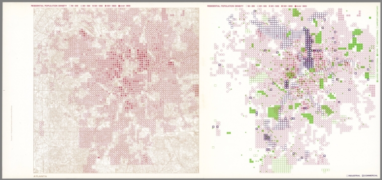
Atlanta. Residential Population Density; Industrial, Commercial; Large Institutional, Park, Institutional, Airport, Cemetery.
List No
10195.015
Author
[Passonneau, Joseph R., Wurman, Richard Saul]
Full Title
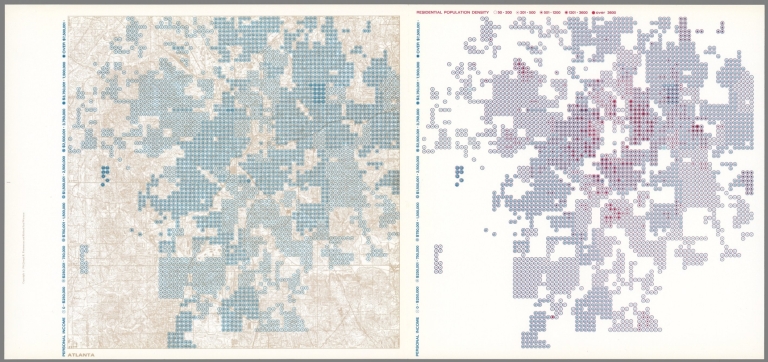
Atlanta. Personal Income; Residential Population Density.
List No
10195.016
Author
[Nirenstein, Nathan, Funk & Wagnalls Company.]
Full Title
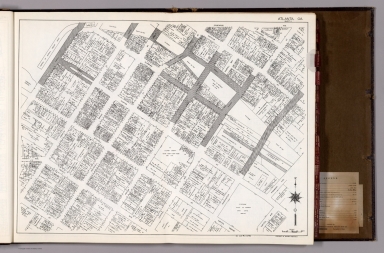
(One Hundred Per Cent Business Real Estate Locations), Atlanta (Georgia). (Sheet 1).
List No
12508.009
Author
[Nirenstein, Nathan, Funk & Wagnalls Company.]
Full Title
(One Hundred Per Cent Business Real Estate Locations), Atlanta (Georgia). (Sheet 2).
List No
12508.010
Author
[Nirenstein, Nathan, Funk & Wagnalls Company.]
Full Title
(Composite map of) (One Hundred Per Cent Business Real Estate Locations), Atlanta (Georgia). (Sheets 1 and 2).
List No
12508.011
Author
Rand McNalley & Company
Full Title
Atlanta, Ga. -- Albanay, N.Y. -- Atlantic City, N. J. -- Baltimore, Md. -- Birmingham, Ala. -- Boston, Mass., and vicinity -- Buffalo, N.Y., and vicinity.
List No
14003.054
Note
7 road maps of cities. Maps include compass roses and legends. Copyright by Rand McNally & Company, Chicago, Ill. Lithographed in the U.S.A.
Author
Cram, George Franklin, 1841-1928
Full Title
Atlanta.
List No
14372.299
Note
Map of Atlanta, Georgia. Shows political boundaries, railroads, streets, bridges, parks, bodies of water and drainage. Includes a legend, as well a a circle indicating city limits. Colored lithograph. Map is 30 x 24 cm, on sheet 45 x 33 cm.
Author
[Bush, H. M., United States. War Department]
Full Title
Map of the country between Vicksburg and Meridian, Miss. showing the route followed by the Seventeenth Army Corps under the command of Maj. Gen. J.B. McPherson in February, 1864. Surveyed by Lt. H.M. Bush and assistants S. Davis and S.W. Dunning under the direction of Capt. A. Hickenlooper, Chf. Engr. (with) Sketch of the city of Atlanta and line of defenses. L.P. Grant, Capt. Engs. (with) Sketch of battery. L.P. Grant, Capt. Engs. (with) Map of Smith's Island, N.C. Prepared under the direction of Capt. Wm. H. James, Chf. Engr. by Lieut. B.L. Blackford, Top. Engr., Nov., 1863. Accompanying letter of Maj. Gen. W.H.C. Whiting, C.S. Army. Julius Bien & Co., Lith., N.Y. (1891-1895)
List No
1780.051
Note
Col. map with 3 ancillary maps. Relief shown by hachures.
Author
United States. War Department
Full Title
Capitol, Richmond, Va. Front view taken May 1865. Libby Prison, north side. Taken May 1865. Libby Prison, south side, taken May 1865. (with) Post Hospital, City Point, Va., 1865. Rebel Fort, now Federal No. 7 of new lines, Atlanta Ga. (with) Federal Fort No. 7, Atlanta, Ga. New line of defenses looking towards No. 8. Federal Fort No. 8, Atlanta, Ga. New line of defenses looking towards No. 7. Federal Fort No. 9, Atlanta, Ga, new line of defenses ... (with) Federal Fort No. 10, Atlanta, Ga. New line of defenses looking toward No. 9. (with) Federal Fort No. 10, Atlanta, Ga. New line of defenses, looking east ... (with) Federal Fort No. 11, Atlanta, Ga. New line of defenses, looking towards No. 10. Julius Bien & Co., Lith., N.Y. (1891-1895)
List No
1780.126
Note
Eleven sepia-toned lithographs. Some from original photographs in the Office of the Quartermaster General, U.S. Army; some accompany report of Capt. O.M. Poe.
Author
United States. War Department
Full Title
Federal Fort No. 11, Atlanta, Ga. ... looking toward No. 12. Federal Fort No. 12 ... looking towards City Hall ... Federal Fort No. 12 ... looking towards No. 11. Federal Fort No. 13 ... Federal Fort No. 19 ... looking north. Federal Fort No. 19 ... looking south. Rebel fort, south of Chattanooga R.R., Atlanta, Ga. Rebel fort, Atlanta, Ga. between Peach Tree Street and Chattanooga Railroad. Rebel fort on Chattanooga R.R., Atlanta, Ga., Potter's House. Rebel fort on Peach Tree Street, Atlanta, Ca. Casemated battery on salient of rebel line, near White Hall, looking north towards Chattanooga R.R., 2 miles S.W. of Atlanta, Ga. Rebel battery, Peach Tree Street, Atlanta, Ga. Julius Bien & Co., Lith., N.Y. (1891-1895)
List No
1780.127
Note
Twelve sepia-toned lithographs. Accompany report of Capt. O.M. Poe.
Author
United States. War Department
Full Title
Rebel lines, Atlanta, Ga. south of Chattanooga R.R. with Federal Fort No. 7. Rebel lines near Chattanooga Railroad ... showing battery silenced by our fire. Rebel line near Chattanooga Railroad ... looking across R.R. towards the south. Rebel lines near Chattanooga Railroad ... looking across Rail Road to the southwest ... Rebel lines near Chattanooga Railroad ... showing nature of obstructions. Rebel lines from Chattanooga Railroad ... Rebel lines, north side of Atlanta, Ga. Rebel lines, north side of Atlanta, Ga. between Peach Tree Street and Chattanooga Rail Road. Rebel lines east of Atlanta, Ga. looking toward Decatur. Rebel lines south-east of Atlanta, Ga., looking towards Augusta R.R. Rebel lines south-east of Atlanta, Ga. looking towards McPherson's battle-ground of July 22d. Rebel lines south-east of Atlanta, Ga. Julius Bien & Co., Lith., N.Y. (1891-1895)
List No
1780.128
Note
Twelve sepia-toned lithographs. Accompany report of Capt. O.M. Poe.
Author
United States. War Department
Full Title
Position of iron clads, January 15th, 1865. Engine "Hero" destroyed partially by rebels when avacuating (sic) Atlanta, Ga. (with) Rebel lines, Atlanta, Ga. looking across Augusta R.R. to the southward. (with) Rebel line on Augusta R.R. ... looking south. (with) Rebel lines on west side of Atlanta, Ga. looking southward. (with) Rebel lines, Atlanta, Ga. (with) U.S. Rolling Mill at Chattanooga, Tenn. (with) Ruins of rolling mill and cars destroyed by rebels on evacuation of Atlanta, Ga. (with) Round-house, Chattanooga R.R. at Atlanta, Ga. (with) Potter House, Atlanta, Ga. showing effects of bombardment. Julius Bien & Co., Lith., N.Y. (1891-1895)
List No
1780.129
Note
Ten sepia-toned lithographs. Some accompany report of Capt. O.M. Poe. U.S. Rolling Mill from original photograph in Office of the Chief of Engineers, U.S. Army. Iron clads from original in archives of the U.S. Coast Survey. Ships shown: Minnesota, Wabash, Mahopac, Canonicus, Iron Sides, Monadnock, Saugus, Malvern and Brooklyn.
Author
[Cram, George Franklin, Murray-Aaron, Eugene, 1852-1941.]
Full Title
Atlanta. Published by George F. Cram, Chicago, Ill. (to accompany) Cram's atlas of the world, ancient and modern : new census edition -- indexed.
List No
1910.092
Note
Color map. Shows city blocks, roads, railroads, river, public buildings, parks, etc.
Author
Cram, George Franklin
Full Title
Atlanta. South America.
List No
2809.118
Note
Border of map has a table of cities and populations, keyed to map. Relief shown by hachures. Prime meridians Washington D.C. and Greenwich. Scale of South America map is 1:17,882,000.
Author
Poe, Orlando M.
Full Title
Map illustrating the Siege of Atlanta, Ga. by the U.S. Forces, under Command of Maj. Gen. W.T. Sherman from the passage of Peach Tree Creek, July 19th 1864 to the commencement of the movement upon the Enemy's Lines of communication south of Atlanta, August 26, 1864 ... Reduced and engraved in the Engineers Bureau, War Dept. from an original prepared under the directions of Cap. O.M. Poe, Corps of Engs. and Senr. Engr. on Genl Sherman's Staff. Edw. Molitor, Lith.
List No
3856.000
Note
Separate issue on heavy paper, shows positions of Union and Rebel forces around the city: "The red Figures indicate the surface elevation at these points, above the plane of reference, which is taken at 50 ft below the Water-table of the City Hall." Plate 88:1 in "Atlas to Accompany..."
Author
Cram, George Franklin
Full Title
Atlanta.
List No
4727.084
Note
With printed color.
Author
Mitchell, Samuel Augustus Jr.
Full Title
County Map of the States of Georgia and Alabama. (insets) Savannah, Georgia. City of Atlanta, the Capitol of Georgia. Entered ... 1874 by S. Augustus Mitchell ... Washington.
List No
5041.026
Note
Prime meridians are Washington D.C. and Greenwich.
Author
U.S. War Department, Chief of Engineers
Full Title
Map IV illustrating the Military Operations of the Atlanta Campaign. Embracing the region from Pine, Lost and Kennesaw Mountains south to include Atlanta, and its environs, exhibiting the lines of operations at Pine, Lost and Kennesaw Mts., at Smyrna Camp Ground, along the Chattahoochie river, and the investment of Atlanta. 1864. Maj. Genl. W.T. Sherman ... Genl. J.E. Johnston and J.B. Hood ... Compiled by Authority of the Secretary Of War ... 1874. Authorities Surveys made by J.T. Dodge and H.H. Ruger ... under the direction of Captain O.M. Poe ... Am. Photo-Lithographic Co. N.Y. (Osborne's Process.)
List No
5339.000
Note
Map four. Colored in blue lines to indicate to indicate Union Forces and red lines to indicate Confederate Forces.
Author
U.S. War Department, Chief of Engineers
Full Title
Map V illustrating the Military Operations of the Atlanta Campaign. This map includes the region from the Chattahoochee River south to Jonesboro and Lovejoy's Station, and exhibits the Works of the United States and Confederate Forces. 1864. Maj. Genl. W.T. Sherman ... Genl. J.E. Johnston and J.B. Hood ... Compiled by Authority of the Hon. The Secretary Of War ... 1877. Authorities. Surveys made by J.T. Dodge & Edw. Ruger ... under the direction of Major O.M. Poe ... Am. Photo-Lithographic Co. N.Y. (Osborne's Process.)
List No
5340.000
Note
Map five of the series. Colored in blue lines to indicate to indicate Union Forces and red lines to indicate Confederate Forces.
Full Title
County map of the states of Georgia and Alabama. (with) Savannah, Georgia. (with) City of Atlanta, the capitol of Georgia. Copyright 1886 by Wm. M. Bradley & Bro.
List No
5784.025
Note
Hand colored with 2 insets. Shows settlements, railroads, rivers, etc. Prime meridians: Greenwich and Washington.
Author
Shell Oil Company
Full Title
Shell Street Guide and Metropolitan Map Atlanta (cover title). Shell Street Map of Atlanta. 12-DD-1956-1. (inset) Downtown Atlanta.
List No
5840.111
Author
Curtis Publishing Company
Full Title
Atlanta.
List No
9687.012
1-28 of 28
|