|
Author
[Diercke, Carl, Gaebler, Eduard]
Full Title
Asien. (to accompany) Diercke Schul-Atlas fur hohere Lehranstalten. "6" on the lower right margin.
List No
0243.021
Note
Two color maps. Shows coastal and marine areas, and vegetation, and animal life areas in Asia. Prime meridian is Greenwich.
Author
[Diercke, Carl, Gaebler, Eduard]
Full Title
Asien. Diercke u. Gaebler, Schulatlas fur hohere Lehranstalten.
List No
0243.022
Note
Color map on 2 pages. Relief shown by hacures and spot heights. Prime meridian is Greenwich.
Author
[Diercke, Carl, Gaebler, Eduard]
Full Title
Asien. Temperaturkarte. Regenkarte. Verbreitung der wichtigsten pflanzen. (to accompany) Diercke Schul-Atlas fur hohere Lehranstalten. (with insets). "7" on the lower right margin.
List No
0243.023
Note
Three color maps with 4 insets on 2 pages. Shows temperature, rainfall, and dissemination of key plant. Relief shown by hachures and spot heights. Prime meridian is Greenwich.
Author
[Diercke, Carl, Gaebler, Eduard]
Full Title
Asien, staatenkarte. Diercke u. Gaebler, Schulatlas fur hohere Lehranstalten.
List No
0243.024
Note
Color map on 2 pages. Shows administrative boundaries. Relief shown by hachures. Prime meridian is Greenwich.
Author
[Diercke, Carl, Gaebler, Eduard]
Full Title
Asien, Religionskarte. (to accompany) Diercke Schul-Atlas fur hohere Lehranstalten. (with four insets).
List No
0243.025
Note
Color map, with 4 insets: Jerusalem, Nazareth, and Sinai. Shows dissemination of religions. Relief shown by hachures. Prime meridian is Greenwich.
Author
[Diercke, Carl, Gaebler, Eduard]
Full Title
Vorder-Asien. Diercke u. Gaebler, Schulatlas fur hohere Lehranstalten. Druck und Verlag : Braunschweig, George Westermann.
List No
0243.027
Note
Color map. Shows roads and railroads. Relief shown by hachures. Prime meridian is Greenwich.
Author
[Diercke, Carl, Gaebler, Eduard]
Full Title
Asien. Volkerkarte. Asien.Bevolkerungsdichte und wichtige Verkehrswege. (to accompany) Diercke Schul-Atlas fur hohere Lehranstalten. (with 4 insets). "9" on the lower right margin.
List No
0243.028
Note
Two color maps and 8 insets on 2 pages. Insets: Chiwa, Gangesdelta, Straase Bad-el-Mandeb, Strasse von Malaka, Bombay ... , Kanton ..., Peking ..., Tokio ... Maps showing international boundaries and population density and major transportation routes. Relief shown by hachures. Prime meridian is Greenwich.
Author
[Diercke, Carl, Gaebler, Eduard]
Full Title
Hinter-Asien. Diercke u. Gaebler, Schulatlas fur hohere Lehranstalten. Druck und Verlag : Braunschweig, George Westermann.
List No
0243.029
Note
Color map. Relief shown by hachures. Prime meridian is Greenwich.
Author
[Dower, John, Higgins, W.M.]
Full Title
Asia.
List No
0247.079
Author
Finley, Anthony
Full Title
Asia. Young & Delleker Sc. Published by A. Finley, Philada. (to accompany) A New General Atlas Comprising a Complete Set of Maps, representing the Grand Divisions Of The Globe ... Philadelphia: Published by Anthony Finley. 1827.
List No
0282.055
Note
Full color map on sheet 35x27. Relief shown pictorially. Prime meridians are Washington and Greenwich. Shows political divisions, major cities, deserts and rivers.
Author
Finley, Anthony
Full Title
Russia In Asia. Young & Delleker Sc. Published by A. Finley, Philada. (to accompany) A New General Atlas Comprising a Complete Set of Maps, representing the Grand Divisions Of The Globe ... Philadelphia: Published by Anthony Finley. 1827.
List No
0282.056
Note
Full color map on sheet 35x27. Covers from the Black Sea and Arabia east to the Behring Strait, north to the Arctic, and south to Chinese Tartary. Relief shown pictorially. Prime meridians are Washington and Greenwich. Shows major cities, forests and rivers.
Author
Finley, Anthony
Full Title
Turkey In Asia. Young & Delleker Sc. Published by A. Finley, Philada. (to accompany) A New General Atlas Comprising a Complete Set of Maps, representing the Grand Divisions Of The Globe ... Philadelphia: Published by Anthony Finley. 1827.
List No
0282.057
Note
Full color map on sheet 35x27. Covers Georgia, Iraq, Lebanon, Syria, Jordan, Cyprus, Palestine and Israel. Relief shown pictorially. Prime meridians are Washington and Greenwich. Shows boundary between Europe and Asia, major cities, lakes and rivers.
Author
Finley, Anthony
Full Title
Hindoostan. Young & Delleker Sc. Published by A. Finley, Philada. (to accompany) A New General Atlas Comprising a Complete Set of Maps, representing the Grand Divisions Of The Globe ... Philadelphia: Published by Anthony Finley. 1827.
List No
0282.058
Note
Full color map on sheet 35x27. Relief shown pictorially. Prime meridians are Washington and Greenwich. Shows administrative divisions, major cities and rivers.
Author
Finley, Anthony
Full Title
China. Young & Delleker Sc. Published by A. Finley, Philada. (to accompany) A New General Atlas Comprising a Complete Set of Maps, representing the Grand Divisions Of The Globe ... Philadelphia: Published by Anthony Finley. 1827.
List No
0282.059
Note
Full color map on sheet 35x27. Relief shown pictorially. Prime meridians are Washington and Greenwich. Shows administrative divisions, major cities and rivers.
Author
Finley, Anthony
Full Title
Palestine. Young & Delleker Sc. Published by A. Finley, Philada. (to accompany) A New General Atlas Comprising a Complete Set of Maps, representing the Grand Divisions Of The Globe ... Philadelphia: Published by Anthony Finley. 1827.
List No
0282.060
Note
Full color map of Palestine, Israel or the Holy Land. Covers the region from Sidon and Damascus in the north to the southern tip of the Dead Sea or Zoar. Divided with color coding according to the Biblical tribes of Israel. Includes explanation. Relief shown pictorially. Prime meridians are Washington and Greenwich. Shows cities, river systems, deserts and mountains.
Author
Finley, Anthony
Full Title
Asia. Published by A. Finley Philada. Young & Delleker Sc.
List No
0285.052
Note
Full color by country.
Author
Finley, Anthony
Full Title
Terra Veteribus Nota. Thackara Sculpt. Published by A. Finley Philada. 1827.
List No
0285.063
Note
In full color by area.
Author
Finley, Anthony
Full Title
Orientis Tabula. J. Vallance fc. Published by A. Finley Philada. 1827.
List No
0285.065
Note
Regions in full color.
Author
Finley, Anthony
Full Title
Asia Minor Antiqua. P.E. Hamm Sc. Published by A. Finley Philada. 1827.
List No
0285.066
Note
In full color by region.
Author
Finley, Anthony
Full Title
State of Nations at the Christian aera From Pinkerton on the Goths. Published by A. Finley Philada. 1827.
List No
0285.071
Note
In two color with a dividing line stating: "On the north of the Line the Ancients placed the Scythic Ocean: on the East, the Eoan."
Author
Finley, Anthony
Full Title
An Historical Chart representing in a Chronological Series the Rise Revolutions & Fall of the principal Empires of the World ... J. Vallance fc. Published by A. Finley Philada. 1827. (with) inset map of Romani Imperii &c Typus.
List No
0285.072
Note
Detailed full color chart showing the history of the Empires from 2300 B.C. to 1800 A.D. Small map is also in full color. Chart has lengthy explanation included.
Author
[Fitch, George W., Lampson, Mary E.]
Full Title
Asia. Drawn by (to be filled in. By George W. Fitch. New York: Sheldon, Blakeman and Company, 115 Nassau Street. Entered ... 1850, by Huntington and Savage ... New York)
List No
0289.012
Note
Printed map form with title, grid lines and numbers or "mapping plate." Map data added including relief by hachures in pen-and-ink by Mary E. Lampson. Prime meridians: Greenwich and Washington.
Author
[Gaultier, abbe (Aloisius Edouard Camille), 1746?-1818, Wauthier, J. M.]
Full Title
A plain map of Asia, according to the method of the Abbe Gaultier. By Mr. Wauthier, his pupil, 1797.
List No
0294.007
Note
Engraved map. Hand colored. Relief shown pictorially. Outline map showing unnamed countries, rivers, mountains, cities, etc. Prime meridian: Ferro.
Author
[Gaultier, abbe (Aloisius Edouard Camille), 1746?-1818, Wauthier, J. M.]
Full Title
A map of Asia according to the method of the Abbe Gaultier. By Mr. Wauthier, his pupil, 1799.
List No
0294.008
Note
Engraved map. Hand colored. Relief shown pictorially. Shows countries, rivers, mountains, cities, water bodies, etc. Prime meridian: Ferro.
Author
[Bowen, Emanuel, Gibson, John]
Full Title
Asia. (to accompany) Atlas Minimus or a New Set of Pocket Maps of the Several Empires, Kingdoms and States of the Known World, with Historical Extracts relative to each. Drawn and Engraved by J. Gibson from the Best Authorities, Revis'd, Corrected and Improv'd by Eman: Bowen Geographer to His Majesty.
List No
0300.007
Note
First edition. The "Historical Extracts" are short bits of text printed on the maps giving relevant geographical information. A revised edition was published in London in 1792. In 1759, another edition was published adding separate geographical descriptions and correcting some of the maps (see our copy). The Philadelphia 1798 edition by Mathew Carey incorporates the 1759 edition text word for word (excepting the maps of United States which Carey omits in favor of his pocket atlas of the U.S.). Gibson and Bowen made the four sheet map of North America (Stevens 49), and Gibson made the four sheet map of America (Stevens 3).
Author
Gray, O.W.
Full Title
Gray's Atlas Map of Asia.
List No
0310.027
Author
Gray, O.W.
Full Title
Asia.
List No
0312.074
Full Title
Asia. J.H. Young Sc. (Philadelphia: John Grigg, No. 9 North Fourth Street. 1830)
List No
0315.018
Note
Engraved map. Full hand color. Relief shown pictorially. Prime meridians: Greenwich and Washington.
Author
Johnson, A.J.
Full Title
Johnson's Asia By Johnson And Ward.
List No
0352.061
Note
Full color map. With heavy outline color. Shows cities and towns, rivers and roads. Relief shown by hachures. Prime meridians are Greenwich and Washington D.C.
Author
Johnson, A.J.
Full Title
Johnson's Asia. Entered ... 1867.
List No
0358.064
Author
Johnston, Alexander Keith
Full Title
The Mountains, Table Lands, Plains & Valleys of Asia ....
List No
0370.014
Author
Johnston, Alexander Keith, 1804-1871
Full Title
The physical features of Europe & Asia, showing the mountains, table-lands, plains & slopes. By A.K. Johnston, F.R.S.E. Engraved by W. & A.K. Johnston. William Blackwood & Sons, Edinburgh & London, (1856)
List No
0372.002
Note
Hand col. lithographed map. Relief shown by hachures. Inset maps: Rising of the island of Reguain -- Volcanic kingdom of Luzon -- Geological map of Java. Inset sections: Section of the line A.B. -- Section from Jerusalem to the Dead Sea -- Comparative view of the mean height of the continents, Comparative view of the height of the crest & of the culminating points of the great mountain chains by Baron Von Humboldt -- Section on the line C.D. -- Sections across the Himalaya. "Geology no. 2."
Author
Johnston, Alexander Keith, 1804-1871
Full Title
The Physical Features of the Old Continent (Europe and Asia): Its Mountains, Table-Lands, Plains, and Slopes.
List No
0372K
Author
Johnston, Alexander Keith, 1804-1871
Full Title
The Physical Features of the Old Continent (Europe and Asia): Its Mountains, Table-Lands, Plains, and Slopes. (continued)
List No
0372L
Author
[Berghaus, Heinrich, Johnston, Alexander Keith, 1804-1871]
Full Title
The river systems of Asia & Europe, showing the boundaries and comparative extent of the river basins & the oceans to which they contribute their waters. Extended from the original designs of Professor Berghaus, Berlin. By A.K. Johnston, F.R.G.S. Engraved by W. & A.K. Johnston. William Blackwood & Sons, Edinburgh & London. (1856)
List No
0372.017
Note
Hand col. lithograph. Includes profile: Comparative view of the fall of the rivers Volga, Ganges, Danube, Elbe, Rhine, Rhone & Clyde with the positions of some of the most remarkable lakes above & below the level of the sea. "Hydrology no. 5."
Author
Johnston, Alexander Keith, 1804-1871
Full Title
The River Systems of Europe and Asia showing the Boundaries and Comparative Extent of the River basins, and the Seas to which they Contribute their Waters.
List No
0372AW
Author
Johnston, Alexander Keith, 1804-1871
Full Title
The River Systems of Europe and Asia showing the Boundaries and Comparative Extent of the River basins, and the Seas to which they Contribute their Waters. (continued)
List No
0372AX
Note
Includes a section on Salt Lakes.
Author
Johnston, Alexander Keith, 1804-1871
Full Title
Asia by Keith Johnston, F.R.S.E. Engraved & printed by W. & A.K. Johnston, Edinburgh. William Blackwood & Sons, Edinburgh & London, (1861)
List No
0373.032
Note
Engraved map. Boundaries hand col.; hydrography printed in blue. Relief shown by hachures. "Keith Johnston's general atlas 28."
Author
Johnston, Alexander Keith
Full Title
Asia. By Keith Johnston, F.R.S.E. Keith Johnston's General Atlas. Engraved, Printed, and Published by W. & A.K. Johnston, Edinburgh & London.
List No
0377.032
Note
Countries outlined in color. Relief shown by hachures. Six scales.
Author
Kitchin, Thomas
Full Title
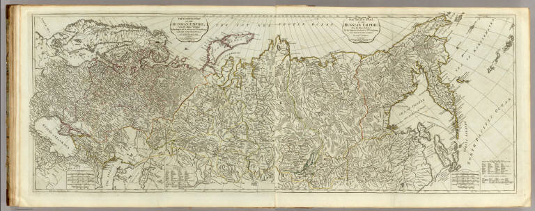
The European part of the Russian Empire from the maps published by the Imperial Academy at St. Petersburg, with the new provinces on the Black Sea. London, printed for Robert Sayer, Fleet Street, as the Act directs, 1st May, 1790. The Asiatic part of the Russian Empire from maps published by the Imperial Academy of St. Petersburg with the new discoveries of Captn. Cook &c. London, printed by Robert Sayer, Fleet Street, as the Act directs, 1st May 1788.
List No
0411.027
Note
Engraved map in outline color. 2 maps. Shows vegetation, sailing and explorers tracks, etc. Relief shown pictorially. Prime meridian: Ferro. David Rumsey Collection copy mounted as 1 sheet.
Author
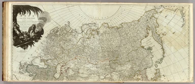
Kitchin, Thomas
Full Title
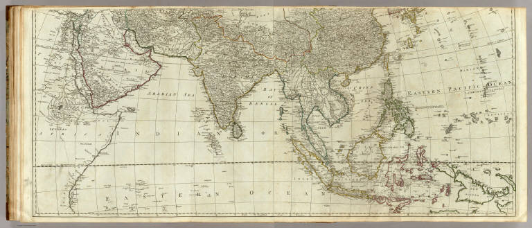
Asia and its islands according to d'Anville; divided into empires, kingdoms, states, regions, &ca. with the European possessions and settlements in the East Indies and an exact delineation of all the discoveries made in the eastern parts by the English under Captn. Cook. (Northern section. By Thomas Kitchin). London, printed for Robert Sayer, Fleet Street as the Act directs, 6 Jany. 1787.
List No
0411.028
Note
Engraved map in outline color. Printed on 2 sheets. Relief shown pictorially. Includes historical and geographical notes. Ornamental cartouche. David Rumsey Collection copy mounted as 1 sheet.
Author
Kitchin, Thomas
Full Title
(Asia and its islands according to d'Anville; divided into empires, kingdoms, states, regions, &ca. with the European possessions and settlements in the East Indies and an exact delineation of all the discoveries made in the eastern parts by the English under Captn. Cook. Southern section. By Thomas Kitchin. London, printed for Robert Sayer, Fleet Street as the Act directs, 6 Jany. 1787)
List No
0411.029
Note
Engraved map in outline color. Printed on 2 sheets. Relief shown pictorially. Includes historical and geographical notes. David Rumsey Collection copy mounted as 1 sheet.
Author
Kitchin, Thomas
Full Title
(Composite of) Asia and its islands according to d'Anville; divided into empires, kingdoms, states, regions, &ca. with the European possessions and settlements in the East Indies and an exact delineation of all the discoveries made in the eastern parts by the English under Captn. Cook. (By Thomas Kitchin). London, printed for Robert Sayer, Fleet Street as the Act directs, 6 Jany. 1787.
List No
0411.030
Note
Engraved map in outline color. Printed on 4 sheets. Relief shown pictorially. Includes historical and geographical notes. David Rumsey Collection copy mounted as 2 sheets. (E 20--W 165/N 80--S 13)
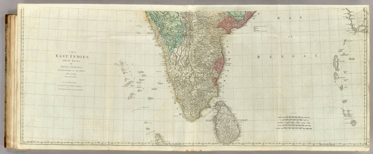
Author
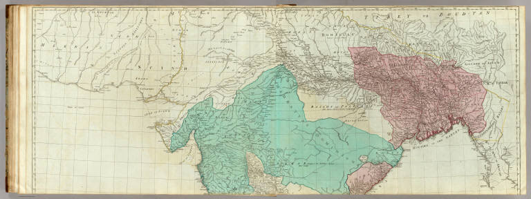
Jefferys, Thomas
Full Title
(The East Indies, with the roads. Northern section. By Thomas Jefferys, Geographer to the King. MDCCLXVIII. The second edition. London, published according to Act of Parliament, 30th Apr. 1768 by Robt. Sayer, no. 53 in Fleet Street)
List No
0411.031
Note
Engraved map in outline color. Printed on 2 sheets. Relief shown pictorially. Includes ethnographic and geographic notes. Prime meridians: London and Ferro. "To the directors of the Honble. East India Company, Thos. Jefferys humbly dedicates this map." David Rumsey Collection copy mounted as 1 sheet.
Author
Jefferys, Thomas
Full Title
The East Indies, with the roads. (Southern section). By Thomas Jefferys, Geographer to the King. MDCCLXVIII. The second edition. London, published according to Act of Parliament, 30th Apr. 1768 by Robt. Sayer, no. 53 in Fleet Street.
List No
0411.032
Note
Engraved map in outline color. Printed on 2 sheets. Relief shown pictorially. Includes ethnographic and geographic notes. Prime meridians: London and Ferro. "To the directors of the Honble. East India Company, Thos. Jefferys humbly dedicates this map." David Rumsey Collection copy mounted as 1 sheet.
Author
Jefferys, Thomas
Full Title
(Composite of) The East Indies, with the roads. By Thomas Jefferys, Geographer to the King. MDCCLXVIII. The second edition. London, published according to Act of Parliament, 30th Apr. 1768 by Robt. Sayer, no. 53 in Fleet Street.
List No
0411.033
Note
Engraved map in outline color. Printed on 4 sheets. Relief shown pictorially. Includes ethnographic and geographic notes. Prime meridians: London and Ferro. David Rumsey Collection copy mounted as 2 sheets. "To the directors of the Honble. East India Company, Thos. Jefferys humbly dedicates this map." (E 76--E 113/N 28--N 5)
Author
Larousse
Full Title
Asie.
List No
0418.213
Author
Las Cases, Emmanuel-Auguste-Dieudonne
Full Title
Asia, with the European settlements, and the conquests of Gengis Kan & Tamerlane. Published as the act directs, Novr. 1. 1800. J. Barfield, Printer, Soho. No. 19. (to accompany) Le Sage's genealogical, chronological, historical and geographical atlas.
List No
0419.024
Note
Hand colored map. Shows political boundaries major cities, towns, and rivers. Includes descriptive text on history, and European possessions in Asia. Relief shown pictorially.
Full Title
L'Asie divisee en ses principaux etats. Avec pivilege du Roi 1783. (A Paris, chez Delamarche, Geogr., ca. 1800)
List No
0421.017
Note
Engraved map. Outline hand coloring. Relief shown pictorially. Prime meridian: Ferro.
Author
Lattre, Jean
Full Title
Les Indes Orientales et leur archipel. A Paris, ches Lattre. Avec priv. (ca. 1800)
List No
0421.018
Note
Engraved map. Outline hand coloring. Relief shown pictorially. Prime meridian: Ferro.
|