|
Author
Keane, William Aloysius (1922 - 2011)
Full Title
Bil Keane's Arizona an Arizona's Highways Map
List No
15732.000
Author
United States. Post Office Department
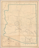
Full Title
Post Route Map of the State of Arizona 1913.
List No
15729.000
Author
[George F. Cram Company collection 1845-1955, National Highways Association]
Full Title
Arizona. The George F. Cram Company, Chicago. (to accompany) Auto trails and commercial survey of the United States.
List No
13688.013
Note
Map showing administrative boundaries, roads and electric lines in red.
Author
[George F. Cram Company collection 1845-1955, National Highways Association]
Full Title
Arizona. The George F. Cram Company, Chicago. (to accompany) Auto trails and commercial survey of the United States.
List No
13688.014
Note
Map showing main traveled highways in red lines.
Author
[3, Soviet Union. Glavnoe upravlenie geodezii i kartografii]
Full Title
Запад США = Zapad SShA. 242-243. Atlas Mira : 1954.
List No
13682.256
Note
Physical map of the West of the United States. Showing state boundaries. Relief shown by shadings, contours and spot heights. Depths shown by gradient tints, isolines and soundings.
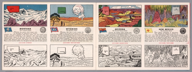
Author
[Fisher, Joseph R., Planters Peanuts (Firm)]
Full Title
Montana : The treasure state -- Wyoming : The equality state -- Arizona : The Grand Canyon state -- New Mexico : The sunshine state.
List No
14374.014
Note
Four views, representing Montana, Wyoming, Arizona and New Mexico. Views show examples of the landscape and natural resources. Each view includes an inset map of the state, which marks the location of the capital city with a star. Accompanied by descriptive text, the state flags, seals and flowers: bitterroot, Indian paint brush, saguaro cactus and yucca flower, respectively. The view of each state appears both in color (on top) and in black and white (bottom), the latter inviting coloration. Together, views are 18 x 52 cm, on two sheets 20 x 54 cm.
Author
[Aitchison, Robert T. (1887-1964), Jackson, Bill]
Full Title
Indian Ruins of the Southwest
List No
15197.000
Author
Silicon Maps Inc. - City Design
Full Title
Silicon Desert
List No
15115.000
Author
[National U. S. 66 Highway Association, Andrews, Willard]
Full Title
Follow U. S. 66 across Arizona through the southwest's scenic wonderland. Willard Andrews.
List No
14283.003
Note
Road map of Highway 66, from Yucca, Arizona to the Petrified Forest of Arizona. Includes a panoramic illustration featuring scenery along the way. With photographs in top and bottom margins, highlighting tourist sites, such as Meteor Crater. Unfolded to 23 x 41 cm.
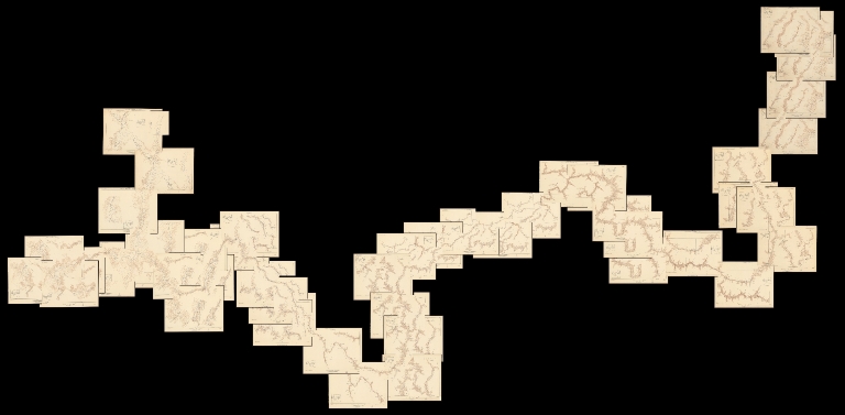
Author
[Birdseye, C.H., Burchard, R.W., U.S. Geological Survey]
Full Title
(Composite map of) Sheets A - N. Plan and Profile of Colorado River From Lees Ferry, Ariz., To Black Canyon, Ariz.-Nev., and Virgin River, Nev. 21 Sheets (14 plans, 7 profiles).
List No
10974.001
Author
[Birdseye, C.H., Burchard, R.W., U.S. Geological Survey]
Full Title
Sheet A. Plan and Profile of Colorado River From Lees Ferry, Ariz., To Black Canyon, Ariz.-Nev., and Virgin River, Nev. 21 Sheets (14 plans, 7 profiles).
List No
10974.002
Author
[Birdseye, C.H., Burchard, R.W., U.S. Geological Survey]
Full Title
Sheet B. Plan and Profile of Colorado River From Lees Ferry, Ariz., To Black Canyon, Ariz.-Nev., and Virgin River, Nev. 21 Sheets (14 plans, 7 profiles).
List No
10974.003
Author
[Birdseye, C.H., Burchard, R.W., U.S. Geological Survey]
Full Title
Sheet C. Plan and Profile of Colorado River From Lees Ferry, Ariz., To Black Canyon, Ariz.-Nev., and Virgin River, Nev. 21 Sheets (14 plans, 7 profiles).
List No
10974.004
Author
[Birdseye, C.H., Burchard, R.W., U.S. Geological Survey]
Full Title
Sheet D. Plan and Profile of Colorado River From Lees Ferry, Ariz., To Black Canyon, Ariz.-Nev., and Virgin River, Nev. 21 Sheets (14 plans, 7 profiles).
List No
10974.005
Author
[Birdseye, C.H., Burchard, R.W., U.S. Geological Survey]
Full Title
Sheet E. Plan and Profile of Colorado River From Lees Ferry, Ariz., To Black Canyon, Ariz.-Nev., and Virgin River, Nev. 21 Sheets (14 plans, 7 profiles).
List No
10974.006
Author
[Birdseye, C.H., Burchard, R.W., U.S. Geological Survey]
Full Title
Sheet F. Plan and Profile of Colorado River From Lees Ferry, Ariz., To Black Canyon, Ariz.-Nev., and Virgin River, Nev. 21 Sheets (14 plans, 7 profiles).
List No
10974.007
Author
[Birdseye, C.H., Burchard, R.W., U.S. Geological Survey]
Full Title
Sheet G. Plan and Profile of Colorado River From Lees Ferry, Ariz., To Black Canyon, Ariz.-Nev., and Virgin River, Nev. 21 Sheets (14 plans, 7 profiles).
List No
10974.008
Author
[Birdseye, C.H., Burchard, R.W., U.S. Geological Survey]
Full Title
Sheet H. Plan and Profile of Colorado River From Lees Ferry, Ariz., To Black Canyon, Ariz.-Nev., and Virgin River, Nev. 21 Sheets (14 plans, 7 profiles).
List No
10974.009
Author
[Birdseye, C.H., Burchard, R.W., U.S. Geological Survey]
Full Title
Sheet I. Plan and Profile of Colorado River From Lees Ferry, Ariz., To Black Canyon, Ariz.-Nev., and Virgin River, Nev. 21 Sheets (14 plans, 7 profiles).
List No
10974.010
Author
[Birdseye, C.H., Burchard, R.W., U.S. Geological Survey]
Full Title
Sheet J. Plan and Profile of Colorado River From Lees Ferry, Ariz., To Black Canyon, Ariz.-Nev., and Virgin River, Nev. 21 Sheets (14 plans, 7 profiles).
List No
10974.011
Author
[Birdseye, C.H., Burchard, R.W., U.S. Geological Survey]
Full Title
Sheet K. Plan and Profile of Colorado River From Lees Ferry, Ariz., To Black Canyon, Ariz.-Nev., and Virgin River, Nev. 21 Sheets (14 plans, 7 profiles).
List No
10974.012
Author
[Birdseye, C.H., Burchard, R.W., U.S. Geological Survey]
Full Title
Sheet L Plan and Profile of Colorado River From Lees Ferry, Ariz., To Black Canyon, Ariz.-Nev., and Virgin River, Nev. 21 Sheets (14 plans, 7 profiles).
List No
10974.013
Author
[Birdseye, C.H., Burchard, R.W., U.S. Geological Survey]
Full Title
Sheet M. Plan and Profile of Colorado River From Lees Ferry, Ariz., To Black Canyon, Ariz.-Nev., and Virgin River, Nev. 21 Sheets (14 plans, 7 profiles).
List No
10974.014
Author
[Birdseye, C.H., Burchard, R.W., U.S. Geological Survey]
Full Title
Sheet N. Plan and Profile of Colorado River From Lees Ferry, Ariz., To Black Canyon, Ariz.-Nev., and Virgin River, Nev. 21 Sheets (14 plans, 7 profiles).
List No
10974.015
Author
Rand McNalley & Company
Full Title
Rand McNally road map : Arizona -- New Mexico.
List No
14003.012
Note
Road map of Arizona and New Mexico, showing interstate and state highways, paved and dirt roads, as well as drainage and ports, and state and national parks. Includes compass rose, time zones, and bar scale with scale statement: One inch equals approximately 31 miles. Features legend indicating population. Copyright by Rand McNally & Company, Chicago, Ill. Lithographed in the U.S.A.
Author
Waldmire, Robert, 1945-2009
Full Title
Yuma, in historic southwestern Arizona. Robert Waldmire, Robert Waldmire, The artist, 1982. Dark age Graphics, R.R. 2. Rochester, Illinois 62563.
List No
13629.000
Author
Waldmire, Robert, 1945-2009
Full Title
Tempe and the rest of the urban sprawl. And Arizona State University. Another Slice o' life poster by Android, # 345-36-5919.
List No
13636.000
Author
Waldmire, Robert, 1945-2009
Full Title
Tucson. The University of Arizona.
List No
13637.000
Author
Roskruge, George J.
Full Title
Official Map of Pima County Arizona Authorized by Board of Supervisors Compiled & Drawn by George J. Roskruge ex-County Surveyor
List No
10719.000
Author
H.M. Gousha Company
Full Title
1937 road map of Arizona. Prepared exclusively for Standard Oil Company of California. Copyright by the H.M. Gousha Company, Chicago, Ill. Printed in U.S.A. 285-S.C. (to accompany) Standard Oil road map. C.J. Moody.
List No
9875.002
Note
Color map, double page. Shows roads, highways, trails, state parks, monuments, national forests, airports, drainage, distances, places of interest, etc. Includes legend and index to cities and towns. Includes RPM Motor Oil logo. Relief shown by hachures and spot heights.
Author
Rheault, Jean-Louis
Full Title
Navajo Nation.
List No
10463.000
Author
Mora, Jo (1876-1947)
Full Title
Grand Canyon. (Drawn by) Jo Mora. Copyright 1931. The Jo Mora Maps, Carmel California.
List No
10410.001
Note
This is the original drawing made by Jo Mora for the Grand Canyon map. It is about 25% larger than the printed version. See our printed copy at 8077.000. Uncolored pictorial map of Grand Canyon. Shows many humorous scenes and the activities common at the time in Grand Canyon and vicinity. Many landmarks are shown in an amusing way with historical notes. Includes illustrations in the border of Scenes and activities, with Scenic Airways, Inc. airplane on the upper center of the map. Artist Joseph "Jo" Jacinto Mora was born in Uruguay in 1876 and became an illustrator after moving to the Untied States in the early 1900s. For more information on Jo Mora's life and works, see http://www.jomoratrust.com
Author
[United States Bureau of Topographical Engineers, Dougal, W.H.]
Full Title
Old Territory and Military Department of New Mexico : compiled in the Bureau of Topogl. Engrs. of the War Dept. chiefly for military purposes. Under the authority of the Secretary of War 1850. Partially revised and corrected to 1867. Engraved by W. H. Dougal.
List No
11231.000
Note
Uncolored map, published prior to and revised after the Civil War. List of Authorities identifies 19 maps created by explorers of the region published between 1843 and 1858. Shows boundaries, principal travel routes, trails, mail routes, cities and villages, rivers and creeks. Includes list of Principal latitudes & longitudes astronomically determined. Includes notes.
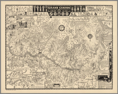
Author
Mora, Jo (1876-1947)
Full Title
Grand Canyon. (Drawn by) Jo Mora. Copyright 1931. The Jo Mora Maps, Carmel California.
List No
8077.000
Note
Uncolored pictorial map of Grand Canyon. Shows many humorous scenes and the activities common at the time in Grand Canyon and vicinity. Many landmarks are shown in an amusing way with historical notes. Includes illustrations in the border of Scenes and activities, with Scenic Airways, Inc. airplane on the upper center of the map. Artist Joseph "Jo" Jacinto Mora was born in Uruguay in 1876 and became an illustrator after moving to the Untied States in the early 1900s. For more information on Jo Mora's life and works, see http://www.jomoratrust.com
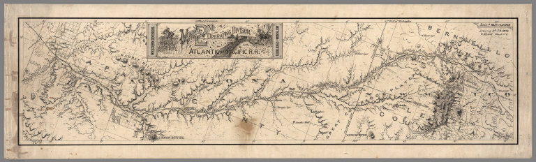
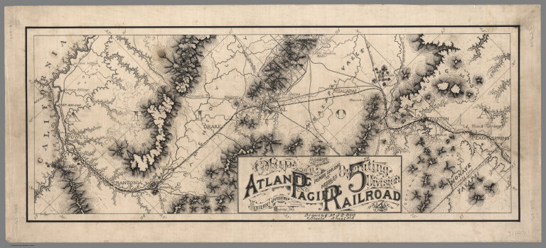
Author
Atlantic & Pacific Railroad
Full Title
Map of the 2nd Operating Division of the Western Division, Atlantic & Pacific R.R., From Coolidge to Winslow. Drawing No. J-2-902.
List No
6929.002
Note
Lavishly illustrated title block. No drawing on verso. A set of six hand-drawn maps on semi-transparent waxed linen with some color. Some areas are colored on the verso to highlight the areas in a muted style. We think that some type of backlighting was planned to be used to create a photolithographic plate from which printing would be done. No evidence was found that it was ever printed. These sheets were deaccessioned from the Santa Fe Railroad collection in the 1980s. Lewis Kingman did the route survey from Albuquerque to Needles. Relief shown by hachures.
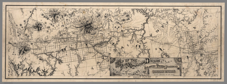
Author
Atlantic & Pacific Railroad
Full Title
Map of the Third Operating Division of the Western Division, Atlantic & Pacific R.R., From From Winslow to Williams. Drawing No. J-2-902.
List No
6929.003
Note
Drawing on verso behind title block. A set of six hand-drawn maps on semi-transparent waxed linen with some color. Some areas are colored on the verso to highlight the areas in a muted style. We think that some type of backlighting was planned to be used to create a photolithographic plate from which printing would be done. No evidence was found that it was ever printed. These sheets were deaccessioned from the Santa Fe Railroad collection in the 1980s. Lewis Kingman did the route survey from Albuquerque to Needles. Relief shown by hachures.
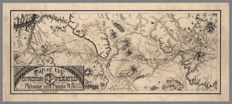
Author
Atlantic & Pacific Railroad
Full Title
Map of the 4th Operating Division of the Western Division, Atlantic & Pacific R.R., From Williams to Peach Springs. Drawing No. J-2-902.
List No
6929.004
Note
Drawing on verso behind title block. A set of six hand-drawn maps on semi-transparent waxed linen with some color. Some areas are colored on the verso to highlight the areas in a muted style. We think that some type of backlighting was planned to be used to create a photolithographic plate from which printing would be done. No evidence was found that it was ever printed. These sheets were deaccessioned from the Santa Fe Railroad collection in the 1980s. Lewis Kingman did the route survey from Albuquerque to Needles. Relief shown by hachures.
Author
Atlantic & Pacific Railroad
Full Title
Map of the 5th Operating Division of the Western Division, Atlantic & Pacific R.R., From Peach Springs to Needles. W.A. Drake, Acting Chief Engineer. Drawing No. J-2-902.
List No
6929.005
Note
No drawing on verso. A set of six hand-drawn maps on semi-transparent waxed linen with some color. Some areas are colored on the verso to highlight the areas in a muted style. We think that some type of backlighting was planned to be used to create a photolithographic plate from which printing would be done. No evidence was found that it was ever printed. These sheets were deaccessioned from the Santa Fe Railroad collection in the 1980s. Lewis Kingman did the route survey from Albuquerque to Needles. Relief shown by hachures.
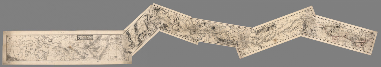
Author
Atlantic & Pacific Railroad
Full Title
(Composite of) Maps of the First through Sixth Operating Divisions of the Western Division, Atlantic & Pacific Railroad, Albuquerque, New Mexico, to Mojave (Mohave), California.
List No
6929.007
Note
Composite of all six maps joined together end to end. This is a set of six hand-drawn maps on semi-transparent waxed linen with some color. Some areas are colored on the verso to highlight the areas in a muted style. We think that some type of backlighting was planned to be used to create a photolithographic plate from which printing would be done. No evidence was found that it was ever printed. These sheets were deaccessioned from the Santa Fe Railroad collection in the 1980s. Lewis Kingman did the route survey from Albuquerque to Needles. Relief shown by hachures.
Author
Bancroft, A.L.
Full Title
Bancroft's Map Of California, Nevada, Utah And Arizona. Published By A.L. Bancroft & Compy. Booksellers & Stationers, San Francisco, Cal. 1873. Entered ... by A.L. Bancroft & Company ... Washington, D.C.
List No
0046.000
Note
1st edition was 1864. From Bancroft's Map the of Pacific States which appeared in 1863. Wheat says Bancroft changed the large Pacific States map in 1870, but we believe that the smaller maps such as this continue to be from the original 1863 or 1867 plates, updated to show railroad expansion and topographical changes. With black top and bottom rollers. Full color by county.
Author
Appleton, D. & Co.
Full Title
Map of New Mexico and Arizona. Copyright 1891 by Matthews-Northrup Co. ... Buffalo, New York. (to accompany) The Library Atlas Of Modern Geography ... New York, D. Appleton And Company 1892. (on upper margin) New Mexico and Arizona. 85.
List No
0026.219
Note
Color map. Shows county boundaries and county seat, capital, railways, roads, rivers, etc. "Size of type indicates importance of the places". Includes notes. Prime meridians are Greenwich and Washington. Relief shown by hachures.
Author
Arbuckle Bros.
Full Title
Territory of Arizona, Nebraska, Nevada, Arkansas. Copyright 1889 Arbuckle Bros. N.Y.
List No
0027.012
Note
Sheet with maps of four states in full color. The notes about Arizona describe the Grand Canyon ("a deep channel through the rocks, so that for long distances it flows between perpendicular walls 7,000 feet in height") but does not call it such. Nevada is known as the "great silver State of the Union." Each card measures 7.5 x 12.5 cm.
Author
Asher & Adams
Full Title
Asher & Adams' Arizona. Entered according to Act of Congress in the year 1874 by Asher & Adams ... at Washington. (New York, 1874)
List No
0041.041
Note
Hand col. engraved map. Relief shown by hachures. Shows townships, etc. Prime meridians: Greenwich and Washington.
Author
[Bancroft, A.L., Knight, W.H.]
Full Title
(Covers to) Bancroft's Map Of California, Nevada, Utah And Arizona. Published By A.L. Bancroft, & Compy. Booksellers & Stationers San Francisco Cal. 1876. Entered ... by A.L. Bancroft & Company ... Washington, D.C.
List No
0047.001
Note
Additional railroads when compared to the 1873 edition. Full color by county. Folded into dark brown cloth covers 16x11 with title "Bancroft's Map Of California, Nevada, Utah & Arizona." in gold. Relief shown by hachures.
Author
[Bancroft, A.L., Knight, W.H.]
Full Title
Bancroft's Map Of California, Nevada, Utah And Arizona. Published By A.L. Bancroft, & Compy. Booksellers & Stationers San Francisco Cal. 1876. Entered ... by A.L. Bancroft & Company ... Washington, D.C.
List No
0047.002
Note
Additional railroads when compared to the 1873 edition. Full color by county. Folded into dark brown cloth covers 16x11 with title "Bancroft's Map Of California, Nevada, Utah & Arizona." in gold. Relief shown by hachures.
Author
Colton, G.W.
Full Title
Colton's Map of California, Nevada, Utah, Colorado, Arizona & New Mexico. Published By J. H. Colton. No. 172 William St. New York.
List No
0151.062
Note
Shows routes, dates of exploration and the explorers. Prime meridians are Greenwich and Washington D.C. Relief shown by hachures
Author
Colton, G.W.
Full Title
Colton's Map of California, Nevada, Utah, Colorado, Arizona and New Mexico. Published By G. W & C. B. Colton & Co. No. 172 William St. New York.
List No
0152.064
Note
Prime meridians are Washington D.C. and Greenwich.
Author
Cram, George Franklin
Full Title
Arizona.
List No
0210.052
Note
Prime meridians Greenwich and Washington.
Author
Gray, O.W.
Full Title
Gray's Atlas Map of New Mexico and Arizona.
List No
0310.077
Author
[Gray, Frank A., Gray, O.W.]
Full Title
Arizona and New Mexico.
List No
0312.055
Author
Ives, J.C.
Full Title
Explorations and Surveys. War Department. Map No. 2. Rio Colorado of the West, explored by 1st Lieut. Joseph C. Ives, Topl. Engrs. under the direction of the Office of Explorations and Surveys. A.A. Humphreys, Capt. Topl. Engrs. in Charge, by order of the Hon. John B. Floyd, Secretary of War. 1858. Drawn by Frhr. F.W.v. Egloffstein. Topographer to the Expedition. Topography by Frhr. F.W.v. Egloffstein. Ruling by Samuel Sartain. Lettering by F. Courtenay.
List No
0341.002
Note
Uncolored map showing the Grand Canyon in superb detail. The "line of exploration" and camps are shown.
Author
Ives, J.C.
Full Title
(Table of Contents to) Report Upon The Colorado River of the West, Explored in 1857 and 1858 By Lieutenant Joseph C. Ives, Corps Of Topographical Engineers, Under The Direction Of The Office Of Explorations And Surveys, A.A. Humphreys, Captain Topographical Engineers, In Charge. By Order Of The Secretary Of War. Washington: Government Printing Office. 1861. Senate. 36th Congress, 1st Session. Ex. Doc.
List No
0341.009
Note
General Table of Contents to the five parts and four appendicies.
Author
Ives, J.C.
Full Title
List of Illustrations (Part I).
List No
0341.010
Author
Ives, J.C.
Full Title
List of Illustrations (continued) (Part I).
List No
0341.011
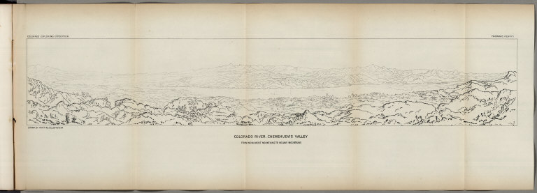
Author
Ives, J.C.
Full Title
Colorado River. Chemehuevis Valley, From Monument Mountains to Mojave Mountains. Colorado Exploring Expedition. Panoramic View No. 1. Drawn by Frhr. F.W. v. Ecloffstein.
List No
0341.015
Author
Ives, J.C.
Full Title
Fig 1. - Yuma Shoals.
List No
0341.016
Author
Ives, J.C.
Full Title
Fig 2. - Explorer's Pass.
List No
0341.017
Author
Ives, J.C.
Full Title
Fig 3. - Purple Hills.
List No
0341.018
Author
Ives, J.C.
Full Title
Cane Brake Canyon, from near Camp 16. Colorado Exploring Expedition. General Report - Plate II. J.J. Young from a sketch by F.W. Egloffstein. Lith Sarony, Major & Knapp, 449 Broadway N.Y.
List No
0341.019
Author
Ives, J.C.
Full Title
Fig 4. - Purple Hills Pass.
List No
0341.020
Author
Ives, J.C.
Full Title
Fig 5. - Red Rock Gate.
List No
0341.021
Author
Ives, J.C.
Full Title
Fig 6. - Sleeper's Bend.
List No
0341.022
Author
Ives, J.C.
Full Title
Fig 7. - Light-house Rock.
List No
0341.023
Author
Ives, J.C.
Full Title
Fig 8. - Riverside Mountains.
List No
0341.024
Author
Ives, J.C.
Full Title
Chemehuevis. Colorado Exploring Expedition. Indian Portraits, Plate III. B. Mollhausen, Del. Lith. of Sarony, Major & Knapp, 449 Broadway N.Y.
List No
0341.025
Note
Color.
Author
Ives, J.C.
Full Title
Fig 9. - Monument Mountains.
List No
0341.026
Author
Ives, J.C.
Full Title
Fig 10. - Corner Rock.
List No
0341.027
Author
Ives, J.C.
Full Title
Fig 11. - Monument Canyon.
List No
0341.028
Author
Ives, J.C.
Full Title
Fig 12. - Monument Range from the North.
List No
0341.029
Author
Ives, J.C.
Full Title
Fig 13. - Mount Whipple.
List No
0341.030
Author
Ives, J.C.
Full Title
Fig 14. - Remains of Grand Mesa in Chemehuevis Valley.
List No
0341.031
Author
Ives, J.C.
Full Title
Mojave Canon. Colorado Exploring Expedition. General Report, Plate III. J.J. Young from a sketch by H.B. Mollhausen, Del.
List No
0341.032
Author
Ives, J.C.
Full Title
Fig 15. - Mouth of Mojave Canon.
List No
0341.033
Note
Page has a large block of foxing.
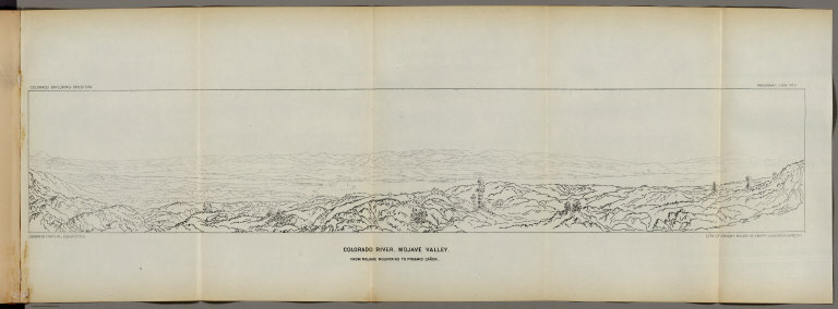
Author
Ives, J.C.
Full Title
Colorado River. Mojave Valley, From Mojave Mountains to Pyramid Canon. Colorado Exploring Expedition. Panoramic View No. 2. Drawn by Frhr. F.W. v. Ecloffstein. Lith. of Sarony Major & Knapp, 449 Broadway N.Y.
List No
0341.034
Author
Ives, J.C.
Full Title
Fig 16. - Head of Mojave Canon.
List No
0341.035
Author
Ives, J.C.
Full Title
Mojaves. Ireteba. Cairook. Colorado Exploring Expedition. Indian Portraits, Plate IV. B. Mollhausen, Del. Lith. of Sarony, Major & Knapp, 449 Broadway N.Y.
List No
0341.036
Note
Color.
Author
Ives, J.C.
Full Title
Fig 17. - Boundary Cone.
List No
0341.037
Author
Ives, J.C.
Full Title
Fig 18. - Beale's Pass.
List No
0341.038
Author
Ives, J.C.
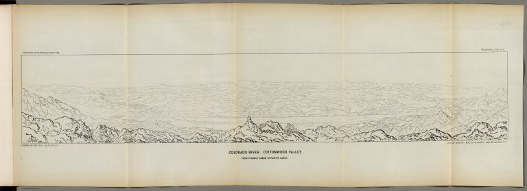
Full Title
Colorado River. Cottonwood Valley, From Pyramid Canyon to Painted Canyon. Colorado Exploring Expedition. Panoramic View No. 3. Drawn by Frhr. F.W. v. Ecloffstein. Lith. of Sarony, Major & Knapp, 449 Broadway, N.Y.
List No
0341.040
Author
Ives, J.C.
Full Title
Fig 19. Pyramid Canyon.
List No
0341.041
Author
Ives, J.C.
Full Title
Fig 20. Deep Rapid.
List No
0341.042
Author
Ives, J.C.
Full Title
Fig 21. Cottonwood Valley.
List No
0341.043
Author
Ives, J.C.
Full Title
Fig 22. Painted Canyon.
List No
0341.044
Note
Large block of foxing.
Author
Ives, J.C.
Full Title
Black Canyon. Colorado Exploring Expedition. General Report, Plate V. F.W. Egloffstein from a sketch by Lieut. Ives.
List No
0341.045
Author
Ives, J.C.
Full Title
Fig 23. Mount Davis.
List No
0341.046
Author
Ives, J.C.
Full Title
Fig 24. Gravel Bluffs south of Black Mountains.
List No
0341.047
Author
Ives, J.C.
Full Title
Fig 25. Mouth of Black Canyon.
List No
0341.048
Author
Ives, J.C.
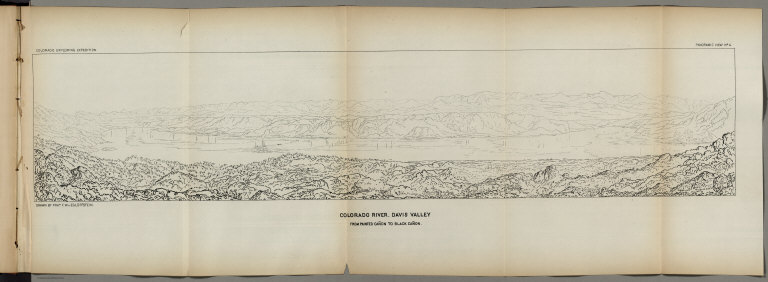
Full Title
Colorado River. Davis Valley, From Painted Canyon to Black Canyon. Colorado Exploring Expedition. Panoramic View No. 4. Drawn by Frhr. F.W. v. Ecloffstein.
List No
0341.049
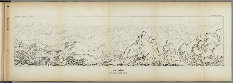
Author
Ives, J.C.
Full Title
Colorado River. Big Canyon, from near Hualpais Spring. Colorado Exploring Expedition. Panoramic View No. 5. Drawn by Frhr. F.W. v. Ecloffstein.
List No
0341.050
Author
Ives, J.C.
Full Title
Fig 26. Meadow Creek.
List No
0341.051
Author
Ives, J.C.
Full Title
Fig 27. Iretaba's Mountain.
List No
0341.052
Author
Ives, J.C.
Full Title
Hualpais. Colorado Exploring Expedition. Indian Portraits, Plate V. B. Mollhausen, Del. Lith. of Sarony, Major & Knapp, 449 Broadway N.Y.
List No
0341.053
Note
Color.
Author
Ives, J.C.
Full Title
Fig 28. Railroad Pass.
List No
0341.054
Author
Ives, J.C.
Full Title
Fig 29. Cerbat Basin.
List No
0341.055
Author
Ives, J.C.
Full Title
Fig 30. Colorado Plateaus from near Peacock's Springs.
List No
0341.056
Author
Ives, J.C.
Full Title
Fig 31. Side Canyons of Diamond River.
List No
0341.057
Author
Ives, J.C.
Full Title
Big Canyon at Mouth of Diamond River. Colorado Exploring Expedition. General Report, Plate VI. J.J. Young from a sketch by F.W. Egloffstein.
List No
0341.058
Author
Ives, J.C.
Full Title
Fig 32. Side Canyons of the Colorado.
List No
0341.059
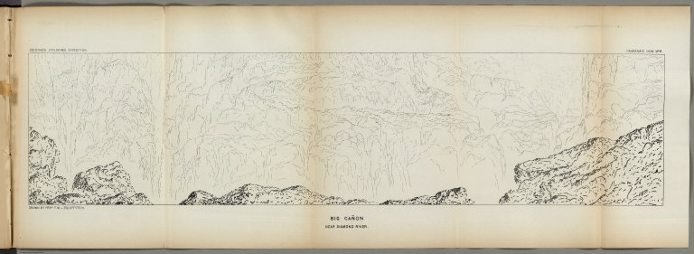
Author
Ives, J.C.
Full Title
Big Canyon near Diamond River. Colorado Exploring Expedition. Panoramic View No. 6. Drawn by Frhr. F.W. v. Ecloffstein.
List No
0341.060
Author
Ives, J.C.
Full Title
Fig 33. San Francisco Mountain from Colorado Plateau.
List No
0341.061
Author
Ives, J.C.
Full Title
Fig 34. Precipice Leading to Cataract Canyon.
List No
0341.062
Author
Ives, J.C.
Full Title
Camp - Colorado Plateau. Colorado Exploring Expedition. General Report, Plate VII. J.J. Young from a sketch by H.B. Mollhausen. Lith. of Sarony, Major & Knapp, 449 Boradway N.Y.
List No
0341.063
Author
Ives, J.C.
Full Title
Upper Cataract Creek near Big Canyon. Colorado Exploring Expedition. General Report, Plate VIII. J.J. Young from a sketch by F.W. Egloffstein.
List No
0341.064
Author
Ives, J.C.
Full Title
Fig 35. Side Canyons of Flax River.
List No
0341.065
Author
Ives, J.C.
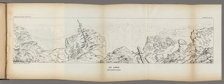
Full Title
Big Canyon. Colorado Exploring Expedition. General Report, Plate IX. J.J. Young from a sketch by F.W. Egloffstein.
List No
0341.066
Author
Ives, J.C.
Full Title
Fig 36. - Mount Floyd.
List No
0341.067
Author
Ives, J.C.
Full Title
Big Canyon from Colorado Plateau. Colorado Exploring Expedition. Panoramic View No. 7. Drawn by Frhr. F.W. v. Ecloffstein.
List No
0341.068
Note
Mounted upside down.
Author
Ives, J.C.
Full Title
Fig 37. Bill William's Mountain.
List No
0341.069
Author
Ives, J.C.
Full Title
Fig 38. Blue Peaks.
List No
0341.070
Author
Ives, J.C.
Full Title
Moquis Pueblos. Colorado Exploring Expedition. General Report, Plate X. J.J. Young from a sketch by F.W. Egloffstein.
List No
0341.071
Author
Ives, J.C.
Full Title
Moquis. Colorado Exploring Expedition. Indian Portraits, Plate VI. B. Mollhausen, Del. Lith. of Sarony, Major & Knapp, 449 Broadway N.Y.
List No
0341.072
Note
Color.
Author
Ives, J.C.
Full Title
Interior of a Moquis House. Colorado Exploring Expedition. General Report, Plate XI. J.J. Young from a sketch by F.W. Egloffstein.
List No
0341.073
Note
Color.
Author
Ives, J.C.
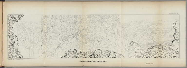
Full Title
Canyon of Cataract Creek and Flax River. Colorado Exploring Expedition. Panoramic View No. 8. Drawn by Frhr. F.W. v. Ecloffstein.
List No
0341.074
Note
Mounted upside down.
Author
Ives, J.C.
Full Title
Fig 39. View north from Oraybe Gardens.
List No
0341.075
Author
Ives, J.C.
Full Title
Navajos. Colorado Exploring Expedition. Indian Portraits, Plate VII. B. Mollhausen, Del. Lith. of Sarony, Major & Knapp, 449 Broadway N.Y.
List No
0341.076
Note
Color.
Author
Ives, J.C.
Full Title
Fig 40. Navajo valley.
List No
0341.077
Author
Ives, J.C.
Full Title
Fig 41. Valley of Fort Defiance.
List No
0341.078
Author
Ives, J.C.
Full Title
List of Illustrations (Part III).
List No
0341.079
Author
Ives, J.C.
Full Title
Shore of Lower Colorado. Colorado Exploring Expedition. Geology, Plate I. J.J. Young from a sketch by H.B. Mollhausen. Lith. of Sarony, Major & Knapp, 449 Broadway N.Y.
List No
0341.080
Author
Ives, J.C.
Full Title
Fig 3. Sections of Alluvial Bank of the Colorado. Fig 4. Cross Stratification formed by Changing Channel.
List No
0341.083
Author
Ives, J.C.
Full Title
Fig 5. Edge of Sun-cracked Stratum of Clay is Alluvial Bank of Colorado.
List No
0341.084
Author
Ives, J.C.
Full Title
Fig 6. View of Northern Entrance to Monument Canyon.
List No
0341.085
Author
Ives, J.C.
Full Title
The Needles (Mojave Range). Colorado Exploring Expedition. Geology, Plate II. J.J. Young from a sketch by H.B. Mollhausen. Lith. of Sarcony, Major & Knapp, 449 Broadway N.Y.
List No
0341.086
Author
Ives, J.C.
Full Title
Fig 7. Hills of Tertiary Conglomerate and Modern Gravel, Camp 49.
List No
0341.087
Author
Ives, J.C.
Full Title
Fig 8. Castle-like Conglomerate Bluff.
List No
0341.088
Note
Penciled notes: "9/5/32 Mellenbaugh(?) thinks this is "Fortification Rocks: at the mouth of the Virgin River - Joseph Page 188 of his narrative - calls it "The Temple" See page 87 of Ive's narrative.
Author
Ives, J.C.
Full Title
Fig 9. Cliffs of Tertiary Conglomerate -- Camp 54.
List No
0341.089
Author
Ives, J.C.
Full Title
Fig 10. Section of Trough of Colorado at Elephant Hill.
List No
0341.090
Author
Ives, J.C.
Full Title
Fig 11. Elephant Hill from Camp 55.
List No
0341.091
Author
Ives, J.C.
Full Title
Fig 12. Section of the Canyon of the Colorado on High Mesa West of the Little Colorado.
List No
0341.092
Author
Ives, J.C.
Full Title
Fig 13. Canada of Erosion through Western Range of the Cerbat Mountains.
List No
0341.093
Author
Ives, J.C.
Full Title
Near Head of Diamond Creek. Colorado River Expedition. General Report - Plate I. J.J. Young from a sketch by H.B. Mollhausen. Lith. of Sarony, Major & Knapp, 449 Broadway N.Y.
List No
0341.094
Author
Ives, J.C.
Full Title
Granite Pinnacles, Canyon of Diamond River.
List No
0341.095
Author
Ives, J.C.
Full Title
Fig 14. Section of Mesa Wall at Camp 70.
List No
0341.096
Author
Ives, J.C.
Full Title
Fig 15. Trap Mesas North of San Francisco Mountain.
List No
0341.097
Author
Ives, J.C.
Full Title
Fig 16. Section of Strata from the Picacho to Bill Williams's Mountain.
List No
0341.098
Author
Ives, J.C.
Full Title
Fig 17. Volcanic Cones East of the San Francisco Mountain.
List No
0341.099
Author
Ives, J.C.
Full Title
Fig 18. Mesa Walls of Red Sandstone.- Painted Desert.
List No
0341.100
Author
Ives, J.C.
Full Title
Fig 19. Section of Mesa between the Little Colorado and Moqui Villages.
List No
0341.101
Author
Ives, J.C.
Full Title
Fig 20. Eroded Sandstone, near the Moqui Villages (Camp 92).
List No
0341.102
Author
Ives, J.C.
Full Title
Fig 21. An Outlier of the Cretaceous Mesa, Moqui Villages.
List No
0341.103
Author
Ives, J.C.
Full Title
Fig 22. Distant View of Great White Mesa, from near Camp 96.
List No
0341.104
Author
Ives, J.C.
Full Title
Fig 23. Monument in Eroded Valley, near Camp 100.
List No
0341.105
Author
Ives, J.C.
Full Title
Fig 24. Natural Bridge, Camp 100.
List No
0341.106
Author
Ives, J.C.
Full Title
Fig 25. Masses of White Calcareous Sandstone Shaped by Erosion, near Camp 100.
List No
0341.107
Author
Ives, J.C.
Full Title
Fig 26. Section of the Valley at Fort Defiance.
List No
0341.108
Author
Ives, J.C.
Full Title
Fig 27. Section of Dislocated Strata at Salt Spring.
List No
0341.109
Author
Ives, J.C.
Full Title
Geological Map No. 2. Prepared by J.S. Newberry, M.D. Geologist to the Expedition. Explorations and Surveys. War Department. Map No. 1. Rio Colorado of the West, explored by 1st Lieut. Joseph C. Ives, Topl. Engrs. under the direction of the Office of Explorations and Surveys. A.A. Humphreys, Capt. Topl. Engrs. in Charge, by order of the Hon. John B. Floyd, Secretary of War. 1858. Drawn by Frhr. F.W.v. Egloffstein. Topographer to the Expedition. Topography by Frhr. F.W.v. Egloffstein. Ruling by Samuel Sartain. Lettering by F. Courtenay.
List No
0341.004
Note
Color washed map showing the Grand Canyon in superb detail with geological information included. A key is added below the map. The "line of exploration" and camps are shown.
Author
Johnson, A.J.
Full Title
Johnson's California also Utah, Nevada, Colorado, New Mexico, and Arizona. Entered ... 1864.
List No
0358.049
Author
Leahy, J.F.
Full Title
(Index Page to) Leahy's Hotel Guide and Railway Distance Maps. Arizona.
List No
0425.008
Note
Alphabetical index list of the Hotels of the town with the number of rooms of each, their rates per day and the population of the town. Includes population of the state, explanation of abbreviation of the railroad of the State, text and advertisement.
Author
Leahy, J.F.
Full Title
Leahy's Hotel Guide and Railway Distance Map of the State of Arizona. Published by American Hotel Register Company. Leahy Build., 228-234 W. Ontario St., Chicago, Ill. Copyrighted by J.F. Leahy, Jan., 1934.
List No
0425.009
Note
Map printed without color. Includes name of the railroad entering the town, and distance between towns.
Author
Johnson, A.J.
Full Title
Johnson's California, With Utah, Nevada, Colorado, New Mexico And Arizona Published By Johnson and Ward.
List No
0535.041
Note
In full color. Various routes shown: Proposed Central Pacific Railroad, Proposed Union Pacific Railroad, Pacific Railroad, Pony Express, Emigrant Road, Simpson 1859, Fremont 1845, Fremont 1844, Fremont 1843, Spanish Trail from Los Angeles to Albiguia New Mexico, Spainish Trail from Salt Lake to Santa Fe, Captain Gunnison 1855, Captain Sitgreaves 1951, Major Emory 1846, El Paso Waggon (Wagon) Road, Cimarron Route to Fort Leavenworth, Colonel Washington, etc. Delineates various Indian lands. Shows Head of Navigation on the Colorado River at the confluence with the Virgin River. Relief shown by hachures. Meridians Greenwich and Washington D.C.
Author
Mitchell, Samuel Augustus Jr.
Full Title
Arizona and New Mexico. Entered ... 1867 by S. Augustus Mitchell, Jr. ... Pennsylvania.
List No
0579.044
Note
Color map by state and county. Relief shown by hachures. Prime meridians are Greenwich and Washington, D.C.
Author
Mitchell, Samuel Augustus
Full Title
County map of Arizona and New Mexico. Entered ... 1879 by S. Augustus Mitchell ... Washington. (1880)
List No
0586.047
Note
Hand colored. Relief shown by hachures. Shows Indian tribes, settlements, rivers, etc. Prime meridians: Greenwich and Washington. On verso: County map of Utah and Nevada (p. 91)
Author
Mitchell, Samuel Augustus Jr.
Full Title
County and township map of Arizona and New Mexico. Entered ... 1882 by S. Augustus Mitchell....
List No
0592.049
Note
Hand colored. Relief shown by hachures. Shows Indian reservations, military reservations, inhabited places, railroads, drainage, etc. Prime meridians: Greenwich and Washington.
Full Title
County and township map of Arizona and New Mexico. Copyright 1887 by Wm. M. Bradley & Bro. (1890)
List No
0594.047
Note
Hand colored. Relief shown by hachures. Shows Indian reservations, military reservations, inhabited places, railroads, drainage, etc. Prime meridians: Greenwich and Washington.
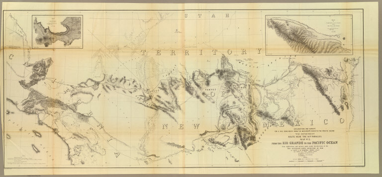
Author
[Ives, J.C., Whipple, A.W.]
Full Title
From the Rio Grande to the Pacific Ocean from explorations and surveys made under the direction of the Hon. Jefferson Davis, Secretary of War by Lieut. A.W. Whipple, Topogl. Engrs. and Lieut. J.C. Ives, Topogl. Engrs. A.H. Campbell, Civil Eng. and Surveyor, Asst. Surveyors: Wm. White Jr., N.H. Hutton, and J.P. Sherburne. 1853-4. Explorations and Surveys for a Rail Road Route from the Mississippi River to the Pacific Ocean, War Department, Route Near the 35th Parallel, Map No. 2. Engr. by Selmar Siebert. Drawn by John D. Hoffmann.
List No
0693.038
Note
The uncolored map stretches from Albuquerque in the east across the southwest to Los Angeles. With two inset maps: "Sketch of Campbell's Pass from Agua Azul to Salt Spring" and "Sketch of Aztec Pass."
Author
Pike, Zebulon Montgomery
Full Title
A Map of The Internal Provinces of New Spain. The Outlines are from the Sketches of but corrected and improved by Captain Zebulon M. Pike, who was conducted through that Country, in the Year 1807, by Order of the Commandant General of those Provinces.
List No
0730.004
Note
A large uncolored map stretching from the Baja peninsula to Nacogdoches in the east. Provincial boundaries, capitals of provinces or kingdoms, Indian and Spanish villages, and the American Troops route all shown in detail.
Author
Randolph Co.
Full Title
San Francisco Peak. Randolph Co., N.Y. (1895)
List No
0740.002
Note
Uncolored view.
Author
Nichols, H. H.
Full Title
The Mogollon Escarpment. H.H. Nichols. (1895)
List No
0740.004
Note
Uncolored view.
Author
Nichols, H. H.
Full Title
The site of Moenkopi. H.H. N(ichols) '90. (1895)
List No
0740.009
Note
Uncolored view.
Full Title
A room in a pueblo. (1895)
List No
0740.013
Note
Uncolored view.
Full Title
View of Hano, one of the seven pueblos of Tusayan. (1895)
List No
0740.014
Note
Uncolored view.
Full Title
Ruin near Moenkopi. (1895)
List No
0740.023
Note
Uncolored view.
Full Title
Ruins of Payupki, six miles northwest of Mashongnavi, Tusayan. (1895)
List No
0740.024
Note
Uncolored view.
Full Title
Shupaulovi. (1895)
List No
0740.025
Note
Uncolored view.
Full Title
A group of stone corrals (Arizona? 1895)
List No
0740.028
Note
Uncolored view.
Full Title
Ruins (Arizona? 1895)
List No
0740.029
Note
Uncolored view.
Author
Moran, Thomas, 1837-1926
Full Title
Lagoon on the Kaibab. Moran. (1895)
List No
0740.030
Note
Uncolored view.
Full Title
Vermilion Cliffs at Kanab. (1895)
List No
0740.033
Note
Uncolored view.
Full Title
Walpi dance rock. (1895)
List No
0740.037
Note
Uncolored view.
Author
Nichols, H. H.
Full Title
A passageway in Walpi. H.H. N(ichols) '90. (1895)
List No
0740.038
Note
Uncolored view.
Full Title
The Hurricane Fault. (1895)
List No
0740.039
Note
Uncolored view and cross section.
Full Title
Towers of the Vermilion Cliffs. (1895)
List No
0740.040
Note
Uncolored view.
Full Title
Panorama. Upper view looking east, with the Grand Canyon in the distance. Lower view looking down the Toroweap. (1895)
List No
0740.042
Note
Uncolored view. See also our List Number 4713.009.
Full Title
A passageway in Mashongnavi. (1895)
List No
0740.043
Note
Uncolored view.
Full Title
Trail up Walpi Mesa. (1895)
List No
0740.046
Note
Uncolored view.
Full Title
Walpi. (1895)
List No
0740.047
Note
Uncolored view.
Full Title
Mashongnavi, with Shupaulovi in the distance. (1895)
List No
0740.048
Note
Uncolored view.
Author
Nichols, H. H.
Full Title
Kiva and stone corrals of Mashongnavi. H. Hobart Nichols '90. (1895)
List No
0740.051
Note
Uncolored view.
Full Title
The home of the chief (Arizona? 1895)
List No
0740.052
Note
Uncolored view.
Full Title
An Oraibe court. (1895)
List No
0740.054
Note
Uncolored view.
Full Title
House building at Oraibi. (1895)
List No
0740.055
Note
Uncolored view.
Author
Nichols, H. H.
Full Title
A Tusayan interior. H. Hobart Nichols '90. (1895)
List No
0740.058
Note
Uncolored view.
Full Title
Moenkopi. (1895)
List No
0740.062
Note
Uncolored view.
Full Title
Oraibi houses. (1895)
List No
0740.063
Note
Uncolored view.
Full Title
The Heart of Marble Canyon. (1895)
List No
0740.064
Note
Uncolored view.
Full Title
Plan of the ruin of Kin-Tiel, near Tusayan. (1895)
List No
0740.065
Note
Uncolored map. Relief shown by form lines. Oriented with north toward right.
Author
Moran, Thomas, 1837-1926
Full Title
Noonday rest in Marble Canyon. T(homas) M(oran. 1895)
List No
0740.068
Note
Uncolored view.
Author
Nichols, H. H.
Full Title
View of Marble Canyon from Vermilion Cliffs. H.H. Nichols sc. (1895)
List No
0740.069
Note
Uncolored view.
Author
Bogert, J. Augustus
Full Title
At the mouth of the Little Colorado. (J. Augustus?) Bogert sc. (1895)
List No
0740.072
Note
Uncolored view.
Full Title
Head of the Grand Canyon. (1895)
List No
0740.073
Note
Uncolored view.
Full Title
The Inner Gorge. (1895)
List No
0740.074
Note
Uncolored view.
Author
Nichols, H. H.
Full Title
Signal of discovery or alarm (Arizona?). H.H. Nichols. (1895)
List No
0740.075
Note
Uncolored view of Indian on horseback, with village and American cavalry?
Author
Nichols, H. H.
Full Title
Signal, "Who are you?" Answer, "Pani." (Arizona?). H.H. Nichols. (1895)
List No
0740.076
Note
Uncolored view.
Author
Nichols, H. H.
Full Title
Signal of successful war party (Arizona?). H.H. Nichols sc. (1895)
List No
0740.077
Note
Uncolored view. Shows smoke signals.
Author
Hoffman
Full Title
A signal of peace (Arizona?). Hoffman. (1895)
List No
0740.078
Note
Uncolored view.
Author
Nichols, H. H.
Full Title
Moki method of dressing the hair. H.H. Nichols sc. (1895)
List No
0740.079
Note
Uncolored view.
Author
Nichols, H. H.
Full Title
Moki method of spinning. H.H. Nichols sc. (1895)
List No
0740.080
Note
Uncolored view.
Full Title
An alcove in the Red Wall. (1895)
List No
0740.081
Note
Uncolored view.
Full Title
Kanab Canyon, near the junction. (1895)
List No
0740.082
Note
Uncolored view.
Full Title
Kanab Canyon, in the Red Wall Limestone. (1895)
List No
0740.083
Note
Uncolored view.
Full Title
The Grand Canyon of the Colorado, showing Amphitheatre and Sculptured Buttes. (1895)
List No
0740.084
Note
Uncolored view.
Author
Nichols, H. H.
Full Title
Mount Trumbull, from Mount Logan. H.H. Nichols sc. (1895)
List No
0740.085
Note
Uncolored view.
Author
Nichols, H. H.
Full Title
Recent lava flow on the Uinkaret. H.H. Nichols. (1895)
List No
0740.086
Note
Uncolored view.
Full Title
Ancient pottery from Tusayan. (1895)
List No
0740.087
Note
Uncolored view.
Full Title
Tusayan fetiches and implements. (1895)
List No
0740.088
Note
Uncolored view.
Full Title
Tusayan basketry. (1895)
List No
0740.089
Note
Uncolored view.
Full Title
Dance paraphernalia from Tusayan. (1895)
List No
0740.090
Note
Uncolored view.
Full Title
Tusayan trays. (1895)
List No
0740.091
Note
Uncolored view.
Full Title
Tusayan maskettes. (1895)
List No
0740.092
Note
Uncolored view.
Full Title
Tusayan basketry. (1895)
List No
0740.093
Note
Uncolored view.
Full Title
Tusayan basketry. (1895)
List No
0740.094
Note
Uncolored view.
Full Title
The Grand Canyon. (1895)
List No
0740.110
Note
Uncolored view.
Full Title
A gable with pinnacles (Grand Canyon, Ariz. 1895)
List No
0740.111
Note
Uncolored view.
Full Title
Niches or panels in the Red Wall limestone (Grand Canyon, Ariz. 1895)
List No
0740.112
Note
Uncolored view.
Full Title
Rounded inward curves and projecting cusps of the walls (Grand Canyon, Ariz. 1895)
List No
0740.113
Note
Uncolored map. Relief shown by hachures.
Full Title
The Eastern Temple. (1895)
List No
0740.114
Note
Uncolored view.
Full Title
The Western Temple. (1895)
List No
0740.115
Note
Uncolored view.
Author
[Moran, Thomas, 1837-1926, Nichols, H. H.]
Full Title
Granite Falls, Kiabab (i.e. Kaibab) Division, Grand Canyon. T. Moran. H.H. Nichols sc. (1895)
List No
0740.116
Note
Uncolored view.
Full Title
Dikes in the Canyon wall. (1895)
List No
0740.117
Note
Uncolored view.
Author
Nichols, H. H.
Full Title
Pinnacles of the Kaibab. H.H. Nichols. (1895)
List No
0740.118
Note
Uncolored view.
Full Title
Vishnu's Temple. (1895)
List No
0740.119
Note
Uncolored view.
Full Title
Key to the panorama from Point Sublime--looking east. (1895)
List No
0740.120
Note
Uncolored view.
Full Title
Key to the panorama from Point Sublime--looking west. (1895)
List No
0740.121
Note
Uncolored view.
Full Title
Key to the panorama from Point Sublime--looking south. (1895)
List No
0740.122
Note
Uncolored view.
Full Title
Grand Canyon at the foot of the Toroweap, looking east. (1895)
List No
0740.123
Note
Uncolored view.
Full Title
The great unconformity at the head of the Grand Canyon. (1895)
List No
0740.124
Note
Uncolored view.
Author
[Scovel, James L., O'Brien, Emmett J]
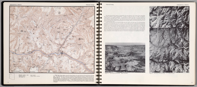
Full Title
Horizontal Strata. Bright Angel Ariz.
List No
0889.006
Note
Historical Geology. Contour map, with outline location map. Relief shown by contours and spot heightd. On the opposite page: text, and figures showing Grand Canyon of Colorado. (Space Air Photos), and Sterotriplet of the Grand Canyon. (U.S. Geological Survey).
Author
[Scovel, James L., O'Brien, Emmett J]
Full Title
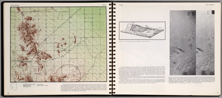
Fault Block. Old Age. Antelope Peak, Ariz. (on opposite page) Old Age. Stereopair of Antelope Peak, Arizona ... (inset) The Erosional cycle on an arid Fault Block.
List No
0889.027
Note
Contour map, and stereopair with text and outline location map. Relief shown by contours and spot height.
Author
[Scovel, James L., O'Brien, Emmett J]
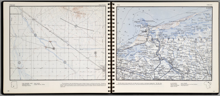
Full Title
Streams. Desert Streams. Casa Grande, Ariz. (on opposite page) Delta. El-Mansura. Egyptian Region, United Arab Republic. Scale 1:250,000.
List No
0889.054
Note
Two maps, with text, and location map. Relief shown by contours and spot heights.
Author
[Thomas Bros., Thomas Brothers]
Full Title
Highway Map State of Arizona.
List No
0994.013
Author
Vandermaelen, Philippe, 1795-1869
Full Title
Nouvelle Californie. Amer. Sep. no. 46. (with profile) Includes profile: Tableau physique de la pente Occidentale du Plateau de la nouvelle Espagne. Chemin de Mexico a Acapulco, d'apres A. de Humboldt. Dressee et dessinee par Ph. Vandermaelen. Desee. sur pierre et Lith. par H. Ode, juillet 1825.
List No
10068.000
Note
This is a variant edition - see our 2212.251. Hand col. lithographed map. Relief shown by hachures. Shows Indian tribes, Vancouver's route, etc. Covers parts of southern Nevada, Southern California, Arizona, Baja California Norte and Sonora. Includes text: Vielle Californie.
Author
[Delavault, A., Vandermaelen, Philippe, 1795-1869]
Full Title
Partie de Mexique. Amer. Sep. no. 47... 1825
List No
10069.000
Note
This is a variant and likely much earlier edition than our 2212.252. Substantial changes in the topography and a profile replaces the note. Hand col. lithographed map. Relief shown by hachures. Shows Indian tribes. Covers parts of Utah, Colorado and northern Arizona and New Mexico. Includes text: Note sur le Mexique. ... pour la suite de la note voir la carte no. 30. (Regidee par A. Delavault)
Author
[Touring club italiano, Funk & Wagnalls Company.]
Full Title
(Legend to) Stati Uniti, United States of America, California, Nevada, Utah, Arizona. Propr. Artistico-letteraria del T.C.I. Ufficio cartografico del T.C.I. (1929)
List No
1012CS
Note
Explanation to map.
Author
[Touring club italiano, Funk & Wagnalls Company.]
Full Title
Stati Uniti, United States of America, California, Nevada, Utah, Arizona. (with San Francisco, Oakland, Berkeley region). Propr. Artistico-letteraria del T.C.I. Ufficio cartografico del T.C.I. (1929)
List No
1012.075
Note
Color map. Relief shown by hachures and spot heights; depths by isolines. Inset map at 1:250,000 scale.
Author
[Touring club italiano, Funk & Wagnalls Company.]
Full Title
Stati Uniti, United States of America, Colorado, Kansas. (with San Francisco, Oakland, Berkeley region). Propr. Artistico-letteraria del T.C.I. Ufficio cartografico del T.C.I. (1929)
List No
1012.076
Note
Color map. Relief shown by hachures and spot heights. Includes inset map of the Grand Canyon at 1:1,000,000.
Author
Rheault, Jean-Louis
Full Title
Camp Verde Trail Map.
List No
10465.000
Author
U.S. General Land Office
Full Title
Sketch of Public Surveys in New Mexico & Arizona to accompany the Annual Report of the Commissioner of the General Land Office for 1866. Department of the Interior, General Land Office, October 2nd 1866. Jo. S. Wilson, Commissioner. The Major & Knapp Eng. Mfg. & Lith. Co., 71 Broadway, New York. Ho. Reps. Ex. Doc. No. 1, 37th Cong. 3d. Sess.
List No
1070.017
Note
Map in outline color. Gold, silver, and copper mines are prominently shown.
Author
U.S. General Land Office
Full Title
(Map 14 - California, Arizona, Nevada).
List No
1071.016
Note
One of the series of adjacent sixteen maps. Mounted on linen. Relief shown in hachures.
Author
[Birdseye, C.H., Burchard, R.W., U.S. Geological Survey]
Full Title
Sheet O. Plan and Profile of Colorado River From Lees Ferry, Ariz., To Black Canyon, Ariz.-Nev., and Virgin River, Nev. 21 Sheets (14 plans, 7 profiles).
List No
10974.016
Author
[Birdseye, C.H., Burchard, R.W., U.S. Geological Survey]
Full Title
Sheet P. Plan and Profile of Colorado River From Lees Ferry, Ariz., To Black Canyon, Ariz.-Nev., and Virgin River, Nev. 21 Sheets (14 plans, 7 profiles).
List No
10974.017
Author
[Birdseye, C.H., Burchard, R.W., U.S. Geological Survey]
Full Title
Sheet Q. Plan and Profile of Colorado River From Lees Ferry, Ariz., To Black Canyon, Ariz.-Nev., and Virgin River, Nev. 21 Sheets (14 plans, 7 profiles).
List No
10974.018
Author
[Birdseye, C.H., Burchard, R.W., U.S. Geological Survey]
Full Title
Sheet R. Plan and Profile of Colorado River From Lees Ferry, Ariz., To Black Canyon, Ariz.-Nev., and Virgin River, Nev. 21 Sheets (14 plans, 7 profiles).
List No
10974.019
Author
[Birdseye, C.H., Burchard, R.W., U.S. Geological Survey]
Full Title
Sheet S. Plan and Profile of Colorado River From Lees Ferry, Ariz., To Black Canyon, Ariz.-Nev., and Virgin River, Nev. 21 Sheets (14 plans, 7 profiles).
List No
10974.020
Author
[Birdseye, C.H., Burchard, R.W., U.S. Geological Survey]
Full Title
Sheet T. Plan and Profile of Colorado River From Lees Ferry, Ariz., To Black Canyon, Ariz.-Nev., and Virgin River, Nev. 21 Sheets (14 plans, 7 profiles).
List No
10974.021
Author
[Birdseye, C.H., Burchard, R.W., U.S. Geological Survey]
Full Title
Sheet U. Plan and Profile of Colorado River From Lees Ferry, Ariz., To Black Canyon, Ariz.-Nev., and Virgin River, Nev. 21 Sheets (14 plans, 7 profiles).
List No
10974.022
Author
[Prescott Chamber of Commerce, Yavapai County Board of Supervisors]
Full Title
Prescott : Mile high city of health, center of the nation's greatest concentration of varied natural attractions. (Cover title) Prescott center of Yavapai : Heart of the nation's greatest concentration of varied natural attractions.
List No
11060.002
Note
Color pictorial map of the Prescott Arizona Yavapai county, on sheet 28.5x43, folded into self wrapped cover, 22x9. borders with places of interests. Map showing roads, streets, parks, wildlife, buildings, recreational activities and public places. Includes key to map, places of interest. On verso of map and recto of cover title: text and photographs of scenic views. Date estimated.
Author
Lindgren, Jolly
Full Title
A Hysterical Map of the Grand Canyon National Park. A mile deeper and everso wide. Where mother nature started from scratch. Drawn in broken english by Jolly Lindgren, (Copyright) 1940. By Lindgren Brothers - Spokane, Wash. (Envelope title) Here's another hysterical map.
List No
11092.002
Note
Pictorial map of Grand Canyon. Placed in an Envelope 10.5 x24, with return address. This is an enhanced version of the map, with same publication date. Published in smaller size, and with different note at bottom panel: " Where Mother nature started form scratch", which in previous version the note on bottom panel reads: "A swell place to throw your old razor blades". Map filled with humorous notes, showing roads, trails, trees, and places of interest. Includes legend and Compass rose. Relief shown by hachures and pictorially.
Author
Lindgren - Turner Co.
Full Title
Arizona : "The Grand Canyon state. A-1. Lindgren - Turner Co. W. 902 Broadway. Spokane, 1, Wash.
List No
11097.002
Note
Pictorial postcard of Arizona in brilliant full-color and high detail, 11x8, the travel decal manufactured by Lindgren - Turner Co. Printed on ultra-heavyweight paper, with a gloss finish, come packaged in a cellophane sleeve, with instruction to apply, in black printing on the back, with notes and advertisements. It shows a beautiful map with place names and tourist attractions. Date estimated. Relief shown pictorially.
Author
U.S. General Land Office
Full Title
Department of the Interior, General Land Office. S.S. Burdett, Commissioner. Territory of Arizona. 1876. Compiled from the official records of the General Land Office and other sources by C. Roeser, Principal Draughtsman G.L.O. Photolith. & Print by Julius Bien 16 & 18 Park Place, N.Y.
List No
11179.011
Note
Color map. Includes references. Relief shown by hachures.
|