|
REFINE
Browse All : Images of Arizona from 1944
1-4 of 4
Author
State Farm Insurance Companies Travel Bureau
Full Title
State Farm Road map: Arizona, New Mexico. Copyright by Rand McNally & Company, Chicago, Ill. Lithographed in U.S.A. Z.3627. (on upper corners) Ariz. N. Mex.
List No
4246.013
Note
Color map. Shows roads, points of interest, distances, time zone boundaries, populations, etc. U.S. interstate and principal state highways shown in red. Relief shown by hachures.
Author
[U.S. Coast and Geodetic Survey, United States. Department of Commerce]
Full Title
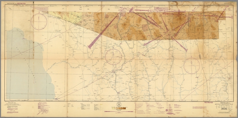
Sectional Aeronautical Chart. Douglas (P-3). Compiled and printed at Washington, D.C. by U.S. Coast and Geodetic Survey under authority of the Secretary of Commerce. Principal sources: Mexican Government, U.S. Geological Survey, Civil Aeronautics Administration and the U.S. Coast and Geodetic Survey. Feb. 17, 1944.
List No
9908.000
Note
Sectional Aeronautical Chart. Douglas (P-3) sheet. 44-2, 44-8 at lower left. Lambert Conformal Conic projection. Relief shown by contours, spot heights and gradient tints. "Restricted" at upper left and lower right margins. Coverage includes portions of Arizona and New Mexico. Portions of Mexico not mapped. Includes index to published adjoining sheets 1:500,000 sectional aeronautical charts, legend, insignia of U.S. Dept. of Commerce and gradient of elevation chart. Shows roads, railroads, airfields, civil airports, radio ranges and stations, cities. towns, etc.
Author
[U.S. Coast and Geodetic Survey, United States. Department of Commerce]
Full Title
Sectional Aeronautical Chart. Phoenix (Q-3). Compiled and printed at Washington, D.C. by U.S. Coast and Geodetic Survey under authority of the Secretary of Commerce. Principal sources: U.S. Geological Survey, Civil Aeronautics Administration and the U.S. Coast and Geodetic Survey. Mar. 2, 1944.
List No
9910.000
Note
Sectional Aeronautical Chart. Phoenix (Q-3) sheet. Lambert Conformal Conic projection. Relief shown by contours and spot heights. "Restricted" at upper right and lower left margins. Includes index to published adjoining sheets 1:500,000 sectional aeronautical charts, legend, insignia of U.S. Dept. of Commerce and gradient of elevation chart. Shows roads, railroads, airfields, civil airports, radio ranges and stations, cities. towns, etc.
Author
[U.S. Coast and Geodetic Survey, United States. Department of Commerce]
Full Title
Sectional Aeronautical Chart. Roswell (Q-4). Compiled and printed at Washington, D.C. by U.S. Coast and Geodetic Survey under authority of the Secretary of Commerce. Principal sources: U.S. Geological Survey, U.S. Dept. of Agriculture, Civil Aeronautics Administration and the U.S. Coast and Geodetic Survey. Aug. 24, 1944.
List No
9911.000
Note
Sectional Aeronautical Chart. Phoenix (Q-3) sheet. Lambert Conformal Conic projection. Relief shown by contours and spot heights. "Restricted" at upper right and lower left margins. Includes index to published adjoining sheets 1:500,000 sectional aeronautical charts, legend, insignia of U.S. Dept. of Commerce and gradient of elevation chart. Shows roads, railroads, airfields, civil airports, radio ranges and stations, cities. towns, etc.
1-4 of 4
|