|
REFINE
Browse All : Images of Arizona and New Mexico and United States
1-10 of 10
Author
Mitchell, Samuel Augustus Jr.
Full Title
Arizona and New Mexico. Entered ... 1867 by S. Augustus Mitchell, Jr. ... Pennsylvania.
List No
0579.044
Note
Color map by state and county. Relief shown by hachures. Prime meridians are Greenwich and Washington, D.C.
Author
Stieler, Adolf, 1775–1836
Full Title
Die Vereinigten Staaten Von Nord-Amerika In 6 Blattern. Von A. Petermann. Bearbeitet v. H. Habenicht. Gest v. Eberhardt, Kuhn, Metzeroth & Weiler. Stieler's Hand-Atlas No. 84. Gotha: Justus Perthes. 1875.
List No
13563.107
Note
1 outline color map on 6 sheets. Sheet 4. Title from sheet 4. Shows Arizona, Part of California, Nevada, Utah, Colorado, New Mexico, and northern Mexico.
Author
Rand McNally and Company
Full Title
(Text Page) Rand, McNally Co.'s New Mexico. Rand, McNally Co.'s Arizona.
List No
2844DW
Note
Tables of railroads and geographical features keyed to map.
Author
National Map Company
Full Title
Arizona and New Mexico. (Copyrighted by) National Map Company, Indianapolis. (to accompany) Official Paved Road and Commercial Survey of the United States.
List No
4048.056
Note
Outline color map. Shows administrative divisions, roads, rivers, etc. Relief shown by hachures. Prime meridian is Greenwich.
Author
Colton, G.W.
Full Title
Territories of New Mexico and Utah (and Nevada and Arizona). No. 51. Published by J.H. Colton & Co., No 172 William St., New York. Entered according to the Act of Congress in the year 1855 by J.H. Colton & Co. in the Clerk's Office of the District Court of the United States for the Southern District of New York.
List No
5479.099
Note
Meridians Washington and Greenwich. Counties tinted in color. Relief shown with hachures. Shows settlements and routes of exploration including proposed railroad routes.
Author
Marbut, Curtis F.
Full Title
Soil Map of the United States by Curtis F. Marbut and Associates in the Soil Survery, U.S. Department of Agriculture, F.J. Marschner, Cartographer and Associate in Compilation. 1931. Soils, Plate 5, Section 6. Lith. A. Hoen & Co., Inc. Atlas of American Agriculture.
List No
5797.092
Note
Includes legend of 12 map sections. Includes soils legend for this section and landscape photographs.
Author
Marbut, Curtis F.
Full Title
Soil Map of the United States by Curtis F. Marbut and Associates in the Soil Survery, U.S. Department of Agriculture, F.J. Marschner, Cartographer and Associate in Compilation. 1931. Soils, Plate 5, Section 11. Lith. A. Hoen & Co., Inc. Atlas of American Agriculture.
List No
5797.112
Note
Includes legend of 12 map sections. Includes soils legend for this section and landscape photographs.
Author
[Rand McNally and Company, State Farm Insurance Companies Travel Bureau]
Full Title
Rand McNally Road map: Arizona, New Mexico. Copyright by Rand McNally & Company, Chicago, Ill. Lithorgaphed in the U.S.A. U.3627. (to accompany) State Farm road atlas : United States, Canada, Mexico.
List No
6825.017
Note
Color map. U.S. interstate highways shown in red. Shows time zone boundaries, roads, ferries, highways, rivers and streams. Includes population of cities and towns. Relief shown by hachures.
Author
[U.S. Coast and Geodetic Survey, United States. Department of Commerce]
Full Title
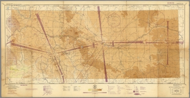
Sectional Aeronautical Chart. Prescott (R-3). Compiled and printed at Washington, D.C. by U.S. Coast and Geodetic Survey under authority of the Secretary of Commerce. Principal sources: U.S. Geological Survey, U.S. Dept. of Agriculture, Civil Aeronautics Administration and the U.S. Coast and Geodetic Survey. Mar. 1, 1945.
List No
9907.000
Note
Sectional Aeronautical Chart. Prescott (R-3) sheet. Lambert Conformal Conic projection. Relief shown by contours, spot heights and gradient tints. "Restricted" at upper right and lower left margins. Coverage includes portions of Arizona and New Mexico. Includes index to published adjoining sheets 1:500,000 sectional aeronautical charts, legend, insignia of U.S. Dept. of Commerce and gradient of elevation chart. Shows roads, railroads, airfields, civil airports, radio ranges and stations, cities. towns, etc.
Author
[U.S. Coast and Geodetic Survey, United States. Department of Commerce]
Full Title
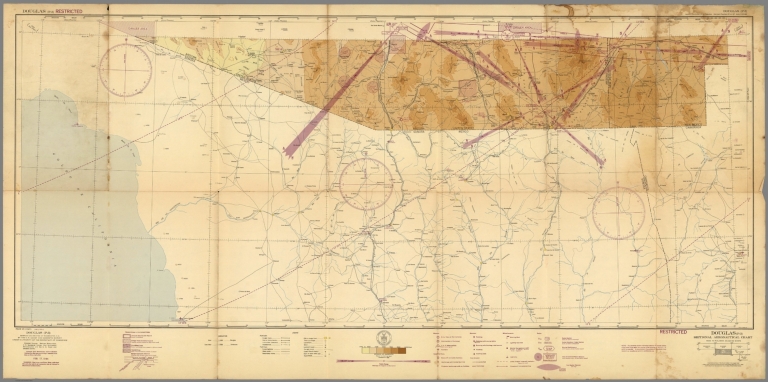
Sectional Aeronautical Chart. Douglas (P-3). Compiled and printed at Washington, D.C. by U.S. Coast and Geodetic Survey under authority of the Secretary of Commerce. Principal sources: Mexican Government, U.S. Geological Survey, Civil Aeronautics Administration and the U.S. Coast and Geodetic Survey. Feb. 17, 1944.
List No
9908.000
Note
Sectional Aeronautical Chart. Douglas (P-3) sheet. 44-2, 44-8 at lower left. Lambert Conformal Conic projection. Relief shown by contours, spot heights and gradient tints. "Restricted" at upper left and lower right margins. Coverage includes portions of Arizona and New Mexico. Portions of Mexico not mapped. Includes index to published adjoining sheets 1:500,000 sectional aeronautical charts, legend, insignia of U.S. Dept. of Commerce and gradient of elevation chart. Shows roads, railroads, airfields, civil airports, radio ranges and stations, cities. towns, etc.
1-10 of 10
|