|
REFINE
Browse All : Images of Arizona and Nevada and California
1-26 of 26
Author
Bancroft, A.L.
Full Title
Bancroft's Map Of California, Nevada, Utah And Arizona. Published By A.L. Bancroft & Compy. Booksellers & Stationers, San Francisco, Cal. 1873. Entered ... by A.L. Bancroft & Company ... Washington, D.C.
List No
0046.000
Note
1st edition was 1864. From Bancroft's Map the of Pacific States which appeared in 1863. Wheat says Bancroft changed the large Pacific States map in 1870, but we believe that the smaller maps such as this continue to be from the original 1863 or 1867 plates, updated to show railroad expansion and topographical changes. With black top and bottom rollers. Full color by county.
Author
[Bancroft, A.L., Knight, W.H.]
Full Title
(Covers to) Bancroft's Map Of California, Nevada, Utah And Arizona. Published By A.L. Bancroft, & Compy. Booksellers & Stationers San Francisco Cal. 1876. Entered ... by A.L. Bancroft & Company ... Washington, D.C.
List No
0047.001
Note
Additional railroads when compared to the 1873 edition. Full color by county. Folded into dark brown cloth covers 16x11 with title "Bancroft's Map Of California, Nevada, Utah & Arizona." in gold. Relief shown by hachures.
Author
[Bancroft, A.L., Knight, W.H.]
Full Title
Bancroft's Map Of California, Nevada, Utah And Arizona. Published By A.L. Bancroft, & Compy. Booksellers & Stationers San Francisco Cal. 1876. Entered ... by A.L. Bancroft & Company ... Washington, D.C.
List No
0047.002
Note
Additional railroads when compared to the 1873 edition. Full color by county. Folded into dark brown cloth covers 16x11 with title "Bancroft's Map Of California, Nevada, Utah & Arizona." in gold. Relief shown by hachures.
Author
Colton, G.W.
Full Title
Colton's Map of California, Nevada, Utah, Colorado, Arizona & New Mexico. Published By J. H. Colton. No. 172 William St. New York.
List No
0151.062
Note
Shows routes, dates of exploration and the explorers. Prime meridians are Greenwich and Washington D.C. Relief shown by hachures
Author
Johnson, A.J.
Full Title
Johnson's California also Utah, Nevada, Colorado, New Mexico, and Arizona. Entered ... 1864.
List No
0358.049
Author
Vandermaelen, Philippe, 1795-1869
Full Title
Nouvelle Californie. Amer. Sep. no. 46. (with profile) Includes profile: Tableau physique de la pente Occidentale du Plateau de la nouvelle Espagne. Chemin de Mexico a Acapulco, d'apres A. de Humboldt. Dressee et dessinee par Ph. Vandermaelen. Desee. sur pierre et Lith. par H. Ode, juillet 1825.
List No
10068.000
Note
This is a variant edition - see our 2212.251. Hand col. lithographed map. Relief shown by hachures. Shows Indian tribes, Vancouver's route, etc. Covers parts of southern Nevada, Southern California, Arizona, Baja California Norte and Sonora. Includes text: Vielle Californie.
Author
[Touring club italiano, Funk & Wagnalls Company.]
Full Title
(Legend to) Stati Uniti, United States of America, California, Nevada, Utah, Arizona. Propr. Artistico-letteraria del T.C.I. Ufficio cartografico del T.C.I. (1929)
List No
1012CS
Note
Explanation to map.
Author
[Touring club italiano, Funk & Wagnalls Company.]
Full Title
Stati Uniti, United States of America, California, Nevada, Utah, Arizona. (with San Francisco, Oakland, Berkeley region). Propr. Artistico-letteraria del T.C.I. Ufficio cartografico del T.C.I. (1929)
List No
1012.075
Note
Color map. Relief shown by hachures and spot heights; depths by isolines. Inset map at 1:250,000 scale.
Author
U.S. General Land Office
Full Title
(Map 14 - California, Arizona, Nevada).
List No
1071.016
Note
One of the series of adjacent sixteen maps. Mounted on linen. Relief shown in hachures.
Author
Berghaus, Hermann
Full Title
Nord-Amerika. Ubersicht von Nord-Amerika. (with) Virginia-Silber-Minen. (with) Das Yosemite-Thal. (with) Landenge von Tehuantepec n. J.C. Spear 1871. (with) Landenge von Nicaragua. (with) Die Krater des Turrialba. (with) Landenge von Panama. (with) Seeboden der New-York-Bay. (with) Popocatepetl. (with) Citlaltepetl. (with) Canons des Colorado. (with) Yellowstone-National-Park. (with) Reykjanes und Geyser nach Th. Thoroddsen. Entw. v. Herm. Berghaus 1886, Ausg. 1887. Nebenkarten gez. v. M. Risch. Gotha: Justus Perthes (1892)
List No
1578.012
Note
Lithographed geologic map, color with 12 inset maps. Relief shown by spot heights. Some inset maps are topographic maps showing relief by hachures and spot heights.
Author
Vandermaelen, Philippe, 1795-1869
Full Title
Partie de la Vielle Californie. Amer. Sep. no. 53. Dressee et dessinee par Ph. Vandermaelen. Lith par H. Ode. Aout 1824. (Quatrieme partie. - Amer. sept. Bruxelles. 1827)
List No
2212.258
Note
Hand col. lithographed map. Relief shown by hachures. Shows Indian tribes, Vancouver's route, etc. Covers parts of southern Nevada, Southern California, Arizona, Baja California Norte and Sonora. Includes text: Vielle Californie.
Author
Wheeler, G.M.
Full Title
Atlas Sheet Number 58. Parts Of E. California, S.E. Nevada, N.W. Arizona & S.W. Utah. Atlas Sheet Number 66. Weyss, Herman & Aguirre, Del. Expeditions of 1872 & 1873, Under the Command of 1st. Lieut. Geo. M. Wheeler, Corps of Engineers, U.S. Army. Geological Assistants: G.K. Gilbert, A.R. Marvine and E.E. Howell. U.S. Geographical Surveys West Of The One-Hundredth Meridian.
List No
2738.045
Note
Two partial atlas sheets on one page. In crayon and showing geological formations in tints. Color legend on outside of each map.
Author
[Wheeler, G.M., Bergland, Eric]
Full Title
Topographical Sketch showing the Outward and Inward Route of a Party, while examining as to the practicability of a Diversion of the Colorado River for Purposes of Irrigation... 1875. Geographical Surveys West Of The 100th Meridian.
List No
2738.122
Note
Shows the Colorado River in parts of California, Nevada, and Arizona. From a Wheeler Annual Report. Gift to the collection by Mark Sappington.
Author
U.S. War Department, Chief of Engineers
Full Title
Map Of California And Nevada, With Parts Of Utah & Arizona. Prepared in the Office of the Chief Of Engineers U.S.A. 1879.
List No
3360.000
Note
A larger version of a portion of the Freyhold/Warren U.S. of 1879. Wheat mentions this map in the same paragraph as the Freyhold/Warren map but he does not notice that they are from the same map! Wheat calls this map "certainly a major map of this large area..." Issued on thin paper for field use. Paper is watermarked "Crane Co. 1885." Map is without color.
Author
Lloyd, H.H.
Full Title
County map of California and Nevada. County map of Arizona and Southern California. (to accompany) Lloyd's Handy Atlas ... Published By D.L. Guernsey, Concord, N.H. 1874. Entered ... 1872, by H.H. Lloyd, & Co. ... Washington.
List No
4474.025
Note
2 outline hand colored maps. Showing administrative boundaries, numerous cities, railroads, roads, rivers, and mountains. Relief shown by hachures. Prime meridians are Greenwich and Washington.
Author
Cram, George Franklin
Full Title
New Rail Road and County Map of Southern California and Arizona.
List No
4558.058
Author
[Bourquin, Frederick, Mitchell, Samuel Augustus, Tanner, Henry S.]
Full Title
Oregon, Upper California & New Mexico. Published by S. Augustus Mitchell, N.E. Corner of Market & 7th. Streets Philadelphia. 1849. Entered according to Act of Congress in the 1845 by H.N. Burroughs - in the Clerk's Office of the Eastern District of Penna. 36.
List No
4578.037
Note
Revision of Mitchell's 1846-1847 maps with title: Oregon and Upper California. Coverage is extended eastward to include New Mexico and part of Missouri Territory. Mexican boundary added. Relief shown by hachures and spot heights. Uncolored. "Oregon" and "Upper or New California" in bold type. Shows Indian tribes and includes descriptive notes. New California extends to the Gulf of California. Prime meridians: Greenwich and Washington. Lithographed. Trails, roads, and rivers shown. Shows the Great Spanish Trail, Oregon Route and Lewis and Clark's Route.
Author
[Bancroft, H.H., Knight, W.H.]
Full Title
(Covers to) Bancroft's Map Of California, Nevada, Utah And Arizona. Published By H.H. Bancroft, & Compy. Booksellers & Stationers San Francisco Cal. 1864. Entered ... 1863 by H.H. Bancroft & Company ... California.
List No
4819.001
Note
First edition, first issue of this map. Entered in 1863 and taken from Bancroft's large Map of the Pacific States of 1864, the second edition (first issued in 1863). All of California and Nevada are shown, along with the western parts of Utah and Arizona. A companion map was issued in the same year covering the northern parts of the Pacific States map: Washington, Oregon, Idaho, and Montana. This is the scarcest of the editions of this map. A second issue was published in the same year, with a different border (interlocking leaves as opposed to interlocking Coltonesque metal strips in this copy), with a clean up of various names that were cut off in this first issue along the northern and eastern borders when the plate was extracted from the large map (for instance, "Painted De" for Painted Desert appears at the 35th parallel on the eastern border of Arizona in the first issue and is removed in the second issue) and different labeling of the railroads (see our 4820). To the right of the title the Colton Company name is embossed: G.W. & C.B. Colton & Co. Publishers Of Maps, Atlases, Etc. 172 William Street. N.Y. Map is full color by county and folded into stamped lavender cloth covers 16x10.5 with "Bancroft's Map Of California, Nevada, Utah And Arizona." in gilt. Prime meridians are Greenwich and Washington D.C. Relief shown by hachures.
Author
[Bancroft, H.H., Knight, W.H.]
Full Title
Bancroft's Map Of California, Nevada, Utah And Arizona. Published By H.H. Bancroft, & Compy. Booksellers & Stationers San Francisco Cal. 1864. Entered ... 1863 by H.H. Bancroft & Company ... California.
List No
4819.002
Note
First edition, first issue of this map. Entered in 1863 and taken from Bancroft's large Map of the Pacific States of 1864, the second edition (first issued in 1863). All of California and Nevada are shown, along with the western parts of Utah and Arizona. A companion map was issued in the same year covering the northern parts of the Pacific States map: Washington, Oregon, Idaho, and Montana. This is the scarcest of the editions of this map. A second issue was published in the same year, with a different border (interlocking leaves as opposed to interlocking Coltonesque metal strips in this copy), with a clean up of various names that were cut off in this first issue along the northern and eastern borders when the plate was extracted from the large map (for instance, "Painted De" for Painted Desert appears at the 35th parallel on the eastern border of Arizona in the first issue and is removed in the second issue) and different labeling of the railroads (see our 4820). To the right of the title the Colton Company name is embossed: G.W. & C.B. Colton & Co. Publishers Of Maps, Atlases, Etc. 172 William Street. N.Y. Map is full color by county and folded into stamped lavender cloth covers 16x10.5 with "Bancroft's Map Of California, Nevada, Utah And Arizona." in gilt. Prime meridians are Greenwich and Washington D.C. Relief shown by hachures.
Author
Bancroft, H.H.
Full Title
(Covers to) Bancroft's Map Of California, Nevada, Utah And Arizona. Published By H.H. Bancroft, & Compy. Booksellers & Stationers San Francisco Cal. 1864. Entered ... 1863, by H.H. Bancroft & Company ... California.
List No
4820A
Author
Bancroft, H.H.
Full Title
Bancroft's Map Of California, Nevada, Utah And Arizona. Published By H.H. Bancroft, & Compy. Booksellers & Stationers San Francisco Cal. 1864. Entered ... 1863, by H.H. Bancroft & Company ... California.
List No
4820.001
Note
First edition, second issue of this map with a different border and small changes in the map (see notes to our #4819). Full color by county. Folded into stamped brown cloth covers 16x10.5 with "Bancroft's Map Of California, Nevada, Utah And Arizona." in gilt.
Author
Colton, G.W.
Full Title
Colton's Map of California, Nevada, Utah, Colorado, Arizona & New Mexico. Published by G.W. & C.B. Colton & Co., No. 172 William St. New York.
List No
4825.060
Note
Shows routes, dates of exploration and the explorers. Prime meridians are Washington D.C. and Greenwich. Relief shown by hachures
Author
Schonberg & Co.
Full Title
Schonberg's Map of California, Oregon & Nevada with Part of Idaho, Utah & Arizona. Entered ... 1866 .. New York.
List No
5198.004
Note
Counties differentiated by color. Prime meridians Greenwich and Washington D.C. Relief shown by hachures.
Author
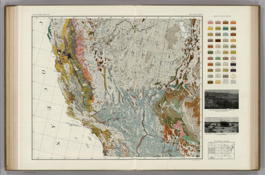
Marbut, Curtis F.
Full Title
Soil Map of the United States by Curtis F. Marbut and Associates in the Soil Survery, U.S. Department of Agriculture, F.J. Marschner, Cartographer and Associate in Compilation. 1931. Soils, Plate 5, Section 5. Lith. A. Hoen & Co., Inc. Atlas of American Agriculture.
List No
5797.091
Note
Includes legend of 12 map sections. Includes soils legend for this section and landscape photographs.
Author
Bancroft, A.L.
Full Title
Bancroft's Map Of California, Nevada, Utah And Arizona. Published By A.L. Bancroft & Compy. Booksellers & Stationers, San Francisco, Cal. 1871. Entered ... by A.L. Bancroft & Company ... Washington, D.C.
List No
5867.000
Note
Compare to the 1873 edition, several differences. Full color by county.
Author
W. & A.K. Johnston Limited
Full Title
California (North), Nevada, Oregon (South). California (South), Nevada (South), Arizona (West).
List No
6921.130
1-26 of 26
|