|
REFINE
Browse All : Images of Arizona and California
1-66 of 66
Author
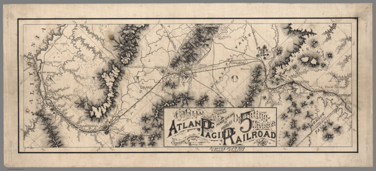
Atlantic & Pacific Railroad
Full Title
Map of the 5th Operating Division of the Western Division, Atlantic & Pacific R.R., From Peach Springs to Needles. W.A. Drake, Acting Chief Engineer. Drawing No. J-2-902.
List No
6929.005
Note
No drawing on verso. A set of six hand-drawn maps on semi-transparent waxed linen with some color. Some areas are colored on the verso to highlight the areas in a muted style. We think that some type of backlighting was planned to be used to create a photolithographic plate from which printing would be done. No evidence was found that it was ever printed. These sheets were deaccessioned from the Santa Fe Railroad collection in the 1980s. Lewis Kingman did the route survey from Albuquerque to Needles. Relief shown by hachures.
Author
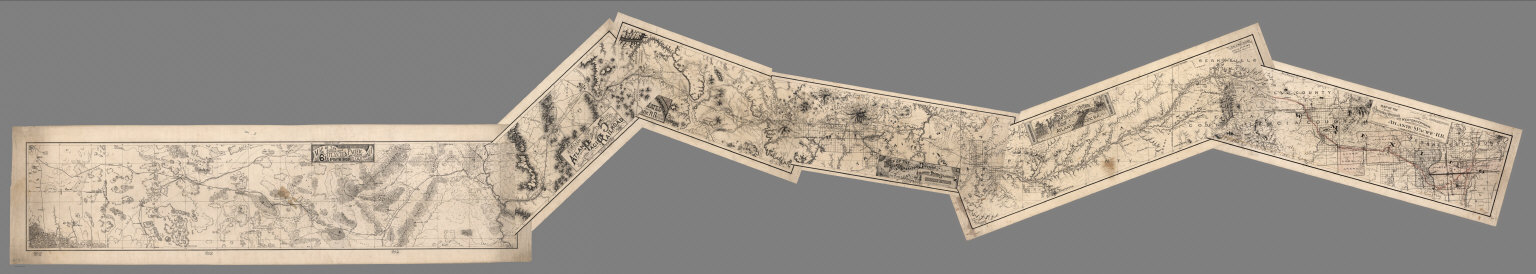
Atlantic & Pacific Railroad
Full Title
(Composite of) Maps of the First through Sixth Operating Divisions of the Western Division, Atlantic & Pacific Railroad, Albuquerque, New Mexico, to Mojave (Mohave), California.
List No
6929.007
Note
Composite of all six maps joined together end to end. This is a set of six hand-drawn maps on semi-transparent waxed linen with some color. Some areas are colored on the verso to highlight the areas in a muted style. We think that some type of backlighting was planned to be used to create a photolithographic plate from which printing would be done. No evidence was found that it was ever printed. These sheets were deaccessioned from the Santa Fe Railroad collection in the 1980s. Lewis Kingman did the route survey from Albuquerque to Needles. Relief shown by hachures.
Author
Bancroft, A.L.
Full Title
Bancroft's Map Of California, Nevada, Utah And Arizona. Published By A.L. Bancroft & Compy. Booksellers & Stationers, San Francisco, Cal. 1873. Entered ... by A.L. Bancroft & Company ... Washington, D.C.
List No
0046.000
Note
1st edition was 1864. From Bancroft's Map the of Pacific States which appeared in 1863. Wheat says Bancroft changed the large Pacific States map in 1870, but we believe that the smaller maps such as this continue to be from the original 1863 or 1867 plates, updated to show railroad expansion and topographical changes. With black top and bottom rollers. Full color by county.
Author
[Bancroft, A.L., Knight, W.H.]
Full Title
(Covers to) Bancroft's Map Of California, Nevada, Utah And Arizona. Published By A.L. Bancroft, & Compy. Booksellers & Stationers San Francisco Cal. 1876. Entered ... by A.L. Bancroft & Company ... Washington, D.C.
List No
0047.001
Note
Additional railroads when compared to the 1873 edition. Full color by county. Folded into dark brown cloth covers 16x11 with title "Bancroft's Map Of California, Nevada, Utah & Arizona." in gold. Relief shown by hachures.
Author
[Bancroft, A.L., Knight, W.H.]
Full Title
Bancroft's Map Of California, Nevada, Utah And Arizona. Published By A.L. Bancroft, & Compy. Booksellers & Stationers San Francisco Cal. 1876. Entered ... by A.L. Bancroft & Company ... Washington, D.C.
List No
0047.002
Note
Additional railroads when compared to the 1873 edition. Full color by county. Folded into dark brown cloth covers 16x11 with title "Bancroft's Map Of California, Nevada, Utah & Arizona." in gold. Relief shown by hachures.
Author
Colton, G.W.
Full Title
Colton's Map of California, Nevada, Utah, Colorado, Arizona & New Mexico. Published By J. H. Colton. No. 172 William St. New York.
List No
0151.062
Note
Shows routes, dates of exploration and the explorers. Prime meridians are Greenwich and Washington D.C. Relief shown by hachures
Author
Colton, G.W.
Full Title
Colton's Map of California, Nevada, Utah, Colorado, Arizona and New Mexico. Published By G. W & C. B. Colton & Co. No. 172 William St. New York.
List No
0152.064
Note
Prime meridians are Washington D.C. and Greenwich.
Author
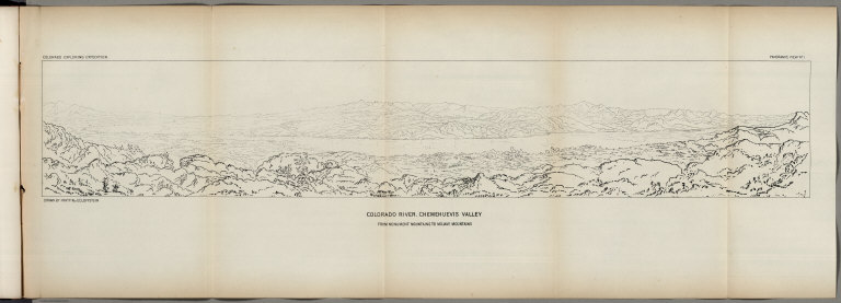
Ives, J.C.
Full Title
Colorado River. Chemehuevis Valley, From Monument Mountains to Mojave Mountains. Colorado Exploring Expedition. Panoramic View No. 1. Drawn by Frhr. F.W. v. Ecloffstein.
List No
0341.015
Author
Ives, J.C.
Full Title
Fig 1. - Yuma Shoals.
List No
0341.016
Author
Ives, J.C.
Full Title
Fig 2. - Explorer's Pass.
List No
0341.017
Author
Ives, J.C.
Full Title
Fig 3. - Purple Hills.
List No
0341.018
Author
Ives, J.C.
Full Title
Cane Brake Canyon, from near Camp 16. Colorado Exploring Expedition. General Report - Plate II. J.J. Young from a sketch by F.W. Egloffstein. Lith Sarony, Major & Knapp, 449 Broadway N.Y.
List No
0341.019
Author
Ives, J.C.
Full Title
Fig 4. - Purple Hills Pass.
List No
0341.020
Author
Ives, J.C.
Full Title
Fig 5. - Red Rock Gate.
List No
0341.021
Author
Ives, J.C.
Full Title
Fig 6. - Sleeper's Bend.
List No
0341.022
Author
Ives, J.C.
Full Title
Fig 7. - Light-house Rock.
List No
0341.023
Author
Ives, J.C.
Full Title
Fig 8. - Riverside Mountains.
List No
0341.024
Author
Ives, J.C.
Full Title
Chemehuevis. Colorado Exploring Expedition. Indian Portraits, Plate III. B. Mollhausen, Del. Lith. of Sarony, Major & Knapp, 449 Broadway N.Y.
List No
0341.025
Note
Color.
Author
Ives, J.C.
Full Title
Fig 9. - Monument Mountains.
List No
0341.026
Author
Ives, J.C.
Full Title
Fig 10. - Corner Rock.
List No
0341.027
Author
Ives, J.C.
Full Title
Fig 11. - Monument Canyon.
List No
0341.028
Author
Ives, J.C.
Full Title
Fig 12. - Monument Range from the North.
List No
0341.029
Author
Ives, J.C.
Full Title
Fig 13. - Mount Whipple.
List No
0341.030
Author
Ives, J.C.
Full Title
Fig 14. - Remains of Grand Mesa in Chemehuevis Valley.
List No
0341.031
Author
Ives, J.C.
Full Title
Mojave Canon. Colorado Exploring Expedition. General Report, Plate III. J.J. Young from a sketch by H.B. Mollhausen, Del.
List No
0341.032
Author
Ives, J.C.
Full Title
Fig 15. - Mouth of Mojave Canon.
List No
0341.033
Note
Page has a large block of foxing.
Author
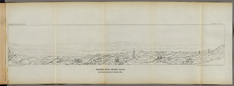
Ives, J.C.
Full Title
Colorado River. Mojave Valley, From Mojave Mountains to Pyramid Canon. Colorado Exploring Expedition. Panoramic View No. 2. Drawn by Frhr. F.W. v. Ecloffstein. Lith. of Sarony Major & Knapp, 449 Broadway N.Y.
List No
0341.034
Author
Ives, J.C.
Full Title
Fig 16. - Head of Mojave Canon.
List No
0341.035
Author
Ives, J.C.
Full Title
The Needles (Mojave Range). Colorado Exploring Expedition. Geology, Plate II. J.J. Young from a sketch by H.B. Mollhausen. Lith. of Sarcony, Major & Knapp, 449 Broadway N.Y.
List No
0341.086
Author
Ives, J.C.
Full Title
Fig 10. Section of Trough of Colorado at Elephant Hill.
List No
0341.090
Author
Johnson, A.J.
Full Title
Johnson's California also Utah, Nevada, Colorado, New Mexico, and Arizona. Entered ... 1864.
List No
0358.049
Author
Johnson, A.J.
Full Title
Johnson's California, With Utah, Nevada, Colorado, New Mexico And Arizona Published By Johnson and Ward.
List No
0535.041
Note
In full color. Various routes shown: Proposed Central Pacific Railroad, Proposed Union Pacific Railroad, Pacific Railroad, Pony Express, Emigrant Road, Simpson 1859, Fremont 1845, Fremont 1844, Fremont 1843, Spanish Trail from Los Angeles to Albiguia New Mexico, Spainish Trail from Salt Lake to Santa Fe, Captain Gunnison 1855, Captain Sitgreaves 1951, Major Emory 1846, El Paso Waggon (Wagon) Road, Cimarron Route to Fort Leavenworth, Colonel Washington, etc. Delineates various Indian lands. Shows Head of Navigation on the Colorado River at the confluence with the Virgin River. Relief shown by hachures. Meridians Greenwich and Washington D.C.
Author
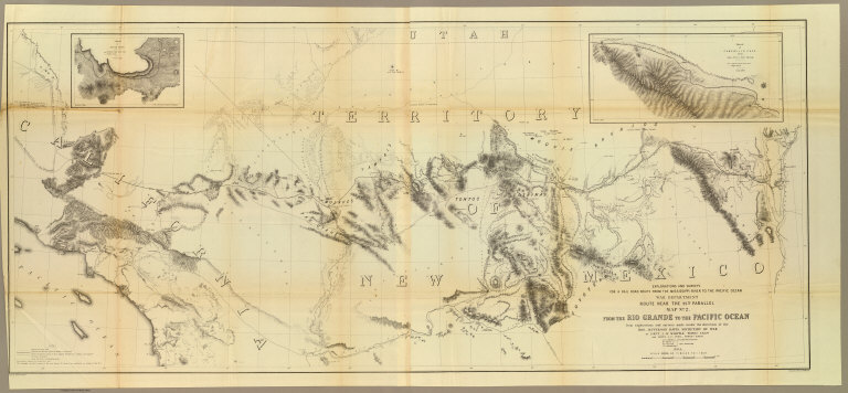
[Ives, J.C., Whipple, A.W.]
Full Title
From the Rio Grande to the Pacific Ocean from explorations and surveys made under the direction of the Hon. Jefferson Davis, Secretary of War by Lieut. A.W. Whipple, Topogl. Engrs. and Lieut. J.C. Ives, Topogl. Engrs. A.H. Campbell, Civil Eng. and Surveyor, Asst. Surveyors: Wm. White Jr., N.H. Hutton, and J.P. Sherburne. 1853-4. Explorations and Surveys for a Rail Road Route from the Mississippi River to the Pacific Ocean, War Department, Route Near the 35th Parallel, Map No. 2. Engr. by Selmar Siebert. Drawn by John D. Hoffmann.
List No
0693.038
Note
The uncolored map stretches from Albuquerque in the east across the southwest to Los Angeles. With two inset maps: "Sketch of Campbell's Pass from Agua Azul to Salt Spring" and "Sketch of Aztec Pass."
Author
Vandermaelen, Philippe, 1795-1869
Full Title
Nouvelle Californie. Amer. Sep. no. 46. (with profile) Includes profile: Tableau physique de la pente Occidentale du Plateau de la nouvelle Espagne. Chemin de Mexico a Acapulco, d'apres A. de Humboldt. Dressee et dessinee par Ph. Vandermaelen. Desee. sur pierre et Lith. par H. Ode, juillet 1825.
List No
10068.000
Note
This is a variant edition - see our 2212.251. Hand col. lithographed map. Relief shown by hachures. Shows Indian tribes, Vancouver's route, etc. Covers parts of southern Nevada, Southern California, Arizona, Baja California Norte and Sonora. Includes text: Vielle Californie.
Author
[Touring club italiano, Funk & Wagnalls Company.]
Full Title
(Legend to) Stati Uniti, United States of America, California, Nevada, Utah, Arizona. Propr. Artistico-letteraria del T.C.I. Ufficio cartografico del T.C.I. (1929)
List No
1012CS
Note
Explanation to map.
Author
[Touring club italiano, Funk & Wagnalls Company.]
Full Title
Stati Uniti, United States of America, California, Nevada, Utah, Arizona. (with San Francisco, Oakland, Berkeley region). Propr. Artistico-letteraria del T.C.I. Ufficio cartografico del T.C.I. (1929)
List No
1012.075
Note
Color map. Relief shown by hachures and spot heights; depths by isolines. Inset map at 1:250,000 scale.
Author
U.S. General Land Office
Full Title
(Map 14 - California, Arizona, Nevada).
List No
1071.016
Note
One of the series of adjacent sixteen maps. Mounted on linen. Relief shown in hachures.
Author
Stieler, Adolf, 1775–1836
Full Title
Die Vereinigten Staaten Von Nord-Amerika In 6 Blattern. Von A. Petermann. Bearbeitet v. H. Habenicht. Gest v. Eberhardt, Kuhn, Metzeroth & Weiler. Stieler's Hand-Atlas No. 84. Gotha: Justus Perthes. 1875.
List No
13563.107
Note
1 outline color map on 6 sheets. Sheet 4. Title from sheet 4. Shows Arizona, Part of California, Nevada, Utah, Colorado, New Mexico, and northern Mexico.
Author
Berghaus, Hermann
Full Title
Nord-Amerika. Ubersicht von Nord-Amerika. (with) Virginia-Silber-Minen. (with) Das Yosemite-Thal. (with) Landenge von Tehuantepec n. J.C. Spear 1871. (with) Landenge von Nicaragua. (with) Die Krater des Turrialba. (with) Landenge von Panama. (with) Seeboden der New-York-Bay. (with) Popocatepetl. (with) Citlaltepetl. (with) Canons des Colorado. (with) Yellowstone-National-Park. (with) Reykjanes und Geyser nach Th. Thoroddsen. Entw. v. Herm. Berghaus 1886, Ausg. 1887. Nebenkarten gez. v. M. Risch. Gotha: Justus Perthes (1892)
List No
1578.012
Note
Lithographed geologic map, color with 12 inset maps. Relief shown by spot heights. Some inset maps are topographic maps showing relief by hachures and spot heights.
Author
Vandermaelen, Philippe, 1795-1869
Full Title
Partie de la Vielle Californie. Amer. Sep. no. 53. Dressee et dessinee par Ph. Vandermaelen. Lith par H. Ode. Aout 1824. (Quatrieme partie. - Amer. sept. Bruxelles. 1827)
List No
2212.258
Note
Hand col. lithographed map. Relief shown by hachures. Shows Indian tribes, Vancouver's route, etc. Covers parts of southern Nevada, Southern California, Arizona, Baja California Norte and Sonora. Includes text: Vielle Californie.
Author
[Stieler, Adolf, Petermann, A.]
Full Title
Die Vereinigten Staaten Von Nord-Amerika In 6 Blattern Im Maassstabe Von 1:3.700.000. Von A. Petermann. Bl. 4. Bearbeitet v. H. Habenicht. Gest v. Eberhardt, Kuhn, Metzeroth & Weiler. Gotha: Justus Perthes. 1873.
List No
2449.091
Note
The United States in 6 sheets. Sheet 4 includes the title and legend information. Arizona is the only full state shown. Partial states include California, Nevada, Utah, Colorado, and New Mexico. Northern Mexico also included.
Author
Wheeler, G.M.
Full Title
Atlas Sheet Number 58. Parts Of E. California, S.E. Nevada, N.W. Arizona & S.W. Utah. Atlas Sheet Number 66. Weyss, Herman & Aguirre, Del. Expeditions of 1872 & 1873, Under the Command of 1st. Lieut. Geo. M. Wheeler, Corps of Engineers, U.S. Army. Geological Assistants: G.K. Gilbert, A.R. Marvine and E.E. Howell. U.S. Geographical Surveys West Of The One-Hundredth Meridian.
List No
2738.045
Note
Two partial atlas sheets on one page. In crayon and showing geological formations in tints. Color legend on outside of each map.
Author
[Wheeler, G.M., Bergland, Eric]
Full Title
Topographical Sketch showing the Outward and Inward Route of a Party, while examining as to the practicability of a Diversion of the Colorado River for Purposes of Irrigation... 1875. Geographical Surveys West Of The 100th Meridian.
List No
2738.122
Note
Shows the Colorado River in parts of California, Nevada, and Arizona. From a Wheeler Annual Report. Gift to the collection by Mark Sappington.
Author
Johnson, A.J.
Full Title
Johnson's California, Territories of New Mexico And Utah By Johnson & Browning. No. 47-48.
List No
2905.031
Note
In full color with Utah, Nevada and New Mexico delineated by broad strips of color. Mail steamship routes shown off the California coast. Routes of the explorers such as Fremont, Gunnison, and Whipple are shown. Emigrant Road is marked by a series of crosses.
Author
[Mallery, J.C., Ward, J.W.]
Full Title
(Covers to) New Map Of The Territory Of Arizona, Southern California And Parts Of Nevada, Utah And Sonora. Compiled from the latest authentic data by Lieut. J.C. Mallery, A.M., U.S. Engineer Corps, and J.W. Ward, Civil & Topographical Engineer. 1876. 1877. Office 105 Stockton St. San Francisco. Payot, Upman & Company, Publishers and Wholesale Stationers, 204 Sansome Street, (near Pine) San Francisco. Britton, Rey & Co. Lithrs. S.F. Entered ... 1876, by Lieut. J.C. Mallery & J.W. Ward ... Washington. (with 3 inset profiles) Geological Sections From The Verde River To The Gila River, Arizona Ter ...
List No
3327A
Author
[Mallery, J.C., Ward, J.W.]
Full Title
New Map Of The Territory Of Arizona, Southern California And Parts Of Nevada, Utah And Sonora. Compiled from the latest authentic data by Lieut. J.C. Mallery, A.M., U.S. Engineer Corps, and J.W. Ward, Civil & Topographical Engineer. 1876. 1877. Office 105 Stockton St. San Francisco. Payot, Upman & Company, Publishers and Wholesale Stationers, 204 Sansome Street, (near Pine) San Francisco. Britton, Rey & Co. Lithrs. S.F. Entered ... 1876, by Lieut. J.C. Mallery & J.W. Ward ... Washington. (with 3 inset profiles) Geological Sections From The Verde River To The Gila River, Arizona Ter ...
List No
3327.001
Note
Based on the War Department Maps of the same area (see our copies). Wheat dates this map 1876 because that is the copyright date. Wheat says that "enough detail is provided in every part of the map to keep a platoon of historians happy for weeks." Has a list of 25 authorities and show Geological Sections based on Wheeler's surveys of 1875. Folded into brown cloth covers 17x11 with "New Map Of Arizona, Southern California And Sonora." stamped in gilt. Full color by county.
Author
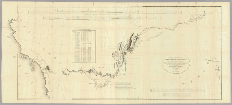
U.S. War Department, Chief of Engineers
Full Title
Map Of California And Nevada, With Parts Of Utah & Arizona. Prepared in the Office of the Chief Of Engineers U.S.A. 1879.
List No
3360.000
Note
A larger version of a portion of the Freyhold/Warren U.S. of 1879. Wheat mentions this map in the same paragraph as the Freyhold/Warren map but he does not notice that they are from the same map! Wheat calls this map "certainly a major map of this large area..." Issued on thin paper for field use. Paper is watermarked "Crane Co. 1885." Map is without color.
Author
Emory, William H.
Full Title
(Title Page to) Notes of a Military Reconnoissance, From Fort Leavenworth, In Missouri, To San Diego, In California, Including Part of the Arkansas, Del Norte, and Gila Rivers. By W.H. Emory, Brevet Major, Corps Topographical Engineers. Made in 1846-7, with the Advanced Guard of the "Army of the West." Washington: Wendell and van Benthuysen, Printers. 1848. [Senate] 30th Congress, 1st Session. Executive, No. 7.
List No
3639A
Author
Emory, William H.
Full Title
Military Reconnaissance Of The Arkansas Rio Del Norte And Rio Gila By W.H. Emory, Lieut. Top. Engrs. Assisted ... by J.W. Abert and W.G. Peck, and ... by W.H. Warner and Mr. Norman Bestor, Made in 1846-7, with the advance guard of the "Army of the West". Under Command Of Brig. Gen. Stephn. W. Kearny. Constructed under the orders of Col. J.J. Abert ... 1847. Drawn by Joseph Welch. Engraved on stone by E. Weber & Co. Baltimore.
List No
3639.001
Note
Senate edition. Has the large map, "Map of a Military Reconnaissance of the Arkansas Rio del Norte and Rio Gila..." See separate listing of the map. Book bound with linen covered boards with title on the spine.
Author
Schonberg & Co.
Full Title
California and the Western Territories.
List No
4324.024
Note
Relief shown in hachures. Prime meridians are Greenwich and Washington D.C. Counties differentiated by full color. A generalized map seriously lacking in detail.
Author
Lloyd, H.H.
Full Title
County map of California and Nevada. County map of Arizona and Southern California. (to accompany) Lloyd's Handy Atlas ... Published By D.L. Guernsey, Concord, N.H. 1874. Entered ... 1872, by H.H. Lloyd, & Co. ... Washington.
List No
4474.025
Note
2 outline hand colored maps. Showing administrative boundaries, numerous cities, railroads, roads, rivers, and mountains. Relief shown by hachures. Prime meridians are Greenwich and Washington.
Author
Cram, George Franklin
Full Title
New Rail Road and County Map of Southern California and Arizona.
List No
4558.058
Author
Johnson, A.J.
Full Title
Johnson's California, Utah, Nevada, Colorado, New Mexico, and Arizona. Published by A. J. Johnson, New York. 79. 80. Entered according to the Act of Congress, in the year 1864, by A.J. Johnson in the Clerk's Office of the District Court of the United States for the Southern District of New York.
List No
4574.040
Note
Engraved color map with counties and districts differentiated by color. Shows roads and railroads. Major relief shown by hachures.
Author
[Bourquin, Frederick, Mitchell, Samuel Augustus, Tanner, Henry S.]
Full Title
Oregon, Upper California & New Mexico. Published by S. Augustus Mitchell, N.E. Corner of Market & 7th. Streets Philadelphia. 1849. Entered according to Act of Congress in the 1845 by H.N. Burroughs - in the Clerk's Office of the Eastern District of Penna. 36.
List No
4578.037
Note
Revision of Mitchell's 1846-1847 maps with title: Oregon and Upper California. Coverage is extended eastward to include New Mexico and part of Missouri Territory. Mexican boundary added. Relief shown by hachures and spot heights. Uncolored. "Oregon" and "Upper or New California" in bold type. Shows Indian tribes and includes descriptive notes. New California extends to the Gulf of California. Prime meridians: Greenwich and Washington. Lithographed. Trails, roads, and rivers shown. Shows the Great Spanish Trail, Oregon Route and Lewis and Clark's Route.
Author
[Bancroft, H.H., Knight, W.H.]
Full Title
(Covers to) Bancroft's Map Of California, Nevada, Utah And Arizona. Published By H.H. Bancroft, & Compy. Booksellers & Stationers San Francisco Cal. 1864. Entered ... 1863 by H.H. Bancroft & Company ... California.
List No
4819.001
Note
First edition, first issue of this map. Entered in 1863 and taken from Bancroft's large Map of the Pacific States of 1864, the second edition (first issued in 1863). All of California and Nevada are shown, along with the western parts of Utah and Arizona. A companion map was issued in the same year covering the northern parts of the Pacific States map: Washington, Oregon, Idaho, and Montana. This is the scarcest of the editions of this map. A second issue was published in the same year, with a different border (interlocking leaves as opposed to interlocking Coltonesque metal strips in this copy), with a clean up of various names that were cut off in this first issue along the northern and eastern borders when the plate was extracted from the large map (for instance, "Painted De" for Painted Desert appears at the 35th parallel on the eastern border of Arizona in the first issue and is removed in the second issue) and different labeling of the railroads (see our 4820). To the right of the title the Colton Company name is embossed: G.W. & C.B. Colton & Co. Publishers Of Maps, Atlases, Etc. 172 William Street. N.Y. Map is full color by county and folded into stamped lavender cloth covers 16x10.5 with "Bancroft's Map Of California, Nevada, Utah And Arizona." in gilt. Prime meridians are Greenwich and Washington D.C. Relief shown by hachures.
Author
[Bancroft, H.H., Knight, W.H.]
Full Title
Bancroft's Map Of California, Nevada, Utah And Arizona. Published By H.H. Bancroft, & Compy. Booksellers & Stationers San Francisco Cal. 1864. Entered ... 1863 by H.H. Bancroft & Company ... California.
List No
4819.002
Note
First edition, first issue of this map. Entered in 1863 and taken from Bancroft's large Map of the Pacific States of 1864, the second edition (first issued in 1863). All of California and Nevada are shown, along with the western parts of Utah and Arizona. A companion map was issued in the same year covering the northern parts of the Pacific States map: Washington, Oregon, Idaho, and Montana. This is the scarcest of the editions of this map. A second issue was published in the same year, with a different border (interlocking leaves as opposed to interlocking Coltonesque metal strips in this copy), with a clean up of various names that were cut off in this first issue along the northern and eastern borders when the plate was extracted from the large map (for instance, "Painted De" for Painted Desert appears at the 35th parallel on the eastern border of Arizona in the first issue and is removed in the second issue) and different labeling of the railroads (see our 4820). To the right of the title the Colton Company name is embossed: G.W. & C.B. Colton & Co. Publishers Of Maps, Atlases, Etc. 172 William Street. N.Y. Map is full color by county and folded into stamped lavender cloth covers 16x10.5 with "Bancroft's Map Of California, Nevada, Utah And Arizona." in gilt. Prime meridians are Greenwich and Washington D.C. Relief shown by hachures.
Author
Bancroft, H.H.
Full Title
(Covers to) Bancroft's Map Of California, Nevada, Utah And Arizona. Published By H.H. Bancroft, & Compy. Booksellers & Stationers San Francisco Cal. 1864. Entered ... 1863, by H.H. Bancroft & Company ... California.
List No
4820A
Author
Bancroft, H.H.
Full Title
Bancroft's Map Of California, Nevada, Utah And Arizona. Published By H.H. Bancroft, & Compy. Booksellers & Stationers San Francisco Cal. 1864. Entered ... 1863, by H.H. Bancroft & Company ... California.
List No
4820.001
Note
First edition, second issue of this map with a different border and small changes in the map (see notes to our #4819). Full color by county. Folded into stamped brown cloth covers 16x10.5 with "Bancroft's Map Of California, Nevada, Utah And Arizona." in gilt.
Author
Colton, G.W.
Full Title
Colton's Map of California, Nevada, Utah, Colorado, Arizona & New Mexico. Published by G.W. & C.B. Colton & Co., No. 172 William St. New York.
List No
4825.060
Note
Shows routes, dates of exploration and the explorers. Prime meridians are Washington D.C. and Greenwich. Relief shown by hachures
Author
Johnson, A.J.
Full Title
Johnson's California, Utah, Nevada, Colorado, New Mexico, and Arizona. Published by Alvin J. Johnson & Co., New York. 79. 80. Entered according to the Act of Congress, in the year 1864, by A.J. Johnson in the Clerk's Office of the District Court of the United States for the Southern District of New York.
List No
4828.055
Note
Engraved color map with counties and districts differentiated by color. Shows roads and railroads. Major relief shown by hachures.
Author
Schonberg & Co.
Full Title
Schonberg's Map of California, Oregon & Nevada with Part of Idaho, Utah & Arizona. Entered ... 1866 .. New York.
List No
5198.004
Note
Counties differentiated by color. Prime meridians Greenwich and Washington D.C. Relief shown by hachures.
Author
[Arrowsmith, Aaron, Humboldt, Alexander von, 1769-1859]
Full Title
(A new map of Mexico and adjacent provinces compiled from original documents by A. Arrowsmith, 1810. Sheet 3). London, Published 5th October 1810 by A. Arrowsmith, 10 Soho Square. (Engraved by E. Jones)
List No
5699.012
Note
Engraved map. Outline hand col. Relief shown by hachures. Sheet 3 of 4. Shows settlements, roads, Indian tribes, rivers, etc. Covers "New Albion" and parts of the Southwest.
Author
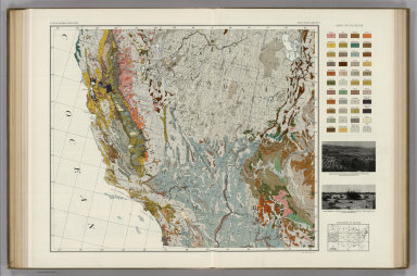
Marbut, Curtis F.
Full Title
Soil Map of the United States by Curtis F. Marbut and Associates in the Soil Survery, U.S. Department of Agriculture, F.J. Marschner, Cartographer and Associate in Compilation. 1931. Soils, Plate 5, Section 5. Lith. A. Hoen & Co., Inc. Atlas of American Agriculture.
List No
5797.091
Note
Includes legend of 12 map sections. Includes soils legend for this section and landscape photographs.
Author
Bancroft, A.L.
Full Title
Bancroft's Map Of California, Nevada, Utah And Arizona. Published By A.L. Bancroft & Compy. Booksellers & Stationers, San Francisco, Cal. 1871. Entered ... by A.L. Bancroft & Company ... Washington, D.C.
List No
5867.000
Note
Compare to the 1873 edition, several differences. Full color by county.
Author
W. & A.K. Johnston Limited
Full Title
California (North), Nevada, Oregon (South). California (South), Nevada (South), Arizona (West).
List No
6921.130
Author
[Fred Harvey, F.G.]
Full Title
(Southwest). (inset) Grand Canyon Natonal Park and Vicinity.
List No
9062.003
1-66 of 66
|