|
Author
Dutton, Clarence E. (Clarence Edward), 1841-1912
Full Title
Geologic Map Of The Colorado Plateau And San Francisco Mountains. Atlas Sheet XXIII. Geology by C.E. Dutton. Julius Bien & Co. lith. U.S. Geological Survey, Geology of the Grand Canon District.
List No
4713.025
Note
In full color. Fourth of four sheets. Map notes that the area "has been well surveyed topographically but has been reconnoitred only by the Geologists. The colors therefore are to be regarded only as an approximation to the distribution of the strata."
Author
Dutton, Clarence E. (Clarence Edward), 1841-1912
Full Title
(Composite) Geologic Map Sheets XX-XXIII. Geology by C.E. Dutton. Julius Bien & Co. lith. U.S. Geological Survey, Geology of the Grand Canon District.
List No
4713.026
Note
Composite map consists of four sheets although it was originally intended to have six. A note in the index states that "although much material has been obtained for their construction, much more is still required. No attempt to supply the defect has, therefore, been made in the present work." In full color.
Author
Cram, George Franklin
Full Title
Railroad and County Map of Arizona. Geo. F. Cram. Engraver and Publisher, Chicago.
List No
4727.047
Note
Prime meridians Washington D.C. and Greenwich. Relief shown by hachures. With printed color.
Author
Gray, Ormando Willis
Full Title
Gray's Atlas Map of New Mexico and Arizona.
List No
4740.055
Note
Prime meridians Washington D.C. and Greenwich. Relief shown by hachures.
Author
[Bancroft, H.H., Knight, W.H.]
Full Title
(Covers to) Bancroft's Map Of California, Nevada, Utah And Arizona. Published By H.H. Bancroft, & Compy. Booksellers & Stationers San Francisco Cal. 1864. Entered ... 1863 by H.H. Bancroft & Company ... California.
List No
4819.001
Note
First edition, first issue of this map. Entered in 1863 and taken from Bancroft's large Map of the Pacific States of 1864, the second edition (first issued in 1863). All of California and Nevada are shown, along with the western parts of Utah and Arizona. A companion map was issued in the same year covering the northern parts of the Pacific States map: Washington, Oregon, Idaho, and Montana. This is the scarcest of the editions of this map. A second issue was published in the same year, with a different border (interlocking leaves as opposed to interlocking Coltonesque metal strips in this copy), with a clean up of various names that were cut off in this first issue along the northern and eastern borders when the plate was extracted from the large map (for instance, "Painted De" for Painted Desert appears at the 35th parallel on the eastern border of Arizona in the first issue and is removed in the second issue) and different labeling of the railroads (see our 4820). To the right of the title the Colton Company name is embossed: G.W. & C.B. Colton & Co. Publishers Of Maps, Atlases, Etc. 172 William Street. N.Y. Map is full color by county and folded into stamped lavender cloth covers 16x10.5 with "Bancroft's Map Of California, Nevada, Utah And Arizona." in gilt. Prime meridians are Greenwich and Washington D.C. Relief shown by hachures.
Author
[Bancroft, H.H., Knight, W.H.]
Full Title
Bancroft's Map Of California, Nevada, Utah And Arizona. Published By H.H. Bancroft, & Compy. Booksellers & Stationers San Francisco Cal. 1864. Entered ... 1863 by H.H. Bancroft & Company ... California.
List No
4819.002
Note
First edition, first issue of this map. Entered in 1863 and taken from Bancroft's large Map of the Pacific States of 1864, the second edition (first issued in 1863). All of California and Nevada are shown, along with the western parts of Utah and Arizona. A companion map was issued in the same year covering the northern parts of the Pacific States map: Washington, Oregon, Idaho, and Montana. This is the scarcest of the editions of this map. A second issue was published in the same year, with a different border (interlocking leaves as opposed to interlocking Coltonesque metal strips in this copy), with a clean up of various names that were cut off in this first issue along the northern and eastern borders when the plate was extracted from the large map (for instance, "Painted De" for Painted Desert appears at the 35th parallel on the eastern border of Arizona in the first issue and is removed in the second issue) and different labeling of the railroads (see our 4820). To the right of the title the Colton Company name is embossed: G.W. & C.B. Colton & Co. Publishers Of Maps, Atlases, Etc. 172 William Street. N.Y. Map is full color by county and folded into stamped lavender cloth covers 16x10.5 with "Bancroft's Map Of California, Nevada, Utah And Arizona." in gilt. Prime meridians are Greenwich and Washington D.C. Relief shown by hachures.
Author
Bancroft, H.H.
Full Title
(Covers to) Bancroft's Map Of California, Nevada, Utah And Arizona. Published By H.H. Bancroft, & Compy. Booksellers & Stationers San Francisco Cal. 1864. Entered ... 1863, by H.H. Bancroft & Company ... California.
List No
4820A
Author
Bancroft, H.H.
Full Title
Bancroft's Map Of California, Nevada, Utah And Arizona. Published By H.H. Bancroft, & Compy. Booksellers & Stationers San Francisco Cal. 1864. Entered ... 1863, by H.H. Bancroft & Company ... California.
List No
4820.001
Note
First edition, second issue of this map with a different border and small changes in the map (see notes to our #4819). Full color by county. Folded into stamped brown cloth covers 16x10.5 with "Bancroft's Map Of California, Nevada, Utah And Arizona." in gilt.
Author
Colton, G.W.
Full Title
Colton's Map of California, Nevada, Utah, Colorado, Arizona & New Mexico. Published by G.W. & C.B. Colton & Co., No. 172 William St. New York.
List No
4825.060
Note
Shows routes, dates of exploration and the explorers. Prime meridians are Washington D.C. and Greenwich. Relief shown by hachures
Author
Johnson, A.J.
Full Title
Johnson's California, Utah, Nevada, Colorado, New Mexico, and Arizona. Published by Alvin J. Johnson & Co., New York. 79. 80. Entered according to the Act of Congress, in the year 1864, by A.J. Johnson in the Clerk's Office of the District Court of the United States for the Southern District of New York.
List No
4828.055
Note
Engraved color map with counties and districts differentiated by color. Shows roads and railroads. Major relief shown by hachures.
Author
Rand McNally and Company
Full Title
(Covers to) Rand, McNally & Co.'s Arizona. (on verso of title page) Entered ... 1879, by Rand, McNally & Co. ... Washington.
List No
4887A
Note
Green card board covers with "Rand, McNally & Co's Indexed Map of Arizona ... Chicago: Rand, McNally & Co., Printers and Engravers, 77 and 79 Madison Street." printed in black. Printed outline color by county.
Author
Rand McNally and Company
Full Title
(Title Page to) Rand, McNally & Co.'s Arizona. (on verso of title page) Entered ... 1879, by Rand, McNally & Co. ... Washington.
List No
4887B
Note
Title page with "New publications of Rand, McNally & Co." (inside cover)
Author
Rand McNally and Company
Full Title
(Index to and title page verso) Rand, McNally & Co.'s Arizona. (on verso of title page) Entered ... 1879, by Rand, McNally & Co. ... Washington.
List No
4887C
Note
Verso of title page and first page of index.
Author
Rand McNally and Company
Full Title
(Index to) Rand, McNally & Co.'s Arizona. (on verso of title page) Entered ... 1879, by Rand, McNally & Co. ... Washington.
List No
4887D
Note
Index (p. 2-3)
Author
Rand McNally and Company
Full Title
(Index to and advertisement) Rand, McNally & Co.'s Arizona. (on verso of title page) Entered ... 1879, by Rand, McNally & Co. ... Washington.
List No
4887E
Note
Index (p. 6) and facing advertisement "The Rand-McNally official railway guide ..."
Author
Rand McNally and Company
Full Title
Rand, McNally & Co.'s Arizona. (Entered ... 1879, by Rand, McNally & Co. ... Washington)
List No
4887.001
Note
With index. Map is folded into green card board covers 15.5x9 with "Rand, McNally & Co's Indexed Map of Arizona ... Chicago: Rand, McNally & Co., Printers and Engravers, 77 and 79 Madison Street." printed in black. Printed outline color by county. Relief shown by hachures. Shows roads, trails, railroads, Indian reservations, etc. David Rumsey Collection copy has additions in red and green pencil.
Author
Asher & Adams
Full Title
Asher & Adams' Arizona. Entered according to Act of Congress 1874 by Asher & Adams in the Office of the Librarian of Congress at Washington.
List No
4977.078
Note
Washington Meridian. Hand tinted full color. Shows railroads, settlements, counties, waterways, and lakes. Shows "supposed course of the Santa Cruz river, which sinks at Tuscon" and which daylights near Maricopa Wells. Labeled peaks shown by hachures. Engraved.
Author
Rand McNally and Company
Full Title
(Text Page) Common Names for Railroads and Rail Systems. Miles of Railroads in Operation in the United States, 1830-1922. Miles of Railroads in Operation in Each State, January 1923. Industrial Statistics of the United States. Alabama. Arizona.
List No
5028V
Note
Industrial statistics by state and county including county seat, area, and statistics on population, agriculture and manufacturing. Includes descriptions of mines, quarries, and wells.
Author
Rand McNally and Company
Full Title
Commercial Atlas of America. Rand McNally AutoTrails Map, District Number 17, (Utah, Colorado, New Mexico, Arizona)
List No
5028.127
Note
Shows roads and distances. Shows table of highway names, numbers, and markings. Relief shown by hachures.
Author
Rand McNally and Company
Full Title
Commercial Atlas of America. Rand McNally Black and White Mileage Map, Arizona and New Mexico.
List No
5028.128
Note
Shows railroads and distances.
Author
Rand McNally and Company
Full Title
(Text Page) Arizona - Counties, Indian Reservations, Lakes, Mountains, Rivers, Towns, Etc.
List No
5028DY
Note
Geographical features keyed to map; populations of towns. Shows electric lines.
Author
Rand McNally and Company
Full Title
Commercial Atlas of America. Rand McNally Standard Map of Arizona.
List No
5028.129
Note
Shows railroads and distances. Includes tables of principal cities and railroads, keyed to map. Relief shown by hachures.
Author
Rand McNally and Company
Full Title
(Text Page) Arizona - Counties, Indian Reservations, Lakes, Mountains, Rivers, Towns, Etc. Colorado - Counties, Creeks, Lakes, Mountains, Peaks, Rivers, and Towns.
List No
5028DZ
Note
Geographical features keyed to map; populations of towns. Shows electric lines.
Author
Mitchell, Samuel Augustus Jr.
Full Title
County Map of Arizona and New Mexico. Entered ... 1874 by S. Augustus Mitchell ... Washington.
List No
5041.040
Note
Relief shown in hachures. Prime meridians are Washington D.C. and Greenwich.
Author
Schonberg & Co.
Full Title
Schonberg's Map of California, Oregon & Nevada with Part of Idaho, Utah & Arizona. Entered ... 1866 .. New York.
List No
5198.004
Note
Counties differentiated by color. Prime meridians Greenwich and Washington D.C. Relief shown by hachures.
Author
Cram, George Franklin
Full Title
Cram's Rail Road & Township Map of Arizona. Published by Geo. F. Cram. Proprietor of the Western Map Depot. 66, Lake St. Chicago Ills. 1875.
List No
5370.027
Note
Map in full color by county.
Author
Colton, G.W.
Full Title
Territories of New Mexico and Utah (and Nevada and Arizona). No. 51. Published by J.H. Colton & Co., No 172 William St., New York. Entered according to the Act of Congress in the year 1855 by J.H. Colton & Co. in the Clerk's Office of the District Court of the United States for the Southern District of New York.
List No
5479.099
Note
Meridians Washington and Greenwich. Counties tinted in color. Relief shown with hachures. Shows settlements and routes of exploration including proposed railroad routes.
Author
Rand McNally and Company
Full Title
(Covers to) Rand McNally Official 1925 Auto Trails Map Arizona New Mexico. Copyright by Rand McNally & Company Chicago, Ill. Made in U.S.A.
List No
5566.001
Note
Maps in outline color with copious information about road conditions, trail, and highway markings. Bound into cardboard covers 19x10.5 cm. with "Rand McNally official Auto Trails Map, Arizona, New Mexico. 35¢. Rand McNally & Company. Chicago - New York." on the cover. Includes a booklet.
Author
Rand McNally and Company
Full Title
(Title page to) Rand McNally Official 1925 Auto Trails Map Arizona New Mexico. Copyright by Rand McNally & Company Chicago, Ill. Made in U.S.A.
List No
5566.002
Note
Maps in outline color with copious information about road conditions, trail, and highway markings. Bound into cardboard covers 19x10.5 cm. with "Rand McNally official Auto Trails Map, Arizona, New Mexico. 35¢. Rand McNally & Company. Chicago - New York." on the cover. Includes a booklet.
Author
Rand McNally and Company
Full Title
Rand McNally Official 1925 Auto Trails Map Arizona New Mexico. Copyright by Rand McNally & Company Chicago, Ill. Made in U.S.A.
List No
5566.003
Note
Maps in outline color with copious information about road conditions, trail, and highway markings. Bound into cardboard covers 19x10.5 cm. with "Rand McNally official Auto Trails Map, Arizona, New Mexico. 35¢. Rand McNally & Company. Chicago - New York." on the cover. Includes a booklet.
Author
[Arrowsmith, Aaron, Humboldt, Alexander von, 1769-1859]
Full Title
(A new map of Mexico and adjacent provinces compiled from original documents by A. Arrowsmith, 1810. Sheet 3). London, Published 5th October 1810 by A. Arrowsmith, 10 Soho Square. (Engraved by E. Jones)
List No
5699.012
Note
Engraved map. Outline hand col. Relief shown by hachures. Sheet 3 of 4. Shows settlements, roads, Indian tribes, rivers, etc. Covers "New Albion" and parts of the Southwest.
Author
Rand McNally and Company
Full Title
Rand McNally junior auto road map Arizona, New Mexico. Copyright by Rand McNally & Co., Chicago, Ill. (1927)
List No
5755.032
Note
Color map. Relief shown by hachures. Shows settlements, classified roads with distances, etc. "I-40."
Full Title
County and township map of Arizona and New Mexico. Copyright 1886 by Wm. M. Bradley & Bro.
List No
5784.046
Note
Hand colored. Relief shown by hachures. Shows Indian reservations, military reservations, inhabited places, railroads, drainage, etc. Prime meridians: Greenwich and Washington.
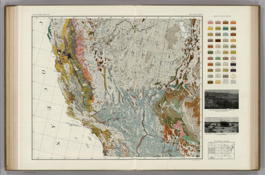
Author
Marbut, Curtis F.
Full Title
Soil Map of the United States by Curtis F. Marbut and Associates in the Soil Survery, U.S. Department of Agriculture, F.J. Marschner, Cartographer and Associate in Compilation. 1931. Soils, Plate 5, Section 5. Lith. A. Hoen & Co., Inc. Atlas of American Agriculture.
List No
5797.091
Note
Includes legend of 12 map sections. Includes soils legend for this section and landscape photographs.
Author
Marbut, Curtis F.
Full Title
Soil Map of the United States by Curtis F. Marbut and Associates in the Soil Survery, U.S. Department of Agriculture, F.J. Marschner, Cartographer and Associate in Compilation. 1931. Soils, Plate 5, Section 6. Lith. A. Hoen & Co., Inc. Atlas of American Agriculture.
List No
5797.092
Note
Includes legend of 12 map sections. Includes soils legend for this section and landscape photographs.
Author
Marbut, Curtis F.
Full Title
Soil Map of the United States by Curtis F. Marbut and Associates in the Soil Survery, U.S. Department of Agriculture, F.J. Marschner, Cartographer and Associate in Compilation. 1931. Soils, Plate 5, Section 11. Lith. A. Hoen & Co., Inc. Atlas of American Agriculture.
List No
5797.112
Note
Includes legend of 12 map sections. Includes soils legend for this section and landscape photographs.
Author
[Marschner, Francis J., Marbut, Curtis F.]
Full Title
Soil Map of the United States by Curtis F. Marbut and Associates in the Soil Survery, U.S. Department of Agriculture, F.J. Marschner, Cartographer and Associate in Compilation. 1931. Soils, Plate 5, Section 12. Lith. A. Hoen & Co., Inc. Atlas of American Agriculture.
List No
5797.113
Note
Includes legend of 12 map sections. Includes soils legend for entire map and landscape photographs.
Author
[Marschner, Francis J., Marbut, Curtis F.]
Full Title
(Composite of) Soil Map of the United States by Curtis F. Marbut and Associates in the Soil Survery, U.S. Department of Agriculture, F.J. Marschner, Cartographer and Associate in Compilation. 1931. Soils, Plate 5, (Sections 1-12). Lith. A. Hoen & Co., Inc. Atlas of American Agriculture.
List No
5797.114
Note
Includes legend of 12 map sections. Includes soils legend for entire map and landscape photographs.
Author
Shell Oil Company
Full Title
Shell Map of Arizona (cover title). Shell Highway Map of Arizona. 6-DD-1956-1. (insets) Phoenix; Tuscon.
List No
5840.011
Author
Shell Oil Company
Full Title
Grand Canyon National Park. Zion National Park. Wapatki and Sunset Crater. Petrified Forest National Monument. Chiricahua National Monument. United States Mileage and Driving Time. (Verso to) Shell Highway Map of Arizona.
List No
5840.012
Author
Shell Oil Company
Full Title
Shell Map of Arizona, New Mexico (cover title). Shell Highway Map of Arizona and New Mexico. 7-Y-1951-2.
List No
5840.013
Author
Shell Oil Company
Full Title
Santa Fe and Vicinity. Lincoln National Forest Region. Santa Fe. Tucson. Phoenix. Albuquerque. Grand Canyon National Park. Carlsbad Caverns National Park. Petrified Forest National Monument. (Verso to) Shell Highway Map of Arizona and New Mexico.
List No
5840.014
Author
[Bayer, Herbert, Container Corporation of America]
Full Title
New Mexico. U.S. State. Arizona.
List No
5842.080
Note
Map and graphics showing principal resources, population, occupations, manufacturing, mineral production, agriculture, and land use. Includes brief history and description of states' features. Relief depicted by hachures.
Author
[Bayer, Herbert, Container Corporation of America]
Full Title
Arizona. U.S. State. Utah. U.S. State.
List No
5842.081
Note
Map and graphics showing principal resources, population, occupations, manufacturing, mineral production, agriculture, and land use. Includes brief history and description of states' features. Relief depicted by hachures.
Author
Bancroft, A.L.
Full Title
Bancroft's Map Of California, Nevada, Utah And Arizona. Published By A.L. Bancroft & Compy. Booksellers & Stationers, San Francisco, Cal. 1871. Entered ... by A.L. Bancroft & Company ... Washington, D.C.
List No
5867.000
Note
Compare to the 1873 edition, several differences. Full color by county.
Author
[State Farm Insurance Companies Travel Bureau, Rand McNally and Company]
Full Title
Rand McNally Road map, Arizona, New Mexico. Copyright by Rand McNally & Company, Chicago, Ill. Lithographed in the U.S.A. (to accompany) State Farm Road Atlas: United States, Canada, Mexico,Central and South America. Copyright 1940 by Rand McNally & Company, Chicago, Ill.
List No
5969.020
Note
Color map. U.S. interstate highways shown in red. Shows roads, capitals, population of cities and towns, Indian reservations, etc.Relief shown by hachures and spot heights. On the lower corner: v.3627. On the upper corner: Ariz., N. Mex.
Author
Manning, Reginald W. (1905-1989)
Full Title
Reg Mannning's Cartoon Map of Arizona.
List No
6058.000
Note
Pictorial. Cute map printed in brown.
Author
[U.S. Geological Survey, Alpha, Tau Rho]
Full Title
Upper Verde River, Arizona.
List No
6353.124
Author
[Rand McNally and Company, State Farm Insurance Companies Travel Bureau]
Full Title
Rand McNally Road map: Arizona, New Mexico. Copyright by Rand McNally & Company, Chicago, Ill. Lithorgaphed in the U.S.A. U.3627. (to accompany) State Farm road atlas : United States, Canada, Mexico.
List No
6825.017
Note
Color map. U.S. interstate highways shown in red. Shows time zone boundaries, roads, ferries, highways, rivers and streams. Includes population of cities and towns. Relief shown by hachures.
Author
W. & A.K. Johnston Limited
Full Title
New Mexico, Arizona. Washington, Oregon, Idaho.
List No
6921.129
|