|
Author
U.S. General Land Office
Full Title
Territory of Arizona. 1905. Compiled from the Official Records of the General Land Office and other Sources under Supervision of Harry King, G.E. Chief of Drafting Division, G.L.O. ; Revised and Reconstructed by R.H. Morton. (Sequence of ten maps of the Territory of Arizona, 1896, 1901, 1902, 1903, 1905, 1906, 1907, 1908, 1909, 1910 from the Annual Reports of the Governor of Arizona. With: Report of the Governor of Arizona for each of those years, plus the years 1897 and 1904, for which no maps were issued.)
List No
3773.005
Note
Ten maps each 52x43 cm., printed with outline and full color. Not in Kelsay, these maps record the development of the territory over a fourteen year period. These are smaller than the usual GLO maps and may have been made specially for the Territorial Annual Reports. Shows private claims confirmed and unconfirmed, Indian, military, and forest reservations. Relief shown by shading. Prime meridians are Greenwich and Washington D.C.
Author
U.S. General Land Office
Full Title
Territory of Arizona. 1906. Compiled from the Official Records of the General Land Office and other Sources under Supervision of Harry King, G.E. Chief of Drafting Division, G.L.O. ; Revised and Reconstructed by R.H. Morton. (Sequence of ten maps of the Territory of Arizona, 1896, 1901, 1902, 1903, 1905, 1906, 1907, 1908, 1909, 1910 from the Annual Reports of the Governor of Arizona. With: Report of the Governor of Arizona for each of those years, plus the years 1897 and 1904, for which no maps were issued.)
List No
3773.006
Note
Ten maps each 52x43 cm., printed with outline and full color. Not in Kelsay, these maps record the development of the territory over a fourteen year period. These are smaller than the usual GLO maps and may have been made specially for the Territorial Annual Reports. Shows private claims confirmed and unconfirmed, Indian, military, and forest reservations. Relief shown by shading. Prime meridians are Greenwich and Washington D.C.
Author
U.S. General Land Office
Full Title
Territory of Arizona. 1907. Compiled from the Official Records of the General Land Office and other Sources under Supervision of Harry King, G.E. Chief of Drafting Division, G.L.O. ; Revised and Reconstructed by R.H. Morton. (Sequence of ten maps of the Territory of Arizona, 1896, 1901, 1902, 1903, 1905, 1906, 1907, 1908, 1909, 1910 from the Annual Reports of the Governor of Arizona. With: Report of the Governor of Arizona for each of those years, plus the years 1897 and 1904, for which no maps were issued.)
List No
3773.007
Note
Ten maps each 52x43 cm., printed with outline and full color. Not in Kelsay, these maps record the development of the territory over a fourteen year period. These are smaller than the usual GLO maps and may have been made specially for the Territorial Annual Reports. Shows private claims confirmed and unconfirmed, Indian, military, and forest reservations. Relief shown by shading. Prime meridians are Greenwich and Washington D.C.
Author
U.S. General Land Office
Full Title
Territory of Arizona. 1908. Compiled from the Official Records of the General Land Office and other Sources under Supervision of Harry King, G.E. Chief of Drafting Division, G.L.O. ; Revised and Reconstructed by R.H. Morton. (Sequence of ten maps of the Territory of Arizona, 1896, 1901, 1902, 1903, 1905, 1906, 1907, 1908, 1909, 1910 from the Annual Reports of the Governor of Arizona. With: Report of the Governor of Arizona for each of those years, plus the years 1897 and 1904, for which no maps were issued.)
List No
3773.008
Note
Ten maps each 52x43 cm., printed with outline and full color. Not in Kelsay, these maps record the development of the territory over a fourteen year period. These are smaller than the usual GLO maps and may have been made specially for the Territorial Annual Reports. Shows private claims confirmed and unconfirmed, Indian, military, and forest reservations. Relief shown by shading. Prime meridians are Greenwich and Washington D.C.
Author
U.S. General Land Office
Full Title
Territory of Arizona. 1909. Compiled from the Official Records of the General Land Office and other Sources under Supervision of Harry King, G.E. Chief of Drafting Division, G.L.O. ; Revised and Reconstructed by R.H. Morton. (Sequence of ten maps of the Territory of Arizona, 1896, 1901, 1902, 1903, 1905, 1906, 1907, 1908, 1909, 1910 from the Annual Reports of the Governor of Arizona. With: Report of the Governor of Arizona for each of those years, plus the years 1897 and 1904, for which no maps were issued.)
List No
3773.009
Note
Ten maps each 52x43 cm., printed with outline and full color. Not in Kelsay, these maps record the development of the territory over a fourteen year period. These are smaller than the usual GLO maps and may have been made specially for the Territorial Annual Reports. Shows private claims confirmed and unconfirmed, Indian, military, and forest reservations. Relief shown by shading. Prime meridians are Greenwich and Washington D.C.
Author
U.S. General Land Office
Full Title
Territory of Arizona. 1910. Compiled from the Official Records of the General Land Office and other Sources under Supervision of Harry King, G.E. Chief of Drafting Division, G.L.O. ; Revised and Reconstructed by R.H. Morton. (Sequence of ten maps of the Territory of Arizona, 1896, 1901, 1902, 1903, 1905, 1906, 1907, 1908, 1909, 1910 from the Annual Reports of the Governor of Arizona. With: Report of the Governor of Arizona for each of those years, plus the years 1897 and 1904, for which no maps were issued.)
List No
3773.010
Note
Ten maps each 52x43 cm., printed with outline and full color. Not in Kelsay, these maps record the development of the territory over a fourteen year period. These are smaller than the usual GLO maps and may have been made specially for the Territorial Annual Reports. Shows private claims confirmed and unconfirmed, Indian, military, and forest reservations. Relief shown by shading. Prime meridians are Greenwich and Washington D.C.
Author
U.S. General Land Office
Full Title
Department Of The Interior General Land Office Hon. Wm. A.J. Sparks, Commissioner. Territory Of Arizona. 1887. Compiled from the official Records of the General Land Office and other sources, under supervision of Geo. U. Mayo, Civil Engineer - Chief or Drafting Division, G.L.O. 1894. Photo lith & print by Julius Bien & Co. 139 Duane St. N.Y. Compiled And drawn by A.F. Dinsmore.
List No
3799.000
Note
Printed in color. Far more detailed than the 1883 edition. Probably the most detailed and accurate map of the Territory to date. Scale: 12 miles to 1 inch. Shows private land grants confirmed and unconfirmed, Surveyor General's Office and Land Offices in color, townships, completed railroads, Indian reservations, military reservations, and county boundaries. Relief shown by hachures. Prime meridians are Greenwich and Washington, D.C.
Author
Colton, G.W.
Full Title
Colton's New Mexico and Arizona.
List No
3800.121
Author
Mitchell, Samuel Augustus Jr.
Full Title
County map of Arizona and New Mexico. Entered ... 1874, by S. Augustus Mitchell ... Washington.
List No
3804.045
Note
Hand colored map by county. Shows settlements, Indian tribes and vilages, roads, railroads, etc. Relief shown by hachures. Prime meridians are Greenwich and Washington.
Author
Gray, Ormando Willis
Full Title
New Mexico and Arizona.
List No
3888.051
Note
Prime meridians Washington D.C. and Greenwich. Relief shown by hachures. Full color.
Author
National Map Company
Full Title
Arizona and New Mexico. (Copyrighted by) National Map Company, Indianapolis. (to accompany) Official Paved Road and Commercial Survey of the United States.
List No
4048.056
Note
Outline color map. Shows administrative divisions, roads, rivers, etc. Relief shown by hachures. Prime meridian is Greenwich.
Author
Gird, Richard
Full Title
(Covers to) Official Map Of The Territory Of Arizona, With All The Recent Explorations. Compiled by Richard Gird C.E. Commissioner. Approved By John N. Goodwin, Governor. In Accordance With An Act Of The Legislature, Approved Oct. 23d. 1864. We hereby certify that this is the Official Map of the Territory of Arizona, and approve the same. Prescott October 12th 1865. (with signed seal dated 1863). Published By A. Gensoul, Pacific Map Depot. No. 511 Montgomery St. San Francisco. Lith. Britton & Co. San Francisco.
List No
4217A
Author
Gird, Richard
Full Title
Official Map Of The Territory Of Arizona, With All The Recent Explorations. Compiled by Richard Gird C.E. Commissioner. Approved By John N. Goodwin, Governor. In Accordance With An Act Of The Legislature, Approved Oct. 23d. 1864. We hereby certify that this is the Official Map of the Territory of Arizona, and approve the same. Prescott October 12th 1865. (with signed seal dated 1863). Published By A. Gensoul, Pacific Map Depot. No. 511 Montgomery St. San Francisco. Lith. Britton & Co. San Francisco.
List No
4217.001
Note
Wheat: "In Arizona the year 1865 was made notable by the first great map of that Territory, the 'Official Map of the Territory of Arizona...by Richard Gird'...Gird's richly varied map concentrates upon Arizona and adjacent parts of California and Sonora..." Wheat also reprints a portion of Bancroft's description of Gird's life. Streeter lists the Hartley Map of Arizona as circa 1863 and hence earlier that the Gird; Wheat disagrees, listing Hartley as 1865 (as, he claims, the Library of Congress does also), thus making the Gird the more important map: "Except that it is overshadowed by Gird's great map, Hartley's production would receive more attention here." Gird's map is full of interesting detail and is also a beautiful graphic production. Full color by county. Folded into blue patterned cloth covers 16x11 with "Gird's Official Map Of The Territory Of Arizona. A. Gensoul, Publisher." printed in gold on a black paste down label.
Author
State Farm Insurance Companies Travel Bureau
Full Title
State Farm Road map: Arizona, New Mexico. Copyright by Rand McNally & Company, Chicago, Ill. Lithographed in U.S.A. Z.3627. (on upper corners) Ariz. N. Mex.
List No
4246.013
Note
Color map. Shows roads, points of interest, distances, time zone boundaries, populations, etc. U.S. interstate and principal state highways shown in red. Relief shown by hachures.
Author
Schonberg & Co.
Full Title
California and the Western Territories.
List No
4324.024
Note
Relief shown in hachures. Prime meridians are Greenwich and Washington D.C. Counties differentiated by full color. A generalized map seriously lacking in detail.
Author
Clason Map Company
Full Title
Clason's Road Map of Arizona and New Mexico. Showing paved roads, All weather roads and other throughfares. (U.S. Highways shown in red.) Published by the Clason Map Co., Chicago-Denver. Copyrighted Clason Map. All rights reserved. Map No. R-208A.
List No
4423.044
Note
Color map. Includes road legend, and Index of cities and towns giving populations and Key to map.
Author
Lloyd, H.H.
Full Title
County map of California and Nevada. County map of Arizona and Southern California. (to accompany) Lloyd's Handy Atlas ... Published By D.L. Guernsey, Concord, N.H. 1874. Entered ... 1872, by H.H. Lloyd, & Co. ... Washington.
List No
4474.025
Note
2 outline hand colored maps. Showing administrative boundaries, numerous cities, railroads, roads, rivers, and mountains. Relief shown by hachures. Prime meridians are Greenwich and Washington.
Author
Rand McNally and Company
Full Title
Rand, McNally & Co.'s Arizona.
List No
4520.050
Note
Counties in outline color. Relief shown by hachures. Prime meridians: Greenwich and Washington.
Author
Cram, George Franklin
Full Title
Cram's Rail Road & Township Map of Arizona.
List No
4533.033
Author
Cram, George Franklin
Full Title
New Rail Road and County Map of Southern California and Arizona.
List No
4558.058
Author
Mitchell, Samuel Augustus Jr.
Full Title
County map of Arizona and New Mexico. Entered ... 1877 by S. Augustus Mitchell, . ... Washington.
List No
4564.046
Note
Full color map by county. Shows railroad, river, fort, Indian settlements, exploration routes and explorers, etc. Relief shown by hachures and spot heights.
Author
Johnson, A.J.
Full Title
Johnson's California, Utah, Nevada, Colorado, New Mexico, and Arizona. Published by A. J. Johnson, New York. 79. 80. Entered according to the Act of Congress, in the year 1864, by A.J. Johnson in the Clerk's Office of the District Court of the United States for the Southern District of New York.
List No
4574.040
Note
Engraved color map with counties and districts differentiated by color. Shows roads and railroads. Major relief shown by hachures.
Author
[Bourquin, Frederick, Mitchell, Samuel Augustus, Tanner, Henry S.]
Full Title
Oregon, Upper California & New Mexico. Published by S. Augustus Mitchell, N.E. Corner of Market & 7th. Streets Philadelphia. 1849. Entered according to Act of Congress in the 1845 by H.N. Burroughs - in the Clerk's Office of the Eastern District of Penna. 36.
List No
4578.037
Note
Revision of Mitchell's 1846-1847 maps with title: Oregon and Upper California. Coverage is extended eastward to include New Mexico and part of Missouri Territory. Mexican boundary added. Relief shown by hachures and spot heights. Uncolored. "Oregon" and "Upper or New California" in bold type. Shows Indian tribes and includes descriptive notes. New California extends to the Gulf of California. Prime meridians: Greenwich and Washington. Lithographed. Trails, roads, and rivers shown. Shows the Great Spanish Trail, Oregon Route and Lewis and Clark's Route.
Author
Colton, G.W.
Full Title
Colton's New Mexico and Arizona. Published By G. W & C. B. Colton & Co., No. 172 William St. New York.
List No
4587.066
Note
Prime meridians are Washington D.C. and Greenwich.
Author
U.S. General Land Office
Full Title
Department Of The Interior General Land Office J.A. Williamson, Commissioner. Territory Of Arizona. 1879. Compiled from the official Records of the General Land Office and other sources by C. Roeser, Principal Draughtsman G.L.O. Photo lith & print by Julius Bien 16 & 18 Park Place N.Y.
List No
4646.000
Note
Good detail on the Grand Canyon. With printed full and outline color.
Author
Dutton, Clarence E. (Clarence Edward), 1841-1912
Full Title
(Covers to) Department Of The Interior, United States Geological Survey, J.W. Powell Director. Atlas To Accompany The Monograph On The Tertiary History Of The Grand Canon District By Capt. Clarence E. Dutton U.S.A. Washington 1882. Julius Bien & Co. Lith. New York.
List No
4713A
Author
Dutton, Clarence E. (Clarence Edward), 1841-1912
Full Title
(Title Page to) Department Of The Interior, United States Geological Survey, J.W. Powell Director. Atlas To Accompany The Monograph On The Tertiary History Of The Grand Canon District By Capt. Clarence E. Dutton U.S.A. Washington 1882. Julius Bien & Co. Lith. New York.
List No
4713B
Note
With superb panoramas by W.H. Holmes and Thomas Moran. This is one of the finest publications of U.S. Geological Survey. Full printed color. Bound in dark brown cloth covered boards with "United States Geological Survey J.W. Powell Director. Atlas To Accompany The Teriary History Of The Grand Canon District. Dutton" stamped in gilt.
Author
Dutton, Clarence E. (Clarence Edward), 1841-1912
Full Title
(Index to) Department Of The Interior, United States Geological Survey, J.W. Powell Director. Atlas To Accompany The Monograph On The Tertiary History Of The Grand Canon District By Capt. Clarence E. Dutton U.S.A. Washington 1882. Julius Bien & Co. Lith. New York.
List No
4713C
Author
Dutton, Clarence E. (Clarence Edward), 1841-1912
Full Title
Geological Map Of The Western Part Of The Plauteau Province. Sheet II. J.H. Renshawe, Del. Geology by C.E. Dutton, Geologist-in-Charge. Julius Bien, lith. N.Y. U.S. Geological Survey, Geology of the Grand Canon District.
List No
4713.001
Note
In full color with a guide below the map.
Author
Dutton, Clarence E. (Clarence Edward), 1841-1912
Full Title
Sketch Map of the Western Part of the Plateau Province showing The Faults of the Grand Canon District and High Plateaus. Sheet III. Julius Bien, lith. N.Y. C.E. Dutton, Geologist-in-Charge. U.S. Geological Survey, Geology of the Grand Canon District.
List No
4713.002
Note
Map without color.
Author
[Dutton, Clarence E. (Clarence Edward), 1841-1912, Holmes, William Henry, 1846-1933]
Full Title
Looking up the Toroweap from Vulcan's Throne. W(illiam) H. H(olmes). Atlas Sheet V. Julius Bien & Co. lith. U.S. Geological Survey, Geology of the Grand Canon District.
List No
4713.004
Note
In full color. Two views are included on this Atlas Sheet. It is noted below that the two views are continuous. They show the lava streams and flows descending from the Craters and the Plateau.
Author
[Dutton, Clarence E. (Clarence Edward), 1841-1912, Holmes, William Henry, 1846-1933]
Full Title
The Grand Canon at the foot of the Toroweap - Looking East. W(illiam) H. H(olmes). Atlas Sheet VI. Julius Bien & Co. lith. U.S. Geological Survey, Geology of the Grand Canon District.
List No
4713.005
Note
In full color.
Author
Dutton, Clarence E. (Clarence Edward), 1841-1912
Full Title
Map Of The Uinkaret Plateau. North Half. Atlas Sheet VII. Geology by C.E. Dutton. Julius Bien & Co. lith. U.S. Geological Survey, Geology of the Grand Canon District.
List No
4713.006
Note
In full color.
Author
Dutton, Clarence E. (Clarence Edward), 1841-1912
Full Title
Map Of The Uinkaret Plateau. South Half. Atlas Sheet VIII. Geology by C.E. Dutton. Julius Bien & Co. lith. U.S. Geological Survey, Geology of the Grand Canon District.
List No
4713.007
Note
In full color.
Author
Dutton, Clarence E. (Clarence Edward), 1841-1912
Full Title
(Composite) Map Of The Uinkaret Plateau. North and South Half. Atlas Sheets VII and VIII. Geology by C.E. Dutton. Julius Bien & Co. lith. U.S. Geological Survey, Geology of the Grand Canon District.
List No
4713.008
Note
In full color. Composite map of sheets VII and VIII.
Author
[Dutton, Clarence E. (Clarence Edward), 1841-1912, Holmes, William Henry, 1846-1933]
Full Title
Views looking east and south from Mt. Trumbull. W(illiam) H. H(olmes). Atlas Sheet IX. Julius Bien & Co. lith. U.S. Geological Survey, Geology of the Grand Canon District.
List No
4713.009
Note
In full color. Left note states "Upper View looking east; the Grand Canon in the distance...In the foreground is the upper part of the Toroweap Valley." Right note states "Lower View looking south from a different standpoint; the Grand Canon in the distance with the opening of the inner gorge..."
Author
[Dutton, Clarence E. (Clarence Edward), 1841-1912, Holmes, William Henry, 1846-1933]
Full Title
Views from Mt. Trumbull and Mt. Emma. W(illiam) H. H(olmes). Atlas Sheet X. Julius Bien & Co. lith. U.S. Geological Survey, Geology of the Grand Canon District.
List No
4713.010
Note
In full color. The upper view is looking north from Mr. Trumbull. The farthest point in the distance are the Vermilion Cliffs 50 miles away. The lower view is looking northeast from Mt. Emma. The view extends for 100 miles.
Author
Dutton, Clarence E. (Clarence Edward), 1841-1912
Full Title
Geologic Map Of The Southern Part Of The Kaibab Plateau. [Part I. North-Western Sheet.] Atlas Sheet XI. Geology by C.E. Dutton. Julius Bien & Co. lith. U.S. Geological Survey, Geology of the Grand Canon District.
List No
4713.011
Note
In full color. First of four sheets.
Author
Dutton, Clarence E. (Clarence Edward), 1841-1912
Full Title
Geologic Map Of The Southern Part Of The Kaibab Plateau. [Part II. North-Eastern Sheet.] Atlas Sheet XII. Geology by C.E. Dutton. Julius Bien & Co. lith. U.S. Geological Survey, Geology of the Grand Canon District.
List No
4713.012
Note
In full color. Second of four sheets.
Author
Dutton, Clarence E. (Clarence Edward), 1841-1912
Full Title
Geologic Map Of The Southern Part Of The Kaibab Plateau. [Part III. South-Western Sheet.] Atlas Sheet XIII. Geology by C.E. Dutton. Julius Bien & Co. lith. U.S. Geological Survey, Geology of the Grand Canon District.
List No
4713.013
Note
In full color. Third of four sheets.
Author
Dutton, Clarence E. (Clarence Edward), 1841-1912
Full Title
Geologic Map Of The Southern Part Of The Kaibab Plateau. [Part IV. South-Eastern Sheet.] Atlas Sheet XIV. Geology by C.E. Dutton. Julius Bien & Co. lith. U.S. Geological Survey, Geology of the Grand Canon District.
List No
4713.014
Note
In full color. Fourth of four sheets.
Author
Dutton, Clarence E. (Clarence Edward), 1841-1912
Full Title
(Composite) Geologic Map Of The Southern Part Of The Kaibab Plateau. [Parts I-IV.] Atlas Sheets XI-XIV. Geology by C.E. Dutton. Julius Bien & Co. lith. U.S. Geological Survey, Geology of the Grand Canon District.
List No
4713.015
Note
In full color. Composite of all sections using Atlas Sheets 11-14.
Author
[Dutton, Clarence E. (Clarence Edward), 1841-1912, Holmes, William Henry, 1846-1933]
Full Title
Panorama from Point Sublime. [Part I. Looking East.] W(illiam) H. H(olmes). Atlas Sheets XV. Julius Bien & Co. lith. U.S. Geological Survey, Geology of the Grand Canon District.
List No
4713.016
Note
In full color. First of three sheets.
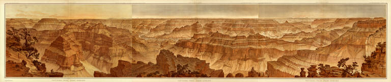
Author
[Dutton, Clarence E. (Clarence Edward), 1841-1912, Holmes, William Henry, 1846-1933]
Full Title
Panorama from Point Sublime. [Part II. Looking South.] W(illiam) H. H(olmes) Atlas Sheets XVI. Julius Bien & Co. lith. U.S. Geological Survey, Geology of the Grand Canon District.
List No
4713.017
Note
In full color. Second of three sheets.
Author
[Dutton, Clarence E. (Clarence Edward), 1841-1912, Holmes, William Henry, 1846-1933]
Full Title
Panorama from Point Sublime. [Part III. Looking West.] W(illiam) H. H(olmes). Atlas Sheets XVII. Julius Bien & Co. lith. U.S. Geological Survey, Geology of the Grand Canon District.
List No
4713.018
Note
In full color. Third of three sheets.
Author
[Dutton, Clarence E. (Clarence Edward), 1841-1912, Holmes, William Henry, 1846-1933]
Full Title
(Composite) Panorama From Point Sublime. [Parts I-III.] W.H. Holmes. Atlas Sheets XV-XVII. Julius Bien & Co. lith. U.S. Geological Survey, Geology of the Grand Canon District.
List No
4713.019
Note
In full color. Composite of all sections using Atlas Sheets 15-17.
Author
[Dutton, Clarence E. (Clarence Edward), 1841-1912, Moran, Thomas, 1837-1926]
Full Title
The Transept, Kaibab Division, Grand Canon. An amphitheater of the Second Order. (By Thomas Moran). Atlas Sheet XVIII. Julius Bien & Co. lith. U.S. Geological Survey, Geology of the Grand Canon District.
List No
4713.020
Note
In full color.
Author
[Dutton, Clarence E. (Clarence Edward), 1841-1912, Holmes, William Henry, 1846-1933]
Full Title
Views of the Marble Canon Platform from the eastern brink of the Kabib. W(illiam) H. H(olmes). Atlas Sheet XIX. Julius Bien & Co. lith. U.S. Geological Survey, Geology of the Grand Canon District.
List No
4713.021
Note
In full color. The views are continuous. The upper view looks east and the lower, south.
Author
Dutton, Clarence E. (Clarence Edward), 1841-1912
Full Title
Geologic Map Of The Mesozoic Terraces Of The Grand Canon District And The Southern Portions Of The High Plateaus. Atlas Sheet XXI. Geology by C.E. Dutton. Julius Bien & Co. lith. U.S. Geological Survey, Geology of the Grand Canon District.
List No
4713.023
Note
In full color. Second of four sheets.
Author
Dutton, Clarence E. (Clarence Edward), 1841-1912
Full Title
Geologic Map Showing The Kanab, Paria And Marble Canon Platforms. Atlas Sheet XXII. Geology by C.E. Dutton. Julius Bien & Co. lith. U.S. Geological Survey, Geology of the Grand Canon District.
List No
4713.024
Note
In full color. Third of four sheets.
|


![Geologic Map Of The Southern Part Of The Kaibab Plateau. [Part I. North-Western Sheet.]](https://www.davidrumsey.com/rumsey/Size1/D0009/00091151.jpg)
![Geologic Map Of The Southern Part Of The Kaibab Plateau. [Part II. North-Eastern Sheet.]](https://www.davidrumsey.com/rumsey/Size1/D0009/00091152.jpg)
![Geologic Map Of The Southern Part Of The Kaibab Plateau. [Part III. South-Western Sheet.]](https://www.davidrumsey.com/rumsey/Size1/D0009/00091153.jpg)
![Geologic Map Of The Southern Part Of The Kaibab Plateau. [Part IV. South-Eastern Sheet.]](https://www.davidrumsey.com/rumsey/Size1/D0009/00091154.jpg)

![Panorama from Point Sublime. [Part I. Looking East.]](https://www.davidrumsey.com/rumsey/Size1/D0009/00091156.jpg)
![Panorama from Point Sublime. [Part II. Looking South.]](https://www.davidrumsey.com/rumsey/Size1/D0009/00091157.jpg)
![Panorama from Point Sublime. [Part III. Looking West.]](https://www.davidrumsey.com/rumsey/Size1/D0009/00091158.jpg)