|
Author
Visscher, Nicolaes, 1649-1702.
Full Title
Novissima et accuratissima totius Ameriae. Per N. Visscher. (to accompany) Atlas minor sive totius orbis terrarum contracta delinea ex conatibus Nico. Visscher. 1690. (half title page) Atlas Minor sive Geographia Compendiosa, qua Orbis Terrarum.
List No
11755.123
Note
Hand colored in outline engraved map of the Western Hemisphere, showing California as an Island and a small slice of New Zealand at the lower left corner, open ended Great Lake, conjectural Northwest Passage, Straits on Anian. Shows political boundaries, cities, towns, waterways, canals, landmarks Indian settlements and mountains. Includes decorative carouches, compass roses and vignette of natives in South America. Relief shown pictorially.
Author
[Santini, Paolo, Janvier]
Full Title
43. L'Amerique.
List No
12039.126
Author
Seutter, Matthaeus, 1678-1756
Full Title
4. Novis Orbis sive America.
List No
12041.025
Author
Logerot, A.
Full Title
Nouvelle Carte Elementaire de L'Amerique du Nord a l'Usage des Ecoles. Nouvelle Carte Elementaire de L'Amerique du Sud a l'Usage des Ecoles.
List No
12051.018
Author
Palairet, Jean
Full Title
Carte Generale de l'Amerique 1754.
List No
12055.018
Author
Speed, John, 1542-1629
Full Title
America.
List No
12058.177
Author
[Briet, Philip, 1601-1668, Cramoisy, Sebastiani, Cramoisy, Gabrielis]
Full Title
La Division de L'Ocean du Nouveau Monde.
List No
12063.040
Author
Heck, Johann Georg, 1795 -1857
Full Title
55 et 59. Carte Generale des deux Ameriques.
List No
12128.060
Author
Homann, Johann Baptist, 1663-1724
Full Title
Americae.
List No
12138.039
Author
Tanner, Henry Schenck, 1786-1858
Full Title
America.
List No
12139.007
Author
Hagstrom Company, Inc.
Full Title
Shrinking Time and Distance.
List No
12166.001
Note
Date estimated.
Author
Hagstrom Company, Inc.
Full Title
Principal Airways Routes of the United States. (Text Page) Time chart ...
List No
12166.002
Note
Date estimated.
Author
[Ewald, Ludwig 1813-1881, Bauerkeller, Georg Leonhart]
Full Title
No. 31. America.
List No
12189.053
Author
[Ewald, Ludwig 1813-1881, Bauerkeller, Georg Leonhart]
Full Title
No. 37. America ... Uebersicht der Meer - u. Stromgebiete.
List No
12189.059
Author
[Ewald, Ludwig 1813-1881, Bauerkeller, Georg Leonhart]
Full Title
No. 44. America ... Uebersicht der americanischen Staaten und europaeischen Besitzungen.
List No
12189.066
Author
Fer, Nicolas de, 1646-1720
Full Title
L'Amerique, Meridionale et Septentrionale.
List No
12201.131
Author
Blaeu, Willem Janszoon, 1571-1638
Full Title
Americae nova Tabula.
List No
12202.007
Author
van Keulen, Joannes
Full Title
(Americas and the Pacific).
List No
12203.020
Author
Woodbridge, William C.
Full Title
Physical Map Of America & Africa And The Atlantic Ocean. Adapted To Woodbridge's Geography. Entered ... 1843, by W.C. Woodbridge ... Massachusetts. Hartford. Published By Wm. Jas. Hamersley. (to accompany) Modern Atlas, Physical, Political And Statistical; Exhibiting On Separate Maps ...
List No
1229.016
Note
Map Printed without color. Covers are heavy brown paper printed with "School Atlas, To Accompany The Modern School Geography, By William C. Woodbridge ... Hartford: Published By Belknap & Hamersley. Entered ... 1843, by William C. Woodbridge ... Massachusetts. Case, Tiffany & Co. Printers, Hartford, Conn." Prime meridians are Greenwich and Washington D.C. Relief shown by hachures.
Author
Woodbridge, William C.
Full Title
Physical Map Of America & Africa And the Atlantic Ocean. Adapted To Woodbridge's Geography. Entered .. . 1843, by W.C. Woodbridge ... Massachusetts. Hartford. Published By Wm. Jas. Hamersley.
List No
1231.016
Note
Map printed without color. Covers are heavy brown paper printed with "School Atlas, To Accompany The Modern School Geography, By William C. Woodbridge ... Hartford: Published By Wm. Jas. Hamersley. Entered ... 1843, by William C. Woodbridge ... Massachusetts. Case, Tiffany & Co. Printers, Hartford, Conn." Prime meridian is Greenwich. Relief shown by hachures.
Author
Pan American Airways System
Full Title
The Routes of the Flying Clipper Ships.
List No
12331.000
Note
Date estimated.
Author
Homann, Johann Baptist, 1663-1724
Full Title
Totius Americae Septentrionales et Meridionalis.
List No
12499.059
Author
[Homann, Johann Baptist, 1663-1724, Danckerts, J.]
Full Title
America Septentrionalis et Meridionalis.
List No
12499.209
Author
Johnston, Alexander Keith, 1804-1871
Full Title
River Systems of America. (insets) Niagara River and Falls. Mississippi Delta. Orinoco.
List No
12509.062
Author
Legrand, Augustin
Full Title
Exposition geographique XIV Tableau : Amerique. 2me. Degre d'enseignement. 3me. Partie. (to accompany) 1839 Exposition geographique ... Par Augustin Legrand ... Paris. (insets) Supplement pour les Etats- Unis. (with) Les Antillrd : Carte Supplementaire. (with) Oceanie: Monde maritime 5me. Section.
List No
13118.015
Note
Hand colored in outline map of America. Shows political and administrative boundaries, capitals, major cities and rivers. Includes notes. Relief shown by hachures and pictorially. Prime meridian is Paris. Includes color coded key to European possessions in West Indies and Oceania.
Author
[Brion de La Tour, Louis, 1743 – 1803, Desnos, Louis Charles]
Full Title
L'Amerique : dressee par l'etude de la Geographie. Revue et augmentee par Mr. Brion. A Paris, chez le Sr. Desnos. 1786. (to accompany) Atlas general, civil, ecclesiastique et militaire, methodique et elementaire pour l'etude de la geographie et de l'histoire ... par M. Brion, dirige par le sr. Desnos … A Paris 1786.
List No
13129.054
Note
Engraved hand color map of American continent. Shows California with large inlet, major cities and geographic features. There are illustrations of ships in the oceans. Includes decorative engraved title cartouche and border. Shows political and administrative boundaries. Relief shown pictorially.
Author
[Wyld, James, 1812-1887, Wyld, James, 1790-1836]
Full Title
Map of America. London. Published by James Wyld 1838. (to accompany) A new general atlas of modern geography : consisting of a complete collection of maps of the four quarters of the globe ...
List No
13170.053
Note
Double page engraved map, hand colored in outline. Shows political boundaries, major cities and towns, Russian-American possessions and The northern coast includes the discoveries of Franklin and Richardson, Dease and Simpson. Relief shown pictorially and by hachures.
Author
[Chatelain Henri, 1684-1743, Gueudeville, Nicolas]
Full Title
Carte Du Gouvernement de L'Amerique. No. 39. (to accompany) Atlas Historique ... Tome I. A Amsterdam, chez L'Honore & Chatelain. M DCC XVIII (1718).
List No
13272.109
Note
Engraved map of America, showing California as an Island. Includes 4 engraved views of the counsels of the West Indies, North America, South America and Terre Ferme, descriptive text and tables.
Author
[Chatelain Henri, 1684-1743, Gueudeville, Nicolas]
Full Title
Division generale de l'Amerique dans ses principales parties pour l'intelligence de la carte de ce païs.Tom. VI. No. 19. Pag. 75. (to accompany) Atlas Historique ... Tome VI. A Amsterdam, chez L'Honore & Chatelain Libraires. M DCC XIX (1719). .
List No
13272.673
Note
Engraved table of the political and administrative divisions of America into the northern and southern regions, and further subdivided into the various countries and provinces.
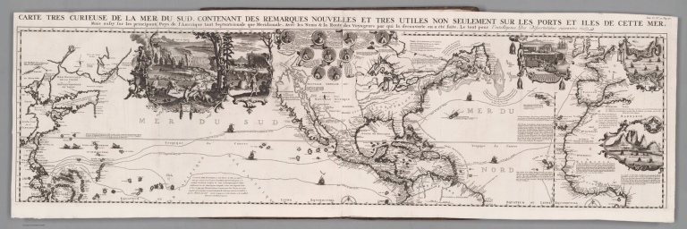
Author
[Chatelain Henri, 1684-1743, Gueudeville, Nicolas]
Full Title
Carte tres curieuse de la Mer du Sud, contenant des remarques nouvelles et tres utiles non seulement sur les ports et iles de cette mer, mais aussy sur les principaux pays de l'Amerique tant Septentroinale que Meridionale, Avec les noms & la route des voyageurs par qui la decouverte en a ete faite. Tom. VI. No. 30. Pag. 117. (to accompany) Atlas Historique ... Tome VI. A Amsterdam, chez L'Honore & Chatelain Libraires. M DCC XIX (1719).
List No
13272.711
Note
1 engraved map on 2 sheets. Covers the Pacific Ocean, centered on America. Includes portion of Europe, western Africa, and eastern coast of Asia. With decorative vignettes illustrations of tribal life and Native American costums, mining, hunting grounds, native industry and, fishery/ Includes maps and plans detailing the Spice Islands, Strait of Gibraltar, Cape of Good Hope, Isthmus of Panama, and ports of Baldavia, Veracruz, Conception, Buenos Aires, Havana and San Sabastian and Aztec Pyramid. At the top center portraits of important explorers including Columbus, Vespucci, Magellan, Drake, and Dampier, various trade and exploration routes in the Pacific and Atlantic shown on the map.
Author
[Chatelain Henri, 1684-1743, Gueudeville, Nicolas]
Full Title
Carte tres curieuse de la Mer du Sud, contenant des remarques nouvelles et tres utiles non seulement sur les ports et iles de cette mer, mais aussy sur les principaux pays de l'Amerique tant Septentroinale que Meridionale, Avec les noms & la route des voyageurs par qui la decouverte en a ete faite. Tom. VI. No. 30. Pag. 117. (to accompany) Atlas Historique ... Tome VI. A Amsterdam, chez L'Honore & Chatelain Libraires. M DCC XIX (1719).
List No
13272.712
Note
1 engraved map on 2 sheets. Covers the Pacific Ocean, centered on America. Includes portion of Europe, western Africa, and eastern coast of Asia. With decorative vignettes illustrations of tribal life and Native American costums, mining, hunting grounds, native industry and, fishery/ Includes maps and plans detailing the Spice Islands, Strait of Gibraltar, Cape of Good Hope, Isthmus of Panama, and ports of Baldavia, Veracruz, Conception, Buenos Aires, Havana and San Sabastian and Aztec Pyramid. At the top center portraits of important explorers including Columbus, Vespucci, Magellan, Drake, and Dampier, various trade and exploration routes in the Pacific and Atlantic shown on the map.
Author
Neutroses-Vichy
Full Title
Nos possessions dans les Ameriques. Edite par les Laboratories Neutroses-Vichy. Petit Jean Imp. Paris. Pour la clarte du document, les iles Francaises de l'Atlantique ont ete Agrandies 20 Fois par rapport aux autres territoires.
List No
13350.001
Author
Neutroses-Vichy
Full Title
(Text page to) Nos possessions dans les Ameriques. Edite par les Laboratories Neutroses-Vichy. Petit Jean Imp. Paris. Pour la clarte du document, les iles Francaises de l'Atlantique ont ete Agrandies 20 Fois par rapport aux autres territoires.
List No
13350.002
Author
[Haardt, Vinzenz von., 1843-1914, Orožen, Franc]
Full Title
Amerika (Politicni pregled) . Haardtov atlas za ljudske šole st. 9. Ed. Hölzlov Zemljep. Zavod na Dunaju. Zalozil Ed. Holzel na Dunaju.
List No
13460.014
Note
Political map of America, with inset maps of Avstrijsko-Ogersko -- Mejikansko visavje. Includes color coded key to european possessions in America.
Author
Haase, F.
Full Title
A map of the Americas. Designed by F. Haase. Copyright 1940 by R.R. Bowker Co.., New York.
List No
13517.000
Author
Stieler, Adolf, 1775–1836
Full Title
America : gezeichnet von F. v. Stulpnagel. gest v. W. Behrens. Stieler's Hand-Atlas No. 78. Gotha: Justus Perthes. 1874.
List No
13563.101
Note
Outline color map of the Americas.
Author
[Glavnoe Upravlenie Navigat︠s︡ii i Okeanografii Ministerstva Oborony SSSR., Soviet Union. Voenno-Morskoĭ Flot.]
Full Title
Vostochnaya chast' Tikhogo Okeana. (To accompany) Atlas okeanov : Tikhiy Okean = Atlas of the Oceans : Pacific Ocean. 1974.
List No
13622.219
Note
Map of the Eastern Pacific Ocean on 2 sheets. Showing international boundaries. Relief shown by gradient tints and spot heights. Depth shown by bathymetric tints, isolines and soundings. Include elevation bar.
Author
[Československá akademie věd., Klíma, Jan]
Full Title
(Index Map to) Severní a Jižní Amerika. Československý vojenský atlas̊.
List No
13684.147
Note
Index map of America.
Author
[Československá akademie věd., Klíma, Jan]
Full Title
Amerika - Politické rozdělení. Československý vojenský atlas̊.
List No
13684.151
Note
Political and administrative map of America. Shows boundaries and distances. Includes reference to population, states, capitals and major cities and legend.
Author
[Československá akademie věd., Klíma, Jan]
Full Title
Severní a Jižní Amerika - Podnebí. Československý vojenský atlas̊.
List No
13684.152
Note
4 maps on 1 sheet. Showing average air temperature and average air pressure and direction of wind in January and July.
Author
Andriveau-Goujon, E. (Eugène), 1832-1897
Full Title
Tableau comparatif de la hauteur des montagnes de la longueur du cours des fleures et de l'elevation des principales chûtes d'eau dans les cinq parties di monde faisant partie de l'atlas classique de C. V. Monin.
List No
14008.002
Note
Hand-colored, engraved diagram showing the comparative heights of mountains, lengths of rivers and heights of waterfalls in Europe, Asia, Africa and America. Includes index to mountains in left and right margins (with data and geographic locations), as well as descriptive text below: Observations physiques relatives aux montagnes. Diagram pasted onto verso of front cover, over marbled paper.
Author
[Morden, Robert, approximately 1650-1703, Cockerill, Thomas, active 1674-1702]
Full Title
(Text Page to) Of Maltha (2) -- Of America (1).
List No
14323.173
Note
On left - descriptive text for map, Maltha, on prior page (359). Text spans pages 359-360. On right - map of the Americas. Map includes title: America, by R. Morden. Shows political boundaries, cities, topography, drainage, coastline and islands. Relief shown pictorially. Contains latitudinal and longitudinal lines. Map is 10 x 12 cm, on sheet 15 x 20 cm. Accompanied by descriptive text. Text spans pages 361-364.
Author
Bartholomew, John
Full Title
The Americas. Lambert Zenithal Equal-Area Projection, Centre 20 (degree) N. 75 (degree) W. The Geographical Institute Edinburgh. Edited by John Bartholomew, M.C. LL. D. Copyright - John Bartholomew & Son, LTD.
List No
1552.245
Note
Full color map. Relief shown by shadings. The sea contour is drawn at 200 meters. Prime meridian is Greenwich. No. 1440 and Sep 56 marked on the lower corners of plate. The Times Atlas, and Frotispiece Vol. V on the upper corners of plater.
Author
Cary, John, ca. 1754-1835
Full Title
The Western Hemisphere. London: Published by J. Cary, Engraver & Map-seller, No. 181, Strand, Augst. 1, 1799.
List No
1657.002
Note
Engraved circular map. Country boundaries in outline hand col. Relief shown pictorially. Shows routes of Clerke, Cook, Gores, La Perouse, Pickersgills and Vancouver. Geographic and historic notes throughout the map. "2" pasted on verso.
Author
Cary, John, ca. 1754-1835
Full Title
A new map of America, from the latest authorities. By John Cary, engraver, 1806. London: Published by J. Cary, Engraver & Map-seller, No. 181, Strand, Septr. 1st, 1806.
List No
1657.052
Note
Engraved map. Boundaries in outline hand col. Relief shown pictorially. "50" pasted on verso.
Author
[Bory de Saint-Vincent, M. (Jean Baptiste GeneviFve Marcellin), 1778-1846, Desmarest, Nicolas, 1725-1815, Vincent]
Full Title
Theorie des vents (Amerique. A Paris, Chez Mme. veuve Agasse, Imprimeur-Libraire, rue des Poitevins, no. 6. M.DCCCXXVII)
List No
1801.004
Note
Engraved map. Prime meridians: Ferro and Paris.
Author
[Geographisches Institut (Weimar, Germany), Kiepert, Heinrich, 1818-1899]
Full Title
America. Bearbeitet und gezeichnet von H. Kiepert. Gestochen v. C. Jungmann. Weimar, Verlag des Geographischen Instituts, 1856.
List No
2077.059
Note
Engraved map. Outline hand col. Relief shown by hachures. Shows settlements, boundaries, ocean currents, etc. Prime meridian: Ferro.
Author
[Anville, Jean Baptiste Bourguignon d, 1697-1782, Faden, William, 1750?-1836]
Full Title
A map of America or the New World, wherein are introduced all the known parts of the Western Hemisphere, from the map of D'Anville; with the necessary alterations, and the addition of the discoveries made since the year 1761. London: published by W. Faden, Geographer to the King and to H.R.H. the Prince of Wales, Charing-Cross, April 12th, 1797. Wm. Palmer sculp.
List No
2104.052
Note
Engraved map. Hand col. Relief shown pictorially. Shows settlements, Indian tribes, 1493 line of demarcation between Spanish and Portuguese possessions, etc. Prime meridian: Ferro. "49" on verso.
Author
Vandermaelen, Philippe, 1795-1869
Full Title
(Composite of) Amer. Sep. no. 1 - 76 and Amer. Merid. no. 1 - 43. (Dresse par Ph. Vandermaelen, lithographie par H. Ode. 1827)
List No
2212.394
Note
This composite of all 119 maps of North and South America was created by georeferencing the maps individually in a Polyconic projection with the central meridian at 88.5 degrees west. Then all the maps were trimmed beyond their neat lines and joined. Relief shown pictorially; depths by soundings. Prime meridian: Paris.
Author
[Ortelius, Abraham, Schoner, Johann]
Full Title
Maris Pacifici, quod vulgo Mar del Zur, cum regionibus circumiancentibus insulisque in eodem passim sparsis, novissima descriptio. From map of North America by Abrahamus Ortelius, 1589. Reduced. America from a globe in Frankfurt, about 1520. Reduced. Julius Bien, Photo-lith. U.S. Geographical Surveys West of the 100th Meridian. (1889)
List No
2220.034
Note
Color Lithograph reproductions of 2 maps on 1 sheet. Relief shown by hachures. As pl. XXXI in list of plates.
Author
[Hondius, Jodocus, 1563-1612, Mercator, Gerhard, Mercator, Michael]
Full Title
America sive India Nova, ad magnae Gerardi Mercatoris aui Universalis imitationem in compendium redacta. Per Michaelem Mercatorem Duysburgensem. From "Hondius" Ed. 1609 Amst. Reduced. U.S. Geographical Surveys West of the 100th Meridian. (1889)
List No
2220.036
Note
Lithograph reproduction. Relief shown pictorially. Includes 4 insets. As pl. XXXIII in list of plates.
Author
Robert Laurie & James Whittle
Full Title
(A new map of the whole continent of America, divided into north and south and West Indies. North half. Wherein are exactly described the United States of North America as well as the several European possessions according to the Preliminaries of Peace signed at Versailles Jan. 20, 1783. Compiled from Mr. d'Anville's maps of that continent, with the addition of the Spanish discoveries in 1775 to the north of California & corrected in the several parts belonging to Great Britain, from the original materials of Governor Pownall, MP. London, Publish'd by Laurie & Whittle, No. 53, Fleet Street, as the act directs 12th May, 1794)
List No
2310.077
Note
Hand colored engraved map. Relief shown pictorially. Shows colonies, cities, Indian tribes, rivers, etc. Includes table: The continent and islands of America as divided and possessed ... Prime meridian: Ferro. Printed on 2 sheets; joined.
Author
[Anville, Jean Baptiste Bourguignon d, 1697-1782, Pownall, Thomas, Robert Laurie & James Whittle]
Full Title
A new map of the whole continent of America, divided into north and south and West Indies. (South half). (with) The supplement to North America containing the countries adjoining to Baffins & Hudsons bays. Wherein are exactly described the United States of North America as well as the several European possessions according to the Preliminaries of Peace signed at Versailles Jan. 20, 1783. Compiled from Mr. d'Anville's maps of that continent, with the addition of the Spanish discoveries in 1775 to the north of California & corrected in the several parts belonging to Great Britain, from the original materials of Governor Pownall, MP. London, Publish'd by Laurie & Whittle, No. 53, Fleet Street, as the act directs 12th May, 1794.
List No
2310.078
Note
Hand colored engraved map with inset. Relief shown pictorially. Shows colonies, cities, Indian tribes, rivers, etc. Includes table: The continent and islands of America as divided and possessed ... Illustrated cartouche. Prime meridian: Ferro. Printed on 2 sheets; joined.
Author
[Anville, Jean Baptiste Bourguignon d, 1697-1782, Pownall, Thomas, Robert Laurie & James Whittle]
Full Title
(Composite of) A new map of the whole continent of America, divided into north and south and West Indies. (South half). (with) The supplement to North America containing the countries adjoining to Baffins & Hudsons bays. Wherein are exactly described the United States of North America as well as the several European possessions according to the Preliminaries of Peace signed at Versailles Jan. 20, 1783. Compiled from Mr. d'Anville's maps of that continent, with the addition of the Spanish discoveries in 1775 to the north of California & corrected in the several parts belonging to Great Britain, from the original materials of Governor Pownall, MP. London, Publish'd by Laurie & Whittle, No. 53, Fleet Street, as the act directs 12th May, 1794.
List No
2310.079
Note
Digital composite of 2 hand colored engraved maps. Relief shown pictorially. Shows colonies, cities, Indian tribes, rivers, etc. Includes table: The continent and islands of America as divided and possessed ... Illustrated cartouche. Prime meridian: Ferro. Printed on 4 sheets; joined as 2.
Author
[Stieler, Adolf, Petermann, A.]
Full Title
Polynesien Und Der Grosse Ocean Im Maassstabe von 1:40.000.000. (Ostliches Blatt) Von A. Petermann. Gezeichnet v. E. Debes. Gest v. C. Stier. Gotha: Justus Perthes 1872.
List No
2449.083
Note
Map of islands in the eastern Pacific Ocean showing the United States and the coastline of South America. 17 inset maps detail the individual islands in the region.
Author
Hunt, Marianne
Full Title
(Text Page to) Amerique Physique. (to accompany) Cours de Geographie. Institution de Mme. Butler. Saint-Omer. Marianne Hunt. 1844.
List No
2503.027
Note
Text to physical geography of America.
Author
Hunt, Marianne
Full Title
(Text Page to) Amerique Physique. (to accompany) Cours de Geographie. Institution de Mme. Butler. Saint-Omer. Marianne Hunt. 1844.
List No
2503.028
Note
Text to physical geography of America.
Author
Hunt, Marianne
Full Title
Amerique Physique. (to accompany) Cours de Geographie. Institution de Mme. Butler. Saint-Omer. Marianne Hunt. 1844. (inset) Is. du N. Shetland Merid.
List No
2503.029
Note
Physical map of America. Outline hand color, on page 27x34. Relief shown by hachures. Includes notes and inset.
Author
Hunt, Marianne
Full Title
(Text Page to) Amerique Physique. (to accompany) Cours de Geographie. Institution de Mme. Butler. Saint-Omer. Marianne Hunt. 1844.
List No
2503.030
Note
Text to Physical geography of America.
Author
Hunt, Marianne
Full Title
(Text Page to) Amerique Physique. (with) Amerique Politique. (to accompany) Cours de Geographie. Institution de Mme. Butler. Saint-Omer. Marianne Hunt. 1844.
List No
2503.031
Note
Text to Physical and political geography of America.
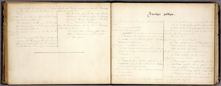
Author
Hunt, Marianne
Full Title
(Text Page to) Amerique Politique. (to accompany) Cours de Geographie. Institution de Mme. Butler. Saint-Omer. Marianne Hunt. 1844.
List No
2503.032
Note
Text to political geography of America.
Author
Hunt, Marianne
Full Title
Amerique Politique. (to accompany) Cours de Geographie. Institution de Mme. Butler. Saint-Omer. Marianne Hunt. 1844.(inset) Is. du N. Shetland Merid.
List No
2503.033
Note
Political map of America. Outline hand color, on page 27x34. Shows political boundaries and major cities. Includes explanation, notes and inset.
Author
Arrowsmith, Aaron Jr.
Full Title
America. London, Published Jany. 4.1825 by A. & S. Arrowsmith, No.10 Soho Square.
List No
2550.041
Note
Hand color map, with colored boundaries. Showing regions, place names, rivers, etc. Relief shown by hachures. Prime meridian is Greenwich.
Author
[Geographisches Institut (Weimar, Germany), Graf, Carl]
Full Title
America. Bearbeitet und gezeichnet von H. Kiepert. Revidirt v. C. Graf, 1865. Gestochen v. C. Jungmann. Weimar: Geographisches Institut. (to accompany) Hand - Atlas Der Erde Und Des Himmels.
List No
2595.063
Note
Outline hand color map by region. Color coded by European possessions. Shows cities, towns, roads, rivers, etc. Includes legend, abbreviation, and list of states and provinces. Relief shown by hachures.
Author
Janvier, Jean
Full Title
L'Amerique divisee par grand etats. Par le Sr. Janvier Geographe. A Paris, Chez Lattre Graveur, rue St. Jacques, pres la Fontaine Saint Severin, a la Ville de Bordeaux. Avec privilege du Roy. 1783.
List No
2612.069
Note
Engraved map. Boundaries outlined in hand col. Relief shown pictorially. Ornamental cartouche. Prime meridian: Ferro. Engraver name illegible.
Author
[Thomson, John, Wyld, James, 1790-1836]
Full Title
America. Drawn by Wyld. (engraved by) Hewitt Sc. ... Published by John Thomson & Co. Edinburgh. (to accompany) A General Atlas, Containing Maps illustrating some important periods in Ancient History; and distinct Maps of the several Empires, Kingdoms and States In The World, From Original Drawings according to the latest Treaties by J. Wyld and Engraved by N.R. Hewitt. Edinburgh, Printed for John Thomson & Co for Baldwin, Cradock & Joy, London & John Cumming, Dublin.
List No
2713.058
Note
Outline color map of the Americas including Canada, the United States, Central America and South America. With a vignette "Cascade of Regla, near Mexico." The atlas is the second edition and includes the extra map of the Arctic and two extra maps of Australia. The text adds a section on Voyages of Discovery. Two additional maps are laid in, one of South America, the other of Mexico. Each map has a small vignette illustrating a subject related to the map. Half leather paper-covered boards with label pasted on front printed with title. Prime meridian is Greenwich. Relief shown pictorially.
Author
[Dower, John Nicaragua, Teesdale, Henry]
Full Title
America. London: Published by Henry Teesdale & Co. Drawn & Engraved by J. Dower, Pentonville, London. (1844)
List No
2745.034
Note
Engraved, with colored margins of countries. Shows place names, roads, rivers, lakes, and islands. Relief shown with hachures. British possessions shown in red (Jamaica, Canada, Guiana, Bahamas, Belize, etc.).
Author
Fer, Nicolas de, 1646-1720
Full Title
L'Amerique, Meridionale et Septentrionale. Dressee selon les dernieres relations et suivant les nouvelles decouvertes dont les points principaux sont placez sur les observations de Mrs. de l'Academie Royale des Sciences. Par N. de Fer. A Paris, Chez l'Auteur dans l'Isle du Palais sur le Quay de l'Orloge a la Sphere Royale. Avec priv. du Roy. 1717. C. Inselin scripsit.
List No
2900.006
Note
Engraved map. Relief shown pictorially. Shows California as an island. "Dressee et dediee a Nosseigneurs les enfans de France." Prime meridian: Ferro. "11."
Author
[Lotter, Tobias Conrad, Lobeck, Tobias]
Full Title
America. (engraved by) Tobias Lobeck. Tob. Conr. Lotter. Scups. (to accompany) Atlas Geographicus Portatilis, XXIX, Mappis Orbis Habitabilis Regna Exhibens. Caelo Accurate Expressit Tobias Conradus Lotterus, Delineavit et Excudit Tobias Lobeck, Chalcograph: Augustan... (Augsburg, 17620) (engraved by)Tobias Lobeck. Sculpsit et execudit, Aug. A.Y. (after) G. Eichler.
List No
3010.009
Note
Full color map. Date is estimated. Miniature pocket atlas. Consists entirely of double-page engraved plates and hand-colored maps. This was also published with text, not present here. Engraved frontispiece and title page by Tobias Lobeck after G. Eichler, followed by maps that are dense with information. Bound in leather untitled covers, spine chipped.
Author
[Dower, John, Teesdale, Henry]
Full Title
America. Drawn & engraved by J. Dower. London, Published by Henry Teesdale & Co. (to accompany) A New General Atlas of the World, from Drawings made Expressly for this Work, By John Dower.
List No
3326.037
Note
Outline hand color map. Shows boundaries, rivers and principal settlements. Relief shown by hachures. Prime meridian is Greenwich.
Author
Bowen, Emanuel
Full Title
A new general map of America. Drawn from several accurate particular maps and charts, and regulated by astronomical observations. By Eman. Bowen. (London: Printed for William Innys, Richard Ware, Aaron Ward, J. and P. Knapton, John Clarke, T. Longman and T. Shewell, Thomas Osborne, Henry Whitridge ... M.DCC.XLVII)
List No
3733.050
Note
Engraved map. Relief shown pictorially. Includes historical notes and ornamental cartouche.
Author
[Johnston, Alexander Keith, 1804-1871, Rogers, Henry Darwin]
Full Title
Index Map. Explanation of Signs Used In The Atlas. Entered in Sta. Hall. London ... & according to an act of Congress ... 1857, by H.D. Rogers ... Massachusetts. London, John Murray, Albemarle Street, Edinburgh, W. & A.K. Johnston. Engraved by W. & A.K. Johnston, Edinburgh.
List No
3825.002
Note
The index map is broken into 24 outline color sections and numbered. A note is included explaining the symbols on the subsequent map.
Full Title
(L'Amerique. A Lyon, Chez Jean-Marie Bruyset, Pere & Fils. M.DCC.LXXXIV)
List No
4122.022
Note
Engraved map. Hand colored. Relief shown pictorially. Prime meridian: Ferro.
Author
[Homann, Johann Baptist, 1663-1724, Hubner, Johann, 1688-1731]
Full Title
(Charte von Europa. Charte von Asia. Charte von Africa. Charte von America. Johanne Baptista Homanno, Norimbergae, 1719)
List No
4385.002
Note
Four hand col. engraved outline maps. Show country boundaries and major rivers. Numbered 4-7. Map of America shows California as an island.
Author
[Berghaus, Heinrich, Drude, Oscar]
Full Title
Florenkarte von Amerika. Entw. v. O. Drude. 1884, Ausg. 1887. (On upper margin) V. Abt. Pflanzenverbreitung No. VII. Berghaus' physikal atlas No. 50. Atlas der Pflanzenverbreitung (Berghaus' physikalischer atlas, Abteilung V). (to Accompany) Berghaus' Physikalischer Atlas. (Begrundet 1836 durch Heinrich Berghaus) ... Gotha: Justus Perthes. 1892. (2 insets)
List No
4391.085
Note
2 color lithograph maps on 1 sheet folded, with 2 profiles showing comparative heights of the mountains in North and South America. Showing geographical distribution of flora in North America, South America and Central America. Includes explanation tables and notes. Relief shown by spot heights. Prime meridian is Greenwich.
Author
[Berghaus, Heinrich, Gerland, Georg]
Full Title
Wohnsitze der Amerikanischen Urbevolkerun in den zeiten entdeckung. Entw. v. Dr. G. Gerland,1884, Ausg. 1887. (On upper margin) VII. Abt. Volkerkunde. No. XII Berghaus' physikal atlas No. 72. Atlas der Volkerkunde (Berghaus' physikalischer atlas, Abteilung VII). (to Accompany) Berghaus' Physikalischer Atlas. (Begrundet 1836 durch Heinrich Berghaus) ... Gotha: Justus Perthes. 1892.
List No
4391.121
Note
2 full color maps on 1 sheet folded. Showing the dispersement of Indigenous populations in America. Tribal boundaries are distinguished by color. Includes explanatory tables. Prime meridian is Greenwich.
Author
[Berghaus, Heinrich, Gerland, Georg]
Full Title
Amerika um 1800. Entw. v. Dr. G. Gerland,1885, Ausg. 1887. (On upper margin) VII. Abt. Volkerkunde. No. XIII Berghaus' physikal atlas No. 73. Atlas der Volkerkunde (Berghaus' physikalischer atlas, Abteilung VII). (to Accompany) Berghaus' Physikalischer Atlas. (Begrundet 1836 durch Heinrich Berghaus) ... Gotha: Justus Perthes. 1892.
List No
4391.122
Note
2 full color maps on 1 sheet folded. Showing the ethnographic distribution of people in North, Central and South America. Includes explanatory tables. Prime meridian is Greenwich.
Author
[Stucchi, Achille, Bordiga, F.]
Full Title
America Settentrionale E Meridionale Nuovamente corretta ed accresciuta. 1856. F. Bordiga inc. Milano presso Achille Stucchi Piazza di S. Gio. in Era No. 412. Casa Picinini. (with two inset maps).
List No
4468.000
Note
Shows North and South America, with two inset maps of Isola Di St. Domingo and Isola Della Martinica. A pretty map, and very out of date - the western U.S. portions look like they were copied from an 1815 map. Tooley lists several members of the Stucchi family as engravers in Milan, but not Achille. This map was probably issued in the 1820's or 30's, and them reissued with minimal updating in 1856. Printed with outline color. Relief shown by hachures.
Author
[Covens et Mortier, L'Isle, Guillaume de, 1675-1726]
Full Title
Hemisphere Occidental. Dresse en 1720 pour l'usage particulier du Roy sur les observations astronomiques et geographiques raportees la meme annee dans l'Histoire et dans les memoires de l'Academie Rle. des Sciences. Par Guillaume de l'Isle, premier Geographe de sa Majeste de la meme Academie. A Amsterdam, Chez J. Covens et C. Mortier. I. Condet sc.
List No
4638.005
Note
Hand colored engraved map. Relief shown pictorially. Shows explorers' tracks.
Author
[Covens et Mortier, L'Isle, Guillaume de, 1675-1726]
Full Title
Carte d'Amerique, dressee pour l'usage du Roy. Par Guillaume Delisle, premier Geographe de Sa Majeste de l'Academie Royale des Sciences. A Amsterdam, Chez Jean Covens et Corneille Mortier, Geographes. (Title in upper margin:) America accurate in imperia, regna, status & populos divisa, ad usum Ludovici LXV, Galliarum Regis. 1739.
List No
4638.092
Note
Engraved map in outline color. Relief shown pictorially. Shows demarcation line of Pope Alexander VI between Spain and Portuguese territories. Prime meridian: Ferro. Includes "Avertissement" in draped curtain concerning the projection and scale.
Author
Clouet, J. B. L. (Jean-Baptiste Louis), b. 1730
Full Title
Lacs, fleuves, rivieres et principales montagnes de l'Amerique. Introduction. (1787)
List No
4757.015
Note
Abbot Jean Baptiste Louis Clouet (c. 1730 – 1790) was a French cartographer active in the mid to late 18th century. Clouet held the post of Royal Geographer of the Academie des Sciences de Rouen, he had offices in Paris and Cadiz. Clouet’s most important work is his Geographie Moderne, which was published in various editions from 1776 – 1793. Clouet also produced a series of stunning and highly decorative wall maps depicting the various continents. He followed in the footsteps of Jean-Baptiste Nolin and other French cartographers, reissuing these grand wall-maps in the latter part of the 18th century to decorate the houses of Paris and more unusually Spain.
Author
Clouet, J. B. L. (Jean-Baptiste Louis), b. 1730
Full Title
Isles, caps et ports de mer de l'Amerique. Introduction. (1787)
List No
4757.019
Note
Abbot Jean Baptiste Louis Clouet (c. 1730 – 1790) was a French cartographer active in the mid to late 18th century. Clouet held the post of Royal Geographer of the Academie des Sciences de Rouen, he had offices in Paris and Cadiz. Clouet’s most important work is his Geographie Moderne, which was published in various editions from 1776 – 1793. Clouet also produced a series of stunning and highly decorative wall maps depicting the various continents. He followed in the footsteps of Jean-Baptiste Nolin and other French cartographers, reissuing these grand wall-maps in the latter part of the 18th century to decorate the houses of Paris and more unusually Spain.
Author
Clouet, J. B. L. (Jean-Baptiste Louis), b. 1730
Full Title
De l'Amerique en general. (1787)
List No
4757.068
Note
Abbot Jean Baptiste Louis Clouet (c. 1730 – 1790) was a French cartographer active in the mid to late 18th century. Clouet held the post of Royal Geographer of the Academie des Sciences de Rouen, he had offices in Paris and Cadiz. Clouet’s most important work is his Geographie Moderne, which was published in various editions from 1776 – 1793. Clouet also produced a series of stunning and highly decorative wall maps depicting the various continents. He followed in the footsteps of Jean-Baptiste Nolin and other French cartographers, reissuing these grand wall-maps in the latter part of the 18th century to decorate the houses of Paris and more unusually Spain.
Author
Dussieux, L.
Full Title
Cartes pour Servir a l'Histoire de l'Amerique et des Colonies jusqu'en 1765. 150. Carte du'ne Partie de l'Amerique du Nord avant la paix de Breda (1667). 151. Carte pour servir a l'histoire de l'Amerique et des Colonies depuis kes traites d'Utrecht (1713) jusqu'aux traites de Paris (1763). 152. Carte de l'Amerique du Nord d'apres le traite de Paris en 1763.
List No
4759.138
Author
Radefeld, Carl Christian Franz, 1788-1874
Full Title
Neueste Karte von America. Nach den bessten Quellen entworf u. gezeich. vom Hauptm. Radefeld. 1843. Stahlstich, Direction v. Kleinknecht aus der Schweinfurter Geographischen Graviranstalt des Bibliograph. Instituts zu Hildburghausen, Amsterdam, Paris und Philadelphia, (1860)
List No
4807.125
Note
Engraved map. Boundaries hand col. Relief shown by hachures. "Meyer's Handatlas No. 2." Prime meridian: Ferro.
Author
[Meyer, Joseph, 1796-1856, Davia, Joh., Arrowsmith, John]
Full Title
America 1849 : Nach Arrowsmith, Brue und Lapie, mit Benutzung der neuesten Vermessungen. Joh. David sculp. Stich, Druck und Verlag der geographischen Anstalt des Bibliographischen Instituts. (In upper margin) Meyer's Zeitungs Atlas. No. 28. (to accompany: Meyer's Zeitungs und Groschen Atlas aller Lander und Staaten der Erde).
List No
4808.014
Note
Engraved map. Boundaries outline hand colored. Relief shown by hachures. Prime meridian is Ferro.
Author
Asher & Adams
Full Title
(Covers to) Asher & Adams' New Columbian Rail Road Atlas and Pictorial Album of American Industry, Comprising a Series of New Copper Plate Maps Exhibiting the Thirty-Seven States ... Together With Illustrations and Descriptions of Mercantile and Manufacturing Establishments, Machinery, Works of Art, Mechanism, Trade-Marks, Etc., Etc. ... Compiled, Written, Drawn and Engraved Under the Supervision Of The Publishers, By Their Own Corps of Editors, Engineers, Topographers, and Artists.... New York: Asher & Adams, No. 59 Beekman Street. 1875
List No
4977A
Note
Brown leather half binding with dark green cloth boards with bold gilt lettering: ASHER & ADAMS' NEW RAIL ROAD ATLAS AND PICTORIAL ALBUM OF AMERICAN INDUSTRY. Marbled lining paper.
Author
Asher & Adams
Full Title
(Title Page to) Asher & Adams' New Columbian Rail Road Atlas and Pictorial Album of American Industry, Comprising a Series of New Copper Plate Maps Exhibiting the Thirty-Seven States ... Together With Illustrations and Descriptions of Mercantile and Manufacturing Establishments, Machinery, Works of Art, Mechanism, Trade-Marks, Etc., Etc. ... Compiled, Written, Drawn and Engraved Under the Supervision Of The Publishers, By Their Own Corps of Editors, Engineers, Topographers, and Artists.... New York: Asher & Adams, No. 59 Beekman Street. 1875
List No
4977B
Note
Extremely lengthy and detailed description of the atlas contents on the title page. Engraved.
Author
Asher & Adams
Full Title
(Title Page Verso to) Asher & Adams' New Columbian Rail Road Atlas and Pictorial Album of American Industry, Comprising a Series of New Copper Plate Maps Exhibiting the Thirty-Seven States ... Together With Illustrations and Descriptions of Mercantile and Manufacturing Establishments, Machinery, Works of Art, Mechanism, Trade-Marks, Etc., Etc. ... Compiled, Written, Drawn and Engraved Under the Supervision Of The Publishers, By Their Own Corps of Editors, Engineers, Topographers, and Artists.... New York: Asher & Adams, No. 59 Beekman Street. 1875
List No
4977C
Note
Entered according to the Act of Congress in the year one thousand eight hundred and seventy-four by Asher & Adams, in the Office of the Librarian of Congress at Washington. Electrotyped at the Franklin Type Foundry, Cincinnati. Engraved.
Author
Asher & Adams
Full Title
(Preface to) Asher & Adams' New Columbian Rail Road Atlas and Pictorial Album of American Industry, Comprising a Series of New Copper Plate Maps Exhibiting the Thirty-Seven States ... Together With Illustrations and Descriptions of Mercantile and Manufacturing Establishments, Machinery, Works of Art, Mechanism, Trade-Marks, Etc., Etc. ... Compiled, Written, Drawn and Engraved Under the Supervision Of The Publishers, By Their Own Corps of Editors, Engineers, Topographers, and Artists.... New York: Asher & Adams, No. 59 Beekman Street. 1875
List No
4977D
Note
Description of the content and depiction assumptions used in compiling this atlas. Engraved.
Author
Asher & Adams
Full Title
(Index to) Asher & Adams' New Columbian Rail Road Atlas and Pictorial Album of American Industry, Comprising a Series of New Copper Plate Maps Exhibiting the Thirty-Seven States ... Together With Illustrations and Descriptions of Mercantile and Manufacturing Establishments, Machinery, Works of Art, Mechanism, Trade-Marks, Etc., Etc. ... Compiled, Written, Drawn and Engraved Under the Supervision Of The Publishers, By Their Own Corps of Editors, Engineers, Topographers, and Artists.... New York: Asher & Adams, No. 59 Beekman Street. 1875
List No
4977E
Note
Index in three categories listing: 60 sheets of Maps; 41 pages of Objects of Interest, History, Statistics, and Reviews of Population, Industry, Wealth, etc.; and 124 examples of American Industry, etc. Engraved.
Author
Garnier, F. A., 1803-1863
Full Title
Amerique. Atlas spheroidal & universel de geographie dresse par F.A. Garnier, geographe. Vve. Jules Renouard, Editeur, Rue de Tournon, no. 6, Paris. 1860. Imp. Sarazin, r. Git-le-Coeur, 8, Paris.
List No
5023.049
Note
Full col. Relief shown by hachures. Shows tribes, etc. Prime meridian: Paris. On globe in cartouche: Sphericite de la terre.
Author
Codazzi, Agustin, 1793-1859
Full Title
America historica, fisica y politica actual. 1840. Gravee par Muschani. Imprimee chez Thierry freres a Paris. (Caracas 1840)
List No
5226.002
Note
Lithographed map. Hand col. Includes notes on size and population of countries, and geographical notes. Relief shown by hachures.
Author
Colton, G.W.
Full Title
(Covers to) Colton's Advertising Atlas Of America. Colton's Atlas Of America. Illustrating The Physical And Political Geography Of North And South America And The West India Islands, By George W. Colton. Accompanied By Descriptions Geographical, Statistical, And Historical, By Richard Swainson Fisher, M.D. New York: J.H. Colton And Company, No. 172 William, Corner Beekman Street. 1857. Entered ... One Thousand Eight Hundred and Fifty-five, by J.H. Colton And Company ... New York.
List No
5479A
Note
Quarter bound in leather with embossed brown cloth with "Colton's Advertising Atlas of America" in gilt on the spine and the cover. Binding separated at front.
Author
Colton, G.W.
Full Title
(Half Title Page to) Colton's Advertising Atlas Of America. Colton's Atlas Of America. Illustrating The Physical And Political Geography Of North And South America And The West India Islands, By George W. Colton. Accompanied By Descriptions Geographical, Statistical, And Historical, By Richard Swainson Fisher, M.D. New York: J.H. Colton And Company, No. 172 William, Corner Beekman Street. 1857. Entered ... One Thousand Eight Hundred and Fifty-five, by J.H. Colton And Company ... New York.
List No
5479B
Note
Text is "Colton's American Atlas, Published by J.H. Colton & Co. No. 172 William St. New York. C. Wise, Sc.". Illustration of Native American Indians overlooking a valley showing numerous indications of "civilization".
Author
Colton, G.W.
Full Title
(Verso Half Title Page to) Colton's Advertising Atlas Of America. Colton's Atlas Of America. Illustrating The Physical And Political Geography Of North And South America And The West India Islands, By George W. Colton. Accompanied By Descriptions Geographical, Statistical, And Historical, By Richard Swainson Fisher, M.D. New York: J.H. Colton And Company, No. 172 William, Corner Beekman Street. 1857. Entered ... One Thousand Eight Hundred and Fifty-five, by J.H. Colton And Company ... New York.
List No
5479C
Note
Partially intact pasted-in notice to "Gents" from the publisher.
Author
Colton, G.W.
Full Title
(Title Page to) Colton's Atlas Of America. Illustrating The Physical And Political Geography Of North And South America And The West India Islands, By George W. Colton. Accompanied By Descriptions Geographical, Statistical, And Historical, By Richard Swainson Fisher, M.D. New York: J.H. Colton And Company, No. 172 William, Corner Beekman Street. 1857. Entered ... One Thousand Eight Hundred and Fifty-five, by J.H. Colton And Company ... New York.
List No
5479D
Author
Colton, G.W.
Full Title
(Verso Title Page to) Colton's Atlas Of America. Illustrating The Physical And Political Geography Of North And South America And The West India Islands, By George W. Colton. Accompanied By Descriptions Geographical, Statistical, And Historical, By Richard Swainson Fisher, M.D. New York: J.H. Colton And Company, No. 172 William, Corner Beekman Street. 1857. Entered ... One Thousand Eight Hundred and Fifty-five, by J.H. Colton And Company ... New York.
List No
5479E
Note
Index to Advertisers listing name and business alphabetically and keyed to page.
Author
Colton, G.W.
Full Title
(Table of Contents to) Colton's Atlas Of America. Illustrating The Physical And Political Geography Of North And South America And The West India Islands, By George W. Colton. Accompanied By Descriptions Geographical, Statistical, And Historical, By Richard Swainson Fisher, M.D. New York: J.H. Colton And Company, No. 172 William, Corner Beekman Street. 1857. Entered ... One Thousand Eight Hundred and Fifty-five, by J.H. Colton And Company ... New York.
List No
5479F
Note
Text reads: "List of Maps contained in Colton's Atlas of the World, Volume 1." Lists 63 sheets for places in North and South America.
Author
Moll, Herman, d. 1732
Full Title
America. By H. Moll Geographer. (Printed and sold by T. Bowles next ye Chapter House in St. Pauls Church yard, & I. Bowles at ye Black Horse in Cornhill, 1736?)
List No
5580.045
Note
Hand col. engraved map. Relief shown pictorially.
|