|
REFINE
Browse All : Images of Albania from 1844
1-8 of 8
Author
Society for the Diffusion of Useful Knowledge (Great Britain)
Full Title
Ancient Greece, northern part. Published under the superintendence of the Society for the Diffusion of Useful Knowledge. Engraved by J. & C. Walker. Published Novembr. 1st. 1829 by Baldwin & Cradock, 47 Paternoster Row, London. (London: Chapman & Hall, 1844)
List No
0890.075
Note
Engraved map. Relief shown by hachures. Country borders hand col.
Author
Society for the Diffusion of Useful Knowledge (Great Britain)
Full Title
Turkey II. Containing the northern part of Greece. Published under the superintendence of the Society for the Diffusion of Useful Knowledge. Engraved by J. & C. Walker. Published Novembr. 1st. 1829 by Baldwin & Cradock, 47 Paternoster Row, London. (London: Chapman & Hall, 1844)
List No
0890.076
Note
Engraved map. Relief shown by hachures. Country borders hand col.
Author
Society for the Diffusion of Useful Knowledge (Great Britain)
Full Title
Ancient Greece, southern part. (with) The remains of ancient Athens and its harbours. Published under the superintendence of the Society for the Diffusion of Useful Knowledge. Engraved by J. & C. Walker. Published September 1st. 1829 by Baldwin & Cradock, 47 Paternoster Row, London. (London: Chapman & Hall, 1844)
List No
0890.077
Note
Engraved map. Relief shown by hachures. Country borders hand col. Scale of inset (ca. 1:72,000)
Author
Society for the Diffusion of Useful Knowledge (Great Britain)
Full Title
Turkey III. Containing the southern part of Greece and Candia. (with view) Acropolis of Athens. Published under the superintendence of the Society for the Diffusion of Useful Knowledge. Engraved by J. & C. Walker. Published September 1st. 1829 by Baldwin & Cradock, 47 Paternoster Row, London. (London: Chapman & Hall, 1844)
List No
0890.078
Note
Engraved map. Relief shown by hachures. Country borders hand col.
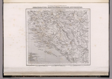
Author
Hellert, J. J.
Full Title
Herzegovina, Montenegro, Albanie Superieure. Imprimee chez Thierry Freres, Paris. Grave par J. Schwaerzle. Atlas de l'Empire Ottoman, par J.J. Hellert. Planche IV. (to accompany) Nouvel atlas physique, politique, et historique de l'Empire Ottoman... 1844.
List No
13229.013
Note
Engraved map. Shows political boundaries, major cities and towns. Includes legend. Prime meridian is Ferro. Relief shown by hachures.
Author
Hellert, J. J.
Full Title
Albanie Supre, Roumilie, Servie, Bulgarie, Valachie. Imprimee chez Thierry Freres, Paris. Grave par J. Schwaerzle. Atlas de l'Empire Ottoman, par J.J. Hellert. Planche V. (to accompany) Nouvel atlas physique, politique, et historique de l'Empire Ottoman... 1844.
List No
13229.014
Note
Engraved map. Shows political boundaries, major cities and towns. Includes legend. Prime meridian is Ferro. Relief shown by hachures.
Author
Hellert, J. J.
Full Title
Grece, Albanie et Thessalie. Grave par A. Benitz. Imprimee chez Thierry Freres, Paris. Atlas de l'Empire Ottoman, par J.J. Hellert. Planche VI. (to accompany) Nouvel atlas physique, politique, et historique de l'Empire Ottoman... 1844.
List No
13229.015
Note
Engraved map. Shows political boundaries, major cities and towns. Includes legend. Prime meridian is Ferro. Relief shown by hachures.
Author
Hellert, J. J.
Full Title
Siege de Scutari par Mohammed II : Du 8 Juin au 18 Sepbre. 1478. Grave par Ch. Schreiber. Imprime chez Thierry Freres. Atlas de l'Empire Ottoman, par J.J. Hellert. Planche XXXIII. (to accompany) Nouvel atlas physique, politique, et historique de l'Empire Ottoman... 1844.
List No
13229.042
Note
Engraved plan of the Siege of Shkodra. Showing the areas of the conflict. Includes explanation. Map showing fortifications, roads and rivers. Relief shown by hachures and form lines.
1-8 of 8
|