|
Author
Lloyd, J. T.
Full Title
Lloyd's official map of the state of Tennessee. Compiled from actual surveys and official documents, showing every rail road & rail road station with the distances between each station ... 1863. New York, J.T. Lloyd, Publisher, 164 Broadway. Price. 50 cents each, colored in sheets ... Entered ... 1862 by J.T. Lloyd ... N. York. (with) Eastern part of Tennessee.
List No
4817.001
Note
Entered in 1862. This was a companion map to Lloyd's Official Map of the State of Kentucky (our #4786) and issued from the same plate. If fact, almost all of Kentucky is shown on this map. Stephenson shows an edition of 1862, so this is the second edition. This copy backed with linen, as issued ("with linen backs for Army Officers $1.50"). The 1862 edition had battle sites underlined in red. Full color. Map is not dissected. Folds into pattered dark brown cloth covered boards 18.5x12 with ties. Battlefields not shown on this edition. Relief shown by hachures. Covers also most of Kentucky.
Author
Lloyd, J. T.
Full Title
(Covers to) Lloyd's official map of the state of Tennessee. Compiled from actual surveys and official documents, showing every rail road & rail road station with the distances between each station ... 1863. New York, J.T. Lloyd, Publisher, 164 Broadway. Price. 50 cents each, colored in sheets ... Entered ... 1862 by J.T. Lloyd ... N. York.
List No
4817A
Note
Pattered dark brown cloth covered boards 19 x 12 with ties.
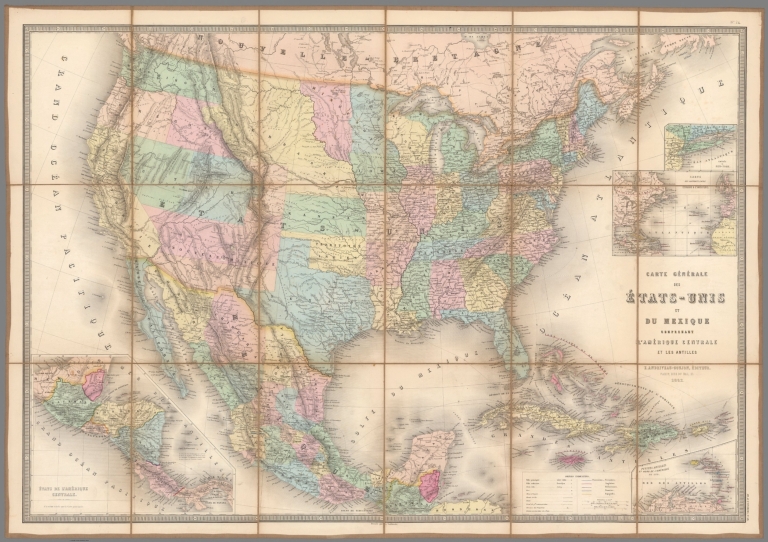
Author
Andriveau-Goujon, E.
Full Title
Carte Generale Des Etats - Unis Et Du Mexique Comprenant L'Amerique Centrale Et Les Antilles. E. Andriveau-Goujon, Editeur. Paris, Rue Du Bac, 21. 1862. Dressee par A. Vuillemin ... (with four inset maps).
List No
4598.002
Author
Bufford, J. H.
Full Title
War Map of the Middle States : Balloon View of Virginia, Maryland, Kentucky, Tennessee and parts of Arkansas, Missouri, Illinois, Indiana and Ohio. Boston, Lithographed and published by J.H. Bufford, 33, Washington Street. Paris & London. Published by Goupil & Co. New York. Pub: M. Knoedler, 772 Broadway.
List No
9868.000
Note
Colored rare bird’s-eye view of the theatre of conflict at the opening of the American Civil War. The view extends from Chesapeake Bay in the foreground to encompass the Appalachians and the watersheds of the Ohio and Mississippi Rivers. Shows topographical features, cities and towns, roads and railroads, and areas of elevation and waterways, in an unusual oblique view that captures a larger amount of landscape than appears in other Civil War views such as the Bachmanns (see our copies).. Relief shown by shadings. Tables in the left and right margins show distances by rail between Washington, D.C.; Cairo, Illinois; St. Louis, Missouri and other parts of the country. The map tracks the Mississippi as far south as Memphis. The whole is centered on Louisville Kentucky and the Ohio River Valley.
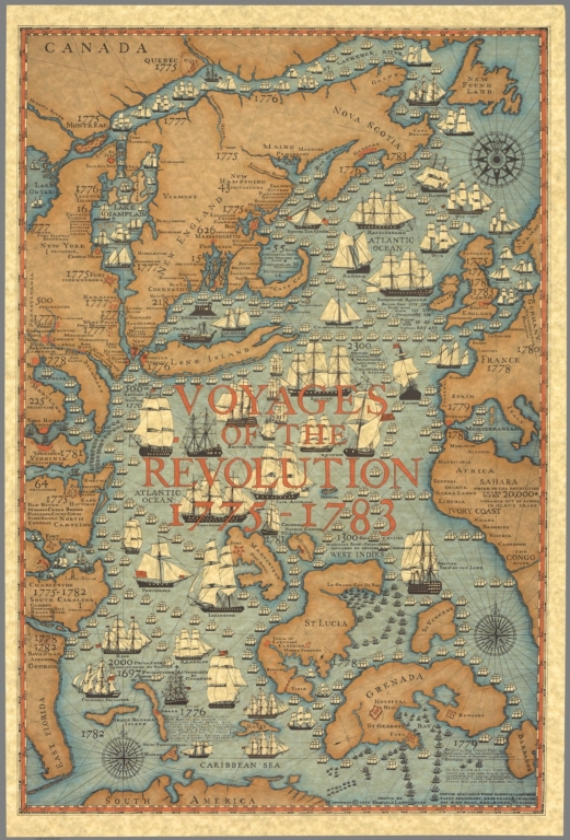
Author
Langworthy, Garfield
Full Title
Voyages of the Revolution 1775-1783. Drawn by Garfield Langworthy. Copyright 1975. From the Garfield Langworthy Yacht Chandlery, Brokerage & Charter on Bay Road, Shelbourne, Vermont.
List No
8424.000
Note
Pictorial map showing marine voyages and naval operations during the American Revolution. Includes towns, forts, naval bases, historical notes, and compass roses.
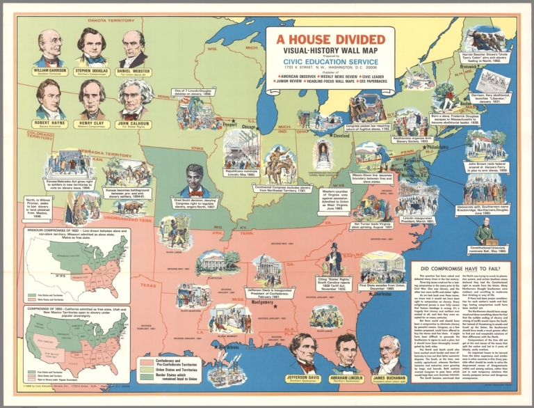
Civic Education Service, Inc.; Yaron, Al... A House divided : Visual - history wall ... 1966 8421.000 Related Author
[Civic Education Service, Inc., Yaron, Alexander]
Full Title
A House divided : Visual - history wall map. Civic Education Service. 1733 K. Street, N.W., Washington, D.C. 20006. Publisher of American Observer; Weekly News Review; Headline-Focus Wall Maps; CES paperbacks. Artist: Alexander Yaron. (insets) Missouri compromise of 1820. (with) Compromise of 1850.
List No
8421.000
Note
Pictorial map of the United States, covers the period leading up to the Civil War. Filled with vignettes of historical events and locations. Shows Confederacy ad Pro-Confederate Territories. Union States and Territories and border states which remained loyal to union. Includes portraits of important historical figures and text entitled: "Did compromise have to fail?".
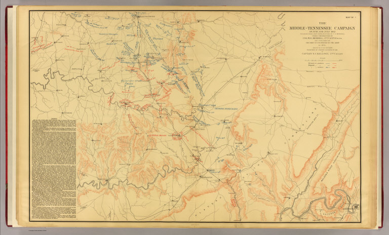
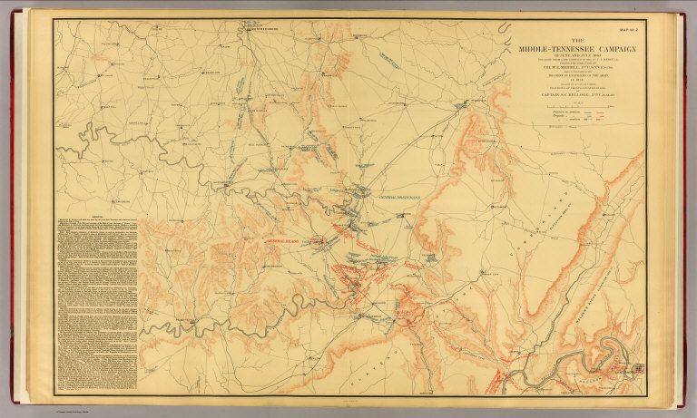
Author
[Kellogg, Sanford Cobb, 1842-, Mergell, C. S., United States. Army. Corps of Engineers]
Full Title
The Middle-Tennessee Campaign of June and July 1863, enlarged from a map compiled in 1865, by C.S. Mergell, under the direction of Col. W.E. Merrill, 1st U.S. V.V. Eng'rs, and published by the Chief of Engineers of the Army in 1874. Drawn by J. von Glumer. Positions of troops located in 1891 by Captain S.C. Kellogg, 5th Cavalry. Julius Bien & Co. lith. (Washington, D.C.: U.S. Government Printing Office, 1891)
List No
4249.001
Note
Col. lithographed map. Relief shown by hachures and spot heights. Includes lengthy note "Legend." Shows actions June 23-28.
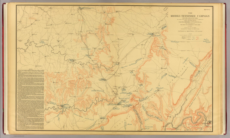
Author
[Kellogg, Sanford Cobb, 1842-, Mergell, C. S., United States. Army. Corps of Engineers]
Full Title
The Middle-Tennessee Campaign of June and July 1863, enlarged from a map compiled in 1865, by C.S. Mergell, under the direction of Col. W.E. Merrill, 1st U.S. V.V. Eng'rs, and published by the Chief of Engineers of the Army in 1874. Drawn by J. von Glumer. Positions of troops located in 1891 by Captain S.C. Kellogg, 5th Cavalry. Julius Bien & Co. lith. (Washington, D.C.: U.S. Government Printing Office, 1891)
List No
4249.002
Note
Col. lithographed map. Relief shown by hachures and spot heights. Includes lengthy note "Legend." Shows actions June 28-July 7th.
Author
[Kellogg, Sanford Cobb, 1842-, Mergell, C. S., United States. Army. Corps of Engineers]
Full Title
The Middle-Tennessee Campaign of June and July 1863, enlarged from a map compiled in 1865, by C.S. Mergell, under the direction of Col. W.E. Merrill, 1st U.S. V.V. Eng'rs, and published by the Chief of Engineers of the Army in 1874. Drawn by J. von Glumer. Positions of troops located in 1891 by Captain S.C. Kellogg, 5th Cavalry. Julius Bien & Co. lith. (Washington, D.C.: U.S. Government Printing Office, 1891)
List No
4249.003
Note
Col. lithographed map. Relief shown by hachures and spot heights. Includes lengthy note "Legend." Shows actions July 7-Aug. 19.
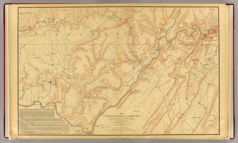
Author
[Kellogg, Sanford Cobb, 1842-, Mergell, C. S., United States. Army. Corps of Engineers]
Full Title
The Chattanooga Campaign of August and September 1863, enlarged from a map compiled in 1865, by C.S. Mergell, under the direction of Col. W.E. Merrill, 1st U.S. V.V. Eng'rs, and published by the Chief of Engineers of the Army in 1874. Drawn by J. von Glumer. Positions of troops located in 1891 by Captain S.C. Kellogg, 5th Cavalry. Julius Bien & Co. lith. (Washington, D.C.: U.S. Government Printing Office, 1891)
List No
4249.004
Note
Col. lithographed map. Relief shown by hachures and spot heights. Includes lengthy note "Legend." Shows actions July 15-Aug. 31.
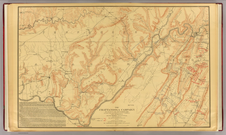
Author
[Kellogg, Sanford Cobb, 1842-, Mergell, C. S., United States. Army. Corps of Engineers]
Full Title
The Chattanooga Campaign of August and September 1863, enlarged from a map compiled in 1865, by C.S. Mergell, under the direction of Col. W.E. Merrill, 1st U.S. V.V. Eng'rs, and published by the Chief of Engineers of the Army in 1874. Drawn by J. von Glumer. Positions of troops located in 1891 by Captain S.C. Kellogg, 5th Cavalry. Julius Bien & Co. lith. (Washington, D.C.: U.S. Government Printing Office, 1891)
List No
4249.005
Note
Col. lithographed map. Relief shown by hachures and spot heights. Includes lengthy note "Legend." Shows actions Aug. 29-Sept. 17.
Author
[Kellogg, Sanford Cobb, 1842-, Mergell, C. S., United States. Army. Corps of Engineers]
Full Title
The Chattanooga Campaign of August and September 1863, enlarged from a map compiled in 1865, by C.S. Mergell, under the direction of Col. W.E. Merrill, 1st U.S. V.V. Eng'rs, and published by the Chief of Engineers of the Army in 1874. Drawn by J. von Glumer. Positions of troops located in 1891 by Captain S.C. Kellogg, 5th Cavalry. Julius Bien & Co. lith. (Washington, D.C.: U.S. Government Printing Office, 1891)
List No
4249.006
Note
Col. lithographed map. Relief shown by hachures and spot heights. Includes lengthy note "Legend." Shows actions Sept. 9-19.
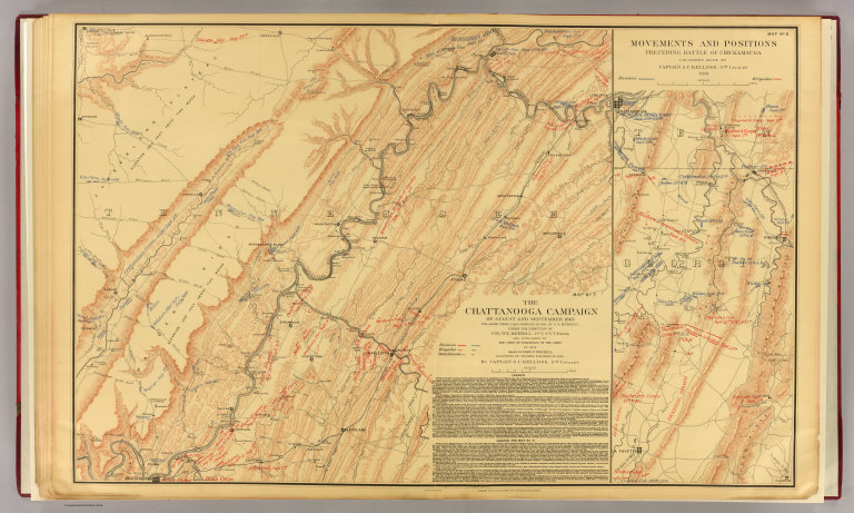
Kellogg, Sanford Cobb, 1842-; Mergell, C... Chattanooga, Chickamauga campaigns. 1891 4249.007 Related Author
[Kellogg, Sanford Cobb, 1842-, Mergell, C. S., United States. Army. Corps of Engineers]
Full Title
The Chattanooga Campaign of August and September 1863, enlarged from a map compiled in 1865, by C.S. Mergell, under the direction of Col. W.E. Merrill, 1st U.S. V.V. Eng'rs, and published by the Chief of Engineers of the Army in 1874. Drawn by J. von Glumer. Positions of troops located in 1891 by Captain S.C. Kellogg, 5th Cavalry. Movements and positions preceding Battle of Chickamauga, locations made by Captain S.C. Kellogg, 5th Cavalry, 1891. Julius Bien & Co. lith. (Washington, D.C.: U.S. Government Printing Office, 1891)
List No
4249.007
Note
Two col. lithographed maps on 1 sheet. Scale of "Movements and positions preceding Battle of Chickamauga ..." (ca. 1:82,000), covering W 85o 20'--W 85o05'/N 35o10'--N 34o40'). Relief shown by hachures and spot heights. Includes lengthy note "Legend." In margin: Errata * In last line of legend for westward read eastward. Shows actions July 10-Sept. 13.
United States. Army. Corps of Engineers Cover: Middle Tennessee, Chattanooga Cam... 1891 4249A Related Author
United States. Army. Corps of Engineers
Full Title
(Covers to) The Middle Tennessee and Chattanooga Campaigns of June, July, August and September 1863. (Chief of Engineers of the Army. Washington, D.C.: U.S. Government Printing Office, 1891)
List No
4249A
Note
All eight maps are derived and enlarged from an 1865 "Military Map of Middle Tennessee and parts of East Tennessee..." by C.S. Mergell (LC Civil War maps, 393) which was published in 1874. Each map says "Positions of the Troops located in 1891." Covers are half leather, red cloth covered boards with label reading "The Middle Tennessee and Chattanooga Campaign of 1863 including the Battle of Chickamauga." These maps are of great interest to historians of these battles because the level of detail regarding troop positions, etc. is very good. With printed color. Maps printed by Julius Bien & Co.
United States. Army. Corps of Engineers Title Page: Middle Tennessee, Chattanoog... 1891 4249B Related Author
United States. Army. Corps of Engineers
Full Title
(Title Page to) The Middle Tennessee and Chattanooga Campaigns of June, July, August and September 1863. (Chief of Engineers of the Army. Washington, D.C.: U.S. Government Printing Office, 1891)
List No
4249B
Note
All eight maps are derived and enlarged from an 1865 "Military Map of Middle Tennessee and parts of East Tennessee..." by C.S. Mergell (LC Civil War maps, 393) which was published in 1874. Each map says "Positions of the Troops located in 1891." Covers are half leather, red cloth covered boards with label reading "The Middle Tennessee and Chattanooga Campaign of 1863 including the Battle of Chickamauga." These maps are of great interest to historians of these battles because the level of detail regarding troop positions, etc. is very good. With printed color. Maps printed by Julius Bien & Co.
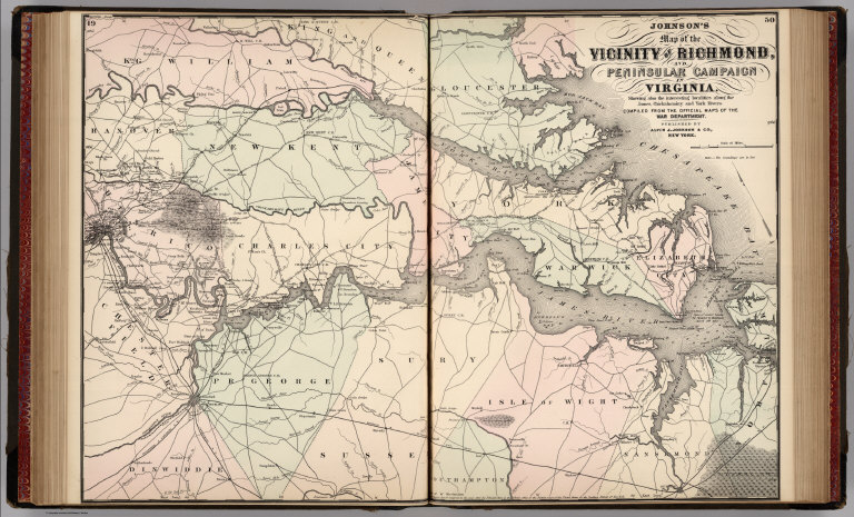
Author
Johnson, A.J.
Full Title
Johnson's Map of the Vicinity of Richmond and Peninsular Campaign in Virginia. Showing also the interesting localities along the James, Chickahominy and York Rivers. Compiled from the Official Maps of the War Department. Published by Alvin J. Johnson & Co., New York. 49. 50. Entered according to the Act of Congress, in the year 1862, by A.J. Johnson in the Clerk's Office of the District Court of the United States for the Southern District of New York.
List No
4828.037
Note
Engraved color map with districts differentiated by color. Shows roads and railroads. Includes information on troop movements in early portion of Civil War.
Weekly Dispatch; Ettling, Theodor, 1823- United States of North America (eastern ... 1863 14360.233 Related Author
[Weekly Dispatch, Ettling, Theodor, 1823-]
Full Title
United States of North America (eastern & central) : (West sheet) (East sheet). / by T. Ettling ; drawn & engraved by T. Ettling, 3, Red Lion Square Holborn.
List No
14360.233
Note
Map of the United States (west and east sheets). Shows political boundaries, cities, railways, roads, topography, bodies of water, drainage, coastlines, islands and the territories of indigenous peoples. Delineates between Federal, Border and Confederate States. Relief shown with hachures. Includes latitudinal and longitudinal lines, as well as a legend and two bar scales given in British and geographical miles. Hand-colored lithograph. Map is 42 x 64 cm, on two sheets, together 48 x 69 cm. Sheets presented in sequence. Appears in Vol. II : Foreign.
Weekly Dispatch; Ettling, Theodor, 1823- Composite Map: United States of North Am... 1863 14360.234 Related Author
[Weekly Dispatch, Ettling, Theodor, 1823-]
Full Title
(Composite Map to) United States of North America (eastern & central) : (West sheet) -- (East sheet) / by T. Ettling ; drawn & engraved by T. Ettling, 3, Red Lion Square Holborn.
List No
14360.234
Note
Composite map of the United States (west and east sheets). Shows political boundaries, cities, railways, roads, topography, bodies of water, drainage, coastlines, islands and the territories of indigenous peoples. Delineates between Federal, Border and Confederate States. Relief shown with hachures. Includes latitudinal and longitudinal lines, as well as a legend and two bar scales given in British and geographical miles. Hand-colored lithograph. Map is 42 x 64 cm, on two sheets, together 48 x 69 cm. Sheets presented in sequence. Appears in Vol. II : Foreign.
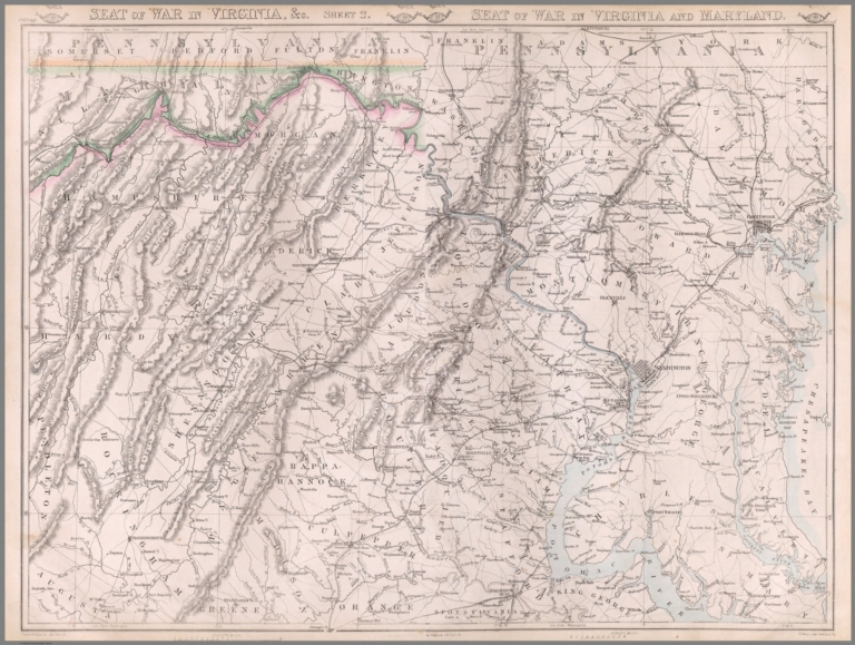
Weekly Dispatch; Weller, Edward, 1819-18... Seat of War in Virginia, &c. : Sheet 2. ... 1863 14360.255 Related Author
[Weekly Dispatch, Weller, Edward, 1819-1884]
Full Title
Seat of War in Virginia, &c. : Sheet 2 [Sheet 1]./ E. Weller, Lith. Red Lion Sq.
List No
14360.255
Note
Map of the "Seat of War" during the United States Civil War in Virginia, Maryland and Pennsylvania (sheet 2). Shows political boundaries, cities, railways, roads, topography, bodies of water and drainage. Relief shown with hachures. Includes latitudinal and longitudinal lines, as well as bar scales given in statute miles. Hand-colored lithograph. Map is 45 x 61 cm, on two sheets, together 48 x 69 cm. Followed by "Seat of War in Virginia : Sheet 3" on subsequent plate. Sheets presented in sequence. Appears in Vol. II : For
Weekly Dispatch; Weller, Edward, 1819-18... Composite Map: Seat of War in Virginia, ... 1863 14360.256 Related Author
[Weekly Dispatch, Weller, Edward, 1819-1884]
Full Title
(Composite Map to) Seat of War in Virginia, &c. : Sheet 2 -- Seat of War in Virginia and Maryland : [Sheet 1] / E. Weller, Lith. Red Lion Sq.
List No
14360.256
Note
Composite map of the "Seat of War" during the United States Civil War in Virginia, Maryland and Pennsylvania (sheet 2). Shows political boundaries, cities, railways, roads, topography, bodies of water and drainage. Relief shown with hachures. Includes latitudinal and longitudinal lines, as well as bar scales given in statute miles. Hand-colored lithograph. Map is 45 x 61 cm, on two sheets, together 48 x 69 cm. Followed by "Seat of War in Virginia : Sheet 3" on subsequent plate. Sheets presented in sequence. Appears in Vol. II : Foreign.
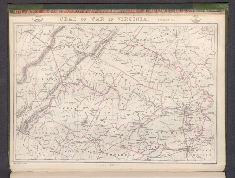
Weekly Dispatch; Weller, Edward, 1819-18... Seat of War in Virginia : Sheet 3. 1863 14360.257 Related Author
[Weekly Dispatch, Weller, Edward, 1819-1884]
Full Title
Seat of War in Virginia : Sheet 3 / E. Weller, Lith. Red Lion Square.
List No
14360.257
Note
Map of the "Seat of War" during the United States Civil War in Virginia (sheet 3). Shows political boundaries, cities, railways, roads, topography, bodies of water and drainage. Relief shown with hachures. Includes latitudinal and longitudinal lines, as well as a bar scale given in statute miles. Hand-colored lithograph. Map is 30 x 45 cm, on sheet 33 x 48 cm. Plate number handwritten in ink at upper and lower left corners of sheet. Preceded by maps entitled "Seat of War in Virginia, &c. : Sheet 2 -- Seat of War in Virginia and Maryland : [Sheet 1]" on previous plates. Appears in Vol. II : Foreign.
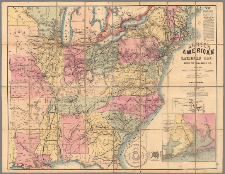
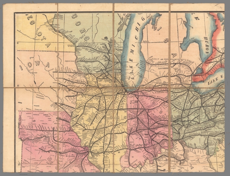
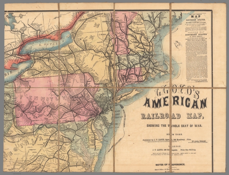
Author
Lloyd, James T.
Full Title
SW Sheet Lloyd's American Railroad Map, Showing the Whole Seat of War.
List No
10543.003
Author
Lloyd, James T.
Full Title
SE Sheet Lloyd's American Railroad Map, Showing the Whole Seat of War.
List No
10543.004
Author
Lloyd, James T.
Full Title
(Composite map of) NW, NE, SW, SE Sheets Lloyd's American Railroad Map, Showing the Whole Seat of War
List No
10543.005
Author
Lloyd, James T.
Full Title
NW Sheet Lloyd's American Railroad Map, Showing the Whole Seat of War.
List No
10543.001
Author
Lloyd, James T.
Full Title
NE Sheet Lloyd's American Railroad Map, Showing the Whole Seat of War.
List No
10543.002
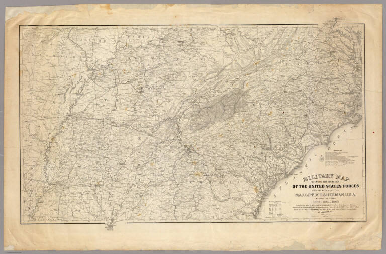
Jenney, W. L. B.; Kossak, William ; Mull... Military map showing the marches of the ... 1865 3876.000 Related Author
[Jenney, W. L. B., Kossak, William, Muller, John B., United States. Army. Military Division of the Mississippi]
Full Title
Military map showing the marches of the United States Forces under the command of Maj. Genl. W.T. Sherman, U.S.A. During the years 1863, 1864, 1865 ... Drawn by Capt. William Kossak ... and John B. Muller, draughtsman. St. Louis, Mo., 1865. Printed by Joseph F. Gedney. Engraved at Head Qrs., Corps of Engineers, U.S.A. by H.C. Evans & F. Courtenay.
List No
3876.000
Note
General map showing the entire South, with dark lines indicating the movement of Sherman's forces in Georgia and Tennessee. a list of authorities is given. Plate 117:1 in "Atlas to Accompany..." Without color.
Author
Lloyd, J. T.
Full Title
(Covers to) Lloyd's official map of the State of Virginia from actual surveys by order of the Executive 1828 & 1859. Corrected and revised by J.T. Lloyd to 1862, from surveys made by Capt. W. Angelo Powell, of the U.S. Topographical Engineers of Gen. Rosencrans' Staff. Price 25cts. ... J.T. Lloyd, Publisher, 164 Broadway, New York ... Entered ... 1861 by J.T. Lloyd ... New York.
List No
3814A
Note
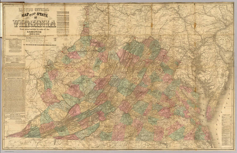
First issued in 1861, then 1862, and last issued in 1863. Taken from Boye's map of 1828 and extensively revised. Another issue of 1862 has a strange note regarding the Burnett House (a hotel) in Cincinnati. "This is the only map used to plan campaigns in Virginia by Gen. McClellan. The brown cloth covers 19x13 (with tie remnants) are titled in gold "Lloyd's $100,000 Topographical Map of Virginia. Used by the War Department." A promotional broadside was put out early in 1861 announcing the first issue of this map and calling it "the only real good map ever made in America" (see our copy with "Lloyd's Map of the Southern States" - Newspaper format). Full color by county. Map is mounted on linen and undissected. Covers also West Virginia.
Author
Lloyd, J. T.
Full Title
Lloyd's official map of the State of Virginia from actual surveys by order of the Executive 1828 & 1859. Corrected and revised by J.T. Lloyd to 1862, from surveys made by Capt. W. Angelo Powell, of the U.S. Topographical Engineers of Gen. Rosencrans' Staff. Price 25cts. ... J.T. Lloyd, Publisher, 164 Broadway, New York ... Entered ... 1861 by J.T. Lloyd ... New York.
List No
3814.001
Note
First issued in 1861, then 1862, and last issued in 1863. Taken from Boye's map of 1828 and extensively revised. Another issue of 1862 has a strange note regarding the Burnett House (a hotel) in Cincinnati. "This is the only map used to plan campaigns in Virginia by Gen. McClellan. The brown cloth covers 19x13 (with tie remnants) are titled in gold "Lloyd's $100,000 Topographical Map of Virginia. Used by the War Department." A promotional broadside was put out early in 1861 announcing the first issue of this map and calling it "the only real good map ever made in America" (see our copy with "Lloyd's Map of the Southern States" - Newspaper format). Full color by county. Map is mounted on linen and undissected. Covers also West Virginia.
Author
Packer, Thomas (1825 - 1896)
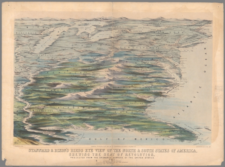
Full Title
Stannard & Dixon’s Birds Eye View of the North & South States of America, Shewing the Seat of Revolution, Projected from the Ordnance Surveys of the United States.
List No
15366.000
Note
Date estimated.
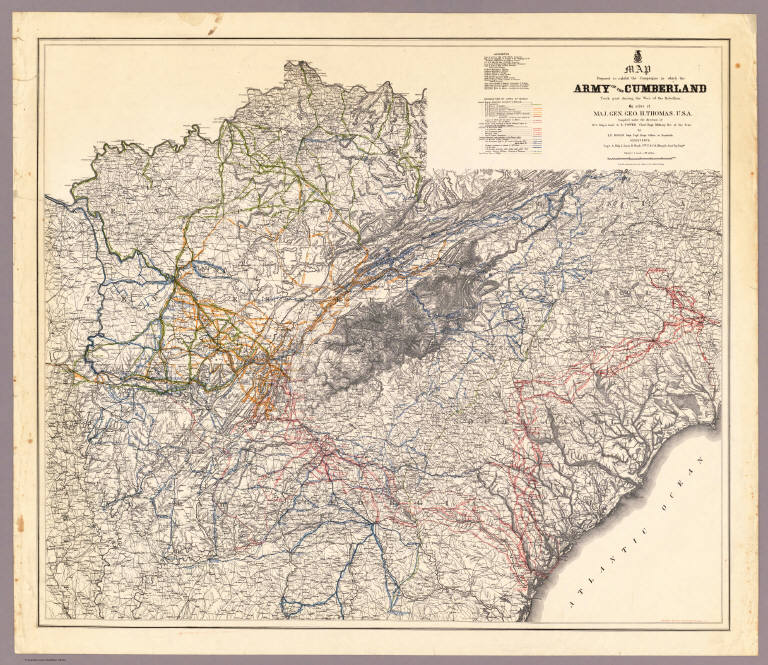
Author
Ruger, Edward
Full Title
Map Prepared to exhibit the Campaigns in which the Army Of The Cumberland Took part during the War of the Rebellion. By order of Maj. Genl. Geo. H. Thomas. U.S.A. Compiled under the direction of Bvt. Major Genl. Z.B. Tower Chief Engr. Military Div. of the Tenn. by Ed. Ruger, Supt. Topl. Engr. Office at Nashville. Assistants. Capt. A. Kilp & Lieut. R. Flach 3rd U.S.C.A. (Heavy) & Asst. Top. Engrs. ... Photolith. by the N.Y. Lithg. Engrg. & Prtg. Co. 16 & 18 Park Place.
List No
3852.000
Note
Very detailed map showing most of the southern states with the lines of march of the various Generals' campaigns shown in different colors. Date estimated. Plate 118:1 in "Atlas to Accompany..."
Bruff, J. Goldsborough ; Disturnell, Joh... Cover: Army map, Seat of War, Virginia. 1862 2846A Related Author
[Bruff, J. Goldsborough, Disturnell, John]
Full Title
(Covers to) Army Map Of The Seat Of War In Virginia, Showing the Battle Fields, Fortifications, Etc. on & near the Potomac River. Drawn by J.G. Bruff. Published by J. Disturnell, New York And Hudson Taylor, Washn. D.C. 1862. Entered ... 1861, by John Disturnell ... New York. Lith. of P.S. Duval & Son, Philada.
List No
2846A
Bruff, J. Goldsborough ; Disturnell, Joh... Army Map Of The Seat Of War In Virginia. 1862 2846.001 Related Author
[Bruff, J. Goldsborough, Disturnell, John]
Full Title
Army Map Of The Seat Of War In Virginia, Showing the Battle Fields, Fortifications, Etc. on & near the Potomac River. Drawn by J.G. Bruff. Published by J. Disturnell, New York And Hudson Taylor, Washn. D.C. 1862. Entered ... 1861, by John Disturnell ... New York. Lith. of P.S. Duval & Son, Philada.
List No
2846.001
Note
2nd edition, 1st was 1861. A beautiful production by Bruff, very detailed and well done. Major battles (Bull Run, etc.) near Washington are shown as well as fortifications around the capital. There is a list of 34 U.S. forts in the lower right. Map is folded into red cloth covers 15.5x11 with "Seat of War on the Potomac" stamped in gilt.
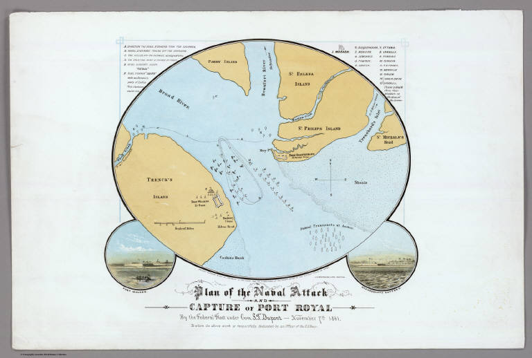
Author
Bufford, J.H.
Full Title
Plan of the Naval Attack And Capture of Port Royal By the Federal Fleet under Com. S.F. Dupont - November 7th, 1861. To whom the above work is respectfully dedicated by an Officer of the U.S. Navy. Entered ... 1862 by J.H. Bufford ... Mass.
List No
5192.000
Note
This exquisite map of Port Royal Sound with two small views of Forts Walker and Beauregard is not in Stephenson or any references. It shows the famous naval battle of November 7, 1861 and the capture of Forts Walker and Beauregard by Union forces. It is printed in color lithography. It is copyrighted in 1862 by J.H. Bufford, but the title indicates it was drawn by "an Officer of the U.S. Navy." Scarce.
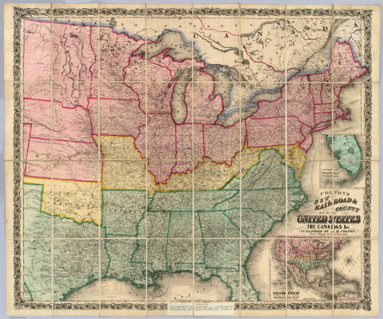
Author
Colton, J. H.
Full Title
(Covers to) Colton's New Railroad & County Map Of The United States, The Canadas &c. Published By J.H. Colton, No. 172 William St., New York 1862. Entered ... 1861 by J.H. Colton ... New York. (inset) Colton's Map of the United States Showing the Proposed Railroad Routes To The Pacific Ocean. (inset) Southern Part Of Florida.
List No
3358A
Author
Colton, J. H.
Full Title
Colton's New Railroad & County Map Of The United States, The Canadas &c. Published By J.H. Colton, No. 172 William St., New York 1862. Entered ... 1861 by J.H. Colton ... New York. (inset) Colton's Map of the United States Showing the Proposed Railroad Routes To The Pacific Ocean. (inset) Southern Part Of Florida.
List No
3358.001
Note
Civil War map - Confederacy green, North red, border states yellow. A pasted down sheet in the bottom margin explains the color coding and gives population statistics for the three regions. There is an ad for "Colton's...Complete Series of War Maps" on the verso of the cover and a pasted down list of Union and Confederate Political and Military leaders on the verso of the map. The map was sold in London by Sampson Low, Son & Co., by arrangement with Colton. All the prices quoted for Colton's maps on the paste down are in pounds. There was great demand in England for maps of the American Civil War, and Colton exploited it by providing his maps to English map sellers. W.H. has an identical copy of this map sold by Crutchly. Stanford also sold this map under his imprint. Full color. Dissected into 32 sections. Folds into dark green cloth covers 23x14.5 with a green paper label reading "Colton's Map Of Thr (sic) The United States Of America And The Canadas."
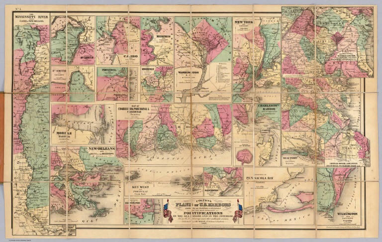
Author
Colton, J. H.
Full Title
(Covers to) Colton's Plans Of U.S. Harbors Showing The Position & Vicinities Of The Most Important Fortifications On The Sea-Board And In The Interior. From U.S. Surveys and other authentic sources. Published by J.H. Colton, 172 William St. New York. 1862. Entered ... 1860, by J.H. Colton ... New York. Printed by Lang & Laing 117 Fulton St. New York.
List No
3813A
Author
Colton, J. H.
Full Title
Colton's Plans Of U.S. Harbors Showing The Position & Vicinities Of The Most Important Fortifications On The Sea-Board And In The Interior. From U.S. Surveys and other authentic sources. Published by J.H. Colton, 172 William St. New York. 1862. Entered ... 1860, by J.H. Colton ... New York. Printed by Lang & Laing 117 Fulton St. New York.
List No
3813.001
Note
23 maps on one sheet. Bacon & Co. published Colton's maps in London during the Civil War. There is a catalogue of Bacon/Colton map on the inside cover of this map. Full color. Dissected into 18 sections. Folds into brown cloth covers 20x14 with blue paper label reading "Colton's Plans of the American Harbors, Showing the Positions of The Most Important Fortifications." Scarce.
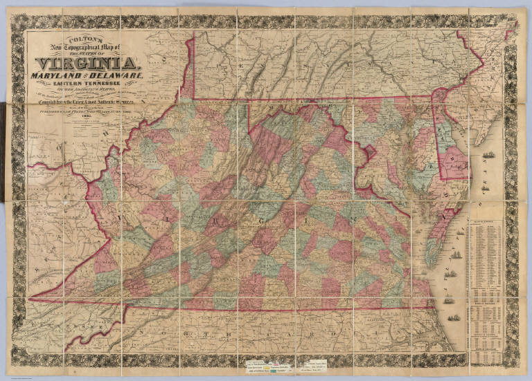
Author
Colton, J. H.
Full Title
(Covers to) Colton's New Topographical Map of The States Of Virginia, Maryland and Delaware, Showing Also Eastern Tennessee & Parts Of Other Adjoining States, All the Fortifications, Military Stations, Rail Roads, Common Roads and other Internal Improvements Compiled from the Latest & most Authentic Sources, On A Scale of 12 Miles to the Inch. Published By J.H. Colton, No. 172 William St. New York. Entered ... 1862, by J.H. Colton ... New York. Printed by Lang & Laing Lith 117 Fulton St. New York.
List No
4856A
Author
Colton, J. H.
Full Title
Colton's New Topographical Map of The States Of Virginia, Maryland and Delaware, Showing Also Eastern Tennessee & Parts Of Other Adjoining States, All the Fortifications, Military Stations, Rail Roads, Common Roads and other Internal Improvements Compiled from the Latest & most Authentic Sources, On A Scale of 12 Miles to the Inch. Published By J.H. Colton, No. 172 William St. New York. Entered ... 1862, by J.H. Colton ... New York. Printed by Lang & Laing Lith 117 Fulton St. New York.
List No
4856.001
Note
The second 1862 issue with added towns (Fair Oaks, etc.) around Richmond. This copy issued in London by Bacon and Co. with the following on the paste down: "Bacon's Shilling Series of American War Maps... the series affording all the information required for tracing the movements of the armies." Full color by county. Dissected into 36 sections. Map folds into brown cloth covers 23x14.5 with a green paper label reading "Colton's Steel Plate Map Of The State Of Virginia, On The Largest Scale Ever Published, Minutely Delineating Every Fort, Town, Railway, And Stream, In The State. Price folded in Case 6s. In Cloth Case 10s. On Rollers Varnished 12s. 6d."
Author
Colton, J. H.
Full Title
Colton's New Topographical Map Of The Eastern Portion Of The State Of North Carolina With Part Of Virginia & South Carolina From The Latest & Best Authorities. Published by J.H. Colton, No. 172 William St. N.Y. 1863. Entered ... 1860 by J.H. Colton ... New York. Printed by Lang & Cooper, 117 Fulton St. N.Y. (inset) Plan Of The Sea Coast From Virginia To Florida.
List No
3044.000
Note
1st issued 1861. Last issue 1864. With an inset "Plan of the Sea Coast From Virginia to Florida." This map is a companion map to Colton's Topographical Map of the Seat of War in Virginia, Maryland, &c. (see our copy), but on a larger scale (8 miles to an inch vs. 12 miles). It is both highly detailed (railroads, physical features, towns, counties, etc.) and highly decorative (many ships illustrated off the coasts). Map has outline color by state and water painted in blue; inset has full color by state.
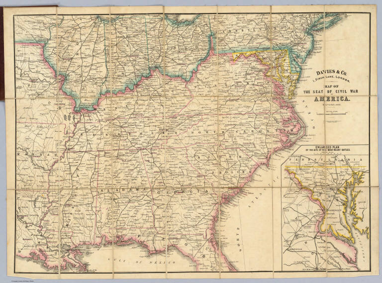
Author
Davies & Co.
Full Title
(Covers to) Map Of The Seat Of Civil War In America. October, 1862. Davies & Co. 1, Finch Lane, London. Maclure, Macdonald & Macgregor, 37, Walbrook, London, Lithographers by Steam Power. (inset) Enlarged Plan Of The Site Of The Most Recent Battles.
List No
4426A
Author
Davies & Co.
Full Title
Map Of The Seat Of Civil War In America. October, 1862. Davies & Co. 1, Finch Lane, London. Maclure, Macdonald & Macgregor, 37, Walbrook, London, Lithographers by Steam Power. (inset) Enlarged Plan Of The Site Of The Most Recent Battles.
List No
4426.001
Note
Not in Stephenson. Shows the Southern States west to eastern Missouri and Kansas, with an inset map titled "Enlarged Plan Of The Site Of The Most Recent Battles," which shows the area between Richmond and Baltimore. Many cities and towns are underlined in red, indicating a battle site or important military concentrations. Map is dissected into 21 sections and backed with linen folding into burgundy cloth covers 20x12 with Edward Stanford's printed label reading "Map Of The Seat Of War In America. London: Edward Stanford, 6, Charing Cross, S.W. 1862." Outline color by state, with the South in pink, North in blue, and Maryland in yellow. Scarce.
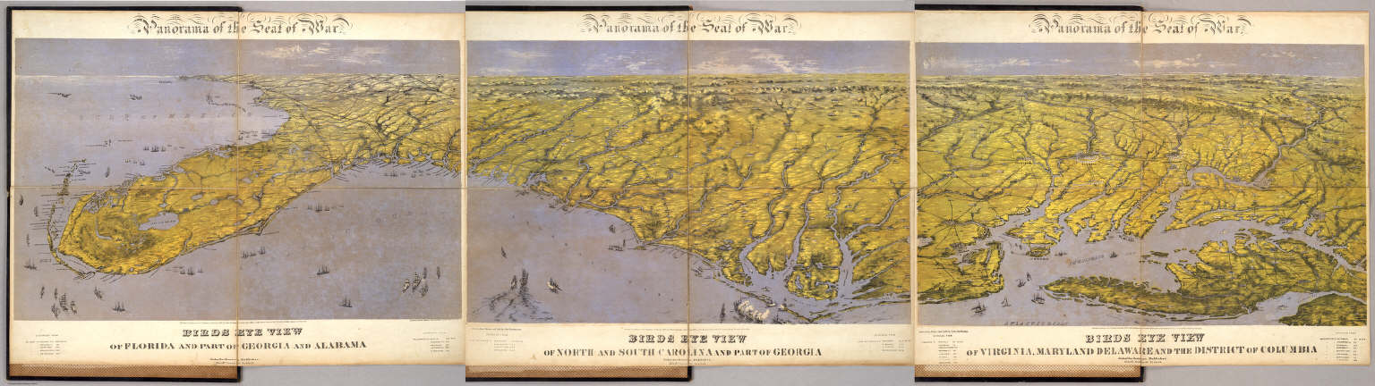
Author
Bachmann, John
Full Title
(Composite of) Panorama of the Seat of War. Birds eye view of Florida and part of Georgia and Alabama .. North and South Carolina and part of Georgia .. Virginia, Maryland, Delaware and the District of Columbia. John Bachmann, Publisher, 115 & 117 Nassau St., New York. Entered ... 1861 by John Bachmann ... New York. Drawn from Nature and Lith. by John Bachmann.
List No
5491.000
Note
Composite map image from three separate issues.
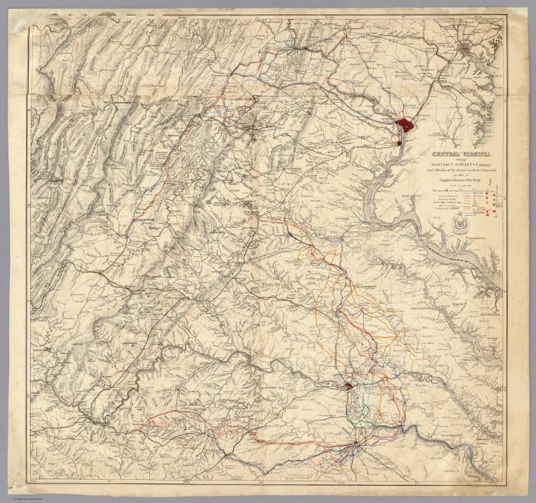
United States. War Dept. Engineer Bureau Central Virginia showing Lieut Gen'l U.S... 1865 3854.000 Related Author
United States. War Dept. Engineer Bureau
Full Title
Central Virginia showing Lieut Gen'l U.S. Grant's Campaign and Marches of the Armies under his Command in 1864-5. Engineer Bureau War Dept. Prepared by Order of the Secretary of War For the Officers of the U.S. Army under the command of Lieut. Gen. U.S. Grant.
List No
3854.000
Note
Extremely detailed map of central Virginia showing the routes of Grant's various armies in various colors. This version adds to sheets at the top to the original version (Stephenson 513). Plate 100:1 in "Atlas to Accompany..."
United States. War Dept. Engineer Bureau Region embraced in the Operations of the... 1865 3875.000 Related Author
United States. War Dept. Engineer Bureau
Full Title
Region embraced in the Operations of the Armies against Richmond and Petersburg. Engraved at the Engineer Bureau, War Dep. 1865. Authorities. North of James & Appomattox from Photograph Map Captured from the Enemy and Surveys of Maj. P.S. Michie Corps Of Engineers. South of Do. from Surveys of Col. N. Michler Corps Of Engineers.
List No
3875.000
Note
Detailed map of the area between Richmond and Petersburg, showing the street patterns of both cities. Differs from the Stephenson 644 in not having the 39th Cong. 1st Session printed on it. A very elegant map. Two sheets joined; map without color. Plate 100:2 in "Atlas to Accompany..."
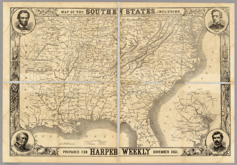
Author
Harper's Weekly
Full Title
Map Of The Southern States, Including Rail Roads, County Towns, State Capitals, County Roads, The Southern Coast ... To Texas, Showing The Harbors, Inlets, Forts And Position Of Blockading Ships. Prepared For Harper's Weekly November 1861. (untitled inset map of Washington D.C. and vicinity).
List No
5309.001
Note
Without color. The map is surrounded by a patriotic border with drawings of Lincoln, Seward, Scott, and M'Clellan in the corners. On the reverse are numerous drawings including: the Army at Edwards's Ferry, the fleet at the mouth of the Mississippi, and the valley of Shenandoah.
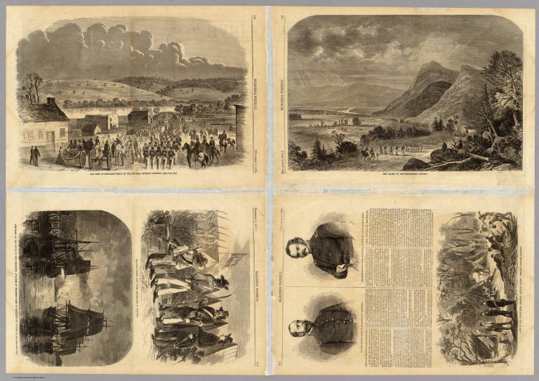
Author
Harper's Weekly
Full Title
(Text Page to) Map Of The Southern States, Including Rail Roads, County Towns, State Capitals, County Roads, The Southern Coast ... To Texas, Showing The Harbors, Inlets, Forts And Position Of Blockading Ships. Prepared For Harper's Weekly November 1861. (untitled inset map of Washington D.C. and vicinity).
List No
5309A
Note
The reverse side of the Harper's Weekly map. There are numerous drawings including: the Army at Edwards's Ferry, the fleet at the mouth of the Mississippi, and the valley of Shenandoah. Drawings without color.
Author
[Stanford, Edward, W. & A.K. Johnston Limited]
Full Title
(Covers to) United States. W. & A.K. Johnston, Edinburgh. (inset) Plan Of Charleston, Vicinity And Harbour.
List No
3236A
Author
[Stanford, Edward, W. & A.K. Johnston Limited]
Full Title
United States. W. & A.K. Johnston, Edinburgh. (inset) Plan Of Charleston, Vicinity And Harbour.
List No
3236.001
Note
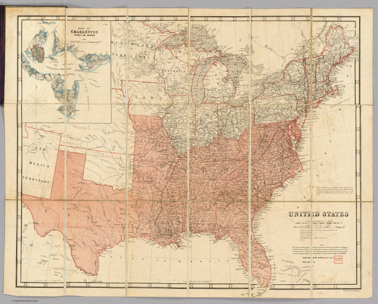
Separate issue of Johnston's National Atlas Map of the United States. Rare variant issue of this map: it has an inset of Charleston Vicinity and Harbor that does not appear on any other issues of the maps, and most importantly, the southern slave states and northern free states are color coded (solid red for slave and outline red for free). Two printed notes relate to the boundaries of the slave states and the cotton growing regions. The three forts at the entrance to Charleston Harbor are underlined in red. Although the presence of Minnesota Territory would indicate a date no later than 1858 (when it became a state), this map has much Civil War information and, in typical British fashion, it is probably a bit out of date as to political information, so we date it at the beginning of the war, 1861. Not in Stephenson. Map is dissected into 18 sections and mounted on linen with dark purple cloth covers 18.5x12 of Edward Stanford's map establishment, labeled with "Map Of The United States. London: Edward Stanford, 6, Charing Cross, S.W."
|


![Seat of War in Virginia, &c. : Sheet 2. [Sheet 1].](https://media.davidrumsey.com/MediaManager/srvr?mediafile=/Size3/RUMSEY~8~1/199/14360255.jpg)