|
Author
Polish Army Topography Service
Full Title
Agriculture (continued). Pergamon World Atlas. Pergamon Press, Ltd. & P.W.N. Poland 1967. Sluzba Topograficzna W.P.
List No
0737.035
Note
Six agricultural maps: sucrose plants, oleaginous plants, fibros plants, viticulture and wine production, fruit growing, and stimulants and condiments.
Author
Polish Army Topography Service
Full Title
Agriculture (continued). Pergamon World Atlas. Pergamon Press, Ltd. & P.W.N. Poland 1967. Sluzba Topograficzna W.P.
List No
0737.036
Note
Six agricultural maps: tuberous plants, cattle, pigs, sheep and goats, draught and pack animals, and types of animal husbandry..
Author
Polish Army Topography Service
Full Title
Agriculture. Pergamon World Atlas. Pergamon Press, Ltd. & P.W.N. Poland 1967. Sluzba Topograficzna W.P.
List No
0737.037
Note
Three agricultural maps: forests, production of wood products, and fishing.
Author
Polish Army Topography Service
Full Title
Water Economics. Pergamon World Atlas. Pergamon Press, Ltd. & P.W.N. Poland 1967. Sluzba Topograficzna W.P.
List No
0737.038
Note
Shows water utilization for agriculture and power, and general water availability compared with aridity.
Author
Polish Army Topography Service
Full Title
Industry. Pergamon World Atlas. Pergamon Press, Ltd. & P.W.N. Poland 1967. Sluzba Topograficzna W.P.
List No
0737.039
Note
Six maps of industry: employment in industry and mining, electricity production, power production potential, solid fuel production, and petroleum, natural gas and refining capacity.
Author
Polish Army Topography Service
Full Title
Industry - Steel Production. Pergamon World Atlas. Pergamon Press, Ltd. & P.W.N. Poland 1967. Sluzba Topograficzna W.P.
List No
0737.040
Note
Shows steel production per capita and overall output of various metals. Includes main movements of iron ore.
Author
Polish Army Topography Service
Full Title
Industry. Pergamon World Atlas. Pergamon Press, Ltd. & P.W.N. Poland 1967. Sluzba Topograficzna W.P.
List No
0737.041
Note
Three maps with insets of Europe show industrial production of: titanium, bauxite and aluminum; copper, tin and cadmium; and zinc and lead.
Author
Polish Army Topography Service
Full Title
Industry (continued). Pergamon World Atlas. Pergamon Press, Ltd. & P.W.N. Poland 1967. Sluzba Topograficzna W.P.
List No
0737.042
Note
Has six maps: precious metals and mercury; beryl, collumbite-tantalite, selenium and zircon; diamonds, abrasive and insulating substances; natural and synthetic rubber and tires; sulpher, phosphastes, potash salts and saltpeter; supheric acid, nitrogenous fertilizers, caustic soda and plastics.
Author
Polish Army Topography Service
Full Title
Industry (continued). Pergamon World Atlas. Pergamon Press, Ltd. & P.W.N. Poland 1967. Sluzba Topograficzna W.P.
List No
0737.043
Note
Has three maps: cement; machine tools; and motor vehicles and ships launched.
Author
Polish Army Topography Service
Full Title
Surface Communications and Time Zones. Pergamon World Atlas. Pergamon Press, Ltd. & P.W.N. Poland 1967. Sluzba Topograficzna W.P.
List No
0737.044
Note
Shows transport by mode, quantities of materials handled by ports, and time zones.
Author
Polish Army Topography Service
Full Title
Air Communications. Telecommunications, Tourism. Pergamon World Atlas. Pergamon Press, Ltd. & P.W.N. Poland 1967. Sluzba Topograficzna W.P.
List No
0737.045
Note
Two maps showing air routes and volumes. Three maps showing: telecommunications; radio and television; and international tourism.
Author
Polish Army Topography Service
Full Title
Education, Food Supply. Pergamon World Atlas. Pergamon Press, Ltd. & P.W.N. Poland 1967. Sluzba Topograficzna W.P.
List No
0737.046
Note
Two maps show literacy rates and caloric sufficiency.
Author
Polish Army Topography Service
Full Title
National Income. Pergamon World Atlas. Pergamon Press, Ltd. & P.W.N. Poland 1967. Sluzba Topograficzna W.P.
List No
0737.047
Note
Two maps show income per capita, and growth of national income as an average annual percentage (1955-1965).
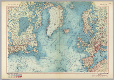
Author
Polish Army Topography Service
Full Title
North Atlantic. Pergamon World Atlas. Pergamon Press, Ltd. & P.W.N. Poland 1967. Sluzba Topograficzna W.P.
List No
0737.048
Note
Shows shipping lanes and distances, ports, bathymetry and topography.
Author
Polish Army Topography Service
Full Title
Atlantic Ocean. Antarctica. Pergamon World Atlas. Pergamon Press, Ltd. & P.W.N. Poland 1967. Sluzba Topograficzna W.P.
List No
0737.049
Note
Shows ocean currents, bathymetry, and topography. Antarctica map at 1:20,000,000 shows routes of scientific expeditions before 1957, bathymetry, topography, and ownership.
Author
Polish Army Topography Service
Full Title
The Arctic. Pergamon World Atlas. Pergamon Press, Ltd. & P.W.N. Poland 1967. Sluzba Topograficzna W.P.
List No
0737.050
Note
Shows routes of scientific expeditions before 1957, bathymetry, and topography.
Author
Polish Army Topography Service
Full Title
Atlantic Ocean. Atlantic Ocean - Islands. Pergamon World Atlas. Pergamon Press, Ltd. & P.W.N. Poland 1967. Sluzba Topograficzna W.P.
List No
0737.051
Note
Numerous small maps and diagrams of physical attributes of sea water by geographical distribution and depth. Also shows fishing grounds. Islands include Spitsbergen, Jan Mayan, Bear, Bermuda, Guadeloupe, Martinique, Madeira, Tenefrie, Gran Canaria, Canary Islands, Terceira, Sao Miguel, and Azores.
Author
Polish Army Topography Service
Full Title
Europe - Physical. Pergamon World Atlas. Pergamon Press, Ltd. & P.W.N. Poland 1967. Sluzba Topograficzna W.P.
List No
0737.052
Note
One large and three small maps. Topography and bathymetry in larger scale. Small maps of climate.
Author
Polish Army Topography Service
Full Title
Europe. Pergamon World Atlas. Pergamon Press, Ltd. & P.W.N. Poland 1967. Sluzba Topograficzna W.P.
List No
0737.053
Note
Four maps showing geology, geomorphology, soils, and vegetation.
Author
Polish Army Topography Service
Full Title
Europe. Pergamon World Atlas. Pergamon Press, Ltd. & P.W.N. Poland 1967. Sluzba Topograficzna W.P.
List No
0737.054
Note
Two maps showing mineral resources and land use.
Author
Polish Army Topography Service
Full Title
Europe. Pergamon World Atlas. Pergamon Press, Ltd. & P.W.N. Poland 1967. Sluzba Topograficzna W.P.
List No
0737.055
Note
Two maps showing communications including roads, seaport traffic, river port traffic, railways, inland waterways, train ferries, car ferries, and airport traffic.
Author
Polish Army Topography Service
Full Title
Western Europe. Pergamon World Atlas. Pergamon Press, Ltd. & P.W.N. Poland 1967. Sluzba Topograficzna W.P.
List No
0737.056
Note
Detailed physical and political map. Includes shipping lanes.
Author
Polish Army Topography Service
Full Title
Europe. Pergamon World Atlas. Pergamon Press, Ltd. & P.W.N. Poland 1967. Sluzba Topograficzna W.P.
List No
0737.057
Note
Five maps. Political Europe in 1914, 1937, and 1967; languages; and population density.
Author
Polish Army Topography Service
Full Title
Central Europe. Pergamon World Atlas. Pergamon Press, Ltd. & P.W.N. Poland 1967. Sluzba Topograficzna W.P.
List No
0737.058
Note
Detailed physical and political double-fold map.
Author
Polish Army Topography Service
Full Title
Poland. Pergamon World Atlas. Pergamon Press, Ltd. & P.W.N. Poland 1967. Sluzba Topograficzna W.P.
List No
0737.059
Note
Twenty small maps and graphs showing details about Poland including war damage 1939-1945, Polish migration 1945-1950, population density, other population attributes, employment, agriculture, climate, and land use.
Author
Polish Army Topography Service
Full Title
Poland North. Pergamon World Atlas. Pergamon Press, Ltd. & P.W.N. Poland 1964. Sluzba Topograficzna W.P.
List No
0737.060
Note
Detailed physical and political map.
Author
Polish Army Topography Service
Full Title
Poland. Pergamon World Atlas. Pergamon Press, Ltd. & P.W.N. Poland 1963. Sluzba Topograficzna W.P.
List No
0737.061
Note
Twenty three small maps and diagrams including mineral resources, power, chemicals, industrial production, port traffic, food and beverages, foreign trade, and wood products.
Author
Polish Army Topography Service
Full Title
Poland - South. (inset) Walbrzych. (inset) Upper Silesian Basin. Pergamon World Atlas. Pergamon Press, Ltd. & P.W.N. Poland 1967. Sluzba Topograficzna W.P.
List No
0737.062
Note
Detailed physical and political map.
Author
Polish Army Topography Service
Full Title
Poland. Pergamon World Atlas. Pergamon Press, Ltd. & P.W.N. Poland 1967. Sluzba Topograficzna W.P.
List No
0737.063
Note
Twenty urban vicinity maps of Polish cities: Warzawa, Lodz, Poznan, Bydgoszcz, Torun, Lublin, Radom, Wroclaw, Krakow, Szczecin, Gdansk-Gdynia, Koszaun, Kielce, Olsztyn, Kielce, Bialystok, Sudety, Zielona Gora, Opole, Rzeszow, and Czestochowa.
Author
Polish Army Topography Service
Full Title
Poland. Pergamon World Atlas. Pergamon Press, Ltd. & P.W.N. Poland 1967. Sluzba Topograficzna W.P.
List No
0737.064
Note
Four maps of Polish areas: Gdansk Coastal Area, Koszalin Coastal Area, Szczecin Lagoon, and Great Masurian Lakes.
Author
Polish Army Topography Service
Full Title
Poland. Pergamon World Atlas. Pergamon Press, Ltd. & P.W.N. Poland 1967. Sluzba Topograficzna W.P.
List No
0737.065
Note
Five maps of urban vicinity maps: Lubuskie Lakeland, Warsaw Region, Swietokrzyskie Mountains, Krakow Region, and Tatra Mountains.
Author
Polish Army Topography Service
Full Title
Czechoslovakia. Pergamon World Atlas. Pergamon Press, Ltd. & P.W.N. Poland 1964. Sluzba Topograficzna W.P.
List No
0737.066
Note
Eleven small maps and diagrams including population growth, crops, climate, land use, employment, population density, and livestock.
Author
Polish Army Topography Service
Full Title
Czechoslovakia. Pergamon World Atlas. Pergamon Press, Ltd. & P.W.N. Poland 1964. Sluzba Topograficzna W.P.
List No
0737.067
Note
Ten small maps and graphics including mineral and power resources, heavy industry, light industry, and foreign trade.
Author
Polish Army Topography Service
Full Title
Czechoslovakia. (inset) Brno. (inset) Ostrava. (inset) Praha (Prague). (inset) Bratislava. Pergamon World Atlas. Pergamon Press, Ltd. & P.W.N. Poland 1967. Sluzba Topograficzna W.P.
List No
0737.068
Note
Insets are vicinity maps. Detailed physical and political map.
Author
Polish Army Topography Service
Full Title
Czechoslovakia, German Democratic Republic. Pergamon World Atlas. Pergamon Press, Ltd. & P.W.N. Poland 1967. Sluzba Topograficzna W.P.
List No
0737.069
Note
Eight detailed maps of Erzgebirge, Elbe Gorge, Liberec Region, Berlin, Postock, Thuringia, Leipzig, and The Harz.
Author
Polish Army Topography Service
Full Title
Germany - North. Pergamon World Atlas. Pergamon Press, Ltd. & P.W.N. Poland 1964. Sluzba Topograficzna W.P.
List No
0737.070
Note
Detailed political and physical map.
Author
Polish Army Topography Service
Full Title
German Democratic Republic. Pergamon World Atlas. Pergamon Press, Ltd. & P.W.N. Poland 1964. Sluzba Topograficzna W.P.
List No
0737.071
Note
Twenty-seven small maps and graphics including population, industry, metallurgy, agriculture, and foreign trade.
Author
Polish Army Topography Service
Full Title
German Federal Republic. Pergamon World Atlas. Pergamon Press, Ltd. & P.W.N. Poland 1964. Sluzba Topograficzna W.P.
List No
0737.072
Note
Thirteen small maps and graphics including population density, population, relief, agriculture, livestock, and mineral resources.
Author
Polish Army Topography Service
Full Title
German Federal Republic. Pergamon World Atlas. Pergamon Press, Ltd. & P.W.N. Poland 1964. Sluzba Topograficzna W.P.
List No
0737.073
Note
Eleven small maps and graphics including industry, power resources, inland waterways, and foreign trade.
Author
Polish Army Topography Service
Full Title
Germany - South. (inset) Munchen (Munich). Pergamon World Atlas. Pergamon Press, Ltd. & P.W.N. Poland 1964. Sluzba Topograficzna W.P.
List No
0737.074
Note
Detailed political and physical map.
Author
Polish Army Topography Service
Full Title
German Federal Republic. (inset) Wilhelmshaven. Pergamon World Atlas. Pergamon Press, Ltd. & P.W.N. Poland 1964. Sluzba Topograficzna W.P.
List No
0737.075
Note
Three vicinity maps: Rhine Gorge, Hannover, and Ruhr Basin.
Author
Polish Army Topography Service
Full Title
Belgium, Netherlands, Luxembourg. Pergamon World Atlas. Pergamon Press, Ltd. & P.W.N. Poland 1964. Sluzba Topograficzna W.P.
List No
0737.076
Note
Includes ten small maps and graphics including relief types, coastal changes, cross-sections, population, agriculture, employment, and languages.
Author
Polish Army Topography Service
Full Title
Belgium, Netherlands, Luxembourg. Pergamon World Atlas. Pergamon Press, Ltd. & P.W.N. Poland 1964. Sluzba Topograficzna W.P.
List No
0737.077
Note
Includes eleven small maps and graphics including mineral resources, power, industry, transport traffic, movement of goods via ports and waterways, and foreign trade.
Author
Polish Army Topography Service
Full Title
Belgium, Luxembourg. Netherlands. Pergamon World Atlas. Pergamon Press, Ltd. & P.W.N. Poland 1964. Sluzba Topograficzna W.P.
List No
0737.078
Note
Two maps. Detailed political and physical features.
Author
Polish Army Topography Service
Full Title
Belgium, Netherlands. The Sound. Pergamon World Atlas. Pergamon Press, Ltd. & P.W.N. Poland 1964. Sluzba Topograficzna W.P.
List No
0737.079
Note
Six vicinity maps: Amsterdam, Arnheim-Nijmegen, Gravenhage,-Rotterdam, Bruxelles [Brussel] (Brussels), Antwerpen [Anvers] (Antwerp), and The Sound.
Author
Polish Army Topography Service
Full Title
Northern Europe. Pergamon World Atlas. Pergamon Press, Ltd. & P.W.N. Poland 1967. Sluzba Topograficzna W.P.
List No
0737.080
Note
Detailed political and physical map.
Author
Polish Army Topography Service
Full Title
Norway, Sweden, Finland. Pergamon World Atlas. Pergamon Press, Ltd. & P.W.N. Poland 1967. Sluzba Topograficzna W.P.
List No
0737.081
Note
Sixteen small maps and graphics including types of relief, population density, land use, population, agriculture, employment, mineral resources, power, forestry, industry, and foreign trade.
Author
Polish Army Topography Service
Full Title
Southern Scandanavia. Pergamon World Atlas. Pergamon Press, Ltd. & P.W.N. Poland 1964. Sluzba Topograficzna W.P.
List No
0737.082
Note
One large political and physical map, and ten small maps and graphics including types of relief, climate, population, employment, industry, agriculture, animal products, and foreign trade.
Author
Polish Army Topography Service
Full Title
Norway, Sweden, Finland, Iceland. Pergamon World Atlas. Pergamon Press, Ltd. & P.W.N. Poland 1964. Sluzba Topograficzna W.P.
List No
0737.083
Note
Large map of Iceland at 1:2,500,000. Seven maps of important locales: Bergen, Narvik Region, Stockholm, Nordkapp, Goteborg, Oslo, and Helsinki. Seven small maps and graphics pertaining to Iceland including fishing, population, agriculture, industry, employment, climate, and foreign trade.
Author
Polish Army Topography Service
Full Title
The British Isles. Pergamon World Atlas. Pergamon Press, Ltd. & P.W.N. Poland 1964. Sluzba Topograficzna W.P.
List No
0737.084
Note
Nine small maps and graphics including United Kingdom (worldwide), population, types of relief, climate, employment, sunshine, and population density.
|