|
Author
Polish Army Topography Service
Full Title
South East Europe, Selected Areas. Pergamon World Atlas. Pergamon Press, Ltd. & P.W.N. Poland 1964. Sluzba Topograficzna W.P.
List No
0737.113
Note
Five maps of urban vicinities or regions: Slovenian Karst Region, Lake Balaton, Wien (Vienna), Budapest, and Bulgaria's Black Sea Coast (Varna-Pomorie).
Author
Boucher, Lucien (1889-1971)
Full Title
(Sheet 1) Air France, Le Plus Grand Reseau du Monde. Perceval Paris Printed in France Ref: 22 - 183 /P/ 11-64.
List No
10284.001
Note
This is the scarce "blue" edition of Boucher's 8 sheet Air France world map. While generally the same design concept as the 1959 and 1961 "red" version (see our 10163.000), there are subtle differences throughout the map. At lower right border: Perceval Paris Printed in France Ref: 22 - 183 /P/ 11-64.
Author
Boucher, Lucien (1889-1971)
Full Title
(Sheet 2) Air France, Le Plus Grand Reseau du Monde. Perceval Paris Printed in France Ref: 22 - 183 /P/ 11-64.
List No
10284.002
Note
This is the scarce "blue" edition of Boucher's 8 sheet Air France world map. While generally the same design concept as the 1959 and 1961 "red" version (see our 10163.000), there are subtle differences throughout the map. At lower right border: Perceval Paris Printed in France Ref: 22 - 183 /P/ 11-64.
Author
Boucher, Lucien (1889-1971)
Full Title
(Sheet 3) Air France, Le Plus Grand Reseau du Monde. Perceval Paris Printed in France Ref: 22 - 183 /P/ 11-64.
List No
10284.003
Note
This is the scarce "blue" edition of Boucher's 8 sheet Air France world map. While generally the same design concept as the 1959 and 1961 "red" version (see our 10163.000), there are subtle differences throughout the map. At lower right border: Perceval Paris Printed in France Ref: 22 - 183 /P/ 11-64.
Author
Boucher, Lucien (1889-1971)
Full Title
(Sheet 4) Air France, Le Plus Grand Reseau du Monde. Perceval Paris Printed in France Ref: 22 - 183 /P/ 11-64.
List No
10284.004
Note
This is the scarce "blue" edition of Boucher's 8 sheet Air France world map. While generally the same design concept as the 1959 and 1961 "red" version (see our 10163.000), there are subtle differences throughout the map. At lower right border: Perceval Paris Printed in France Ref: 22 - 183 /P/ 11-64.
Author
Boucher, Lucien (1889-1971)
Full Title
(Sheet 5) Air France, Le Plus Grand Reseau du Monde. Perceval Paris Printed in France Ref: 22 - 183 /P/ 11-64.
List No
10284.005
Note
This is the scarce "blue" edition of Boucher's 8 sheet Air France world map. While generally the same design concept as the 1959 and 1961 "red" version (see our 10163.000), there are subtle differences throughout the map. At lower right border: Perceval Paris Printed in France Ref: 22 - 183 /P/ 11-64.
Author
Boucher, Lucien (1889-1971)
Full Title
(Sheet 6) Air France, Le Plus Grand Reseau du Monde. Perceval Paris Printed in France Ref: 22 - 183 /P/ 11-64.
List No
10284.006
Note
This is the scarce "blue" edition of Boucher's 8 sheet Air France world map. While generally the same design concept as the 1959 and 1961 "red" version (see our 10163.000), there are subtle differences throughout the map. At lower right border: Perceval Paris Printed in France Ref: 22 - 183 /P/ 11-64.
Author
Boucher, Lucien (1889-1971)
Full Title
(Sheet 7) Air France, Le Plus Grand Reseau du Monde. Perceval Paris Printed in France Ref: 22 - 183 /P/ 11-64.
List No
10284.007
Note
This is the scarce "blue" edition of Boucher's 8 sheet Air France world map. While generally the same design concept as the 1959 and 1961 "red" version (see our 10163.000), there are subtle differences throughout the map. At lower right border: Perceval Paris Printed in France Ref: 22 - 183 /P/ 11-64.
Author
Boucher, Lucien (1889-1971)
Full Title
(Sheet 8) Air France, Le Plus Grand Reseau du Monde. Perceval Paris Printed in France Ref: 22 - 183 /P/ 11-64.
List No
10284.008
Note
This is the scarce "blue" edition of Boucher's 8 sheet Air France world map. While generally the same design concept as the 1959 and 1961 "red" version (see our 10163.000), there are subtle differences throughout the map. At lower right border: Perceval Paris Printed in France Ref: 22 - 183 /P/ 11-64.
Author
Grimm, Berne C.
Full Title
Presidio of San Francisco and fort Winfield Scott. Copyright 1964, C. Berne Grimm, San Francisco, California.
List No
11063.000
Note
Detailed, full color pictorial map of the Presidio of San Francisco showing its history from 1776. shows points of interest, streets, forts, buildings, monuments, bus routes, beaches, notes on historical locations and events, recreational activities, parks, and decorative compass rose at upper right corner. Includes legend, text on history of Presidio, location map, indexes to points of interest, insignia of U.S. Coast Guard, Juan Bautista de Anza, U.S. Public Health Service, etc. Note: "Cleared for security before publication".
Author
Shacklett, Juanita Purvis
Full Title
(Covers to) Picture map of Africa. Printed in the United States of America. Copyright 1957 by Friendship Press, Inc. Revised 1964. Descriptive text by Juanita Purvis. copyright 1957 ... revised 1959.
List No
11263.001
Note
Uncolored pictorial map on sheet 127x96, as issued with sheet of descriptive text, and sheet of vignette images of life in Africa, folded to 30.5x23. Includes thirty three outline sketches of life in Africa. Map illustrating animals, landmarks, types of homes, churches, farms, means of travel, child life, village life, town life, mission activities, political boundaries and musical instruments. "This picture map is an exciting and valuable teaching tool for used with children". "A decorative map, which may be colored, together with an insert sheet containing informative notes and pictures to be cut out and pasted on the map."
Author
Shacklett, Juanita Purvis
Full Title
(Text Page to) Picture map of Africa. Printed in the United States of America. Copyright 1957 by Friendship Press, Inc. Revised 1964. Descriptive text by Juanita Purvis. copyright 1957 ... revised 1959.
List No
11263.002
Note
Uncolored pictorial map on sheet 127x96, as issued with sheet of descriptive text, and sheet of vignette images of life in Africa, folded to 30.5x23. Includes thirty three outline sketches of life in Africa. Map illustrating animals, landmarks, types of homes, churches, farms, means of travel, child life, village life, town life, mission activities, political boundaries and musical instruments. "This picture map is an exciting and valuable teaching tool for used with children". "A decorative map, which may be colored, together with an insert sheet containing informative notes and pictures to be cut out and pasted on the map."
Author
Shacklett, Juanita Purvis
Full Title
Picture map of Africa. Printed in the United States of America. Copyright 1957 by Friendship Press, Inc. Revised 1964. Descriptive text by Juanita Purvis. copyright 1957 ... revised 1959.
List No
11263.003
Note
Uncolored pictorial map on sheet 127x96, as issued with sheet of descriptive text, and sheet of vignette images of life in Africa, folded to 30.5x23. Includes thirty three outline sketches of life in Africa. Map illustrating animals, landmarks, types of homes, churches, farms, means of travel, child life, village life, town life, mission activities, political boundaries and musical instruments. "This picture map is an exciting and valuable teaching tool for used with children". "A decorative map, which may be colored, together with an insert sheet containing informative notes and pictures to be cut out and pasted on the map."
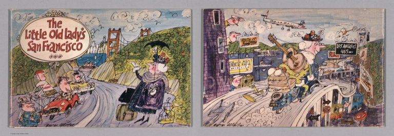
Author
[Shilling, Bill, Albertus, George]
Full Title
(Covers to) The Little Old Lady's San Francisco by Bill Shilling and George Albertus. Copyright 1964 ... Distributed by Maxcy & Associate ....
List No
12074.001
Author
[Shilling, Bill, Albertus, George]
Full Title
The Little Old Lady's Guide to San Francisco.
List No
12074.002
Author
[Shilling, Bill, Albertus, George]
Full Title
(Composite Text) The Little Old Lady's San Francisco by Bill Shilling and George Albertus. Copyright 1964 ... Distributed by Maxcy & Associate ....
List No
12074.003
Author
[Geological Survey (U.S.), Conant, Louis C., Goudarzi, Gus H.]
Full Title
(Covers to) Geologic map of the Kingdom of Libya = خريطة جيولوجية للمملكة الليبية = Kharīṭah jiyūlūjīyah lil-Mamlakah al-Lībyah. Compiled by Louis C. Conant and Gus H. Goudarzi under the joint sponsorship of the Kingdom of Libya and the Agency for International Development, U. S. Department of State. 1964. Department of Interior, United States Geological Survey. Kingdom of Libya. Ministries of National Economy, Petroleum Affairs, and Industry. Miscellaneous Geological Investigations, Map 1-350 A.
List No
13541.001
Author
[Geological Survey (U.S.), Dodd, A. V., United States. Environmental Data Service, United States. Environmental Science Services Administration]
Full Title
Mean monthly dew point temperature : January dew point -- April dew point -- July dew point -- October dew point / compiled by A. V. Dodd, U. S. Army from official hourly weather records for periods averaging 10 years in length prior to 1964 -- Mean monthly relative humidity : January relative humidity -- April relative humidity -- July relative humidity -- October relative humidity / adapted from 1:20,000,000-scale maps by Environmental Data Service, Environmental Science Services Administration records for the period 1931-1952 -- Mean annual number of days with snowfall one inch or more / compiled by Environmental Data Service, Environmental Science Services Administration for varying periods 20 years or more in length, prior to 1960.
List No
14359.074
Note
Eight physical maps representing the United States, featuring dew point and humidity in January, April, July and October, based upon the periods recorded prior to 1964. Maps also show political boundaries, bodies of water, drainage, coastlines and islands. Maps include legends, as well as bar scales and scale statements. Presented with Albers Equal Area Projection. With two inset maps within each map: Principal islands of Hawaii -- Alaska. Colored lithograph. Together, maps are 42 x 31 cm, on sheet 49 x 35 cm. Maps appear in Special subject maps section, subsection Physical : Climate.
Author
[Geological Survey (U.S.), United States. Bureau of Commercial Fisheries]
Full Title
Volume of commercial catch by use : 1964 -- Value of commercial catch by use : 1964 / compiled from information by U. S. Bureau of Commercial Fisheries, 1968.
List No
14359.110
Note
Two economic maps representing the United States, featuring commercial fishing, as of 1964. Maps show both the volume and value of commercial fishing catch (by use) in 1964, political boundaries, bodies of water, coastlines and islands. Maps include legends, as well as bar scales and scale statements. Presented with Albers Equal Area Projection. With two inset maps within each map: Principal islands of Hawaii -- Alaska. Colored lithograph. Maps are each 20 x 31 cm, on sheet 49 x 35 cm. Maps appear in Special subject maps section, subsection Economic : Fishing and forestry.
Author
[Geological Survey (U.S.), United States. Bureau of Commercial Fisheries]
Full Title
Fisherman and fishing craft : 1964 -- Volume of catch by gear : 1964 / compiled from information by U. S. Bureau of Commercial Fisheries, 1968.
List No
14359.111
Note
Two economic maps representing the United States, featuring commercial fishing, as of 1964. Maps show the number of fisherman and fishing craft, the volume of catch (by gear) in 1964, political boundaries, bodies of water, coastlines and islands. Maps include legends, as well as bar scales and scale statements. Presented with Albers Equal Area Projection. With two inset maps within each map: Principal islands of Hawaii -- Alaska. Colored lithograph. Maps are each 20 x 31 cm, on sheet 49 x 35 cm. Maps appear in Special subject maps section, subsection Economic : Fishing and forestry.
Author
[Geological Survey (U.S.), U.S. Census Bureau, United States. Conservation Needs Inventory Committee, United States. Department of Agriculture]
Full Title
Land in farms : 1964 -- Land in farms as a percent of total land area : 1964 -- Cropland : 1964 / compiled by U. S. Bureau of the Census, Census of agriculture: 1964, v. I, Washington, U. S. Govt. Print Off., 1967, county table 1 -- Cropland as a percent of total land area : 1964 -- Grazing and pastureland : 1959 -- Grazing and pastureland as a percent of total land area : 1959 / compiled from information provided by the Conservation Needs Inventory Committee, U. S. Dept. of Agriculture, 1967 -- Forest and woodland : 1959 -- Forest and woodland as a percent of total land area : 1959.
List No
14359.116
Note
Eight economic maps representing the United States, featuring the major uses of land - such as cropland, grazing and pastureland, and forest and woodland - as of 1964. Maps show the absolute figures for land use, as well as the percentage out of the total land area. Maps also show political boundaries, bodies of water, coastlines and islands. Maps include legends, as well as bar scales and scale statements. Presented with Albers Equal Area Projection. With two inset maps within each map: Principal islands of Hawaii -- Alaska. Colored lithograph. Together, maps are 42 x 31 cm, on sheet 49 x 35 cm. Accompanying descriptive text on page 157. Maps appear in Special subject maps section, subsection Economic : Agriculture.
Author
[Geological Survey (U.S.), U.S. Census Bureau]
Full Title
Full owners and part owners : 1964 / compiled from U. S. Bureau of the Census, Census of agriculture: 1964, v. I, Washington, U. S. Govt. Print Off., 1967, county table 4 and State table 3 -- Managers and tenants : 1964.
List No
14359.117
Note
Two economic maps representing the United States, featuring ownership of land, as of 1964. Maps show full and part ownership of farms, managers and tenants of farms, as well as political boundaries, bodies of water, coastlines and islands. Maps include legends, as well as bar scales and scale statements. Presented with Albers Equal Area Projection. With two inset maps within each map: Principal islands of Hawaii -- Alaska. Colored lithograph. Maps are each 20 x 31 cm, on sheet 49 x 35 cm. Maps appear in Special subject maps section, subsection Economic : Agriculture.
Author
[Geological Survey (U.S.), U.S. Census Bureau]
Full Title
Total farms : 1964 / compiled from U. S. Bureau of the Census, Census of agriculture: 1964, v. I, Washington, U. S. Govt. Print Off., 1967, county table 1 and State table 2 -- Farms of less than 50 acres : 1964 -- Farms of 50-179 acres : 1964 -- Farms of 180-259 acres : 1964 -- Farms of 260-499 acres : 1964 -- Farms of 500-999 acres : 1964 -- Farms of 260-499 acres : 1964 -- Farms of 1,000 acres or more : 1964 -- General farms : 1964 -- Livestock farms : 1964 -- Cash-grain farms : 1964 -- Dairy and poultry farms : 1964 -- Tobacco, cotton and other field crop farms : 1964 -- Vegetable and fruit and nut farms : 1964.
List No
14359.118
Note
Thirteen economic maps representing the United States, featuring farm sizes and types - such as livestock, field crops, fruits and vegetables - as of 1964. Maps show political boundaries, bodies of water, drainage, coastlines and islands. Maps include legends, as well as explanatory notes and scale statements (scales differ). With two inset maps within each map: Principal islands of Hawaii -- Alaska. Colored lithograph. Together, maps are 42 x 65 cm, on double sheet 49 x 71 cm. Maps appear in Special subject maps section, subsection Economic : Agriculture.
Author
[Geological Survey (U.S.), U.S. Census Bureau]
Full Title
Hired workers : 1964 / compiled from U. S. Bureau of the Census, Census of agriculture: 1964, v. I, Washington, U. S. Govt. Print Off., 1967, county table 8; Statistical Reporting Service, Farm labor, Washington, U. S. Dept. of Agric. March 1965, p. 4 and 6 -- Expenditures for hired labor on farms : 1964 / compiled from U. S. Bureau of the Census, Census of agriculture: 1964, v. I, Washington, U. S. Govt. Print Off., 1967, county table 9.
List No
14359.119
Note
Two economic maps representing the United States, featuring farm laborers and costs of labor, as of 1964. Maps show hired works as a percentage of total farm labor, as well as the expenditure for hired labor. Maps also show political boundaries, bodies of water, coastlines and islands. Maps include legends, as well as bar scales and scale statements. Presented with Albers Equal Area Projection. With two inset maps within each map: Principal islands of Hawaii -- Alaska. Colored lithograph. Maps are each 20 x 31 cm, on sheet 49 x 35 cm. Maps appear in Special subject maps section, subsection Economic : Agriculture.
Author
[Geological Survey (U.S.), U.S. Census Bureau]
Full Title
Total commercial farms : 1964 -- Class I farms : 1964 -- Class II farms : 1964 -- Class III farms : 1964 -- Class IV farms : 1964 -- Class V farms : 1964 -- Class VI farms : 1964 -- Part-time and part-retirement farms : 1964 / all maps compiled from U. S. Bureau of the Census, Census of agriculture: 1964, v. I, Washington, U. S. Govt. Print Off., 1967, county table 6 and State table 17.
List No
14359.120
Note
Eight economic maps representing the United States, featuring economic classes of farms, as of 1964. Maps show the total number of commercial farms, as well as Class I-VI farms, and part-time and part-retirement farms. Maps also show political boundaries, bodies of water, coastlines and islands. Maps include legends, as well as bar scales and scale statements. Presented with Albers Equal Area Projection. With two inset maps within each map: Principal islands of Hawaii -- Alaska. Colored lithograph. Together, maps are 42 x 31 cm, on sheet 49 x 35 cm. Maps appear in Special subject maps section, subsection Economic : Agriculture.
Author
[Geological Survey (U.S.), U.S. Census Bureau]
Full Title
Average value of land and buildings per farm : 1964 / compiled from U. S. Bureau of the Census, Census of agriculture: 1964, v. I, Washington, U. S. Govt. Print Off., 1967, county table 1 -- Expenditures for petroleum products : 1964 -- Expenditures for machine hire, custom and contract work : 1964 / compiled from U. S. Bureau of the Census, Census of agriculture: 1964, v. I, Washington, U. S. Govt. Print Off., 1967, county table 9 -- Expenditures for feed : 1964 -- Expenditures for fertilizers : 1964.
List No
14359.121
Note
Five economic maps representing the United States, featuring values of farms and their expenditures, as of 1964. Maps show values of both land and buildings, as well as expenditures for petroleum products, labor, machinery, feed and fertilizers. Maps also show political boundaries, bodies of water, coastlines and islands. Maps include legends, as well as bar scales and scale statements (scales differ). Presented with Albers Equal Area Projection. With two inset maps within each map: Principal islands of Hawaii -- Alaska. Colored lithograph. Together, maps are 42 x 31 cm, on sheet 49 x 35 cm. Maps appear in Special subject maps section, subsection Economic : Agriculture.
Author
[Geological Survey (U.S.), U.S. Census Bureau]
Full Title
Average commercially fertilized : 1964 / compiled from U. S. Bureau of the Census, Census of agriculture: 1964, v. I, Washington, U. S. Govt. Print Off., 1967, county table 9 and State table 1 -- Farm ponds : 1964 / compiled from U. S. Bureau of the Census, Census of agriculture: 1964, v. I, county table 1; v. II, chap. 9, table 14, Washington, U. S. Govt. Print Off., 1967 -- Acreage limed : 1964 / compiled from U. S. Bureau of the Census, Census of agriculture: 1964, v. I, Washington, U. S. Govt. Print Off., 1967, county table 9 and State table 1 -- Cropland farmed on the contour : 1964 / compiled from U. S. Bureau of the Census, Census of agriculture: 1964, v. I, county table 1; v. II, chap. 9, table 14, Washington, U. S. Govt. Print Off., 1967 -- Land in strip crops : 1964 / compiled from U. S. Bureau of the Census, Census of agriculture: 1964, v. I, county table 1; v. II, chap. 9, table 14, Washington, U. S. Govt. Print Off., 1967.
List No
14359.122
Note
Five economic maps representing the United States, featuring the use of farmland, as of 1964. Maps show acreage commercially fertilized, limed, farmed on the contour and in strip crops, as well as the percentage of farms with ponds. Maps also show political boundaries, bodies of water, coastlines and islands. Maps include legends, as well as bar scales and scale statements (scales differ). Presented with Albers Equal Area Projection. With two inset maps within each map: Principal islands of Hawaii -- Alaska. Colored lithograph. Together, maps are 42 x 31 cm, on sheet 49 x 35 cm. Maps appear in Special subject maps section, subsection Economic : Agriculture.
Author
[Geological Survey (U.S.), U.S. Census Bureau]
Full Title
Irrigated land in farms : 1964 / compiled from U. S. Bureau of the Census, Census of agriculture: 1964, v. I, Washington, U. S. Govt. Print Off., 1967, county tables 1 and 2, and State table 1 -- Agricultural land in drainage enterprises : 1959 / compiled from U. S. Bureau of the Census, Census of agriculture: 1959, v. IV, Washington, U. S. Govt. Print Off., 1961, county table 1.
List No
14359.123
Note
Two economic maps representing the United States, featuring water practices on farms, as of 1964. Maps show irrigation and drainage enterprises on agricultural land. Maps also show political boundaries, bodies of water, coastlines and islands. Maps include legends, as well as bar scales and scale statements. Presented with Albers Equal Area Projection. With two inset maps within each map: Principal islands of Hawaii -- Alaska. Colored lithograph. Maps are each 20 x 31 cm, on sheet 49 x 35 cm. Maps appear in Special subject maps section, subsection Economic : Agriculture.
Author
[Geological Survey (U.S.), U.S. Census Bureau, United States. Department of Agriculture. Statistical Reporting Service]
Full Title
Field crops sold : 1964 -- Livestock and products sold : 1964 -- Dairy products sold : 1964 -- Poultry and products sold : 1964 / the four maps above compiled from U. S. Bureau of the Census, Census of agriculture: 1964, v. I, Washington, U. S. Govt. Print Off., 1967, county table 6, and State table 17 -- Wheat harvested : 1964 / compiled from U. S. Bureau of the Census, Census of agriculture: 1964, v. I, county table 13, and v. II, chap. 4, table 16, Washington, U. S. Govt. Print Off., 1967; Statistical Reporting Service, Field crops, Stat. Bull. 384, Washington U. S. Dept. of Agriculture, 1966, table 1. (with) Barley harvested : 1964 / compiled by Census of agriculture: 1964, v. I, county table 13, v. II, chap. 4, table 25; Field crops, Stat. Bull. 384, tables 11 & 46 -- Cotton harvested : 1964 / compiled by Census of agriculture: 1964, v. I, county table 13; Field crops, Stat. Bull. 384, table 45 -- Sorghums and oats harvested : 1964 / compiled by Census of agriculture: 1964, v. I, county table 13, v. II, chap. 4, table 24; Field crops, Stat. Bull. 384, tables 10 & 46 -- Soybeans harvested : 1964 / compiled by Census of agriculture: 1964, v. I, county table 13, v. II, chap. 4, table 45; Field crops, Stat. Bull. 384, table 23 -- Corn harvested : 1964 / compiled by Census of agriculture: 1964, v. I, county table 13, and v. II, chap. 4, table 12, Washington, U. S. Govt. Print Off., 1967; Statistical Reporting Service, Field crops, Stat. Bull. 384, Washington U. S. Dept. of Agriculture, 1966, table 9.
List No
14359.125
Note
Ten economic maps representing the United States, featuring crops sold and harvested - such as wheat, barley, cotton and corn - as of 1964. Maps also show political boundaries, bodies of water, coastlines and islands. Maps include legends, as well as bar scales and scale statements (scales differ). Presented with Albers Equal Area Projection. With two inset maps within each map: Principal islands of Hawaii -- Alaska. Colored lithograph. Together, maps are 42 x 31 cm, on sheet 49 x 35 cm. Maps appear in Special subject maps section, subsection Economic : Agriculture.
Author
[Geological Survey (U.S.), U.S. Census Bureau, United States. Department of Agriculture. Statistical Reporting Service]
Full Title
Hay cut : 1964 / compiled by U. S. Bureau of the Census, Census of agriculture: 1964, v. I, county table 13, and v. II, chap. 4, table 35, Washington, U. S. Govt. Print Off., 1967 -- Peanuts, flax, and rice harvested : 1964 / compiled from Census of agriculture: 1964, v. I, county table 13 -- Tobacco, sugar cane, and sugar beets harvested : 1964 / compiled from Census of agriculture: 1964, v. I, county table 13 -- Irish and sweet potatoes harvested : 1964 / compiled from Census of agriculture: 1964, v. I, county table 13; Potatoes and sweet potatoes, Stat. Bull. 409, tables 16-20 & 27 -- Dry field and seed beans harvested : 1964 / compiled from Census of agriculture: 1964, v. I, county table 13; Field and seed crops, Stat. Bull. 404, table 14.
List No
14359.126
Note
Five economic maps representing the United States, featuring crops harvested - such as hay, rice and tobacco - as of 1964. Maps also show political boundaries, bodies of water, coastlines and islands. Maps include legends, as well as bar scales and scale statements (scales differ). Presented with Albers Equal Area Projection. With two inset maps within each map: Principal islands of Hawaii -- Alaska. Colored lithograph. Together, maps are 42 x 31 cm, on sheet 49 x 35 cm. Maps appear in Special subject maps section, subsection Economic : Agriculture.
Author
[Geological Survey (U.S.), U.S. Census Bureau, United States. Department of Agriculture. Statistical Reporting Service]
Full Title
Cattle and calves on farms : 1964 / compiled by U. S. Bureau of the Census, Census of agriculture: 1964, v. I, Washington, U. S. Govt. Print Off., 1967, county table 10 -- Milk cows on farms : 1964 / compiled by U. S. Bureau of the Census, Census of agriculture: 1964, v. I, Washington, U. S. Govt. Print Off., 1967, county table 10 -- Cattle and calves sold : 1964 / compiled by U. S. Bureau of the Census, Census of agriculture: 1964, v. I, Washington, U. S. Govt. Print Off., 1967, county table 11 -- Sheep and lambs on farms : 1964 / compiled by U. S. Bureau of the Census, Census of agriculture: 1964, v. I, Washington, U. S. Govt. Print Off., 1967, county table 10 -- Wool shorn : 1964 / compiled by U. S. Bureau of the Census, Census of agriculture: 1964, v. I, Washington, U. S. Govt. Print Off., 1967, county table 11.
List No
14359.127
Note
Five economic maps representing the United States, featuring livestock on farms - such as cattle and calves, sheep and lambs, as well as wool shorn - as of 1964. Maps also show political boundaries, bodies of water, coastlines and islands. Maps include legends, as well as bar scales and scale statements (scales differ). Presented with Albers Equal Area Projection. With two inset maps within each map: Principal islands of Hawaii -- Alaska. Colored lithograph. Together, maps are 42 x 31 cm, on sheet 49 x 35 cm. Maps appear in Special subject maps section, subsection Economic : Agriculture.
Author
[Geological Survey (U.S.), U.S. Census Bureau, United States. Department of Agriculture. Statistical Reporting Service]
Full Title
Value of vegetables, fruits and nuts, and forest and horticultural specialties sold : 1964 / compiled from U. S. Bureau of the Census, Census of agriculture: 1964, v. I, Washington, U. S. Govt. Print Off., 1967, county table 6 and State table 17 -- Tomatoes harvested : 1964 / compiled from U. S. Bureau of the Census, Census of agriculture: 1964, v. I, Washington, U. S. Govt. Print Off., 1967, county table 13; Statistical Reporting Service, Vegetables for processing, Stat. Bull. 411, table 12, Vegetables for fresh market, Stat. Bull. 412, table 27; Washington, U. S. Dept. of Agriculture, 1967 -- Sweet corn harvested : 1964 / compiled from U. S. Bureau of the Census, Census of agriculture: 1964, v. I, Washington, U. S. Govt. Print Off., 1967, county table 13; Statistical Reporting Service, Vegetables for processing, Stat. Bull. 411, table 8, Vegetables for fresh market, Stat. Bull. 412, table 15; Washington, U. S. Dept. of Agriculture, 1967 -- Snap peas harvested : 1964 / compiled from U. S. Bureau of the Census, Census of agriculture: 1964, v. I, Washington, U. S. Govt. Print Off., 1967, county table 13; Statistical Reporting Service, Vegetables for processing, Stat. Bull. 411, table 5, Vegetables for fresh market, Stat. Bull. 412, table 7; Washington, U. S. Dept. of Agriculture, 1967 -- Green peas harvested : 1964 / compiled from U. S. Bureau of the Census, Census of agriculture: 1964, v. I, Washington, U. S. Govt. Print Off., 1967, county table 13; Statistical Reporting Service, Vegetables for processing, Stat. Bull. 411, table 10, Vegetables for fresh market, Stat. Bull. 412, table 23; Washington, U. S. Dept. of Agriculture, 1967 -- Watermelons harvested : 1964 / compiled from U. S. Bureau of the Census, Census of agriculture: 1964, v. I, Washington, U. S. Govt. Print Off., 1967, county table 13; Statistical Reporting Service, Vegetables for fresh market, Stat. Bull. 412, table 30; Washington, U. S. Dept. of Agriculture, 1967 -- Strawberries harvested : 1964 / compiled from U. S. Bureau of the Census, Census of agriculture: 1964, v. I, Washington, U. S. Govt. Print Off., 1967, county table 13; Statistical Reporting Service, Vegetables for fresh market, Stat. Bull. 412, table 33; Washington, U. S. Dept. of Agriculture, 1967 -- English walnuts and pecan trees : 1964 / compiled from U. S. Bureau of the Census, Census of agriculture: 1964, v. I, Washington, U. S. Govt. Print Off., 1967, county table 13; Statistical Reporting Service, Tree nuts, Stat. Bull. 381, tables 7 and 8; Washington, U. S. Dept. of Agriculture, 1967 -- Orange trees : 1964 / compiled from U. S. Bureau of the Census, Census of agriculture: 1964, v. I, Washington, U. S. Govt. Print Off., 1967, county table 13; Statistical Reporting Service, Citrus fruits, Stat. Bull. 380, tables 49, 51, 57, 69, 74, and 75; Washington, U. S. Dept. of Agriculture, 1967 -- Apple and peach trees : 1964 / compiled from U. S. Bureau of the Census, Census of agriculture: 1964, v. I, Washington, U. S. Govt. Print Off., 1967, county table 13; Statistical Reporting Service, Fruits - noncitrus, Stat. Bull. 407, tables 2-6 and 34-38; Washington, U. S. Dept. of Agriculture, 1967 -- Grapefruit and lemon trees : 1964 / compiled from U. S. Bureau of the Census, Census of agriculture: 1964, v. I, Washington, U. S. Govt. Print Off., 1967, county table 13; Statistical Reporting Service, Citrus fruits, Stat. Bull. 380, tables 49, 51, 57, 69, 74, and 75; Washington, U. S. Dept. of Agriculture, 1967 -- Grape vines : 1964 / compiled from U. S. Bureau of the Census, Census of agriculture: 1964, v. I, Washington, U. S. Govt. Print Off., 1967, county table 13; Statistical Reporting Service, Fruits - noncitrus, Stat. Bull. 407, tables 24-28; Washington, U. S. Dept. of Agriculture, 1967 -- Plum and prune trees : 1964 / compiled from U. S. Bureau of the Census, Census of agriculture: 1964, v. I, Washington, U. S. Govt. Print Off., 1967, county table 13; Statistical Reporting Service, Fruits - noncitrus, Stat. Bull. 407, tables 48, 50, and 51; Washington, U. S. Dept. of Agriculture, 1967.
List No
14359.128
Note
Thirteen economic maps representing the United States, featuring crops harvested - such as strawberries and tomatoes, as well as the number and value of food-producing trees, such as walnut, orange and apple - as of 1964. Maps show political boundaries, bodies of water, drainage, coastlines and islands. Maps include legends, as well as explanatory notes and scale statements (scales differ). With two inset maps within each map: Principal islands of Hawaii -- Alaska. Colored lithograph. Together, maps are 42 x 65 cm, on double sheet 49 x 71 cm. Maps appear in Special subject maps section, subsection Economic : Agriculture.
Author
[Geological Survey (U.S.), U.S. Census Bureau, United States. Department of Agriculture. Statistical Reporting Service]
Full Title
Hogs and pigs on farms : 1964 / compiled by U. S. Bureau of the Census, Census of agriculture: 1964, v. I, Washington, U. S. Govt. Print Off., 1967, county table 10 -- Chickens on farms : 1964 / compiled by U. S. Bureau of the Census, Census of agriculture: 1964, v. I, Washington, U. S. Govt. Print Off., 1967, county table 10 -- Chickens sold : 1964 / compiled by U. S. Bureau of the Census, Census of agriculture: 1964, v. I, Washington, U. S. Govt. Print Off., 1967, county table 12 -- Chicken eggs sold : 1964 / compiled by U. S. Bureau of the Census, Census of agriculture: 1964, v. I, Washington, U. S. Govt. Print Off., 1967, county table 12 -- Turkeys raised : 1964 / compiled by U. S. Bureau of the Census, Census of agriculture: 1964, v. I, Washington, U. S. Govt. Print Off., 1967, county table 12.
List No
14359.129
Note
Five economic maps representing the United States, featuring livestock on farms - such as hogs, pigs and chickens, as well as eggs sold - as of 1964. Maps also show political boundaries, bodies of water, coastlines and islands. Maps include legends, as well as bar scales and scale statements (scales differ). Presented with Albers Equal Area Projection. With two inset maps within each map: Principal islands of Hawaii -- Alaska. Colored lithograph. Together, maps are 42 x 31 cm, on sheet 49 x 35 cm. Maps appear in Special subject maps section, subsection Economic : Agriculture.
Author
[Geological Survey (U.S.), Harrison, Richard Edes]
Full Title
Shaded relief. Experimental Printing.
List No
14359.262
Note
An experimental printing of Richard Edes Harrison's hand drawn relief map of 1964. This became the base topography of sheets 56-57, Shaded Relief by Harrison dated 1969. Not part of the atlas but acquired with a set of individual maps some of which were sold as single sheets by the U.S. Geological Survey.
Author
[Geological Survey (U.S.), Harrison, Richard Edes]
Full Title
Shaded relief. Experimental Printing.
List No
14359.263
Note
An experimental printing of Richard Edes Harrison's hand drawn relief map of 1964. This became the base topography of sheets 56-57, Shaded Relief by Harrison dated 1969. Not part of the atlas but acquired with a set of individual maps some of which were sold as single sheets by the U.S. Geological Survey.
Author
[Geological Survey (U.S.), Harrison, Richard Edes]
Full Title
Shaded relief. Experimental Printing.
List No
14359.264
Note
An experimental printing of Richard Edes Harrison's hand drawn relief map of 1964. This became the base topography of sheets 56-57, Shaded Relief by Harrison dated 1969. Not part of the atlas but acquired with a set of individual maps some of which were sold as single sheets by the U.S. Geological Survey.
Author
[Geological Survey (U.S.), Harrison, Richard Edes]
Full Title
Shaded relief. Experimental Printing.
List No
14359.265
Note
An experimental printing of Richard Edes Harrison's hand drawn relief map of 1964. This became the base topography of sheets 56-57, Shaded Relief by Harrison dated 1969. Not part of the atlas but acquired with a set of individual maps some of which were sold as single sheets by the U.S. Geological Survey.
Author
[Geological Survey (U.S.), Harrison, Richard Edes]
Full Title
Base Map. Experimental Printing.
List No
14359.266
Note
An experimental printing of the United States Base Map. Not part of the atlas but acquired with a set of individual maps some of which were sold as single sheets by the U.S. Geological Survey.
Author
[Association universitaire de recherches cartographiques et géographiques, France. Délégation à l'aménagement du territoire et à l'action régionale, Association universitaire de recherches et d'études géographiques]
Full Title
Cultures spéciales : Cultures florales et arboricoles en 1961-1962 -- Cultures arrosées - de plein champ - sur épandage - primeurs en 1961-1962 -- Élevage : Les bovins en 1964 -- Les brebis mères in 1964. A.U.R.E.G.
List No
14397.046
Note
Four maps of agriculture in the Région Parisienne [Île-de-France], or the Paris Region, France, from 1961 to 1964. Maps show floral and arboreal crops in 1961 and 1962, watered crops (including early vegetables) in 1961 and 1962, as well as cattle and ewes in 1964. Maps include legends and a shared bar scale. Colored lithograph. Together, maps are 51 x 64 cm, on sheet 56 x 69 cm. "Agriculture 61-5".
Author
[Association universitaire de recherches cartographiques et géographiques, France. Délégation à l'aménagement du territoire et à l'action régionale, Association universitaire de recherches et d'études géographiques]
Full Title
Les établissements industriels de plus de 50 salariés en 1964 : [Île-de-France]. A.U.R.E.G.
List No
14397.054
Note
Map of industry in the Région Parisienne [Île-de-France], or the Paris Region, France, in 1964. Shows industrial establishments with more than 50 employees. Includes a legend and bar scale. Colored lithograph. Map is 51 x 64 cm, on sheet 56 x 69 cm. "Industrie 71-3".
Author
[Association universitaire de recherches cartographiques et géographiques, France. Délégation à l'aménagement du territoire et à l'action régionale, Association universitaire de recherches et d'études géographiques]
Full Title
Les établissements industriels de plus de 50 salariés en 1964 : [Paris]. A.U.R.E.G.
List No
14397.055
Note
Map of industry in Paris, France, in 1964. Shows industrial establishments with more than 50 employees. Includes a legend and bar scale. Colored lithograph. Map is 51 x 64 cm, on sheet 56 x 69 cm. "Industrie 71-4".
Author
[Association universitaire de recherches cartographiques et géographiques, France. Délégation à l'aménagement du territoire et à l'action régionale, Association universitaire de recherches et d'études géographiques]
Full Title
Les établissements industriels de plus de 100 salariés en 1964. A.U.R.E.G.
List No
14397.056
Note
Map of industry in Paris, France, in 1964. Shows industrial establishments with more than 100 employees. Includes a legend and bar scale. Colored lithograph. Map is 51 x 64 cm, on sheet 56 x 69 cm. "Industrie 71-5".
Author
[Association universitaire de recherches cartographiques et géographiques, France. Délégation à l'aménagement du territoire et à l'action régionale, Association universitaire de recherches et d'études géographiques]
Full Title
Industrie aéroneautique, 1964 -- Industrie automobile, 1964 -- Industrie métallurgique "de service", 1964 -- Industrie métallurgique lourde, 1964. A.U.R.E.G.
List No
14397.057
Note
Four maps of industry in Paris, France, in 1964. Maps show the industries of aircraft, automobiles, service metallurgy and heavy metallurgy. Maps include legends and bar scales. Inset map: Aérodrome de melun-villaroche. Colored lithograph. Together, maps are 51 x 64 cm, on sheet 56 x 69 cm. "Industrie 72-1".
Author
[Association universitaire de recherches cartographiques et géographiques, France. Délégation à l'aménagement du territoire et à l'action régionale, Association universitaire de recherches et d'études géographiques]
Full Title
Les industries métallurgiques fines en 1964. A.U.R.E.G.
List No
14397.058
Note
Map of industry in Paris, France, in 1964. Shows the fine metallurgical industries. Includes a legend and bar scale. Colored lithograph. Map is 51 x 64 cm, on sheet 56 x 69 cm. "Industrie 72-2".
Author
[Association universitaire de recherches cartographiques et géographiques, France. Délégation à l'aménagement du territoire et à l'action régionale, Association universitaire de recherches et d'études géographiques]
Full Title
Grande industrie chimique, 1964 -- Industries chimiques diverses, 1964 -- Industrie pharmaceutique, 1964 -- Industrie de transformation des matières plastiques. A.U.R.E.G.
List No
14397.059
Note
Five maps of industry in Paris, France, in 1964. Maps show the industries of large chemicals and miscellaneous chemicals, as well as the pharmaceuticals and plastics processing. Maps include legends and bar scales (scales differ). Colored lithograph. Together, maps are 51 x 64 cm, on sheet 56 x 69 cm. "Industrie 72-3".
Author
[Association universitaire de recherches cartographiques et géographiques, France. Délégation à l'aménagement du territoire et à l'action régionale, Association universitaire de recherches et d'études géographiques]
Full Title
Industries de l'habillement en 1964 -- Industries du cuir en 1964. A.U.R.E.G.
List No
14397.060
Note
Two maps of industry in Paris, France, in 1964. Maps show the industries of clothing and leather. Second map appears in two parts. Maps include legends and bar scales (scales differ). Colored lithograph. Together, maps are 51 x 64 cm, on sheet 56 x 69 cm. "Industrie 72-4".
Author
[Association universitaire de recherches cartographiques et géographiques, France. Délégation à l'aménagement du territoire et à l'action régionale, Association universitaire de recherches et d'études géographiques]
Full Title
Industries et activités productrices de biens a caractère culturel en 1964. A.U.R.E.G.
List No
14397.061
Note
Map of industry in Paris, France, in 1964. Shows the industries and activities producing cultural goods. Includes a legend and bar scale. Colored lithograph. Map is 51 x 64 cm, on sheet 56 x 69 cm. "Industrie 72-5".
Author
[Association universitaire de recherches cartographiques et géographiques, France. Délégation à l'aménagement du territoire et à l'action régionale, Association universitaire de recherches et d'études géographiques]
Full Title
Les industries spécifiquement parisiennes en 1964. A.U.R.E.G.
List No
14397.062
Note
Map of industry in Paris, France, in 1964. Shows the industries specific to Paris, including perfume, jewelry and silver-smithing, bronze and artistic ironwork, ceramics and musical instruments. Includes a legend and bar scale. Inset map shows an enlarged section of the main map. Colored lithograph. Map is 51 x 64 cm, on sheet 56 x 69 cm. "Industrie 72-6".
Author
[Association universitaire de recherches cartographiques et géographiques, France. Délégation à l'aménagement du territoire et à l'action régionale, Association universitaire de recherches et d'études géographiques]
Full Title
Enseignement du premier degré - effectifs, 1964 : [Île-de-France] -- [Paris] -- Enseignement du premier degré - établissements, 1964 : [Île-de-France] -- [Paris]. A.U.R.E.G.
List No
14397.079
Note
Four maps of education in the Région Parisienne [Île-de-France], or the Paris Region, and the city of Paris, France, in 1964. Maps show the numbers of students enrolled in primary education and the number of schools in both the Paris Region and Paris. Maps include legends and bar scales (scales differ). Colored lithograph. Together, maps are 51 x 64 m, on sheet 56 x 69 cm. "Tertiaire 83-4".
Author
[Association universitaire de recherches cartographiques et géographiques, France. Délégation à l'aménagement du territoire et à l'action régionale, Association universitaire de recherches et d'études géographiques]
Full Title
Enseignement du second degré : Enseignement long, 1964 [Île-de-France] -- Enseignement long, 1964 [Paris] -- Enseignement court, 1964 [Paris] -- Enseignement court, 1964 [Île-de-France] -- Enseignement long et enseignement court -- Enseignements supérieurs, 1965. A.U.R.E.G.
List No
14397.080
Note
Seven maps of education in the Région Parisienne [Île-de-France], or the Paris Region, and the city of Paris, France, in 1964. Maps show secondary education in both the Paris Region and Paris, as well as teaching in the Paris Region and higher education in Paris. Maps include legends. Colored lithograph. Together, maps are 51 x 64 m, on sheet 56 x 69 cm. "Tertiaire 83-5".
|


![Les établissements industriels de plus de 50 salariés en 1964 : [Île-de-France].](https://www.davidrumsey.com/rumsey/Size2/RUMSEY~8~1/199/14397054.jpg)
![Les établissements industriels de plus de 50 salariés en 1964 : [Paris].](https://www.davidrumsey.com/rumsey/Size2/RUMSEY~8~1/199/14397055.jpg)


![Enseignement du premier degré - effectifs, 1964 : [Île-de-France] -- [Paris] ...](https://www.davidrumsey.com/rumsey/Size2/RUMSEY~8~1/199/14397079.jpg)
![Enseignement du second degré : Enseignement long, 1964 [Île-de-France] -- Enseignement long, 1964 [Paris] -- Enseignement court, 1964 [Paris] -- Enseignement court, 1964 [Île-de-France] ...](https://www.davidrumsey.com/rumsey/Size2/RUMSEY~8~1/199/14397080.jpg)