|
Author
[Ford Motor Company, United States. Army. Air Corps]
Full Title
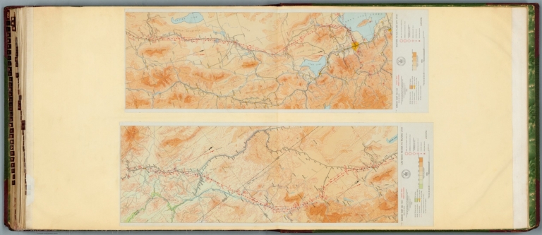
Air navigation map no. 43 (experimental) : Vancouver to Seattle, Washington. Compiled and reproduced by the Engineer Reproduction Plant, Corps of Engineers. Under the direction of the Airways Section, Office Chief of Air Corps. 1927. R-1928. Engineer Reproduction Plant, U.S. Army, Washington Barracks, D.C. 6470. 1927 - R-1929. -- Air navigation map [44] (experimental) : Rantoul, Ill. to Mt. Clemens, Mich. Compiled and reproduced by the Engineer Reproduction Plant, Corps of Engineers. Under the direction of the Airways Section, Office Chief of Air Service. 1925. Engineer Reproduction Plant, U.S. Army, Washington Barracks, D.C. 4915-44.
List No
14501.025
Note
Two aeronautical charts representing the areas from Vancouver to Seattle, Washington, and from Rantoul, Illinois, to Mount Clemens, Michigan. Features military, municipal, commercial, emergency, and seaplane landing fields, as well as beacon lights. Also shows political boundaries, roads, railways, cities, towns, topography, bodies of water, drainage, and coastlines. Relief shown with contour lines and color coding. Maps include latitudinal and longitudinal lines, legend, scale statements, and bar scales given in miles, as well as compass roses oriented toward left of sheet (with slight variation between the two maps). Color lithographs. Together, maps are 54 x 123 cm, on double sheet, 60 x 135 cm. Map number 44 provided with a handwritten annotation.
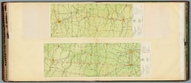
Author
[Ford Motor Company, U.S. Coast and Geodetic Survey]
Full Title
Airway map no. 102 : Dallas to Oklahoma City. Compiled and printed for the Aeronautics Branch of the Department of Commerce by the Coast and Geodetic Survey, Washington, D.C. 1927. -- Airway map no. 103 : Oklahoma City Okla. to Wichita Kan. Compiled and printed for the Aeronautics Branch of the Department of Commerce by the Coast and Geodetic Survey, Washington, D.C. 1929.
List No
14501.032
Note
Two aeronautical charts representing the areas from Dallas, Texas, to Oklahoma City, Oklahoma, and from Oklahoma City to Wichita, Kansas. Features military, municipal, and commercial landing fields, as well as beacons. Also shows political boundaries, roads, railways, cities, towns, topography, bodies of water, and drainage. Relief shown with contour lines and color coding. Maps include latitudinal and longitudinal lines, legend, scale statements, and bar scales given in miles, as well as compass roses oriented toward left of sheet (with slight variation between the two maps). With the seal of the Department of Commerce, United States of America. Color lithographs. Together, maps are 56 x 83 cm, on double sheet, 60 x 136 cm.
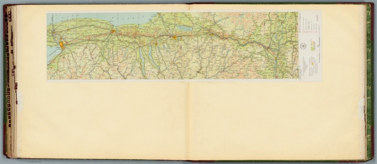
Author
[Ford Motor Company, U.S. Coast and Geodetic Survey]
Full Title
Airway map no. 119 : Buffalo N.Y. to Albany N.Y. Compiled and printed for the Aeronautics Branch of the Department of Commerce by the Coast and Geodetic Survey, Washington, D.C. 1929.
List No
14501.037
Note
Aeronautical chart representing the areas from Buffalo to Albany, New York. Features military, municipal, and commercial landing fields, as well as beacons. Also shows political boundaries, roads, railways, cities, towns, topography, bodies of water, drainage, and shorelines. Relief shown with contour lines and color coding. Map includes a legend, scale statement, and bar scale given in miles, as well as a compass rose oriented toward top of sheet. With the seal of the Department of Commerce, United States of America. Color lithograph. Map is 26 x 106 cm, on double sheet, 60 x 135 cm.
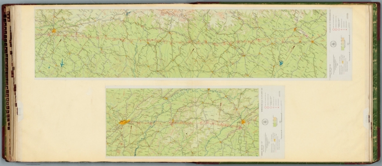
Author
[Ford Motor Company, U.S. Coast and Geodetic Survey]
Full Title
Airway map no. 127 : Birmingham Ala. to Atlanta Ga. Compiled and printed for the Aeronautics Branch of the Department of Commerce by the Coast and Geodetic Survey, Washington, D.C. 1929. -- Airway map no. 128 : Atlanta Ga. to Greensboro N.C. Compiled and printed for the Aeronautics Branch of the Department of Commerce by the Coast and Geodetic Survey, Washington, D.C. 1929.
List No
14501.038
Note
Two aeronautical charts representing the areas from Birmingham, Alabama, to Atlanta, Georgia, and from Atlanta to Greensboro, North Carolina. Features military, municipal, and commercial landing fields, seaplane anchorage and beacons. Also shows political boundaries, roads, railways, cities, towns, topography, bodies of water, and drainage. Relief shown with contour lines and color coding. Maps include latitudinal and longitudinal lines, legend, scale statements, and bar scales given in miles, as well as compass roses oriented toward top of sheet (with slight variation between the two maps). With the seal of the Department of Commerce, United States of America. Color lithographs. Together, maps are 56 x 120 cm, on double sheet, 60 x 135 cm.
Author
[Ford Motor Company, U.S. Coast and Geodetic Survey]
Full Title
Airway map no. 133 : Las Vegas Nevada to Milford Utah. Compiled and printed for the Aeronautics Branch of the Department of Commerce by the Coast and Geodetic Survey, Washington, D.C. 1929. -- Airway map no. 134 : Milford to Salt Lake City Utah. Compiled and printed for the Aeronautics Branch of the Department of Commerce by the Coast and Geodetic Survey, Washington, D.C. 1929.
List No
14501.041
Note
Two aeronautical charts representing the areas from Las Vegas, Nevada, to Milford, Utah, and from Milford to Salt Lake City, Utah. Features military, municipal, and commercial landing fields, seaplane anchorage and beacons. Also shows political boundaries, roads, railways, cities, towns, topography, bodies of water, drainage, and shorelines. Relief shown with contour lines and color coding. Maps include latitudinal and longitudinal lines, legend, scale statements, and bar scales given in miles, as well as compass roses oriented toward top right of sheet (with slight variation between the two maps). With the seal of the Department of Commerce, United States of America. Color lithographs. Together, maps are 57 x 83 cm, on double sheet, 60 x 135 cm.
Author
Rand McNally and Company
Full Title
(Covers to) Rand McNally standard map of Illinois. with air trails. Copyright by Rand McNally & Company, Chicago. (cover title) Advance copy : Rand McNally Air trails map of Illinois. (inset) Chicago and Vicinity.
List No
13004.001
Author
Rand McNally and Company
Full Title
(Text Page to) Rand McNally standard map of Illinois. with air trails. Copyright by Rand McNally & Company, Chicago. (cover title) Advance copy : Rand McNally Air trails map of Illinois. (inset) Chicago and Vicinity.
List No
13004.002
Note
Advance copy pocket airways map of Illinois on sheet 69x49, folded to 24x11. State and county boundaries in outline color. Shows major cities, state capital, county seats, cities, towns, railroads, electric lines, airports, seaplane ports, revolving beacon lights, etc. Includes Air trails legend, wind rose and index to principal cities. Prime meridian is Greenwich. Text Airport directory, index, illustrations and "Comprehensive airway map of the United States" on verso. Date estimated.
Author
Rand McNally and Company
Full Title
Rand McNally standard map of Illinois. with air trails. Copyright by Rand McNally & Company, Chicago. (cover title) Advance copy : Rand McNally Air trails map of Illinois. (inset) Chicago and Vicinity.
List No
13004.003
Author
Radó, Sándor, 1899-1981
Full Title
Die zweite Aufteilung der Welt (1919-1929).
List No
14253.016
Note
Political world map, in color, showing international boundaries between 1919 and 1929 (after World War I). For imperialist powers - Great Britain, France, the United States, Japan, Italy and the Soviet Union - map distinguishes the motherland and colonies, as well as areas of influence and interest. Includes a legend, as well as a text box decoding abbreviations, such as "jap." for "japanisch". Title in lower margin; translates to: The Second Partition of the World (1919-1929). 20 x 30 cm, on sheet 26 x 34 cm. Accompanied by descriptive text on facing page.
Author
Radó, Sándor, 1899-1981
Full Title
Europa 1929.
List No
14253.018
Note
Political map of Europe, in color, showing the international boundaries - including colonies - in 1929. Includes a legend and a bar scale. Title in lower margin; translates to: Europe (1929). 21 x 24 cm, on sheet 26 x 34 cm. Accompanied by descriptive text on facing page.
Author
[White, Ruth Taylor, Western Air Express]
Full Title
(Covers to) Western Air Express Travel by Air : Travel by Western Air Express : Speend - comfort - dependability. Cartograph by Ruth Taylor White. Printed in U.S.A. in October, 1929.
List No
11777.001
Note
Lithograph, pictorial route maps and brochure, produced by Western Air Express, October 1929. With 10 pages of maps, texts and photos folded into covers 12x10. Inside includes tourist information, index, black and white photographs and 4 double page pictorial route maps, covering San Francisco-Los Angeles, Los Angeles-Kansas; Los Angels- to Tia Juana or Agua Caliente and Los Angeles-Salt Lake City and single page map of the United States, map of the United States, showing Air express routes and connecting airlines. Pictorial covers feature pictorial route map with a Tri-motored Fokker type aircraft flying over mountains with arrowhead logo at bottom and caption “Travel by air”. On recto: photograph of of the plane and text at bottom "Travel by Western Air Express : Speed - Comfort - Dependability". and caption “Travel by air”. Maps showing text, flying times and distances, major cites landmarks, forest, winter and Summer sports, recreational activities, places of interest, industry, farms, rivers and mountains.
Author
[White, Ruth Taylor, Western Air Express]
Full Title
San Francisco -Los Angeles : 365 miles - 3 hours. The World's model Air Line. Cartograph by Ruth Taylor White. (to accompany) Western Air Express Travel by Air : Travel by Western Air Express : Speend - comfort - dependability. Cartograph by Ruth Taylor White. Printed in U.S.A. in October, 1929.
List No
11777.002
Note
Double page pictorial map. Showing Western Air express route, flying times and distance, major cites landmarks, forest, winter and Summer sports, recreational activities, places of interest, industry, farms, rivers and mountains. Relief shown pictorially. Includes photo of a Tri-motored Fokker type aircraft, compass rose decorated with arrowhead logo and text "San Francisco- Los Angeles line of the Western Air Express ... established in May 1928 ..."
Author
[White, Ruth Taylor, Western Air Express]
Full Title
Los Angeles-Kansas City : 1,417 miles - 12 hours. First and fastest all daylight passenger airway. Cartograph by Ruth Taylor White. (to accompany) Western Air Express Travel by Air : Travel by Western Air Express : Speend - comfort - dependability. Cartograph by Ruth Taylor White. Printed in U.S.A. in October, 1929.
List No
11777.003
Note
Double page pictorial map. Showing Western Air express routes, flying times and distance, major cites landmarks, forest, winter and Summer sports, recreational activities, places of interest, industry, farms, rivers and mountains. Relief shown pictorially. Includes photo of a Tri-motored Fokker type aircraft, compass rose decorated with arrowhead logo and text "The Western Air Express Los Angeles-Kansa City passenger service was established in May 1929 ..."
Author
[White, Ruth Taylor, Western Air Express]
Full Title
Los Angeles to Tia Juana or Agua Caliente : 116 miles - 1 hour. Los Angeles to Catalina : 45 miles - 30 minutes. Over land and sea. Cartograph by Ruth Taylor White. (to accompany) Western Air Express Travel by Air : Travel by Western Air Express : Speend - comfort - dependability. Cartograph by Ruth Taylor White. Printed in U.S.A. in October, 1929.
List No
11777.004
Note
Double page pictorial map. Showing Western Air express routes, flying times and distance, major cites landmarks, forest, winter and Summer sports, recreational activities, places of interest, industry, farms, rivers and mountains. Relief shown pictorially. Includes text, photos and compass rose decorated with arrowhead logo.
Author
[White, Ruth Taylor, Western Air Express]
Full Title
Los Angeles-Salt Lake City : 600 miles - 6 hours. Over old Mormon Trail. Cartograph by Ruth Taylor White. (to accompany) Western Air Express Travel by Air : Travel by Western Air Express : Speend - comfort - dependability. Cartograph by Ruth Taylor White. Printed in U.S.A. in October, 1929.
List No
11777.005
Note
Double page pictorial map. Showing Western Air express routes, flying times and distance, major cites landmarks, forest, winter and Summer sports, recreational activities, places of interest, industry, farms, rivers and mountains. Relief shown pictorially. Includes a Tri-motored Fokker type aircraft, compass rose decorated with arrowhead logo and text "The Los Angeles-Salt Lake City has bee operating since April, 1926 ..."
Author
[White, Ruth Taylor, Western Air Express]
Full Title
(United States map) Connections at Western Air Express terminals. (to accompany) Western Air Express Travel by Air : Travel by Western Air Express : Speend - comfort - dependability. Cartograph by Ruth Taylor White. Printed in U.S.A. in October, 1929.
List No
11777.006
Note
Double page map, 10x18 on sheet 23x21. Showing Western Air express connections and routes in the United States with inset map of the Terminal in Los Angeles. Includes text, photograph and list of the Western Air Express service points.
Author
Dorn, Frank (1901-1981)
Full Title
Being a Map of a Part of the Military Reservation of Camp Stotsenburg · Province of Pampanga · Philippine Islands
List No
15444.000
Author
[Heim, Albert, Imhof, Eduard, 1895-1986]
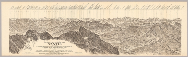
Full Title
(Covers to) Rundsicht vom Gipfel des Santis. VIII Auflage. Revision und Reliefton von Prof. Ed. Imhof.
List No
15397.001
Author
[Heim, Albert, Imhof, Eduard, 1895-1986]
Full Title
BL I Rundsicht vom Gipfel des Santis. VIII Auflage. Revision und Reliefton von Prof. Ed. Imhof.
List No
15397.002
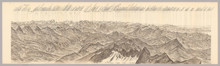
Author
[Heim, Albert, Imhof, Eduard, 1895-1986]
Full Title
BL II Rundsicht vom Gipfel des Santis. VIII Auflage. Revision und Reliefton von Prof. Ed. Imhof.
List No
15397.003
Author
[Heim, Albert, Imhof, Eduard, 1895-1986]
Full Title
BL III Rundsicht vom Gipfel des Santis. VIII Auflage. Revision und Reliefton von Prof. Ed. Imhof.
List No
15397.004
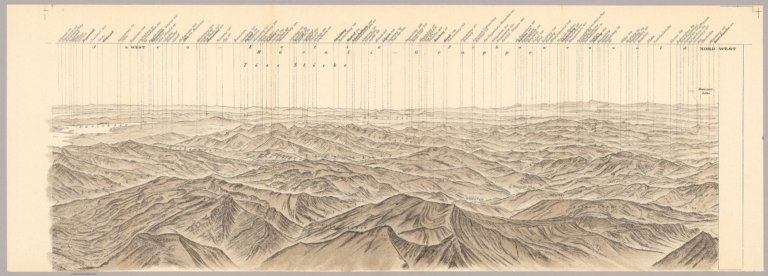
Author
[Heim, Albert, Imhof, Eduard, 1895-1986]
Full Title
BL IV Rundsicht vom Gipfel des Santis. VIII Auflage. Revision und Reliefton von Prof. Ed. Imhof.
List No
15397.005
Author
[Heim, Albert, Imhof, Eduard, 1895-1986]
Full Title
BL V Rundsicht vom Gipfel des Santis. VIII Auflage. Revision und Reliefton von Prof. Ed. Imhof.
List No
15397.006
Author
[Heim, Albert, Imhof, Eduard, 1895-1986]
Full Title
BL VI Rundsicht vom Gipfel des Santis. VIII Auflage. Revision und Reliefton von Prof. Ed. Imhof.
List No
15397.007
Author
[Heim, Albert, Imhof, Eduard, 1895-1986]
Full Title
(Composite view to) BL I - VI Rundsicht vom Gipfel des Santis. VIII Auflage. Revision und Reliefton von Prof. Ed. Imhof.
List No
15397.008
Author
[Confederazione generale dell'industria italiana, Associzaione fra le società italiane per azioni]
Full Title
(Covers to) Lo sviluppo dell'industria italiana. Confederazione generale fascista delliIndustria Iialiana, Associzaione fra le società italiane per azioni. 1929-VII. Litografia del Genio Civile, Roma.
List No
14403.001
Note
Covers to Lo sviluppo dell'industria italiana. Bound in gray paper covers tied with maroon cord. Front cover includes title and imprint. Title translates to: The development of Italian industry.
Author
[Confederazione generale dell'industria italiana, Associzaione fra le società italiane per azioni]
Full Title
(Title Page to) Lo sviluppo dell'industria italiana. Confederazione generale fascista delliIndustria Iialiana, Associzaione fra le società italiane per azioni. 1929-VII. Litografia del Genio Civile, Roma.
List No
14403.002
Note
Title page to Lo sviluppo dell'industria italiana. Title translates to: The development of Italian industry.
Author
[Confederazione generale dell'industria italiana, Associzaione fra le società italiane per azioni]
Full Title
Capitale delle S. A, industriali : In lire oro.
List No
14403.015
Note
Chart showing the capital of industrialists in Italy, according to gold lire, from 1876 to 1928. Includes descriptive text. Colored lithograph, on sheet 21 x 29 cm.
Author
[Confederazione generale dell'industria italiana, Associzaione fra le società italiane per azioni]
Full Title
Industria mineraria : Valore della produzione (lire attvali).
List No
14403.021
Note
Chart showing the production value within the mining industry in Italy, from 1876 to 1927. Includes descriptive text. Colored lithograph, on sheet 21 x 29 cm.
Author
[Confederazione generale dell'industria italiana, Associzaione fra le società italiane per azioni]
Full Title
Industrie automobilistica : Produzione di automobili -- Numero degli automobili in circolazione nei vari anni.
List No
14403.030
Note
Two charts showing car manufacturing within the automotive industry and the number of cars on the road in Italy, from 1900 to 1928. Includes descriptive text. Colored lithograph, on sheet 21 x 29 cm.
Author
[Confederazione generale dell'industria italiana, Associzaione fra le società italiane per azioni]
Full Title
Industria elettrica : Consumo di energia elettrica (rilevazione del ministero delle finanze) (kwh).
List No
14403.035
Note
Chart showing electricity consumption (in kilowatt-hours, according to a survey from the Ministry of Finance), within the electric industry in Italy, from 1898 to 1928. Includes descriptive text. Colored lithograph, on sheet 21 x 29 cm.
Author
[Confederazione generale dell'industria italiana, Associzaione fra le società italiane per azioni]
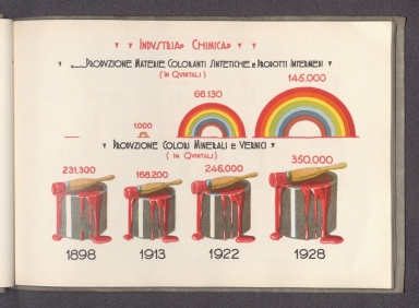
Full Title
Industria chimica : Produzione materie coloranti sintetiche e prodotti intermedi (in quintali) -- Produzione colori minerali e vernici (in quintali).
List No
14403.039
Note
Two charts showing the production of synthetic coloring materials and intermediate products, as well as mineral colors and varnishes (in quintals) within the chemical industry in Italy, from 1898 to 1928. Includes descriptive text. Colored lithograph, on sheet 21 x 29 cm.
Author
[Confederazione generale dell'industria italiana, Associzaione fra le società italiane per azioni]
Full Title
Industria cotoniera : Fusi di filatura installati.
List No
14403.045
Note
Chart showing spindles within the cotton industry in Italy, from 1876 to 1928. Includes descriptive text. Colored lithograph, on sheet 21 x 29 cm.
Author
[Confederazione generale dell'industria italiana, Associzaione fra le società italiane per azioni]
Full Title
Industria delle ceramiche : Esportazione di maioliche terraglie e porcellane (escluse le terrecotte) (ql).
List No
14403.073
Note
Chart showing the export of pottery and porcelain (excluding terra cotta) within the ceramics industry in Italy, from 1876 to 1928. Includes descriptive text. Colored lithograph, on sheet 21 x 29 cm.
Author
[Confederazione generale dell'industria italiana, Associzaione fra le società italiane per azioni]
Full Title
Industria della birra : Produzione di birra (in ettolitri).
List No
14403.077
Note
Chart showing the production of beer (in hectoliters) within the brewing industry in Italy, from 1879 to 1928. Includes descriptive text. Colored lithograph, on sheet 21 x 29 cm.
Author
[Confederazione generale dell'industria italiana, Associzaione fra le società italiane per azioni]
Full Title
Industria delle conserve alimentari : Esportazione di conserve di pomodoro (ql) -- Esportazione di carni salate affumicate in altro modo preparate (escluso il lardo) (ql).
List No
14403.080
Note
Two charts showing the export of canned tomatoes and salted, smoked meat within the food canning industry in Italy, from 1876 to 1928. Includes descriptive text. Colored lithograph, on sheet 21 x 29 cm.
Author
[Confederazione generale dell'industria italiana, Associzaione fra le società italiane per azioni]
Full Title
Ferrovie : Tonnellate di merci trasportate sulla rete esercitata dallo stato.
List No
14403.086
Note
Chart showing the tons of goods transported along the Italian railway network, from 1906 to 1928. Includes descriptive text. Colored lithograph, on sheet 21 x 29 cm.
Author
[Confederazione generale dell'industria italiana, Associzaione fra le società italiane per azioni]
Full Title
Telefoni : Servizio interurbano e internazionale lunghezza dei circuiti in km.
List No
14403.089
Note
Chart showing the length of circuits for long-distance and international service telephone in Italy, from 1876 to 1928. Includes descriptive text. Colored lithograph, on sheet 21 x 29 cm.
Author
[Pantoflíček, Jaroslav, Česká akademie věd a umění.]
Full Title
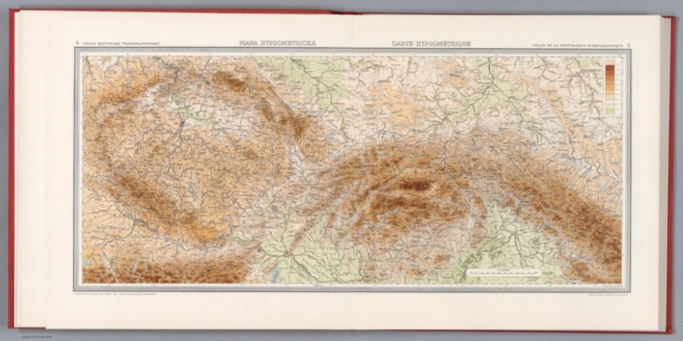
Mapa hypsometrica = Carte hypsometrique. Fr. Machát; M. Semík. 4. Atlas Republiky Československé = Atlas de la Republique Tchecoslovaque. Vydala Ceska akademie ved a umeni -1929- Editeur Nakladatelstvi Orbis, Praha : Tiskne Vojenskyì zeměpisnyì uìstav.
List No
13678.010
Note
Hypsometric map of Czechoslovakia on 2 sheets. Relief shown by contours, spot heights and gradient tints. Includes legend.
Author
[Pantoflíček, Jaroslav, Česká akademie věd a umění.]
Full Title
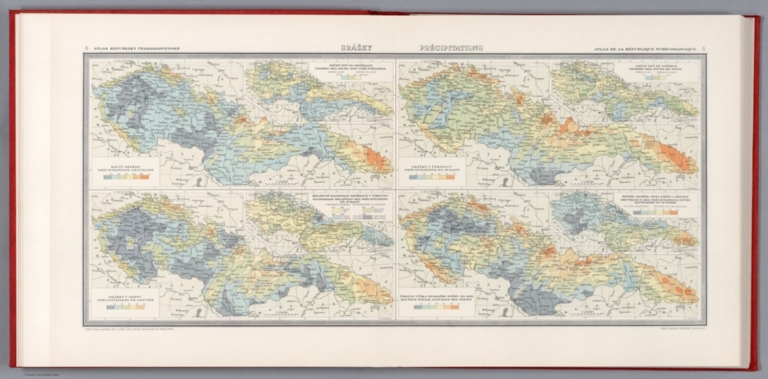
Srazky = Precipitations. J. Smetana. 8. Atlas Republiky Československé = Atlas de la Republique Tchecoslovaque. Vydala Ceska akademie ved a umeni -1929- Editeur Nakladatelstvi Orbis, Praha : Tiskne Vojenskyì zeměpisnyì uìstav.
List No
13678.014
Note
4 meteorological maps, with insets on 2 sheets. Relief shown by contours and spot heights. Showing rainfall stations and isolines with mean annual rainfall and in January and July. 1 map shows the total annual snowfall. Charts showing fluctuation in precipitation. Includes legend.
Author
[Pantoflíček, Jaroslav, Česká akademie věd a umění.]
Full Title
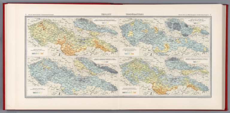
Teploty = Temperatures. V. Laska. A. Gregor. 9. Atlas Republiky Československé = Atlas de la Republique Tchecoslovaque. Vydala Ceska akademie ved a umeni -1929- Editeur Nakladatelstvi Orbis, Praha : Tiskne Vojenskyì zeměpisnyì uìstav.
List No
13678.015
Note
4 meteorological maps, with insets on 2 sheets. Relief shown by spot heights. Showing different temperature zones in January and July and annual isanomals of mean surface-temperature. Includes legend.
Author
[Oficina Cartográfica Ludwig, Cannizzaro, A.]
Full Title
(Covers to) Plano De La Ciudad De Buenos Aires Y Sus Alrededores.
List No
10916.001
Note
Includes index book 16 pages.
Author
[Oficina Cartográfica Ludwig, Cannizzaro, A.]
Full Title
(Text page to) Plano De La Ciudad De Buenos Aires Y Sus Alrededores.
List No
10916.002
Note
Includes index book 16 pages.
Author
[Oficina Cartográfica Ludwig, Cannizzaro, A.]
Full Title
Plano De La Ciudad De Buenos Aires Y Sus Alrededores.
List No
10916.003
Note
Includes index book 16 pages.
Author
[Gill, Leslie MacDonald, 1884-1947, Empire Marketing Board]
Full Title
Irish Free State & Northern Ireland Portraying Their Agricultural Products & Fisheries 1929
List No
10812.000
Author
[Gill, Leslie MacDonald, 1884-1947, Empire Marketing Board]
Full Title
A Map of Scotland Portraying Her Agricultural Products & Fisheries 1929.
List No
10778.000
Author
[Gill, Leslie MacDonald, 1884-1947, Empire Marketing Board]
Full Title
A Map of the Union of South Africa Portraying Her Agricultural Products & Fisheries.
List No
10779.000
Author
[Wong, J. P., Huapei Huang]
Full Title
Mei guo san fan shi hua qiao qu : xiang xi tu = Map of San Francisco Chinatown. Published September, 1929. Compiled by J. P. Wong.
List No
10300.000
Note
Lithograph map with 2 insets, showing the extent of Chinatown in San Francisco and, in the second inset map, the extent of Oakland's Chinatown. Drawn by J. P. Wong. The main map is in Mandarin and English. Oriented with north towards lower right. It is the first map made by Chinese Americans of San Francisco for the Chinese community. The map depicts the largest Chinatown in North America during the Roaring '20s, an especially dramatic period in the neighborhood's history. It shows city blocks and building lots, each with appropriate street address numbers. The map was made for the Benevolent Association also known as the Chinese Six companies formed in 1882. The map is horizontally centered on Grant Street the heart of the neighborhood, bordered by Bush Street, Broadway Street on the north, Powell Street on the west, and Montgomery Street on the east. The street names and a few properties are in English, all other Chinese businesses and residence are in Chinese. This copy with applied water color showing Chinatown as delineated in Willard B. Farwell's 1885 large folding map "Official map of Chinatown in San Francisco Chinatown" made for the Board of Supervisors reporting on the condition of the Chinese Quarter and the Chinese of San Francisco (see our 6714.000). The 1885 map was also issued in smaller size in the San Francisco Municipal Report of 1884-85 (see our 5807.000). The color scheme on this 1929 map appears to be updated significantly from the 1885 map. Some of the updating may relate to the rebuilding of Chinatown after the 1906 earthquake. It is possible that the color was not applied in the original publishing, but later by someone else.
Author
[Nirenstein, Nathan, Funk & Wagnalls Company.]
Full Title
(Title Page) Preferred Business Real Estate Locations of the Principal Cities of the United States and Canada. Compiled from Actual Surveys and Official Plans, by Cobb, Beesley & Miles, Civil Engineers, Springfield, Massachusetts, under the personal direction of Nathan Nirenstein. Published by Nathan Nirenstein, Springfield, Massachusetts, U.S.A. (Legend).
List No
12508.002
Note
Date estimated.
Author
[Tripp, B. Ashburton, 1887-1955, Funk & Wagnalls Company.]
Full Title
The Hebrew Garden, Rockefeller Park, Cleveland. B. Ashburton Tripp Landscape Architect.
List No
8646.000
Note
Manuscript plan of the Hebrew Garden in the Cleveland Cultural Gardens in Rockefeller Park. Tripp also designed the Italian Cultural Garden for Rockefeller Park (see our 8645.000). This plan was included in the 1929 May Show at the Cleveland Museum of Art and the date is estimated from that event.
Author
[Transcontinental Air Transport, Inc., Funk & Wagnalls Company.]
Full Title
(Map of the United States showing the air route from Los Angeles, California to Columbus, Ohio). Copyright, Rand McNally & Company.
List No
3704.001
Note
Map shows the air route from Los Angeles to Columbus in full color. From Clovis, New Mexico to Waynoka, Oklahoma it was still necessary to travel that section by rail. The map also shows the TAT weather reporting stations begun specifically to service this air route. By teletype the observers were able to communicate with the pilots about weather conditions in the upcoming regions. The "Certificate of Flight" was completed by Mason Menefee. He departed Los Angeles on April 25, 1930 and went as far as St. Louis, Missouri.
Author
[Transcontinental Air Transport, Inc., Funk & Wagnalls Company.]
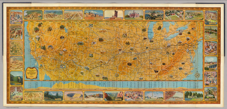
Full Title
Illustrated Map of the Route of Transcontinental Air Transport, Inc. TAT. Copyright, Rand McNally & Company. 7134 - New York 6-29.
List No
3704.002
Note
Map in full color with drawings of interesting features in the United States. Below the main map is an elevation profile with lines leading up to the point along the route noted below. The profile delineates the states, mileage and the height of the features on the profile. The route of the airplane is shown in blue and includes an airplane making the trip. Surround the map and profile are drawings of natural features and cities throughout the United States.
Author
[Touring club italiano, Funk & Wagnalls Company.]
Full Title
(Covers to) Atlante internazionale del Touring club italiano. (3. ed.). Centosettanta tavole principali, centrotrenta carte parziali e di suiluppo. Opera redatta ed eseguita nell'Ufficio cartografico del T.C.I. sotto la direzione di L.V. Bertarelli, O. Marinelli, P. Corbellini. Milano: Touring club italiano. MDCCCCXXIX/VII.
List No
1012AA
Note
Bound in dark green cloth.
Author
[Touring club italiano, Funk & Wagnalls Company.]
Full Title
(Half Title Page to) Atlante internazionale del Touring club italiano. (3. ed.). Centosettanta tavole principali, centrotrenta carte parziali e di suiluppo. Opera redatta ed eseguita nell'Ufficio cartografico del T.C.I. sotto la direzione di L.V. Bertarelli, O. Marinelli, P. Corbellini. Milano: Touring club italiano. MDCCCCXXIX/VII.
List No
1012AB
Author
[Touring club italiano, Funk & Wagnalls Company.]
Full Title
(Title Page to) Atlante internazionale del Touring club italiano. (3. ed.). Centosettanta tavole principali, centrotrenta carte parziali e di suiluppo. Opera redatta ed eseguita nell'Ufficio cartografico del T.C.I. sotto la direzione di L.V. Bertarelli, O. Marinelli, P. Corbellini. Milano: Touring club italiano. MDCCCCXXIX/VII.
List No
1012AC
Note
Bound in dark green cloth. Bibliographical, explanatory and statistical notes are printed on the versos of the maps.
Author
[Touring club italiano, Funk & Wagnalls Company.]
Full Title
(Dedication Page) Atlante internazionale del Touring club italiano. (3. ed.). Centosettanta tavole principali, centrotrenta carte parziali e di suiluppo. Opera redatta ed eseguita nell'Ufficio cartografico del T.C.I. sotto la direzione di L.V. Bertarelli, O. Marinelli, P. Corbellini. Milano: Touring club italiano. MDCCCCXXIX/VII.
List No
1012AD
Note
Verso of title page containing copyright notice and "Stampato nelle officine G. Ricordi & C., Milano, with facing dedication page to Benito Mussolini by G. Bognetti, President of T.C.I.
Author
[Touring club italiano, Funk & Wagnalls Company.]
Full Title
(Text Page to) Atlante internazionale del Touring club italiano. (3. ed.). Centosettanta tavole principali, centrotrenta carte parziali e di suiluppo. Opera redatta ed eseguita nell'Ufficio cartografico del T.C.I. sotto la direzione di L.V. Bertarelli, O. Marinelli, P. Corbellini. Milano: Touring club italiano. MDCCCCXXIX/VII.
List No
1012AE
Note
Introduction.
Author
[Touring club italiano, Funk & Wagnalls Company.]
Full Title
(Text Page to) Atlante internazionale del Touring club italiano. (3. ed.). Centosettanta tavole principali, centrotrenta carte parziali e di suiluppo. Opera redatta ed eseguita nell'Ufficio cartografico del T.C.I. sotto la direzione di L.V. Bertarelli, O. Marinelli, P. Corbellini. Milano: Touring club italiano. MDCCCCXXIX/VII.
List No
1012AF
Note
Introduction (continued)
Author
[Touring club italiano, Funk & Wagnalls Company.]
Full Title
(Text Page to) Atlante internazionale del Touring club italiano. (3. ed.). Centosettanta tavole principali, centrotrenta carte parziali e di suiluppo. Opera redatta ed eseguita nell'Ufficio cartografico del T.C.I. sotto la direzione di L.V. Bertarelli, O. Marinelli, P. Corbellini. Milano: Touring club italiano. MDCCCCXXIX/VII.
List No
1012AG
Note
Introduction (continued) with title page to "Indice delle tavole ..." on facing page.
Author
[Touring club italiano, Funk & Wagnalls Company.]
Full Title
(Contents to) Atlante internazionale del Touring club italiano. (3. ed.). Centosettanta tavole principali, centrotrenta carte parziali e di suiluppo. Opera redatta ed eseguita nell'Ufficio cartografico del T.C.I. sotto la direzione di L.V. Bertarelli, O. Marinelli, P. Corbellini. Milano: Touring club italiano. MDCCCCXXIX/VII.
List No
1012AH
Note
"Tavole dell'Atlante internazionale del T.C.I."
Author
[Touring club italiano, Funk & Wagnalls Company.]
Full Title
Emisferi fisici. Propr. Artistico-letteraria del T.C.I. Ufficio cartografico del T.C.I. (1929)
List No
1012.001
Note
Color double hemisphere map. Relief and depths shown by altitude and depth tints and spot heights. "1-2-3." Title on verso: Emisferi fisici, 1-2-3. Maps on verso: Terre polari.
Author
[Touring club italiano, Funk & Wagnalls Company.]
Full Title
Terre polari. (Propr. Artistico-letteraria del T.C.I. Ufficio cartografico del T.C.I. 1929)
List No
1012.002
Note
Two color maps. Relief shown by spot heights.
Author
[Touring club italiano, Funk & Wagnalls Company.]
Full Title
(Legend) Linee di comunicazione del Oceano Atlantico. (Propr. Artistico-letteraria del T.C.I. Ufficio cartografico del T.C.I. 1929)
List No
1012AI
Note
Explanation to map. "Vie di comunicazione dell'Oceano Atlantico."
Author
[Touring club italiano, Funk & Wagnalls Company.]
Full Title
Linee di comunicazione del Oceano Atlantico. Propr. Artistico-letteraria del T.C.I. Ufficio cartografico del T.C.I. (1929)
List No
1012.003
Note
Color map.
Author
[Touring club italiano, Funk & Wagnalls Company.]
Full Title
(Legend) Linee di comunicazione degli oceani Indiano e Pacifico. (Propr. Artistico-letteraria del T.C.I. Ufficio cartografico del T.C.I. 1929)
List No
1012AJ
Note
Explanation to map. "Vie di comunicazione degli oceani Indiano e Pacifico."
Author
[Touring club italiano, Funk & Wagnalls Company.]
Full Title
Linee di comunicazione degli oceani Indiano e Pacifico. Propr. Artistico-letteraria del T.C.I. Ufficio cartografico del T.C.I. (1929)
List No
1012.004
Note
Color map.
Author
[Touring club italiano, Funk & Wagnalls Company.]
Full Title
(Legend) Linee di comunicazione dell'Europa centrale e Mediterranea. (Propr. Artistico-letteraria del T.C.I. Ufficio cartografico del T.C.I. 1929)
List No
1012AK
Note
Explanation to map. "Vie di comunicazione del Mediterraneo."
Author
[Touring club italiano, Funk & Wagnalls Company.]
Full Title
Linee di comunicazione dell'Europa centrale e Mediterranea. Propr. Artistico-letteraria del T.C.I. Ufficio cartografico del T.C.I. (1929)
List No
1012.005
Note
Color map.
Author
[Touring club italiano, Funk & Wagnalls Company.]
Full Title
(Legend) Europa fisica. (Propr. Artistico-letteraria del T.C.I. Ufficio cartografico del T.C.I. 1929)
List No
1012AL
Note
Explanation to map.
Author
[Touring club italiano, Funk & Wagnalls Company.]
Full Title
Europa fisica. Propr. Artistico-letteraria del T.C.I. Ufficio cartografico del T.C.I. (1929)
List No
1012.006
Note
Color map. Relief and depths shown by altitude and depth tints and spot heights.
Author
[Touring club italiano, Funk & Wagnalls Company.]
Full Title
(Legend) Europa politica. (Propr. Artistico-letteraria del T.C.I. Ufficio cartografico del T.C.I. 1929)
List No
1012AM
Note
Explanation to map.
Author
[Touring club italiano, Funk & Wagnalls Company.]
Full Title
Europa politica. Propr. Artistico-letteraria del T.C.I. Ufficio cartografico del T.C.I. (1929)
List No
1012.007
Note
Color map. Shows railroads, etc.
Author
[Touring club italiano, Funk & Wagnalls Company.]
Full Title
(Legend) Europa etnografica. (Propr. Artistico-letteraria del T.C.I. Ufficio cartografico del T.C.I. 1929)
List No
1012AN
Note
Explanation to map.
Author
[Touring club italiano, Funk & Wagnalls Company.]
Full Title
Europa etnografica. Propr. Artistico-letteraria del T.C.I. Ufficio cartografico del T.C.I. (1929)
List No
1012.008
Note
Color map.
Author
[Touring club italiano, Funk & Wagnalls Company.]
Full Title
Europa etnografica. Propr. Artistico-letteraria del T.C.I. Ufficio cartografico del T.C.I. (1929)
List No
1012.009
Note
Color map.
Author
[Touring club italiano, Funk & Wagnalls Company.]
Full Title
(Legend to) Alpi fisiche. Propr. Artistico-letteraria del T.C.I. Ufficio cartografico del T.C.I. (1929)
List No
1012AO
Note
Explanation to map.
Author
[Touring club italiano, Funk & Wagnalls Company.]
Full Title
Alpi fisiche. Propr. Artistico-letteraria del T.C.I. Ufficio cartografico del T.C.I. (1929)
List No
1012.010
Note
Color map. Relief and depths shown by altitude and depth tints and spot heights. Includes 3 insets at 1:250,000 scale of the Jungfrau, Matterhorn-Monte Rosa and Mont Blanc areas.
Author
[Touring club italiano, Funk & Wagnalls Company.]
Full Title
(Legend to) Svizzera, Schweiz, Suisse. Propr. Artistico-letteraria del T.C.I. Ufficio cartografico del T.C.I. (1929)
List No
1012AP
Note
Explanation to map.
Author
[Touring club italiano, Funk & Wagnalls Company.]
Full Title
Svizzera, Schweiz, Suisse. Propr. Artistico-letteraria del T.C.I. Ufficio cartografico del T.C.I. (1929)
List No
1012.011
Note
Color map. Relief shown by hachures and spot heights.
Author
[Touring club italiano, Funk & Wagnalls Company.]
Full Title
(Legend to) Italia. Propr. Artistico-letteraria del T.C.I. Ufficio cartografico del T.C.I. (1929)
List No
1012AQ
Note
Explanation to map.
Author
[Touring club italiano, Funk & Wagnalls Company.]
Full Title
Italia. Propr. Artistico-letteraria del T.C.I. Ufficio cartografico del T.C.I. (1929)
List No
1012.012
Note
Color map. Relief shown by hachures and spot heights. Includes 1:250,000 scale insets of the Venezia, Genova and Trieste regions.
Author
[Touring club italiano, Funk & Wagnalls Company.]
Full Title
(Legend to) Italia: foglio nord. Propr. Artistico-letteraria del T.C.I. Ufficio cartografico del T.C.I. (1929)
List No
1012AR
Note
Explanation to map.
Author
[Touring club italiano, Funk & Wagnalls Company.]
Full Title
Italia: foglio nord. Propr. Artistico-letteraria del T.C.I. Ufficio cartografico del T.C.I. (1929)
List No
1012.013
Note
Color map. Relief shown by hachures and spot heights; depths by isolines. Includes 1:15,000 scale inset of Vatican City and 1:250,000 scale insets of the Torino, Milano, Bologna, Roma and Firenze regions.
Author
[Touring club italiano, Funk & Wagnalls Company.]
Full Title
(Legend to) Italia: foglio sud. Propr. Artistico-letteraria del T.C.I. Ufficio cartografico del T.C.I. (1929)
List No
1012AS
Note
Explanation to map.
Author
[Touring club italiano, Funk & Wagnalls Company.]
Full Title
Italia: foglio sud. Propr. Artistico-letteraria del T.C.I. Ufficio cartografico del T.C.I. (1929)
List No
1012.014
Note
Color map. Relief shown by hachures and spot heights; depths by isolines. Includes 1:250,000 scale insets of the Palermo, Catania and Naples regions.
Author
[Touring club italiano, Funk & Wagnalls Company.]
Full Title
(Legend to) Francia. Propr. Artistico-letteraria del T.C.I. Ufficio cartografico del T.C.I. (1929)
List No
1012AT
Note
Explanation to map.
Author
[Touring club italiano, Funk & Wagnalls Company.]
Full Title
Francia, France. Propr. Artistico-letteraria del T.C.I. Ufficio cartografico del T.C.I. (1929)
List No
1012.015
Note
Color map. Relief shown by hachures and spot heights; depths by isolines. Includes 1:250,000 scale inset of the Paris Region, and 1:750,000 scale insets of the Auvergne Region and the Rivera.
Author
[Touring club italiano, Funk & Wagnalls Company.]
Full Title
(Legend to) Francia, foglio nord. Propr. Artistico-letteraria del T.C.I. Ufficio cartografico del T.C.I. (1929)
List No
1012AU
Note
Explanation to map.
Author
[Touring club italiano, Funk & Wagnalls Company.]
Full Title
Francia, France, foglio nord. Propr. Artistico-letteraria del T.C.I. Ufficio cartografico del T.C.I. (1929)
List No
1012.016
Note
Color map. Relief shown by hachures and spot heights; depths by isolines. Includes 1:750,000 scale insets of the Paris, Brest, Pas de Calais-Flanders-Brabant-Hainaut, Reims, Nancy, Le Havre and Nantes regions.
Author
[Touring club italiano, Funk & Wagnalls Company.]
Full Title
(Legend to) Francia, foglio sud. Propr. Artistico-letteraria del T.C.I. Ufficio cartografico del T.C.I. (1929)
List No
1012AV
Note
Explanation to map.
Author
[Touring club italiano, Funk & Wagnalls Company.]
Full Title
Francia, France, foglio sud. Propr. Artistico-letteraria del T.C.I. Ufficio cartografico del T.C.I. (1929)
List No
1012.017
Note
Color map. Relief shown by hachures and spot heights; depths by isolines. Includes of Corsica, and 1:750,000 scale insets of the Hautes Pyrenees, Marseille-Toulon-St. Tropez and Lyon regions.
Author
[Touring club italiano, Funk & Wagnalls Company.]
Full Title
(Legend to) Spagna e Portogallo, Espana y Portugal. Propr. Artistico-letteraria del T.C.I. Ufficio cartografico del T.C.I. (1929)
List No
1012AW
Note
Explanation to map.
Author
[Touring club italiano, Funk & Wagnalls Company.]
Full Title
Spagna e Portogallo, Espana y Portugal. Propr. Artistico-letteraria del T.C.I. Ufficio cartografico del T.C.I. (1929)
List No
1012.018
Note
Color map. Relief shown by hachures and spot heights; depths by isolines. Includes insets of Madeira (1:1,500,000), Madrid Region (1:250,000 and 1:500,000) and Lisboa Region (1:250,000)
Author
[Touring club italiano, Funk & Wagnalls Company.]
Full Title
(Legend to) Spagna e Portogallo, Espana y Portugal, foglio ouest. Propr. Artistico-letteraria del T.C.I. Ufficio cartografico del T.C.I. (1929)
List No
1012AX
Note
Explanation to map.
Author
[Touring club italiano, Funk & Wagnalls Company.]
Full Title
Spagna e Portogallo, Espana y Portugal, foglio ouest. Propr. Artistico-letteraria del T.C.I. Ufficio cartografico del T.C.I. (1929)
List No
1012.019
Note
Color map. Relief shown by hachures and spot heights; depths by isolines.
Author
[Touring club italiano, Funk & Wagnalls Company.]
Full Title
(Legend to) Spagna e Portogallo, Espana y Portugal, foglio est. Propr. Artistico-letteraria del T.C.I. Ufficio cartografico del T.C.I. (1929)
List No
1012AY
Note
Explanation to map.
Author
[Touring club italiano, Funk & Wagnalls Company.]
Full Title
Spagna e Portogallo, Espana y Portugal, foglio est. (with) Barcelona. (with) Islas Canarias. Propr. Artistico-letteraria del T.C.I. Ufficio cartografico del T.C.I. (1929)
List No
1012.020
Note
Color map. Relief shown by hachures and spot heights; depths by isolines. Barcelona inset at 1:250,000; Canary Islands inset at 1:3,000,000 scale.
Author
[Touring club italiano, Funk & Wagnalls Company.]
Full Title
Spagna e Portogallo, Espana y Portugal, foglio sud. Propr. Artistico-letteraria del T.C.I. Ufficio cartografico del T.C.I. (1929)
List No
1012.021
Note
Color map. Relief shown by hachures and spot heights; depths by isolines. Covers also northern Morocco. Includes insets at 1:750,000 scale of the Strait of Gibraltar and of the Granada-Almeria Region.
Author
[Touring club italiano, Funk & Wagnalls Company.]
Full Title
(Legend to) Spagna e Portogallo, Espana y Portugal, foglio sud. Propr. Artistico-letteraria del T.C.I. Ufficio cartografico del T.C.I. (1929)
List No
1012AZ
Note
Explanation to map.
Author
[Touring club italiano, Funk & Wagnalls Company.]
Full Title
Belgio e Olanda, Belgique, Belgie, Nederland. Propr. Artistico-letteraria del T.C.I. Ufficio cartografico del T.C.I. (1929)
List No
1012.022
Note
Color map. Relief shown by hachures and spot heights; depths by isolines. Covers also Luxembourg. Includes insets at 1:250,000 scale of the Brussels, Antwerp and Amsterdam-Haarlem regions.
|