|
Author
[Ford Motor Company, United States. Department of Commerce. Aeronautics Branch]
Full Title
Commerce and Army Air Corps airway maps : Department of Commerce maps -- Air Corps maps -- Hydrographic Office. Airway bulletin. No. 11a, August 26, 1927. Published in Information Division, Aeronautics Branch, Department of Commerce, Washington, D.C. U.S. Government Printing Office : 1927.
List No
14501.002
Note
Four aeronautical charts of the United States. Charts feature airway strips. Charts also show political boundaries, cities with airports, bodies of water and coastlines. The first chart (printed on a white plate) is an index to the following three charts (printed in white on a black plate). The index chart includes a legend and bar scale given in miles. The following three charts each pertain to different departments - the Department of Commerce, Air Corps and Hydrographic Office - and each chart has a list of available maps, which are identifiable through the index map. Both plates are pasted to a double sheet. Together, maps are 37 x 99 cm, on double sheet, 60 x 136 cm.
Author
[Ford Motor Company, United States. Army. Air Corps, Geological Survey (U.S.). Topographic Branch]
Full Title
Air navigation map no. 1 (experimental) : Dayton, Ohio to Uniontown, Pa. Compiled and reproduced by the Engineer Reproduction Plant, Corps of Engineers. Under the direction of the Airways Section, Office Chief of Air Corps. 1926, Engineer Reproduction Plant, U.S. Army, Washington Barracks, D.C. 6833. R-1927. -- Air navigation map no. 2 : Washington D.C. to Uniontown, Pa. Prepared under the direction of the Airways Section, Office of the Chief of Air Corps by the Topographic Branch, U.S. Geological Survey, 1923. Revised by Engineer Reproduction Plant, U.S. Army, 1927. Engineer Reproduction Plant, U.S. Army, Washington, D.C. 6919. 1927.
List No
14501.003
Note
Two aeronautical charts representing the areas from Dayton, Ohio, to Uniontown, Pennsylvania, and from Washington D.C., to Uniontown, Pennsylvania and Wheeling, West Virginia. Features military, municipal, commercial, emergency, and seaplane landing fields. Also shows political boundaries, roads, railways, cities, towns, topography, bodies of water, and drainage. Relief shown with contour lines and color coding. Maps include latitudinal and longitudinal lines, legend, scale statements, and bar scales given in miles, as well as compass roses oriented toward top of sheet (with slight variation between the two maps). Color lithographs. Together, maps are 56 x 103 cm, on double sheet, 60 x 136 cm.
Author
[Ford Motor Company, Geological Survey (U.S.). Topographic Branch]
Full Title
Air navigation map no. 3 (experimental) : Washington D.C. to New York, N.Y. Prepared under the direction of the Airways Section Office of the Chief of Air Service by the Topographic Branch, U.S. Geological Survey, 1923. Engineer Reproduction Plant, U.S. Army, Washington Barracks, D.C. 4915. 1923 - reprint 1926 - R-1927. -- Air navigation map [4] (experimental) : Washington D.C. to Hampton, Va. Prepared under the direction of the Airways Section, Office of the Chief of Air Corps by the Topographic Branch, U.S. Geological Survey, 1923. Engineer Reproduction Plant, U.S. Army, Washington Barracks, D.C. 6520. 1926.
List No
14501.004
Note
Two aeronautical charts representing the areas from Washington D.C., to New York, New York, and from Washington D.C. to Hampton, Virginia. Features military, municipal, commercial, emergency, and seaplane landing fields, as well as beacon lights. Also shows political boundaries, roads, railways, cities, towns, topography, bodies of water, and drainage. Relief shown with contour lines and color coding. Maps include latitudinal and longitudinal lines, legend, scale statements, and bar scales given in miles, as well as compass roses oriented toward top of sheet (with slight variation between the two maps). Color lithographs. Together, maps are 57 x 94 cm, on double sheet, 60 x 136 cm. Map number 4 provided with a handwritten annotation.
Author
[Ford Motor Company, Geological Survey (U.S.). Topographic Branch]
Full Title
Air navigation map [5] (experimental) : Dayton, Ohio to Rantoul, Ill. Prepared under the direction of the Airways Section Office of the Chief of Air Service by the Topographic Branch, U.S. Geological Survey, 1924. Engineer Reproduction Plant, U.S. Army, Washington Barracks, D.C. 1926, 4915-5. -- Air navigation map no. 6 (experimental) : New York, N.Y. to Boston, Mass. Prepared under the direction of the Airways Section Office of the Chief of Air Corps by the Topographic Branch, U.S. Geological Survey, 1924. Engineer Reproduction Plant, U.S. Army, Washington Barracks, D.C. 4915-6, 1924 - R-1927.
List No
14501.005
Note
Two aeronautical charts representing the areas from Dayton, Ohio to Rantoul, Illinois, and from New York, New York, to Boston, Massachusetts. Features military, municipal, commercial, emergency, and seaplane landing fields, as well as beacon lights. Also shows political boundaries, roads, railways, cities, towns, topography, bodies of water, and drainage. Relief shown with contour lines and color coding. Maps include latitudinal and longitudinal lines, legend, scale statements, and bar scales given in miles, as well as compass roses oriented toward top of sheet (with slight variation between the two maps). Color lithographs. Together, maps are 56 x 92 cm, on double sheet, 60 x 136 cm. Map number 5 provided with a handwritten annotation.
Author
[Ford Motor Company, Geological Survey (U.S.). Topographic Branch]
Full Title
Air navigation map no. 7 (experimental) : New Orleans, La. to Beaumont, Texas. Prepared under the direction of the Airways Section Office of the Chief of Air Corps. By the Topographic Branch, U.S. Geological Survey, revised to July 15, 1927. Engineer Reproduction Plant, U.S. Army, Washington Barracks, D.C. 4915. 1924 - R1927. -- Air navigation map no. 8 (experimental) : New Orleans, La. to Montgomery, Ala. Prepared under the direction of the Airways Section Office of the Chief of Air Corps by the Topographic Branch, U.S. Geological Survey, 1924. Engineer Reproduction Plant, U.S. Army, Washington Barracks, D.C. 4915-8, 1924 - R1927.
List No
14501.006
Note
Two aeronautical charts representing the areas from New Orleans, Louisiana, to Beaumont, Texas, and from New Orleans to Montgomery, Alabama. Features military, municipal, commercial, emergency, and seaplane landing fields. Also shows political boundaries, roads, railways, cities, towns, topography, bodies of water, and drainage. Relief shown with contour lines and color coding. Maps include latitudinal and longitudinal lines, legend, scale statements, and bar scales given in miles, as well as compass roses oriented toward top of sheet (with slight variation between the two maps). Color lithographs. Together, maps are 57 x 114 cm, on double sheet, 60 x 136 cm.
Author
[Ford Motor Company, Geological Survey (U.S.). Topographic Branch, United States. Army. Air Corps]
Full Title
Air navigation map no. 15 (experimental) : Montgomery, Alabama to Augusta, Georgia. Prepared under the direction of the Airways Section Office of the Chief of Air Corps by the Topographic Branch, U.S. Geological Survey. 1926. Engineer Reproduction Plant, U.S. Army, Washington Barracks, D.C. 6572-15. 1926. -- Air navigation map no. 16 (experimental) : Augusta, GA. to Fayetteville, N.C. Compiled and reproduced by the Engineer Reproduction Plant, Corps of Engineers. Under the direction of the Airways Section, Office Chief of Air Corps. 1926. Engineer Reproduction Plant, U.S. Army, Washington Barracks, D.C. 4915. R-1927.
List No
14501.010
Note
Two aeronautical charts representing the areas from Montgomery, Alabama, to Augusta, Georgia, and from Augusta, Georgia, to Fayetteville, North Carolina. Features military, municipal, commercial, emergency, and seaplane landing fields. Also shows political boundaries, roads, railways, cities, towns, topography, bodies of water, shorelines, and drainage. Relief shown with contour lines and color coding. Maps include latitudinal and longitudinal lines, legend, scale statements, and bar scales given in miles, as well as compass roses oriented toward top of sheet (with slight variation between the two maps). Color lithographs. Together, maps are 57 x 102 cm, on double sheet, 60 x 136 cm.
Author
[Ford Motor Company, United States. Army. Air Corps, United States. War Department. Office of the Chief of Air Service]
Full Title
Air navigation map no. 23 (experimental) : Saint Louis to Kansas City, Mo. Compiled and reproduced by the Engineer Reproduction Plant, Corps of Engineers. Under the direction of the Airways Section, Office Chief of Air Corps. 1923. Engineer Reproduction Plant, U.S. Army, Washington Barracks, D.C. 4915. 1926. R1927. -- Air navigation map [24] (experimental) : Kansas City, Mo. to Muskogee, Okla. Compiled and reproduced by the Engineer Reproduction Plant, Corps of Engineers. Under the direction of the Airways Section, Office Chief of Air Service. 1923. Engineer Reproduction Plant, U.S. Army, Washington Barracks, D.C. 1924. 4915-24.
List No
14501.015
Note
Two aeronautical charts representing the areas from Saint Louis to Kansas City, Missouri, and from Kansas City, Missouri, to Muskogee, Oklahoma. Features military, municipal, commercial, emergency, and seaplane landing fields, as well as beacon lights. Also shows political boundaries, roads, railways, cities, towns, topography, bodies of water, shorelines, and drainage. Relief shown with contour lines and color coding. Maps include latitudinal and longitudinal lines, legend, scale statements, and bar scales given in miles, as well as compass roses oriented toward top of sheet (with slight variation between the two maps). aeronautical chart 24 includes eight inset maps showing route and landing facilities. Color lithographs. Together, maps are 56 x 120 cm, on double sheet, 60 x 136 cm. Map number 24 provided with a handwritten annotation.
Author
[Ford Motor Company, United States. Army. Air Corps, United States. War Department. Office of the Chief of Air Service]
Full Title
Air navigation map no. 27 (experimental) : Beaumont to San Antonio, Texas. Compiled and reproduced by the Engineer Reproduction Plant, Corps of Engineers. Under the direction of the Airways Section, Office Chief of Air Corps. 1923. Engineer Reproduction Plant, U.S. Army, Washington Barracks, D.C. 4915. 1923 - R1927. -- Air navigation map [28] (experimental) : San Antonio to Dryden, Texas. Compiled and reproduced by the Engineer Reproduction Plant, Corps of Engineers. Under the direction of the Airways Section, Office Chief of Air Service. 1924. Engineer Reproduction Plant, U.S. Army, Washington Barracks, D.C. 1924. 4915.
List No
14501.017
Note
Two aeronautical charts representing the areas from Beaumont to San Antonio, Texas, and from San Antonio to Dryden, Texas. Features military, municipal, commercial, emergency, and seaplane landing fields. Also shows political boundaries, roads, railways, cities, towns, topography, bodies of water, drainage, and coastlines. Relief shown with contour lines and color coding. Maps include latitudinal and longitudinal lines, legend, scale statements, and bar scales given in miles, as well as compass roses oriented toward top of sheet (with slight variation between the two maps). Color lithographs. Together, maps are 56 x 110 cm, on double sheet, 60 x 136 cm. Map number 28 provided with a handwritten annotation.
Author
[Ford Motor Company, United States. Army. Air Corps]
Full Title
Air navigation map no. 29 (experimental) : Dryden to El Paso, Texas. Compiled and reproduced by the Engineer Reproduction Plant, Corps of Engineers. Under the direction of the Airways Section, Office Chief of Air Corps. 1924. Engineer Reproduction Plant, U.S. Army, Washington Barracks, D.C. 4915. 1924 -- Air navigation map no. 30 (experimental) : El Paso, Texas to Tucson, Arizona. Compiled and reproduced by the Engineer Reproduction Plant, Corps of Engineers. Under the direction of the Airways Section, Office Chief of Air Corps. 1924. Engineer Reproduction Plant, U.S. Army, Washington Barracks, D.C. 4915-30. 1924 R1927.
List No
14501.018
Note
Two aeronautical charts representing the areas from Dryden to El Paso, Texas, and from El Paso, Texas, to Tucson, Arizona. Features military, municipal, commercial, emergency, and seaplane landing fields. Also shows political boundaries, roads, railways, cities, towns, topography, bodies of water, and drainage. Relief shown with contour lines and color coding. Maps include latitudinal and longitudinal lines, legend, scale statements, and bar scales given in miles, as well as compass roses oriented toward top of sheet (with slight variation between the two maps). Color lithographs. Together, maps are 57 x 113 cm, on double sheet, 60 x 136 cm.
Author
[Ford Motor Company, United States. War Department. Office of the Chief of Air Service, United States. Army. Air Corps]
Full Title
Air navigation map [31] (experimental) : Nogales and Tucson to Phoenix, Arizona. Compiled and reproduced by the Engineer Reproduction Plant, Corps of Engineers. Under the direction of the Airways Section, Office Chief of Air Service. 1924. -- Air navigation map no. 32 (experimental) : Phoenix, Arizona to San Diego, Calif.. Compiled and reproduced by the Engineer Reproduction Plant, Corps of Engineers. Under the direction of the Airways Section, Office Chief of Air Corps. 1924. Engineer Reproduction Plant, U.S. Army, Washington Barracks, D.C. 4915-30. 1924 - R1927.
List No
14501.019
Note
Two aeronautical charts representing the areas from Nogales and Tucson to Phoenix, Arizona, and from Phoenix, Arizona, to San Diego, California. Features military, municipal, commercial, emergency, and seaplane landing fields. Also shows political boundaries, roads, railways, cities, towns, topography, bodies of water, drainage, and coastlines. Relief shown with contour lines and color coding. Maps include latitudinal and longitudinal lines, legend, scale statements, and bar scales given in miles, as well as compass roses oriented toward top of sheet (with slight variation between the two maps). aeronautical chart 31 includes four inset maps showing route and landing facilities. Color lithographs. Together, maps are 56 x 115 cm, on double sheet, 60 x 135 cm. Map number 31 provided with a handwritten annotation.
Author
[Ford Motor Company, United States. Army. Air Corps]
Full Title
Air navigation map no. 37 (experimental) : Cincinatti, Ohio and Louisville, Ky. to St. Louis, Mo. Compiled and reproduced by the Engineer Reproduction Plant, Corps of Engineers. Under the direction of the Airways Section, Office Chief of Air Corps. 1925. Engineer Reproduction Plant, U.S. Army, Washington Barracks, D.C. 4915. 1926 - R1927. -- Air Corps Edition : Air navigation map no. 38 (experimental) : San Diego, Cal. to Tucson, Ariz. Compiled and reproduced by the Engineer Reproduction Plant, Corps of Engineers. Under the direction of the Airways Section, Office Chief of Air Corps. 1926. Engineer Reproduction Plant, U.S. Army, Washington Barracks, D.C. 6695.
List No
14501.022
Note
Two aeronautical charts representing the areas from Cincinnati, Ohio, and Louisville, Kentucky. to Saint Louis, Missouri, and from San Diego, California, to Tucson, Arizona. Features military, municipal, commercial, emergency, and seaplane landing fields, as well as beacon lights. Also shows political boundaries, roads, railways, cities, towns, topography, bodies of water, drainage, and coastlines. Relief shown with contour lines and color coding. Maps include latitudinal and longitudinal lines, legend, scale statements, and bar scales given in miles, as well as compass roses oriented toward top of sheet (with slight variation between the two maps). Color lithographs. Together, maps are 56 x 130 cm, on double sheet, 60 x 135 cm.
Author
[Ford Motor Company, United States. Army. Air Corps]
Full Title
Air navigation map no. 39 (experimental) : San Diego to Los Angeles, Cal. Compiled and reproduced by the Engineer Reproduction Plant, Corps of Engineers. Under the direction of the Airways Section, Office Chief of Air Corps. 1925. Engineer Reproduction Plant, U.S. Army, Washington Barracks, D.C. 6762-39. R1927. -- Air navigation map no. 40 (experimental) : San Francisco to Los Angeles, Cal. Compiled and reproduced by the Engineer Reproduction Plant, Corps of Engineers. Under the direction of the Airways Section, Office Chief of Air Corps. 1926. Engineer Reproduction Plant, U.S. Army, Washington Barracks.
List No
14501.023
Note
Two aeronautical charts representing the areas from San Diego to Los Angeles, California, and from San Francisco to Los Angeles, California. Features military, municipal, commercial, emergency, and seaplane landing fields, as well as beacon lights. Also shows political boundaries, roads, railways, cities, towns, topography, bodies of water, drainage, and coastlines. Relief shown with contour lines and color coding. Maps include latitudinal and longitudinal lines, legend, scale statements, and bar scales given in miles, as well as compass roses oriented toward top of sheet (with slight variation between the two maps). Color lithographs. Together, maps are 56 x 127 cm, on double sheet, 60 x 135 cm.
Author
[Ford Motor Company, United States. War Department. Office of the Chief of Air Service, United States. Army. Air Corps]
Full Title
Air navigation map [47] (experimental) : Dayton, Ohio to Mt. Clemens, Mich. Compiled and reproduced by the Engineer Reproduction Plant, Corps of Engineers. Under the direction of the Airways Section, Office Chief of Air Service. 1925. Engineer Reproduction Plant, U.S. Army, Washington Barracks, D.C. 4915-47. 1926. -- Air navigation map 48 (experimental) : Louisville, Ky. to Nashville, Tenn. Compiled and reproduced by the Engineer Reproduction Plant, Corps of Engineers. Under the direction of the Airways Section, Office Chief of Air Corps. 1927. Engineer Reproduction Plant, U.S. Army, Washington Barracks, D.C. 6275-48.
List No
14501.027
Note
Two aeronautical charts representing the areas from Dayton, Ohio, to Mount Clemens, Michigan, and from Louisville, Kentucky, to Nashville, Tennessee. Features military, municipal, commercial, emergency, and seaplane landing fields. Also shows political boundaries, roads, railways, cities, towns, topography, bodies of water, drainage, and coastlines. Relief shown with contour lines and color coding. Maps include latitudinal and longitudinal lines, legend, scale statements, and bar scales given in miles, as well as compass roses oriented toward left of sheet (with slight variation between the two maps). Color lithographs. Together, maps are 56 x 86 cm, on double sheet, 60 x 135 cm. Map number 47 provided with a handwritten annotation.
Author
[Ford Motor Company, United States. Hydrographic Office]
Full Title
U.S. Navy aviation chart : Philadelphia - Norfolk. Washington, D.C. Published Feb. 1927, at the Hydrographic Office, under the authority of the Secretary of the Navy. 1st edition, Feb. 1927.
List No
14501.030
Note
Aeronautical chart representing the areas from Philadelphia, Pennsylvania, to Norfolk, Virginia. Features military, municipal, commercial, emergency, and seaplane landing fields, as well as racetracks, coast guard stations, lighthouses, and radio stations. Also shows roads, railways, cities, towns, bodies of water, drainage, and coastlines. Map includes latitudinal and longitudinal lines, a legend, scale statement, and bar scales given in nautical miles and statute miles, as well as a compass rose oriented toward top of sheet. Includes the seal of the Hydrographic Office, U.S. Navy. With one inset map: Chesapeake - Delaware Canal. Color lithograph. Map is 90 x 32 cm, on double sheet, 136 x 60 cm.
Author
[Hickmann, Anton Leo, 1834-1906, Fischer, Alois, b. 1894]
Full Title
(Covers to) Prof. Hickmann's Geographisch-statistischer universal-atlas. Druck u. verlag der kartographischen anstalt G. Freytag & Berndt A.G., Wien.
List No
13687.001
Author
[Hickmann, Anton Leo, 1834-1906, Fischer, Alois, b. 1894]
Full Title
(Title Page to) Prof. Hickmann's Geographisch-statistischer universal-atlas, 1927. Vollständig neubearbeitet von Alois Fischer. Druck u. verlag der kartographischen anstalt G. Freytag & Berndt A.G., Wien.
List No
13687.002
Author
[Hickmann, Anton Leo, 1834-1906, Fischer, Alois, b. 1894]
Full Title
Grossenverhaltnisse der planeten im vergleiche zur Sunne. G. Freytag & Berndt A.G., Wien. (to accompany) Prof. Hickmann's Geographisch-statistischer universal-atlas, 1927.
List No
13687.005
Note
Diagram of the Sun and planetary orbits. Showing comparison of sizes of the Sun and Planets.
Author
[Hickmann, Anton Leo, 1834-1906, Fischer, Alois, b. 1894]
Full Title
Nordlicher Sternenhimmel. Sudlicher Sternenhimmel. G. Freytag & Berndt A.G., Wien. (to accompany) Prof. Hickmann's Geographisch-statistischer universal-atlas, 1927.
List No
13687.006
Note
2 color circular maps of Northern and Southern Hemispheres on 2 pages. Shows comparison of sizes of the Sun and Planets.
Author
[Hickmann, Anton Leo, 1834-1906, Fischer, Alois, b. 1894]
Full Title
Westlche Erdhalfte. Ostlicher Erdhalfte. G. Freytag & Berndt A.G., Wien. (to accompany) Prof. Hickmann's Geographisch-statistischer universal-atlas, 1927.
List No
13687.007
Note
Color circular maps of the world, presenting Western and Eastern Hemispheres on 2 pages. Shows continental boundaries, countries, major cities, topography, deserts, bodies of water, drainage, coastlines and islands. Relief shown with hachures. Depth shown by gradient tints and soundings in Meter.
Author
[Hickmann, Anton Leo, 1834-1906, Fischer, Alois, b. 1894]
Full Title
Ideale ansichtder bedeutendsten hohen und Tiefen und Tiefen der erde. G. Freytag & Berndt A.G., Wien. (to accompany) Prof. Hickmann's Geographisch-statistischer universal-atlas, 1927.
List No
13687.008
Note
4 views on 1 sheet. Including comparative view of the Heights of the Principal Mountains and depths of seas in the world. With comparative view of the elevations of the Alps and the depth of the Mediterranean Sea. Relief shown by spot heights. Depth shown by soundings.
Author
[Hickmann, Anton Leo, 1834-1906, Fischer, Alois, b. 1894]
Full Title
Stromlangen und stromgebiete der bedeutendsten flüsse der erde. G. Freytag & Berndt A.G., Wien. (to accompany) Prof. Hickmann's Geographisch-statistischer universal-atlas, 1927.
List No
13687.009
Note
Color diagrams and charts, showing lengths of the principal rivers and river basins in the world.
Author
[Hickmann, Anton Leo, 1834-1906, Fischer, Alois, b. 1894]
Full Title
Pflanzen Regionen (Vegetationsformen) der Erde. G. Freytag & Berndt A.G., Wien. (to accompany) Prof. Hickmann's Geographisch-statistischer universal-atlas, 1927.
List No
13687.010
Note
Color map of the world, showing the vegetation regions and distribution areas of the principal plants. With chart of the percentage of soil utilization in the continents. Includes legend.
Author
[Hickmann, Anton Leo, 1834-1906, Fischer, Alois, b. 1894]
Full Title
Verteilung von land und wasser. G. Freytag & Berndt A.G., Wien. (to accompany) Prof. Hickmann's Geographisch-statistischer universal-atlas, 1927.
List No
13687.011
Note
Folded maps, charts and diagrams on 2 sheets, showing distribution of land and water. Including 4 maps, show isothermal lines for January and July and for the entire year and annual precipitation. Diagrams and charts showing percentage of the whole surface of the earth's distribution of land and water and outline of the continents' coastal lengths.
Author
[Hickmann, Anton Leo, 1834-1906, Fischer, Alois, b. 1894]
Full Title
Weltverkehrs - Karte. G. Freytag & Berndt A.G., Wien. (to accompany) Prof. Hickmann's Geographisch-statistischer universal-atlas, 1927.
List No
13687.012
Note
Folded map of the world. Showing transportation routes including shipping lines, railways, overland telegraphs cables and projected railways. Color reference indicating European and United States possessions. Prime meridian: Greenwich.
Author
[Hickmann, Anton Leo, 1834-1906, Fischer, Alois, b. 1894]
Full Title
Asien. G. Freytag & Berndt A.G., Wien. (to accompany) Prof. Hickmann's Geographisch-statistischer universal-atlas, 1927.
List No
13687.032
Note
Political map of Asia. Showing political boundaries, cities, topography, bodies of water, drainage, coastlines, islands. railways, steamship routes and distances. Includes color reference to European and American possessions. Relief shown by hachures and spot heights. Prime meridian: Greenwich.
Author
[Hickmann, Anton Leo, 1834-1906, Fischer, Alois, b. 1894]
Full Title
Japan. G. Freytag & Berndt A.G., Wien. (to accompany) Prof. Hickmann's Geographisch-statistischer universal-atlas, 1927.
List No
13687.033
Note
Political map of Japan, with insets: Kwangtung Halbinsel (Guangdong province) and Formosa (Taiwan). Relief shown by hachures and spot heights. Prime meridian: Greenwich.
Author
[Hickmann, Anton Leo, 1834-1906, Fischer, Alois, b. 1894]
Full Title
Afrika. G. Freytag & Berndt A.G., Wien. (to accompany) Prof. Hickmann's Geographisch-statistischer universal-atlas, 1927.
List No
13687.034
Note
Political map of Africa. Showing political boundaries, cities, topography, bodies of water, drainage, coastlines, islands. railways, steamship routes and distances. Includes color reference to European possessions. Relief shown by hachures and spot heights. Prime meridian: Greenwich.
Author
[Hickmann, Anton Leo, 1834-1906, Fischer, Alois, b. 1894]
Full Title
Nord-Amerika. G. Freytag & Berndt A.G., Wien. (to accompany) Prof. Hickmann's Geographisch-statistischer universal-atlas, 1927.
List No
13687.035
Note
Political map of North America. Showing political boundaries, cities, topography, bodies of water, coastlines, islands. railways, steamship routes and distances. Includes color reference to European possessions. Relief shown by hachures and spot heights. Prime meridian: Greenwich.
Author
[Hickmann, Anton Leo, 1834-1906, Fischer, Alois, b. 1894]
Full Title
Vereinigte Staaten von. Amerika und Mexico. G. Freytag & Berndt A.G., Wien. (to accompany) Prof. Hickmann's Geographisch-statistischer universal-atlas, 1927.
List No
13687.036
Note
Map of the United states of. America and Mexico. Showing political and administrative divisions, cities, topography, bodies of water, coastlines, islands. railways, steamship routes and distances. Includes legend and list of States. Relief shown by hachures and spot heights. Prime meridian: Greenwich.
Author
[Hickmann, Anton Leo, 1834-1906, Fischer, Alois, b. 1894]
Full Title
Die Rassen der Erde die volker der Erde. G. Freytag & Berndt A.G., Wien. (to accompany) Prof. Hickmann's Geographisch-statistischer universal-atlas, 1927.
List No
13687.040
Note
Statistical diagrams, showing the races and population of the earth. Note: Population of the earth in (early 1925) 1.864 Million.
Author
[Hickmann, Anton Leo, 1834-1906, Fischer, Alois, b. 1894]
Full Title
Volkische verhältnis I: Europa und die großen europäischen Staaten. Volkische verhältnis II: Die kleineren Europaischen Staaten die Vereinigten Staaten von Amerka (Berechnung f. ansfang 1925. G. Freytag & Berndt A.G., Wien. (to accompany) Prof. Hickmann's Geographisch-statistischer universal-atlas, 1927.
List No
13687.041
Note
Statistical diagrams on 2 pages. Showing the national relationship in early 1925: I: comparative size, nationalities and population of Europe and the major European states. II. Comparative size, nationalities and population of the smaller European states and the United States of America.
Author
[Hickmann, Anton Leo, 1834-1906, Fischer, Alois, b. 1894]
Full Title
Die Religionen der Erde. Die Religionen Europas. G. Freytag & Berndt A.G., Wien. (to accompany) Prof. Hickmann's Geographisch-statistischer universal-atlas, 1927.
List No
13687.042
Note
Statistical diagrams. Showing the religions of the world and the religions of Europe. Charts showing the spread Jewish people in and Mosaic people in Europe and in the world.
Author
[Hickmann, Anton Leo, 1834-1906, Fischer, Alois, b. 1894]
Full Title
Vergleichende grosse aller staaten der Erde nach ihrem flacheninhalt in quadratkilometern. G. Freytag & Berndt A.G., Wien. (to accompany) Prof. Hickmann's Geographisch-statistischer universal-atlas, 1927.
List No
13687.043
Note
Statistical graphs. Comparative sizes of all countries in the world bases on their area in square kilometers.
Author
[Hickmann, Anton Leo, 1834-1906, Fischer, Alois, b. 1894]
Full Title
Vergleichende grosse aller staaten der Erde nach ihrem Bevolkerungszah. G. Freytag & Berndt A.G., Wien. (to accompany) Prof. Hickmann's Geographisch-statistischer universal-atlas, 1927.
List No
13687.044
Note
Statistical graphs. Comparative sizes of all countries in the world based on their population.
Author
[Hickmann, Anton Leo, 1834-1906, Fischer, Alois, b. 1894]
Full Title
Die Aussenbesitzungen der kolonialmächte. G. Freytag & Berndt A.G., Wien. (to accompany) Prof. Hickmann's Geographisch-statistischer universal-atlas, 1927.
List No
13687.045
Note
Statistical diagrams and graphs. Showing the foreign possessions of the colonial powers based on the area and population.
Author
[Hickmann, Anton Leo, 1834-1906, Fischer, Alois, b. 1894]
Full Title
Die territorialen Veranderungen infolge des Weltkrieges. G. Freytag & Berndt A.G., Wien. (to accompany) Prof. Hickmann's Geographisch-statistischer universal-atlas, 1927.
List No
13687.046
Note
Statistical diagrams and graphs. Showing Territorial changes as a result of the World War. Note: Population figures are as of early 1925.
Author
[Hickmann, Anton Leo, 1834-1906, Fischer, Alois, b. 1894]
Full Title
Bevolkerungstatistik: I. G. Freytag & Berndt A.G., Wien. (to accompany) Prof. Hickmann's Geographisch-statistischer universal-atlas, 1927.
List No
13687.047
Note
Population Statistics part I. Showing population growth and sex ratio data.
Author
[Hickmann, Anton Leo, 1834-1906, Fischer, Alois, b. 1894]
Full Title
Bevolkerungstatistik: II. G. Freytag & Berndt A.G., Wien. (to accompany) Prof. Hickmann's Geographisch-statistischer universal-atlas, 1927.
List No
13687.048
Note
Population Statistics part II. Showing migration from Europe in 1923. Migrations to the main immigrant countries. Migrations to the United States 1820-1920.
Author
[Hickmann, Anton Leo, 1834-1906, Fischer, Alois, b. 1894]
Full Title
Vergleichende größe der bedeutendsten städte der Erde: I. G. Freytag & Berndt A.G., Wien. (to accompany) Prof. Hickmann's Geographisch-statistischer universal-atlas, 1927.
List No
13687.049
Note
4 maps and notes on 1 page. Part I: Showing comparative size of the most important cities in the world.
Author
[Hickmann, Anton Leo, 1834-1906, Fischer, Alois, b. 1894]
Full Title
Vergleichende größe der bedeutendsten städte der Erde: II. G. Freytag & Berndt A.G., Wien. (to accompany) Prof. Hickmann's Geographisch-statistischer universal-atlas, 1927.
List No
13687.050
Note
11 maps and notes on 1 page. Part II: Showing comparative size of the most important cities in the world.
Author
[Hickmann, Anton Leo, 1834-1906, Fischer, Alois, b. 1894]
Full Title
Vergleichende größe der bedeutendsten städte der Erde: III. G. Freytag & Berndt A.G., Wien. (to accompany) Prof. Hickmann's Geographisch-statistischer universal-atlas, 1927.
List No
13687.051
Note
11 maps and notes on 1 page. Part III: Comparative size of the most important cities in the world.
Author
[Hickmann, Anton Leo, 1834-1906, Fischer, Alois, b. 1894]
Full Title
Produktion: I-II. G. Freytag & Berndt A.G., Wien. (to accompany) Prof. Hickmann's Geographisch-statistischer universal-atlas, 1927.
List No
13687.052
Note
Statistical analysis of agricultural products and livestock farming on 2 sheets. Part I: Showing Soil utilization as percentage of total soil. Part II: Stock of farm animals, including horses, cattle, pigs and sheep.
Author
[Hickmann, Anton Leo, 1834-1906, Fischer, Alois, b. 1894]
Full Title
Produktion: III-IV. G. Freytag & Berndt A.G., Wien. (to accompany) Prof. Hickmann's Geographisch-statistischer universal-atlas, 1927.
List No
13687.053
Note
Statistical analysis of agricultural products on 2 sheet. Part III: Production of grain and potato 1923/24. Part IV: Production of wine, beet sugar, coffee, tea, cocoa, and rice 1923/24.
Author
[Hickmann, Anton Leo, 1834-1906, Fischer, Alois, b. 1894]
Full Title
Produktion: V-VI. G. Freytag & Berndt A.G., Wien. (to accompany) Prof. Hickmann's Geographisch-statistischer universal-atlas, 1927.
List No
13687.054
Note
Statistical analysis of agricultural and industrial products on 2 sheet. Part V: Production of textile raw materials, and Jute, hemp and hops harvest 1923/24. Part VI: Production of Tobacco, paper products, rubber, salt, petroleum, mercury extraction, etc.,1923/24.
Author
[Hickmann, Anton Leo, 1834-1906, Fischer, Alois, b. 1894]
Full Title
Produktion: VII-VIII. G. Freytag & Berndt A.G., Wien. (to accompany) Prof. Hickmann's Geographisch-statistischer universal-atlas, 1927.
List No
13687.055
Note
Statistical analysis of industrial products on 2 sheet. Part VII: Production of precious metals, and extraction of radium,copper, nickels, zinc and Tin. Part VIII: Mining and extraction of Iron ore coal, graphite coke extraction and steel production.
Author
[Hickmann, Anton Leo, 1834-1906, Fischer, Alois, b. 1894]
Full Title
Die Wasserkräfte der Erde und ihre Ausnutzung. (1924). G. Freytag & Berndt A.G., Wien. (to accompany) Prof. Hickmann's Geographisch-statistischer universal-atlas, 1927.
List No
13687.056
Note
Statistical diagrams. Showing water resources and exploitation of the world.
Author
[Hickmann, Anton Leo, 1834-1906, Fischer, Alois, b. 1894]
Full Title
Vergleichende länge der Telegraphenlinien. G. Freytag & Berndt A.G., Wien. (to accompany) Prof. Hickmann's Geographisch-statistischer universal-atlas, 1927.
List No
13687.059
Note
Statistical diagrams. Showing comparative Length of telegraph lines. Number of telephone stations. Submarine cables in Kilometers in 1922.
Author
[Hickmann, Anton Leo, 1834-1906, Fischer, Alois, b. 1894]
Full Title
Kraftwagen Statistik 1925/26. G. Freytag & Berndt A.G., Wien. (to accompany) Prof. Hickmann's Geographisch-statistischer universal-atlas, 1927.
List No
13687.061
Note
Statistical diagrams. Comparing motor vehicle stock across the world, 1925/26.
Author
[Hickmann, Anton Leo, 1834-1906, Fischer, Alois, b. 1894]
Full Title
Welthandelsflotte Mitte 1925. Baubestand des weltschiffbaues Mitte 1924. G. Freytag & Berndt A.G., Wien. (to accompany) Prof. Hickmann's Geographisch-statistischer universal-atlas, 1927.
List No
13687.063
Note
Statistical diagrams. Showing World merchant fleet in mid. 1925. And comparative stock of world shipbuilding in the middle of 1924.
Author
[Hickmann, Anton Leo, 1834-1906, Fischer, Alois, b. 1894]
Full Title
Friedensstärke der landstreitkräfte der wichtigsten staaten 1924. G. Freytag & Berndt A.G., Wien. (to accompany) Prof. Hickmann's Geographisch-statistischer universal-atlas, 1927.
List No
13687.080
Note
Statistical diagrams: showing the strength of the Land forces, naval forces and air forces of the important countries in 1924.
Author
[Hickmann, Anton Leo, 1834-1906, Fischer, Alois, b. 1894]
Full Title
Handelsflaggen. G. Freytag & Berndt A.G., Wien. (to accompany) Prof. Hickmann's Geographisch-statistischer universal-atlas, 1927.
List No
13687.081
Note
Color display of the flags of various nations.
Author
[Bonner, Mary Graham, 1890-1974, Price, Luxor]
Full Title
(Book cover to) The Magic Map, by Mary Graham Bonner, Illustrated by Luxor Price. New York, the Macaulay Company. Copyright, 1927, by the Macaulay Company. Printed in the United States of America.
List No
11562.001
Note
Paper dust jacket with flap text on the inside. Covers the hard cover of the 1927 1st edition of "The Magic Map" written by Mary Graham Bonner. Depicting North and South America as people between oceans filled with peculiar fish.
Author
[Bonner, Mary Graham, 1890-1974, Price, Luxor]
Full Title
(Cover to) The Magic Map, by Mary Graham Bonner, Illustrated by Luxor Price. New York, the Macaulay Company. Copyright, 1927, by the Macaulay Company. Printed in the United States of America.
List No
11562.002
Note
First edition of "The Magic Map" 1927, written by Mary Graham Bonner, teaching concepts of geography as fascinating and as adventurous as travel and actual exploration. Illustrated by Luxor Price in his distinctive style of map making and yet are full of whimsical fun and fact. It introduced young people to the fun of learning geography by humanizing in his illustrations the Atlantic Ocean, Latitude & Longitude, Cape Horn, etc. Published by the Macaulay Company in New York. In 238 pages of descriptive text with imprint on verso of title page and 16 illustrations, printed in blue and black. Includes colorful frontispiece and dust jacket depicting North and South America as people between oceans filled with peculiar fish. Includes flap text on the inside front and back of the dust jacket. Bound in orange cloth hard cover boards with black lettering and illustrations on the front board and spine. Illustrated end paper in black, white, and aqua, signed by Luxor Price affixed to the front and back, with inscription dated Dec. 25, 1930 in the front.
Author
[Bonner, Mary Graham, 1890-1974, Price, Luxor]
Full Title
(Cover to) The Magic Map, by Mary Graham Bonner, Illustrated by Luxor Price. New York, the Macaulay Company. Copyright, 1927, by the Macaulay Company. Printed in the United States of America.
List No
11562.003
Note
Front endpaper on 2 pages, with humorous illustrations in black, white, and aqua, signed by Luxor Price affixed to the front and back, with inscription dated Dec. 25, 1930.
Author
[Bonner, Mary Graham, 1890-1974, Price, Luxor]
Full Title
(Half Title Page to) The Magic Map, by Mary Graham Bonner, Illustrated by Luxor Price. New York, the Macaulay Company. Copyright, 1927, by the Macaulay Company. Printed in the United States of America.
List No
11562.004
Note
First edition of "The Magic Map" 1927, written by Mary Graham Bonner, teaching concepts of geography as fascinating and as adventurous as travel and actual exploration. Illustrated by Luxor Price in his distinctive style of map making and yet are full of whimsical fun and fact. It introduced young people to the fun of learning geography by humanizing in his illustrations the Atlantic Ocean, Latitude & Longitude, Cape Horn, etc. Published by the Macaulay Company in New York. In 238 pages of descriptive text with imprint on verso of title page and 16 illustrations, printed in blue and black. Includes colorful frontispiece and dust jacket depicting North and South America as people between oceans filled with peculiar fish. Includes flap text on the inside front and back of the dust jacket. Bound in orange cloth hard cover boards with black lettering and illustrations on the front board and spine. Illustrated end paper in black, white, and aqua, signed by Luxor Price affixed to the front and back, with inscription dated Dec. 25, 1930 in the front.
Author
[Bonner, Mary Graham, 1890-1974, Price, Luxor]
Full Title
(Frontispiece) The Magic Map, by Mary Graham Bonner, Illustrated by Luxor Price. New York, the Macaulay Company. Copyright, 1927, by the Macaulay Company. Printed in the United States of America.
List No
11562.005
Note
First edition of "The Magic Map" 1927, written by Mary Graham Bonner, teaching concepts of geography as fascinating and as adventurous as travel and actual exploration. Illustrated by Luxor Price in his distinctive style of map making and yet are full of whimsical fun and fact. It introduced young people to the fun of learning geography by humanizing in his illustrations the Atlantic Ocean, Latitude & Longitude, Cape Horn, etc. Published by the Macaulay Company in New York. In 238 pages of descriptive text with imprint on verso of title page and 16 illustrations, printed in blue and black. Includes colorful frontispiece and dust jacket depicting North and South America as people between oceans filled with peculiar fish. Includes flap text on the inside front and back of the dust jacket. Bound in orange cloth hard cover boards with black lettering and illustrations on the front board and spine. Illustrated end paper in black, white, and aqua, signed by Luxor Price affixed to the front and back, with inscription dated Dec. 25, 1930 in the front.
Author
[Bonner, Mary Graham, 1890-1974, Price, Luxor]
Full Title
(Title Page to) The Magic Map, by Mary Graham Bonner, Illustrated by Luxor Price. New York, the Macaulay Company. Copyright, 1927, by the Macaulay Company. Printed in the United States of America.
List No
11562.006
Note
First edition of "The Magic Map" 1927, written by Mary Graham Bonner, teaching concepts of geography as fascinating and as adventurous as travel and actual exploration. Illustrated by Luxor Price in his distinctive style of map making and yet are full of whimsical fun and fact. It introduced young people to the fun of learning geography by humanizing in his illustrations the Atlantic Ocean, Latitude & Longitude, Cape Horn, etc. Published by the Macaulay Company in New York. In 238 pages of descriptive text with imprint on verso of title page and 16 illustrations, printed in blue and black. Includes colorful frontispiece and dust jacket depicting North and South America as people between oceans filled with peculiar fish. Includes flap text on the inside front and back of the dust jacket. Bound in orange cloth hard cover boards with black lettering and illustrations on the front board and spine. Illustrated end paper in black, white, and aqua, signed by Luxor Price affixed to the front and back, with inscription dated Dec. 25, 1930 in the front.
Author
[Bonner, Mary Graham, 1890-1974, Price, Luxor]
Full Title
(Index Page to) The Magic Map, by Mary Graham Bonner, Illustrated by Luxor Price. New York, the Macaulay Company. Copyright, 1927, by the Macaulay Company. Printed in the United States of America.
List No
11562.009
Note
First edition of "The Magic Map" 1927, written by Mary Graham Bonner, teaching concepts of geography as fascinating and as adventurous as travel and actual exploration. Illustrated by Luxor Price in his distinctive style of map making and yet are full of whimsical fun and fact. It introduced young people to the fun of learning geography by humanizing in his illustrations the Atlantic Ocean, Latitude & Longitude, Cape Horn, etc. Published by the Macaulay Company in New York. In 238 pages of descriptive text with imprint on verso of title page and 16 illustrations, printed in blue and black. Includes colorful frontispiece and dust jacket depicting North and South America as people between oceans filled with peculiar fish. Includes flap text on the inside front and back of the dust jacket. Bound in orange cloth hard cover boards with black lettering and illustrations on the front board and spine. Illustrated end paper in black, white, and aqua, signed by Luxor Price affixed to the front and back, with inscription dated Dec. 25, 1930 in the front.
Author
[Bonner, Mary Graham, 1890-1974, Price, Luxor]
Full Title
"It's truly a magic map." Luxor Price. (to accompany) The Magic Map, by Mary Graham Bonner, Illustrated by Luxor Price. New York, the Macaulay Company. Copyright, 1927.
List No
11562.010
Note
Color pictorial map. "A living Map" and when you are adventuring you will only meet Map people ..." Showing buildings, forest, mountains and clouds. Relief shown by hachures and pictorially. Includes a compass rose oriented with the north to the upper right margin.
Author
[Bonner, Mary Graham, 1890-1974, Price, Luxor]
Full Title
"I'm Western Hemisphere." (to accompany) The Magic Map, by Mary Graham Bonner, Illustrated by Luxor Price. New York, the Macaulay Company. Copyright, 1927.
List No
11562.011
Note
Color pictorial map of Western Hemisphere as "a creature who was dressed in a suit of many colors with strange, untidy fringes and ragged places here and there." Showing countries, regions, forest, mountains, oceans, ships and bridges "Golden Gate as the entrance to the harbor of San Francisco". Relief shown pictorially. Includes a compass rose oriented with the north to the upper left margin.
Author
[Bonner, Mary Graham, 1890-1974, Price, Luxor]
Full Title
"We are the Earth's Policemen." (to accompany) The Magic Map, by Mary Graham Bonner, Illustrated by Luxor Price. New York, the Macaulay Company. Copyright, 1927.
List No
11562.012
Note
Color pictorial map of the United States. "We are patrolmen you may never see ... We are boundary men ..." Showing political and states boundaries, forest, mountains, and rivers. Relief shown pictorially.
Author
[Bonner, Mary Graham, 1890-1974, Price, Luxor]
Full Title
"I'm Father Atlas." Luxor Price. (to accompany) The Magic Map, by Mary Graham Bonner, Illustrated by Luxor Price. New York, the Macaulay Company. Copyright, 1927.
List No
11562.013
Note
Color pictorial map. Showing mountains, oceans, lands, volcanoes and forests. Relief shown pictorially. "I'm Father Atlas, In my portfolio are maps and maps-all the maps."
Author
[Bonner, Mary Graham, 1890-1974, Price, Luxor]
Full Title
"I'v called it my magic map!" Luxor Price. (to accompany) The Magic Map, by Mary Graham Bonner, Illustrated by Luxor Price. New York, the Macaulay Company. Copyright, 1927.
List No
11562.014
Note
Color pictorial map of the world. Showing mountains, oceans, lands, volcanoes and forests. Relief shown pictorially. "The Book of geography" in the top center beneath North Pole. North America in the lower right and Australia, Africa, South America and India in lower panel. Includes compass rose oriented with the north to upper left.
Author
[Bonner, Mary Graham, 1890-1974, Price, Luxor]
Full Title
"We're the world's most considerate twins." Luxor Price. (to accompany) The Magic Map, by Mary Graham Bonner, Illustrated by Luxor Price. New York, the Macaulay Company. Copyright, 1927.
List No
11562.015
Note
Color pictorial map of Great Britain and part of France. Showing latitude and longitude, buildings, ships, landmarks, light houses, etc. Relief shown pictorially. Prime meridian is Greenwich.
Author
[Bonner, Mary Graham, 1890-1974, Price, Luxor]
Full Title
Then the bread basket stood up! Luxor Price. (to accompany) The Magic Map, by Mary Graham Bonner, Illustrated by Luxor Price. New York, the Macaulay Company. Copyright, 1927.
List No
11562.016
Note
Color pictorial map of the Mississippi Valley. Showing farms, road, and railroaed. Relief shown pictorially.
Author
[Bonner, Mary Graham, 1890-1974, Price, Luxor]
Full Title
"We're Oceans," Atlantic Said. Luxor Price. (to accompany) The Magic Map, by Mary Graham Bonner, Illustrated by Luxor Price. New York, the Macaulay Company. Copyright, 1927.
List No
11562.017
Note
Color pictorial map of the Oceans. "The Ocean," Said Atlantic ... "is just one great huge body of water lying in great hollows of land."
Author
[Bonner, Mary Graham, 1890-1974, Price, Luxor]
Full Title
"My World Parents call me North Temperature." Luxor Price. (to accompany) The Magic Map, by Mary Graham Bonner, Illustrated by Luxor Price. New York, the Macaulay Company. Copyright, 1927.
List No
11562.018
Note
Color pictorial map, showing climatic conditions in different parts of the world. Regions have been classified according to their main climate.
Author
[Bonner, Mary Graham, 1890-1974, Price, Luxor]
Full Title
"I'm the Guld Stream. Have you ever heard of me?" Luxor Price. (to accompany) The Magic Map, by Mary Graham Bonner, Illustrated by Luxor Price. New York, the Macaulay Company. Copyright, 1927.
List No
11562.019
Note
Color pictorial map, showing the North Atlantic currents with its northern extension towards Europe.
Author
[Bonner, Mary Graham, 1890-1974, Price, Luxor]
Full Title
"My name is Isthmus means Neck." Luxor Price. (to accompany) The Magic Map, by Mary Graham Bonner, Illustrated by Luxor Price. New York, the Macaulay Company. Copyright, 1927.
List No
11562.020
Note
Color pictorial map, extending from North America to the northern part of South America. Relief shown pictorially.
Author
[Bonner, Mary Graham, 1890-1974, Price, Luxor]
Full Title
"I suppose you must be Cape Horn." Luxor Price. (to accompany) The Magic Map, by Mary Graham Bonner, Illustrated by Luxor Price. New York, the Macaulay Company. Copyright, 1927.
List No
11562.021
Note
Color pictorial map of the southern part of South America. Relief shown pictorially.
Author
[Bonner, Mary Graham, 1890-1974, Price, Luxor]
Full Title
"The Great Lakes, My friend." Luxor Price. (to accompany) The Magic Map, by Mary Graham Bonner, Illustrated by Luxor Price. New York, the Macaulay Company. Copyright, 1927.
List No
11562.022
Note
Color pictorial map of the Great Lakes. Showing major cities, landmarks, and coastal towns.
Author
[Bonner, Mary Graham, 1890-1974, Price, Luxor]
Full Title
"I'm entirely surrounded by admiring water." Newfoundland. Luxor Price. (to accompany) The Magic Map, by Mary Graham Bonner, Illustrated by Luxor Price. New York, the Macaulay Company. Copyright, 1927.
List No
11562.023
Note
Color pictorial map of Newfoundland. Showing Coast of Labrador, coastal towns, lighthouses and landmarks.
Author
[Bonner, Mary Graham, 1890-1974, Price, Luxor]
Full Title
"I always thought it a Great joke the way Greenland was named." Greenland. Luxor Price. (to accompany) The Magic Map, by Mary Graham Bonner, Illustrated by Luxor Price. New York, the Macaulay Company. Copyright, 1927.
List No
11562.024
Note
Color pictorial map of Greenland.
Author
[Bonner, Mary Graham, 1890-1974, Price, Luxor]
Full Title
"I divided them - North and South.". Luxor Price. (to accompany) The Magic Map, by Mary Graham Bonner, Illustrated by Luxor Price. New York, the Macaulay Company. Copyright, 1927.
List No
11562.025
Note
Color pictorial map, showing continents and regions.
Author
[Bonner, Mary Graham, 1890-1974, Price, Luxor]
Full Title
(Cover to) The Magic Map, by Mary Graham Bonner, Illustrated by Luxor Price. New York, the Macaulay Company. Copyright, 1927, by the Macaulay Company. Printed in the United States of America.
List No
11562.026
Note
Back endpaper on 2 pages, with humorous illustrations in black, white, and aqua, signed by Luxor Price affixed to the front and back,
Author
Bartholomew, John
Full Title
(Covers to) Bartholomew's Railway Map Of The British Isles. 1927 ... The Edinburgh Geographical Institute. Copyright - John Bartholomew & Son, Ltd. (inset) London And Suburbs. (inset) Channel Islands.
List No
1543.001
Author
Bartholomew, John
Full Title
Bartholomew's Railway Map Of The British Isles. 1927 ... The Edinburgh Geographical Institute. Copyright - John Bartholomew & Son, Ltd. (inset) London And Suburbs. (inset) Channel Islands.
List No
1543.002
Author
Canadian National Railways
Full Title
(Covers to) Map of the Canadian Rockies : Triangle Tour of British Columbia, Alaska and the Yukon. Canadian National.
List No
14461.001
Note
Covers to Map of the Canadian Rockies, folded. Front cover includes a slogan from the mapmaker. Printed in red on orange-colored paper.
Author
Canadian National Railways
Full Title
The Triangle Tour of British Columbia : Jasper National Park, Mount Robson Park, Canadian Rockies and the Scenic Seas of the North Pacific Cost. Canadian National Railways. Lithographed in Canada.
List No
14461.002
Note
Map of the Triangle Tour of British Columbia. Shows political boundaries, cities, railways, steamship lines, trails, parks, topography, bodies of water, drainage, coastlines and islands. Relief shown with shading. Includes a legend and descriptive text. With photographic views: Totem Poles, Kitwanga -- Scenic Seas, Pacific Coast -- The Fraser Canyon -- Mount Robson -- Jasper Park Lodge, Jasper National Park -- Roof of the World. Colored lithograph. Map is 43 x 76 cm, on sheet 44 x 77 cm.
Author
Canadian National Railways
Full Title
Alaska and the Yukon -- Routes of Canadian National Pacific Coast Services, Canadian National Steamship Company Ltd.
List No
14461.003
Note
Two maps of the Alaska and the Yukon, as well as the railway lines of the Canadian National Pacific Coast Services and the steamship lines of the Canadian National Steamship Company Ltd. Maps also show political boundaries, cities, parks, topography, bodies of water, drainage, coastlines and islands. Relief shown with shading. Includes descriptive text. Colored lithograph. Together, maps are 75 x 42 cm, on sheet 77 x 44 cm.
Author
[Confederazione generale dell'industria italiana, Associzaione fra le società italiane per azioni]
Full Title
Industria mineraria : Valore della produzione (lire attvali).
List No
14403.021
Note
Chart showing the production value within the mining industry in Italy, from 1876 to 1927. Includes descriptive text. Colored lithograph, on sheet 21 x 29 cm.
Author
[Heald-Menerey Company, Inc., Heald, Ralph P.]
Full Title
(Covers to) Heald-Menerey's Geographical, Commercial and Recreational Map of California
List No
15251.001
Author
[Heald-Menerey Company, Inc., Heald, Ralph P.]
Full Title
(Text page to) Heald-Menerey's Geographical, Commercial and Recreational Map of California
List No
15251.003
Author
[Heald-Menerey Company, Inc., Heald, Ralph P.]
Full Title
(Contents to) Heald-Menerey's Geographical, Commercial and Recreational Map of California
List No
15251.004
Author
[Heald-Menerey Company, Inc., Heald, Ralph P.]
Full Title
(Sheet 1) Heald-Menerey's Geographical, Commercial and Recreational Map of California
List No
15251.005
Author
[Heald-Menerey Company, Inc., Heald, Ralph P.]
Full Title
(Sheet 2) Heald-Menerey's Geographical, Commercial and Recreational Map of California
List No
15251.006
Author
[Heald-Menerey Company, Inc., Heald, Ralph P.]
Full Title
(Sheet 3) Heald-Menerey's Geographical, Commercial and Recreational Map of California
List No
15251.007
Author
[Heald-Menerey Company, Inc., Heald, Ralph P.]
Full Title
(Sheet 4) Heald-Menerey's Geographical, Commercial and Recreational Map of California
List No
15251.008
Author
[Heald-Menerey Company, Inc., Heald, Ralph P.]
Full Title
(Sheet 5) Heald-Menerey's Geographical, Commercial and Recreational Map of California
List No
15251.009
Author
[Heald-Menerey Company, Inc., Heald, Ralph P.]
Full Title
(Sheet 6) Heald-Menerey's Geographical, Commercial and Recreational Map of California
List No
15251.010
Author
[Heald-Menerey Company, Inc., Heald, Ralph P.]
Full Title
(Sheet 7) Heald-Menerey's Geographical, Commercial and Recreational Map of California
List No
15251.011
Author
[Heald-Menerey Company, Inc., Heald, Ralph P.]
Full Title
(Sheet 8) Heald-Menerey's Geographical, Commercial and Recreational Map of California
List No
15251.012
Author
[Heald-Menerey Company, Inc., Heald, Ralph P.]
Full Title
(Composite map of) Heald-Menerey's Geographical, Commercial and Recreational Map of CaliforniaHeald-Menerey's Geographical, Commercial and Recreational Map of California
List No
15251.013
Author
(سودى)نك يكى خريطه كلياتندن [SÛDÎ’NIN YENI HARITA KÜLLIYATINDAN / SUDI’S NEW CARTOGRAPHIC ESTABLISHMENT].
Full Title
انا وطن [Ana Vatan / Homeland].
List No
10876.000
Author
Kneese, George A.
Full Title
Official Map of San Mateo County California 1927. Compiled from Official Records and Surveys by Geo. A. Kneese, County Surveyor.
List No
10687.000
Author
Ikbal Kutuphanesi Sahibi Huseyin
Full Title
(Covers; Title Page to) Tajadud maktab atlasi = New school atlas. Ikbal Kutuphanesi Sahibi Huseyin. Istanbul. 1927-1345. .
List No
13435.001
Note
Title page and covers, with lettering in black and red, table of contents on the front cover, with old annotation, text and advertisement on back cover.
Author
Ikbal Kutuphanesi Sahibi Huseyin
Full Title
Sharghi nesfe Koreh= Western half of the wolrd. Gharbi nesfe koreh = Eastern half of the world. (to accompany) Tajadud maktab atlasi = New school atlas. 1927-1345.
List No
13435.002
Note
Double hemisphere map of the world, with insets and comparative colored view of volcanoes and comparative mountain heights in different regions.
Author
Ikbal Kutuphanesi Sahibi Huseyin
Full Title
(Solar system, Sun, Moon) . (to accompany) Tajadud maktab atlasi = New school atlas. 1927-1345.
List No
13435.003
Note
Chart of the solar system, planetary orbits, lunar orbits and lunar eclipse.
Author
Ikbal Kutuphanesi Sahibi Huseyin
Full Title
(Map of the world) . (to accompany) Tajadud maktab atlasi = New school atlas. 1927-1345.
List No
13435.004
Note
Political map of the world, with time zones.
Author
Ikbal Kutuphanesi Sahibi Huseyin
Full Title
Turkiye = Turkey. Katabikhanih Ikbal. (to accompany) Tajadud maktab atlasi = New school atlas. 1927-1345.
List No
13435.011
Note
Political map of Turkey . Shows capitals and major cities.
Author
Whitney, Marjorie
Full Title
A plan of the campus of the University of Kansas, made in the year nineteen hundred and twenty six. Designed and executed by Marjorie Whitney. Copyright 1927, Book Nook, Lawrence, Kansas.
List No
14027.000
Note
Printed copy of colored bird's-eye view, showing the University of Kansas. Includes compass rose with north oriented toward right. Descriptive text throughout, e.g.: Ye dense and dangerous forest full of wild birds. Decorative border and title cartouche with two owls in caps, clutching diplomas in their claws. Map 30 x 41 cm, on sheet 35 x 46 cm. See Pub List No. 14026.000 for manuscript copy, dated 1926.
Author
Karasz, Ilonka
Full Title
Treasures of fashion. Drawn by Ilonka Karasz in the year of nineteen hundred and twenty seven. Published by the Washington Square Book Shop at 27 West 8th Str., New York City. Copyright 1927. (on verso) Treasures of Fashion, wedding and graduation number. Carrigan Jewelry. Houston Watch Co.
List No
13392.000
Note
See our 8091.000 for the full size version same date.
Author
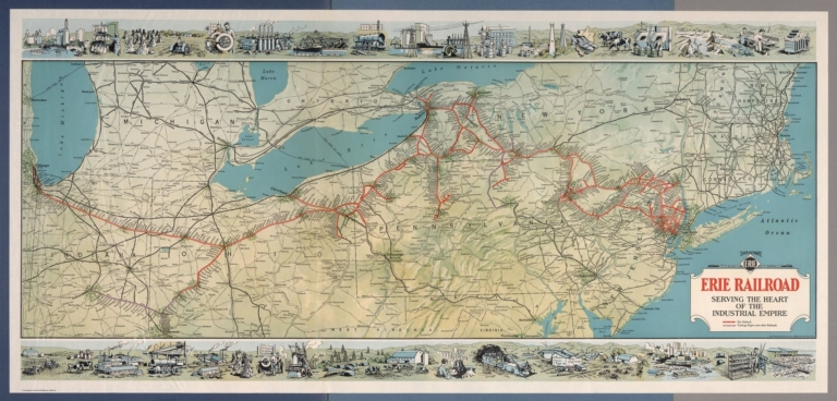
[Whitney-Graham Company, Inc., Erie Railroad Company]
Full Title
Ship and travel by fast Erie Service. Erie Railroad serving the heart of industrial empire. (to accompany) The blue book of map making : America's map makers. R.W.C. The Whitney-Graham Co. Inc. (5 insets).
List No
11489.022
Note
Color map folded. Includes illustration of industry and agriculture on upper and lower panels. Map showing Erie Railroad and trackage rights over railroad in color. Also shows state boundaries, cities, towns and roads.
Author
Boucher, Lucien
Full Title
Christopher Colombus 1436-1506.
List No
12054.009
Author
Boucher, Lucien
Full Title
Marquis de La Fayette, 1757-1834.
List No
12054.010
Author
Boucher, Lucien
Full Title
Le General Pershing, 1917.
List No
12054.011
Author
Boucher, Lucien
Full Title
Charles A. Lindbergh, 21 May, 1927.
List No
12054.012
Author
Klitgaard, Kaj (1883-1953)
Full Title
Island of Manhattan from the Battery to 59th Street. Kaj Klitgaard.
List No
11160.000
Note
This is a very rare color pictorial map of Manhattan, New York. Extends from Battery to 59th St. Includes marvelous illustrations of pre-Depression manhattan. Date estimated. With numerous allegorical vignettes including: Vanderbilt Yacht / Dreaming of the 1928 Election; at the top right, there are portrait images of Al Smith (then Governor of New York) and James A. Reed (Senator from Missouri); Prohibition - the bottles in the water and "enforcement" vignette over the river at the top left; The Gilded Age - the delightful cornucopia vignettes locating the rich and not so rich; Zeppelin & Battle Ship, resembles the USS Los Angeles or the USS Shenandoah, battleship USS Texas; then subways, lines of the IRT, BMT, and elevated train system, churches, hotels, businesses, etc. Includes key at the lower right corner. Klitgaard was a Danish American author, painter, illustrator, educator, and master mariner (1888-1953). This appears to be his only pictorial map. There are many hidden themes and caricatures in this map to be discovered. Date is estimated based on the image of the USS Texas. She was modernized in 1925-26 (losing the cage-mast and one funnel) and then was based out of NYC in August 1927 (with thanks to Harry Newman for this information).
Author
Godwin, Harrison
Full Title
Map of San Francisco Showing Principal Streets and Places of Interest. Drawn by Harrison Godwin. (Copyright) Harrison Godwin, San Francisco, Calif., U.S.A. Schmidt Litho., Co. S.F." (insets) Map of San Francisco : Making some of the early historical events. (with) San Francisco Bay and vicinity.
List No
8102.000
Note
Godwin's map is perhaps the largest and most profusely illustrated of all pictorial maps of San Francisco, with comic characters depicting different aspects of the city, a cowboy getting bucked off a horse, a couple dancing an exaggerated Charleston, dozens of whimsical vignettes with explanation text, illustrating both the modern city of San Francisco and its early history, including 1906 San Francisco's Earthquake and Fire. The streets, parks, local churches, schools, and government buildings are drawn to show the visitor. Noted: "The City That Knows How" and "The Ideal Convention City." Includes San Francisco: population, industry, products and postal services, and lists of banks and theaters.
Author
Geodezicheskii komitet VSNKh-SSSR
Full Title
Moskva i okrestnosti. Geodezicheskii komitet VSNKh-SSSR. 1927. (by) V. Savickij and M. Kallej.
List No
8681.000
Note
Color topographic map of Moscow and vicinity. Dissected into 36 sections, mounted on cloth, folded into 23x21, divided into 3 lists, each numbered: N-37-3-b, N-37-4-A, N-38-4-b, with location map on lower margin. No. 3 on upper right margin. Published by the Geodezicheskii komitet VSNKh-SSSR 1922- 1925. reprinted 1927. Includes key to symbols, legend and text. Relief shown by contours and spot heights.
Author
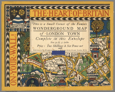
Gill, Leslie MacDonald, 1884-1947
Full Title
(Covers to) The Wonderground Map of London Town. Drawn by MacDonald Gill. Printed and Published by the Westminster Press, 11 Henrietta Street, Covent Garden, London, W.C.
List No
6755.001
Note
Cover is an illustrated envelope which reads, "The Heart of Britain on Your Wall. This is a Small Corner of the Famous Wonderground Map of London Town, Complete in the Envelope ... Published by The Westminster Press, 11 Henrietta Street, Strand, London, W.C.2." Has blue sticker from Edward Stanford, Ltd., Cartographers to the King. Gill's map of the London underground railways is an important early example of 20th century pictorial maps. It influenced other cartographers and initiated a colorful period of pictorial mapmaking internationally. This is third and final state of this map, with the greyhound in the upper letter corner triangle above the "On to Wembley" sign (first state 1914, with only houses in the triangle, second state 1924, with the "On to Wembley" sign and lion instead of a greyhound).
Author
Gill, Leslie MacDonald, 1884-1947
Full Title
The Wonderground Map of London Town. Drawn by MacDonald Gill. Printed and Published by the Westminster Press, 11 Henrietta Street, Covent Garden, London, W.C.
List No
6755.002
Note
Cover is an illustrated envelope. Gill's map of the London underground railways is an important early example of 20th century pictorial maps. It influenced other cartographers and initiated a colorful period of pictorial mapmaking internationally. This is third and final state of this map, with the greyhound in the upper letter corner triangle above the "On to Wembley" sign (first state 1914, with only houses in the triangle, second state 1924, with the "On to Wembley" sign and lion instead of a greyhound).
Author
Geographic Educator
Full Title
Terrestrial Globe - 6" Dia. - Geographic Educator. New York, U.S.A. Printed in U.S.A. Copyright 1927.
List No
0296.000
Note
Opens up to reveal six sections in layers. The opening portions are like a puzzle, with the various states its pieces. Layers from bottom to top include: 1. Australia. 2. South America. 3. Africa. 4. Asia. 5. North America (with states delineated). 6. Europe. Total height from base to top of the globe is eleven inches. The globe itself is 5.5 inches.
Author
Godwin, Harrison
Full Title
Map of San Francisco Showing Principal Streets and Places of Interest. Drawn by Harrison Godwin. (Copyright) Harrison Godwin, San Francisco, Calif., U.S.A. Schmidt Litho., Co. S.F." (insets) Map of San Francisco : Making some of the early historical events. (with) San Francisco Bay and vicinity.
List No
10046.000
Note
This is a rare proof state of Godwin's San Francisco map (see our 8102.00 for the full color version). Godwin's map is perhaps the largest and most profusely illustrated of all pictorial maps of San Francisco, with comic characters depicting different aspects of the city, a cowboy getting bucked off a horse, a couple dancing an exaggerated Charleston, dozens of whimsical vignettes with explanation text, illustrating both the modern city of San Francisco and its early history, including 1906 San Francisco's Earthquake and Fire. The streets, parks, local churches, schools, and government buildings are drawn to show the visitor. Noted: "The City That Knows How" and "The Ideal Convention City." Includes San Francisco: population, industry, products and postal services, and lists of banks and theaters.
Author
[Morian, H.L., Hannaford, E.I., Fergie, H.A.B.]
Full Title
Fergie's New Commercial Map of Portland, Oregon, Compiled from Official Records on File in the Office of the City Engineer.
List No
10685.000
Note
Date estimated.
Author
[Routledge, Fred A., 1873-1936, California-Oregon-Washington Tourist Association]
Full Title
(Covers to) Copyrighted official map of the California - Oregon - Washington - Tourist Association. (insets) Grant pass Oregon. (with) Portland. (with) Seattle. (with) Tacoma. (cover title) One way folder map: Vancouver, B.C. to California State line. Map number 88 ... Grant Pass, Oregon. Courier Print, Grants Pass, Oregon.
List No
11129.001
Note
Uncolored map of the Pacific Northwest, 53x19, folded to 22x10. Shows paved roads, dirt roads, place names. Relief shown pictorially and spot heights. On verso: Text and "Official membership list". Includes logo of the Association of cover. Date estimated.
Author
[Routledge, Fred A., 1873-1936, California-Oregon-Washington Tourist Association]
Full Title
(Text Page to) Copyrighted official map of the California - Oregon - Washington - Tourist Association. (insets) Grant pass Oregon. (with) Portland. (with) Seattle. (with) Tacoma. (cover title) One way folder map: Vancouver, B.C. to California State line. Map number 88 ... Grant Pass, Oregon. Courier Print, Grants Pass, Oregon.
List No
11129.002
Note
Uncolored map of the Pacific Northwest, 53x19, folded to 22x10. Shows paved roads, dirt roads, place names. Relief shown pictorially and spot heights. On verso: Text and "Official membership list". Includes logo of the Association of cover. Date estimated.
Author
[Routledge, Fred A., 1873-1936, California-Oregon-Washington Tourist Association]
Full Title
Copyrighted official map of the California - Oregon - Washington - Tourist Association. (insets) Grant pass Oregon. (with) Portland. (with) Seattle. (with) Tacoma. (cover title) One way folder map: Vancouver, B.C. to California State line. Map number 88 ... Grant Pass, Oregon. Courier Print, Grants Pass, Oregon.
List No
11129.003
Note
Uncolored map of the Pacific Northwest, 53x19, folded to 22x10. Shows paved roads, dirt roads, place names. Relief shown pictorially and spot heights. On verso: Text and "Official membership list". Includes logo of the Association of cover. Date estimated.
Author
Drevenstedt, Amy
Full Title
The Flight of Charles A. Lindbergh from New York to Paris in his Mono Plane "The Spirit Of St. Louis" on May 20-21, 1927. (illustrated by) Amy Drevenstedt.
List No
11198.000
Note
Pictorial map of North America and Western Europe showing Charles Lindbergh’s famous and epic Transatlantic flight from New York across the Atlantic Ocean to Paris in a plane dubbed The Spirit of St. Louis. Library has colored and larger version of the map, see #8252.000. The left border depicts the preparations including the initial flight from San Diego to St. Louis and on to New York. The upper border illustrates the elements he braved: "Distance, Fog, Snow, Sleet, Darkness and Solitude.” The right border illustrates his destination including the airport in France and the triumphant reception in Paris and Brussels. The lower border depicts his return via the USS Memphis to a hero's greeting in Washington and New York. Relief shown by hachers.
Author
Rand McNally and Company
Full Title
(Covers to) Rand McNally junior auto road map : Pennsylvania. Copyright by Rand McNally & Co. Chicago, Ill. Made in U.S.A. I-9. (Cover title) Rand McNally junior auto road map. Complement of Motor Inn filling Stations. Bradford, PA. Irvine Mills, N.Y. Pennsylvania.
List No
11372.001
Note
Color map on sheets 30.5x45, folded in cover 12.5x8. Date estimated. Shows through routes, secondary connecting roads, state and U.S. highways, principal cities and mileage. Includes official markers.
Author
Rand McNally and Company
Full Title
Rand McNally junior auto road map : Pennsylvania. Copyright by Rand McNally & Co. Chicago, Ill. Made in U.S.A. I-9. (Cover title) Rand McNally junior auto road map. Complement of Motor Inn filling Stations. Bradford, PA. Irvine Mills, N.Y. Pennsylvania.
List No
11372.002
Note
Color map on sheets 30.5x45, folded in cover 12.5x8. Date estimated. Shows through routes, secondary connecting roads, state and U.S. highways, principal cities and mileage. Includes official markers.
Author
Rand McNally and Company
Full Title
(Covers to) Rand McNally junior auto road map : New York. Copyright by Rand McNally & Co. Chicago, Ill. Made in U.S.A. I-25. (Cover title) Official road map of New York State. Western Pennsylvania, Ohio, southern Michigan and southern Ontario with Eastern United States Mileage table. Texaco. Goodyear - Wende Oil Corporation, Buffalo, New York. (on verso) Eastern United States Mileage table. (inset) Lowe New York : Long Island.
List No
11373.001
Note
Color map on sheets 31x45, folded in cover 13x8. Date estimated. Shows through routes, secondary connecting roads, state and U.S. highways, principal cities, ferries and boat lines. Includes official markers. On verso: Map and mileage table.
Author
Rand McNally and Company
Full Title
Rand McNally junior auto road map : New York. Copyright by Rand McNally & Co. Chicago, Ill. Made in U.S.A. I-25. (Cover title) Official road map of New York State. Western Pennsylvania, Ohio, southern Michigan and southern Ontario with Eastern United States Mileage table. Texaco. Goodyear - Wende Oil Corporation, Buffalo, New York. (on verso) Eastern United States Mileage table. (inset) Lowe New York : Long Island.
List No
11373.002
Note
Color map on sheets 31x45, folded in cover 13x8. Date estimated. Shows through routes, secondary connecting roads, state and U.S. highways, principal cities, ferries and boat lines. Includes official markers. On verso: Map and mileage table.
Author
Rand McNally and Company
Full Title
(Text Page to) Rand McNally junior auto road map : New York. Copyright by Rand McNally & Co. Chicago, Ill. Made in U.S.A. I-25. (Cover title) Official road map of New York State. Western Pennsylvania, Ohio, southern Michigan and southern Ontario with Eastern United States Mileage table. Texaco. Goodyear - Wende Oil Corporation, Buffalo, New York. (on verso) Eastern United States Mileage table. (inset) Lowe New York : Long Island.
List No
11373.003
Note
Color map on sheets 31x45, folded in cover 13x8. Date estimated. Shows through routes, secondary connecting roads, state and U.S. highways, principal cities, ferries and boat lines. Includes official markers. On verso: Map and mileage table.
Author
[Whitney-Graham Company, Inc., Central States Electric, Inc.]
Full Title
Properties of Central States Electric Company and associated companies. Public Utility Service. 10-27. (to accompany) The blue book of map making : America's map makers. R.W.C. The Whitney-Graham Co. Inc.
List No
11489.013
Note
Color map. Shows administrative divisions, major cities and towns, highlighting railways, electric and telephone companies, telephone lines, gas and hydro-electric stations, etc. Includes legend.
Author
[Whitney-Graham Company, Inc., New York Central Railroad Company]
Full Title
New York Central lines. 1927. (to accompany) The blue book of map making : America's map makers. R.W.C. The Whitney-Graham Co. Inc. (5 insets).
List No
11489.021
Note
Color map. Insets: Buffalo Niagara Fall and vicinity; Boston and vicinity; Chicago and vicinity; Cleveland and vicinity; New York city and vicinity. Map showing different railroad lines throughout the northeast and midwest in color. Also shows state boundaries, cities, towns and roads.
Author
[Bonner, Mary Graham, 1890-1974, Price, Luxor]
Full Title
(Contents to) The Magic Map, by Mary Graham Bonner, Illustrated by Luxor Price. New York, the Macaulay Company. Copyright, 1927, by the Macaulay Company. Printed in the United States of America.
List No
11562.007
Note
First edition of "The Magic Map" 1927, written by Mary Graham Bonner, teaching concepts of geography as fascinating and as adventurous as travel and actual exploration. Illustrated by Luxor Price in his distinctive style of map making and yet are full of whimsical fun and fact. It introduced young people to the fun of learning geography by humanizing in his illustrations the Atlantic Ocean, Latitude & Longitude, Cape Horn, etc. Published by the Macaulay Company in New York. In 238 pages of descriptive text with imprint on verso of title page and 16 illustrations, printed in blue and black. Includes colorful frontispiece and dust jacket depicting North and South America as people between oceans filled with peculiar fish. Includes flap text on the inside front and back of the dust jacket. Bound in orange cloth hard cover boards with black lettering and illustrations on the front board and spine. Illustrated end paper in black, white, and aqua, signed by Luxor Price affixed to the front and back, with inscription dated Dec. 25, 1930 in the front.
Author
[Bonner, Mary Graham, 1890-1974, Price, Luxor]
Full Title
(Contents to) The Magic Map, by Mary Graham Bonner, Illustrated by Luxor Price. New York, the Macaulay Company. Copyright, 1927, by the Macaulay Company. Printed in the United States of America.
List No
11562.008
Note
First edition of "The Magic Map" 1927, written by Mary Graham Bonner, teaching concepts of geography as fascinating and as adventurous as travel and actual exploration. Illustrated by Luxor Price in his distinctive style of map making and yet are full of whimsical fun and fact. It introduced young people to the fun of learning geography by humanizing in his illustrations the Atlantic Ocean, Latitude & Longitude, Cape Horn, etc. Published by the Macaulay Company in New York. In 238 pages of descriptive text with imprint on verso of title page and 16 illustrations, printed in blue and black. Includes colorful frontispiece and dust jacket depicting North and South America as people between oceans filled with peculiar fish. Includes flap text on the inside front and back of the dust jacket. Bound in orange cloth hard cover boards with black lettering and illustrations on the front board and spine. Illustrated end paper in black, white, and aqua, signed by Luxor Price affixed to the front and back, with inscription dated Dec. 25, 1930 in the front.
Author
Sha Kinran
Full Title
Sugoroku : Speed contest of around the world. Kinran Sha. Taisho era 16th. (1927).
List No
11828.000
Note
1926 board game pictorial map of the world. Supplement of King new year special bumper issue, Japanese around the world adventure story propaganda. Sugoroku is a Japanese children's game that has been popular since the Meiji period (c.1868). Map shows political boundaries, major cities, vignettes representing various landmarks. Relief shown pictorially.
Author
[Weiss, Pierre, Boucher, Lucien]
Full Title
(Covers to) Trans-Atlantic from Christopher Colombus to Charles A. Lindbergh.
List No
12054.001
Note
Beige paper cover with orange string binding. Blue label on front with text in French from original edition, reading: "Atlantique" in white. Has pockets front and back for the maps. Original French edition was printed in 1927; this English edition, presented in 1937, may have been printed for the 10th anniversary or previously. "Copy Specially Printed for Isaac S. Moore". Bookseller and other information has been blacked out. Translated by Quex. With four exquisite maps by Lucien Boucher.
Author
[Weiss, Pierre, Boucher, Lucien]
Full Title
(Half Title Page) Trans-Atlantic.
List No
12054.002
Note
Includes presentation text.
Author
[Weiss, Pierre, Boucher, Lucien]
Full Title
(Half Title Page Verso) 1000 copies ....
List No
12054.003
Note
Includes 'printed for' text.
Author
[Weiss, Pierre, Boucher, Lucien]
Full Title
(Title Page) Trans-Atlantic from Christopher Colombus to Charles A. Lindbergh.
List No
12054.004
Note
Includes 'printed for' text.
Author
Weiss, Pierre
Full Title
(Text Page) Trans-Atlantic from Christopher Colombus to Charles A. Lindbergh.
List No
12054.005
Author
Weiss, Pierre
Full Title
(Text Page) Trans-Atlantic from Christopher Colombus to Charles A. Lindbergh (continued).
List No
12054.006
Author
Weiss, Pierre
Full Title
(Text Page) Trans-Atlantic from Christopher Colombus to Charles A. Lindbergh (continued).
List No
12054.007
Author
Weiss, Pierre
Full Title
(Text Page) Trans-Atlantic from Christopher Colombus to Charles A. Lindbergh (continued).
List No
12054.008
Author
Waugh, Coulton, 1896-1973
Full Title
Cape Ann and the North Shore. A map displaying the hardy maritime development of these historic parts.
List No
12323.000
Author
[U. S. General Land Office, General Land Office]
Full Title
State of New Mexico. General Land Office.
List No
12410.000
Author
Gordenier, W.H.
Full Title
Map showing route of the Lewis & Clark Expedition 1804-1806.
List No
12414.000
Note
Also shows route of the Great Northern Railway.
Author
Shearman, Warren C.
Full Title
Chart South American Cruise on ye Good Shippe "Laconia". Raymond & Whitcomb Co. Anno 1927. A Mappe Shewing ye Course - ports of Call of ye S.S. "Laconia" ... by Warren C. Shearman.
List No
12415.000
Author
Kroll Map Company, inc.
Full Title
(Covers to) Standard map of the Territory of Alaska. Compiled from latest government surveys land with the assistance of prominent Alaska men. Published by Kroll Map Company. Seattle, Washington. Copyright 1927. (inset) Aleutian Islands.
List No
13014.001
Note
Color map of Alaska on sheet 68x86, folded into pictorial covers 17x11, with title "Map of Alaska". Shows international and judicial boundaries, major cities, towns, roads, railroads, trails, public buildings, mineral resources, steamship routes, glaciers, cable lines, etc. Airplane landing fields and airplane established routes shown in red. Relief shown by hachures and spot heights. Includes statistical table inside front cover. Index and distance table on verso.
Author
Kroll Map Company, inc.
Full Title
(Index Page to) Standard map of the Territory of Alaska. Compiled from latest government surveys land with the assistance of prominent Alaska men. Published by Kroll Map Company. Seattle, Washington. Copyright 1927. (inset) Aleutian Islands.
List No
13014.002
Note
Color map of Alaska on sheet 68x86, folded into pictorial covers 17x11, with title "Map of Alaska". Shows international and judicial boundaries, major cities, towns, roads, railroads, trails, public buildings, mineral resources, steamship routes, glaciers, cable lines, etc. Airplane landing fields and airplane established routes shown in red. Relief shown by hachures and spot heights. Includes statistical table inside front cover. Index and distance table on verso.
Author
Kroll Map Company, inc.
Full Title
Standard map of the Territory of Alaska. Compiled from latest government surveys land with the assistance of prominent Alaska men. Published by Kroll Map Company. Seattle, Washington. Copyright 1927. (inset) Aleutian Islands.
List No
13014.003
Note
Color map of Alaska on sheet 68x86, folded into pictorial covers 17x11, with title "Map of Alaska". Shows international and judicial boundaries, major cities, towns, roads, railroads, trails, public buildings, mineral resources, steamship routes, glaciers, cable lines, etc. Airplane landing fields and airplane established routes shown in red. Relief shown by hachures and spot heights. Includes statistical table inside front cover. Index and distance table on verso.
Author
Wardell, Ray
Full Title
The Quest of the Goodly Knights. Ray Wardell. (Copyright) 1927 by National Child Welfare Association Inc. New York City.
List No
13184.000
Note
Pictorial map of the pathway to "The Castle of Knighthood," issued by The National Child Welfare Association which was founded in New York in 1912. An article by Charles F. Powlison, the General Secretary of the organization notes: "Pictures will attract and hold the attention of children who are too restless and lively to absorb ideas through less striking mediums ..." Includes decorative title cartouche and border.
Author
Fitch, Lillian McKinstry
Full Title
Ye Newe-fangled Mappe of Ye Olde College Towne : Northwestern University. Copyright 1927 by Lillian McKinstry Fitch.
List No
13276.000
Note
Pictorial map, was drawn by Lillian McKinstry Fitch. Showing notations, including a hand signature in the lower-left, 1926 Conference Champions tower by Dyche Stadium, street names, buildings, intersections, fraternity houses,stadium, etc. Includes the University seal and compass rose.
Author
Ikbal Kutuphanesi Sahibi Huseyin
Full Title
Avrupa = Europe. Katabikhanih Ikbal. (to accompany) Tajadud maktab atlasi = New school atlas. 1927-1345.
List No
13435.005
Note
Political map of Europe. Shows capitals and major cities.
Author
Ikbal Kutuphanesi Sahibi Huseyin
Full Title
Asiya = Asia. (to accompany) Tajadud maktab atlasi = New school atlas. 1927-1345.
List No
13435.006
Note
Political map of Asia. Shows capitals and major cities.
Author
Ikbal Kutuphanesi Sahibi Huseyin
Full Title
Afrika = Africa. (to accompany) Tajadud maktab atlasi = New school atlas. 1927-1345.
List No
13435.007
Note
Political map of Africa. Shows capitals and major cities.
Author
Ikbal Kutuphanesi Sahibi Huseyin
Full Title
Somali Aamerika = North America. (to accompany) Tajadud maktab atlasi = New school atlas. 1927-1345.
List No
13435.008
Note
Political map. Shows capitals and major cities. Shows Central America and part of South America.
Author
Ikbal Kutuphanesi Sahibi Huseyin
Full Title
Janubii Aamerika = South America. (to accompany) Tajadud maktab atlasi = New school atlas. 1927-1345.
List No
13435.009
Note
Political map. Shows capitals and major cities.
Author
Ikbal Kutuphanesi Sahibi Huseyin
Full Title
Okyanusya = Oceania. Katabikhanih Ikbal. (to accompany) Tajadud maktab atlasi = New school atlas. 1927-1345.
List No
13435.010
Note
Political map of Oceania. Shows capitals and major cities.
Author
Ikbal Kutuphanesi Sahibi Huseyin
Full Title
Balkan hukumetliri = Balkan Governments. Katabikhanih Ikbal. (to accompany) Tajadud maktab atlasi = New school atlas. 1927-1345.
List No
13435.012
Note
Political map of Balkan States. Shows capitals and major cities.
Author
Ikbal Kutuphanesi Sahibi Huseyin
Full Title
Kavkasieh = Caucasus. Katabikhanih Ikbal. (to accompany) Tajadud maktab atlasi = New school atlas. 1927-1345.
List No
13435.013
Note
Political map of Caucasus. Shows political boundaries, capitals and major cities.
Author
[Hickmann, Anton Leo, 1834-1906, Fischer, Alois, b. 1894]
Full Title
(Text Page to) Prof. Hickmann's Geographisch-statistischer universal-atlas, 1927. Vollständig neubearbeitet von Alois Fischer. Druck u. verlag der kartographischen anstalt G. Freytag & Berndt A.G., Wien.
List No
13687.003
Note
Forward by Alois Fischer. Wien, in Oktober 1926.
Author
[Hickmann, Anton Leo, 1834-1906, Fischer, Alois, b. 1894]
Full Title
(Text Page to) Prof. Hickmann's Geographisch-statistischer universal-atlas, 1927. Vollständig neubearbeitet von Alois Fischer. Druck u. verlag der kartographischen anstalt G. Freytag & Berndt A.G., Wien.
List No
13687.004
Note
Title with 79 pages of text.
Author
[Hickmann, Anton Leo, 1834-1906, Fischer, Alois, b. 1894]
Full Title
Die Volkerverbreitung auf der erde. G. Freytag & Berndt A.G., Wien. (to accompany) Prof. Hickmann's Geographisch-statistischer universal-atlas, 1927.
List No
13687.013
Note
Folded map showing distribution of peoples in the world. Includes color explanation of nationalities and races.
Author
[Hickmann, Anton Leo, 1834-1906, Fischer, Alois, b. 1894]
Full Title
Religionskarte der erde. G. Freytag & Berndt A.G., Wien. (to accompany) Prof. Hickmann's Geographisch-statistischer universal-atlas, 1927.
List No
13687.014
Note
Folded map showing distribution of religions in the world. Includes color explanation of Principal Regions in the world.
Author
[Hickmann, Anton Leo, 1834-1906, Fischer, Alois, b. 1894]
Full Title
Europa. G. Freytag & Berndt A.G., Wien. (to accompany) Prof. Hickmann's Geographisch-statistischer universal-atlas, 1927.
List No
13687.015
Note
Political map of Europe. Showing political boundaries, cities, topography, bodies of water, drainage, coastlines, islands. railways, steamship routes and distances. Includes legend. Relief shown by hachures and spot heights. Prime meridian: Greenwich.
Author
[Hickmann, Anton Leo, 1834-1906, Fischer, Alois, b. 1894]
Full Title
Volker- u. Sprachenkarte von Europa. G. Freytag & Berndt A.G., Wien. (to accompany) Prof. Hickmann's Geographisch-statistischer universal-atlas, 1927.
List No
13687.016
Note
Linguistic map of Europe. Showing geographic distribution of principal languages. Includes color coded reference.
Author
[Hickmann, Anton Leo, 1834-1906, Fischer, Alois, b. 1894]
Full Title
Deutsches Reich. G. Freytag & Berndt A.G., Wien. (to accompany) Prof. Hickmann's Geographisch-statistischer universal-atlas, 1927.
List No
13687.017
Note
Political map of the German Empire. Capital of free stares are underlined. Relief shown by hachures. Prime meridian: Greenwich.
Author
[Hickmann, Anton Leo, 1834-1906, Fischer, Alois, b. 1894]
Full Title
Osterreich. G. Freytag & Berndt A.G., Wien. (to accompany) Prof. Hickmann's Geographisch-statistischer universal-atlas, 1927.
List No
13687.018
Note
Political map of Austria. Relief shown by hachures and spot heights.
Author
[Hickmann, Anton Leo, 1834-1906, Fischer, Alois, b. 1894]
Full Title
Tschecho-slowakei. G. Freytag & Berndt A.G., Wien. (to accompany) Prof. Hickmann's Geographisch-statistischer universal-atlas, 1927.
List No
13687.019
Note
Political map of Czechoslovakia, with inset map of Polen. Relief shown by hachures and spot heights.
Author
[Hickmann, Anton Leo, 1834-1906, Fischer, Alois, b. 1894]
Full Title
Schweiz. G. Freytag & Berndt A.G., Wien. (to accompany) Prof. Hickmann's Geographisch-statistischer universal-atlas, 1927.
List No
13687.020
Note
Political map of Switzerland. Relief shown by hachures and spot heights. Capitals are doubled and Canton capitals are single underlined.
Author
[Hickmann, Anton Leo, 1834-1906, Fischer, Alois, b. 1894]
Full Title
Italien. G. Freytag & Berndt A.G., Wien. (to accompany) Prof. Hickmann's Geographisch-statistischer universal-atlas, 1927.
List No
13687.021
Note
Political map of Italy. Relief shown by hachures and spot heights. Prime meridian: Greenwich.
Author
[Hickmann, Anton Leo, 1834-1906, Fischer, Alois, b. 1894]
Full Title
Spanien u. Portugal. G. Freytag & Berndt A.G., Wien. (to accompany) Prof. Hickmann's Geographisch-statistischer universal-atlas, 1927.
List No
13687.022
Note
Political map of Iberian Peninsula. Relief shown by hachures and spot heights. Prime meridian: Greenwich.
Author
[Hickmann, Anton Leo, 1834-1906, Fischer, Alois, b. 1894]
Full Title
Frankreich. G. Freytag & Berndt A.G., Wien. (to accompany) Prof. Hickmann's Geographisch-statistischer universal-atlas, 1927.
List No
13687.023
Note
Political map of France. Relief shown by hachures and spot heights. Prime meridian: Greenwich.
Author
[Hickmann, Anton Leo, 1834-1906, Fischer, Alois, b. 1894]
Full Title
Niederlande, Belgien und Luxemburg. G. Freytag & Berndt A.G., Wien. (to accompany) Prof. Hickmann's Geographisch-statistischer universal-atlas, 1927.
List No
13687.024
Note
Political map of Netherlands, Belgium and Luxembourg. Relief shown by hachures and spot heights. Prime meridian: Greenwich.
Author
[Hickmann, Anton Leo, 1834-1906, Fischer, Alois, b. 1894]
Full Title
Grossbritannien u. Irland. G. Freytag & Berndt A.G., Wien. (to accompany) Prof. Hickmann's Geographisch-statistischer universal-atlas, 1927.
List No
13687.025
Note
Political map of Great Britain and Ireland. Relief shown by hachures and spot heights. Prime meridian: Greenwich.
Author
[Hickmann, Anton Leo, 1834-1906, Fischer, Alois, b. 1894]
Full Title
Schweden, Norwegen und Danmark. G. Freytag & Berndt A.G., Wien. (to accompany) Prof. Hickmann's Geographisch-statistischer universal-atlas, 1927.
List No
13687.026
Note
Political map of Scandinavia. Relief shown by hachures and spot heights. Prime meridian: Greenwich.
Author
[Hickmann, Anton Leo, 1834-1906, Fischer, Alois, b. 1894]
Full Title
Polen und die Baltischen Länder. G. Freytag & Berndt A.G., Wien. (to accompany) Prof. Hickmann's Geographisch-statistischer universal-atlas, 1927.
List No
13687.027
Note
Political map of Baltic states. Relief shown by hachures and spot heights. Prime meridian: Greenwich.
Author
[Hickmann, Anton Leo, 1834-1906, Fischer, Alois, b. 1894]
Full Title
Politische Einteilung der Union der Sowjetrepubliken. G. Freytag & Berndt A.G., Wien. (to accompany) Prof. Hickmann's Geographisch-statistischer universal-atlas, 1927.
List No
13687.028
Note
Political division map of the Union of Soviet Republic, including I. Russia, II. Ukraine, III. Belarus, IV. Transcaucasia.
Author
[Hickmann, Anton Leo, 1834-1906, Fischer, Alois, b. 1894]
Full Title
Südost-Europa (Nördlicher Teil). G. Freytag & Berndt A.G., Wien. (to accompany) Prof. Hickmann's Geographisch-statistischer universal-atlas, 1927.
List No
13687.029
Note
Political division map of Southeast Europe (Northern part), consisting primarily of the Balkans. Sovereign states and territories.
Author
[Hickmann, Anton Leo, 1834-1906, Fischer, Alois, b. 1894]
Full Title
Südosteuropa (Südlicher Teil). G. Freytag & Berndt A.G., Wien. (to accompany) Prof. Hickmann's Geographisch-statistischer universal-atlas, 1927.
List No
13687.030
Note
Political division map of Southeast Europe (Southern part), consisting primarily of the Balkans. Sovereign states and territories.
Author
[Hickmann, Anton Leo, 1834-1906, Fischer, Alois, b. 1894]
Full Title
(Composite Map) Südosteuropa. G. Freytag & Berndt A.G., Wien. (to accompany) Prof. Hickmann's Geographisch-statistischer universal-atlas, 1927.
List No
13687.031
Note
Political division map of Southeast Europe (Northern and Southern parts), consisting primarily of the Balkan countries, Sovereign states and territories. Albania, Bosnia and Herzegovina, Bulgaria, Croatia, Cyprus, Greece, Kosovo, Montenegro, North Macedonia, Romania, Serbia and Turkey.
Author
[Hickmann, Anton Leo, 1834-1906, Fischer, Alois, b. 1894]
Full Title
Süd-Amerika. G. Freytag & Berndt A.G., Wien. (to accompany) Prof. Hickmann's Geographisch-statistischer universal-atlas, 1927.
List No
13687.037
Note
Political map of South America, with inset map of Antarktis (Antarctic regions). Includes color reference to European possessions. Relief shown by hachures and spot heights. Prime meridian: Greenwich.
Author
[Hickmann, Anton Leo, 1834-1906, Fischer, Alois, b. 1894]
Full Title
Mitteres Süd-Amerika. G. Freytag & Berndt A.G., Wien. (to accompany) Prof. Hickmann's Geographisch-statistischer universal-atlas, 1927.
List No
13687.038
Note
Political map of South America. Includes legend. Relief shown by hachures and spot heights. Prime meridian: Greenwich.
Author
[Hickmann, Anton Leo, 1834-1906, Fischer, Alois, b. 1894]
Full Title
Australien und Ozeanien. G. Freytag & Berndt A.G., Wien. (to accompany) Prof. Hickmann's Geographisch-statistischer universal-atlas, 1927.
List No
13687.039
Note
Map of Australia and Oceania, with inset of continuation of map. Includes legend. Relief shown by hachures and spot heights. Prime meridian: Greenwich.
Author
[Hickmann, Anton Leo, 1834-1906, Fischer, Alois, b. 1894]
Full Title
Vergleichende lange der öffentlichen eisenbahnlinien in Kilometern (1920). G. Freytag & Berndt A.G., Wien. (to accompany) Prof. Hickmann's Geographisch-statistischer universal-atlas, 1927.
List No
13687.057
Note
Statistical tables. Showing comparative length of public railway lines in kilometers in 1920.
Author
[Hickmann, Anton Leo, 1834-1906, Fischer, Alois, b. 1894]
Full Title
Erzeugung von elektrischer Energie 1924. G. Freytag & Berndt A.G., Wien. (to accompany) Prof. Hickmann's Geographisch-statistischer universal-atlas, 1927.
List No
13687.058
Note
Statistical tables. Showing electrical energy generation in billion kWh. Fully electric railways in some major countries.
Author
[Hickmann, Anton Leo, 1834-1906, Fischer, Alois, b. 1894]
Full Title
Anzahl der beförderten postsendungen in den wichtigsten landern ser Erde. G. Freytag & Berndt A.G., Wien. (to accompany) Prof. Hickmann's Geographisch-statistischer universal-atlas, 1927.
List No
13687.060
Note
Statistical diagrams. Showing number of mail items transported in the most important countries in the world.
Author
[Hickmann, Anton Leo, 1834-1906, Fischer, Alois, b. 1894]
Full Title
Vergleichende länge der Binnenschiffahrtsstraßen. G. Freytag & Berndt A.G., Wien. (to accompany) Prof. Hickmann's Geographisch-statistischer universal-atlas, 1927.
List No
13687.062
Note
Statistical tables. Comparing length of inland waterways. Including tables, text and inset maps of Suez Canal, Panama Canal and Kiel Canal.
Author
[Hickmann, Anton Leo, 1834-1906, Fischer, Alois, b. 1894]
Full Title
Seeverkehr der wichtigsten länder. G. Freytag & Berndt A.G., Wien. (to accompany) Prof. Hickmann's Geographisch-statistischer universal-atlas, 1927.
List No
13687.064
Note
Statistical table. Showing maritime transportation of the main countries in the world.
Author
[Hickmann, Anton Leo, 1834-1906, Fischer, Alois, b. 1894]
Full Title
Luftverkehr. G. Freytag & Berndt A.G., Wien. (to accompany) Prof. Hickmann's Geographisch-statistischer universal-atlas, 1927.
List No
13687.065
Note
Air traffic map of the world on folded sheet. "Imperial Airways". with 6 insets and text. Air routes shown in red lines.
Author
[Hickmann, Anton Leo, 1834-1906, Fischer, Alois, b. 1894]
Full Title
Die Gressfunkstationen der Erde (1925). G. Freytag & Berndt A.G., Wien. (to accompany) Prof. Hickmann's Geographisch-statistischer universal-atlas, 1927.
List No
13687.066
Note
Communication map of the world on folded sheets. Including major radio stations of the world. Inset text and graphs, showing coastal stations for public transport.
Author
[Hickmann, Anton Leo, 1834-1906, Fischer, Alois, b. 1894]
Full Title
Karte der wichtigsten grosshandlesmessen. G. Freytag & Berndt A.G., Wien. (to accompany) Prof. Hickmann's Geographisch-statistischer universal-atlas, 1927.
List No
13687.067
Note
Map of the major wholesale trades in Europe, with inset map of trades in non European countries and table of Leipzig trade fair, 1919-24.
Author
[Hickmann, Anton Leo, 1834-1906, Fischer, Alois, b. 1894]
Full Title
Die Konkurrenzverhältnisse auf dem weltmarkt 1913 u. 1923. G. Freytag & Berndt A.G., Wien. (to accompany) Prof. Hickmann's Geographisch-statistischer universal-atlas, 1927.
List No
13687.068
Note
Statistical tables. Competitive conditions on the world market in 1913 and 1923.
Author
[Hickmann, Anton Leo, 1834-1906, Fischer, Alois, b. 1894]
Full Title
Bewegung der Devisenkurse in New York 1922-1923. Goldwert der fremden devisen in New York in Monatsmittle Dezember 1923. G. Freytag & Berndt A.G., Wien. (to accompany) Prof. Hickmann's Geographisch-statistischer universal-atlas, 1927.
List No
13687.069
Note
Folded statistical diagrams and Tables. Showing movement of exchange rates in New York 1922-1923. Table showing gold value of foreign exchange in New York in mid-month December 1923.
Author
[Hickmann, Anton Leo, 1834-1906, Fischer, Alois, b. 1894]
List No
13687.070
Note
2 Statistical graphs and Tables. Showing movement of world market price levels 1913-1923. And commodity prices in the United States of America
Author
[Hickmann, Anton Leo, 1834-1906, Fischer, Alois, b. 1894]
Full Title
Internationale lebenshaltungsindexziffern Dezember 1923. G. Freytag & Berndt A.G., Wien. (to accompany) Prof. Hickmann's Geographisch-statistischer universal-atlas, 1927.
List No
13687.071
Note
3 Statistical graphs and Tables. Showing International livelihood index figures December 1923. Graphs showing Development of the cost of living in the United States of America 1913-923, and purchasing power of gold in the world.
Author
[Hickmann, Anton Leo, 1834-1906, Fischer, Alois, b. 1894]
Full Title
Goldwert der fremden devisen in New York in Monatsmittle Dezember 1923. G. Freytag & Berndt A.G., Wien. (to accompany) Prof. Hickmann's Geographisch-statistischer universal-atlas, 1927.
List No
13687.072
Note
Statistical graphs and Tables. Showing gold value of foreign exchange in New York. Graph showing movement in the rate of major unstable currencies in New York in 1924-25.
Author
[Hickmann, Anton Leo, 1834-1906, Fischer, Alois, b. 1894]
Full Title
Internationale Grosshandel Indexziffern 1913-24. Internationale Lebenshaltungsindexziffern 1914-1924. G. Freytag & Berndt A.G., Wien. (to accompany) Prof. Hickmann's Geographisch-statistischer universal-atlas, 1927.
List No
13687.073
Note
Statistical tables. Showing international financial statistics and data by country, including: Wholesale index figures 1913-24 and cost of living index by country 1914-1924.
Author
[Hickmann, Anton Leo, 1834-1906, Fischer, Alois, b. 1894]
Full Title
Löhne und Gehalte I. G. Freytag & Berndt A.G., Wien. (to accompany) Prof. Hickmann's Geographisch-statistischer universal-atlas, 1927.
List No
13687.074
Note
Statistical tables. Part I: wages and salaries by countries 1923-24.
Author
[Hickmann, Anton Leo, 1834-1906, Fischer, Alois, b. 1894]
Full Title
Löhne und Gehalte II. G. Freytag & Berndt A.G., Wien. (to accompany) Prof. Hickmann's Geographisch-statistischer universal-atlas, 1927.
List No
13687.075
Note
Statistical tables. Part II: wages and salaries by countries 1923-24. With charts showing weekly wages of metal workers and monthly salary of civilian servants in 1925
Author
[Hickmann, Anton Leo, 1834-1906, Fischer, Alois, b. 1894]
Full Title
Notenbankwesen. G. Freytag & Berndt A.G., Wien. (to accompany) Prof. Hickmann's Geographisch-statistischer universal-atlas, 1927.
List No
13687.076
Note
3 Statistical tables and diagrams. Central banking: official gold status at the end of 1913 and the end of 1923. Note circulation 1913-23. Official discount rates in July 1926.
Author
[Hickmann, Anton Leo, 1834-1906, Fischer, Alois, b. 1894]
Full Title
Nationalvermögen wichtiger länder 1914. G. Freytag & Berndt A.G., Wien. (to accompany) Prof. Hickmann's Geographisch-statistischer universal-atlas, 1927.
List No
13687.077
Note
Statistical diagrams: National assets of major countries 1914.
Author
[Hickmann, Anton Leo, 1834-1906, Fischer, Alois, b. 1894]
Full Title
Zur frage der internationalen verschuldung. G. Freytag & Berndt A.G., Wien. (to accompany) Prof. Hickmann's Geographisch-statistischer universal-atlas, 1927.
List No
13687.078
Note
Statistical diagrams: showing international depth in major countries. Includes explanation.
Author
[Hickmann, Anton Leo, 1834-1906, Fischer, Alois, b. 1894]
Full Title
Die fortdauernde weltwirtschaftskrise (Daten fur 1922 und 1923). G. Freytag & Berndt A.G., Wien. (to accompany) Prof. Hickmann's Geographisch-statistischer universal-atlas, 1927.
List No
13687.079
Note
Statistical diagrams: showing Great depression dated 1922-23.
Author
Neurath, Otto, 1882-1945
Full Title
Wanderbewegung wichtiger Länder 1920-27. Angefertigt für das Bibliographische Institut AG., Leipzig. Gesellschafts- und Wirtschaftsmuseum in Wien. ©
List No
14080.077
Note
Colored diagram, comparing migration across the world, from 1920 to 1927. Includes a legend and explanatory text. Diagram is 38 x 25 cm, on sheet 46 x 31 cm. Information depicted with Isotype (International system of typographic picture education), a method for assembling, configuring and disseminating information and statistics through pictorial means, invented by Otto and Marie Neurath.
Author
Statistischen Reichsamt
Full Title
Landwirtschaftliche Nutzfläche im Verhältnis zur Gesamtfläche.
List No
14371.032
Note
Map of the German Empire, featuring agricultural land in proportion to the total land area in 1927, based upon the Bodenbenutzungserhebung [Land use survey]. Also shows political boundaries, regions, routes, bodies of water, drainage, coastline and islands. Includes a legend and explanatory notes. Colored lithograph. Map is 31 x 41 cm, on sheet 37 x 45 cm.
Author
Statistischen Reichsamt
Full Title
Ackerland im Verhältnis zur Gesamtfläche.
List No
14371.033
Note
Map of the German Empire, featuring arable land in proportion to the total land area in 1927, based upon the Bodenbenutzungserhebung [Land use survey]. Also shows political boundaries, regions, routes, bodies of water, drainage, coastline and islands. Includes a legend and explanatory notes. Colored lithograph. Map is 31 x 41 cm, on sheet 37 x 45 cm.
Author
Statistischen Reichsamt
Full Title
Wiesen im Verhältnis zur Gesamtfläche.
List No
14371.034
Note
Map of the German Empire, featuring meadows in proportion to the total land area in 1927, based upon the Bodenbenutzungserhebung [Land use survey]. Also shows political boundaries, regions, routes, bodies of water, drainage, coastline and islands. Includes a legend and explanatory notes. Colored lithograph. Map is 31 x 41 cm, on sheet 37 x 45 cm.
Author
Statistischen Reichsamt
Full Title
Viehweiden und Hutungen im Verhältnis zur Gesamtfläche.
List No
14371.035
Note
Map of the German Empire, featuring pastures and huts in proportion to the total land area in 1927, based upon the Bodenbenutzungserhebung [Land use survey]. Also shows political boundaries, regions, routes, bodies of water, drainage, coastline and islands. Includes a legend and explanatory notes. Colored lithograph. Map is 31 x 41 cm, on sheet 37 x 45 cm.
Author
Statistischen Reichsamt
Full Title
Grünland (Wiesen, Viehweiden einschl. Hutungen und Futterpflanzen) im Verhältnis zur Gesamtfläche.
List No
14371.036
Note
Map of the German Empire, featuring grasslands (meadows, pastures including huts and forage plants) in proportion to the total land area in 1927, based upon the Bodenbenutzungserhebung [Land use survey]. Also shows political boundaries, regions, routes, bodies of water, drainage, coastline and islands. Includes a legend and explanatory notes. Colored lithograph. Map is 31 x 41 cm, on sheet 37 x 45 cm.
Author
Statistischen Reichsamt
Full Title
Obstanlagen als Hauptnutzung im Verhältnis zur Gesamtfläche.
List No
14371.037
Note
Map of the German Empire, featuring orchards in proportion to the total land area in 1927, based upon the Bodenbenutzungserhebung [Land use survey]. Also shows political boundaries, regions, routes, bodies of water, drainage, coastline and islands. Includes a legend and explanatory notes. With inset map: Württemberg. Colored lithograph. Map is 31 x 41 cm, on sheet 37 x 45 cm.
Author
Statistischen Reichsamt
Full Title
Weinberge und Weingärten im Verhältnis zur Gesamtfläche.
List No
14371.038
Note
Map of the German Empire, featuring vineyards in proportion to the total land area in 1927, based upon the Bodenbenutzungserhebung [Land use survey]. Also shows political boundaries, regions, routes, bodies of water, drainage, coastline and islands. Includes a legend and explanatory notes. Colored lithograph. Map is 31 x 41 cm, on sheet 37 x 45 cm.
Author
Statistischen Reichsamt
Full Title
Unkultivierte Moorflächen im Verhältnis zur Gesamtfläche.
List No
14371.039
Note
Map of the German Empire, featuring uncultivated moor areas in proportion to the total land area in 1927, based upon the Bodenbenutzungserhebung [Land use survey]. Also shows political boundaries, regions, routes, bodies of water, drainage, coastline and islands. Includes a legend and explanatory notes. Colored lithograph. Map is 31 x 41 cm, on sheet 37 x 45 cm.
Author
Statistischen Reichsamt
Full Title
Öd- und Unland im Verhältnis zur Gesamtfläche.
List No
14371.040
Note
Map of the German Empire, featuring "wasteland" areas in proportion to the total land area in 1927, based upon the Bodenbenutzungserhebung [Land use survey]. Also shows political boundaries, regions, routes, bodies of water, drainage, coastline and islands. Includes a legend and explanatory notes. Colored lithograph. Map is 31 x 41 cm, on sheet 37 x 45 cm.
Author
Statistischen Reichsamt
Full Title
Getreideanbau (Roggen, Weizen, Spelz, Gerste, Hafer, Menggetreide) : Anbaufläche im Verhältnis zur Gesamtfläche.
List No
14371.041
Note
Map of the German Empire, featuring grain cultivation (rye, wheat, spelt, barley, oats, meslin) in proportion to the total land area in 1927, based upon the Bodenbenutzungserhebung [Land use survey]. Also shows political boundaries, regions, routes, bodies of water, drainage, coastline and islands. Includes a legend and explanatory notes. Colored lithograph. Map is 31 x 41 cm, on sheet 37 x 45 cm.
Author
Statistischen Reichsamt
Full Title
Roggen : Anbaufläche im Verhältnis zur Gesamtfläche.
List No
14371.042
Note
Map of the German Empire, featuring rye acreage in proportion to the total land area in 1927, based upon the Bodenbenutzungserhebung [Land use survey]. Also shows political boundaries, regions, routes, bodies of water, drainage, coastline and islands. Includes a legend and explanatory notes. Map indexed to indicate city locations. Colored lithograph. Map is 31 x 41 cm, on sheet 37 x 45 cm.
Author
Statistischen Reichsamt
Full Title
Weizen und Spelz : Anbaufläche im Verhältnis zur Gesamtfläche.
List No
14371.043
Note
Map of the German Empire, featuring wheat and spelt acreage in proportion to the total land area in 1927, based upon the Bodenbenutzungserhebung [Land use survey]. Also shows political boundaries, regions, routes, bodies of water, drainage, coastline and islands. Includes a legend and explanatory notes. Map indexed to indicate city locations. Colored lithograph. Map is 31 x 41 cm, on sheet 37 x 45 cm.
Author
Statistischen Reichsamt
Full Title
Wintergerste : Anbaufläche im Verhältnis zur Gesamtfläche.
List No
14371.044
Note
Map of the German Empire, featuring winter barley acreage in proportion to the total land area in 1927, based upon the Bodenbenutzungserhebung [Land use survey]. Also shows political boundaries, regions, routes, bodies of water, drainage, coastline and islands. Includes a legend and explanatory notes. Map indexed to indicate city locations. Colored lithograph. Map is 31 x 41 cm, on sheet 37 x 45 cm.
Author
Statistischen Reichsamt
Full Title
Sommergerste : Anbaufläche im Verhältnis zur Gesamtfläche.
List No
14371.045
Note
Map of the German Empire, featuring spring barley acreage in proportion to the total land area in 1927, based upon the Bodenbenutzungserhebung [Land use survey]. Also shows political boundaries, regions, routes, bodies of water, drainage, coastline and islands. Includes a legend and explanatory notes. Colored lithograph. Map is 31 x 41 cm, on sheet 37 x 45 cm.
Author
Statistischen Reichsamt
Full Title
Hafer : Anbaufläche im Verhältnis zur Gesamtfläche.
List No
14371.046
Note
Map of the German Empire, featuring oat acreage in proportion to the total land area in 1927, based upon the Bodenbenutzungserhebung [Land use survey]. Also shows political boundaries, regions, routes, bodies of water, drainage, coastline and islands. Includes a legend and explanatory notes. Colored lithograph. Map is 31 x 41 cm, on sheet 37 x 45 cm.
Author
Statistischen Reichsamt
Full Title
Kartoffeln : Anbaufläche im Verhältnis zur Gesamtfläche.
List No
14371.047
Note
Map of the German Empire, featuring potato acreage in proportion to the total land area in 1927, based upon the Bodenbenutzungserhebung [Land use survey]. Also shows political boundaries, regions, routes, bodies of water, drainage, coastline and islands. Includes a legend and explanatory notes. Colored lithograph. Map is 31 x 41 cm, on sheet 37 x 45 cm.
Author
Statistischen Reichsamt
Full Title
Zuckerrüben : Anbaufläche im Verhältnis zur Gesamtfläche.
List No
14371.048
Note
Map of the German Empire, featuring sugar beet acreage in proportion to the total land area in 1927, based upon the Bodenbenutzungserhebung [Land use survey]. Also shows political boundaries, regions, routes, bodies of water, drainage, coastline and islands. Includes a legend and explanatory notes. Colored lithograph. Map is 31 x 41 cm, on sheet 37 x 45 cm.
Author
Statistischen Reichsamt
Full Title
Runkelrüben : Anbaufläche im Verhältnis zur Gesamtfläche.
List No
14371.049
Note
Map of the German Empire, featuring beet acreage in proportion to the total land area in 1927, based upon the Bodenbenutzungserhebung [Land use survey]. Also shows political boundaries, regions, routes, bodies of water, drainage, coastline and islands. Includes a legend and explanatory notes. Colored lithograph. Map is 31 x 41 cm, on sheet 37 x 45 cm.
Author
Statistischen Reichsamt
Full Title
Klee : Anbaufläche im Verhältnis zur Gesamtfläche.
List No
14371.050
Note
Map of the German Empire, featuring clover acreage in proportion to the total land area in 1927, based upon the Bodenbenutzungserhebung [Land use survey]. Also shows political boundaries, regions, routes, bodies of water, drainage, coastline and islands. Includes a legend and explanatory notes. Colored lithograph. Map is 31 x 41 cm, on sheet 37 x 45 cm.
Author
Statistischen Reichsamt
Full Title
Luzerne : Anbaufläche im Verhältnis zur Gesamtfläche.
List No
14371.051
Note
Map of the German Empire, featuring alfalfa acreage in proportion to the total land area in 1927, based upon the Bodenbenutzungserhebung [Land use survey]. Also shows political boundaries, regions, routes, bodies of water, drainage, coastline and islands. Includes a legend and explanatory notes. Colored lithograph. Map is 31 x 41 cm, on sheet 37 x 45 cm.
Author
Statistischen Reichsamt
Full Title
Serradella : Anbaufläche im Verhältnis zur Gesamtfläche.
List No
14371.052
Note
Map of the German Empire, featuring serradella acreage in proportion to the total land area in 1927, based upon the Bodenbenutzungserhebung [Land use survey]. Also shows political boundaries, regions, routes, bodies of water, drainage, coastline and islands. Includes a legend and explanatory notes. Colored lithograph. Map is 31 x 41 cm, on sheet 37 x 45 cm.
Author
Statistischen Reichsamt
Full Title
Lupinen : Anbaufläche im Verhältnis zur Gesamtfläche.
List No
14371.053
Note
Map of the German Empire, featuring lupine acreage in proportion to the total land area in 1927, based upon the Bodenbenutzungserhebung [Land use survey]. Also shows political boundaries, regions, routes, bodies of water, drainage, coastline and islands. Includes a legend and explanatory notes. Colored lithograph. Map is 31 x 41 cm, on sheet 37 x 45 cm.
Author
Statistischen Reichsamt
Full Title
Erbsen : Anbaufläche im Verhältnis zur Gesamtfläche.
List No
14371.054
Note
Map of the German Empire, featuring pea acreage in proportion to the total land area in 1927, based upon the Bodenbenutzungserhebung [Land use survey]. Also shows political boundaries, regions, routes, bodies of water, drainage, coastline and islands. Includes a legend and explanatory notes. Colored lithograph. Map is 31 x 41 cm, on sheet 37 x 45 cm.
Author
Statistischen Reichsamt
Full Title
Gemüse in feldmäßiger Bestellung : Anbaufläche im Verhältnis zur Gesamtfläche.
List No
14371.055
Note
Map of the German Empire, featuring vegetable acreage in proportion to the total land area in 1927, based upon the Bodenbenutzungserhebung [Land use survey]. Also shows political boundaries, regions, routes, bodies of water, drainage, coastline and islands. Includes a legend and explanatory notes. Colored lithograph. Map is 31 x 41 cm, on sheet 37 x 45 cm.
Author
Statistischen Reichsamt
Full Title
Weißkohl : Anbaufläche im Verhältnis zur Gesamtfläche.
List No
14371.056
Note
Map of the German Empire, featuring white cabbage acreage in proportion to the total land area in 1927, based upon the Bodenbenutzungserhebung [Land use survey]. Also shows political boundaries, regions, routes, bodies of water, drainage, coastline and islands. Includes a legend and explanatory notes. Colored lithograph. Map is 31 x 41 cm, on sheet 37 x 45 cm.
Author
Statistischen Reichsamt
Full Title
Gespinstpflanzen (Flachs und Hanf) : Anbaufläche im Verhältnis zur Gesamtfläche.
List No
14371.057
Note
Map of the German Empire, featuring web crop (flax and hemp) acreage in proportion to the total land area in 1927, based upon the Bodenbenutzungserhebung [Land use survey]. Also shows political boundaries, regions, routes, bodies of water, drainage, coastline and islands. Includes a legend and explanatory notes. Colored lithograph. Map is 31 x 41 cm, on sheet 37 x 45 cm.
Author
Statistischen Reichsamt
Full Title
Hopfen : Anbaufläche im Verhältnis zur Gesamtfläche.
List No
14371.058
Note
Map of the German Empire, featuring hop acreage in proportion to the total land area in 1927, based upon the Bodenbenutzungserhebung [Land use survey]. Also shows political boundaries, regions, routes, bodies of water, drainage, coastline and islands. Includes a legend and explanatory notes. Colored lithograph. Map is 31 x 41 cm, on sheet 37 x 45 cm.
Author
Statistischen Reichsamt
Full Title
Getreidelagerhäuser, Schiffahrtswege und Getreideanbau.
List No
14371.102
Note
Map of the German Empire, featuring the locations of grain warehouses, shipping routes and grain cultivation in 1927, based upon the Mühlenerhebung [Mill survey]. Also shows political boundaries, regions, routes, bodies of water, drainage, coastline and islands. Includes a legend, as well as data visualization throughout map. Colored lithograph. Map is 31 x 41 cm, on sheet 37 x 45 cm.
Author
Statistischen Reichsamt
Full Title
Forsten und Holzungen im Verhältnis zur Gesamtfläche.
List No
14371.103
Note
Map of the German Empire, featuring forest lands and logging in relation to the total land area in 1927, based upon the Bodenbenutzungerhebung [Land use survey]. Also shows political boundaries, regions, routes, bodies of water, drainage, coastline and islands. Includes a legend and explanatory notes. Colored lithograph. Map is 31 x 41 cm, on sheet 37 x 45 cm.
Author
Statistischen Reichsamt
Full Title
Besitzverteilung der Forsten und Holzungen : Anteile an der Holzbodenfläche.
List No
14371.104
Note
Map of the German Empire, featuring the distribution of ownership of forests and logging - according to shares in the wood floor area - in 1927, based upon the Forststatistik [Forest statistics]. Also shows political boundaries, regions, routes, bodies of water, drainage, coastline and islands. Includes a legend, as well as data visualization throughout map. Colored lithograph. Map is 31 x 41 cm, on sheet 37 x 45 cm.
Author
Statistischen Reichsamt
Full Title
Staatsforsten (einschl. Staatsanteilsforsten).
List No
14371.105
Note
Map of the German Empire, featuring the distribution of state forests in 1927, based upon the Forststatistik [Forest statistics]. Also shows political boundaries, regions, routes, bodies of water, drainage, coastline and islands. Includes a legend and explanatory notes. Colored lithograph. Map is 31 x 41 cm, on sheet 37 x 45 cm.
Author
Statistischen Reichsamt
Full Title
Gemeinde-, Stiftungs- und Genossenschaftsforsten.
List No
14371.106
Note
Map of the German Empire, featuring the distribution of municipal, foundation and cooperative forests in 1927, based upon the Forststatistik [Forest statistics]. Also shows political boundaries, regions, routes, bodies of water, drainage, coastline and islands. Includes a legend and explanatory notes. Colored lithograph. Map is 31 x 41 cm, on sheet 37 x 45 cm.
Author
Statistischen Reichsamt
Full Title
Privatforsten (gebundener Besitz).
List No
14371.107
Note
Map of the German Empire, featuring the distribution of private forests under "tied" ownership in 1927, based upon the Forststatistik [Forest statistics]. Also shows political boundaries, regions, routes, bodies of water, drainage, coastline and islands. Includes a legend and explanatory notes. Colored lithograph. Map is 31 x 41 cm, on sheet 37 x 45 cm.
Author
Statistischen Reichsamt
Full Title
Privatforsten (freier Besitz).
List No
14371.108
Note
Map of the German Empire, featuring the distribution of private forests under "free" ownership in 1927, based upon the Forststatistik [Forest statistics]. Also shows political boundaries, regions, routes, bodies of water, drainage, coastline and islands. Includes a legend and explanatory notes. Colored lithograph. Map is 31 x 41 cm, on sheet 37 x 45 cm.
Author
Statistischen Reichsamt
Full Title
Laub- und Nadelwald : Anteile an der Holzbodenfläche.
List No
14371.109
Note
Map of the German Empire, featuring the distribution of deciduous and coniferous forests in 1927, based upon the Forststatistik [Forest statistics]. Also shows political boundaries, regions, routes, bodies of water, drainage, coastline and islands. Includes a legend, as well as data visualization throughout map. Colored lithograph. Map is 31 x 41 cm, on sheet 37 x 45 cm.
Author
Statistischen Reichsamt
Full Title
Eichen : Bestand im Verhältnis zur Gesamtfläche.
List No
14371.110
Note
Map of the German Empire, featuring oaks in relation to the total land area in 1927, based upon the Forststatistik [Forest statistics]. Also shows political boundaries, regions, routes, bodies of water, drainage, coastline and islands. Includes a legend, as well as data visualization throughout map. Colored lithograph. Map is 31 x 41 cm, on sheet 37 x 45 cm.
Author
Statistischen Reichsamt
Full Title
Rotbuchen und andere harte Laubhölzer : Bestand im Verhältnis zur Gesamtfläche.
List No
14371.111
Note
Map of the German Empire, featuring European beech and other hard deciduous trees in relation to the total land area in 1927, based upon the Forststatistik [Forest statistics]. Also shows political boundaries, regions, routes, bodies of water, drainage, coastline and islands. Includes a legend and explanatory notes. Colored lithograph. Map is 31 x 41 cm, on sheet 37 x 45 cm.
Author
Statistischen Reichsamt
Full Title
Kiefern : Bestand im Verhältnis zur Gesamtfläche.
List No
14371.112
Note
Map of the German Empire, featuring pines in relation to the total land area in 1927, based upon the Forststatistik [Forest statistics]. Also shows political boundaries, regions, routes, bodies of water, drainage, coastline and islands. Includes a legend and explanatory notes. Colored lithograph. Map is 31 x 41 cm, on sheet 37 x 45 cm.
Author
Statistischen Reichsamt
Full Title
Fichten und Tannen : Bestand im Verhältnis zur Gesamtfläche.
List No
14371.113
Note
Map of the German Empire, featuring spruces and firs in relation to the total land area in 1927, based upon the Forststatistik [Forest statistics]. Also shows political boundaries, regions, routes, bodies of water, drainage, coastline and islands. Includes a legend and explanatory notes. Colored lithograph. Map is 31 x 41 cm, on sheet 37 x 45 cm.
Author
Statistischen Reichsamt
Full Title
Einlünfte aus Land- und Forstwirtschaft je ha Nutfläche.
List No
14371.116
Note
Map of the German Empire, featuring the income from agriculture and forestry per hectare of usable area in 1927, based upon the Einkommensteuerveranlagung [Income tax assessment]. Also shows political boundaries, regions, routes, bodies of water, drainage, coastline and islands. Includes a legend. Colored lithograph. Map is 31 x 41 cm, on sheet 37 x 45 cm.
Author
Statistischen Reichsamt
Full Title
Umsatz der Landwirtschaft je ha landwirtschaftlicher Nutfläche.
List No
14371.118
Note
Map of the German Empire, featuring the turnover in agriculture per hectare of agricultural land in 1927, based upon the Umsatzsteuer [Value added tax]. Also shows political boundaries, regions, routes, bodies of water, drainage, coastline and islands. Includes a legend and explanatory note. Colored lithograph. Map is 31 x 41 cm, on sheet 37 x 45 cm.
Author
Statistischen Reichsamt
Full Title
Umsatz der Landwirtschaft je veranlagter Betrieb.
List No
14371.119
Note
Map of the German Empire, featuring the turnover in agriculture per assessed operation in 1927, based upon the Umsatzsteuer [Value added tax]. Also shows political boundaries, regions, routes, bodies of water, drainage, coastline and islands. Includes a legend and explanatory note. Colored lithograph. Map is 31 x 41 cm, on sheet 37 x 45 cm.
Author
[Confederazione generale dell'industria italiana, Associzaione fra le società italiane per azioni]
Full Title
Numero degli addetti agli esercizi industriali secondo i risultati del censimento industriale del 15 ottobre 1927.
List No
14403.010
Note
Chart showing the number of employees within industry in Italy, according to the results of the industrial census of October 15, 1927. Includes descriptive text. Colored lithograph, on sheet 21 x 29 cm.
Author
[Confederazione generale dell'industria italiana, Associzaione fra le società italiane per azioni]
Full Title
Numero degli addetti agli esercizi industriali nelle diverse province censimento industriale 15 ott 1927.
List No
14403.011
Note
Chart showing the number of employees within industry in the different provinces of Italy, according to the results of the industrial census of October 15, 1927. Includes descriptive text. Colored lithograph, on sheet 21 x 29 cm.
Author
[Confederazione generale dell'industria italiana, Associzaione fra le società italiane per azioni]
Full Title
Densità degli esercizi industriali nelle varie regioni d'Italia (censimento industriale 15-X-1927).
List No
14403.012
Note
Map showing the density of industry in the different regions of Italy, according to the results of the industrial census of October 15, 1927. Includes a legend and descriptive text. Colored lithograph. Map is 25 x 18 cm, on sheet 29 x 21 cm.
Author
[Confederazione generale dell'industria italiana, Associzaione fra le società italiane per azioni]
Full Title
Densità della popolazione industriali per ogni 10,000 abitanti de età superiore al 10 anni nelle varie regioni d'Italia (censimento industriale 15-X-1927).
List No
14403.013
Note
Map showing the density of the industrial population for every 10,000 inhabitants aged over 10 in the different regions of Italy , according to the results of the industrial census of October 15, 1927. Includes a legend. Colored lithograph. Map is 26 x 18 cm, on sheet 29 x 21 cm.
Author
[Confederazione generale dell'industria italiana, Associzaione fra le società italiane per azioni]
Full Title
Potenza (hp) dei motori originari installati nelle varie regioni distinti per categoria d'industria (censimento industriale 15 ott 1927).
List No
14403.014
Note
Chart showing the horsepower of the original engines used within various industries in the different regions of Italy, according to the results of the industrial census of October 15, 1927. Includes descriptive text. Colored lithograph, on sheet 21 x 29 cm.
Author
[Confederazione generale dell'industria italiana, Associzaione fra le società italiane per azioni]
Full Title
Industrie siderurgiche e metallurgiche : Numero operai.
List No
14403.025
Note
Chart showing the number of workers within the steel and metallurgical industries in Italy, from 1903 to 1927. Includes descriptive text. Colored lithograph, on sheet 21 x 29 cm.
Author
[Confederazione generale dell'industria italiana, Associzaione fra le società italiane per azioni]
Full Title
Industrie meccaniche : Numero operai.
List No
14403.029
Note
Chart showing the number of workers within the mechanical industry in Italy, from 1903 to 1927. Includes descriptive text. Colored lithograph, on sheet 21 x 29 cm.
Author
[Confederazione generale dell'industria italiana, Associzaione fra le società italiane per azioni]
Full Title
Industrie chimiche : Numero operai.
List No
14403.036
Note
Chart showing the number of workers within the chemical industry in Italy, from 1903 to 1927. Includes descriptive text. Colored lithograph, on sheet 21 x 29 cm.
Author
[Confederazione generale dell'industria italiana, Associzaione fra le società italiane per azioni]
Full Title
Industrie tessili : Numero operai.
List No
14403.044
Note
Chart showing the number of workers within the textile industry in Italy, from 1903 to 1927. Includes descriptive text. Colored lithograph, on sheet 21 x 29 cm.
|
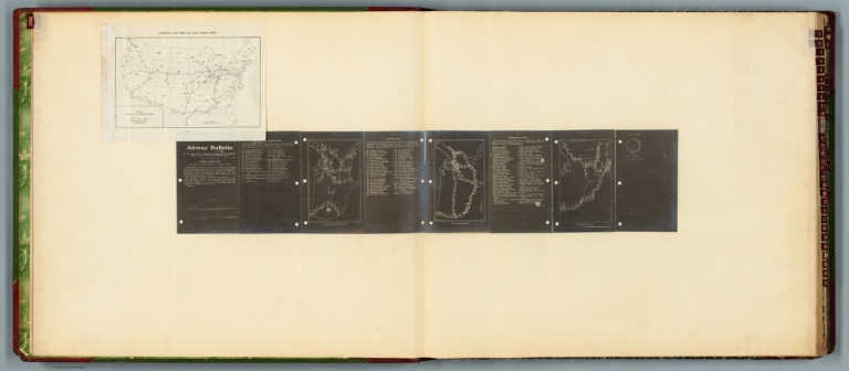
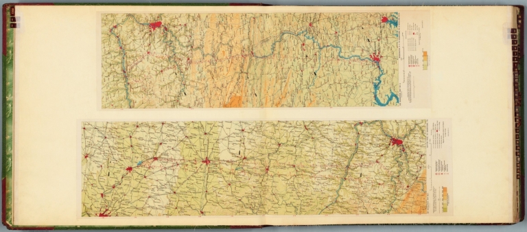
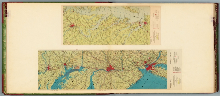
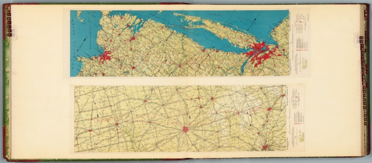
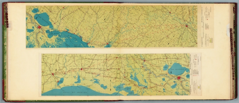
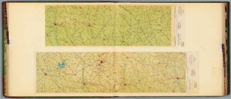
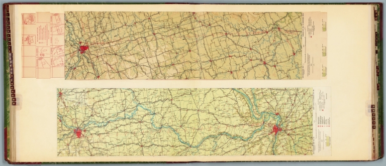
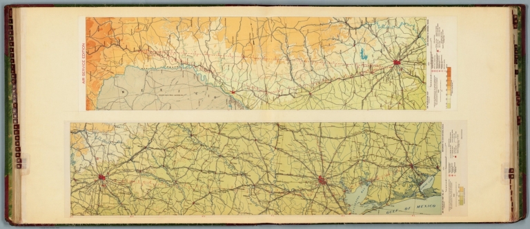
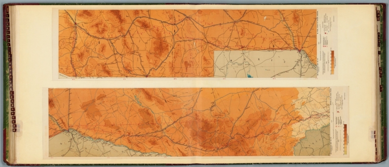
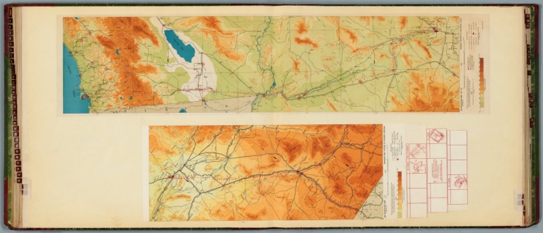
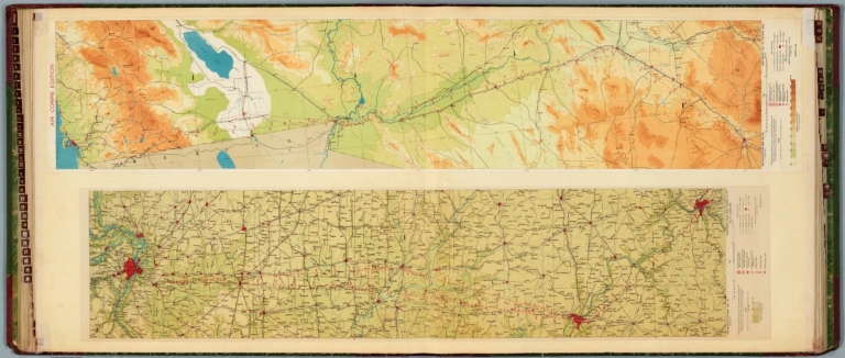
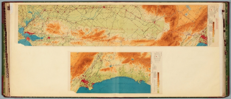
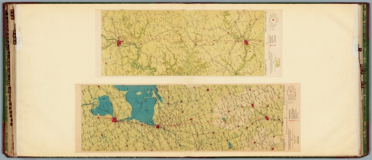
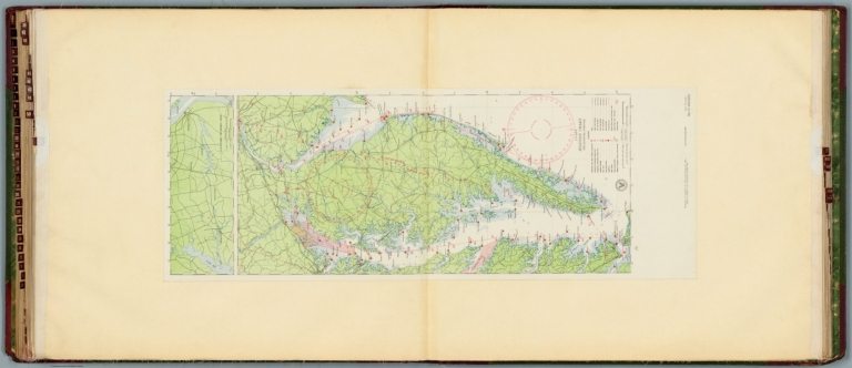
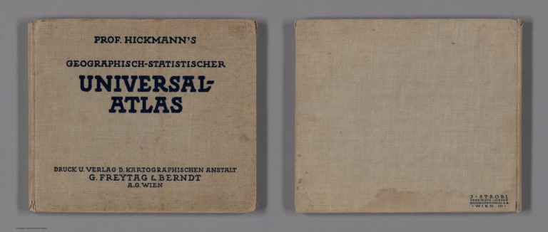


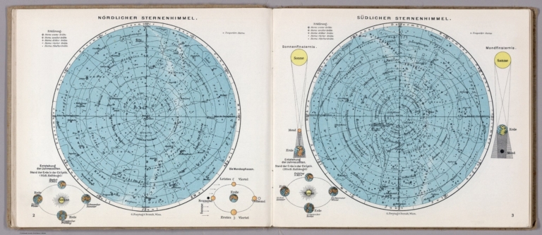
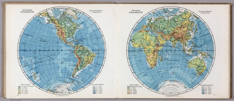


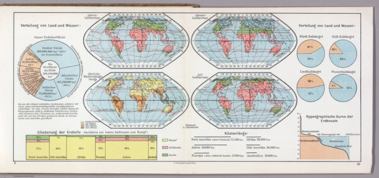
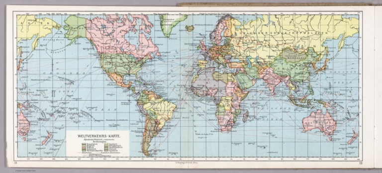


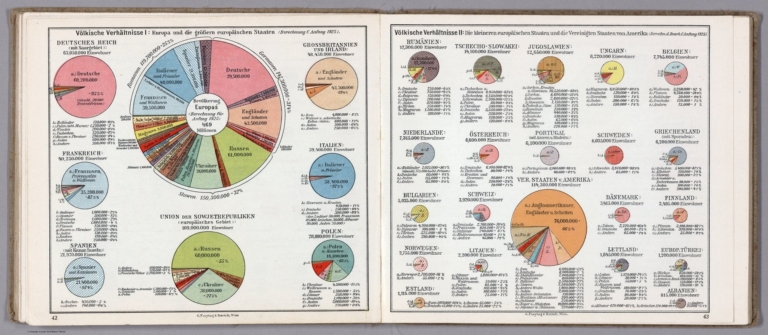


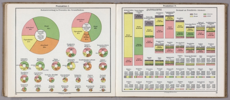
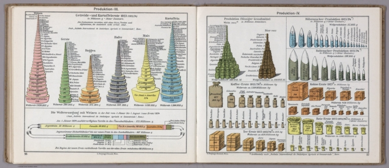
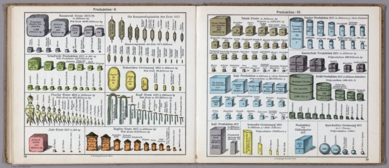
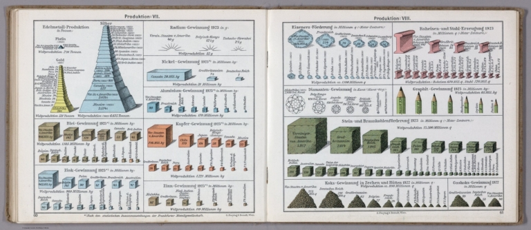


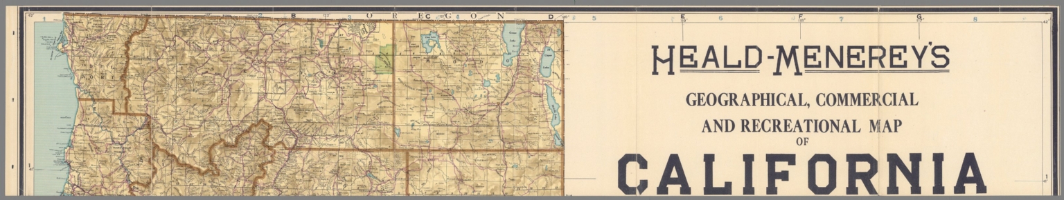
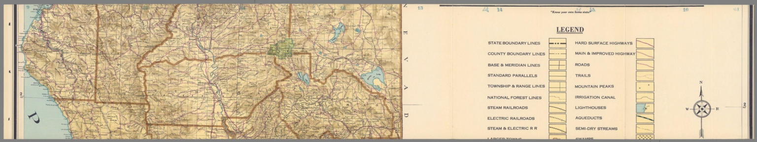
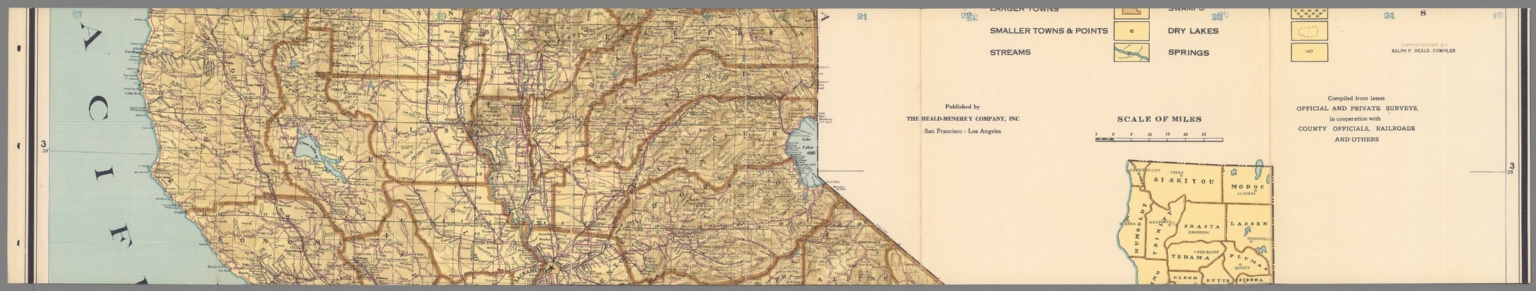
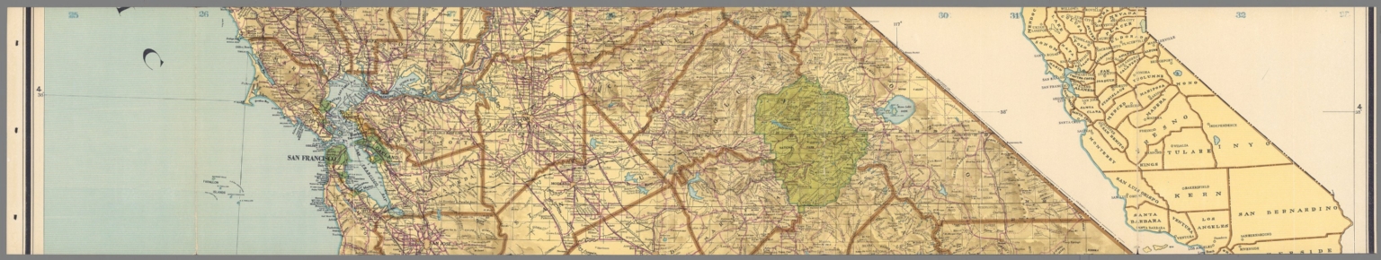
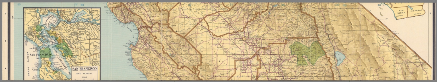
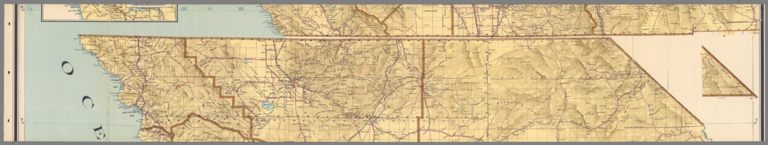
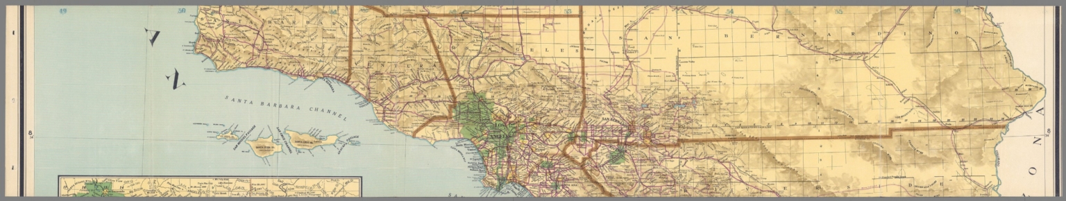
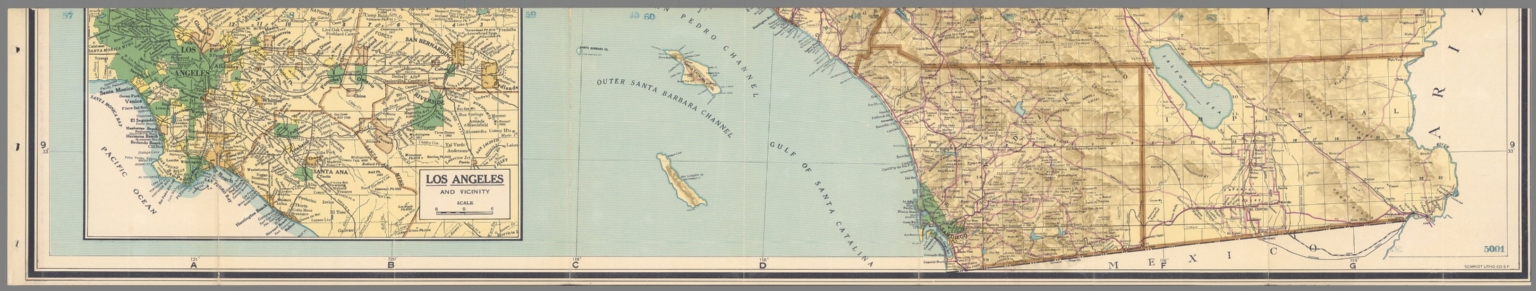

![انا وطن [Ana Vatan / Homeland].](https://www.davidrumsey.com/rumsey/Size2/RUMSEY~8~1/195/10876000.jpg)