|
Author
[Ford Motor Company, United States. Department of Commerce. Aeronautics Branch]
Full Title
Commerce and Army Air Corps airway maps : Department of Commerce maps -- Air Corps maps -- Hydrographic Office. Airway bulletin. No. 11a, August 26, 1927. Published in Information Division, Aeronautics Branch, Department of Commerce, Washington, D.C. U.S. Government Printing Office : 1927.
List No
14501.002
Note
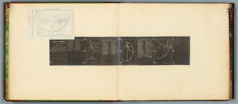
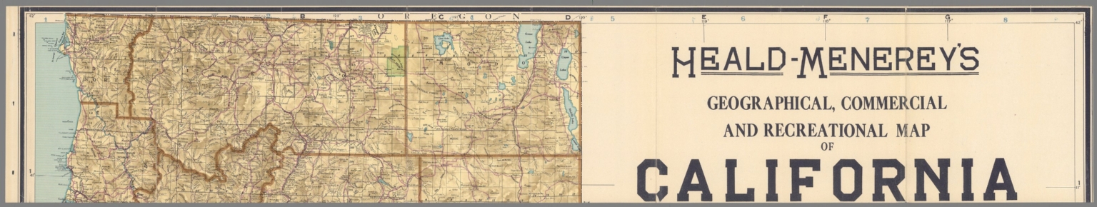
Four aeronautical charts of the United States. Charts feature airway strips. Charts also show political boundaries, cities with airports, bodies of water and coastlines. The first chart (printed on a white plate) is an index to the following three charts (printed in white on a black plate). The index chart includes a legend and bar scale given in miles. The following three charts each pertain to different departments - the Department of Commerce, Air Corps and Hydrographic Office - and each chart has a list of available maps, which are identifiable through the index map. Both plates are pasted to a double sheet. Together, maps are 37 x 99 cm, on double sheet, 60 x 136 cm.
Author
[Ford Motor Company, United States. Army. Air Corps, Geological Survey (U.S.). Topographic Branch]
Full Title
Air navigation map no. 1 (experimental) : Dayton, Ohio to Uniontown, Pa. Compiled and reproduced by the Engineer Reproduction Plant, Corps of Engineers. Under the direction of the Airways Section, Office Chief of Air Corps. 1926, Engineer Reproduction Plant, U.S. Army, Washington Barracks, D.C. 6833. R-1927. -- Air navigation map no. 2 : Washington D.C. to Uniontown, Pa. Prepared under the direction of the Airways Section, Office of the Chief of Air Corps by the Topographic Branch, U.S. Geological Survey, 1923. Revised by Engineer Reproduction Plant, U.S. Army, 1927. Engineer Reproduction Plant, U.S. Army, Washington, D.C. 6919. 1927.
List No
14501.003
Note
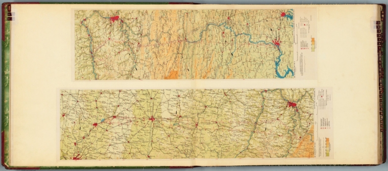
Two aeronautical charts representing the areas from Dayton, Ohio, to Uniontown, Pennsylvania, and from Washington D.C., to Uniontown, Pennsylvania and Wheeling, West Virginia. Features military, municipal, commercial, emergency, and seaplane landing fields. Also shows political boundaries, roads, railways, cities, towns, topography, bodies of water, and drainage. Relief shown with contour lines and color coding. Maps include latitudinal and longitudinal lines, legend, scale statements, and bar scales given in miles, as well as compass roses oriented toward top of sheet (with slight variation between the two maps). Color lithographs. Together, maps are 56 x 103 cm, on double sheet, 60 x 136 cm.
Author
[Ford Motor Company, Geological Survey (U.S.). Topographic Branch]
Full Title
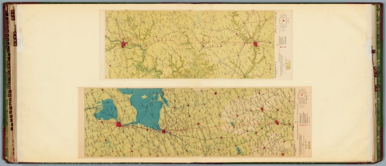
Air navigation map no. 3 (experimental) : Washington D.C. to New York, N.Y. Prepared under the direction of the Airways Section Office of the Chief of Air Service by the Topographic Branch, U.S. Geological Survey, 1923. Engineer Reproduction Plant, U.S. Army, Washington Barracks, D.C. 4915. 1923 - reprint 1926 - R-1927. -- Air navigation map [4] (experimental) : Washington D.C. to Hampton, Va. Prepared under the direction of the Airways Section, Office of the Chief of Air Corps by the Topographic Branch, U.S. Geological Survey, 1923. Engineer Reproduction Plant, U.S. Army, Washington Barracks, D.C. 6520. 1926.
List No
14501.004
Note
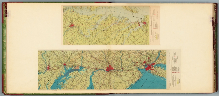
Two aeronautical charts representing the areas from Washington D.C., to New York, New York, and from Washington D.C. to Hampton, Virginia. Features military, municipal, commercial, emergency, and seaplane landing fields, as well as beacon lights. Also shows political boundaries, roads, railways, cities, towns, topography, bodies of water, and drainage. Relief shown with contour lines and color coding. Maps include latitudinal and longitudinal lines, legend, scale statements, and bar scales given in miles, as well as compass roses oriented toward top of sheet (with slight variation between the two maps). Color lithographs. Together, maps are 57 x 94 cm, on double sheet, 60 x 136 cm. Map number 4 provided with a handwritten annotation.
Author
[Ford Motor Company, Geological Survey (U.S.). Topographic Branch]
Full Title
Air navigation map [5] (experimental) : Dayton, Ohio to Rantoul, Ill. Prepared under the direction of the Airways Section Office of the Chief of Air Service by the Topographic Branch, U.S. Geological Survey, 1924. Engineer Reproduction Plant, U.S. Army, Washington Barracks, D.C. 1926, 4915-5. -- Air navigation map no. 6 (experimental) : New York, N.Y. to Boston, Mass. Prepared under the direction of the Airways Section Office of the Chief of Air Corps by the Topographic Branch, U.S. Geological Survey, 1924. Engineer Reproduction Plant, U.S. Army, Washington Barracks, D.C. 4915-6, 1924 - R-1927.
List No
14501.005
Note
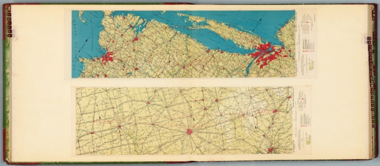
Two aeronautical charts representing the areas from Dayton, Ohio to Rantoul, Illinois, and from New York, New York, to Boston, Massachusetts. Features military, municipal, commercial, emergency, and seaplane landing fields, as well as beacon lights. Also shows political boundaries, roads, railways, cities, towns, topography, bodies of water, and drainage. Relief shown with contour lines and color coding. Maps include latitudinal and longitudinal lines, legend, scale statements, and bar scales given in miles, as well as compass roses oriented toward top of sheet (with slight variation between the two maps). Color lithographs. Together, maps are 56 x 92 cm, on double sheet, 60 x 136 cm. Map number 5 provided with a handwritten annotation.
Author
[Ford Motor Company, Geological Survey (U.S.). Topographic Branch]
Full Title
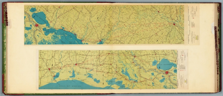
Air navigation map no. 7 (experimental) : New Orleans, La. to Beaumont, Texas. Prepared under the direction of the Airways Section Office of the Chief of Air Corps. By the Topographic Branch, U.S. Geological Survey, revised to July 15, 1927. Engineer Reproduction Plant, U.S. Army, Washington Barracks, D.C. 4915. 1924 - R1927. -- Air navigation map no. 8 (experimental) : New Orleans, La. to Montgomery, Ala. Prepared under the direction of the Airways Section Office of the Chief of Air Corps by the Topographic Branch, U.S. Geological Survey, 1924. Engineer Reproduction Plant, U.S. Army, Washington Barracks, D.C. 4915-8, 1924 - R1927.
List No
14501.006
Note
Two aeronautical charts representing the areas from New Orleans, Louisiana, to Beaumont, Texas, and from New Orleans to Montgomery, Alabama. Features military, municipal, commercial, emergency, and seaplane landing fields. Also shows political boundaries, roads, railways, cities, towns, topography, bodies of water, and drainage. Relief shown with contour lines and color coding. Maps include latitudinal and longitudinal lines, legend, scale statements, and bar scales given in miles, as well as compass roses oriented toward top of sheet (with slight variation between the two maps). Color lithographs. Together, maps are 57 x 114 cm, on double sheet, 60 x 136 cm.
Author
[Ford Motor Company, Geological Survey (U.S.). Topographic Branch, United States. Army. Air Corps]
Full Title
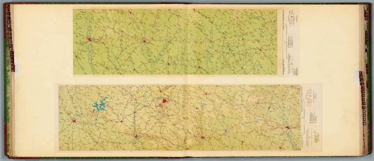
Air navigation map no. 15 (experimental) : Montgomery, Alabama to Augusta, Georgia. Prepared under the direction of the Airways Section Office of the Chief of Air Corps by the Topographic Branch, U.S. Geological Survey. 1926. Engineer Reproduction Plant, U.S. Army, Washington Barracks, D.C. 6572-15. 1926. -- Air navigation map no. 16 (experimental) : Augusta, GA. to Fayetteville, N.C. Compiled and reproduced by the Engineer Reproduction Plant, Corps of Engineers. Under the direction of the Airways Section, Office Chief of Air Corps. 1926. Engineer Reproduction Plant, U.S. Army, Washington Barracks, D.C. 4915. R-1927.
List No
14501.010
Note
Two aeronautical charts representing the areas from Montgomery, Alabama, to Augusta, Georgia, and from Augusta, Georgia, to Fayetteville, North Carolina. Features military, municipal, commercial, emergency, and seaplane landing fields. Also shows political boundaries, roads, railways, cities, towns, topography, bodies of water, shorelines, and drainage. Relief shown with contour lines and color coding. Maps include latitudinal and longitudinal lines, legend, scale statements, and bar scales given in miles, as well as compass roses oriented toward top of sheet (with slight variation between the two maps). Color lithographs. Together, maps are 57 x 102 cm, on double sheet, 60 x 136 cm.
Author
[Ford Motor Company, United States. Army. Air Corps, United States. War Department. Office of the Chief of Air Service]
Full Title
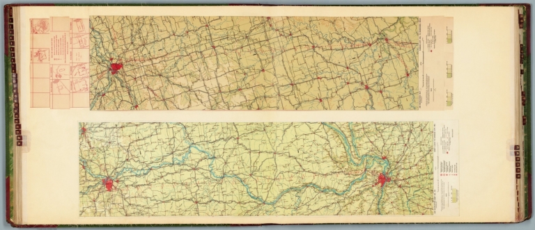
Air navigation map no. 23 (experimental) : Saint Louis to Kansas City, Mo. Compiled and reproduced by the Engineer Reproduction Plant, Corps of Engineers. Under the direction of the Airways Section, Office Chief of Air Corps. 1923. Engineer Reproduction Plant, U.S. Army, Washington Barracks, D.C. 4915. 1926. R1927. -- Air navigation map [24] (experimental) : Kansas City, Mo. to Muskogee, Okla. Compiled and reproduced by the Engineer Reproduction Plant, Corps of Engineers. Under the direction of the Airways Section, Office Chief of Air Service. 1923. Engineer Reproduction Plant, U.S. Army, Washington Barracks, D.C. 1924. 4915-24.
List No
14501.015
Note
Two aeronautical charts representing the areas from Saint Louis to Kansas City, Missouri, and from Kansas City, Missouri, to Muskogee, Oklahoma. Features military, municipal, commercial, emergency, and seaplane landing fields, as well as beacon lights. Also shows political boundaries, roads, railways, cities, towns, topography, bodies of water, shorelines, and drainage. Relief shown with contour lines and color coding. Maps include latitudinal and longitudinal lines, legend, scale statements, and bar scales given in miles, as well as compass roses oriented toward top of sheet (with slight variation between the two maps). aeronautical chart 24 includes eight inset maps showing route and landing facilities. Color lithographs. Together, maps are 56 x 120 cm, on double sheet, 60 x 136 cm. Map number 24 provided with a handwritten annotation.
Author
[Ford Motor Company, United States. Army. Air Corps, United States. War Department. Office of the Chief of Air Service]
Full Title
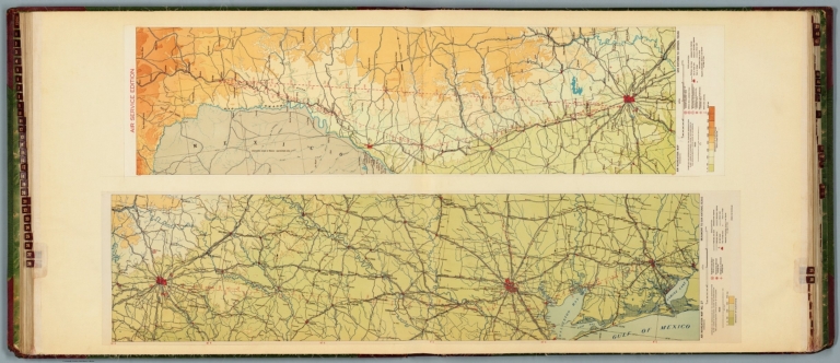
Air navigation map no. 27 (experimental) : Beaumont to San Antonio, Texas. Compiled and reproduced by the Engineer Reproduction Plant, Corps of Engineers. Under the direction of the Airways Section, Office Chief of Air Corps. 1923. Engineer Reproduction Plant, U.S. Army, Washington Barracks, D.C. 4915. 1923 - R1927. -- Air navigation map [28] (experimental) : San Antonio to Dryden, Texas. Compiled and reproduced by the Engineer Reproduction Plant, Corps of Engineers. Under the direction of the Airways Section, Office Chief of Air Service. 1924. Engineer Reproduction Plant, U.S. Army, Washington Barracks, D.C. 1924. 4915.
List No
14501.017
Note
Two aeronautical charts representing the areas from Beaumont to San Antonio, Texas, and from San Antonio to Dryden, Texas. Features military, municipal, commercial, emergency, and seaplane landing fields. Also shows political boundaries, roads, railways, cities, towns, topography, bodies of water, drainage, and coastlines. Relief shown with contour lines and color coding. Maps include latitudinal and longitudinal lines, legend, scale statements, and bar scales given in miles, as well as compass roses oriented toward top of sheet (with slight variation between the two maps). Color lithographs. Together, maps are 56 x 110 cm, on double sheet, 60 x 136 cm. Map number 28 provided with a handwritten annotation.
Author
[Ford Motor Company, United States. Army. Air Corps]
Full Title
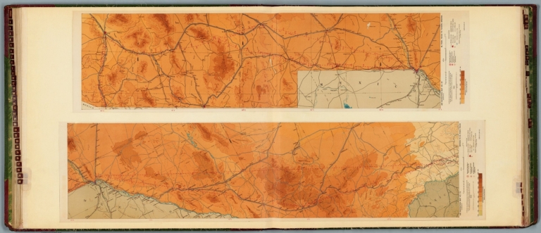
Air navigation map no. 29 (experimental) : Dryden to El Paso, Texas. Compiled and reproduced by the Engineer Reproduction Plant, Corps of Engineers. Under the direction of the Airways Section, Office Chief of Air Corps. 1924. Engineer Reproduction Plant, U.S. Army, Washington Barracks, D.C. 4915. 1924 -- Air navigation map no. 30 (experimental) : El Paso, Texas to Tucson, Arizona. Compiled and reproduced by the Engineer Reproduction Plant, Corps of Engineers. Under the direction of the Airways Section, Office Chief of Air Corps. 1924. Engineer Reproduction Plant, U.S. Army, Washington Barracks, D.C. 4915-30. 1924 R1927.
List No
14501.018
Note
Two aeronautical charts representing the areas from Dryden to El Paso, Texas, and from El Paso, Texas, to Tucson, Arizona. Features military, municipal, commercial, emergency, and seaplane landing fields. Also shows political boundaries, roads, railways, cities, towns, topography, bodies of water, and drainage. Relief shown with contour lines and color coding. Maps include latitudinal and longitudinal lines, legend, scale statements, and bar scales given in miles, as well as compass roses oriented toward top of sheet (with slight variation between the two maps). Color lithographs. Together, maps are 57 x 113 cm, on double sheet, 60 x 136 cm.
Author
[Ford Motor Company, United States. War Department. Office of the Chief of Air Service, United States. Army. Air Corps]
Full Title
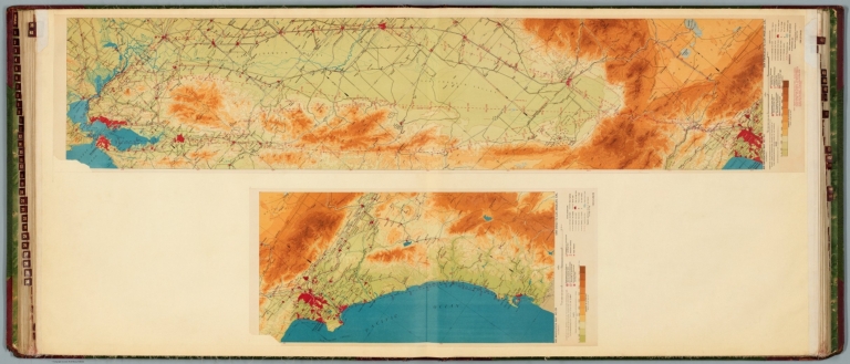
Air navigation map [31] (experimental) : Nogales and Tucson to Phoenix, Arizona. Compiled and reproduced by the Engineer Reproduction Plant, Corps of Engineers. Under the direction of the Airways Section, Office Chief of Air Service. 1924. -- Air navigation map no. 32 (experimental) : Phoenix, Arizona to San Diego, Calif.. Compiled and reproduced by the Engineer Reproduction Plant, Corps of Engineers. Under the direction of the Airways Section, Office Chief of Air Corps. 1924. Engineer Reproduction Plant, U.S. Army, Washington Barracks, D.C. 4915-30. 1924 - R1927.
List No
14501.019
Note
Two aeronautical charts representing the areas from Nogales and Tucson to Phoenix, Arizona, and from Phoenix, Arizona, to San Diego, California. Features military, municipal, commercial, emergency, and seaplane landing fields. Also shows political boundaries, roads, railways, cities, towns, topography, bodies of water, drainage, and coastlines. Relief shown with contour lines and color coding. Maps include latitudinal and longitudinal lines, legend, scale statements, and bar scales given in miles, as well as compass roses oriented toward top of sheet (with slight variation between the two maps). aeronautical chart 31 includes four inset maps showing route and landing facilities. Color lithographs. Together, maps are 56 x 115 cm, on double sheet, 60 x 135 cm. Map number 31 provided with a handwritten annotation.
Author
[Ford Motor Company, United States. Army. Air Corps]
Full Title
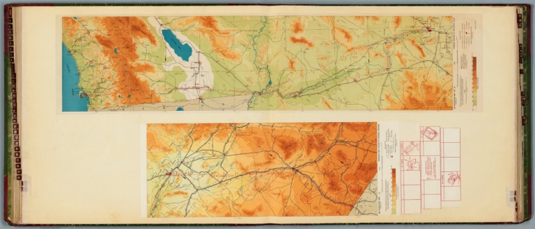
Air navigation map no. 37 (experimental) : Cincinatti, Ohio and Louisville, Ky. to St. Louis, Mo. Compiled and reproduced by the Engineer Reproduction Plant, Corps of Engineers. Under the direction of the Airways Section, Office Chief of Air Corps. 1925. Engineer Reproduction Plant, U.S. Army, Washington Barracks, D.C. 4915. 1926 - R1927. -- Air Corps Edition : Air navigation map no. 38 (experimental) : San Diego, Cal. to Tucson, Ariz. Compiled and reproduced by the Engineer Reproduction Plant, Corps of Engineers. Under the direction of the Airways Section, Office Chief of Air Corps. 1926. Engineer Reproduction Plant, U.S. Army, Washington Barracks, D.C. 6695.
List No
14501.022
Note
Two aeronautical charts representing the areas from Cincinnati, Ohio, and Louisville, Kentucky. to Saint Louis, Missouri, and from San Diego, California, to Tucson, Arizona. Features military, municipal, commercial, emergency, and seaplane landing fields, as well as beacon lights. Also shows political boundaries, roads, railways, cities, towns, topography, bodies of water, drainage, and coastlines. Relief shown with contour lines and color coding. Maps include latitudinal and longitudinal lines, legend, scale statements, and bar scales given in miles, as well as compass roses oriented toward top of sheet (with slight variation between the two maps). Color lithographs. Together, maps are 56 x 130 cm, on double sheet, 60 x 135 cm.
Author
[Ford Motor Company, United States. Army. Air Corps]
Full Title
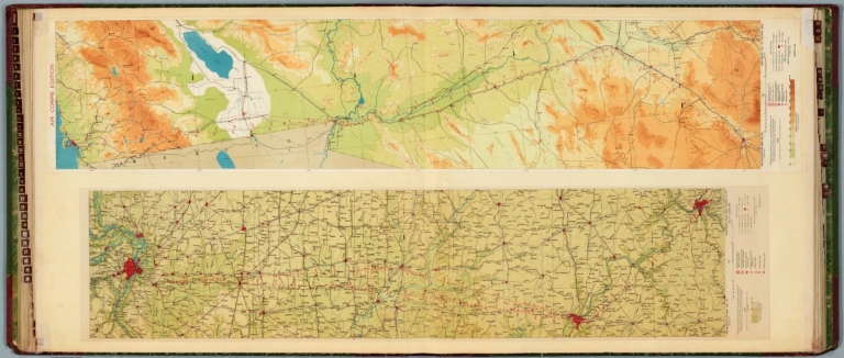
Air navigation map no. 39 (experimental) : San Diego to Los Angeles, Cal. Compiled and reproduced by the Engineer Reproduction Plant, Corps of Engineers. Under the direction of the Airways Section, Office Chief of Air Corps. 1925. Engineer Reproduction Plant, U.S. Army, Washington Barracks, D.C. 6762-39. R1927. -- Air navigation map no. 40 (experimental) : San Francisco to Los Angeles, Cal. Compiled and reproduced by the Engineer Reproduction Plant, Corps of Engineers. Under the direction of the Airways Section, Office Chief of Air Corps. 1926. Engineer Reproduction Plant, U.S. Army, Washington Barracks.
List No
14501.023
Note
Two aeronautical charts representing the areas from San Diego to Los Angeles, California, and from San Francisco to Los Angeles, California. Features military, municipal, commercial, emergency, and seaplane landing fields, as well as beacon lights. Also shows political boundaries, roads, railways, cities, towns, topography, bodies of water, drainage, and coastlines. Relief shown with contour lines and color coding. Maps include latitudinal and longitudinal lines, legend, scale statements, and bar scales given in miles, as well as compass roses oriented toward top of sheet (with slight variation between the two maps). Color lithographs. Together, maps are 56 x 127 cm, on double sheet, 60 x 135 cm.
Author
[Ford Motor Company, United States. War Department. Office of the Chief of Air Service, United States. Army. Air Corps]
Full Title
Air navigation map [47] (experimental) : Dayton, Ohio to Mt. Clemens, Mich. Compiled and reproduced by the Engineer Reproduction Plant, Corps of Engineers. Under the direction of the Airways Section, Office Chief of Air Service. 1925. Engineer Reproduction Plant, U.S. Army, Washington Barracks, D.C. 4915-47. 1926. -- Air navigation map 48 (experimental) : Louisville, Ky. to Nashville, Tenn. Compiled and reproduced by the Engineer Reproduction Plant, Corps of Engineers. Under the direction of the Airways Section, Office Chief of Air Corps. 1927. Engineer Reproduction Plant, U.S. Army, Washington Barracks, D.C. 6275-48.
List No
14501.027
Note
Two aeronautical charts representing the areas from Dayton, Ohio, to Mount Clemens, Michigan, and from Louisville, Kentucky, to Nashville, Tennessee. Features military, municipal, commercial, emergency, and seaplane landing fields. Also shows political boundaries, roads, railways, cities, towns, topography, bodies of water, drainage, and coastlines. Relief shown with contour lines and color coding. Maps include latitudinal and longitudinal lines, legend, scale statements, and bar scales given in miles, as well as compass roses oriented toward left of sheet (with slight variation between the two maps). Color lithographs. Together, maps are 56 x 86 cm, on double sheet, 60 x 135 cm. Map number 47 provided with a handwritten annotation.
Author
[Ford Motor Company, United States. Hydrographic Office]
Full Title
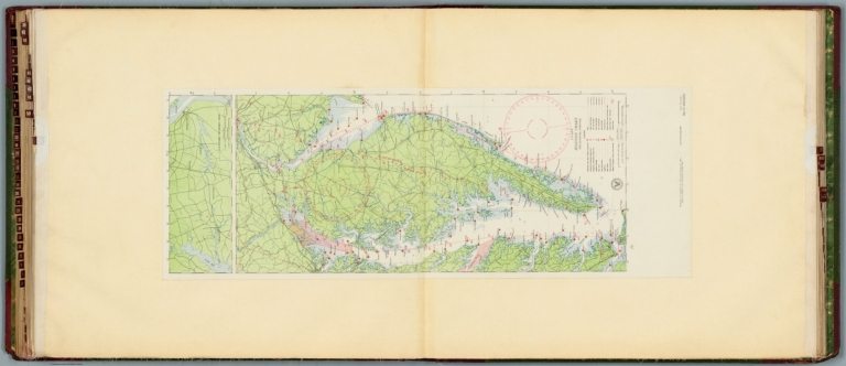
U.S. Navy aviation chart : Philadelphia - Norfolk. Washington, D.C. Published Feb. 1927, at the Hydrographic Office, under the authority of the Secretary of the Navy. 1st edition, Feb. 1927.
List No
14501.030
Note
Aeronautical chart representing the areas from Philadelphia, Pennsylvania, to Norfolk, Virginia. Features military, municipal, commercial, emergency, and seaplane landing fields, as well as racetracks, coast guard stations, lighthouses, and radio stations. Also shows roads, railways, cities, towns, bodies of water, drainage, and coastlines. Map includes latitudinal and longitudinal lines, a legend, scale statement, and bar scales given in nautical miles and statute miles, as well as a compass rose oriented toward top of sheet. Includes the seal of the Hydrographic Office, U.S. Navy. With one inset map: Chesapeake - Delaware Canal. Color lithograph. Map is 90 x 32 cm, on double sheet, 136 x 60 cm.
Author
[Hickmann, Anton Leo, 1834-1906, Fischer, Alois, b. 1894]
Full Title
(Covers to) Prof. Hickmann's Geographisch-statistischer universal-atlas. Druck u. verlag der kartographischen anstalt G. Freytag & Berndt A.G., Wien.
List No
13687.001
Author
[Hickmann, Anton Leo, 1834-1906, Fischer, Alois, b. 1894]
Full Title
(Title Page to) Prof. Hickmann's Geographisch-statistischer universal-atlas, 1927. Vollständig neubearbeitet von Alois Fischer. Druck u. verlag der kartographischen anstalt G. Freytag & Berndt A.G., Wien.
List No
13687.002
Author
[Hickmann, Anton Leo, 1834-1906, Fischer, Alois, b. 1894]
Full Title
Grossenverhaltnisse der planeten im vergleiche zur Sunne. G. Freytag & Berndt A.G., Wien. (to accompany) Prof. Hickmann's Geographisch-statistischer universal-atlas, 1927.
List No
13687.005
Note
Diagram of the Sun and planetary orbits. Showing comparison of sizes of the Sun and Planets.
Author
[Hickmann, Anton Leo, 1834-1906, Fischer, Alois, b. 1894]
Full Title
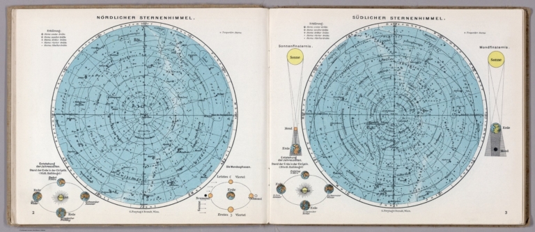
Nordlicher Sternenhimmel. Sudlicher Sternenhimmel. G. Freytag & Berndt A.G., Wien. (to accompany) Prof. Hickmann's Geographisch-statistischer universal-atlas, 1927.
List No
13687.006
Note
2 color circular maps of Northern and Southern Hemispheres on 2 pages. Shows comparison of sizes of the Sun and Planets.
Author
[Hickmann, Anton Leo, 1834-1906, Fischer, Alois, b. 1894]
Full Title
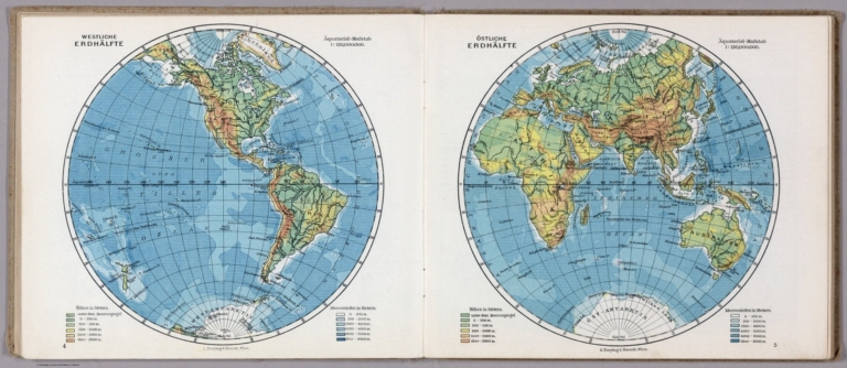
Westlche Erdhalfte. Ostlicher Erdhalfte. G. Freytag & Berndt A.G., Wien. (to accompany) Prof. Hickmann's Geographisch-statistischer universal-atlas, 1927.
List No
13687.007
Note
Color circular maps of the world, presenting Western and Eastern Hemispheres on 2 pages. Shows continental boundaries, countries, major cities, topography, deserts, bodies of water, drainage, coastlines and islands. Relief shown with hachures. Depth shown by gradient tints and soundings in Meter.
Author
[Hickmann, Anton Leo, 1834-1906, Fischer, Alois, b. 1894]
Full Title
Ideale ansichtder bedeutendsten hohen und Tiefen und Tiefen der erde. G. Freytag & Berndt A.G., Wien. (to accompany) Prof. Hickmann's Geographisch-statistischer universal-atlas, 1927.
List No
13687.008
Note
4 views on 1 sheet. Including comparative view of the Heights of the Principal Mountains and depths of seas in the world. With comparative view of the elevations of the Alps and the depth of the Mediterranean Sea. Relief shown by spot heights. Depth shown by soundings.
Author
[Hickmann, Anton Leo, 1834-1906, Fischer, Alois, b. 1894]
Full Title
Stromlangen und stromgebiete der bedeutendsten flüsse der erde. G. Freytag & Berndt A.G., Wien. (to accompany) Prof. Hickmann's Geographisch-statistischer universal-atlas, 1927.
List No
13687.009
Note
Color diagrams and charts, showing lengths of the principal rivers and river basins in the world.
Author
[Hickmann, Anton Leo, 1834-1906, Fischer, Alois, b. 1894]
Full Title
Pflanzen Regionen (Vegetationsformen) der Erde. G. Freytag & Berndt A.G., Wien. (to accompany) Prof. Hickmann's Geographisch-statistischer universal-atlas, 1927.
List No
13687.010
Note
Color map of the world, showing the vegetation regions and distribution areas of the principal plants. With chart of the percentage of soil utilization in the continents. Includes legend.
Author
[Hickmann, Anton Leo, 1834-1906, Fischer, Alois, b. 1894]
Full Title
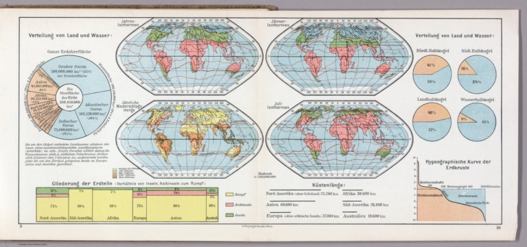
Verteilung von land und wasser. G. Freytag & Berndt A.G., Wien. (to accompany) Prof. Hickmann's Geographisch-statistischer universal-atlas, 1927.
List No
13687.011
Note
Folded maps, charts and diagrams on 2 sheets, showing distribution of land and water. Including 4 maps, show isothermal lines for January and July and for the entire year and annual precipitation. Diagrams and charts showing percentage of the whole surface of the earth's distribution of land and water and outline of the continents' coastal lengths.
Author
[Hickmann, Anton Leo, 1834-1906, Fischer, Alois, b. 1894]
Full Title
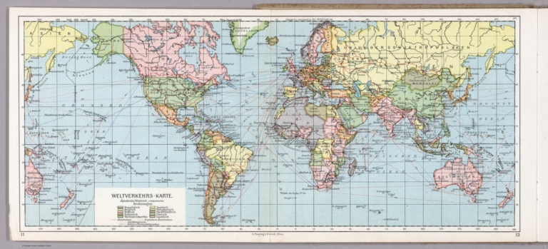
Weltverkehrs - Karte. G. Freytag & Berndt A.G., Wien. (to accompany) Prof. Hickmann's Geographisch-statistischer universal-atlas, 1927.
List No
13687.012
Note
Folded map of the world. Showing transportation routes including shipping lines, railways, overland telegraphs cables and projected railways. Color reference indicating European and United States possessions. Prime meridian: Greenwich.
Author
[Hickmann, Anton Leo, 1834-1906, Fischer, Alois, b. 1894]
Full Title
Asien. G. Freytag & Berndt A.G., Wien. (to accompany) Prof. Hickmann's Geographisch-statistischer universal-atlas, 1927.
List No
13687.032
Note
Political map of Asia. Showing political boundaries, cities, topography, bodies of water, drainage, coastlines, islands. railways, steamship routes and distances. Includes color reference to European and American possessions. Relief shown by hachures and spot heights. Prime meridian: Greenwich.
Author
[Hickmann, Anton Leo, 1834-1906, Fischer, Alois, b. 1894]
Full Title
Japan. G. Freytag & Berndt A.G., Wien. (to accompany) Prof. Hickmann's Geographisch-statistischer universal-atlas, 1927.
List No
13687.033
Note
Political map of Japan, with insets: Kwangtung Halbinsel (Guangdong province) and Formosa (Taiwan). Relief shown by hachures and spot heights. Prime meridian: Greenwich.
Author
[Hickmann, Anton Leo, 1834-1906, Fischer, Alois, b. 1894]
Full Title
Afrika. G. Freytag & Berndt A.G., Wien. (to accompany) Prof. Hickmann's Geographisch-statistischer universal-atlas, 1927.
List No
13687.034
Note
Political map of Africa. Showing political boundaries, cities, topography, bodies of water, drainage, coastlines, islands. railways, steamship routes and distances. Includes color reference to European possessions. Relief shown by hachures and spot heights. Prime meridian: Greenwich.
Author
[Hickmann, Anton Leo, 1834-1906, Fischer, Alois, b. 1894]
Full Title
Nord-Amerika. G. Freytag & Berndt A.G., Wien. (to accompany) Prof. Hickmann's Geographisch-statistischer universal-atlas, 1927.
List No
13687.035
Note
Political map of North America. Showing political boundaries, cities, topography, bodies of water, coastlines, islands. railways, steamship routes and distances. Includes color reference to European possessions. Relief shown by hachures and spot heights. Prime meridian: Greenwich.
Author
[Hickmann, Anton Leo, 1834-1906, Fischer, Alois, b. 1894]
Full Title
Vereinigte Staaten von. Amerika und Mexico. G. Freytag & Berndt A.G., Wien. (to accompany) Prof. Hickmann's Geographisch-statistischer universal-atlas, 1927.
List No
13687.036
Note
Map of the United states of. America and Mexico. Showing political and administrative divisions, cities, topography, bodies of water, coastlines, islands. railways, steamship routes and distances. Includes legend and list of States. Relief shown by hachures and spot heights. Prime meridian: Greenwich.
Author
[Hickmann, Anton Leo, 1834-1906, Fischer, Alois, b. 1894]
Full Title
Die Rassen der Erde die volker der Erde. G. Freytag & Berndt A.G., Wien. (to accompany) Prof. Hickmann's Geographisch-statistischer universal-atlas, 1927.
List No
13687.040
Note
Statistical diagrams, showing the races and population of the earth. Note: Population of the earth in (early 1925) 1.864 Million.
Author
[Hickmann, Anton Leo, 1834-1906, Fischer, Alois, b. 1894]
Full Title
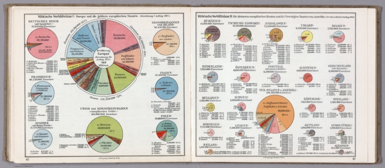
Volkische verhältnis I: Europa und die großen europäischen Staaten. Volkische verhältnis II: Die kleineren Europaischen Staaten die Vereinigten Staaten von Amerka (Berechnung f. ansfang 1925. G. Freytag & Berndt A.G., Wien. (to accompany) Prof. Hickmann's Geographisch-statistischer universal-atlas, 1927.
List No
13687.041
Note
Statistical diagrams on 2 pages. Showing the national relationship in early 1925: I: comparative size, nationalities and population of Europe and the major European states. II. Comparative size, nationalities and population of the smaller European states and the United States of America.
Author
[Hickmann, Anton Leo, 1834-1906, Fischer, Alois, b. 1894]
Full Title
Die Religionen der Erde. Die Religionen Europas. G. Freytag & Berndt A.G., Wien. (to accompany) Prof. Hickmann's Geographisch-statistischer universal-atlas, 1927.
List No
13687.042
Note
Statistical diagrams. Showing the religions of the world and the religions of Europe. Charts showing the spread Jewish people in and Mosaic people in Europe and in the world.
Author
[Hickmann, Anton Leo, 1834-1906, Fischer, Alois, b. 1894]
Full Title
Vergleichende grosse aller staaten der Erde nach ihrem flacheninhalt in quadratkilometern. G. Freytag & Berndt A.G., Wien. (to accompany) Prof. Hickmann's Geographisch-statistischer universal-atlas, 1927.
List No
13687.043
Note
Statistical graphs. Comparative sizes of all countries in the world bases on their area in square kilometers.
Author
[Hickmann, Anton Leo, 1834-1906, Fischer, Alois, b. 1894]
Full Title
Vergleichende grosse aller staaten der Erde nach ihrem Bevolkerungszah. G. Freytag & Berndt A.G., Wien. (to accompany) Prof. Hickmann's Geographisch-statistischer universal-atlas, 1927.
List No
13687.044
Note
Statistical graphs. Comparative sizes of all countries in the world based on their population.
Author
[Hickmann, Anton Leo, 1834-1906, Fischer, Alois, b. 1894]
Full Title
Die Aussenbesitzungen der kolonialmächte. G. Freytag & Berndt A.G., Wien. (to accompany) Prof. Hickmann's Geographisch-statistischer universal-atlas, 1927.
List No
13687.045
Note
Statistical diagrams and graphs. Showing the foreign possessions of the colonial powers based on the area and population.
Author
[Hickmann, Anton Leo, 1834-1906, Fischer, Alois, b. 1894]
Full Title
Die territorialen Veranderungen infolge des Weltkrieges. G. Freytag & Berndt A.G., Wien. (to accompany) Prof. Hickmann's Geographisch-statistischer universal-atlas, 1927.
List No
13687.046
Note
Statistical diagrams and graphs. Showing Territorial changes as a result of the World War. Note: Population figures are as of early 1925.
Author
[Hickmann, Anton Leo, 1834-1906, Fischer, Alois, b. 1894]
Full Title
Bevolkerungstatistik: I. G. Freytag & Berndt A.G., Wien. (to accompany) Prof. Hickmann's Geographisch-statistischer universal-atlas, 1927.
List No
13687.047
Note
Population Statistics part I. Showing population growth and sex ratio data.
Author
[Hickmann, Anton Leo, 1834-1906, Fischer, Alois, b. 1894]
Full Title
Bevolkerungstatistik: II. G. Freytag & Berndt A.G., Wien. (to accompany) Prof. Hickmann's Geographisch-statistischer universal-atlas, 1927.
List No
13687.048
Note
Population Statistics part II. Showing migration from Europe in 1923. Migrations to the main immigrant countries. Migrations to the United States 1820-1920.
Author
[Hickmann, Anton Leo, 1834-1906, Fischer, Alois, b. 1894]
Full Title
Vergleichende größe der bedeutendsten städte der Erde: I. G. Freytag & Berndt A.G., Wien. (to accompany) Prof. Hickmann's Geographisch-statistischer universal-atlas, 1927.
List No
13687.049
Note
4 maps and notes on 1 page. Part I: Showing comparative size of the most important cities in the world.
Author
[Hickmann, Anton Leo, 1834-1906, Fischer, Alois, b. 1894]
Full Title
Vergleichende größe der bedeutendsten städte der Erde: II. G. Freytag & Berndt A.G., Wien. (to accompany) Prof. Hickmann's Geographisch-statistischer universal-atlas, 1927.
List No
13687.050
Note
11 maps and notes on 1 page. Part II: Showing comparative size of the most important cities in the world.
Author
[Hickmann, Anton Leo, 1834-1906, Fischer, Alois, b. 1894]
Full Title
Vergleichende größe der bedeutendsten städte der Erde: III. G. Freytag & Berndt A.G., Wien. (to accompany) Prof. Hickmann's Geographisch-statistischer universal-atlas, 1927.
List No
13687.051
Note
11 maps and notes on 1 page. Part III: Comparative size of the most important cities in the world.
Author
[Hickmann, Anton Leo, 1834-1906, Fischer, Alois, b. 1894]
Full Title
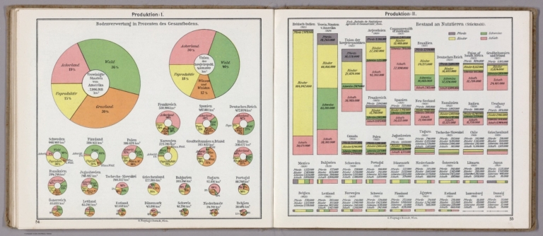
Produktion: I-II. G. Freytag & Berndt A.G., Wien. (to accompany) Prof. Hickmann's Geographisch-statistischer universal-atlas, 1927.
List No
13687.052
Note
Statistical analysis of agricultural products and livestock farming on 2 sheets. Part I: Showing Soil utilization as percentage of total soil. Part II: Stock of farm animals, including horses, cattle, pigs and sheep.
Author
[Hickmann, Anton Leo, 1834-1906, Fischer, Alois, b. 1894]
Full Title
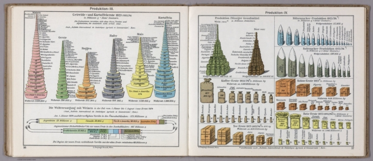
Produktion: III-IV. G. Freytag & Berndt A.G., Wien. (to accompany) Prof. Hickmann's Geographisch-statistischer universal-atlas, 1927.
List No
13687.053
Note
Statistical analysis of agricultural products on 2 sheet. Part III: Production of grain and potato 1923/24. Part IV: Production of wine, beet sugar, coffee, tea, cocoa, and rice 1923/24.
Author
[Hickmann, Anton Leo, 1834-1906, Fischer, Alois, b. 1894]
Full Title
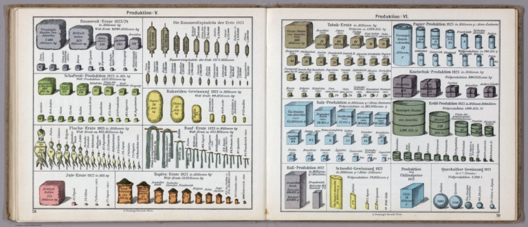
Produktion: V-VI. G. Freytag & Berndt A.G., Wien. (to accompany) Prof. Hickmann's Geographisch-statistischer universal-atlas, 1927.
List No
13687.054
Note
Statistical analysis of agricultural and industrial products on 2 sheet. Part V: Production of textile raw materials, and Jute, hemp and hops harvest 1923/24. Part VI: Production of Tobacco, paper products, rubber, salt, petroleum, mercury extraction, etc.,1923/24.
Author
[Hickmann, Anton Leo, 1834-1906, Fischer, Alois, b. 1894]
Full Title
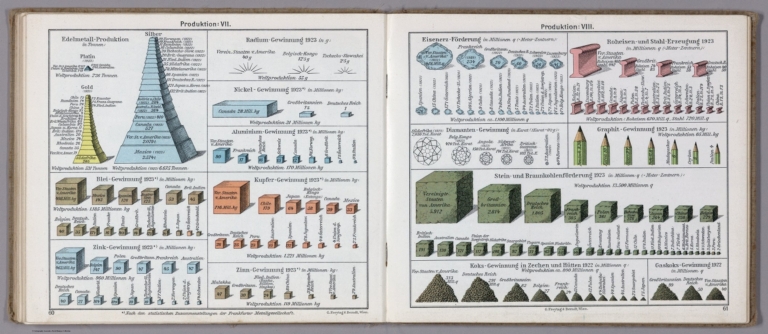
Produktion: VII-VIII. G. Freytag & Berndt A.G., Wien. (to accompany) Prof. Hickmann's Geographisch-statistischer universal-atlas, 1927.
List No
13687.055
Note
Statistical analysis of industrial products on 2 sheet. Part VII: Production of precious metals, and extraction of radium,copper, nickels, zinc and Tin. Part VIII: Mining and extraction of Iron ore coal, graphite coke extraction and steel production.
Author
[Hickmann, Anton Leo, 1834-1906, Fischer, Alois, b. 1894]
Full Title
Die Wasserkräfte der Erde und ihre Ausnutzung. (1924). G. Freytag & Berndt A.G., Wien. (to accompany) Prof. Hickmann's Geographisch-statistischer universal-atlas, 1927.
List No
13687.056
Note
Statistical diagrams. Showing water resources and exploitation of the world.
Author
[Hickmann, Anton Leo, 1834-1906, Fischer, Alois, b. 1894]
Full Title
Vergleichende länge der Telegraphenlinien. G. Freytag & Berndt A.G., Wien. (to accompany) Prof. Hickmann's Geographisch-statistischer universal-atlas, 1927.
List No
13687.059
Note
Statistical diagrams. Showing comparative Length of telegraph lines. Number of telephone stations. Submarine cables in Kilometers in 1922.
Author
[Hickmann, Anton Leo, 1834-1906, Fischer, Alois, b. 1894]
Full Title
Kraftwagen Statistik 1925/26. G. Freytag & Berndt A.G., Wien. (to accompany) Prof. Hickmann's Geographisch-statistischer universal-atlas, 1927.
List No
13687.061
Note
Statistical diagrams. Comparing motor vehicle stock across the world, 1925/26.
Author
[Hickmann, Anton Leo, 1834-1906, Fischer, Alois, b. 1894]
Full Title
Welthandelsflotte Mitte 1925. Baubestand des weltschiffbaues Mitte 1924. G. Freytag & Berndt A.G., Wien. (to accompany) Prof. Hickmann's Geographisch-statistischer universal-atlas, 1927.
List No
13687.063
Note
Statistical diagrams. Showing World merchant fleet in mid. 1925. And comparative stock of world shipbuilding in the middle of 1924.
Author
[Hickmann, Anton Leo, 1834-1906, Fischer, Alois, b. 1894]
Full Title
Friedensstärke der landstreitkräfte der wichtigsten staaten 1924. G. Freytag & Berndt A.G., Wien. (to accompany) Prof. Hickmann's Geographisch-statistischer universal-atlas, 1927.
List No
13687.080
Note
Statistical diagrams: showing the strength of the Land forces, naval forces and air forces of the important countries in 1924.
Author
[Hickmann, Anton Leo, 1834-1906, Fischer, Alois, b. 1894]
Full Title
Handelsflaggen. G. Freytag & Berndt A.G., Wien. (to accompany) Prof. Hickmann's Geographisch-statistischer universal-atlas, 1927.
List No
13687.081
Note
Color display of the flags of various nations.
Author
[Bonner, Mary Graham, 1890-1974, Price, Luxor]
Full Title
(Book cover to) The Magic Map, by Mary Graham Bonner, Illustrated by Luxor Price. New York, the Macaulay Company. Copyright, 1927, by the Macaulay Company. Printed in the United States of America.
List No
11562.001
Note
Paper dust jacket with flap text on the inside. Covers the hard cover of the 1927 1st edition of "The Magic Map" written by Mary Graham Bonner. Depicting North and South America as people between oceans filled with peculiar fish.
Author
[Bonner, Mary Graham, 1890-1974, Price, Luxor]
Full Title
(Cover to) The Magic Map, by Mary Graham Bonner, Illustrated by Luxor Price. New York, the Macaulay Company. Copyright, 1927, by the Macaulay Company. Printed in the United States of America.
List No
11562.002
Note
First edition of "The Magic Map" 1927, written by Mary Graham Bonner, teaching concepts of geography as fascinating and as adventurous as travel and actual exploration. Illustrated by Luxor Price in his distinctive style of map making and yet are full of whimsical fun and fact. It introduced young people to the fun of learning geography by humanizing in his illustrations the Atlantic Ocean, Latitude & Longitude, Cape Horn, etc. Published by the Macaulay Company in New York. In 238 pages of descriptive text with imprint on verso of title page and 16 illustrations, printed in blue and black. Includes colorful frontispiece and dust jacket depicting North and South America as people between oceans filled with peculiar fish. Includes flap text on the inside front and back of the dust jacket. Bound in orange cloth hard cover boards with black lettering and illustrations on the front board and spine. Illustrated end paper in black, white, and aqua, signed by Luxor Price affixed to the front and back, with inscription dated Dec. 25, 1930 in the front.
Author
[Bonner, Mary Graham, 1890-1974, Price, Luxor]
Full Title
(Cover to) The Magic Map, by Mary Graham Bonner, Illustrated by Luxor Price. New York, the Macaulay Company. Copyright, 1927, by the Macaulay Company. Printed in the United States of America.
List No
11562.003
Note
Front endpaper on 2 pages, with humorous illustrations in black, white, and aqua, signed by Luxor Price affixed to the front and back, with inscription dated Dec. 25, 1930.
Author
[Bonner, Mary Graham, 1890-1974, Price, Luxor]
Full Title
(Half Title Page to) The Magic Map, by Mary Graham Bonner, Illustrated by Luxor Price. New York, the Macaulay Company. Copyright, 1927, by the Macaulay Company. Printed in the United States of America.
List No
11562.004
Note
First edition of "The Magic Map" 1927, written by Mary Graham Bonner, teaching concepts of geography as fascinating and as adventurous as travel and actual exploration. Illustrated by Luxor Price in his distinctive style of map making and yet are full of whimsical fun and fact. It introduced young people to the fun of learning geography by humanizing in his illustrations the Atlantic Ocean, Latitude & Longitude, Cape Horn, etc. Published by the Macaulay Company in New York. In 238 pages of descriptive text with imprint on verso of title page and 16 illustrations, printed in blue and black. Includes colorful frontispiece and dust jacket depicting North and South America as people between oceans filled with peculiar fish. Includes flap text on the inside front and back of the dust jacket. Bound in orange cloth hard cover boards with black lettering and illustrations on the front board and spine. Illustrated end paper in black, white, and aqua, signed by Luxor Price affixed to the front and back, with inscription dated Dec. 25, 1930 in the front.
Author
[Bonner, Mary Graham, 1890-1974, Price, Luxor]
Full Title
(Frontispiece) The Magic Map, by Mary Graham Bonner, Illustrated by Luxor Price. New York, the Macaulay Company. Copyright, 1927, by the Macaulay Company. Printed in the United States of America.
List No
11562.005
Note
First edition of "The Magic Map" 1927, written by Mary Graham Bonner, teaching concepts of geography as fascinating and as adventurous as travel and actual exploration. Illustrated by Luxor Price in his distinctive style of map making and yet are full of whimsical fun and fact. It introduced young people to the fun of learning geography by humanizing in his illustrations the Atlantic Ocean, Latitude & Longitude, Cape Horn, etc. Published by the Macaulay Company in New York. In 238 pages of descriptive text with imprint on verso of title page and 16 illustrations, printed in blue and black. Includes colorful frontispiece and dust jacket depicting North and South America as people between oceans filled with peculiar fish. Includes flap text on the inside front and back of the dust jacket. Bound in orange cloth hard cover boards with black lettering and illustrations on the front board and spine. Illustrated end paper in black, white, and aqua, signed by Luxor Price affixed to the front and back, with inscription dated Dec. 25, 1930 in the front.
Author
[Bonner, Mary Graham, 1890-1974, Price, Luxor]
Full Title
(Title Page to) The Magic Map, by Mary Graham Bonner, Illustrated by Luxor Price. New York, the Macaulay Company. Copyright, 1927, by the Macaulay Company. Printed in the United States of America.
List No
11562.006
Note
First edition of "The Magic Map" 1927, written by Mary Graham Bonner, teaching concepts of geography as fascinating and as adventurous as travel and actual exploration. Illustrated by Luxor Price in his distinctive style of map making and yet are full of whimsical fun and fact. It introduced young people to the fun of learning geography by humanizing in his illustrations the Atlantic Ocean, Latitude & Longitude, Cape Horn, etc. Published by the Macaulay Company in New York. In 238 pages of descriptive text with imprint on verso of title page and 16 illustrations, printed in blue and black. Includes colorful frontispiece and dust jacket depicting North and South America as people between oceans filled with peculiar fish. Includes flap text on the inside front and back of the dust jacket. Bound in orange cloth hard cover boards with black lettering and illustrations on the front board and spine. Illustrated end paper in black, white, and aqua, signed by Luxor Price affixed to the front and back, with inscription dated Dec. 25, 1930 in the front.
Author
[Bonner, Mary Graham, 1890-1974, Price, Luxor]
Full Title
(Index Page to) The Magic Map, by Mary Graham Bonner, Illustrated by Luxor Price. New York, the Macaulay Company. Copyright, 1927, by the Macaulay Company. Printed in the United States of America.
List No
11562.009
Note
First edition of "The Magic Map" 1927, written by Mary Graham Bonner, teaching concepts of geography as fascinating and as adventurous as travel and actual exploration. Illustrated by Luxor Price in his distinctive style of map making and yet are full of whimsical fun and fact. It introduced young people to the fun of learning geography by humanizing in his illustrations the Atlantic Ocean, Latitude & Longitude, Cape Horn, etc. Published by the Macaulay Company in New York. In 238 pages of descriptive text with imprint on verso of title page and 16 illustrations, printed in blue and black. Includes colorful frontispiece and dust jacket depicting North and South America as people between oceans filled with peculiar fish. Includes flap text on the inside front and back of the dust jacket. Bound in orange cloth hard cover boards with black lettering and illustrations on the front board and spine. Illustrated end paper in black, white, and aqua, signed by Luxor Price affixed to the front and back, with inscription dated Dec. 25, 1930 in the front.
Author
[Bonner, Mary Graham, 1890-1974, Price, Luxor]
Full Title
"It's truly a magic map." Luxor Price. (to accompany) The Magic Map, by Mary Graham Bonner, Illustrated by Luxor Price. New York, the Macaulay Company. Copyright, 1927.
List No
11562.010
Note
Color pictorial map. "A living Map" and when you are adventuring you will only meet Map people ..." Showing buildings, forest, mountains and clouds. Relief shown by hachures and pictorially. Includes a compass rose oriented with the north to the upper right margin.
Author
[Bonner, Mary Graham, 1890-1974, Price, Luxor]
Full Title
"I'm Western Hemisphere." (to accompany) The Magic Map, by Mary Graham Bonner, Illustrated by Luxor Price. New York, the Macaulay Company. Copyright, 1927.
List No
11562.011
Note
Color pictorial map of Western Hemisphere as "a creature who was dressed in a suit of many colors with strange, untidy fringes and ragged places here and there." Showing countries, regions, forest, mountains, oceans, ships and bridges "Golden Gate as the entrance to the harbor of San Francisco". Relief shown pictorially. Includes a compass rose oriented with the north to the upper left margin.
Author
[Bonner, Mary Graham, 1890-1974, Price, Luxor]
Full Title
"We are the Earth's Policemen." (to accompany) The Magic Map, by Mary Graham Bonner, Illustrated by Luxor Price. New York, the Macaulay Company. Copyright, 1927.
List No
11562.012
Note
Color pictorial map of the United States. "We are patrolmen you may never see ... We are boundary men ..." Showing political and states boundaries, forest, mountains, and rivers. Relief shown pictorially.
Author
[Bonner, Mary Graham, 1890-1974, Price, Luxor]
Full Title
"I'm Father Atlas." Luxor Price. (to accompany) The Magic Map, by Mary Graham Bonner, Illustrated by Luxor Price. New York, the Macaulay Company. Copyright, 1927.
List No
11562.013
Note
Color pictorial map. Showing mountains, oceans, lands, volcanoes and forests. Relief shown pictorially. "I'm Father Atlas, In my portfolio are maps and maps-all the maps."
Author
[Bonner, Mary Graham, 1890-1974, Price, Luxor]
Full Title
"I'v called it my magic map!" Luxor Price. (to accompany) The Magic Map, by Mary Graham Bonner, Illustrated by Luxor Price. New York, the Macaulay Company. Copyright, 1927.
List No
11562.014
Note
Color pictorial map of the world. Showing mountains, oceans, lands, volcanoes and forests. Relief shown pictorially. "The Book of geography" in the top center beneath North Pole. North America in the lower right and Australia, Africa, South America and India in lower panel. Includes compass rose oriented with the north to upper left.
Author
[Bonner, Mary Graham, 1890-1974, Price, Luxor]
Full Title
"We're the world's most considerate twins." Luxor Price. (to accompany) The Magic Map, by Mary Graham Bonner, Illustrated by Luxor Price. New York, the Macaulay Company. Copyright, 1927.
List No
11562.015
Note
Color pictorial map of Great Britain and part of France. Showing latitude and longitude, buildings, ships, landmarks, light houses, etc. Relief shown pictorially. Prime meridian is Greenwich.
Author
[Bonner, Mary Graham, 1890-1974, Price, Luxor]
Full Title
Then the bread basket stood up! Luxor Price. (to accompany) The Magic Map, by Mary Graham Bonner, Illustrated by Luxor Price. New York, the Macaulay Company. Copyright, 1927.
List No
11562.016
Note
Color pictorial map of the Mississippi Valley. Showing farms, road, and railroaed. Relief shown pictorially.
Author
[Bonner, Mary Graham, 1890-1974, Price, Luxor]
Full Title
"We're Oceans," Atlantic Said. Luxor Price. (to accompany) The Magic Map, by Mary Graham Bonner, Illustrated by Luxor Price. New York, the Macaulay Company. Copyright, 1927.
List No
11562.017
Note
Color pictorial map of the Oceans. "The Ocean," Said Atlantic ... "is just one great huge body of water lying in great hollows of land."
Author
[Bonner, Mary Graham, 1890-1974, Price, Luxor]
Full Title
"My World Parents call me North Temperature." Luxor Price. (to accompany) The Magic Map, by Mary Graham Bonner, Illustrated by Luxor Price. New York, the Macaulay Company. Copyright, 1927.
List No
11562.018
Note
Color pictorial map, showing climatic conditions in different parts of the world. Regions have been classified according to their main climate.
Author
[Bonner, Mary Graham, 1890-1974, Price, Luxor]
Full Title
"I'm the Guld Stream. Have you ever heard of me?" Luxor Price. (to accompany) The Magic Map, by Mary Graham Bonner, Illustrated by Luxor Price. New York, the Macaulay Company. Copyright, 1927.
List No
11562.019
Note
Color pictorial map, showing the North Atlantic currents with its northern extension towards Europe.
Author
[Bonner, Mary Graham, 1890-1974, Price, Luxor]
Full Title
"My name is Isthmus means Neck." Luxor Price. (to accompany) The Magic Map, by Mary Graham Bonner, Illustrated by Luxor Price. New York, the Macaulay Company. Copyright, 1927.
List No
11562.020
Note
Color pictorial map, extending from North America to the northern part of South America. Relief shown pictorially.
Author
[Bonner, Mary Graham, 1890-1974, Price, Luxor]
Full Title
"I suppose you must be Cape Horn." Luxor Price. (to accompany) The Magic Map, by Mary Graham Bonner, Illustrated by Luxor Price. New York, the Macaulay Company. Copyright, 1927.
List No
11562.021
Note
Color pictorial map of the southern part of South America. Relief shown pictorially.
Author
[Bonner, Mary Graham, 1890-1974, Price, Luxor]
Full Title
"The Great Lakes, My friend." Luxor Price. (to accompany) The Magic Map, by Mary Graham Bonner, Illustrated by Luxor Price. New York, the Macaulay Company. Copyright, 1927.
List No
11562.022
Note
Color pictorial map of the Great Lakes. Showing major cities, landmarks, and coastal towns.
Author
[Bonner, Mary Graham, 1890-1974, Price, Luxor]
Full Title
"I'm entirely surrounded by admiring water." Newfoundland. Luxor Price. (to accompany) The Magic Map, by Mary Graham Bonner, Illustrated by Luxor Price. New York, the Macaulay Company. Copyright, 1927.
List No
11562.023
Note
Color pictorial map of Newfoundland. Showing Coast of Labrador, coastal towns, lighthouses and landmarks.
Author
[Bonner, Mary Graham, 1890-1974, Price, Luxor]
Full Title
"I always thought it a Great joke the way Greenland was named." Greenland. Luxor Price. (to accompany) The Magic Map, by Mary Graham Bonner, Illustrated by Luxor Price. New York, the Macaulay Company. Copyright, 1927.
List No
11562.024
Note
Color pictorial map of Greenland.
Author
[Bonner, Mary Graham, 1890-1974, Price, Luxor]
Full Title
"I divided them - North and South.". Luxor Price. (to accompany) The Magic Map, by Mary Graham Bonner, Illustrated by Luxor Price. New York, the Macaulay Company. Copyright, 1927.
List No
11562.025
Note
Color pictorial map, showing continents and regions.
Author
[Bonner, Mary Graham, 1890-1974, Price, Luxor]
Full Title
(Cover to) The Magic Map, by Mary Graham Bonner, Illustrated by Luxor Price. New York, the Macaulay Company. Copyright, 1927, by the Macaulay Company. Printed in the United States of America.
List No
11562.026
Note
Back endpaper on 2 pages, with humorous illustrations in black, white, and aqua, signed by Luxor Price affixed to the front and back,
Author
Bartholomew, John
Full Title
(Covers to) Bartholomew's Railway Map Of The British Isles. 1927 ... The Edinburgh Geographical Institute. Copyright - John Bartholomew & Son, Ltd. (inset) London And Suburbs. (inset) Channel Islands.
List No
1543.001
Author
Bartholomew, John
Full Title
Bartholomew's Railway Map Of The British Isles. 1927 ... The Edinburgh Geographical Institute. Copyright - John Bartholomew & Son, Ltd. (inset) London And Suburbs. (inset) Channel Islands.
List No
1543.002
Author
Canadian National Railways
Full Title
(Covers to) Map of the Canadian Rockies : Triangle Tour of British Columbia, Alaska and the Yukon. Canadian National.
List No
14461.001
Note
Covers to Map of the Canadian Rockies, folded. Front cover includes a slogan from the mapmaker. Printed in red on orange-colored paper.
Author
Canadian National Railways
Full Title
The Triangle Tour of British Columbia : Jasper National Park, Mount Robson Park, Canadian Rockies and the Scenic Seas of the North Pacific Cost. Canadian National Railways. Lithographed in Canada.
List No
14461.002
Note
Map of the Triangle Tour of British Columbia. Shows political boundaries, cities, railways, steamship lines, trails, parks, topography, bodies of water, drainage, coastlines and islands. Relief shown with shading. Includes a legend and descriptive text. With photographic views: Totem Poles, Kitwanga -- Scenic Seas, Pacific Coast -- The Fraser Canyon -- Mount Robson -- Jasper Park Lodge, Jasper National Park -- Roof of the World. Colored lithograph. Map is 43 x 76 cm, on sheet 44 x 77 cm.
Author
Canadian National Railways
Full Title
Alaska and the Yukon -- Routes of Canadian National Pacific Coast Services, Canadian National Steamship Company Ltd.
List No
14461.003
Note
Two maps of the Alaska and the Yukon, as well as the railway lines of the Canadian National Pacific Coast Services and the steamship lines of the Canadian National Steamship Company Ltd. Maps also show political boundaries, cities, parks, topography, bodies of water, drainage, coastlines and islands. Relief shown with shading. Includes descriptive text. Colored lithograph. Together, maps are 75 x 42 cm, on sheet 77 x 44 cm.
Author
[Confederazione generale dell'industria italiana, Associzaione fra le società italiane per azioni]
Full Title
Industria mineraria : Valore della produzione (lire attvali).
List No
14403.021
Note
Chart showing the production value within the mining industry in Italy, from 1876 to 1927. Includes descriptive text. Colored lithograph, on sheet 21 x 29 cm.
Author
[Heald-Menerey Company, Inc., Heald, Ralph P.]
Full Title
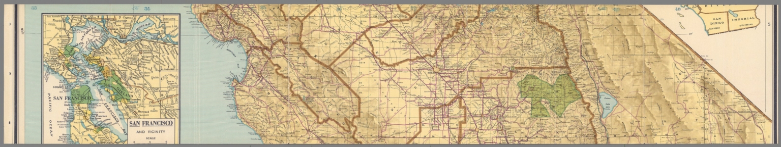
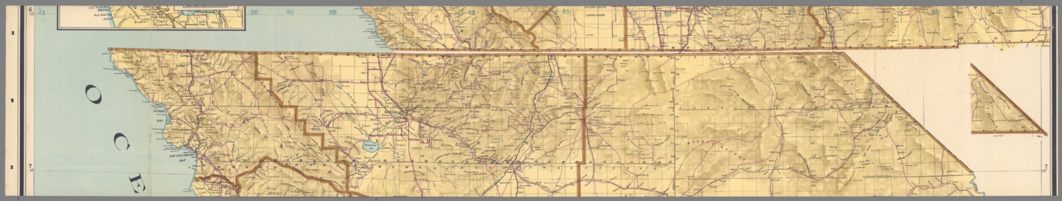
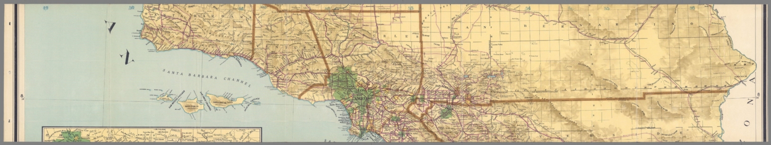
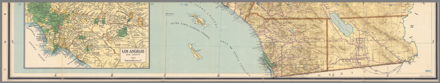
(Covers to) Heald-Menerey's Geographical, Commercial and Recreational Map of California
List No
15251.001
Author
[Heald-Menerey Company, Inc., Heald, Ralph P.]
Full Title
(Text page to) Heald-Menerey's Geographical, Commercial and Recreational Map of California
List No
15251.003
Author
[Heald-Menerey Company, Inc., Heald, Ralph P.]
Full Title
(Contents to) Heald-Menerey's Geographical, Commercial and Recreational Map of California
List No
15251.004
Author
[Heald-Menerey Company, Inc., Heald, Ralph P.]
Full Title
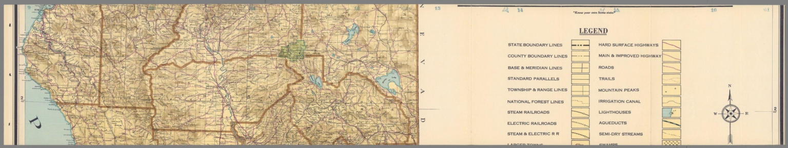
(Sheet 1) Heald-Menerey's Geographical, Commercial and Recreational Map of California
List No
15251.005
Author
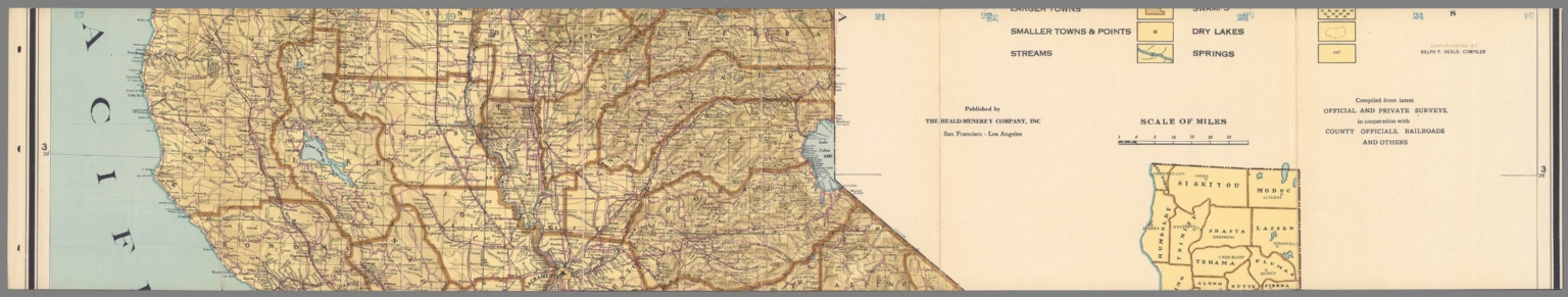
[Heald-Menerey Company, Inc., Heald, Ralph P.]
Full Title
(Sheet 2) Heald-Menerey's Geographical, Commercial and Recreational Map of California
List No
15251.006
Author
[Heald-Menerey Company, Inc., Heald, Ralph P.]
Full Title
(Sheet 3) Heald-Menerey's Geographical, Commercial and Recreational Map of California
List No
15251.007
Author
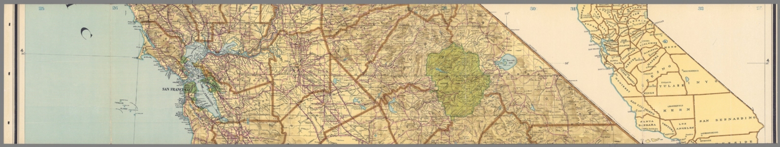
[Heald-Menerey Company, Inc., Heald, Ralph P.]
Full Title
(Sheet 4) Heald-Menerey's Geographical, Commercial and Recreational Map of California
List No
15251.008
Author
[Heald-Menerey Company, Inc., Heald, Ralph P.]
Full Title
(Sheet 5) Heald-Menerey's Geographical, Commercial and Recreational Map of California
List No
15251.009
Author
[Heald-Menerey Company, Inc., Heald, Ralph P.]
Full Title
(Sheet 6) Heald-Menerey's Geographical, Commercial and Recreational Map of California
List No
15251.010
Author
[Heald-Menerey Company, Inc., Heald, Ralph P.]
Full Title
(Sheet 7) Heald-Menerey's Geographical, Commercial and Recreational Map of California
List No
15251.011
Author
[Heald-Menerey Company, Inc., Heald, Ralph P.]
Full Title
(Sheet 8) Heald-Menerey's Geographical, Commercial and Recreational Map of California
List No
15251.012
Author
[Heald-Menerey Company, Inc., Heald, Ralph P.]
Full Title
(Composite map of) Heald-Menerey's Geographical, Commercial and Recreational Map of CaliforniaHeald-Menerey's Geographical, Commercial and Recreational Map of California
List No
15251.013
Author
(سودى)نك يكى خريطه كلياتندن [SÛDÎ’NIN YENI HARITA KÜLLIYATINDAN / SUDI’S NEW CARTOGRAPHIC ESTABLISHMENT].
Full Title
انا وطن [Ana Vatan / Homeland].
List No
10876.000
Author
Kneese, George A.
Full Title
Official Map of San Mateo County California 1927. Compiled from Official Records and Surveys by Geo. A. Kneese, County Surveyor.
List No
10687.000
Author
Ikbal Kutuphanesi Sahibi Huseyin
Full Title
(Covers; Title Page to) Tajadud maktab atlasi = New school atlas. Ikbal Kutuphanesi Sahibi Huseyin. Istanbul. 1927-1345. .
List No
13435.001
Note
Title page and covers, with lettering in black and red, table of contents on the front cover, with old annotation, text and advertisement on back cover.
Author
Ikbal Kutuphanesi Sahibi Huseyin
Full Title
Sharghi nesfe Koreh= Western half of the wolrd. Gharbi nesfe koreh = Eastern half of the world. (to accompany) Tajadud maktab atlasi = New school atlas. 1927-1345.
List No
13435.002
Note
Double hemisphere map of the world, with insets and comparative colored view of volcanoes and comparative mountain heights in different regions.
Author
Ikbal Kutuphanesi Sahibi Huseyin
Full Title
(Solar system, Sun, Moon) . (to accompany) Tajadud maktab atlasi = New school atlas. 1927-1345.
List No
13435.003
Note
Chart of the solar system, planetary orbits, lunar orbits and lunar eclipse.
Author
Ikbal Kutuphanesi Sahibi Huseyin
Full Title
(Map of the world) . (to accompany) Tajadud maktab atlasi = New school atlas. 1927-1345.
List No
13435.004
Note
Political map of the world, with time zones.
Author
Ikbal Kutuphanesi Sahibi Huseyin
Full Title
Turkiye = Turkey. Katabikhanih Ikbal. (to accompany) Tajadud maktab atlasi = New school atlas. 1927-1345.
List No
13435.011
Note
Political map of Turkey . Shows capitals and major cities.
|


![انا وطن [Ana Vatan / Homeland].](https://www.davidrumsey.com/rumsey/Size2/RUMSEY~8~1/195/10876000.jpg)


