|
Author
[Ford Motor Company, United States. Army. Air Corps, Geological Survey (U.S.). Topographic Branch]
Full Title
Air navigation map no. 9 (experimental) : Chicago, Ill. to Iowa City, Iowa. Compiled and reproduced by the Engineer Reproduction Plant, Corps of Engineers. Under the direction of the Airways Section, Office Chief of Air Corps. 1924. Engineer Reproduction Plant, U.S. Army, Washington Barracks, D.C. 4915. 1924. -- Air navigation map [10] (experimental) : Iowa City, Iowa to Omaha, Nebr. Prepared under the direction of the Airways Section Office of the Chief of Air Service by the Topographic Branch, U.S. Geological Survey, 1924. Engineer Reproduction Plant, U.S. Army, Washington Barracks, D.C. 4915-10. 1924.
List No
14501.007
Note
Two aeronautical charts representing the areas from Chicago, Illinois, to Iowa City, Iowa, and from Iowa City, Iowa, to Omaha, Nebraska. Features military, municipal, commercial, emergency, and seaplane landing fields. Also shows political boundaries, roads, railways, cities, towns, topography, bodies of water, and drainage. Relief shown with contour lines and color coding. Maps include latitudinal and longitudinal lines, legend, scale statements, and bar scales given in miles, as well as compass roses oriented toward top of sheet (with slight variation between the two maps). Color lithographs. Together, maps are 57 x 96 cm on double sheet, 60 x 136 cm. Map number 10 provided with a handwritten annotation.
Author
Ministry of Justice Turkey
Full Title
جريدهء عدليه [Cerîde-i Adliye also Cerîde-i Adliyye]
List No
15819.001
Note
Dated on cover: November 1340 (1924)
Author
Ministry of Justice Turkey
Full Title
جريدهء عدليه [Cerîde-i Adliye also Cerîde-i Adliyye]
List No
15819.002
Note
September 1340 (1924)
Author
Engineer Office 9th Corps
Full Title
Map of The Presidio of San Francisco California. Traced in the Engineer Office Headquarters 9th Corps Area. March 1924.
List No
15815.000
Author
Gutierrez, Pedro (fl. 1900 - 1957)
Full Title
Plano de Subdivision Country Club Park. Propiedad Del County Club Park Investment Company. Habana Cuba 1924
List No
15581.000
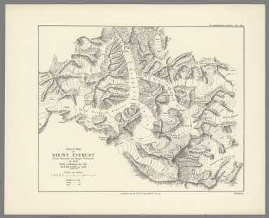
Author
[Royal Geographical Society, Wheeler, Major]
Full Title
Sketch Map of Mount Everest from Surveys by Major Wheeler in 1921 With additions by the Expedition of 1924.
List No
15025.000
Note
Date estimated
Author
Magyar Folyam – és Tengerhajózási Részvénytársaság (M.F.T.R.)
Full Title
M.F.T.R. Hajóállomány 1894 - 1924
List No
15003.000
Author
[Birdseye, C.H., Burchard, R.W., U.S. Geological Survey]
Full Title
(Composite map of) Sheets A - N. Plan and Profile of Colorado River From Lees Ferry, Ariz., To Black Canyon, Ariz.-Nev., and Virgin River, Nev. 21 Sheets (14 plans, 7 profiles).
List No
10974.001
Author
[Birdseye, C.H., Burchard, R.W., U.S. Geological Survey]
Full Title
Sheet A. Plan and Profile of Colorado River From Lees Ferry, Ariz., To Black Canyon, Ariz.-Nev., and Virgin River, Nev. 21 Sheets (14 plans, 7 profiles).
List No
10974.002
Author
[Birdseye, C.H., Burchard, R.W., U.S. Geological Survey]
Full Title
Sheet B. Plan and Profile of Colorado River From Lees Ferry, Ariz., To Black Canyon, Ariz.-Nev., and Virgin River, Nev. 21 Sheets (14 plans, 7 profiles).
List No
10974.003
Author
[Birdseye, C.H., Burchard, R.W., U.S. Geological Survey]
Full Title
Sheet C. Plan and Profile of Colorado River From Lees Ferry, Ariz., To Black Canyon, Ariz.-Nev., and Virgin River, Nev. 21 Sheets (14 plans, 7 profiles).
List No
10974.004
Author
[Birdseye, C.H., Burchard, R.W., U.S. Geological Survey]
Full Title
Sheet D. Plan and Profile of Colorado River From Lees Ferry, Ariz., To Black Canyon, Ariz.-Nev., and Virgin River, Nev. 21 Sheets (14 plans, 7 profiles).
List No
10974.005
Author
[Birdseye, C.H., Burchard, R.W., U.S. Geological Survey]
Full Title
Sheet E. Plan and Profile of Colorado River From Lees Ferry, Ariz., To Black Canyon, Ariz.-Nev., and Virgin River, Nev. 21 Sheets (14 plans, 7 profiles).
List No
10974.006
Author
[Birdseye, C.H., Burchard, R.W., U.S. Geological Survey]
Full Title
Sheet F. Plan and Profile of Colorado River From Lees Ferry, Ariz., To Black Canyon, Ariz.-Nev., and Virgin River, Nev. 21 Sheets (14 plans, 7 profiles).
List No
10974.007
Author
[Birdseye, C.H., Burchard, R.W., U.S. Geological Survey]
Full Title
Sheet G. Plan and Profile of Colorado River From Lees Ferry, Ariz., To Black Canyon, Ariz.-Nev., and Virgin River, Nev. 21 Sheets (14 plans, 7 profiles).
List No
10974.008
Author
[Birdseye, C.H., Burchard, R.W., U.S. Geological Survey]
Full Title
Sheet H. Plan and Profile of Colorado River From Lees Ferry, Ariz., To Black Canyon, Ariz.-Nev., and Virgin River, Nev. 21 Sheets (14 plans, 7 profiles).
List No
10974.009
Author
[Birdseye, C.H., Burchard, R.W., U.S. Geological Survey]
Full Title
Sheet I. Plan and Profile of Colorado River From Lees Ferry, Ariz., To Black Canyon, Ariz.-Nev., and Virgin River, Nev. 21 Sheets (14 plans, 7 profiles).
List No
10974.010
Author
[Birdseye, C.H., Burchard, R.W., U.S. Geological Survey]
Full Title
Sheet J. Plan and Profile of Colorado River From Lees Ferry, Ariz., To Black Canyon, Ariz.-Nev., and Virgin River, Nev. 21 Sheets (14 plans, 7 profiles).
List No
10974.011
Author
[Birdseye, C.H., Burchard, R.W., U.S. Geological Survey]
Full Title
Sheet K. Plan and Profile of Colorado River From Lees Ferry, Ariz., To Black Canyon, Ariz.-Nev., and Virgin River, Nev. 21 Sheets (14 plans, 7 profiles).
List No
10974.012
Author
[Birdseye, C.H., Burchard, R.W., U.S. Geological Survey]
Full Title
Sheet L Plan and Profile of Colorado River From Lees Ferry, Ariz., To Black Canyon, Ariz.-Nev., and Virgin River, Nev. 21 Sheets (14 plans, 7 profiles).
List No
10974.013
Author
[Birdseye, C.H., Burchard, R.W., U.S. Geological Survey]
Full Title
Sheet M. Plan and Profile of Colorado River From Lees Ferry, Ariz., To Black Canyon, Ariz.-Nev., and Virgin River, Nev. 21 Sheets (14 plans, 7 profiles).
List No
10974.014
Author
[Birdseye, C.H., Burchard, R.W., U.S. Geological Survey]
Full Title
Sheet N. Plan and Profile of Colorado River From Lees Ferry, Ariz., To Black Canyon, Ariz.-Nev., and Virgin River, Nev. 21 Sheets (14 plans, 7 profiles).
List No
10974.015
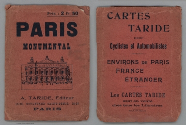
Author
[Borremans, F., Taride, A.]
Full Title
(Covers to) Paris Ses Monuments. Guide Pratique Du Visiteur.
List No
10886.001
Note
Date estimated, with help from James Strudwick who pointed out "directly above the tip of the Eiffel Tower on the Rumsey map you'll find the avenues Wilson, George V, and Tokio, all named in 1918-19 for France's allies in the Great War."
Author
[Borremans, F., Taride, A.]
Full Title
Paris Ses Monuments. Guide Pratique Du Visiteur.
List No
10886.002
Note
Date estimated, with help from James Strudwick who pointed out "directly above the tip of the Eiffel Tower on the Rumsey map you'll find the avenues Wilson, George V, and Tokio, all named in 1918-19 for France's allies in the Great War."
Author
Windes & Marsh
Full Title
Map of the Village of Glencoe Cook County, Ill.
List No
10650.005
Note
"Real estate map of the Village of Glencoe in Cook County, Illinois drawn to the scale of 200 feet to the inch. Glencoe was the first town in Illinois to use zoning codes, enacted in 1921. Shows individually numbered plots within labeled subdivisions and additions. Includes the location of the Skokie Country Club, which hosted the 1922 U.S. Open. Dated 1924 and published by the civil engineering/surveying firm of Windes & Marsh in Winnetka." (Curtis Wright, 2020)
Author
Harumoto, Ogawa
Full Title
World New Cartoon Bird View Map. (inset) (Small world political map with names in Japanese and English).
List No
12233.000
Author
Egypt. Maṣlaḥat al-Misāḥah.
Full Title
Map of Cairo showing Mohammedan Monuments.
List No
10482.000
Note
"This exceedingly high-quality map depicts ‘Old Cairo’, the parts of the city that were founded during medieval times, located on the highlands above the ‘newer’ neighbourhoods along the Nile. It was created by the Survey of Egypt, then one of the most professional mapping agencies in the World, predicated upon the synergy of the most authoritative topographical and urban mapping combined with the latest archaeological surveys. Cairo was the greatest centre of culture, learning and commerce during the ‘Islamic Golden age’. Commencing in the early 20th Century professional archaeologists as well as art and architectural historians became interested in scientifically recording Cairo’s sensational Islamic buildings and monuments. The map employs colours to denote sites built across the city during the eras of the three great Islamic empires that controlled Cairo prior to the arrival of the Ottomans in 1517: the ‘Fatimid and Pre-Fatimid Monuments’ (909 - 1171), shaded in Red; the ‘Aiyubid [Ayyubid] Monuments’ (1171 - 1260), shaded in Green; and the ‘Mameluke Monuments’ (1260 - 1517), shaded in Blue. These mosques, palaces, madrassas, and fortifications appear amidst the otherwise buff-coloured city which generally consisted of buildings built during the subsequent Ottoman and British Protectorate periods. The map shows that many of the greatest edifices from the periods of the three great Islamic empires have survived, although only traces of the vast Fatimid Place can be found amongst the foundations of newer buildings. Each of the historical sites is named in Gothic script and features a corresponding numeral which refers to that which appears upon the plaques affixed to each building by the civic authorities. The two insets on the left-hand side showcase sites in areas outside of the city proper. We understand that the first edition the map was issued in 1924, while an Arabic language version was published in 1948. The present revised, official edition was issued in 1950-1 (correction, this copy is the first edition, issued in 1924), while several facsimile (unofficial) versions have been issued since then. The Survey of Egypt followed the initial production of the present issue of the map with a small booklet, Index to Mohammedan monuments appearing on the special 1:5000 scale maps of Cairo (Cairo, 1951), that is not present here, but seems to have been issued with the latter-releases of the map. Cairo during the ‘Islamic Golden Age’ Cairo was traditionally the largest and most culturally and economically important city in the Islamic world. The Muslim conquest of Byzantine Egypt occurred between 639 and 646 AD. While the Cairo area has been settled for thousands of years, with the key Ancient Egyptian cities of Giza and Memphis located nearby, the city proper was not founded until 969, when it became the principal city, and sometimes capital, of the Fatimid Caliphate, a Shia Muslim empire which controlled much of North Africa, the Levant and Hejaz between 909 and 1171. Cairo rapidly rose to become a centre of great wealth, at the nexus of global trade routes as well as home to some of the world’s foremost centres of education and the arts. Befitting tis importance, great monuments of Islamic architecture were built across the city. The Al-Azhar Madrassa (no. 97 on the map), which later grew into a university, was founded in 970-2 and today remains the world’s most prestigious institute of Islamic learning. The map notes some Islamic monuments made before 969, as the pre-Cairo rural landscape featured some small mosques, houses and fortifications. The Fatimids were replaced by the Ayyubid Dynasty (1171 - 1260), a regime of Kurdish origin, founded by the legendary conqueror Saladin, whereupon Cairo remained the prosperous centre of an empire spanning much of the Middle East. The Mamelukes were an elite class of soldier-bureaucrats descended from former Christian slaves. In 1250, they took over Egypt, the Levant and Hejaz, forming the Mameluke Sultanate, with its capital in Cairo. It was during the early part of their regime that Cairo reached its zenith as the principal centre of the Islamic Golden Age. The epicentre of a global trading network that spanned from India to Spain, Cairo far surpassed all European cities in wealth and cultural sophistication, and many exquisite works of architecture were built to reflect this glorious state. The Mameluke Sultanate was conquered by the Ottomans in 1517 and Cairo ceased to be an imperial capital. However, while technically subject to the Sublime Porte, Egypt maintained a high degree of autonomy and was the wealthiest and most prosperous part of the Ottoman Empire; Cairo remained a highly important centre. Fortunately, as the repent map reveals, the survival rate of Cairo’s great works of Islamic architecture from the Fatimid, Ayyubid and Mameluke periods is impressively high, and many sites can be visited today. References: OCLC: 17543226." (Alexander Johnson, 2020)
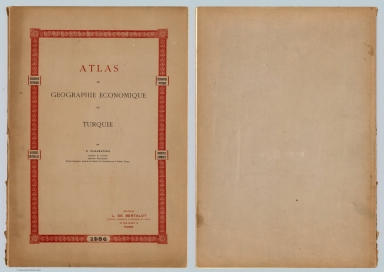
Author
Khanzadyan, Zadig
Full Title
(Title Page to) Atlas de geographie economique de Turquie : par Z. Khanzadian. Editeur L. de Bertalot. 1924.
List No
13321.002
Author
Khanzadyan, Zadig
Full Title
Cartes historiques des geographes musulmans. (to accompany) Atlas de geographie economique de Turquie : par Z. Khanzadian. Editeur L. de Bertalot. 1924.
List No
13321.020
Note
Six historical color maps by Muslim Geographers, on sheet 55x37. Including Carte No. 1: Carte generale d' Al-Istakhri et Ibn Ḥawqal. Xeme. Siecle. No.2: Carte generale de l' Idrisi l' an 1154. Cartes No.3-6 : Possessions tourques dans la mer Ionienne. Les provinces Tourques du Caucase. Arabie. Perse. 1640 par Kiatib-Tchekebi. Covering the world, Africa, Turkey, Saudi Arabi and Iran. In Franche and Ottoman Turkish languages. Relief shown by hachures and pictorially.
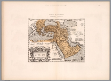
Author
Khanzadyan, Zadig
Full Title
Cartes historiques de la Turquie : Depuis la fondation de la dynastie Osman en 1300 : jusqua l' etablishment de la Republique Turque 1924. (to accompany) Atlas de geographie economique de Turquie : par Z. Khanzadian. Editeur L. de Bertalot. 1924.
List No
13321.023
Note
8 historical and chronological maps of Turkey on 1 sheet, on sheet 55x37. Show the founding of the Osman Dynasty in 1300 to the establishment of the Turkish Republic 1924. Maps dated 1285-1923.
Author
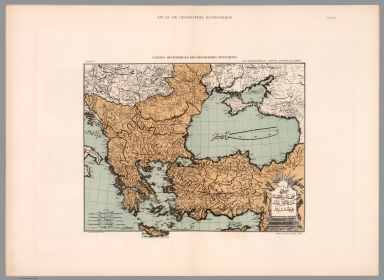
Khanzadyan, Zadig
Full Title
Turquie d'Asie et Caucase : Relief du sol. (to accompany) Atlas de geographie economique de Turquie : par Z. Khanzadian. Editeur L. de Bertalot. 1924.
List No
13321.026
Note
2 geological map of Asia Minor, the Caucasus & the Black Sea on 1 sheet 55x37. Including shaded relief map and tectonic plate map. Tectonic movement shown by black lines. Volcanoes shown by black squares.
Author
Khanzadyan, Zadig
Full Title
Profils des routes de la Chaine Pontique. Dressee par Z. Khanzadian. (to accompany) Atlas de geographie economique de Turquie : par Z. Khanzadian. Editeur L. de Bertalot. 1924.
List No
13321.037
Note
Color map and profile of Pontic Mountains. Map shows roads, rivers, and major cities. Relief shown by contours and spot heights.
Author
Khanzadyan, Zadig
Full Title
Turque d' Asie. Dressee par Z. Khanzadian. Recettes et depenses generales de Turquie par Vilayet. Graved P. Monsanglant, Paris. Imp. Monrocq, Paris. (to accompany) Atlas de geographie economique de Turquie : par Z. Khanzadian. Editeur L. de Bertalot. 1924.
List No
13321.045
Note
Color map of the general revenues and expenses of Turkey. Includes color coded legend.
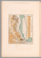
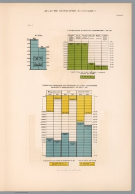
Author
Khanzadyan, Zadig
Full Title
Valeur totale des importations de Constantinople par pays de province. Dressee par Z. Khanzadian. (to accompany) Atlas de geographie economique de Turquie : par Z. Khanzadian. Editeur L. de Bertalot. 1924.
List No
13321.046
Note
Color diagrams showing total value of imports from Constantinople.
Author
[Derrick, Thomas, 1885-1954, Bawden, Edward, 1903-1989]
Full Title
London's Underground to Wembley. Thomas Derrick & Bawden. 1924. Eyre & Spottiswoode Ltd., H.M. Printers, London.
List No
13291.000
Note
"Rare pictorial map / advertising poster for promoting subway transportation to the British Empire Exhibition at Wembley. The image illustrates Wembley's Football (soccer) Stadium in the center of the image surrounded by a multitude of people, places, disciplines, and activities representing the British Empire. The artist collaborators for the image were: Edward Bawden (British, 1903–1989), a successful and prolific illustrator and graphic designer whose commissions included designs for posters, books, ceramic decorations, wallpaper, textiles, and murals and who also taught graphic design at the Royal College of Art, designed posters and ephemera for both the Underground Group and London Transport for over a quarter century. Thomas Derrick (British, 1885–1954), best known for his mural and illustration work, also painted portraits and designed stained glass. He produced posters for the Underground Group from 1924 to 1927. As noted by the entry for the map in the London Transit Museum: This poster was commissioned by the Underground in 1924. The brief was an illustrated map of the British Empire Exhibition at Wembley. Frank Pick approached Edward Bawden for the commission on the recommendation of Bawden's tutor at the Royal College of Art. Pick rejected Bawden's first proposal and brought in the more experienced designer, Thomas Derrick. Derrick handled the cartography and overall design, and Bawden was left to provide the illustrations. From a distance the poster was hard to read, but it was extremely popular with the public for its exquisite attention to detail. The map was printed in London by Eyre & Spottiswoode Ltd., H.M. Printers." (Ruderman)
Author
[Sleigh, Bernard, Dent, Robert K., Ellis, I. A., Kynoch Press]
Full Title
A picture map of Birmingham in 1730. Imagined & drawn from city records by Bernard Sleigh and lettered by I.A. Ellis. 1923. (to accompany) A picture map of the city of Birmingham in the year 1730. Imagined and designed by Bernard Sleigh from official records. Printed by the Kynoch Press A.D. 1924. and published by Cornish Bros. Limited 39 New Street. (Half title page) A picture map of the city of Birmingham in the year 1730. Imagined and designed by Bernard Sleigh; With an introductory note by Bernard Sleigh and historical notes by Robert K. Dent. (on verso) Printed and made in England at the Kynoch Press.
List No
11558.008
Note
Pictorial panoramic map of the city of Birmingham 32x47, with 6 pages of introductory note and woodblock illustration of the old Crown Inn by Bernard Sleigh and historical note by Robert K. Dent, bound in blue paper cover boards with half leather spine. Map is in full color, with decorative borders. Showing Birmingham in 18th. Century, by B. Sleigh and lettered by I.A. Ellis, depicting buildings, landmarks, roads, rivers, and farms. Includes coat of arms and historical notes.
Author
[Gill, Leslie MacDonald, 1884-1947, Pryse, Spencer, Hardie, Martin]
Full Title
The World in the Time of Cabot (1517).
List No
12108.005
Note
Includes foldout.
Author
[Birdseye, C.H., Burchard, R.W., U.S. Geological Survey]
Full Title
Sheet O. Plan and Profile of Colorado River From Lees Ferry, Ariz., To Black Canyon, Ariz.-Nev., and Virgin River, Nev. 21 Sheets (14 plans, 7 profiles).
List No
10974.016
Author
[Birdseye, C.H., Burchard, R.W., U.S. Geological Survey]
Full Title
Sheet P. Plan and Profile of Colorado River From Lees Ferry, Ariz., To Black Canyon, Ariz.-Nev., and Virgin River, Nev. 21 Sheets (14 plans, 7 profiles).
List No
10974.017
Author
[Birdseye, C.H., Burchard, R.W., U.S. Geological Survey]
Full Title
Sheet Q. Plan and Profile of Colorado River From Lees Ferry, Ariz., To Black Canyon, Ariz.-Nev., and Virgin River, Nev. 21 Sheets (14 plans, 7 profiles).
List No
10974.018
Author
[Birdseye, C.H., Burchard, R.W., U.S. Geological Survey]
Full Title
Sheet R. Plan and Profile of Colorado River From Lees Ferry, Ariz., To Black Canyon, Ariz.-Nev., and Virgin River, Nev. 21 Sheets (14 plans, 7 profiles).
List No
10974.019
Author
[Birdseye, C.H., Burchard, R.W., U.S. Geological Survey]
Full Title
Sheet S. Plan and Profile of Colorado River From Lees Ferry, Ariz., To Black Canyon, Ariz.-Nev., and Virgin River, Nev. 21 Sheets (14 plans, 7 profiles).
List No
10974.020
Author
[Birdseye, C.H., Burchard, R.W., U.S. Geological Survey]
Full Title
Sheet T. Plan and Profile of Colorado River From Lees Ferry, Ariz., To Black Canyon, Ariz.-Nev., and Virgin River, Nev. 21 Sheets (14 plans, 7 profiles).
List No
10974.021
Author
[Birdseye, C.H., Burchard, R.W., U.S. Geological Survey]
Full Title
Sheet U. Plan and Profile of Colorado River From Lees Ferry, Ariz., To Black Canyon, Ariz.-Nev., and Virgin River, Nev. 21 Sheets (14 plans, 7 profiles).
List No
10974.022
Author
[Sleigh, Bernard, Dent, Robert K., Ellis, I. A., Kynoch Press]
Full Title
(Covers to) A picture map of the city of Birmingham in the year 1730. Imagined and designed by Bernard Sleigh from official records. Printed by the Kynoch Press A.D. 1924. and published by Cornish Bros. Limited 39 New Street. (Half title page) A picture map of the city of Birmingham in the year 1730. Imagined and designed by Bernard Sleigh; With an introductory note by Bernard Sleigh and historical notes by Robert K. Dent. (on verso) Printed and made in England at the Kynoch Press. (map) A picture map of Birmingham in 1730. Imagined & drawn from city records by Bernard Sleigh and lettered by I.A. Ellis. 1923.
List No
11558.001
Note
Pictorial panoramic map of the city of Birmingham 32x47, with 6 pages of introductory note and woodblock illustration of the old Crown Inn by Bernard Sleigh and historical note by Robert K. Dent, bound in blue paper cover boards with half leather spine. Map is in full color, with decorative borders. Showing Birmingham in 18th. Century, by B. Sleigh and lettered by I.A. Ellis, depicting buildings, landmarks, roads, rivers, and farms. Includes coat of arms and historical notes.
Author
[Sleigh, Bernard, Dent, Robert K., Ellis, I. A., Kynoch Press]
Full Title
(Title Page to) A picture map of the city of Birmingham in the year 1730. Imagined and designed by Bernard Sleigh from official records. Printed by the Kynoch Press A.D. 1924. and published by Cornish Bros. Limited 39 New Street. (Half title page) A picture map of the city of Birmingham in the year 1730. Imagined and designed by Bernard Sleigh; With an introductory note by Bernard Sleigh and historical notes by Robert K. Dent. (on verso) Printed and made in England at the Kynoch Press. (map) A picture map of Birmingham in 1730. Imagined & drawn from city records by Bernard Sleigh and lettered by I.A. Ellis. 1923.
List No
11558.002
Note
Pictorial panoramic map of the city of Birmingham 32x47, with 6 pages of introductory note and woodblock illustration of the old Crown Inn by Bernard Sleigh and historical note by Robert K. Dent, bound in blue paper cover boards with half leather spine. Map is in full color, with decorative borders. Showing Birmingham in 18th. Century, by B. Sleigh and lettered by I.A. Ellis, depicting buildings, landmarks, roads, rivers, and farms. Includes coat of arms and historical notes.
Author
[Sleigh, Bernard, Dent, Robert K., Ellis, I. A., Kynoch Press]
Full Title
(Half Title Page to) A picture map of the city of Birmingham in the year 1730. Imagined and designed by Bernard Sleigh from official records. Printed by the Kynoch Press A.D. 1924. and published by Cornish Bros. Limited 39 New Street. (Half title page) A picture map of the city of Birmingham in the year 1730. Imagined and designed by Bernard Sleigh; With an introductory note by Bernard Sleigh and historical notes by Robert K. Dent. (on verso) Printed and made in England at the Kynoch Press. (map) A picture map of Birmingham in 1730. Imagined & drawn from city records by Bernard Sleigh and lettered by I.A. Ellis. 1923.
List No
11558.003
Note
Pictorial panoramic map of the city of Birmingham 32x47, with 6 pages of introductory note and woodblock illustration of the old Crown Inn by Bernard Sleigh and historical note by Robert K. Dent, bound in blue paper cover boards with half leather spine. Map is in full color, with decorative borders. Showing Birmingham in 18th. Century, by B. Sleigh and lettered by I.A. Ellis, depicting buildings, landmarks, roads, rivers, and farms. Includes coat of arms and historical notes.
Author
[Sleigh, Bernard, Dent, Robert K., Ellis, I. A., Kynoch Press]
Full Title
(Text Page to) A picture map of the city of Birmingham in the year 1730. Imagined and designed by Bernard Sleigh from official records. Printed by the Kynoch Press A.D. 1924. and published by Cornish Bros. Limited 39 New Street. (Half title page) A picture map of the city of Birmingham in the year 1730. Imagined and designed by Bernard Sleigh; With an introductory note by Bernard Sleigh and historical notes by Robert K. Dent. (on verso) Printed and made in England at the Kynoch Press. (map) A picture map of Birmingham in 1730. Imagined & drawn from city records by Bernard Sleigh and lettered by I.A. Ellis. 1923.
List No
11558.004
Note
Pictorial panoramic map of the city of Birmingham 32x47, with 6 pages of introductory note and woodblock illustration of the old Crown Inn by Bernard Sleigh and historical note by Robert K. Dent, bound in blue paper cover boards with half leather spine. Map is in full color, with decorative borders. Showing Birmingham in 18th. Century, by B. Sleigh and lettered by I.A. Ellis, depicting buildings, landmarks, roads, rivers, and farms. Includes coat of arms and historical notes.
Author
[Sleigh, Bernard, Dent, Robert K., Ellis, I. A., Kynoch Press]
Full Title
(Text Page to) A picture map of the city of Birmingham in the year 1730. Imagined and designed by Bernard Sleigh from official records. Printed by the Kynoch Press A.D. 1924. and published by Cornish Bros. Limited 39 New Street. (Half title page) A picture map of the city of Birmingham in the year 1730. Imagined and designed by Bernard Sleigh; With an introductory note by Bernard Sleigh and historical notes by Robert K. Dent. (on verso) Printed and made in England at the Kynoch Press. (map) A picture map of Birmingham in 1730. Imagined & drawn from city records by Bernard Sleigh and lettered by I.A. Ellis. 1923.
List No
11558.005
Note
Pictorial panoramic map of the city of Birmingham 32x47, with 6 pages of introductory note and woodblock illustration of the old Crown Inn by Bernard Sleigh and historical note by Robert K. Dent, bound in blue paper cover boards with half leather spine. Map is in full color, with decorative borders. Showing Birmingham in 18th. Century, by B. Sleigh and lettered by I.A. Ellis, depicting buildings, landmarks, roads, rivers, and farms. Includes coat of arms and historical notes.
Author
[Sleigh, Bernard, Dent, Robert K., Ellis, I. A., Kynoch Press]
Full Title
(Text Page to) A picture map of the city of Birmingham in the year 1730. Imagined and designed by Bernard Sleigh from official records. Printed by the Kynoch Press A.D. 1924. and published by Cornish Bros. Limited 39 New Street. (Half title page) A picture map of the city of Birmingham in the year 1730. Imagined and designed by Bernard Sleigh; With an introductory note by Bernard Sleigh and historical notes by Robert K. Dent. (on verso) Printed and made in England at the Kynoch Press. (map) A picture map of Birmingham in 1730. Imagined & drawn from city records by Bernard Sleigh and lettered by I.A. Ellis. 1923.
List No
11558.006
Note
Pictorial panoramic map of the city of Birmingham 32x47, with 6 pages of introductory note and woodblock illustration of the old Crown Inn by Bernard Sleigh and historical note by Robert K. Dent, bound in blue paper cover boards with half leather spine. Map is in full color, with decorative borders. Showing Birmingham in 18th. Century, by B. Sleigh and lettered by I.A. Ellis, depicting buildings, landmarks, roads, rivers, and farms. Includes coat of arms and historical notes.
Author
[Sleigh, Bernard, Dent, Robert K., Ellis, I. A., Kynoch Press]
Full Title
(Text Page to) A picture map of the city of Birmingham in the year 1730. Imagined and designed by Bernard Sleigh from official records. Printed by the Kynoch Press A.D. 1924. and published by Cornish Bros. Limited 39 New Street. (Half title page) A picture map of the city of Birmingham in the year 1730. Imagined and designed by Bernard Sleigh; With an introductory note by Bernard Sleigh and historical notes by Robert K. Dent. (on verso) Printed and made in England at the Kynoch Press. (map) A picture map of Birmingham in 1730. Imagined & drawn from city records by Bernard Sleigh and lettered by I.A. Ellis. 1923.
List No
11558.007
Note
Pictorial panoramic map of the city of Birmingham 32x47, with 6 pages of introductory note and woodblock illustration of the old Crown Inn by Bernard Sleigh and historical note by Robert K. Dent, bound in blue paper cover boards with half leather spine. Map is in full color, with decorative borders. Showing Birmingham in 18th. Century, by B. Sleigh and lettered by I.A. Ellis, depicting buildings, landmarks, roads, rivers, and farms. Includes coat of arms and historical notes.
Author
Ruep, Joseph
Full Title
(Covers to) Carta a Relievo Plastico Automobilistica delle Dolomiti (Italia). Publicata Dall' Hotel Karersee Carezza al Lago, Dolomiti (Italia).
List No
12105.001
Note
Printed on back of map.
Author
Ruep, Joseph
Full Title
Carta a Relievo Plastico Automobilistica delle Dolomiti (Italia). Publicata Dall' Hotel Karersee Carezza al Lago, Dolomiti (Italia).
List No
12105.002
Author
[Lucas, E.V., Gill, Leslie MacDonald, 1884-1947, Brangwyn, Frank, Pryse, Spencer, Hardie, Martin]
Full Title
(Covers to) Pageant of British Empire, Souvenir Volume ... An Anthology of British Empire by E.V. Lucas ... Illustrations by Frank Brangwyn, R.A., Spencer Pryse and MacDonald Gill ... 1924 ... Printed and Published by Fleetway Press Ltd., Dane Street, High Holborn, W.C.I.
List No
12108.001
Author
[Lucas, E.V., Gill, Leslie MacDonald, 1884-1947, Brangwyn, Frank, Pryse, Spencer, Hardie, Martin]
Full Title
(Text Page) (Stanza by Col. Mordaunt.)
List No
12108.002
Author
[Lucas, E.V., Gill, Leslie MacDonald, 1884-1947, Brangwyn, Frank, Pryse, Spencer, Hardie, Martin]
Full Title
(Title Page) Pageant of British Empire, Souvenir Volume ... An Anthology of British Empire by E.V. Lucas ... Illustrations by Frank Brangwyn, R.A., Spencer Pryse and MacDonald Gill ... 1924 ... Printed and Published by Fleetway Press Ltd., Dane Street, High Holborn, W.C.I.
List No
12108.003
Author
[Lucas, E.V., Gill, Leslie MacDonald, 1884-1947, Brangwyn, Frank, Pryse, Spencer, Hardie, Martin]
Full Title
(Composite Text) Pageant of British Empire, Souvenir Volume ... An Anthology of British Empire by E.V. Lucas ... Illustrations by Frank Brangwyn, R.A., Spencer Pryse and MacDonald Gill ... 1924 ... Printed and Published by Fleetway Press Ltd., Dane Street, High Holborn, W.C.I.
List No
12108.004
Note
Includes foldout.
Author
[Daidy, George A., Bauman Jr., Wm., Berthrong, I.P., U.S. General Land Office]
Full Title
State of Washington. General Land Office.
List No
12408.000
Author
Kremers, Laura
Full Title
A historical map of Madison. Designed by Laura Kremers of the Colt Studio of Commercial Art, Madison, Wisconsin.
List No
13282.000
Author
Khanzadyan, Zadig
Full Title
(Covers to) Atlas de geographie economique de Turquie : par Z. Khanzadian. Editeur L. de Bertalot. 1924.
List No
13321.001
Author
Khanzadyan, Zadig
Full Title
(Half Title Page to) Atlas de geographie economique de Turquie : par Z. Khanzadian. Editeur L. de Bertalot. 1924.
List No
13321.003
Author
Khanzadyan, Zadig
Full Title
(Text Page to) Atlas de geographie economique de Turquie : par Z. Khanzadian. Editeur L. de Bertalot. 1924.
List No
13321.004
Author
Khanzadyan, Zadig
Full Title
(Text Page to) Atlas de geographie economique de Turquie : par Z. Khanzadian. Editeur L. de Bertalot. 1924.
List No
13321.005
Author
Khanzadyan, Zadig
Full Title
(Text Page to) Atlas de geographie economique de Turquie : par Z. Khanzadian. Editeur L. de Bertalot. 1924.
List No
13321.006
Author
Khanzadyan, Zadig
Full Title
(Text Page to) Atlas de geographie economique de Turquie : par Z. Khanzadian. Editeur L. de Bertalot. 1924.
List No
13321.007
Author
Khanzadyan, Zadig
Full Title
(Text Page to) Atlas de geographie economique de Turquie : par Z. Khanzadian. Editeur L. de Bertalot. 1924.
List No
13321.008
Author
Khanzadyan, Zadig
Full Title
(Text Page to) Atlas de geographie economique de Turquie : par Z. Khanzadian. Editeur L. de Bertalot. 1924.
List No
13321.009
Author
Khanzadyan, Zadig
Full Title
(Text Page to) Atlas de geographie economique de Turquie : par Z. Khanzadian. Editeur L. de Bertalot. 1924.
List No
13321.010
Author
Khanzadyan, Zadig
Full Title
(Text Page to) Atlas de geographie economique de Turquie : par Z. Khanzadian. Editeur L. de Bertalot. 1924.
List No
13321.011
Author
Khanzadyan, Zadig
Full Title
(Text Page to) Atlas de geographie economique de Turquie : par Z. Khanzadian. Editeur L. de Bertalot. 1924.
List No
13321.012
Author
Khanzadyan, Zadig
Full Title
(Text Page to) Atlas de geographie economique de Turquie : par Z. Khanzadian. Editeur L. de Bertalot. 1924.
List No
13321.013
Note
Continues: Climate. Natural resources.
Author
Khanzadyan, Zadig
Full Title
(Text Page to) Atlas de geographie economique de Turquie : par Z. Khanzadian. Editeur L. de Bertalot. 1924.
List No
13321.014
Note
Natural resources.
Author
Khanzadyan, Zadig
Full Title
(Text Page to) Atlas de geographie economique de Turquie : par Z. Khanzadian. Editeur L. de Bertalot. 1924.
List No
13321.015
Note
Natural resources.
Author
Khanzadyan, Zadig
Full Title
(Text Page to) Atlas de geographie economique de Turquie : par Z. Khanzadian. Editeur L. de Bertalot. 1924.
List No
13321.016
Note
Continues: Natural resources. Industry and trade.
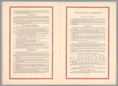
Author
Khanzadyan, Zadig
Full Title
(Text Page to) Atlas de geographie economique de Turquie : par Z. Khanzadian. Editeur L. de Bertalot. 1924.
List No
13321.017
Note
Continues: Industry and trade.
Author
Khanzadyan, Zadig
Full Title
(Text Page to) Atlas de geographie economique de Turquie : par Z. Khanzadian. Editeur L. de Bertalot. 1924.
List No
13321.018
Note
Continues: Industry and trade. Annexe: List of submitted articles.
Author
Khanzadyan, Zadig
Full Title
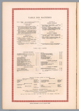
(Contents to) Atlas de geographie economique de Turquie : par Z. Khanzadian. Editeur L. de Bertalot. 1924.
List No
13321.019
Note
Table of contents.
Author
Khanzadyan, Zadig
Full Title
Cartes historiques des geographes musulmans : Les possessions de l'Empire Ottoman en Europe = Uruppa. Imp. Gaillac - Monrocq et Cie. Paris. Atlas de Kiatib - Tchelebi, 1700. (to accompany) Atlas de geographie economique de Turquie : par Z. Khanzadian. Editeur L. de Bertalot. 1924.
List No
13321.021
Note
Color map of the possessions of the Ottoman Empire in Europe. Includes decorative title cartouche. In Franche and Ottoman Turkish languages. Relief shown by hachures and pictorially.
Author
Khanzadyan, Zadig
Full Title
Cartes historiques : Dulcert 1330. Villadeste 1350. Atlas Atlas de geographie economique, par Z. Khanzadian. (to accompany) Atlas Atlas de geographie economique.de Turquie : Editeur L. de Bertalot. 1924.
List No
13321.022
Note
2 black and white nautical charts of Ottoman Empire, on one sheet 55x37.
Author
Khanzadyan, Zadig
Full Title
Cartes historiques des geographes Occidentaux. Turcici Imperii Descriptio. Ortelius, 1580. (to accompany) Atlas de geographie economique de Turquie : par Z. Khanzadian. Editeur L. de Bertalot. 1924.
List No
13321.024
Note
Historical map of Western geographers. Ortelius map of the Turkish Empire, covering the Middle East, Turkey and the Eastern Mediterranean from Sicily to Cyprus. Includes ornate title cartouche, sailing vessels, a sea monster in the Black Sea and descriptive notes on the map.
Author
Khanzadyan, Zadig
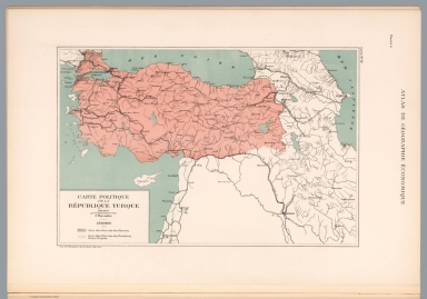
Full Title
Carte politique de la Turque. Dressee Z. Khanzadyan. Grave chez P. Monsanglant, Paris. (to accompany) Atlas de geographie economique de Turquie : par Z. Khanzadian. Editeur L. de Bertalot. 1924.
List No
13321.025
Note
Political map of Turkey. Shows boundaries, roads, railroads, major cities, rivers and lakes. Includes legend.
Author
Khanzadyan, Zadig
Full Title
Turquie d'Asie. Dressee par Z. Khanzadian. Grave chez P. Monsanglant, Paris. (to accompany) Atlas de geographie economique de Turquie : par Z. Khanzadian. Editeur L. de Bertalot. 1924.
List No
13321.027
Note
Color map of Asia Minor. Shows Longitudinal Lines, isotherm lines depict the air temperature in winter and summer. Includes legend.
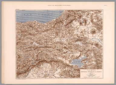
Author
Khanzadyan, Zadig
Full Title
Carte physique des provinces orientales de Turquie. Dressee par Z. Khanzadian. Grave chez P. Monsanglant, Paris. (to accompany) Atlas de geographie economique de Turquie : par Z. Khanzadian. Editeur L. de Bertalot. 1924.
List No
13321.028
Note
Physical map of eastern provinces of Turkey. Relief shown by contours, shadings and spot heights. Shows major cities, towns, rivers and lakes.
Author
Khanzadyan, Zadig
Full Title
Kars. Dressee par Z. Khanzadian. Grave chez P. Monsanglant, Paris. (to accompany) Atlas de geographie economique de Turquie : par Z. Khanzadian. Editeur L. de Bertalot. 1924.
List No
13321.029
Note
Color map of the area around the city of Kars in northeastern Turkey. Relief shown by shadings. Shows major towns, roads, trails and rivers.
Author
Khanzadyan, Zadig
Full Title
Erzeroum. Dressee par Z. Khanzadian. Imp. Gaillac - Monrocq et Cie, Paris. (to accompany) Atlas de geographie economique de Turquie : par Z. Khanzadian. Editeur L. de Bertalot. 1924.
List No
13321.030
Note
Color map of the area around the city of Erzurum. Relief shown by shadings. Shows major towns, roads, trails and rivers.
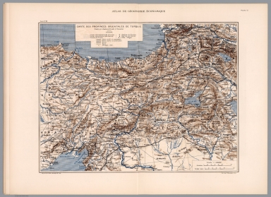
Author
Khanzadyan, Zadig
Full Title
Carte des provinces Orientales de Turquie. Dressee par Z. Khanzadian. Imp. Gaillac - Monrocq et Cie, Paris. Lith, chez P. Monsanglant, Paris. (to accompany) Atlas de geographie economique de Turquie : par Z. Khanzadian. Editeur L. de Bertalot. 1924.
List No
13321.031
Note
Color map of eastern provinces of Turkey. Relief shown by shadings. Shows administrative boundaries, capitals, major cities, towns, roads, railroads, rivers, tunnels, and lakes. Includes legend.
Author
Khanzadyan, Zadig
Full Title
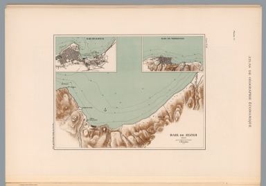
Baie de Rizeh. Dressee par Z. Khanzadian. Imp. Gaillac - Monrocq et Cie, Paris. (to accompany) Atlas de geographie economique de Turquie : par Z. Khanzadian. Editeur L. de Bertalot. 1924.
List No
13321.032
Note
Color map of Rize Bay, with insets: Baie de Batoum and Baie de Trebizonde, cities on Black Sea coast of northeastern Turkey. Relief shown by contours and shadings. Depths shown by soundings and isolines.
Author
Khanzadyan, Zadig
Full Title
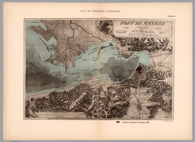
Port de Smyrne, 1909-1913. Dressee par Z. Khanzadian. d'apres les travaux des commandants Richard Coppeland (1834) Spratt (1859) de l'Amiraute Anglaise, de Ch. Ploix (1866) Ingr. Hydrographe de la Marine Francaise. Helio Paul et Vigier, Paris. (to accompany) Atlas de geographie economique de Turquie : par Z. Khanzadian. Editeur L. de Bertalot. 1924.
List No
13321.033
Note
Color map of Port of Izmir, according to the work of the commanders richard coppeland 1834 Spratt 1859 of the British Admiralty, of Ch. Ploix (1866) Ingr. Hydrographer of the French Navy. Relief shown by shadings and spot heights. Depths shown by soundings and isolines. Map shows roads, railroads and the burned area in September 1922.
Author
Khanzadyan, Zadig
Full Title
Rade de Mersina. Dressee par Z. Khanzadian. (to accompany) Atlas de geographie economique de Turquie : par Z. Khanzadian. Editeur L. de Bertalot. 1924.
List No
13321.034
Note
Color map of city and port of Mersin on the Mediterranean coast of southern Turkey, with inset: Adana. Relief shown by contours and spot heights. Depths shown by soundings and isolines. Map shows settlements and roads.
Author
Khanzadyan, Zadig
Full Title
Carte de trace des routes de Trebizonde et des environs. Dressee par Z. Khanzadian. (to accompany) Atlas de geographie economique de Turquie : par Z. Khanzadian. Editeur L. de Bertalot. 1924.
List No
13321.035
Note
Color road map of city of Trabzon and surroundings on the Black Sea coast of northeast Turkey. Map shows settlements, roads, forests and rivers. Relief shown by contours.
Author
Khanzadyan, Zadig
Full Title
Carte de trace des routes d' Erzindjan : depuis sa jonction a celle de Trebizonde-Erzeroum. Dressee par Z. Khanzadian. Grave chez P. Monsanglant, Paris. Imp. Gaillac - Monrocq et Cie, Paris. (to accompany) Atlas de geographie economique de Turquie : par Z. Khanzadian. Editeur L. de Bertalot. 1924.
List No
13321.036
Note
Color road map of city of Erzindjan (Erzincan), from its junction to that of Trabzon-Erzurum. Map shows roads, forests and rivers. Relief shown by contours.
Author
Khanzadyan, Zadig
Full Title
Turquie d' Asie. Dressee par Z. Khanzadian. Le projet Chester. Grave chez P. Monsanglant, Paris. Imp. Gaillac - Monrocq et Cie, Paris. (to accompany) Atlas de geographie economique de Turquie : par Z. Khanzadian. Editeur L. de Bertalot. 1924.
List No
13321.038
Note
Color map and Turkey in Asia. Red lines show the Railroad for Turkey: the Chester Project, 1908–1913. Map shows roads, railroads, rivers, and major cities.
Author
Khanzadyan, Zadig
Full Title
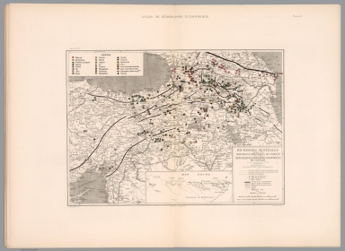
Richesses minerales dans les provinces Orientales de Turquie, Republiques Socialistes Sovietiques du Caucase. Dressee par Z. Khanzadian. P. Monsanglant, Lith. Chichmanian et Bahry. Del. Imp. Monrocq, Paris. (to accompany) Atlas de geographie economique de Turquie : par Z. Khanzadian. Editeur L. de Bertalot. 1924.
List No
13321.039
Note
Color map of mines and mineral resources in the eastern provinces of Turkey and Republic of Caucasus, with inset: Province de Kastamouni. Map shows political and administrative boundaries, major cities, towns, roads, railroads, rivers and tunnels. Includes explanations and legend. Prime meridian is Greenwich.
Author
Khanzadyan, Zadig
Full Title
Turque d' Asie. Dressee par Z. Khanzadian. Exploitations minieres. Graved P. Monsanglant, Paris. Imp. Monrocq, Paris. (to accompany) Atlas de geographie economique de Turquie : par Z. Khanzadian. Editeur L. de Bertalot. 1924.
List No
13321.040
Note
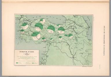
Color map of mining operations in Asia Minor. Shows salt, coal and chromium production and location of mines.
Author
Khanzadyan, Zadig
Full Title
Turque d' Asie. Dressee par Z. Khanzadian. Carte des superficies en kilometres carres des provinces de Turquie d' Asie, des terrains cultivables et incultes. Graved P. Monsanglant, Paris. Imp. Monrocq, Paris. (to accompany) Atlas de geographie economique de Turquie : par Z. Khanzadian. Editeur L. de Bertalot. 1924.
List No
13321.041
Note
Color map of the cultivated areas in provinces of Turkey in Asia. Includes color coded legend.
Author
Khanzadyan, Zadig
Full Title
Turque d' Asie. Dressee par Z. Khanzadian. Production de cereales, legumes secs et fruits en Turquie d' Asie. Graved P. Monsanglant, Paris. Imp. Monrocq, Paris. (to accompany) Atlas de geographie economique de Turquie : par Z. Khanzadian. Editeur L. de Bertalot. 1924.
List No
13321.042
Note
Color map of the production of cereals, dried vegetables and fruits in Turkey. With inset: Principaux centres de la production mondiale. Includes color coded legend.
Author
Khanzadyan, Zadig
Full Title
Turque d' Asie. Dressee par Z. Khanzadian. Production du tabac, coton et soie. Graved P. Monsanglant, Paris. Imp. Monrocq, Paris. (to accompany) Atlas de geographie economique de Turquie : par Z. Khanzadian. Editeur L. de Bertalot. 1924.
List No
13321.043
Note
Color map of the production of tobacco, cotton and silk in Turkey. Includes color coded legend.
Author
Khanzadyan, Zadig
Full Title
Turque d' Asie. Dressee par Z. Khanzadian. Carte des forets. Graved P. Monsanglant, Paris. Imp. Monrocq, Paris. (to accompany) Atlas de geographie economique de Turquie : par Z. Khanzadian. Editeur L. de Bertalot. 1924.
List No
13321.044
Note
Color map of the forests in Turkey. Includes color coded legend.
Author
Khanzadyan, Zadig
Full Title
Alcool. l' importations huiles a Constantinople en 1921. Statistique graphiquedes cottonnades et laines d' Angleterre. Imports a Constantinople en 1920-1921. Dressee par Z. Khanzadian. (to accompany) Atlas de geographie economique de Turquie : par Z. Khanzadian. Editeur L. de Bertalot. 1924.
List No
13321.047
Note
Color diagrams showing imports from and to Constantinople, in 1920-1921.
Author
Khanzadyan, Zadig
Full Title
Statistique graphique des exportations et importation en Turquie de 1884-1923 . Dressee par Z. Khanzadian. (to accompany) Atlas de geographie economique de Turquie : par Z. Khanzadian. Editeur L. de Bertalot. 1924.
List No
13321.048
Note
Graphic chart of exports and imports to Turkey from 1884-1923.
Author
Khanzadyan, Zadig
Full Title
Sous presse. (to accompany) Atlas de geographie economique de Turquie : par Z. Khanzadian. Editeur L. de Bertalot. 1924.
List No
13321.049
Note
Publisher advertisement.
Author
Clegg, Ernest
Full Title
Mappa aestivarum Insularum alias Barmudas dictarum ... Ernest Clegg - New York - 1924. From the painting by Ernest Clegg. Country Life Print.
List No
13480.000
Author
Rand McNally and Company
Full Title
(Covers to) Rand McNally Commercial Atlas Of America. Fifty-Fifth Edition ... Engraved, Printed, And Published By Rand McNally & Company, Chicago, U.S.A., 1924. (on verso) ... Copyright, 1924, by Rand, McNally & Co. Made In U.S.A.
List No
5028A
Note
Bound in dark green cloth covered boards with "Rand McNally & Co's Commercial Atlas Of America. Fifty-Fifth Edition 1924 ..." with generalized table of contents. Spine is printed with the same title.
Author
Rand McNally and Company
Full Title
(Table of Contents on Front and Back Lining to) Rand McNally Commercial Atlas Of America. Fifty-Fifth Edition ... Engraved, Printed, And Published By Rand McNally & Company, Chicago, U.S.A., 1924. (on verso) ... Copyright, 1924, by Rand, McNally & Co. Made In U.S.A.
List No
5028B
Note
Also repeated on the back cover lining.
Author
Rand McNally and Company
Full Title
(Title Page to) Fifty-Fifth Edition. Rand McNally Commercial Atlas of America ... Engraved, Printed, And Published By Rand McNally & Company, Chicago, U.S.A., 1924.
List No
5028C
Note
Includes several paragraphs descriptive of the atlas contents.
Author
Rand McNally and Company
Full Title
(Title Page verso to) Fifty-Fifth Edition. Rand McNally Commercial Atlas of America ... Engraved, Printed, And Published By Rand McNally & Company, Chicago, U.S.A., 1924.
List No
5028D
Note
Includes descriptions of map details and abbeviations.
Author
Rand McNally and Company
Full Title
(Table of Contents to) Fifty-Fifth Edition. Rand McNally Commercial Atlas of America ... Engraved, Printed, And Published By Rand McNally & Company, Chicago, U.S.A., 1924.
List No
5028E
Note
Alphabetical table of contents.
Author
Rand McNally and Company
Full Title
(Text Page) Commercial Atlas of America. The World. Principal Countries - Leading Products, Exports, Imports, and Ports.
List No
5028F
Author
Rand McNally and Company
Full Title
The World on Mercator's Projection.
List No
5028.001
Note
Shows marine telegraph and cable lines, currents, steam vessel tracks, and nautical distances.
Author
Rand McNally and Company
Full Title
(Text Page) Commercial Atlas of America. Alphabetical List of Steamship and Steamboat Lines.
List No
5028G
Note
International listing.
Author
Rand McNally and Company
Full Title
Commercial Atlas of America. Rand McNally, The Steamship Routes of The World.
List No
5028.002
Note
Includes several tables of distances between steamship destinations.
Author
Rand McNally and Company
Full Title
(Text Page) Commercial Atlas of America. Alphabetical List of Steamship and Steamboat Lines. Ocean Steamships from Export and Import Shipping Ports.
List No
5028H
Note
International listing. Import and export ports are listed by American city.
Author
Rand McNally and Company
Full Title
Commercial Atlas of America. Rand McNally, 14 x 21 Inch Map of North America.
List No
5028.003
Note
Inset is an extension of map. Relief shown by hachures.
Author
Rand McNally and Company
Full Title
Commercial Atlas of America. Rand McNally, Standard Map of United States.
List No
5028.004
Note
Shows standard railroad time zones and freight rate zones. Relief shown by hachures.
Author
Rand McNally and Company
Full Title
Commercial Atlas of America. Rand McNally, 14 x 21 inch Industrial Map of the United States.
List No
5028.005
Note
Shows broad and localized product zones including petroleum areas. Relief shown by hachures.
Author
Rand McNally and Company
Full Title
(Text Page) Commercial Atlas of America. Principal Cities of the United States Numerically Arranged with 1920 Census Population.
List No
5028I
Author
Rand McNally and Company
Full Title
(Text Page) Commercial Atlas of America. Principal Cities of the United States Numerically Arranged at Each Census, 1890 to 1920. Principal Cities of the United States, Numerically Arranged, by States.
List No
5028J
Author
Rand McNally and Company
Full Title
(Text Page) Commercial Atlas of America. Principal Cities of the United States, Numerically Arranged - Continued.
List No
5028K
Author
Rand McNally and Company
Full Title
Commercial Atlas of America. Black and White Mileage Map of the United States (eastern half).
List No
5028.006
Note
Shows railroad lines and destinations.
Author
Rand McNally and Company
Full Title
(Text Page) Commercial Atlas of America. Principal Cities of the United States, Numerically Arranged - Continued. Number of Cities and Villages in the United States. Canals of the United States. Shortest Railroad Travel Distance Tables of the United States.
List No
5028L
Note
Number of cities and railroad travel distance tables by states. International travel distance tables by states.
Author
Rand McNally and Company
Full Title
Commercial Atlas of America. Black and White Mileage Map of the United States (western half).
List No
5028.007
Note
Shows railroad lines and destinations.
Author
Rand McNally and Company
Full Title
(Composite of) Commercial Atlas of America. Black and White Mileage Map of the United States.
List No
5028.008
Note
Shows railroad lines and destinations.
Author
Rand McNally and Company
Full Title
(Text Page) Commercial Atlas of America. Shortest Railroad Travel Distance Tables of the United States.
List No
5028M
Note
International travel distance tables by states.
Author
Rand McNally and Company
Full Title
Commercial Atlas of America. (United States) East of Chicago.
List No
5028.009
Note
Insets are extensions of map. Relief shown by hachures.
Author
Rand McNally and Company
Full Title
(Text Page) Commercial Atlas of America. Shortest Railroad Travel Distance Tables of the United States.
List No
5028N
Note
International travel distance tables by states.
Author
Rand McNally and Company
Full Title
(Text Page) Commercial Atlas of America. Travel Distance Table.
List No
5028O
Note
Travel distance tables including some overseas destinations.
Author
Rand McNally and Company
Full Title
Commercial Atlas of America. (United States) Denver to Chicago.
List No
5028.01
Note
Relief shown by hachures.
Author
Rand McNally and Company
Full Title
Commercial Atlas of America. (United States. Population Attributes).
List No
5028.011
Note
Four thematic maps showing values by state, in black and white.
Author
Rand McNally and Company
Full Title
Commercial Atlas of America. (United States) Denver to Pacific Coast.
List No
5028.012
Note
Relief shown by hachures.
Author
Rand McNally and Company
Full Title
Commercial Atlas of America. (United States. Population Attributes).
List No
5028.013
Note
Four thematic maps showing values by state, in black and white.
Author
Rand McNally and Company
Full Title
Commercial Atlas of America. Rand McNally Standard Parcel Post Map of the United States.
List No
5028.014
Note
Includes table showing rates of parcel postage.
Author
Rand McNally and Company
Full Title
(Text Page) Postal Information. Domestic Parcel Post. Alphabetical List of All Railroads.
List No
5028P
Note
Railroads include United States, Canada, Mexico, Cuba, Puerto Rico, and Hawaii.
Author
Rand McNally and Company
Full Title
(Text Page) Alphabetical List of All Railroads.
List No
5028Q
Note
Railroads include Canada, Mexico, Cuba, Puerto Rico, and Hawaii.
Author
Rand McNally and Company
Full Title
(Text Page) Alphabetical List of All Railroads.
List No
5028R
Note
Railroads include Canada, Mexico, Cuba, Puerto Rico, and Hawaii.
Author
Rand McNally and Company
Full Title
(Text Page) Alphabetical List of All Railroads.
List No
5028S
Note
Railroads include Canada, Mexico, Cuba, Puerto Rico, and Hawaii.
Author
Rand McNally and Company
Full Title
(Text Page) Alphabetical List of All Railroads.
List No
5028T
Note
Railroads include Canada, Mexico, Cuba, Puerto Rico, and Hawaii.
Author
Rand McNally and Company
Full Title
(Text Page) Alphabetical List of All Railroads. Railroads Grouped by Systems.
List No
5028U
Note
Railroads include Canada, Mexico, Cuba, Puerto Rico, and Hawaii.
Author
Rand McNally and Company
Full Title
(Text Page) Common Names for Railroads and Rail Systems. Miles of Railroads in Operation in the United States, 1830-1922. Miles of Railroads in Operation in Each State, January 1923. Industrial Statistics of the United States. Alabama. Arizona.
List No
5028V
Note
Industrial statistics by state and county including county seat, area, and statistics on population, agriculture and manufacturing. Includes descriptions of mines, quarries, and wells.
Author
Rand McNally and Company
Full Title
(Text Page) Industrial Statistics of the United States. Arkansas. California. Colorado.
List No
5028W
Note
Industrial statistics by state and county including county seat, area, and statistics on population, agriculture and manufacturing. Includes descriptions of mines, quarries, and wells.
Author
Rand McNally and Company
Full Title
(Text Page) Industrial Statistics of the United States. Connecticut. Delaware. Dist. of Columbia. Florida. Georgia.
List No
5028X
Note
Industrial statistics by state and county including county seat, area, and statistics on population, agriculture and manufacturing. Includes descriptions of mines, quarries, and wells.
Author
Rand McNally and Company
Full Title
(Text Page) Industrial Statistics of the United States. Idaho. Illinois. Indiana.
List No
5028Y
Note
Industrial statistics by state and county including county seat, area, and statistics on population, agriculture and manufacturing. Includes descriptions of mines, quarries, and wells.
Author
Rand McNally and Company
Full Title
(Text Page) Industrial Statistics of the United States. Iowa. Kansas.
List No
5028Z
Note
Industrial statistics by state and county including county seat, area, and statistics on population, agriculture and manufacturing. Includes descriptions of mines, quarries, and wells.
Author
Rand McNally and Company
Full Title
(Text Page) Industrial Statistics of the United States. Kentucky. Louisiana. Maine.
List No
5028AA
Note
Industrial statistics by state and county including county seat, area, and statistics on population, agriculture and manufacturing. Includes descriptions of mines, quarries, and wells.
Author
Rand McNally and Company
Full Title
(Text Page) Industrial Statistics of the United States. Maryland. Massachusetts. Michigan. Minnesota.
List No
5028AB
Note
Industrial statistics by state and county including county seat, area, and statistics on population, agriculture and manufacturing. Includes descriptions of mines, quarries, and wells.
Author
Rand McNally and Company
Full Title
(Text Page) Industrial Statistics of the United States. Minnesota. Mississippi. Missouri. Montana.
List No
5028AC
Note
Industrial statistics by state and county including county seat, area, and statistics on population, agriculture and manufacturing. Includes descriptions of mines, quarries, and wells.
Author
Rand McNally and Company
Full Title
(Text Page) Industrial Statistics of the United States. Montana. Nebraska. Nevada. New Hampshire. New Jersey.
List No
5028AD
Note
Industrial statistics by state and county including county seat, area, and statistics on population, agriculture and manufacturing. Includes descriptions of mines, quarries, and wells.
Author
Rand McNally and Company
Full Title
(Text Page) Industrial Statistics of the United States. New Mexico. New York. North Carolina.
List No
5028AE
Note
Industrial statistics by state and county including county seat, area, and statistics on population, agriculture and manufacturing. Includes descriptions of mines, quarries, and wells.
Author
Rand McNally and Company
Full Title
(Text Page) Industrial Statistics of the United States. North Dakota. Ohio. Oklahoma.
List No
5028AF
Note
Industrial statistics by state and county including county seat, area, and statistics on population, agriculture and manufacturing. Includes descriptions of mines, quarries, and wells.
Author
Rand McNally and Company
Full Title
(Text Page) Industrial Statistics of the United States. Oregon. Pennsylvania. Rhode Island. South Carolina. South Dakota.
List No
5028AG
Note
Industrial statistics by state and county including county seat, area, and statistics on population, agriculture and manufacturing. Includes descriptions of mines, quarries, and wells.
Author
Rand McNally and Company
Full Title
(Text Page) Industrial Statistics of the United States. South Dakota. Tennessee. Texas.
List No
5028AH
Note
Industrial statistics by state and county including county seat, area, and statistics on population, agriculture and manufacturing. Includes descriptions of mines, quarries, and wells.
Author
Rand McNally and Company
Full Title
(Text Page) Industrial Statistics of the United States. Texas. Utah. Vermont.
List No
5028AI
Note
Industrial statistics by state and county including county seat, area, and statistics on population, agriculture and manufacturing. Includes descriptions of mines, quarries, and wells.
Author
Rand McNally and Company
Full Title
(Text Page) Industrial Statistics of the United States. Virginia. Washington. West Virginia.
List No
5028AJ
Note
Industrial statistics by state and county including county seat, area, and statistics on population, agriculture and manufacturing. Includes descriptions of mines, quarries, and wells.
Author
Rand McNally and Company
Full Title
(Text Page) Industrial Statistics of the United States. Wisconsin. Wyoming. Maine - Counties, Islands, Lakes, Ponds, Rivers, Towns.
List No
5028AK
Note
Industrial statistics by state and county including county seat, area, and statistics on population, agriculture and manufacturing. Includes descriptions of mines, quarries, and wells. Geographical features keyed to map; populations of towns.
Author
Rand McNally and Company
Full Title
Commercial Atlas of America. Rand McNally Standard Map of Maine.
List No
5028.015
Note
Relief shown by hachures. Shows river navigability. List of railroads keyed to map. List of principal cities keyed to map.
Author
Rand McNally and Company
Full Title
(Text Page) Maine - Counties, Islands, Lakes, Ponds, Rivers, Towns.
List No
5028AL
Note
Geographical features keyed to map; populations of towns. List of electric rail lines.
Author
Rand McNally and Company
Full Title
Commercial Atlas of America. Rand McNally Auto Trails Map District No. 6. New England. Eastern New York.
List No
5028.016
Note
Inset extension of main map. Key to Trail Markings and numbers provided. Black and white.
Author
Rand McNally and Company
Full Title
Commercial Atlas of America. Rand McNally Black and White Mileage Map, Maine.
List No
5028.017
Author
Rand McNally and Company
Full Title
(Text Page) New Hampshire - Counties, Islands, Lakes, Ponds, Rivers, Mountains, Towns.
List No
5028AM
Note
Geographical features keyed to map; populations of towns.
Author
Rand McNally and Company
Full Title
Commercial Atlas of America. Rand McNally Standard Map of New Hampshire.
List No
5028.018
Note
Relief shown by hachures. Shows river navigability. List of railroads keyed to map. List of principal cities keyed to map.
Author
Rand McNally and Company
Full Title
(Text Page) New Hampshire - Counties, Islands, Lakes, Ponds, Rivers, Mountains, Towns.
List No
5028AN
Note
Geographical features keyed to map; populations of towns. List of electric rail lines.
Author
Rand McNally and Company
Full Title
Commercial Atlas of America. Rand McNally Black and White Mileage Map, New Hampshire and Vermont.
List No
5028.019
Author
Rand McNally and Company
Full Title
Commercial Atlas of America. Rand McNally Standard Map of Vermont.
List No
5028.020
Note
Relief shown by hachures. Shows river navigability. List of railroads keyed to map. List of principal cities keyed to map.
Author
Rand McNally and Company
Full Title
(Text Page) Vermont - Counties, Creeks, Islands, Lakes, Mountains, Rivers, and Towns. Massachusetts - Counties, Islands, Lakes, Mountains, Rivers, and Towns.
List No
5028AO
Note
Geographical features keyed to map; populations of towns. List of electric rail lines.
Author
Rand McNally and Company
Full Title
Commercial Atlas of America. Rand McNally Standard Map of Massachusetts. (with) Environs of Boston.
List No
5028.021
Note
Relief shown by hachures. Shows river navigability. List of railroads keyed to map. List of principal cities keyed to map. Boston inset at 1:142,000.
Author
Rand McNally and Company
Full Title
(Text Page) Massachusetts - Counties, Islands, Lakes, Mountains, Rivers, and Towns.
List No
5028AP
Note
Geographical features keyed to map; populations of towns. List of electric rail lines.
Author
Rand McNally and Company
Full Title
Commercial Atlas of America. Rand McNally Black and White Mileage Map, Connecticut, Massachusetts, and Rhode Island.
List No
5028.022
Note
Lists of principal cities keyed to map.
Author
Rand McNally and Company
Full Title
Commercial Atlas of America. Rand McNally Standard Map of Boston and Vicinity. (with) Business Portion of Boston.
List No
5028.023
Author
Rand McNally and Company
Full Title
Commercial Atlas of America. Rand McNally Standard Map of Connecticut.
List No
5028.024
Note
Relief shown by hachures. Shows river navigability. List of railroads keyed to map. List of principal cities keyed to map.
Author
Rand McNally and Company
Full Title
(Text Page) Connecticut - Counties, Islands, Lakes, Mountains, Rivers, and Towns.
List No
5028AQ
Note
Geographical features keyed to map; populations of towns. List of electric rail lines.
Author
Rand McNally and Company
Full Title
Commercial Atlas of America. Rand McNally Standard Map of Rhode Island. (with) Block Island.
List No
5028.025
Note
Relief shown by hachures. Shows river navigability. List of railroads keyed to map. List of principal cities keyed to map.
Author
Rand McNally and Company
Full Title
(Text Page) Rhode Island - Counties, Hills, Ponds, rivers, Towns, etc. New York - Counties, Islands, Lakes, Mountains, Rivers, and Towns.
List No
5028AR
Note
Geographical features keyed to map; populations of towns. List of electric rail lines.
Author
Rand McNally and Company
Full Title
Commercial Atlas of America. Rand McNally Standard Map of New York (eastern section). (with) Long Island Extension.
List No
5028.026
Note
Relief shown by hachures. Shows river navigability. List of railroads keyed to map. List of principal cities keyed to map. Inset extension of main map.
Author
Rand McNally and Company
Full Title
(Text Page) New York - Counties, Islands, Lakes, Mountains, Rivers, and Towns.
List No
5028AS
Note
Geographical features keyed to map; populations of towns. List of electric rail lines.
Author
Rand McNally and Company
Full Title
Commercial Atlas of America. Rand McNally Standard Map of New York (western and northern sections).
List No
5028.027
Note
Relief shown by hachures. Shows river navigability. List of railroads keyed to map. List of principal cities keyed to map. Inset extension of main map.
Author
Rand McNally and Company
Full Title
(Text Page) New York - Counties, Islands, Lakes, Mountains, Rivers, and Towns.
List No
5028AT
Note
Geographical features keyed to map; populations of towns. List of electric rail lines.
Author
Rand McNally and Company
Full Title
Commercial Atlas of America. Rand McNally Black and White Mileage Map, New York.
List No
5028.028
Note
Lists of principal cities keyed to map. Insets extensions of main map.
Author
Rand McNally and Company
Full Title
(Text Page) New York - Counties, Islands, Lakes, Mountains, Rivers, and Towns.
List No
5028AU
Note
Geographical features keyed to map; populations of towns. List of electric rail lines.
Author
Rand McNally and Company
Full Title
Commercial Atlas of America. Rand McNally Standard Map of Manhattan and Business Districts of Bronx, Brooklyn and Jersey City. (with) Greater New York.
List No
5028.029
Note
Shows subways, railways, and ferries.
Author
Rand McNally and Company
Full Title
Commercial Atlas of America. Rand McNally 14 x 21 Inch Map of Buffalo and Vicinity.
List No
5028.030
Author
Rand McNally and Company
Full Title
(Text Page) New Jersey - Counties, Brooks, Islands, Lakes, Mountains, Rivers, Towns,etc.
List No
5028AV
Note
Geographical features keyed to map; populations of towns. List of electric rail lines.
Author
Rand McNally and Company
Full Title
Commercial Atlas of America. Rand McNally Standard Map of Brooklyn.
List No
5028.031
Note
Shows subways, railways, and ferries.
Author
Rand McNally and Company
Full Title
(Text Page) New Jersey - Counties, Brooks, Islands, Lakes, Mountains, Rivers, Towns,etc.
List No
5028AW
Note
Geographical features keyed to map; populations of towns. List of electric rail lines.
Author
Rand McNally and Company
Full Title
Commercial Atlas of America. Rand McNally Standard Map of New Jersey.
List No
5028.032
Note
Relief shown by hachures. Shows river navigability. List of railroads keyed to map. List of principal cities keyed to map.
Author
Rand McNally and Company
Full Title
Commercial Atlas of America. Rand McNally Black and White Mileage Map, New Jersey.
List No
5028.033
Note
Inset broad vicinity of New York City.
Author
Rand McNally and Company
Full Title
(Text Page) Pennsylvania - Counties, Lakes, Mountains, Rivers, and Towns.
List No
5028AX
Note
Geographical features keyed to map; populations of towns. List of electric rail lines.
Author
Rand McNally and Company
Full Title
Commercial Atlas of America. Rand McNally Auto Trails Map, District No. 5. New York, Northern Pennsylvania. Insert Map New York City and Vicinity.
List No
5028.034
Note
Shows roads and mileages.
Author
Rand McNally and Company
Full Title
(Text Page) Pennsylvania - Counties, Lakes, Mountains, Rivers, and Towns.
List No
5028AY
Note
Geographical features keyed to map; populations of towns. List of electric rail lines.
Author
Rand McNally and Company
Full Title
Commercial Atlas of America. Rand McNally Standard Map of New York-Philadelphia District.
List No
5028.035
Note
Shows railroads and electric rail lines.
Author
Rand McNally and Company
Full Title
(Text Page) Pennsylvania - Counties, Lakes, Mountains, Rivers, and Towns.
List No
5028AZ
Note
Geographical features keyed to map; populations of towns. List of electric rail lines.
Author
Rand McNally and Company
Full Title
Commercial Atlas of America. Rand McNally Standard Map of Pennsylvania, Eastern Section.
List No
5028.036
Note
List of railroads keyed to map. List of principal cities keyed to map.
Author
Rand McNally and Company
Full Title
(Text Page) Pennsylvania - Counties, Lakes, Mountains, Rivers, and Towns.
List No
5028BA
Note
Geographical features keyed to map; populations of towns. List of electric rail lines.
Author
Rand McNally and Company
Full Title
Commercial Atlas of America. Rand McNally Standard Map of Pennsylvania, Western Section.
List No
5028.037
Note
Shows river navigability. List of railroads keyed to map. List of principal cities keyed to map.
Author
Rand McNally and Company
Full Title
(Text Page) Pennsylvania - Counties, Lakes, Mountains, Rivers, and Towns.
List No
5028BB
Note
Geographical features keyed to map; populations of towns. List of electric rail lines.
Author
Rand McNally and Company
Full Title
Commercial Atlas of America. Rand McNally Black and White Mileage Map, Pennsylvania.
List No
5028.038
Author
Rand McNally and Company
Full Title
(Text Page) Pennsylvania - Counties, Lakes, Mountains, Rivers, and Towns.
List No
5028BC
Note
Geographical features keyed to map; populations of towns. List of electric rail lines.
Author
Rand McNally and Company
Full Title
Commercial Atlas of America. Rand McNally Standard Map of Philadelphia. (with) Philadelphia and Vicinity.
List No
5028.039
Note
Shows railways, subways, and ferries. Inset at scale 1:115,000.
Author
Rand McNally and Company
Full Title
(Text Page) Pennsylvania Electric Lines.
List No
5028BD
Note
List of electric rail lines keyed to map.
Author
Rand McNally and Company
Full Title
Commercial Atlas of America. Rand McNally 14 x 21 Inch Map of Pittsburgh and Vicinity.
List No
5028.040
Note
Shows railways, subways, and ferries.
Author
Rand McNally and Company
Full Title
Commercial Atlas of America. Rand McNally Auto Trails Map. District No. 7. Pennsylvania, New Jersey, Southern New York, Northern Delaware, Northern Maryland, Northern Virginia, North East W. Virginia.
List No
5028.041
Note
Shows key to road numbers and trail markings.
Author
Rand McNally and Company
Full Title
Commercial Atlas of America. Rand McNally 14 x 21 Inch Map of Pittsburgh and Vicinity.
List No
5028.042
Note
Shows railways, subways, and ferries.
Author
Rand McNally and Company
Full Title
(Text Page) Maryland - Counties, Bays, Creeks, Islands, Mountains, Rivers, Towns, Etc.
List No
5028BE
Note
Geographical features keyed to map; populations of towns. List of electric rail lines.
Author
Rand McNally and Company
Full Title
Commercial Atlas of America. Rand McNally Standard Map of Maryland and Delaware. (with) Baltimore and Environs.
List No
5028.043
Note
List of railroads and principal cities keyed to map.
Author
Rand McNally and Company
Full Title
(Text Page) Maryland - Counties, Bays, Creeks, Islands, Mountains, Rivers, Towns, Etc. Maryland, Delaware and District of Columbia Electric Lines.
List No
5028BF
Note
Geographical features keyed to map; populations of towns. List of electric rail lines.
Author
Rand McNally and Company
Full Title
Commercial Atlas of America. Rand McNally Standard Map of Washington D.C.
List No
5028.044
Note
Shows railroads, street car lines, and key structures.
Author
Rand McNally and Company
Full Title
Commercial Atlas of America. Rand McNally Black and White Mileage Map, Maryland and Delaware.
List No
5028.045
Author
Rand McNally and Company
Full Title
(Text Page) Delaware - Counties, Bays, Cape, Creeks, Rivers, and Towns. District of Columbia - Towns. Maryland, Delaware and District of Columbia Electric Lines.
List No
5028BG
Note
Geographical features keyed to map; populations of towns. List of electric rail lines.
Author
Rand McNally and Company
Full Title
Commercial Atlas of America. Rand McNally Auto Trail Map. District Number 20. Indiana, Ohio, Virginia, North Carolina, South Carolina, Georgia.
List No
5028.046
Note
Shows Trail and Highway Markings with route numbers.
Author
Rand McNally and Company
Full Title
Commercial Atlas of America. Rand McNally 14 x 21 Inch Map of Baltimore.
List No
5028.047
Note
Shows key buildings, railroads, and electric lines.
Author
Rand McNally and Company
Full Title
(Text Page) Virginia - Counties, Creeks, Islands, Mountains, Rivers, and Towns.
List No
5028BH
Note
Geographical features keyed to map; populations of towns.
Author
Rand McNally and Company
Full Title
Commercial Atlas of America. Rand McNally Standard Map of Virginia.
List No
5028.048
Note
Shows tables of principal cities and railroads, keyed to map. Inset extension of main map. Relief shown by hachures.
Author
Rand McNally and Company
Full Title
(Text Page) Virginia - Counties, Creeks, Islands, Mountains, Rivers, and Towns.
List No
5028BI
Note
Geographical features keyed to map; populations of towns.
Author
Rand McNally and Company
Full Title
Commercial Atlas of America. Rand McNally Black and White Map of Virginia and West Virginia.
List No
5028.049
Note
Shows tables of principal cities keyed to map.
Author
Rand McNally and Company
Full Title
(Text Page) Virginia - Counties, Creeks, Islands, Mountains, Rivers, and Towns.
List No
5028BJ
Note
Geographical features keyed to map; populations of towns. Shows Virginia electric lines.
Author
Rand McNally and Company
Full Title
Commercial Atlas of America. Rand McNally Standard Map of West Virginia.
List No
5028.050
Note
Shows tables of principal cities and railroads, keyed to map. Inset extension of main map. Relief shown by hachures.
Author
Rand McNally and Company
Full Title
(Text Page) West Virginia - Counties, Creeks, Mountains, Rivers, and Towns.
List No
5028BK
Note
Geographical features keyed to map; populations of towns.
Author
Rand McNally and Company
Full Title
(Text Page) West Virginia - Counties, Creeks, Mountains, Rivers, and Towns.
List No
5028BL
Note
Geographical features keyed to map; populations of towns.
Author
Rand McNally and Company
Full Title
(Text Page) West Virginia - Counties, Creeks, Mountains, Rivers, and Towns. North Carolina - Counties, Creeks, Islands, Lakes, Rivers, and Towns.
List No
5028BM
Note
Geographical features keyed to map; populations of towns.
Author
Rand McNally and Company
Full Title
Commercial Atlas of America. Rand McNally Standard Map of North Carolina.
List No
5028.051
Note
Shows tables of principal cities and railroads, keyed to map. Inset extension of main map. Relief shown by hachures. Inset extension of main map.
Author
Rand McNally and Company
Full Title
(Text Page) North Carolina - Counties, Creeks, Islands, Lakes, Rivers, and Towns.
List No
5028BN
Note
Geographical features keyed to map; populations of towns.
Author
Rand McNally and Company
Full Title
(Text Page) North Carolina - Counties, Creeks, Islands, Lakes, Rivers, and Towns. North Carolina Electric Lines.
List No
5028BO
Note
Geographical features keyed to map; populations of towns.
Author
Rand McNally and Company
Full Title
Commercial Atlas of America. Rand McNally Black and White Mileage Map of North Carolina.
List No
5028.052
Note
Shows railroads and distances.
Author
Rand McNally and Company
Full Title
(Text Page) South Carolina - Counties, Creeks, Islands, Rivers, and Towns.
List No
5028BP
Note
Geographical features keyed to map; populations of towns.
Author
Rand McNally and Company
Full Title
Commercial Atlas of America. Rand McNally Standard Map of South Carolina.
List No
5028.053
Note
Includes tables of principal cities and railroads, keyed to map.
Author
Rand McNally and Company
Full Title
(Text Page) South Carolina - Counties, Creeks, Islands, Rivers, and Towns.
List No
5028BQ
Note
Geographical features keyed to map; populations of towns. Table of electric lines.
Author
Rand McNally and Company
Full Title
Commercial Atlas of America. Rand McNally Black and White Mileage Map of South Carolina.
List No
5028.054
Note
Shows railroads and distances.
Author
Rand McNally and Company
Full Title
(Text Page) Georgia - Counties, Creeks, Islands, Rivers, Sounds, and Towns.
List No
5028BR
Note
Geographical features keyed to map; populations of towns.
Author
Rand McNally and Company
Full Title
Commercial Atlas of America. Rand McNally Auto Trails Map. District No. 21. Florida, Georgia, Alabama, So. Tennessee, So. No. Carolina, Mississippi, So. Carolina, and S.E. Louisiana. Key to trail and highway numbers and markings.
List No
5028.055
Note
Shows roads and distances.
Author
Rand McNally and Company
Full Title
(Text Page) Georgia - Counties, Creeks, Islands, Rivers, Sounds, and Towns.
List No
5028BS
Note
Geographical features keyed to map; populations of towns.
Author
Rand McNally and Company
Full Title
Commercial Atlas of America. Rand McNally Standard Map of Georgia.
List No
5028.056
Note
Includes tables of principal cities and railroads, keyed to map.
Author
Rand McNally and Company
Full Title
(Text Page) Georgia - Counties, Creeks, Islands, Rivers, Sounds, and Towns.
List No
5028BT
Note
Geographical features keyed to map; populations of towns. Shows electric lines.
Author
Rand McNally and Company
Full Title
Commercial Atlas of America. Rand McNally Auto Trails Map. District No. 21. State of Florida. Key to trail and highway numbers and markings.
List No
5028.057
Note
Shows roads and distances.
Author
Rand McNally and Company
Full Title
Commercial Atlas of America. Rand McNally Black and White Mileage Map, Georgia.
List No
5028.058
Note
Shows roads and distances.
Author
Rand McNally and Company
Full Title
(Text Page) Florida - Counties, Creeks, Islands, Lakes, Rivers, and Towns.
List No
5028BU
Note
Geographical features keyed to map; populations of towns. Shows electric lines.
Author
Rand McNally and Company
Full Title
Commercial Atlas of America. Rand McNally Standard Map of Florida. (with) Southern Portion of Florida.
List No
5028.059
Note
Shows railroads and distances. Includes tables of principal cities and railroads, keyed to map. Inset is a continuation of main map.
Author
Rand McNally and Company
Full Title
(Text Page) Florida - Counties, Creeks, Islands, Lakes, Rivers, and Towns.
List No
5028BV
Note
Geographical features keyed to map; populations of towns. Shows electric lines.
Author
Rand McNally and Company
Full Title
Commercial Atlas of America. Rand McNally Black and White Mileage Map, Florida.
List No
5028.060
Note
Shows roads and distances. Inset of Florida Keys is a continuation of main map.
Author
Rand McNally and Company
Full Title
(Text Page) Alabama - Counties, Creeks, Islands, Lakes, Rivers, and Towns.
List No
5028BW
Note
Geographical features keyed to map; populations of towns. Shows electric lines.
Author
Rand McNally and Company
Full Title
(Text Page) Alabama - Counties, Creeks, Islands, Lakes, Rivers, and Towns.
List No
5028BX
Note
Geographical features keyed to map; populations of towns. Shows electric lines.
Author
Rand McNally and Company
Full Title
Commercial Atlas of America. Rand McNally Standard Map of Alabama. (with) Birmingham and Vicinity.
List No
5028.061
Note
Shows railroads and distances. Includes tables of principal cities and railroads, keyed to map. Inset at 1:190,000.
Author
Rand McNally and Company
Full Title
(Text Page) Alabama - Counties, Creeks, Islands, Lakes, Rivers, and Towns.
List No
5028BY
Note
Geographical features keyed to map; populations of towns. Shows electric lines.
Author
Rand McNally and Company
Full Title
Commercial Atlas of America. Rand McNally Black and White Mileage Map, Alabama.
List No
5028.062
Note
Shows roads and distances.
Author
Rand McNally and Company
Full Title
Commercial Atlas of America. Rand McNally Standard Map of Mississippi. (with) Birmingham and Vicinity.
List No
5028.063
Note
Shows railroads and distances. Includes tables of principal cities and railroads, keyed to map.
Author
Rand McNally and Company
Full Title
(Text Page) Mississippi - Counties, Creeks, Islands, Lakes, Rivers, and Towns.
List No
5028BZ
Note
Geographical features keyed to map; populations of towns. Shows electric lines.
Author
Rand McNally and Company
Full Title
Commercial Atlas of America. Rand McNally Black and White Mileage Map, Mississippi.
List No
5028.064
Note
Shows roads and distances.
Author
Rand McNally and Company
Full Title
(Text Page) Mississippi - Counties, Creeks, Islands, Lakes, Rivers, and Towns.
List No
5028CA
Note
Geographical features keyed to map; populations of towns. Shows electric lines.
Author
Rand McNally and Company
Full Title
(Text Page) Mississippi - Counties, Creeks, Islands, Lakes, Rivers, and Towns. Tennessee - Counties, Creeks, Mountains, Rivers, and Towns.
List No
5028CB
Note
Geographical features keyed to map; populations of towns. Shows electric lines.
Author
Rand McNally and Company
Full Title
Commercial Atlas of America. Rand McNally Standard Map of Tennessee.
List No
5028.065
Note
Shows railroads and distances. Includes tables of principal cities and railroads, keyed to map.
Author
Rand McNally and Company
Full Title
(Text Page) Tennessee - Counties, Creeks, Mountains, Rivers, and Towns.
List No
5028CC
Note
Geographical features keyed to map; populations of towns. Shows electric lines.
Author
Rand McNally and Company
Full Title
Commercial Atlas of America. Rand McNally Black and White Mileage Map, Tennessee.
List No
5028.066
Note
Shows roads and distances.
Author
Rand McNally and Company
Full Title
(Text Page) Tennessee - Counties, Creeks, Mountains, Rivers, and Towns.
List No
5028CD
Note
Geographical features keyed to map; populations of towns. Shows electric lines.
|
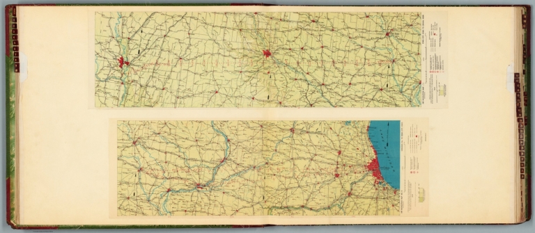
![جريدهء عدليه [Cerîde-i Adliye also Cerîde-i Adliyye]](https://www.davidrumsey.com/rumsey/Size2/RUMSEY~8~1/213/15819001.jpg)
![جريدهء عدليه [Cerîde-i Adliye also Cerîde-i Adliyye]](https://www.davidrumsey.com/rumsey/Size1/RUMSEY~8~1/213/15819002.jpg)