|
Author
Rand McNally and Company
Full Title
(Text Page) Maryland - Counties, Bays, Creeks, Islands, Mountains, Rivers, Towns, Etc.
List No
5028BE
Note
Geographical features keyed to map; populations of towns. List of electric rail lines.
Author
Rand McNally and Company
Full Title
Commercial Atlas of America. Rand McNally Standard Map of Maryland and Delaware. (with) Baltimore and Environs.
List No
5028.043
Note
List of railroads and principal cities keyed to map.
Author
Rand McNally and Company
Full Title
(Text Page) Maryland - Counties, Bays, Creeks, Islands, Mountains, Rivers, Towns, Etc. Maryland, Delaware and District of Columbia Electric Lines.
List No
5028BF
Note
Geographical features keyed to map; populations of towns. List of electric rail lines.
Author
Rand McNally and Company
Full Title
Commercial Atlas of America. Rand McNally Standard Map of Washington D.C.
List No
5028.044
Note
Shows railroads, street car lines, and key structures.
Author
Rand McNally and Company
Full Title
Commercial Atlas of America. Rand McNally Black and White Mileage Map, Maryland and Delaware.
List No
5028.045
Author
Rand McNally and Company
Full Title
(Text Page) Delaware - Counties, Bays, Cape, Creeks, Rivers, and Towns. District of Columbia - Towns. Maryland, Delaware and District of Columbia Electric Lines.
List No
5028BG
Note
Geographical features keyed to map; populations of towns. List of electric rail lines.
Author
Rand McNally and Company
Full Title
Commercial Atlas of America. Rand McNally Auto Trail Map. District Number 20. Indiana, Ohio, Virginia, North Carolina, South Carolina, Georgia.
List No
5028.046
Note
Shows Trail and Highway Markings with route numbers.
Author
Rand McNally and Company
Full Title
Commercial Atlas of America. Rand McNally 14 x 21 Inch Map of Baltimore.
List No
5028.047
Note
Shows key buildings, railroads, and electric lines.
Author
Rand McNally and Company
Full Title
(Text Page) Virginia - Counties, Creeks, Islands, Mountains, Rivers, and Towns.
List No
5028BH
Note
Geographical features keyed to map; populations of towns.
Author
Rand McNally and Company
Full Title
Commercial Atlas of America. Rand McNally Standard Map of Virginia.
List No
5028.048
Note
Shows tables of principal cities and railroads, keyed to map. Inset extension of main map. Relief shown by hachures.
Author
Rand McNally and Company
Full Title
(Text Page) Virginia - Counties, Creeks, Islands, Mountains, Rivers, and Towns.
List No
5028BI
Note
Geographical features keyed to map; populations of towns.
Author
Rand McNally and Company
Full Title
Commercial Atlas of America. Rand McNally Black and White Map of Virginia and West Virginia.
List No
5028.049
Note
Shows tables of principal cities keyed to map.
Author
Rand McNally and Company
Full Title
(Text Page) Virginia - Counties, Creeks, Islands, Mountains, Rivers, and Towns.
List No
5028BJ
Note
Geographical features keyed to map; populations of towns. Shows Virginia electric lines.
Author
Rand McNally and Company
Full Title
Commercial Atlas of America. Rand McNally Standard Map of West Virginia.
List No
5028.050
Note
Shows tables of principal cities and railroads, keyed to map. Inset extension of main map. Relief shown by hachures.
Author
Rand McNally and Company
Full Title
(Text Page) West Virginia - Counties, Creeks, Mountains, Rivers, and Towns.
List No
5028BK
Note
Geographical features keyed to map; populations of towns.
Author
Rand McNally and Company
Full Title
(Text Page) West Virginia - Counties, Creeks, Mountains, Rivers, and Towns.
List No
5028BL
Note
Geographical features keyed to map; populations of towns.
Author
Rand McNally and Company
Full Title
(Text Page) West Virginia - Counties, Creeks, Mountains, Rivers, and Towns. North Carolina - Counties, Creeks, Islands, Lakes, Rivers, and Towns.
List No
5028BM
Note
Geographical features keyed to map; populations of towns.
Author
Rand McNally and Company
Full Title
Commercial Atlas of America. Rand McNally Standard Map of North Carolina.
List No
5028.051
Note
Shows tables of principal cities and railroads, keyed to map. Inset extension of main map. Relief shown by hachures. Inset extension of main map.
Author
Rand McNally and Company
Full Title
(Text Page) North Carolina - Counties, Creeks, Islands, Lakes, Rivers, and Towns.
List No
5028BN
Note
Geographical features keyed to map; populations of towns.
Author
Rand McNally and Company
Full Title
(Text Page) North Carolina - Counties, Creeks, Islands, Lakes, Rivers, and Towns. North Carolina Electric Lines.
List No
5028BO
Note
Geographical features keyed to map; populations of towns.
Author
Rand McNally and Company
Full Title
Commercial Atlas of America. Rand McNally Black and White Mileage Map of North Carolina.
List No
5028.052
Note
Shows railroads and distances.
Author
Rand McNally and Company
Full Title
(Text Page) South Carolina - Counties, Creeks, Islands, Rivers, and Towns.
List No
5028BP
Note
Geographical features keyed to map; populations of towns.
Author
Rand McNally and Company
Full Title
Commercial Atlas of America. Rand McNally Standard Map of South Carolina.
List No
5028.053
Note
Includes tables of principal cities and railroads, keyed to map.
Author
Rand McNally and Company
Full Title
(Text Page) South Carolina - Counties, Creeks, Islands, Rivers, and Towns.
List No
5028BQ
Note
Geographical features keyed to map; populations of towns. Table of electric lines.
Author
Rand McNally and Company
Full Title
Commercial Atlas of America. Rand McNally Black and White Mileage Map of South Carolina.
List No
5028.054
Note
Shows railroads and distances.
Author
Rand McNally and Company
Full Title
(Text Page) Georgia - Counties, Creeks, Islands, Rivers, Sounds, and Towns.
List No
5028BR
Note
Geographical features keyed to map; populations of towns.
Author
Rand McNally and Company
Full Title
Commercial Atlas of America. Rand McNally Auto Trails Map. District No. 21. Florida, Georgia, Alabama, So. Tennessee, So. No. Carolina, Mississippi, So. Carolina, and S.E. Louisiana. Key to trail and highway numbers and markings.
List No
5028.055
Note
Shows roads and distances.
Author
Rand McNally and Company
Full Title
(Text Page) Georgia - Counties, Creeks, Islands, Rivers, Sounds, and Towns.
List No
5028BS
Note
Geographical features keyed to map; populations of towns.
Author
Rand McNally and Company
Full Title
Commercial Atlas of America. Rand McNally Standard Map of Georgia.
List No
5028.056
Note
Includes tables of principal cities and railroads, keyed to map.
Author
Rand McNally and Company
Full Title
(Text Page) Georgia - Counties, Creeks, Islands, Rivers, Sounds, and Towns.
List No
5028BT
Note
Geographical features keyed to map; populations of towns. Shows electric lines.
Author
Rand McNally and Company
Full Title
Commercial Atlas of America. Rand McNally Auto Trails Map. District No. 21. State of Florida. Key to trail and highway numbers and markings.
List No
5028.057
Note
Shows roads and distances.
Author
Rand McNally and Company
Full Title
Commercial Atlas of America. Rand McNally Black and White Mileage Map, Georgia.
List No
5028.058
Note
Shows roads and distances.
Author
Rand McNally and Company
Full Title
(Text Page) Florida - Counties, Creeks, Islands, Lakes, Rivers, and Towns.
List No
5028BU
Note
Geographical features keyed to map; populations of towns. Shows electric lines.
Author
Rand McNally and Company
Full Title
Commercial Atlas of America. Rand McNally Standard Map of Florida. (with) Southern Portion of Florida.
List No
5028.059
Note
Shows railroads and distances. Includes tables of principal cities and railroads, keyed to map. Inset is a continuation of main map.
Author
Rand McNally and Company
Full Title
(Text Page) Florida - Counties, Creeks, Islands, Lakes, Rivers, and Towns.
List No
5028BV
Note
Geographical features keyed to map; populations of towns. Shows electric lines.
Author
Rand McNally and Company
Full Title
Commercial Atlas of America. Rand McNally Black and White Mileage Map, Florida.
List No
5028.060
Note
Shows roads and distances. Inset of Florida Keys is a continuation of main map.
Author
Rand McNally and Company
Full Title
(Text Page) Alabama - Counties, Creeks, Islands, Lakes, Rivers, and Towns.
List No
5028BW
Note
Geographical features keyed to map; populations of towns. Shows electric lines.
Author
Rand McNally and Company
Full Title
(Text Page) Alabama - Counties, Creeks, Islands, Lakes, Rivers, and Towns.
List No
5028BX
Note
Geographical features keyed to map; populations of towns. Shows electric lines.
Author
Rand McNally and Company
Full Title
Commercial Atlas of America. Rand McNally Standard Map of Alabama. (with) Birmingham and Vicinity.
List No
5028.061
Note
Shows railroads and distances. Includes tables of principal cities and railroads, keyed to map. Inset at 1:190,000.
Author
Rand McNally and Company
Full Title
(Text Page) Alabama - Counties, Creeks, Islands, Lakes, Rivers, and Towns.
List No
5028BY
Note
Geographical features keyed to map; populations of towns. Shows electric lines.
Author
Rand McNally and Company
Full Title
Commercial Atlas of America. Rand McNally Black and White Mileage Map, Alabama.
List No
5028.062
Note
Shows roads and distances.
Author
Rand McNally and Company
Full Title
Commercial Atlas of America. Rand McNally Standard Map of Mississippi. (with) Birmingham and Vicinity.
List No
5028.063
Note
Shows railroads and distances. Includes tables of principal cities and railroads, keyed to map.
Author
Rand McNally and Company
Full Title
(Text Page) Mississippi - Counties, Creeks, Islands, Lakes, Rivers, and Towns.
List No
5028BZ
Note
Geographical features keyed to map; populations of towns. Shows electric lines.
Author
Rand McNally and Company
Full Title
Commercial Atlas of America. Rand McNally Black and White Mileage Map, Mississippi.
List No
5028.064
Note
Shows roads and distances.
Author
Rand McNally and Company
Full Title
(Text Page) Mississippi - Counties, Creeks, Islands, Lakes, Rivers, and Towns.
List No
5028CA
Note
Geographical features keyed to map; populations of towns. Shows electric lines.
Author
Rand McNally and Company
Full Title
(Text Page) Mississippi - Counties, Creeks, Islands, Lakes, Rivers, and Towns. Tennessee - Counties, Creeks, Mountains, Rivers, and Towns.
List No
5028CB
Note
Geographical features keyed to map; populations of towns. Shows electric lines.
Author
Rand McNally and Company
Full Title
Commercial Atlas of America. Rand McNally Standard Map of Tennessee.
List No
5028.065
Note
Shows railroads and distances. Includes tables of principal cities and railroads, keyed to map.
Author
Rand McNally and Company
Full Title
(Text Page) Tennessee - Counties, Creeks, Mountains, Rivers, and Towns.
List No
5028CC
Note
Geographical features keyed to map; populations of towns. Shows electric lines.
Author
Rand McNally and Company
Full Title
Commercial Atlas of America. Rand McNally Black and White Mileage Map, Tennessee.
List No
5028.066
Note
Shows roads and distances.
Author
Rand McNally and Company
Full Title
(Text Page) Tennessee - Counties, Creeks, Mountains, Rivers, and Towns.
List No
5028CD
Note
Geographical features keyed to map; populations of towns. Shows electric lines.
Author
Rand McNally and Company
Full Title
(Text Page) Tennessee - Counties, Creeks, Mountains, Rivers, and Towns. Kentucky - Counties, Creeks, Mountains, Rivers, and Towns.
List No
5028CE
Note
Geographical features keyed to map; populations of towns. Shows electric lines.
Author
Rand McNally and Company
Full Title
Commercial Atlas of America. Rand McNally Standard Map of Kentucky.
List No
5028.067
Note
Shows railroads and distances. Includes tables of principal cities and railroads, keyed to map.
Author
Rand McNally and Company
Full Title
(Text Page) Kentucky - Counties, Creeks, Mountains, Rivers, and Towns.
List No
5028CF
Note
Geographical features keyed to map; populations of towns. Shows electric lines.
Author
Rand McNally and Company
Full Title
(Text Page) Kentucky - Counties, Creeks, Mountains, Rivers, and Towns.
List No
5028CG
Note
Geographical features keyed to map; populations of towns. Shows electric lines.
Author
Rand McNally and Company
Full Title
(Text Page) Kentucky - Counties, Creeks, Mountains, Rivers, and Towns.
List No
5028CH
Note
Geographical features keyed to map; populations of towns. Shows electric lines.
Author
Rand McNally and Company
Full Title
Commercial Atlas of America. Rand McNally Black and White Mileage Map, Kentucky.
List No
5028.068
Note
Shows railroads and distances.
Author
Rand McNally and Company
Full Title
Commercial Atlas of America. Rand McNally AutoTrails Map, District Number 4, Eastern Ohio, Western Pennsylvania, S.E. Michigan, Southern Ontario, Western New York, Western Maryland, Northern West Virginia.
List No
5028.069
Note
Shows roads and distances. Shows table of highway names, numbers, and markings.
Author
Rand McNally and Company
Full Title
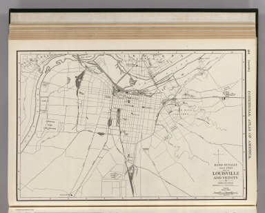
Commercial Atlas of America. Rand McNally 14 x 21 Inch Map of Louisville and Vicinity.
List No
5028.070
Note
Shows roads and railroads.
Author
Rand McNally and Company
Full Title
(Text Page) Ohio - Counties, Creeks, Islands, Rivers, and Towns.
List No
5028CI
Note
Geographical features keyed to map; populations of towns. Shows electric lines.
Author
Rand McNally and Company
Full Title
Commercial Atlas of America. Rand McNally Standard Map of Ohio. (Northern Section)
List No
5028.071
Note
Shows railroads and distances. Includes tables of principal cities and railroads, keyed to map.
Author
Rand McNally and Company
Full Title
(Text Page) Ohio - Counties, Creeks, Islands, Rivers, and Towns.
List No
5028CJ
Note
Geographical features keyed to map; populations of towns. Shows electric lines.
Author
Rand McNally and Company
Full Title
Commercial Atlas of America. Rand McNally Standard Map of Ohio. (Southern Section)
List No
5028.072
Note
Shows railroads and distances. Includes tables of principal cities and railroads, keyed to map.
Author
Rand McNally and Company
Full Title
(Text Page) Ohio - Counties, Creeks, Islands, Rivers, and Towns.
List No
5028CK
Note
Geographical features keyed to map; populations of towns. Shows electric lines.
Author
Rand McNally and Company
Full Title
Commercial Atlas of America. Rand McNally Black and White Mileage Map, Ohio.
List No
5028.073
Note
Shows railroads and distances.
Author
Rand McNally and Company
Full Title
(Text Page) Ohio - Counties, Creeks, Islands, Rivers, and Towns.
List No
5028CL
Note
Geographical features keyed to map; populations of towns. Shows electric lines.
Author
Rand McNally and Company
Full Title
Commercial Atlas of America. Rand McNally 14 x 21 Inch Map of Cleveland and Vicinity. Rand McNally 14 x 21 Inch Map of Cincinnati and Vicinity.
List No
5028.074
Note
Shows railroads, main roads, and key locations. Cleveland map at scale 1:35,000; Cincinnati map at scale 1:33,000.
Author
Rand McNally and Company
Full Title
Commercial Atlas of America. Rand McNally 14 x 21 Inch Map of Toledo and Vicinity.
List No
5028.075
Note
Shows railroads, main roads, and key locations.
Author
Rand McNally and Company
Full Title
(Text Page) Michigan - Counties, Creeks, Islands, Lakes, Rivers, and Towns.
List No
5028CM
Note
Geographical features keyed to map; populations of towns. Shows electric lines.
Author
Rand McNally and Company
Full Title
Commercial Atlas of America. Rand McNally Standard Map of Michigan, Southern Peninsula.
List No
5028.076
Note
Shows railroads and distances. Includes tables of principal cities and railroads, keyed to map.
Author
Rand McNally and Company
Full Title
(Text Page) Michigan - Counties, Creeks, Islands, Lakes, Rivers, and Towns.
List No
5028CN
Note
Geographical features keyed to map; populations of towns. Shows electric lines.
Author
Rand McNally and Company
Full Title
Commercial Atlas of America. Rand McNally Standard Map of Michigan, Northern Peninsula.
List No
5028.077
Note
Shows railroads and distances. Includes tables of principal cities and railroads, keyed to map.
Author
Rand McNally and Company
Full Title
(Text Page) Michigan - Counties, Creeks, Islands, Lakes, Rivers, and Towns.
List No
5028CO
Note
Geographical features keyed to map; populations of towns. Shows electric lines.
Author
Rand McNally and Company
Full Title
Commercial Atlas of America. Rand McNally Black and White Mileage Map, Michigan.
List No
5028.078
Note
Shows railroads and distances.
Author
Rand McNally and Company
Full Title
Commercial Atlas of America. Rand McNally 14 x 21 Inch Map of Detroit and Vicinity.
List No
5028.079
Note
Shows railroads, main roads, and key locations.
Author
Rand McNally and Company
Full Title
Commercial Atlas of America. Rand McNally 14 x 21 Inch Map of Indianapolis and Vicinity.
List No
5028.080
Note
Shows railroads, main roads, and key locations.
Author
Rand McNally and Company
Full Title
Commercial Atlas of America. Rand McNally AutoTrails Map, District Number 3, Southern Peninsula of Michigan, Northern Indiana, Northwestern Ohio. (with) Map of Eastern Half, Northern Peninsula, Michigan. (with) Chicago.
List No
5028.081
Note
Shows roads and distances. Shows table of highway names, numbers, and markings.
Author
Rand McNally and Company
Full Title
(Text Page) Indiana - Counties, Creeks, Lakes, Rivers, and Towns.
List No
5028CP
Note
Geographical features keyed to map; populations of towns. Shows electric lines.
Author
Rand McNally and Company
Full Title
Commercial Atlas of America. Rand McNally Standard Map of Indiana.
List No
5028.082
Note
Shows railroads and distances. Includes tables of principal cities and railroads, keyed to map.
Author
Rand McNally and Company
Full Title
(Text Page) Indiana - Counties, Creeks, Lakes, Rivers, and Towns.
List No
5028CQ
Note
Geographical features keyed to map; populations of towns. Shows electric lines.
Author
Rand McNally and Company
Full Title
Commercial Atlas of America. Rand McNally AutoTrails Map, District Number 2, Eastern Illinois, Southern Mich., Indiana, Western Ohio, Northern Ky.
List No
5028.083
Note
Shows roads and distances. Shows table of highway names, numbers, and markings.
Author
Rand McNally and Company
Full Title
(Text Page) Indiana - Counties, Creeks, Lakes, Rivers, and Towns.
List No
5028CR
Note
Geographical features keyed to map; populations of towns. Shows electric lines.
Author
Rand McNally and Company
Full Title
Commercial Atlas of America. Rand McNally Black and White Mileage Map, Indiana.
List No
5028.084
Note
Shows railroads and distances.
Author
Rand McNally and Company
Full Title
Commercial Atlas of America. Rand McNally Standard Map of Illinois.
List No
5028.085
Note
Shows railroads and distances. Includes tables of principal cities and railroads, keyed to map.
Author
Rand McNally and Company
Full Title
(Text Page) Illinois - Counties, Creeks, Lakes, Rivers, and Towns.
List No
5028CS
Note
Geographical features keyed to map; populations of towns. Shows electric lines.
Author
Rand McNally and Company
Full Title
Commercial Atlas of America. Rand McNally Standard Railway Terminal Map of Chicago.
List No
5028.086
Note
Shows railroads keyed to map.
Author
Rand McNally and Company
Full Title
Commercial Atlas of America. Rand McNally Black and White Mileage Map, Illinois. (with) St. Louis. (with) Chicago.
List No
5028.087
Note
Shows railroads and distances.
Author
Rand McNally and Company
Full Title
(Text Page) Illinois - Counties, Creeks, Lakes, Rivers, and Towns.
List No
5028CT
Note
Geographical features keyed to map; populations of towns. Shows electric lines.
Author
Rand McNally and Company
Full Title
Commercial Atlas of America. Rand McNally AutoTrails Map, District Number 1. Illinois, Western Indiana, S.E. Iowa, N.E. Missouri.
List No
5028.088
Note
Shows roads and distances. Shows table of highway names, numbers, and markings.
Author
Rand McNally and Company
Full Title
(Text Page) Illinois - Counties, Creeks, Lakes, Rivers, and Towns.
List No
5028CU
Note
Geographical features keyed to map; populations of towns. Shows electric lines.
Author
Rand McNally and Company
Full Title
Commercial Atlas of America. Rand McNally Standard Map of Chicago District.
List No
5028.089
Note
Shows railroads and distances. Includes tables of principal cities and railroads, keyed to map.
Author
Rand McNally and Company
Full Title
(Text Page) Illinois - Counties, Creeks, Lakes, Rivers, and Towns. Wisconsin - Counties, Creeks, Islands, Lakes, Rivers, Towns, Etc.
List No
5028CV
Note
Geographical features keyed to map; populations of towns. Shows electric lines.
Author
Rand McNally and Company
Full Title
Commercial Atlas of America. Rand McNally Standard Map of Wisconsin.
List No
5028.090
Note
Shows railroads and distances. Includes tables of principal cities and railroads, keyed to map.
Author
Rand McNally and Company
Full Title
(Text Page) Illinois - Wisconsin - Counties, Creeks, Islands, Lakes, Rivers, Towns, Etc.
List No
5028CW
Note
Geographical features keyed to map; populations of towns. Shows electric lines.
Author
Rand McNally and Company
Full Title
Commercial Atlas of America. Rand McNally AutoTrails Map, District Number 8, Wisconsin, Northern Ill., Northern Mich.
List No
5028.091
Note
Shows roads and distances. Shows table of highway names, numbers, and markings.
Author
Rand McNally and Company
Full Title
Commercial Atlas of America. Rand McNally Black and White Mileage Map, Wisconsin. (with) Milwaukee. Rand McNally 14 x 21 Inch Map of Milwaukee and Vicinity.
List No
5028.092
Note
Shows railroads and distances. Map of Milwaukee and Vicinity at scale 1:29,000.
Author
Rand McNally and Company
Full Title
(Text Page) Wisconsin - Counties, Creeks, Islands, Lakes, Rivers, Towns, Etc. Minnesota - Counties, Creeks, Indian Reservations, Lakes, Rivers, and Towns.
List No
5028CX
Note
Geographical features keyed to map; populations of towns. Shows electric lines.
Author
Rand McNally and Company
Full Title
Commercial Atlas of America. Rand McNally Standard Map of Minnesota. (with) St. Paul - Minneapolis and Vicinity.
List No
5028.093
Note
Shows railroads and distances. Includes tables of principal cities and railroads, keyed to map.
Author
Rand McNally and Company
Full Title
(Text Page) Minnesota - Counties, Creeks, Indian Reservations, Lakes, Rivers, and Towns.
List No
5028CY
Note
Geographical features keyed to map; populations of towns. Shows electric lines.
Author
Rand McNally and Company
Full Title
Commercial Atlas of America. Rand McNally Black and White Mileage Map, Minnesota.
List No
5028.094
Note
Shows railroads and distances.
Author
Rand McNally and Company
Full Title
Commercial Atlas of America. Rand McNally AutoTrails Map, District Number 9, Minnesota, W. Wisconsin.
List No
5028.095
Note
Shows roads and distances. Shows table of highway names, numbers, and markings.
|