|
Author
Shipov, Nikolai
Full Title
Стенная карта Европейской России с изображением народов и их промыслов (Wall Map European Russia With Images of Peoples and Their Crafts. 35d Edition. Corrected and Expanded.
List No
15969.000
Author
Scott and Child
Full Title
Indexed Map of the City and County of San Francisco Showing Official Grades and Subdivisions. Compiled from Latest Public and Private Data by Scott and Child Map Publishers Anglo Building 18th & Mission St's S.F. Phone Market 3638.
List No
15429.000
Author
Bacon, G.W.
Full Title
(Covers to) Bacon's County Map and Guide Essex With Parts Of Adjoining Counties For Cyclists & Tourists On Cloth, In Case 1s. Net. London: G. W. Bacon & Co., Ltd., 127, Strand. With Route Guide. (with) Bacon's Map Of Essex Revised According To The Latest Ordnance Survey.
List No
5416.001
Note
Date estimated.
Author
Bacon, G.W.
Full Title
Bacon's County Map and Guide Essex With Parts Of Adjoining Counties For Cyclists & Tourists On Cloth, In Case 1s. Net. London: G. W. Bacon & Co., Ltd., 127, Strand. With Route Guide. (with) Bacon's Map Of Essex Revised According To The Latest Ordnance Survey.
List No
5416.002
Note
Date estimated.
Author
Bacon, G.W.
Full Title
(Covers to) Bacon's County Map and Guide Kent With Parts Of Adjoining Counties On Cloth in Case, 1s. Net For Cyclists And Tourists G. W. Bacon & Co., Ltd., 127, Strand, London. With Route Guide Showing Danger Hills. (with) Bacon's Map of Kent.
List No
5417.001
Note
Date estimated.
Author
Bacon, G.W.
Full Title
Bacon's County Map and Guide Kent With Parts Of Adjoining Counties On Cloth in Case, 1s. Net For Cyclists And Tourists G. W. Bacon & Co., Ltd., 127, Strand, London. With Route Guide Showing Danger Hills. (with) Bacon's Map of Kent.
List No
5417.002
Note
Date estimated.
Author
Lane, John J. (John Jenness), 1860-
Full Title
(Covers to) Trolley Wayfinder : Birds eye view of trolley routes in New England. Published by the New England Street Railway Club. John J. Lane, Editor of "Trolley Wayfinder" and "Trolley Wayfinder Birds Eye View of Tolley Routes". 12 Pearl St., Boston, Mass. 1908.
List No
14456.001
Note
Covers to Trolley Wayfinder : Birds eye view of trolley routes in New England, folded. Front cover includes cover title and imprint.
Author
Lane, John J. (John Jenness), 1860-
Full Title
Trolley Wayfinder : Birds eye view of trolley routes in New England. Published by New England Street Railway Club. 12 Pearl St., Boston, Mass. 1908.
List No
14456.002
Note
Pocket railway map of New England. Front cover includes cover title and imprint. Map shows railways, roads, buildings, topography, vegetation, bodies of water and drainage. With seven inset maps: [Boston and vicinity] -- Portsmouth and Lewiston -- Springfield to Turners Falls -- Worcester to Springfield -- Springfield to New York City -- Pittsfield and vicinity -- Rochester to Nashua -- A triangle route. Map is 52 x 36 cm, on fold-out sheet 53 x 37 cm. With advertisement on verso of front cover, which faces map.
Author
[Behaim, Martin, 1459-1507, Ravenstein, Ernest George, 1834-1913]
Full Title
(Portrait) Martin Behaim.
List No
12237.004
Author
Boyaciyan Agop Matbaasında
Full Title
(Covers to) جغرافیای طبیعی علمنه اساس مختصر = Geography-i Natural Science Esas-i Muhtasar. استانبولده بویاجیان آغوب مطبعه سنده طبع اولنمشدر ۱۹۰۸ = İstanbulda : Boyaciyan Agop Matbaasında, 1908.
List No
13685.001
Author
Boyaciyan Agop Matbaasında
Full Title
(Title Page to) جغرافیای طبیعی علمنه اساس مختصر = Geography-i Natural Science Esas-i Muhtasar. استانبولده بویاجیان آغوب مطبعه سنده طبع اولنمشدر ۱۹۰۸ = İstanbulda : Boyaciyan Agop Matbaasında, 1908.
List No
13685.002
Author
Boyaciyan Agop Matbaasında
Full Title
(Contents to) جغرافیای طبیعی علمنه اساس مختصر = Geography-i Natural Science Esas-i Muhtasar. استانبولده بویاجیان آغوب مطبعه سنده طبع اولنمشدر ۱۹۰۸ = İstanbulda : Boyaciyan Agop Matbaasında, 1908.
List No
13685.003
Author
Boyaciyan Agop Matbaasında
Full Title
(World map, mountains, volcanoes). Manissadjian & Co., Basle, Switzerland.
List No
13685.018
Note
Color map of the world principal mountains. Showing continents and oceans. Title provided by cataloger. Relief shown by hachures. Prime meridian: Greenwich.
Author
Boyaciyan Agop Matbaasında
Full Title
(World map of volcanoes). Manissadjian & Co., Basle, Switzerland.
List No
13685.021
Note
Color map of the world principal mountains and volcanoes. Title provided by cataloger. Relief shown by hachures. Prime meridian: Greenwich.
Author
Boyaciyan Agop Matbaasında
Full Title
(World rivers). Manissadjian & Co., Basle, Switzerland. جغرافیای طبیعی = Physial geography.
List No
13685.028
Note
Color base map of the world rivers, showing major rivers of the world. Prime meridian: Greenwich. Title provided by cataloger.
Author
Boyaciyan Agop Matbaasında
Full Title
اقیانوس اقنتیلرينئ مبين خريطة. Manissadjian & Co., Basle, Switzerland. جغرافیای طبیعی = Physial geography.
List No
13685.033
Note
Color map of the world oceans. Showing mountains and rivers. Relief shown by hachures. Prime meridian: Greenwich. Title provided by cataloger.
Author
Boyaciyan Agop Matbaasında
Full Title
(Temperature map of the world). Manissadjian & Co., Basle, Switzerland. جغرافیای طبیعی = Physial geography.
List No
13685.038
Note
Regional map of the world temperature. Depicting color contour isotherms, or lines of equal temperature in degrees. Relief shown by hachures. Prime meridian: Greenwich. Title provided by cataloger.
Author
Boyaciyan Agop Matbaasında
Full Title
(Climate map of the world). Manissadjian & Co., Basle, Switzerland. جغرافیای طبیعی = Physial geography.
List No
13685.042
Note
Color climate map of the world. illustrating the principal features of meteorology in different parts of the world. Regions have been classified according to their main climate condition, including currents, precipitation and temperature. Prime meridian: Greenwich. Title provided by cataloger.
Author
Boyaciyan Agop Matbaasında
Full Title
بقعه نبات خريطه = Vegetation map. Manissadjian & Co., Basle, Switzerland. جغرافیای طبیعی = Physial geography.
List No
13685.054
Note
Map of the world, illustrating the cultivation and distribution areas of the principal plants. Prime meridian: Greenwich.
Author
Boyaciyan Agop Matbaasında
Full Title
ماءوا خریطه سی = Water map of the world. Manissadjian & Co., Basle, Switzerland. جغرافیای طبیعی = Physial geography.
List No
13685.060
Note
Color map of the world water bodies, including lakes, seas, oceans, and large rivers. Prime meridian: Greenwich.
Author
Boyaciyan Agop Matbaasında
Full Title
سلاسل بشر خریطه سی = Map of the human race. Manissadjian & Co., Basle, Switzerland. جغرافیای طبیعی = Physial geography.
List No
13685.064
Note
Color map of the world, with color coded reference to the divisions of human race and ethnicity. Prime meridian: Greenwich.
Author
[Suomen Maantieteellinen Seura, Tilgmann, Ferdinand, 1832-1911]
Full Title
Ulkommaankauppa. = Commerce extérieur. = Utrikes handel. : Tuonti tavarain kulutuksen ja valmistusasteen mukaan milj. markoissa. = Importations réparties d'après leur emploi et leur degré de fabrication, en mill. de marcs. = Import efter varornas ändamål och bearbetningsgrad i milj. mark. -- Vienti elinkeinojen mukaan milj. markoissa. = Exportations réparties d'après l'industrie productrice, en mill. de marcs. = Export efter industrigrenar i milj. mark. -- 1908. Tuonti ja vienti jaettuna tullitoimistoja kohti = Importations et exportations par bureaux de douane = Import och export fördelad å tullanstalterna -- Sahatuotteiden vienti : Vientisatamain ja määrämaiden mukaan. = Exportation des sciages : Par ports et par pays de destination. = Export af sågtillverkningar : Efter exporthamnar och destinationsländer. Aktiebolaget F. Tilgmann, Helsingfors 1910.
List No
14367.093
Note
Four economic charts and two maps of Finland. Charts and maps feature foreign trade, including imports divided according to use and degree of manufacture (in millions of Finnish markka), exports broken down by producing industry (in millions of Finnish markka), imports and exports by customs offices, and exports of sawn timber, from 1865 to 1908. Maps also show political boundaries, cities, drainage, coastlines and islands. Charts include explanatory notes and first map includes a legend. Colored lithograph. Together, charts and maps are 39 x 57 cm, on double sheet 43 x 60 cm. Text presented in parallel Finnish, French and Swedish. Preceded by section title page for charts and maps.
Author
Hyde, E. Belcher
Full Title
Westchester County, State Of New York, Also A Portion Of The State Of Connecticut Embracing The Towns Of Greenwich, Stamford, Darien, New Canaan, Ridgefield. Published By E. Belcher Hyde, No. 5 Beekman Street, Manhattan, And No. 97 Liberty Street, Brooklyn. 1908. Entered ... 1908 by E. Belcher Hyde. C.W.H.
List No
3231.000
Author
[(Montana) Railroad Commission, Rand McNally and Company.]
Full Title
(Covers to) Railroad Commission Map Of Montana 1908. Commissioners: B.T. Stanton, Nathan Godfrey, E.A. Morley, H.K. Howry, Secretary. Rand, McNally & Co. Engravers, Chicago. Copyright, 1908, by Rand McNally & Co.
List No
4343.001
Author
[(Montana) Railroad Commission, Rand McNally and Company.]
Full Title
Railroad Commission Map Of Montana 1908. Commissioners: B.T. Stanton, Nathan Godfrey, E.A. Morley, H.K. Howry, Secretary. Rand, McNally & Co. Engravers, Chicago. Copyright, 1908, by Rand McNally & Co.
List No
4343.002
Author
[Mehmed Reşid Efendi, Haji Mehmet Nasrullah]
Full Title
مكمل اسيا خريطه سى [Map of Entire Asia]
List No
15103.000
Author
مطبعه عثمانيه [Matbaa Osmania]
Full Title
مفصل اوقيانوسيه حريطه سى [Detailed Map of Oceania]
List No
15007.000
Author
Esref, Mehmed, 1847-1912
Full Title
Istanbul & Dersaadet civâri Bogaziçi haritasi [Istanbul - The Bosphorus map]
List No
10809.001
Author
Esref, Mehmed, 1847-1912
Full Title
Istanbul & Dersaadet civâri Bogaziçi haritasi [Istanbul - The Bosphorus map]
List No
10809.002
Author
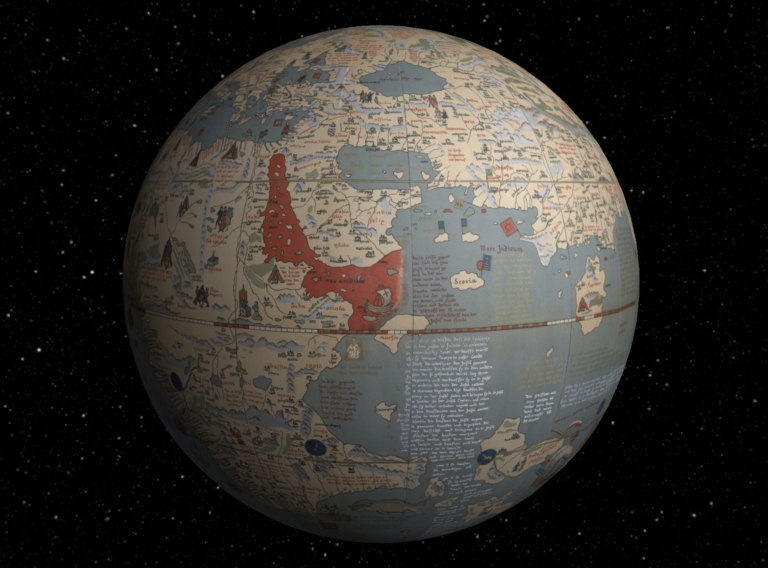
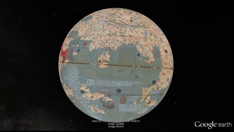
[Behaim, Martin, 1459-1507, Ravenstein, Ernest George, 1834-1913]
Full Title
Interactive Globe: Martin Behaim's Erdapfel, 1492, in Google Earth. (Facsimile of Behaim's Globe).
List No
12237.027
Note
Interactive Globe of georeferenced globe gores in Google Earth. 12 Gores and 2 Polar Calottes, Date of original.
Author
[Papachrysanthou, V., Georgiades, S.]
Full Title
(Geogiades plan of Athens and its ancient and modern quarters. V. Papachrysanthou). 1908.
List No
13413.000
Note
(Plan of Athens and its ancient and modern quarters. V. Papachrysanthou). 1908.
Author
Klein, Rudolf
Full Title
(Covers to) Panorama von Graz : Gezeichnet von Rudolf Klein 1908. Steirischer Gebirgsverein, Graz.
List No
13332.001
Author
Klein, Rudolf
Full Title
(4 Views) Panorama von Graz : Gezeichnet von Rudolf Klein 1908. Steirischer Gebirgsverein, Graz.
List No
13332.002
Note
4 views of Graz inside the covers.
Author
Klein, Rudolf
Full Title
Panorama von Graz : Gezeichnet von Rudolf Klein 1908. Steirischer Gebirgsverein, Graz. Lith. Art. Anst. Ernest Matthey Erben, Graz.
List No
13332.003
Author
Flotte de Roquevaire, Rene de
Full Title
Maroc : carte dressee et dessinee par R. de Flotte de Roquevaire 1908. Grave et imprime par Erhard Fres ... Henry Barrere, Editeur.
List No
13217.000
Note
Highly detailed map with printed color, with 17 insets on sheet 97x130, dissected and backed with linen folded to 25x16. Shows capitals, major cities, towns, landmarks, roads, railroads, rivers and mountains. Relief shown by shadings and hachures. Includes legend and index.
Author
[Silk, D. Wenaslin, Cavalcanti, Manoel Paulino, Sociedade Nacional de Agricultura (Brazil). Seccao de Geographia Agricola]
Full Title
Sociedade Nacional de Agricultura. Seccao Geographia Agricola : Grande premio na Expisicao Nacional de 1908. (Gradn prix a l'Exposicao Nacional 1908). Ensaio de mappa geologico do Brazil (Etude de carte geologique du Bresil). Visto, D. Wenaslin Silk. Organisado por M. Paulino Cavalcanti. Seccao Cartographica do Estabelecimento Graphico - Weiszflog, Irmaos - S. Paulo. (to accompany: Atlas do Brazil).
List No
11947.003
Note
Geological map of Brazil. Shows administrative divisions, rivers, forests and mountains. Relief shown by hachures. Includes legend.
Author
[Silk, D. Wenaslin, Cavalcanti, Manoel Paulino, Sociedade Nacional de Agricultura (Brazil). Seccao de Geographia Agricola]
Full Title
Sociedade Nacional de Agricultura. Seccao Geographia Agricola : Grande premio na Expisicao Nacional de 1908. (Gradn prix a l'Exposicao Nacional 1908). Ensaio de mappa agrologico do Brazil (Etude de carte agrologique du Bresil). Visto, D. Wenaslin Silk. Organisado por M. Paulino Cavalcanti. Seccao Cartographica do Estabelecimento Graphico - Weiszflog, Irmaos - S. Paulo. (to accompany: Atlas do Brazil).
List No
11947.004
Note
Agrological map of Brazil. Shows types of soil, administrative divisions, major cities, rivers, etc. Relief shown by hachures. Includes legend.
Author
[Silk, D. Wenaslin, Cavalcanti, Manoel Paulino, Sociedade Nacional de Agricultura (Brazil). Seccao de Geographia Agricola]
Full Title
Sociedade Nacional de Agricultura. Seccao Geographia Agricola : Grande premio na Expisicao Nacional de 1908. (Gradn prix a l'Exposicao Nacional 1908). Mappa demographico do Brazil (Carte demographique du Bresil). Visto, D. Wenaslin Silk. Organisado por M. Paulino Cavalcanti. Seccao Cartographica do Estabelecimento Graphico - Weiszflog, Irmaos - S. Paulo. (to accompany: Atlas do Brazil). (inset) America d Sul. Diagramma da populacao absouluta.
List No
11947.007
Note
Demographic map of Brazil, with diagram of the population of South America. Shows administrative divisions, major cities, rivers, forests and mountains. Relief shown by hachures. Includes legend.
Author
[Johnson Riddle & Company Ltd., London Underground Railways, London United Tramways Company Limited]
Full Title
London underground railways. Johnson Riddle & Co. Ltd. London. SE. (cover title) Underground : district, Bakerloo, Piccadilly and Hampstead railways. London United Tramways ...
List No
11613.002
Note
1st map to show the railway system, on sheet 22x27, folded into self wrapped cover, 11x7. Showing the Underground routes, some tram lines and other railways and the stations. Includes reference. On verso: notes on ticketing and schedule, list of station name leading to famous streets buildings. Includes text, and advertisements. Date estimated.
Author
[Behaim, Martin, 1459-1507, Ravenstein, Ernest George, 1834-1913]
Full Title
(Composite of) Globe Gores 1 - 4. Martin Behaim's Erdapfel, 1492. (Facsimile of Behaim's Globe).
List No
12237.020
Note
Composite of four sheets of globe gores joined. 12 Gores and 2 Polar Calottes, Date of original.
Author
[Behaim, Martin, 1459-1507, Ravenstein, Ernest George, 1834-1913]
Full Title
Composite: Robinson Projection. Martin Behaim's Erdapfel, 1492. (Facsimile of Behaim's Globe).
List No
12237.022
Note
Georeferenced globe gores reprojected to Robinson Projection. 12 Gores and 2 Polar Calottes, Date of original.
Author
[Behaim, Martin, 1459-1507, Ravenstein, Ernest George, 1834-1913]
Full Title
Composite: Times Projection. Martin Behaim's Erdapfel, 1492. (Facsimile of Behaim's Globe).
List No
12237.023
Note
Georeferenced globe gores reprojected to Times Projection. 12 Gores and 2 Polar Calottes, Date of original.
Author
[Behaim, Martin, 1459-1507, Ravenstein, Ernest George, 1834-1913]
Full Title
Video: Martin Behaim's Erdapfel, 1492, in Google Earth. (Facsimile of Behaim's Globe).
List No
12237.026
Note
Video of georeferenced globe gores in Google Earth. 12 Gores and 2 Polar Calottes, Date of original.
Author
Klemm, Josef
Full Title
New York. Ad. Lehmann's geogr. Charakterbilder. Verlag F. E. Wachsmutg, Leipzig.
List No
10050.001
Note
Date estimated based on presence of Singer Building of 1908 and absence of MetLife Tower of 1909 (thanks to Piotr Tarczynski for pointing this out to us). Birds-eye view of Manhattan and greater New York. From askArt: "Josef Ferdinand Klemm (Austrian, 1868-1916) was a noted painter, lithographer, designer and image restorer. He is primarily known for his finely detailed designs of cultural and historical mural study-decorations for schools that included landscapes, cityscapes, medieval cities, the Acropolis (Greece), various architectural renderings, memorial and national monuments, interior scenes, historical and cultural human genre/civil activities, as well as educational/industrial cut-away diagrams/wall-charts, geographical scenes, etc. Josef Klemm was born December 25, 1868 in Vienna, Austria to the Austrian bookseller and publisher Joseph Klemm (Austrian, b. Apr. 4, 1821-d. Feb. 27, 1882) and Johanna (née Fessl) Klemm." This copy came from a school in Helsinki, Finland.
Author
Klemm, Josef
Full Title
(Covers to) New York. Ad. Lehmann's geogr. Charakterbilder. Verlag F. E. Wachsmutg, Leipzig.
List No
10050.002
Note
Label of the Helsinki school district where the map was used? Date estimated based on presence of Singer Building of 1908 and absence of MetLife Tower of 1909 (thanks to Piotr Tarczynski for pointing this out to us). Birds-eye view of Manhattan and greater New York. From askArt: "Josef Ferdinand Klemm (Austrian, 1868-1916) was a noted painter, lithographer, designer and image restorer. He is primarily known for his finely detailed designs of cultural and historical mural study-decorations for schools that included landscapes, cityscapes, medieval cities, the Acropolis (Greece), various architectural renderings, memorial and national monuments, interior scenes, historical and cultural human genre/civil activities, as well as educational/industrial cut-away diagrams/wall-charts, geographical scenes, etc. Josef Klemm was born December 25, 1868 in Vienna, Austria to the Austrian bookseller and publisher Joseph Klemm (Austrian, b. Apr. 4, 1821-d. Feb. 27, 1882) and Johanna (née Fessl) Klemm." This copy came from a school in Helsinki, Finland.
Author
[Ministry of Finance, Egypt, Egypt. Wizarat al-Maliyah, Egypt. Maslahat al-Misahah]
Full Title
Sheet 165 Dabod
List No
10285.171
Author
[Ministry of Finance, Egypt, Egypt. Wizarat al-Maliyah, Egypt. Maslahat al-Misahah]
Full Title
Sheet 170 El Allaqi
List No
10285.176
Author
Criado, M. Alonso
Full Title
(Covers to) Mapa de la Republica del Paraguay. 2a. Edicion. Dirigido por M. Alonso Criado. Talleres Graficos A. Barreiro y Ramos. - Bme. Mitre, 61. Montevideo. (Cover title) La Republica del Paraguay. Por Matias Alonso Criado. Seconda edicion. Montevideo ... 1908. (insets) Plano de Asuncion y suburbios. (with) Croquis del Rio de La Plata: via fluvial y ferrocarriles al Paraguay. (with) El Paraguay en America.
List No
11470.001
Note
2nd. edition color map of Paraguay 74x106, on sheet 114x78 folded into covers 40.5x29, with 9 pages of descriptive text on verso. Pages 8-9 with partial text. By Matias Alonso Criado. Relief shown by hachures. Shows political boundaries, cities and towns, rivers, mountains and forests. Includes 3 insets, showing location map; detail plan of Ascuncion; la Plata River, Rio River and railways. Matias Alonso Criado (1852-1922) served as Consul General of Paraguay in Spain. He is also listed as the author of La republique du Paraguay, which included a smaller map of Paraguay.
Author
Criado, M. Alonso
Full Title
(Text page to) Mapa de la Republica del Paraguay. 2a. Edicion. Dirigido por M. Alonso Criado. Talleres Graficos A. Barreiro y Ramos. - Bme. Mitre, 61. Montevideo. (Cover title) La Republica del Paraguay. Por Matias Alonso Criado. Seconda edicion. Montevideo ... 1908. (insets) Plano de Asuncion y suburbios. (with) Croquis del Rio de La Plata: via fluvial y ferrocarriles al Paraguay. (with) El Paraguay en America.
List No
11470.002
Note
2nd. edition color map of Paraguay 74x106, on sheet 114x78 folded into covers 40.5x29, with 9 pages of descriptive text on verso. Pages 8-9 with partial text. By Matias Alonso Criado. Relief shown by hachures. Shows political boundaries, cities and towns, rivers, mountains and forests. Includes 3 insets, showing location map; detail plan of Ascuncion; la Plata River, Rio River and railways. Matias Alonso Criado (1852-1922) served as Consul General of Paraguay in Spain. He is also listed as the author of La republique du Paraguay, which included a smaller map of Paraguay.
Author
Criado, M. Alonso
Full Title
(Text page to) Mapa de la Republica del Paraguay. 2a. Edicion. Dirigido por M. Alonso Criado. Talleres Graficos A. Barreiro y Ramos. - Bme. Mitre, 61. Montevideo. (Cover title) La Republica del Paraguay. Por Matias Alonso Criado. Seconda edicion. Montevideo ... 1908. (insets) Plano de Asuncion y suburbios. (with) Croquis del Rio de La Plata: via fluvial y ferrocarriles al Paraguay. (with) El Paraguay en America.
List No
11470.003
Note
2nd. edition color map of Paraguay 74x106, on sheet 114x78 folded into covers 40.5x29, with 9 pages of descriptive text on verso. Pages 8-9 with partial text. By Matias Alonso Criado. Relief shown by hachures. Shows political boundaries, cities and towns, rivers, mountains and forests. Includes 3 insets, showing location map; detail plan of Ascuncion; la Plata River, Rio River and railways. Matias Alonso Criado (1852-1922) served as Consul General of Paraguay in Spain. He is also listed as the author of La republique du Paraguay, which included a smaller map of Paraguay.
|


![مكمل اسيا خريطه سى [Map of Entire Asia]](https://www.davidrumsey.com/rumsey/Size1/RUMSEY~8~1/199/15103000.jpg)
![مفصل اوقيانوسيه حريطه سى [Detailed Map of Oceania]](https://www.davidrumsey.com/rumsey/Size1/RUMSEY~8~1/195/1500700.jpg)
![Covers: Istanbul & Dersaadet civâri Bogaziçi haritasi [Istanbul - The Bosphorus map]](https://www.davidrumsey.com/rumsey/Size1/RUMSEY~8~1/190/10809001.jpg)
![Istanbul & Dersaadet civâri Bogaziçi haritasi [Istanbul - The Bosphorus map]](https://www.davidrumsey.com/rumsey/Size0/RUMSEY~8~1/190/10809002.jpg)