|
REFINE
Browse All : Images from 1896 and 1909
1-2 of 2
Author
[Commercial Club of Chicago. Civic Committee, Burnham, Daniel Hudson, 1846-1912, Bennett, Edward H. (Edward Herbert), 1874-1954, Moore, Charles, Lathrop, Paul]
Full Title
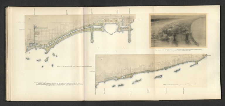
L. Chicago : Park development proposed for the lake shore from Jackson Park to Wilmette : Diagram A. Lake shore from Chicago Avenue on the north to Jackson Park on the south - Diagram B. Lake shore from Chicago Avenue on the south to Jackson Park on the north -- L(a). Chicago : View of the proposed park on the south shore, looking northwest towards the city / From the drawing of D. H. Burnham and Paul Lathrop, 1896.
List No
14346.048
Note
Two maps and one view of Chicago within fourth chapter to Plan of Chicago. Maps show roads, topography, parks, drainage, shoreline and harbor. Relief shown pictorially. With descriptive text: This park, enclosing lagoons for boating, would be a continuous playground for the people ... Colored lithograph. Together, maps and view are 25 x 60 cm, on fold-out sheet 31 x 68 cm. Chapter spans pages 43-60.
Author
U.S. General Land Office
Full Title
Territory of Arizona. 1909. Compiled from the Official Records of the General Land Office and other Sources under Supervision of Harry King, G.E. Chief of Drafting Division, G.L.O. ; Revised and Reconstructed by R.H. Morton. (Sequence of ten maps of the Territory of Arizona, 1896, 1901, 1902, 1903, 1905, 1906, 1907, 1908, 1909, 1910 from the Annual Reports of the Governor of Arizona. With: Report of the Governor of Arizona for each of those years, plus the years 1897 and 1904, for which no maps were issued.)
List No
3773.009
Note
Ten maps each 52x43 cm., printed with outline and full color. Not in Kelsay, these maps record the development of the territory over a fourteen year period. These are smaller than the usual GLO maps and may have been made specially for the Territorial Annual Reports. Shows private claims confirmed and unconfirmed, Indian, military, and forest reservations. Relief shown by shading. Prime meridians are Greenwich and Washington D.C.
1-2 of 2
|