|
Author
Vogel, Carl
Full Title
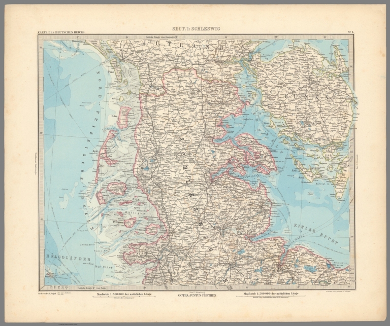
Sect. 1: Schleswig
List No
15961.003
Note
Sheets dated from 1891 to 1893.
Author
Vogel, Carl
Full Title
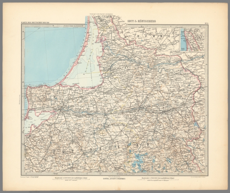
Sect. 5: Konigsberg.
List No
15961.007
Note
Sheets dated from 1891 to 1893.
Author
Vogel, Carl
Full Title
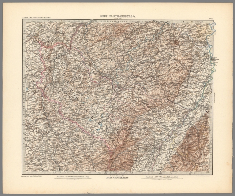
Sect. 22: Strassburg I/E
List No
15961.024
Note
Sheets dated from 1891 to 1893.
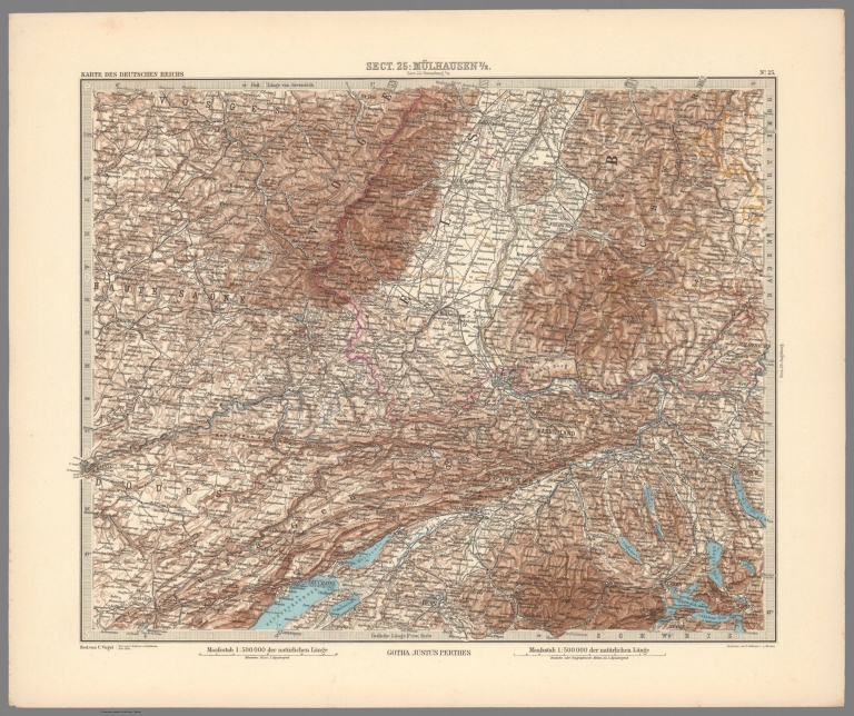
Author
Vogel, Carl
Full Title
Sect. 25: Mulhausen I/E
List No
15961.027
Note
Sheets dated from 1891 to 1893.
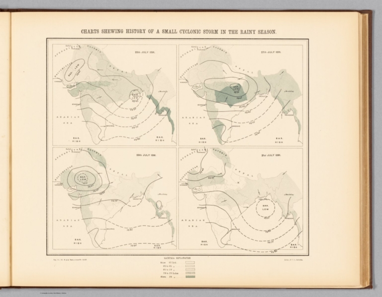
Author
Survey of India Department
Full Title
Charts shewing history of a small cyclonic storm in the rainy season : 25th July 1891 -- 27th July 1891 -- 29th July 1891 -- 31st July 1891. Reg. No. 131, R. & A. Dept. - June 94 - 2,016. Litho., S. I. O., Calcutta.
List No
14252.015
Note
Four lithographed climatic maps of India, illustrating a small cyclone in the rainy season (as recorded over four days in July of 1891), with color coding. Maps show rainfall in the storm (comparing each of the four days), as well as the boundaries of adjacent countries. Includes a legend and explanatory note. Together, maps are 26 x 31 cm, on sheet 34 x 43 cm.
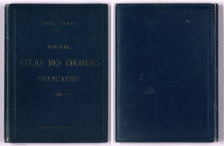
Pelet, Paul, 1849-1927; Challamel, Augus... Covers: Nouvel atlas des colonies Franç... 1891 14300.001 Related Author
[Pelet, Paul, 1849-1927, Challamel, Augustin, 1818-1894]
Full Title
(Covers to) Nouvel atlas des colonies Françaises. Paul Pelet. Augustin Challamel, Éditeur.
List No
14300.001
Note
Covers to Nouvel atlas des colonies Françaises by Paul Pelet, published in Paris, 1891. Title translates to: New atlas of the French colonies. Bound in navy-colored board with title, author and editor gilded on front cover. Spine title: P. Pelet. Nouvel atlas des colonies Françaises.
Pelet, Paul, 1849-1927; Challamel, Augus... Title: Nouvel atlas des colonies França... 1891 14300.003 Related Author
[Pelet, Paul, 1849-1927, Challamel, Augustin, 1818-1894]
Full Title
(Title Page to) Nouvel atlas des colonies Françaises dressé par ordre de l'Admiistration des Colonies par Paul Pelet, Professeur de Géographie Coloniale a l'École des Sciences Politiques Membre du Comité Géographique des Colonies. Paris, Augustin Challamel, Éditeur, Librairie Coloniale. 5, rue Jacob, et Rue Furstenberg, 2. 1891.
List No
14300.003
Note
Title page to Nouvel atlas des colonies Françaises by Paul Pelet, published in Paris, 1891. Title translates to: New atlas of the French colonies drawn up by order of the Administration of the Colonies by Paul Pelet, Professor of Colonial Geography at the School of Political Sciences, Member of the Geographical Committee of the Colonies. Includes imprint. Facing page has printing credit: Typographie Firmin-Didot et cie. Mesnil (Eure).
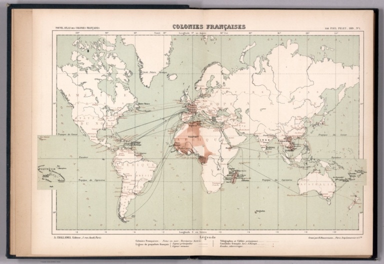
Author
[Pelet, Paul, 1849-1927, Challamel, Augustin, 1818-1894, Hausermann, R., active 1875-1915]
Full Title
Colonies Françaises. Nouvel atlas des colonies Françaises par Paul Pelet, 1889, No 1. A. Challamel, Éditeur, 5 rue Jacob, Paris. Gravé par R. Hausermann, Paris, Imp. Lemercier et Cie.
List No
14300.011
Note
World map showing French colonies around the world in 1889. Title translates to: French colonies. Features political boundaries, ocean transportation routes, telegraph and cable lines, as well as French consulates. Includes latitudinal and longitudinal lines and a legend. Colored lithograph. Map is 21 x 35 cm, on sheet 26 x 37 cm. Accompanied by descriptive text of the same title, on preceding pages in section I. In first part of atlas.
Author
[Pelet, Paul, 1849-1927, Challamel, Augustin, 1818-1894, Hausermann, R., active 1875-1915]
Full Title
France et Allgérie-Tunisie. Nouvel atlas des colonies Françaises par Paul Pelet, 1891, No 2. A. Challamel, Éditeur, 5 rue Jacob, Paris. Gravé par R. Hausermann, Paris, Imp. Lemercier et Cie.
List No
14300.014
Note
Map of France and Tunisia, including the vicinity. Shows place names, transportation routes, water transportation transportation routes between the two nations via the Mediterranean Sea, cable lines and elevation. Relief shown with shading. Includes latitudinal and longitudinal lines and a legend, as well as a bar scale and a scale statement. With inset map, comparing the distance of the journey - measured in hours - between Paris and Algiers, from 1830 to 1888: Accélération du voyage Paris-Alger, 1830-1888 [= Acceleration of the Paris-Algiers journey 1830-1888]. Colored lithograph. Map is 31 x 25 cm, on sheet 38 x 26 cm. Accompanied by descriptive text of the same title, on preceding pages in section II. In second part of atlas, Afrique.
Author
[Pelet, Paul, 1849-1927, Challamel, Augustin, 1818-1894, Hausermann, R., active 1875-1915]
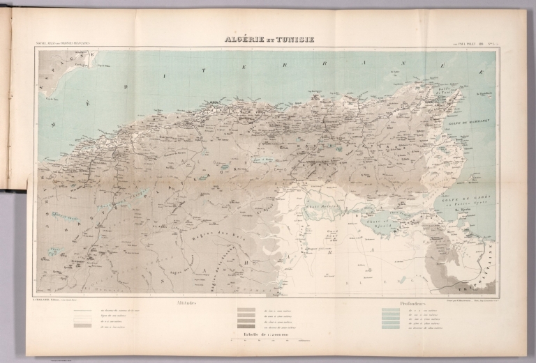
Full Title
Allgérie et Tunisie. Nouvel atlas des colonies Françaises par Paul Pelet, 1891, No 3-5. A. Challamel, Éditeur, 5 rue Jacob, Paris. Gravé par R. Hausermann, Paris, Imp. Lemercier et Cie.
List No
14300.018
Note
Map of Algeria and Tunisia, including the vicinity. Shows place names, transportation routes, topography, lakes, drainage, islands and water depths. Relief shown with shading. Includes latitudinal and longitudinal lines and a legend, as well as a bar scale and a scale statement. Colored lithograph. Map is 35 x 66 cm, on sheet 50 x 72 cm, folded to 25 x 17 cm. Accompanied by descriptive text of the same title, on preceding pages in section III, IV, V. In second part of atlas, Afrique.
Author
[Pelet, Paul, 1849-1927, Challamel, Augustin, 1818-1894, Hausermann, R., active 1875-1915]
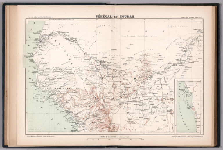
Full Title
Sénégal et Soudan. Nouvel atlas des colonies Françaises par Paul Pelet, 1889, No 6. A. Challamel, Éditeur, 5 rue Jacob, Paris. Gravé par R. Hausermann, Paris, Imp. Lemercier et Cie.
List No
14300.021
Note
Map of Senegal and Sudan, including the vicinity. Shows place names, transportation routes, topography, lakes, drainage, coastline and islands. Relief shown with hachures. Includes latitudinal and longitudinal lines, as well as a bar scale and a scale statement. With inset map: [Banc d'Arguin] [= Bay of Arguin]. Colored lithograph. Map is 21 x 34 cm, on sheet 26 x 37 cm. Accompanied by descriptive text of the same title, on preceding pages in section VI. In second part of atlas, Afrique.
Author
[Pelet, Paul, 1849-1927, Challamel, Augustin, 1818-1894, Hausermann, R., active 1875-1915]
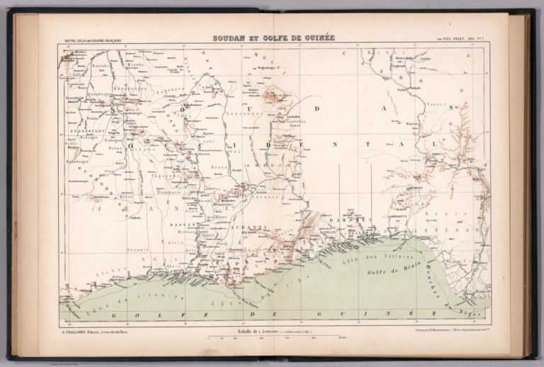
Full Title
Soudan et Golfe de Guinée. Nouvel atlas des colonies Françaises par Paul Pelet, 1889, No 7. A. Challamel, Éditeur, 5 rue Jacob, Paris. Gravé par R. Hausermann, Paris, Imp. Lemercier et Cie.
List No
14300.024
Note
Map of Sudan and the Gulf of Guinea, including the vicinity. Shows place names, transportation routes, topography, drainage, coastline and water transportation routes. Relief shown with hachures. Includes latitudinal and longitudinal lines, as well as a bar scale and a scale statement. Colored lithograph. Map is 21 x 33 cm, on sheet 26 x 37 cm. Accompanied by descriptive text of the same title, on preceding pages in section VII. In second part of atlas, Afrique.
Author
[Pelet, Paul, 1849-1927, Challamel, Augustin, 1818-1894, Hausermann, R., active 1875-1915]
Full Title
Gabon-Congo. Nouvel atlas des colonies Françaises par Paul Pelet, 1889, No 8. A. Challamel, Éditeur, 5 rue Jacob, Paris. Gravé par R. Hausermann, Paris, Imp. Lemercier et Cie.
List No
14300.027
Note
Map of Gabon and the Congo, including the vicinity. Shows place names, transportation routes, topography, drainage, coastline and islands. Relief shown with hachures. Includes latitudinal and longitudinal lines, as well as a bar scale and a scale statement. Colored lithograph. Map is 21 x 32 cm, on sheet 26 x 37 cm. Accompanied by descriptive text of the same title, on preceding pages in section VIII. In second part of atlas, Afrique.
Author
[Pelet, Paul, 1849-1927, Challamel, Augustin, 1818-1894, Hausermann, R., active 1875-1915]
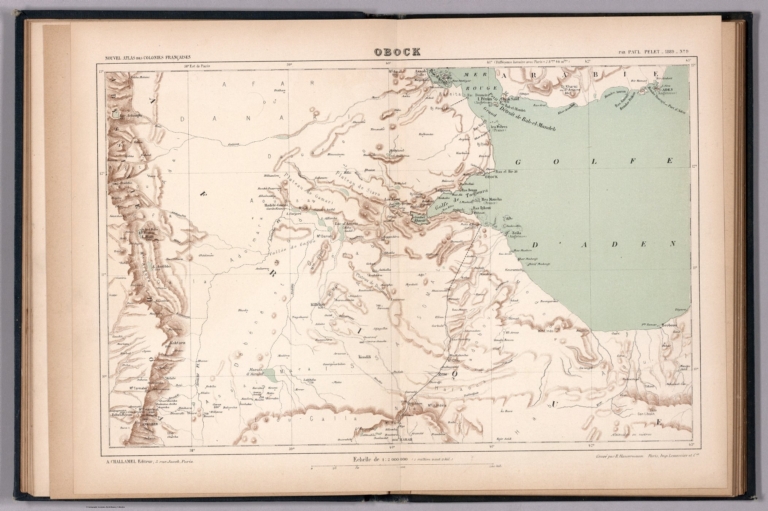
Full Title
Obock. Nouvel atlas des colonies Françaises par Paul Pelet, 1889, No 9. A. Challamel, Éditeur, 5 rue Jacob, Paris. Gravé par R. Hausermann, Paris, Imp. Lemercier et Cie.
List No
14300.029
Note
Map of Obock (Djibouti), including the vicinity. Shows place names, transportation routes, topography, drainage, coastline, islands and ports. Relief shown with hachures. Includes latitudinal and longitudinal lines, as well as a bar scale and a scale statement. Colored lithograph. Map is 21 x 32 cm, on sheet 26 x 37 cm. Accompanied by descriptive text of the same title, on preceding pages in section IX. In second part of atlas, Afrique.
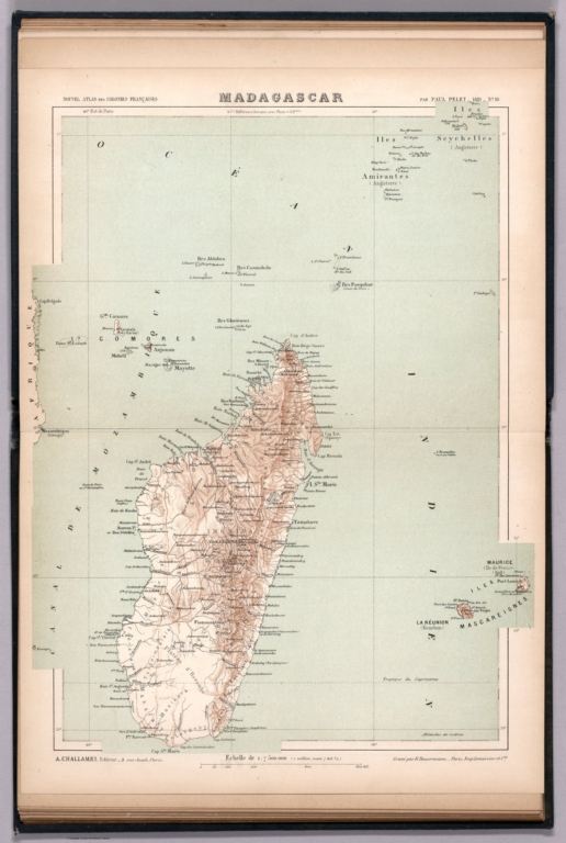
Author
[Pelet, Paul, 1849-1927, Challamel, Augustin, 1818-1894, Hausermann, R., active 1875-1915]
Full Title
Madagascar. Nouvel atlas des colonies Françaises par Paul Pelet, 1889, No 10. A. Challamel, Éditeur, 5 rue Jacob, Paris. Gravé par R. Hausermann, Paris, Imp. Lemercier et Cie.
List No
14300.032
Note
Map of Madagascar, including the vicinity. Shows place names, transportation routes, topography, drainage, coastlines, islands and ports. Relief shown with hachures. Includes latitudinal and longitudinal lines, as well as a bar scale and a scale statement. Colored lithograph. Map is 33 x 25 cm, on sheet 37 x 26 cm. Accompanied by descriptive text of the same title, on preceding pages in section X. In third part of atlas, Océan Indien.
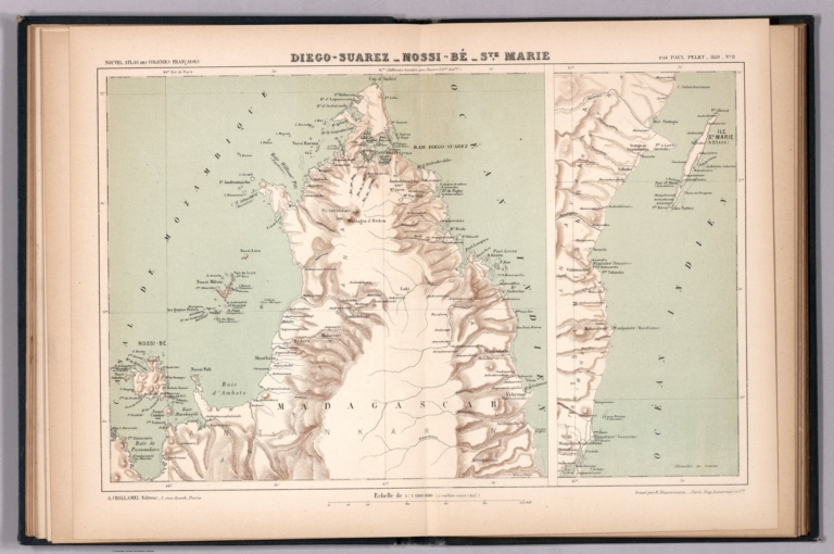
Pelet, Paul, 1849-1927; Challamel, Augus... Diego-Suarez, Nossi-Bé, Ste. Marie. 1889 14300.035 Related Author
[Pelet, Paul, 1849-1927, Challamel, Augustin, 1818-1894, Hausermann, R., active 1875-1915]
Full Title
Diego-Suarez, Nossi-Bé, Ste. Marie. Nouvel atlas des colonies Françaises par Paul Pelet, 1889, No 11. A. Challamel, Éditeur, 5 rue Jacob, Paris. Gravé par R. Hausermann, Paris, Imp. Lemercier et Cie.
List No
14300.035
Note
Map of Diego-Suarez [current-day Antsiranana], and the Nossi-Bé [Nosy-Be] and Sainte-Marie islands of Madagascar. Shows place names, transportation routes, topography, drainage, coastlines, islands and ports. Relief shown with hachures. Includes latitudinal and longitudinal lines, as well as a bar scale and a scale statement. Colored lithograph. Map appears in two parts, which, together, are 21 x 32 cm, on sheet 26 x 37 cm. Accompanied by descriptive text of the same title, on preceding pages in section XI. In third part of atlas, Océan Indien.
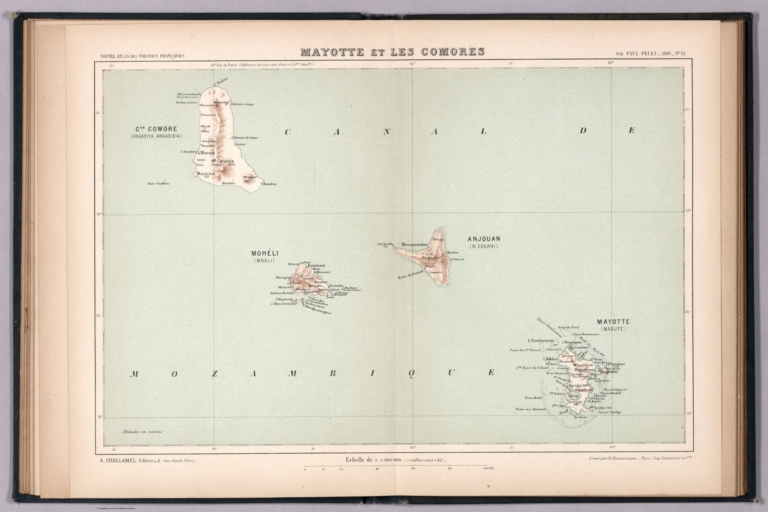
Author
[Pelet, Paul, 1849-1927, Challamel, Augustin, 1818-1894, Hausermann, R., active 1875-1915]
Full Title
Mayotte et les Comores. Nouvel atlas des colonies Françaises par Paul Pelet, 1889, No 12. A. Challamel, Éditeur, 5 rue Jacob, Paris. Gravé par R. Hausermann, Paris, Imp. Lemercier et Cie.
List No
14300.038
Note
Map of Mayotte and the Comoros. Shows place names, transportation routes, topography, drainage, coastlines, islands and ports. Relief shown with hachures. Includes latitudinal and longitudinal lines, as well as a bar scale and a scale statement. Colored lithograph. Map is 21 x 32 cm, on sheet 26 x 37 cm. Accompanied by descriptive text of the same title, on preceding pages in section XII. In third part of atlas, Océan Indien.
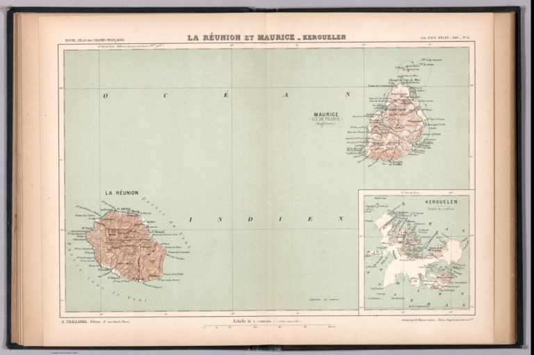
Pelet, Paul, 1849-1927; Challamel, Augus... La Réunion et Maurice, Kerguelen. 1889 14300.041 Related Author
[Pelet, Paul, 1849-1927, Challamel, Augustin, 1818-1894, Hausermann, R., active 1875-1915]
Full Title
La Réunion et Maurice, Kerguelen. Nouvel atlas des colonies Françaises par Paul Pelet, 1889, No 13. A. Challamel, Éditeur, 5 rue Jacob, Paris. Gravé par R. Hausermann, Paris, Imp. Lemercier et Cie.
List No
14300.041
Note
Map of Réunion, Mauritius and the Kerguelen Islands. Shows place names, transportation routes, topography, drainage, coastlines, islands and ports. Relief shown with hachures. Includes latitudinal and longitudinal lines, as well as a bar scale and a scale statement. Colored lithograph. Map appears in two parts, which, together, are 21 x 32 cm, on sheet 26 x 37 cm. Accompanied by descriptive text of the same title, on preceding pages in section XIII. In third part of atlas, Océan Indien.
Author
[Pelet, Paul, 1849-1927, Challamel, Augustin, 1818-1894, Hausermann, R., active 1875-1915]
Full Title
Inde. Nouvel atlas des colonies Françaises par Paul Pelet, 1889, No 14. A. Challamel, Éditeur, 5 rue Jacob, Paris. Gravé par R. Hausermann, Paris, Imp. Lemercier et Cie.
List No
14300.044
Note
Map of India and the vicinity. Shows place names, transportation routes, topography, lakes, drainage, coastlines, islands and ports. Relief shown with hachures. Includes latitudinal and longitudinal lines, as well as a bar scale and a scale statement. With inset map [India and greater vicinity]. Colored lithograph. Map appears in two parts, which, together, are 32 x 22 cm, on sheet 37 x 26 cm. Accompanied by descriptive text of the same title, on preceding pages in section XIV. In third part of atlas, Océan Indien.
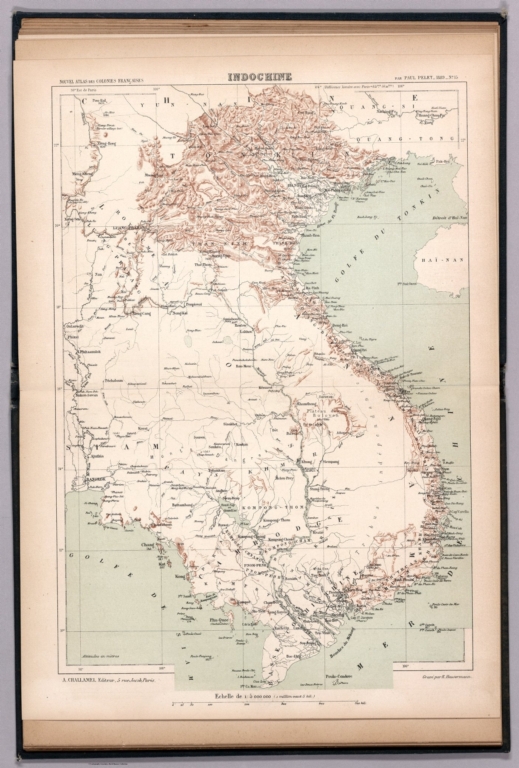
Author
[Pelet, Paul, 1849-1927, Challamel, Augustin, 1818-1894, Hausermann, R., active 1875-1915]
Full Title
Indochine. Nouvel atlas des colonies Françaises par Paul Pelet, 1889, No 15. A. Challamel, Éditeur, 5 rue Jacob, Paris. Gravé par R. Hausermann, Paris, Imp. Lemercier et Cie.
List No
14300.048
Note
Map of Indochina and the vicinity. Shows place names, transportation routes, topography, lakes, drainage, coastlines, islands and ports. Relief shown with hachures. Includes latitudinal and longitudinal lines, as well as a bar scale and a scale statement. Colored lithograph. Map is 33 x 22 cm, on sheet 37 x 26 cm. Accompanied by descriptive text of the same title, on preceding pages in section XV. In fourth part of atlas, Indochine.
Author
[Pelet, Paul, 1849-1927, Challamel, Augustin, 1818-1894, Hausermann, R., active 1875-1915]
Full Title
Cochinchine et Cambodge. Nouvel atlas des colonies Françaises par Paul Pelet, 1889, No 16. A. Challamel, Éditeur, 5 rue Jacob, Paris. Gravé par R. Hausermann, Paris, Imp. Lemercier et Cie.
List No
14300.051
Note
Map of French Cochinchina (French Indochina) and the vicinity. Shows place names, transportation routes, topography, lakes, drainage, coastlines, canals and islands. Relief shown with hachures. Includes latitudinal and longitudinal lines, as well as a bar scale and a scale statement. Colored lithograph. Map is 32 x 23 cm, on sheet 37 x 26 cm. Accompanied by descriptive text of the same title, on preceding pages in section XVI. In fourth part of atlas, Indochine.
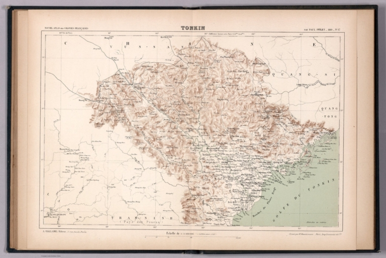
Author
[Pelet, Paul, 1849-1927, Challamel, Augustin, 1818-1894, Hausermann, R., active 1875-1915]
Full Title
Tonkin. Nouvel atlas des colonies Françaises par Paul Pelet, 1889, No 17. A. Challamel, Éditeur, 5 rue Jacob, Paris. Gravé par R. Hausermann, Paris, Imp. Lemercier et Cie.
List No
14300.054
Note
Map of Tonkin (Vietnam) and the vicinity. Shows place names, transportation routes, topography, lakes, drainage, coastlines and islands. Relief shown with hachures. Includes latitudinal and longitudinal lines, as well as a bar scale and a scale statement. Colored lithograph. Map is 21 x 32 cm, on sheet 26 x 37 cm. Accompanied by descriptive text of the same title, on preceding pages in section XVII. In fourth part of atlas, Indochine.
Author
[Pelet, Paul, 1849-1927, Challamel, Augustin, 1818-1894, Hausermann, R., active 1875-1915]
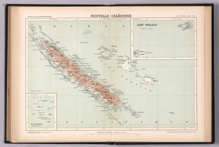
Full Title
Nouvelle Calédonie. Nouvel atlas des colonies Françaises par Paul Pelet, 1889, No 18. A. Challamel, Éditeur, 5 rue Jacob, Paris. Gravé par R. Hausermann, Paris, Imp. Lemercier et Cie.
List No
14300.057
Note
Map of New Caledonia and the vicinity. Shows place names, transportation routes, topography, lakes, drainage, coastlines, canals and islands. Relief shown with hachures. Includes latitudinal and longitudinal lines, as well as a bar scale and a scale statement. With two inset maps: Iles Chesterfield -- Iles Wallis. Colored lithograph. Map is 21 x 32 cm, on sheet 26 x 37 cm. Accompanied by descriptive text of the same title, on preceding pages in section XVIII. In fifth part of atlas, Océanie.
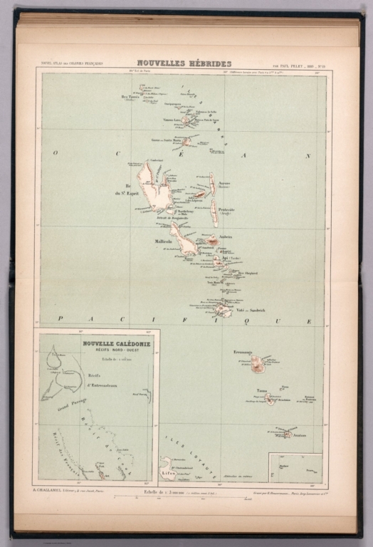
Author
[Pelet, Paul, 1849-1927, Challamel, Augustin, 1818-1894, Hausermann, R., active 1875-1915]
Full Title
Nouvelle Hébrides. Nouvel atlas des colonies Françaises par Paul Pelet, 1889, No 19. A. Challamel, Éditeur, 5 rue Jacob, Paris. Gravé par R. Hausermann, Paris, Imp. Lemercier et Cie.
List No
14300.060
Note
Map of New Hebrides and the vicinity. Shows place names, transportation routes, topography, lakes, drainage, coastlines and islands. Relief shown with hachures. Includes latitudinal and longitudinal lines, as well as a bar scale and a scale statement. With two inset maps: Nouvelle Calédonie : Récifs Nord-Ouest [= New Caledonia: North-West Reefs] -- [Matthew and Fearn Islands]. Colored lithograph. Map is 31 x 22 cm, on sheet 37 x 26 cm. Accompanied by descriptive text of the same title, on preceding pages in section XIX. In fifth part of atlas, Océanie.
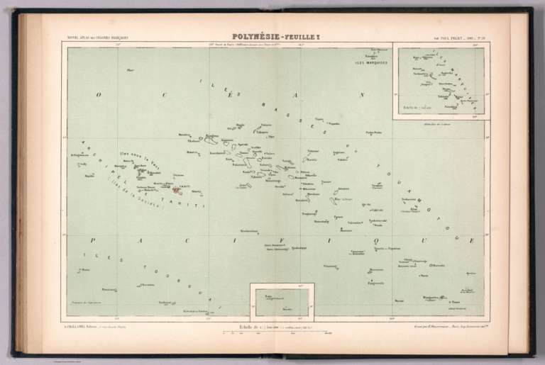
Author
[Pelet, Paul, 1849-1927, Challamel, Augustin, 1818-1894, Hausermann, R., active 1875-1915]
Full Title
Polynésie-Feuille I. Nouvel atlas des colonies Françaises par Paul Pelet, 1889, No 20. A. Challamel, Éditeur, 5 rue Jacob, Paris. Gravé par R. Hausermann, Paris, Imp. Lemercier et Cie.
List No
14300.063
Note
Map of Polynesia and the vicinity. Shows place names, transportation routes, topography, lakes, drainage, coastlines and islands. Relief shown with hachures. Includes latitudinal and longitudinal lines, as well as a bar scale and a scale statement. With two inset maps: [Rapa and Marotiri Islands] -- Iles Marquises [= Marquesas Islands]. Colored lithograph. Map is 21 x 32 cm, on sheet 26 x 37 cm. First of two maps showing Polynesia; second map on subsequent plate (No 21). Accompanied by descriptive text of the same title, on preceding pages in section XX, XXI. In fifth part of atlas, Océanie.
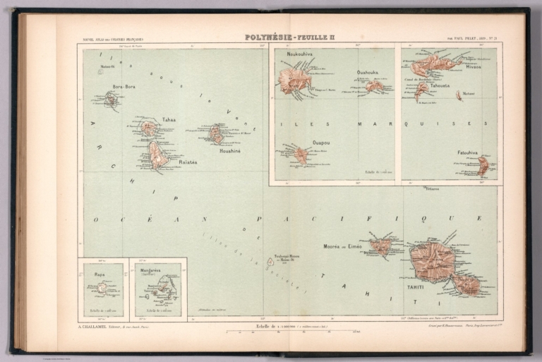
Author
[Pelet, Paul, 1849-1927, Challamel, Augustin, 1818-1894, Hausermann, R., active 1875-1915]
Full Title
Polynésie-Feuille II. Nouvel atlas des colonies Françaises par Paul Pelet, 1889, No 21. A. Challamel, Éditeur, 5 rue Jacob, Paris. Gravé par R. Hausermann, Paris, Imp. Lemercier et Cie.
List No
14300.064
Note
Map of Polynesia and the vicinity. Shows place names, transportation routes, topography, lakes, drainage, coastlines and islands. Relief shown with hachures. Includes latitudinal and longitudinal lines, as well as a bar scale and a scale statement. With four inset maps: Rapa -- Mangaréva (Gambier) -- Iles Marquises [: Noukouhiva, Ouahouka and Ouapou] -- Iles Marquises [: Tahouata, Hivaoa and Fatouhiva]. Colored lithograph. Map is 21 x 32 cm, on sheet 26 x 37 cm. Second of two maps showing Polynesia; first map on preceding plate (No 20). Accompanied by descriptive text of the same title, on preceding pages in section XX, XXI. In fifth part of atlas, Océanie.
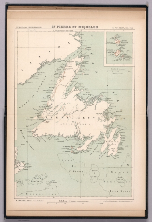
Author
[Pelet, Paul, 1849-1927, Challamel, Augustin, 1818-1894, Hausermann, R., active 1875-1915]
Full Title
St. Pierre et Miquelon. Nouvel atlas des colonies Françaises par Paul Pelet, 1889, No 22. A. Challamel, Éditeur, 5 rue Jacob, Paris. Gravé par R. Hausermann, Paris, Imp. Lemercier et Cie.
List No
14300.067
Note
Map of the Saint-Pierre and Miquelon Islands and the vicinity. Shows place names, transportation routes, topography, lakes, drainage, coastlines and islands. Relief shown with hachures. Includes latitudinal and longitudinal lines, as well as a bar scale and a scale statement. With inset map: [Langlade ou Petite Miquelon, Grande Miquelon and St. Pierre]. Colored lithograph. Map is 31 x 22 cm, on sheet 37 x 26 cm. Accompanied by descriptive text of the same title, on preceding pages in section XXII. In sixth part of atlas, Amérique.
Author
[Pelet, Paul, 1849-1927, Challamel, Augustin, 1818-1894, Hausermann, R., active 1875-1915]
Full Title
Guadeloupe et Martinique. Nouvel atlas des colonies Françaises par Paul Pelet, 1889, No 23. A. Challamel, Éditeur, 5 rue Jacob, Paris. Gravé par R. Hausermann, Paris, Imp. Lemercier et Cie.
List No
14300.070
Note
Map of the Guadeloupe and Martinique Islands and the vicinity. Shows place names, transportation routes, topography, lakes, drainage, coastlines and islands. Relief shown with hachures. Includes latitudinal and longitudinal lines, as well as a bar scale and a scale statement. With inset map: [Anguille, St. Martin and St. Barthélemy]. Colored lithograph. Map is 31 x 22 cm, on sheet 37 x 26 cm. Accompanied by descriptive text of the same title, on preceding pages in section XXIII. In sixth part of atlas, Amérique.
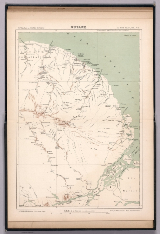
Author
[Pelet, Paul, 1849-1927, Challamel, Augustin, 1818-1894, Hausermann, R., active 1875-1915]
Full Title
Guyane. Nouvel atlas des colonies Françaises par Paul Pelet, 1889, No 24. A. Challamel, Éditeur, 5 rue Jacob, Paris. Gravé par R. Hausermann, Paris, Imp. Lemercier et Cie.
List No
14300.073
Note
Map of Guyana and the vicinity. Shows place names, transportation routes, topography, lakes, drainage, coastlines and islands. Relief shown with hachures. Includes latitudinal and longitudinal lines, as well as a bar scale and a scale statement. Colored lithograph. Map is 31 x 22 cm, on sheet 37 x 26 cm. Accompanied by descriptive text of the same title, on preceding pages in section XXIV. In sixth part of atlas, Amérique.
Author
Johnston, W. & A.K.
Full Title
(Covers to) General Map Of North America Constructed From The Best Authorities, And Embodying The Results Of All Explorations To The Present Time. By W. & A.K. Johnston, Geographers to the Queen. Edinburgh And London. 1891. Engraved & Printed by W. & A.K. Johnston, Edinburgh & London. (inset) The Atlantic States Between Washington & Boston ... (inset) Aleutian Islands.
List No
3790.001
Author
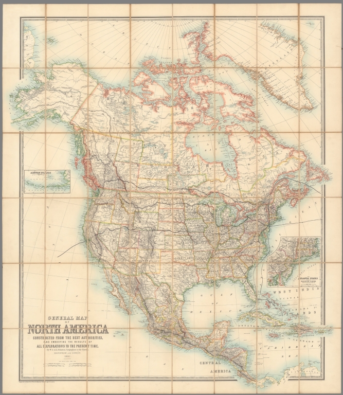
Johnston, W. & A.K.
Full Title
General Map Of North America Constructed From The Best Authorities, And Embodying The Results Of All Explorations To The Present Time. By W. & A.K. Johnston, Geographers to the Queen. Edinburgh And London. 1891. Engraved & Printed by W. & A.K. Johnston, Edinburgh & London. (inset) The Atlantic States Between Washington & Boston ... (inset) Aleutian Islands.
List No
3790.002
Author
Henze, Adolf
Full Title
(Covers to) [Henze's Erd-Globus].
List No
14361.001
Note
Covers to Henze's Erd-Globus. Title translates to: Henze's earth globe. Bound in black board, with reinforced spine and corners (now abraded). Empty cartouche on front cover.
Author
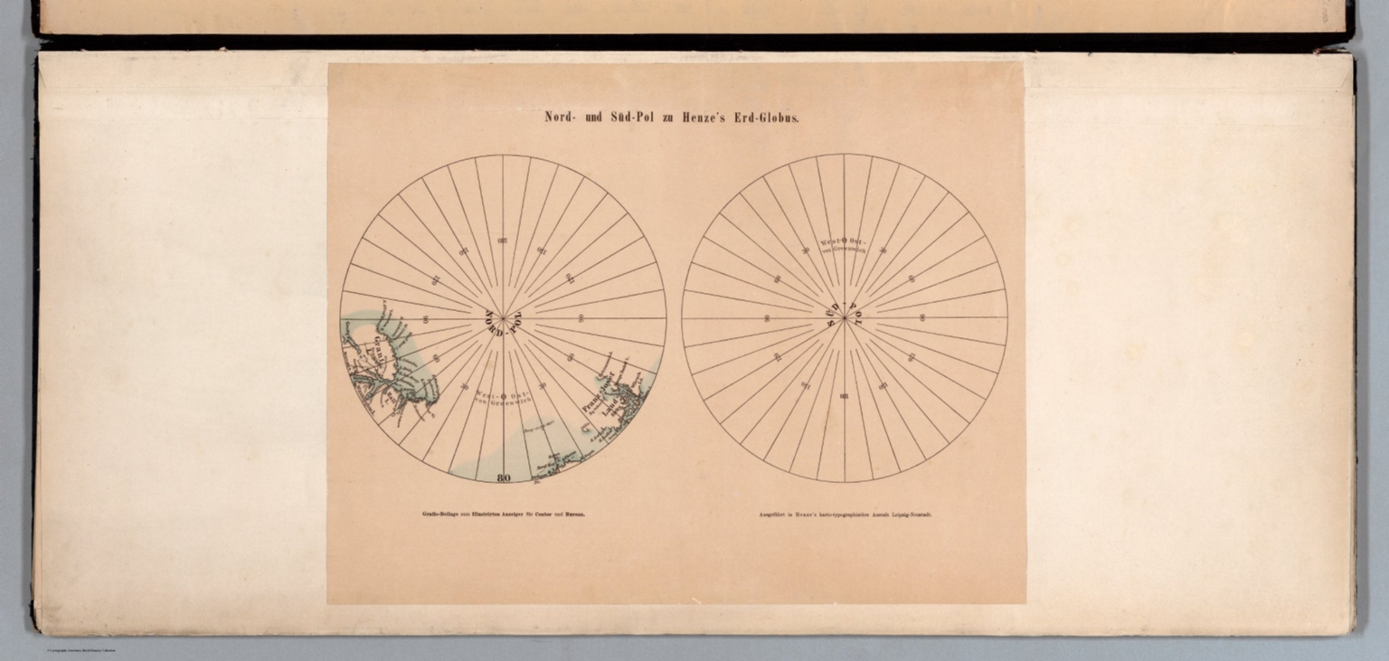
Henze, Adolf
Full Title
Nord- und Süd-Pol zu Henze's Erd-Globus. Gratis-Beilage zum Illustrirten Anzeiger für Contor und Bureau. Ausgeführt in Henze's karto-typographischer Anstalt Leipzig-Neustadt.
List No
14361.002
Note
Two maps of the North and South Poles. Shows topography, coastlines and islands. Relief shown with hachures. Includes longitudinal lines. Colored lithograph. Maps are each 19 x 19 cm, on sheet 31 x 40 cm. Maps precede globe gores.
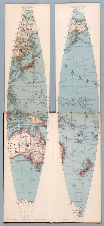
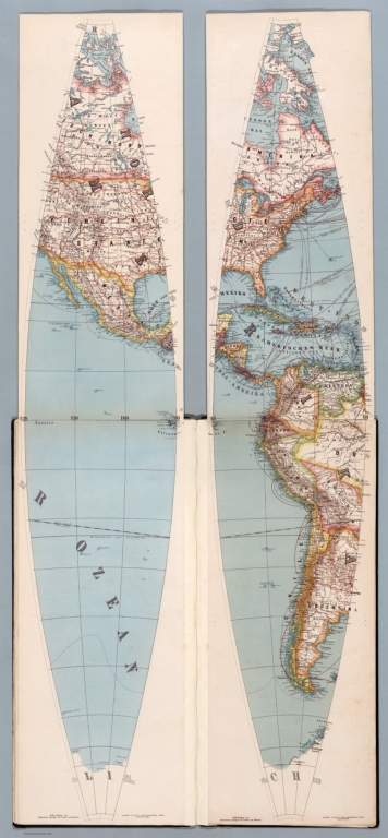
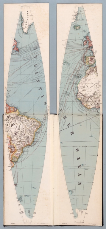
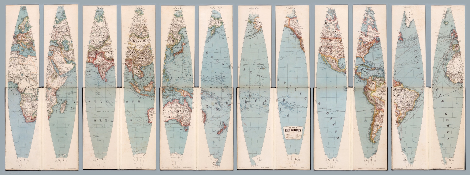
Author
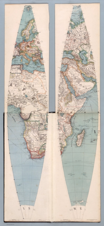
Henze, Adolf
Full Title
Henze's Erd-Globus im Verhältniss wie 1/12,000,000 zur natürlichen Grösse. Druck u. Verlag von Adolf Henze in Neustadt-Leipzig. Gratis-Beilage zum "Illustrirten Anzeiger für Contor und Bureau." Ausgeführt in Henze's karto-typographischer Anstalt Leipzig-Neustadt. (1)
List No
14361.003
Note
First and second globe gores for world map. Map shows political boundaries, cities, railways, roads, ocean routes, major international telegraph lines, population, languages spoken, topography, glaciers, deserts, bodies of water, drainage, coastlines, islands and the date change line. Relief shown with hachures. Includes latitudinal and longitudinal lines. Title cartouche, legend and key appear on eighth sheet. Gores are each 146 x 28, each on a sheet 150 x 31 cm. Gores appear on twelve sheets bound together.
Author
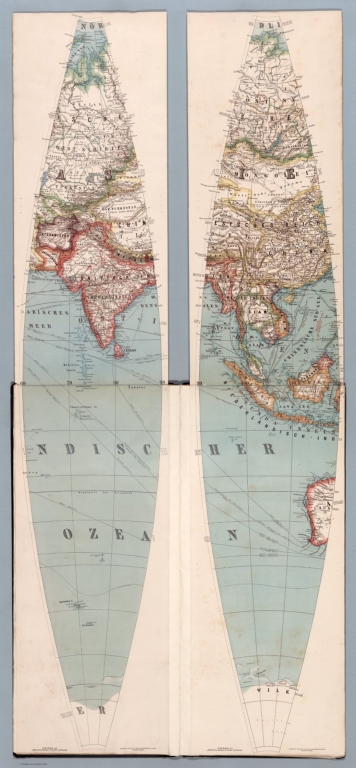
Henze, Adolf
Full Title
Henze's Erd-Globus im Verhältniss wie 1/12,000,000 zur natürlichen Grösse. Druck u. Verlag von Adolf Henze in Neustadt-Leipzig. Gratis-Beilage zum "Illustrirten Anzeiger für Contor und Bureau." Ausgeführt in Henze's karto-typographischer Anstalt Leipzig-Neustadt. (2)
List No
14361.004
Note
Third and fourth globe gores for world map. Map shows political boundaries, cities, railways, roads, ocean routes, major international telegraph lines, population, languages spoken, topography, glaciers, deserts, bodies of water, drainage, coastlines, islands and the date change line. Relief shown with hachures. Includes latitudinal and longitudinal lines. Title cartouche, legend and key appear on eighth sheet. Gores are each 146 x 28, each on a sheet 150 x 31 cm. Gores appear on twelve sheets bound together.
Author
Henze, Adolf
Full Title
Henze's Erd-Globus im Verhältniss wie 1/12,000,000 zur natürlichen Grösse. Druck u. Verlag von Adolf Henze in Neustadt-Leipzig. Gratis-Beilage zum "Illustrirten Anzeiger für Contor und Bureau." Ausgeführt in Henze's karto-typographischer Anstalt Leipzig-Neustadt. (3)
List No
14361.005
Note
Fifth and sixth globe gores for world map. Map shows political boundaries, cities, railways, roads, ocean routes, major international telegraph lines, population, languages spoken, topography, glaciers, deserts, bodies of water, drainage, coastlines, islands and the date change line. Relief shown with hachures. Includes latitudinal and longitudinal lines. Title cartouche, legend and key appear on eighth sheet. Gores are each 146 x 28, each on a sheet 150 x 31 cm. Gores appear on twelve sheets bound together.
Author
Henze, Adolf
Full Title
Henze's Erd-Globus im Verhältniss wie 1/12,000,000 zur natürlichen Grösse. Druck u. Verlag von Adolf Henze in Neustadt-Leipzig. Gratis-Beilage zum "Illustrirten Anzeiger für Contor und Bureau." Ausgeführt in Henze's karto-typographischer Anstalt Leipzig-Neustadt. (4)
List No
14361.006
Note
Seventh and eighth globe gores for world map. Map shows political boundaries, cities, railways, roads, ocean routes, major international telegraph lines, population, languages spoken, topography, glaciers, deserts, bodies of water, drainage, coastlines, islands and the date change line. Relief shown with hachures. Includes latitudinal and longitudinal lines. Title cartouche, legend and key appear on eighth sheet. Gores are each 146 x 28, each on a sheet 150 x 31 cm. Gores appear on twelve sheets bound together.
Author
Henze, Adolf
Full Title
Henze's Erd-Globus im Verhältniss wie 1/12,000,000 zur natürlichen Grösse. Druck u. Verlag von Adolf Henze in Neustadt-Leipzig. Gratis-Beilage zum "Illustrirten Anzeiger für Contor und Bureau." Ausgeführt in Henze's karto-typographischer Anstalt Leipzig-Neustadt. (5)
List No
14361.007
Note
Ninth and tenth globe gores for world map. Map shows political boundaries, cities, railways, roads, ocean routes, major international telegraph lines, population, languages spoken, topography, glaciers, deserts, bodies of water, drainage, coastlines, islands and the date change line. Relief shown with hachures. Includes latitudinal and longitudinal lines. Title cartouche, legend and key appear on eighth sheet. Gores are each 146 x 28, each on a sheet 150 x 31 cm. Gores appear on twelve sheets bound together.
Author
Henze, Adolf
Full Title
Henze's Erd-Globus im Verhältniss wie 1/12,000,000 zur natürlichen Grösse. Druck u. Verlag von Adolf Henze in Neustadt-Leipzig. Gratis-Beilage zum "Illustrirten Anzeiger für Contor und Bureau." Ausgeführt in Henze's karto-typographischer Anstalt Leipzig-Neustadt. (6)
List No
14361.008
Note
Eleventh and twelfth globe gores for world map. Map shows political boundaries, cities, railways, roads, ocean routes, major international telegraph lines, population, languages spoken, topography, glaciers, deserts, bodies of water, drainage, coastlines, islands and the date change line. Relief shown with hachures. Includes latitudinal and longitudinal lines. Title cartouche, legend and key appear on eighth sheet. Gores are each 146 x 28, each on a sheet 150 x 31 cm. Gores appear on twelve sheets bound together.
Author
Henze, Adolf
Full Title
(Composite Map to) Henze's Erd-Globus im Verhältniss wie 1/12,000,000 zur natürlichen Grösse. Druck u. Verlag von Adolf Henze in Neustadt-Leipzig. Gratis-Beilage zum "Illustrirten Anzeiger für Contor und Bureau." Ausgeführt in Henze's karto-typographischer Anstalt Leipzig-Neustadt.
List No
14361.009
Note
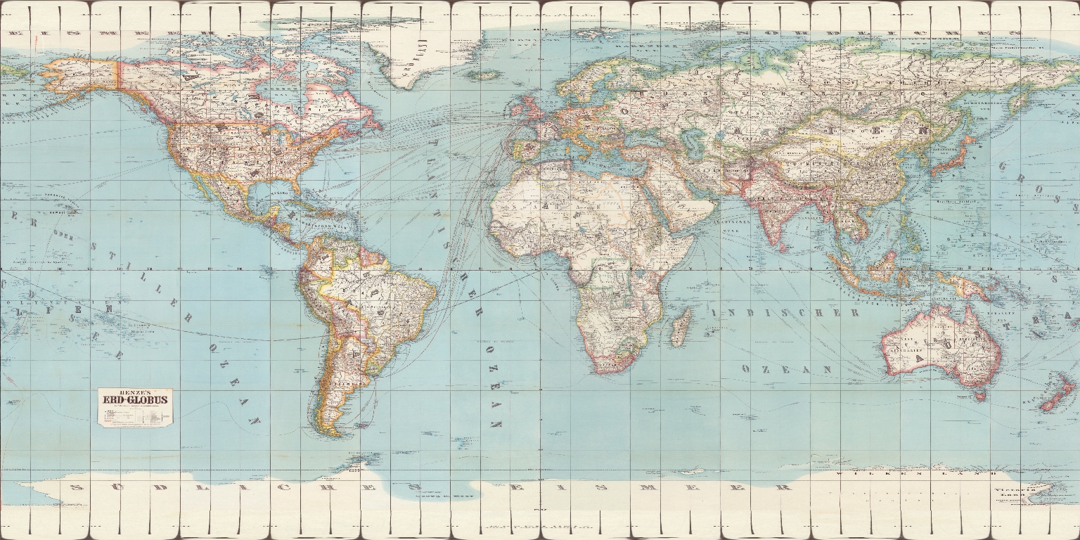
World map composed of twelve globe gores. Map shows political boundaries, cities, railways, roads, ocean routes, major international telegraph lines, population, languages spoken, topography, glaciers, deserts, bodies of water, drainage, coastlines, islands and the date change line. Relief shown with hachures. Includes latitudinal and longitudinal lines. Title cartouche, legend and key appear on eighth sheet. Gores are each 146 x 28, each on a sheet 150 x 31 cm. Gores bound together.
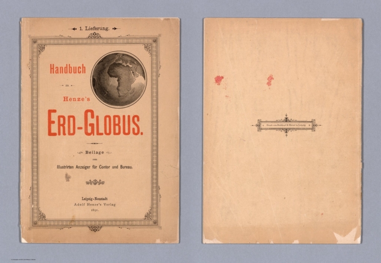
Author
Henze, Adolf
Full Title
(Covers to) Handbuch zu Henze's Erd-Globus. Beilage zum Illustrirten Anzeiger für Contor und Bureau. Leipzig-Neustadt. Adolf Henze's Verlag. 1891.
List No
14363.001
Note
Front cover to Handbuch zu Henze's Erd-Globus. Title translates to: Handbook for Henze's Earth Globe ... Includes a world map, centered on Africa. With decorative border. "1. Lieferung" [= First delivery] at top of sheet. Bound in paper.
Author
Henze, Adolf
Full Title
(Text Page to) Vorwort.
List No
14363.002
Note
Foreward to Handbuch zu Henze's Erd-Globus. Text begins: Die ungewöhnliche Grösse unseres "Globus" macht es schwierig, Orts- und andere Namen ohne nähere Bezeichnung aufzufinden [= The unusual size of our "globe" makes it difficult to find place names and other names without further reference].
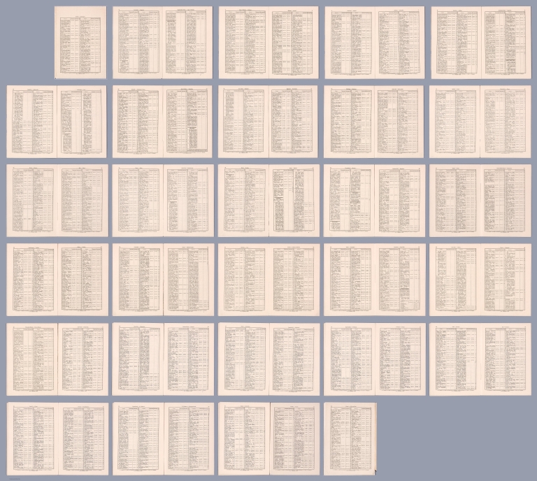
Author
Henze, Adolf
Full Title
(Composite Text to) Aachen - Golf von Boni, Niederländisch-Indien, Celebes.
List No
14363.003
Note
Composite view of index to Handbuch zu Henze's Erd-Globus. Lists place names, corresponding to globe, in alphabetical order, with longitudinal and latitudinal coordinate points, as well as section numbers. Includes key for abbreviations at bottom of each sheet. Spans 56 pages. (Page number [1] inferred.)
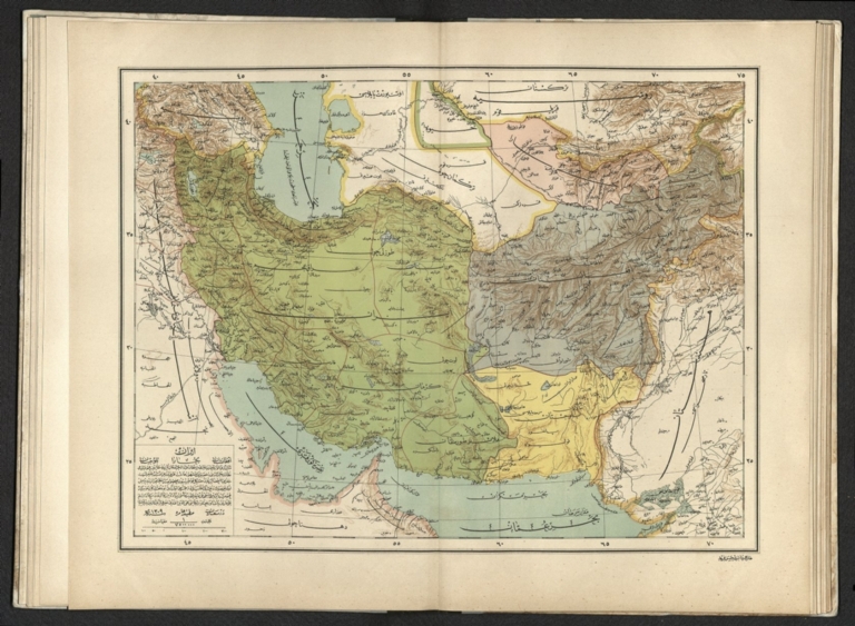
Author
[Pasa, Ali Seref, Esref, Hafiz Ali]
Full Title
Iran : Afganistan; Buhara; Belochistan. 1309 (1891). Tabie ve Nnashiri Hasan Ferid. (to accompany) Yeni cografya atlasi - ىگى جغرافىا آطلسى = New geographical atlas. Dersa'adet (Istanbul), 1307-1309 (1891-1893).
List No
13621.024
Note
Map of Iran, Afghanistan, Pakistan and Uzbekistan.
Author
Ottoman War Ministry Press
Full Title
كريد جزيره سى ختيطه سى [Map of the Island Krete].
List No
10874.000
Note
Dated 1307 [1891].
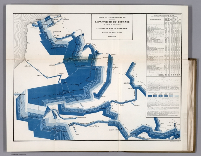
Ministere des Travaux Publics; Cheysson,... Tonnage des Voies Navigables en 1889. Re... 1891 12521.019 Related Author
[Ministere des Travaux Publics, Cheysson, Émile]
Full Title
Tonnage des Voies Navigables en 1889. Repartition du Tonnage ... I. Region du Nord et du Nord-Est. (Breakdown of the tonnage of inland waterways in 1889 by nature of goods: Area of North.)
List No
12521.019
Author
Henze, Adolf
Full Title
Interactive Globe: Henze's Erd-Globus.
List No
10681.027
Note
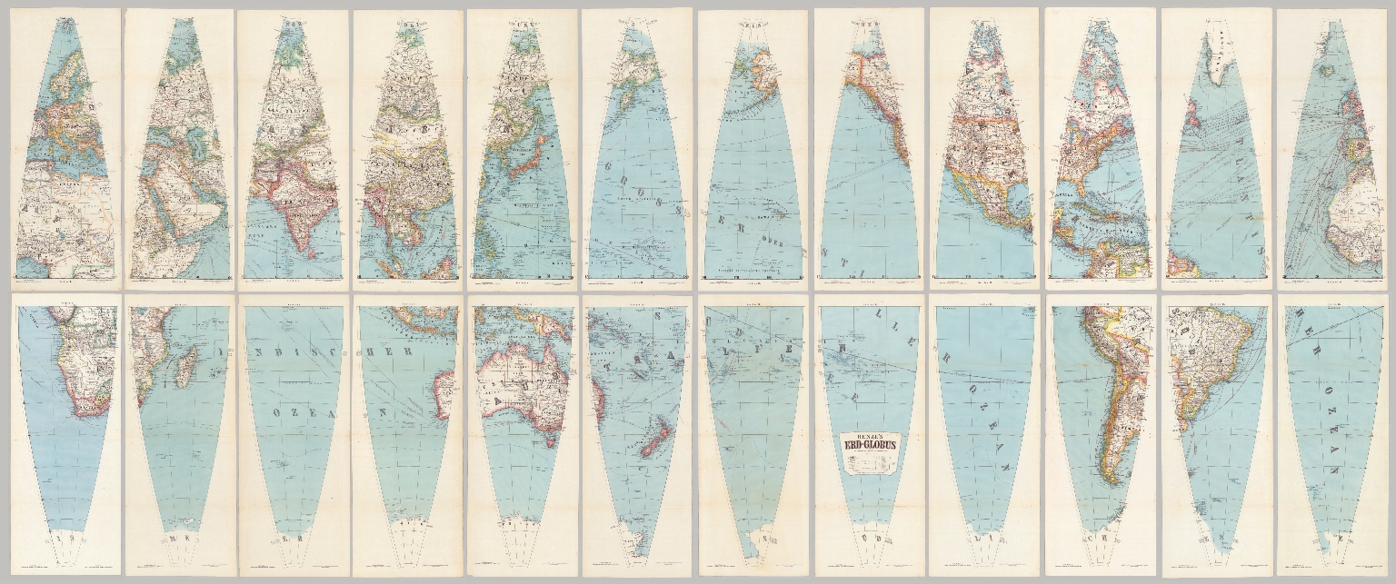
Interactive Globe of georeferenced globe gores. With a diameter of 43 inches, these 24 gores form the largest printed globe produced in the 19th century.Dimensions are sheet size.
Author
Henze, Adolf
Full Title
Sections 1-24 Henze's Erd-Globus.
List No
10681.026
Note
With a diameter of 43 inches, these 24 gores form the largest printed globe produced in the 19th century. Composite of 24 globe gores. Dimensions are sheet size.
Author
Henze, Adolf
Full Title
Geographic Projection: Sections 1-24 Henze's Erd-Globus.
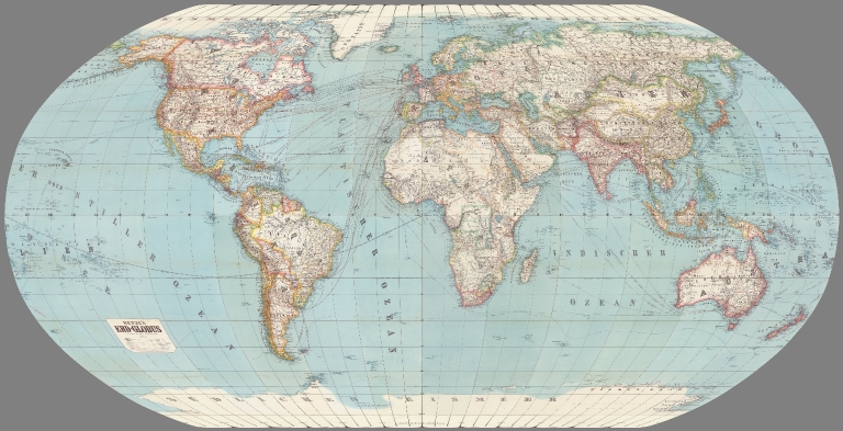
List No
10681.028
Note
With a diameter of 43 inches, these 24 gores form the largest printed globe produced in the 19th century. Composite of 24 globe gores. Dimensions are sheet size.
Author
Henze, Adolf
Full Title
Robinson Projection: Sections 1-24 Henze's Erd-Globus.
List No
10681.029
Note
With a diameter of 43 inches, these 24 gores form the largest printed globe produced in the 19th century. Composite of 24 globe gores. Dimensions are sheet size.
|


![Covers: [Henze's Erd-Globus].](https://media.davidrumsey.com/MediaManager/srvr?mediafile=/Size3/RUMSEY~8~1/199/14361001.jpg)


![كريد جزيره سى ختيطه سى [Map of the Island Krete].](https://media.davidrumsey.com/MediaManager/srvr?mediafile=/Size4/RUMSEY~8~1/195/10874000.jpg)