|
Author
Vogel, Carl
Full Title
Sect. 1: Schleswig
List No
15961.003
Note
Sheets dated from 1891 to 1893.
Author
Vogel, Carl
Full Title
Sect. 5: Konigsberg.
List No
15961.007
Note
Sheets dated from 1891 to 1893.
Author
Vogel, Carl
Full Title
Sect. 22: Strassburg I/E
List No
15961.024
Note
Sheets dated from 1891 to 1893.
Author
Vogel, Carl
Full Title
Sect. 25: Mulhausen I/E
List No
15961.027
Note
Sheets dated from 1891 to 1893.
Author
Survey of India Department
Full Title
Charts shewing history of a small cyclonic storm in the rainy season : 25th July 1891 -- 27th July 1891 -- 29th July 1891 -- 31st July 1891. Reg. No. 131, R. & A. Dept. - June 94 - 2,016. Litho., S. I. O., Calcutta.
List No
14252.015
Note
Four lithographed climatic maps of India, illustrating a small cyclone in the rainy season (as recorded over four days in July of 1891), with color coding. Maps show rainfall in the storm (comparing each of the four days), as well as the boundaries of adjacent countries. Includes a legend and explanatory note. Together, maps are 26 x 31 cm, on sheet 34 x 43 cm.
Author
[Pelet, Paul, 1849-1927, Challamel, Augustin, 1818-1894]
Full Title
(Covers to) Nouvel atlas des colonies Françaises. Paul Pelet. Augustin Challamel, Éditeur.
List No
14300.001
Note
Covers to Nouvel atlas des colonies Françaises by Paul Pelet, published in Paris, 1891. Title translates to: New atlas of the French colonies. Bound in navy-colored board with title, author and editor gilded on front cover. Spine title: P. Pelet. Nouvel atlas des colonies Françaises.
Author
[Pelet, Paul, 1849-1927, Challamel, Augustin, 1818-1894]
Full Title
(Title Page to) Nouvel atlas des colonies Françaises dressé par ordre de l'Admiistration des Colonies par Paul Pelet, Professeur de Géographie Coloniale a l'École des Sciences Politiques Membre du Comité Géographique des Colonies. Paris, Augustin Challamel, Éditeur, Librairie Coloniale. 5, rue Jacob, et Rue Furstenberg, 2. 1891.
List No
14300.003
Note
Title page to Nouvel atlas des colonies Françaises by Paul Pelet, published in Paris, 1891. Title translates to: New atlas of the French colonies drawn up by order of the Administration of the Colonies by Paul Pelet, Professor of Colonial Geography at the School of Political Sciences, Member of the Geographical Committee of the Colonies. Includes imprint. Facing page has printing credit: Typographie Firmin-Didot et cie. Mesnil (Eure).
Author
[Pelet, Paul, 1849-1927, Challamel, Augustin, 1818-1894, Hausermann, R., active 1875-1915]
Full Title
Colonies Françaises. Nouvel atlas des colonies Françaises par Paul Pelet, 1889, No 1. A. Challamel, Éditeur, 5 rue Jacob, Paris. Gravé par R. Hausermann, Paris, Imp. Lemercier et Cie.
List No
14300.011
Note
World map showing French colonies around the world in 1889. Title translates to: French colonies. Features political boundaries, ocean transportation routes, telegraph and cable lines, as well as French consulates. Includes latitudinal and longitudinal lines and a legend. Colored lithograph. Map is 21 x 35 cm, on sheet 26 x 37 cm. Accompanied by descriptive text of the same title, on preceding pages in section I. In first part of atlas.
Author
[Pelet, Paul, 1849-1927, Challamel, Augustin, 1818-1894, Hausermann, R., active 1875-1915]
Full Title
France et Allgérie-Tunisie. Nouvel atlas des colonies Françaises par Paul Pelet, 1891, No 2. A. Challamel, Éditeur, 5 rue Jacob, Paris. Gravé par R. Hausermann, Paris, Imp. Lemercier et Cie.
List No
14300.014
Note
Map of France and Tunisia, including the vicinity. Shows place names, transportation routes, water transportation transportation routes between the two nations via the Mediterranean Sea, cable lines and elevation. Relief shown with shading. Includes latitudinal and longitudinal lines and a legend, as well as a bar scale and a scale statement. With inset map, comparing the distance of the journey - measured in hours - between Paris and Algiers, from 1830 to 1888: Accélération du voyage Paris-Alger, 1830-1888 [= Acceleration of the Paris-Algiers journey 1830-1888]. Colored lithograph. Map is 31 x 25 cm, on sheet 38 x 26 cm. Accompanied by descriptive text of the same title, on preceding pages in section II. In second part of atlas, Afrique.
Author
[Pelet, Paul, 1849-1927, Challamel, Augustin, 1818-1894, Hausermann, R., active 1875-1915]
Full Title
Allgérie et Tunisie. Nouvel atlas des colonies Françaises par Paul Pelet, 1891, No 3-5. A. Challamel, Éditeur, 5 rue Jacob, Paris. Gravé par R. Hausermann, Paris, Imp. Lemercier et Cie.
List No
14300.018
Note
Map of Algeria and Tunisia, including the vicinity. Shows place names, transportation routes, topography, lakes, drainage, islands and water depths. Relief shown with shading. Includes latitudinal and longitudinal lines and a legend, as well as a bar scale and a scale statement. Colored lithograph. Map is 35 x 66 cm, on sheet 50 x 72 cm, folded to 25 x 17 cm. Accompanied by descriptive text of the same title, on preceding pages in section III, IV, V. In second part of atlas, Afrique.
Author
[Pelet, Paul, 1849-1927, Challamel, Augustin, 1818-1894, Hausermann, R., active 1875-1915]
Full Title
Sénégal et Soudan. Nouvel atlas des colonies Françaises par Paul Pelet, 1889, No 6. A. Challamel, Éditeur, 5 rue Jacob, Paris. Gravé par R. Hausermann, Paris, Imp. Lemercier et Cie.
List No
14300.021
Note
Map of Senegal and Sudan, including the vicinity. Shows place names, transportation routes, topography, lakes, drainage, coastline and islands. Relief shown with hachures. Includes latitudinal and longitudinal lines, as well as a bar scale and a scale statement. With inset map: [Banc d'Arguin] [= Bay of Arguin]. Colored lithograph. Map is 21 x 34 cm, on sheet 26 x 37 cm. Accompanied by descriptive text of the same title, on preceding pages in section VI. In second part of atlas, Afrique.
Author
[Pelet, Paul, 1849-1927, Challamel, Augustin, 1818-1894, Hausermann, R., active 1875-1915]
Full Title
Soudan et Golfe de Guinée. Nouvel atlas des colonies Françaises par Paul Pelet, 1889, No 7. A. Challamel, Éditeur, 5 rue Jacob, Paris. Gravé par R. Hausermann, Paris, Imp. Lemercier et Cie.
List No
14300.024
Note
Map of Sudan and the Gulf of Guinea, including the vicinity. Shows place names, transportation routes, topography, drainage, coastline and water transportation routes. Relief shown with hachures. Includes latitudinal and longitudinal lines, as well as a bar scale and a scale statement. Colored lithograph. Map is 21 x 33 cm, on sheet 26 x 37 cm. Accompanied by descriptive text of the same title, on preceding pages in section VII. In second part of atlas, Afrique.
Author
[Pelet, Paul, 1849-1927, Challamel, Augustin, 1818-1894, Hausermann, R., active 1875-1915]
Full Title
Gabon-Congo. Nouvel atlas des colonies Françaises par Paul Pelet, 1889, No 8. A. Challamel, Éditeur, 5 rue Jacob, Paris. Gravé par R. Hausermann, Paris, Imp. Lemercier et Cie.
List No
14300.027
Note
Map of Gabon and the Congo, including the vicinity. Shows place names, transportation routes, topography, drainage, coastline and islands. Relief shown with hachures. Includes latitudinal and longitudinal lines, as well as a bar scale and a scale statement. Colored lithograph. Map is 21 x 32 cm, on sheet 26 x 37 cm. Accompanied by descriptive text of the same title, on preceding pages in section VIII. In second part of atlas, Afrique.
Author
[Pelet, Paul, 1849-1927, Challamel, Augustin, 1818-1894, Hausermann, R., active 1875-1915]
Full Title
Obock. Nouvel atlas des colonies Françaises par Paul Pelet, 1889, No 9. A. Challamel, Éditeur, 5 rue Jacob, Paris. Gravé par R. Hausermann, Paris, Imp. Lemercier et Cie.
List No
14300.029
Note
Map of Obock (Djibouti), including the vicinity. Shows place names, transportation routes, topography, drainage, coastline, islands and ports. Relief shown with hachures. Includes latitudinal and longitudinal lines, as well as a bar scale and a scale statement. Colored lithograph. Map is 21 x 32 cm, on sheet 26 x 37 cm. Accompanied by descriptive text of the same title, on preceding pages in section IX. In second part of atlas, Afrique.
Author
[Pelet, Paul, 1849-1927, Challamel, Augustin, 1818-1894, Hausermann, R., active 1875-1915]
Full Title
Madagascar. Nouvel atlas des colonies Françaises par Paul Pelet, 1889, No 10. A. Challamel, Éditeur, 5 rue Jacob, Paris. Gravé par R. Hausermann, Paris, Imp. Lemercier et Cie.
List No
14300.032
Note
Map of Madagascar, including the vicinity. Shows place names, transportation routes, topography, drainage, coastlines, islands and ports. Relief shown with hachures. Includes latitudinal and longitudinal lines, as well as a bar scale and a scale statement. Colored lithograph. Map is 33 x 25 cm, on sheet 37 x 26 cm. Accompanied by descriptive text of the same title, on preceding pages in section X. In third part of atlas, Océan Indien.
Author
[Pelet, Paul, 1849-1927, Challamel, Augustin, 1818-1894, Hausermann, R., active 1875-1915]
Full Title
Diego-Suarez, Nossi-Bé, Ste. Marie. Nouvel atlas des colonies Françaises par Paul Pelet, 1889, No 11. A. Challamel, Éditeur, 5 rue Jacob, Paris. Gravé par R. Hausermann, Paris, Imp. Lemercier et Cie.
List No
14300.035
Note
Map of Diego-Suarez [current-day Antsiranana], and the Nossi-Bé [Nosy-Be] and Sainte-Marie islands of Madagascar. Shows place names, transportation routes, topography, drainage, coastlines, islands and ports. Relief shown with hachures. Includes latitudinal and longitudinal lines, as well as a bar scale and a scale statement. Colored lithograph. Map appears in two parts, which, together, are 21 x 32 cm, on sheet 26 x 37 cm. Accompanied by descriptive text of the same title, on preceding pages in section XI. In third part of atlas, Océan Indien.
Author
[Pelet, Paul, 1849-1927, Challamel, Augustin, 1818-1894, Hausermann, R., active 1875-1915]
Full Title
Mayotte et les Comores. Nouvel atlas des colonies Françaises par Paul Pelet, 1889, No 12. A. Challamel, Éditeur, 5 rue Jacob, Paris. Gravé par R. Hausermann, Paris, Imp. Lemercier et Cie.
List No
14300.038
Note
Map of Mayotte and the Comoros. Shows place names, transportation routes, topography, drainage, coastlines, islands and ports. Relief shown with hachures. Includes latitudinal and longitudinal lines, as well as a bar scale and a scale statement. Colored lithograph. Map is 21 x 32 cm, on sheet 26 x 37 cm. Accompanied by descriptive text of the same title, on preceding pages in section XII. In third part of atlas, Océan Indien.
Author
[Pelet, Paul, 1849-1927, Challamel, Augustin, 1818-1894, Hausermann, R., active 1875-1915]
Full Title
La Réunion et Maurice, Kerguelen. Nouvel atlas des colonies Françaises par Paul Pelet, 1889, No 13. A. Challamel, Éditeur, 5 rue Jacob, Paris. Gravé par R. Hausermann, Paris, Imp. Lemercier et Cie.
List No
14300.041
Note
Map of Réunion, Mauritius and the Kerguelen Islands. Shows place names, transportation routes, topography, drainage, coastlines, islands and ports. Relief shown with hachures. Includes latitudinal and longitudinal lines, as well as a bar scale and a scale statement. Colored lithograph. Map appears in two parts, which, together, are 21 x 32 cm, on sheet 26 x 37 cm. Accompanied by descriptive text of the same title, on preceding pages in section XIII. In third part of atlas, Océan Indien.
Author
[Pelet, Paul, 1849-1927, Challamel, Augustin, 1818-1894, Hausermann, R., active 1875-1915]
Full Title
Inde. Nouvel atlas des colonies Françaises par Paul Pelet, 1889, No 14. A. Challamel, Éditeur, 5 rue Jacob, Paris. Gravé par R. Hausermann, Paris, Imp. Lemercier et Cie.
List No
14300.044
Note
Map of India and the vicinity. Shows place names, transportation routes, topography, lakes, drainage, coastlines, islands and ports. Relief shown with hachures. Includes latitudinal and longitudinal lines, as well as a bar scale and a scale statement. With inset map [India and greater vicinity]. Colored lithograph. Map appears in two parts, which, together, are 32 x 22 cm, on sheet 37 x 26 cm. Accompanied by descriptive text of the same title, on preceding pages in section XIV. In third part of atlas, Océan Indien.
Author
[Pelet, Paul, 1849-1927, Challamel, Augustin, 1818-1894, Hausermann, R., active 1875-1915]
Full Title
Indochine. Nouvel atlas des colonies Françaises par Paul Pelet, 1889, No 15. A. Challamel, Éditeur, 5 rue Jacob, Paris. Gravé par R. Hausermann, Paris, Imp. Lemercier et Cie.
List No
14300.048
Note
Map of Indochina and the vicinity. Shows place names, transportation routes, topography, lakes, drainage, coastlines, islands and ports. Relief shown with hachures. Includes latitudinal and longitudinal lines, as well as a bar scale and a scale statement. Colored lithograph. Map is 33 x 22 cm, on sheet 37 x 26 cm. Accompanied by descriptive text of the same title, on preceding pages in section XV. In fourth part of atlas, Indochine.
Author
[Pelet, Paul, 1849-1927, Challamel, Augustin, 1818-1894, Hausermann, R., active 1875-1915]
Full Title
Cochinchine et Cambodge. Nouvel atlas des colonies Françaises par Paul Pelet, 1889, No 16. A. Challamel, Éditeur, 5 rue Jacob, Paris. Gravé par R. Hausermann, Paris, Imp. Lemercier et Cie.
List No
14300.051
Note
Map of French Cochinchina (French Indochina) and the vicinity. Shows place names, transportation routes, topography, lakes, drainage, coastlines, canals and islands. Relief shown with hachures. Includes latitudinal and longitudinal lines, as well as a bar scale and a scale statement. Colored lithograph. Map is 32 x 23 cm, on sheet 37 x 26 cm. Accompanied by descriptive text of the same title, on preceding pages in section XVI. In fourth part of atlas, Indochine.
Author
[Pelet, Paul, 1849-1927, Challamel, Augustin, 1818-1894, Hausermann, R., active 1875-1915]
Full Title
Tonkin. Nouvel atlas des colonies Françaises par Paul Pelet, 1889, No 17. A. Challamel, Éditeur, 5 rue Jacob, Paris. Gravé par R. Hausermann, Paris, Imp. Lemercier et Cie.
List No
14300.054
Note
Map of Tonkin (Vietnam) and the vicinity. Shows place names, transportation routes, topography, lakes, drainage, coastlines and islands. Relief shown with hachures. Includes latitudinal and longitudinal lines, as well as a bar scale and a scale statement. Colored lithograph. Map is 21 x 32 cm, on sheet 26 x 37 cm. Accompanied by descriptive text of the same title, on preceding pages in section XVII. In fourth part of atlas, Indochine.
Author
[Pelet, Paul, 1849-1927, Challamel, Augustin, 1818-1894, Hausermann, R., active 1875-1915]
Full Title
Nouvelle Calédonie. Nouvel atlas des colonies Françaises par Paul Pelet, 1889, No 18. A. Challamel, Éditeur, 5 rue Jacob, Paris. Gravé par R. Hausermann, Paris, Imp. Lemercier et Cie.
List No
14300.057
Note
Map of New Caledonia and the vicinity. Shows place names, transportation routes, topography, lakes, drainage, coastlines, canals and islands. Relief shown with hachures. Includes latitudinal and longitudinal lines, as well as a bar scale and a scale statement. With two inset maps: Iles Chesterfield -- Iles Wallis. Colored lithograph. Map is 21 x 32 cm, on sheet 26 x 37 cm. Accompanied by descriptive text of the same title, on preceding pages in section XVIII. In fifth part of atlas, Océanie.
Author
[Pelet, Paul, 1849-1927, Challamel, Augustin, 1818-1894, Hausermann, R., active 1875-1915]
Full Title
Nouvelle Hébrides. Nouvel atlas des colonies Françaises par Paul Pelet, 1889, No 19. A. Challamel, Éditeur, 5 rue Jacob, Paris. Gravé par R. Hausermann, Paris, Imp. Lemercier et Cie.
List No
14300.060
Note
Map of New Hebrides and the vicinity. Shows place names, transportation routes, topography, lakes, drainage, coastlines and islands. Relief shown with hachures. Includes latitudinal and longitudinal lines, as well as a bar scale and a scale statement. With two inset maps: Nouvelle Calédonie : Récifs Nord-Ouest [= New Caledonia: North-West Reefs] -- [Matthew and Fearn Islands]. Colored lithograph. Map is 31 x 22 cm, on sheet 37 x 26 cm. Accompanied by descriptive text of the same title, on preceding pages in section XIX. In fifth part of atlas, Océanie.
Author
[Pelet, Paul, 1849-1927, Challamel, Augustin, 1818-1894, Hausermann, R., active 1875-1915]
Full Title
Polynésie-Feuille I. Nouvel atlas des colonies Françaises par Paul Pelet, 1889, No 20. A. Challamel, Éditeur, 5 rue Jacob, Paris. Gravé par R. Hausermann, Paris, Imp. Lemercier et Cie.
List No
14300.063
Note
Map of Polynesia and the vicinity. Shows place names, transportation routes, topography, lakes, drainage, coastlines and islands. Relief shown with hachures. Includes latitudinal and longitudinal lines, as well as a bar scale and a scale statement. With two inset maps: [Rapa and Marotiri Islands] -- Iles Marquises [= Marquesas Islands]. Colored lithograph. Map is 21 x 32 cm, on sheet 26 x 37 cm. First of two maps showing Polynesia; second map on subsequent plate (No 21). Accompanied by descriptive text of the same title, on preceding pages in section XX, XXI. In fifth part of atlas, Océanie.
Author
[Pelet, Paul, 1849-1927, Challamel, Augustin, 1818-1894, Hausermann, R., active 1875-1915]
Full Title
Polynésie-Feuille II. Nouvel atlas des colonies Françaises par Paul Pelet, 1889, No 21. A. Challamel, Éditeur, 5 rue Jacob, Paris. Gravé par R. Hausermann, Paris, Imp. Lemercier et Cie.
List No
14300.064
Note
Map of Polynesia and the vicinity. Shows place names, transportation routes, topography, lakes, drainage, coastlines and islands. Relief shown with hachures. Includes latitudinal and longitudinal lines, as well as a bar scale and a scale statement. With four inset maps: Rapa -- Mangaréva (Gambier) -- Iles Marquises [: Noukouhiva, Ouahouka and Ouapou] -- Iles Marquises [: Tahouata, Hivaoa and Fatouhiva]. Colored lithograph. Map is 21 x 32 cm, on sheet 26 x 37 cm. Second of two maps showing Polynesia; first map on preceding plate (No 20). Accompanied by descriptive text of the same title, on preceding pages in section XX, XXI. In fifth part of atlas, Océanie.
Author
[Pelet, Paul, 1849-1927, Challamel, Augustin, 1818-1894, Hausermann, R., active 1875-1915]
Full Title
St. Pierre et Miquelon. Nouvel atlas des colonies Françaises par Paul Pelet, 1889, No 22. A. Challamel, Éditeur, 5 rue Jacob, Paris. Gravé par R. Hausermann, Paris, Imp. Lemercier et Cie.
List No
14300.067
Note
Map of the Saint-Pierre and Miquelon Islands and the vicinity. Shows place names, transportation routes, topography, lakes, drainage, coastlines and islands. Relief shown with hachures. Includes latitudinal and longitudinal lines, as well as a bar scale and a scale statement. With inset map: [Langlade ou Petite Miquelon, Grande Miquelon and St. Pierre]. Colored lithograph. Map is 31 x 22 cm, on sheet 37 x 26 cm. Accompanied by descriptive text of the same title, on preceding pages in section XXII. In sixth part of atlas, Amérique.
Author
[Pelet, Paul, 1849-1927, Challamel, Augustin, 1818-1894, Hausermann, R., active 1875-1915]
Full Title
Guadeloupe et Martinique. Nouvel atlas des colonies Françaises par Paul Pelet, 1889, No 23. A. Challamel, Éditeur, 5 rue Jacob, Paris. Gravé par R. Hausermann, Paris, Imp. Lemercier et Cie.
List No
14300.070
Note
Map of the Guadeloupe and Martinique Islands and the vicinity. Shows place names, transportation routes, topography, lakes, drainage, coastlines and islands. Relief shown with hachures. Includes latitudinal and longitudinal lines, as well as a bar scale and a scale statement. With inset map: [Anguille, St. Martin and St. Barthélemy]. Colored lithograph. Map is 31 x 22 cm, on sheet 37 x 26 cm. Accompanied by descriptive text of the same title, on preceding pages in section XXIII. In sixth part of atlas, Amérique.
Author
[Pelet, Paul, 1849-1927, Challamel, Augustin, 1818-1894, Hausermann, R., active 1875-1915]
Full Title
Guyane. Nouvel atlas des colonies Françaises par Paul Pelet, 1889, No 24. A. Challamel, Éditeur, 5 rue Jacob, Paris. Gravé par R. Hausermann, Paris, Imp. Lemercier et Cie.
List No
14300.073
Note
Map of Guyana and the vicinity. Shows place names, transportation routes, topography, lakes, drainage, coastlines and islands. Relief shown with hachures. Includes latitudinal and longitudinal lines, as well as a bar scale and a scale statement. Colored lithograph. Map is 31 x 22 cm, on sheet 37 x 26 cm. Accompanied by descriptive text of the same title, on preceding pages in section XXIV. In sixth part of atlas, Amérique.
Author
Johnston, W. & A.K.
Full Title
(Covers to) General Map Of North America Constructed From The Best Authorities, And Embodying The Results Of All Explorations To The Present Time. By W. & A.K. Johnston, Geographers to the Queen. Edinburgh And London. 1891. Engraved & Printed by W. & A.K. Johnston, Edinburgh & London. (inset) The Atlantic States Between Washington & Boston ... (inset) Aleutian Islands.
List No
3790.001
Author
Johnston, W. & A.K.
Full Title
General Map Of North America Constructed From The Best Authorities, And Embodying The Results Of All Explorations To The Present Time. By W. & A.K. Johnston, Geographers to the Queen. Edinburgh And London. 1891. Engraved & Printed by W. & A.K. Johnston, Edinburgh & London. (inset) The Atlantic States Between Washington & Boston ... (inset) Aleutian Islands.
List No
3790.002
Author
Henze, Adolf
Full Title
(Covers to) [Henze's Erd-Globus].
List No
14361.001
Note
Covers to Henze's Erd-Globus. Title translates to: Henze's earth globe. Bound in black board, with reinforced spine and corners (now abraded). Empty cartouche on front cover.
Author
Henze, Adolf
Full Title
Nord- und Süd-Pol zu Henze's Erd-Globus. Gratis-Beilage zum Illustrirten Anzeiger für Contor und Bureau. Ausgeführt in Henze's karto-typographischer Anstalt Leipzig-Neustadt.
List No
14361.002
Note
Two maps of the North and South Poles. Shows topography, coastlines and islands. Relief shown with hachures. Includes longitudinal lines. Colored lithograph. Maps are each 19 x 19 cm, on sheet 31 x 40 cm. Maps precede globe gores.
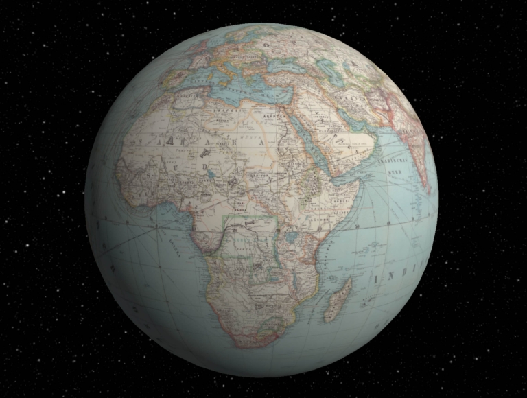
Author
Henze, Adolf
Full Title
Henze's Erd-Globus im Verhältniss wie 1/12,000,000 zur natürlichen Grösse. Druck u. Verlag von Adolf Henze in Neustadt-Leipzig. Gratis-Beilage zum "Illustrirten Anzeiger für Contor und Bureau." Ausgeführt in Henze's karto-typographischer Anstalt Leipzig-Neustadt. (1)
List No
14361.003
Note
First and second globe gores for world map. Map shows political boundaries, cities, railways, roads, ocean routes, major international telegraph lines, population, languages spoken, topography, glaciers, deserts, bodies of water, drainage, coastlines, islands and the date change line. Relief shown with hachures. Includes latitudinal and longitudinal lines. Title cartouche, legend and key appear on eighth sheet. Gores are each 146 x 28, each on a sheet 150 x 31 cm. Gores appear on twelve sheets bound together.
Author
Henze, Adolf
Full Title
Henze's Erd-Globus im Verhältniss wie 1/12,000,000 zur natürlichen Grösse. Druck u. Verlag von Adolf Henze in Neustadt-Leipzig. Gratis-Beilage zum "Illustrirten Anzeiger für Contor und Bureau." Ausgeführt in Henze's karto-typographischer Anstalt Leipzig-Neustadt. (2)
List No
14361.004
Note
Third and fourth globe gores for world map. Map shows political boundaries, cities, railways, roads, ocean routes, major international telegraph lines, population, languages spoken, topography, glaciers, deserts, bodies of water, drainage, coastlines, islands and the date change line. Relief shown with hachures. Includes latitudinal and longitudinal lines. Title cartouche, legend and key appear on eighth sheet. Gores are each 146 x 28, each on a sheet 150 x 31 cm. Gores appear on twelve sheets bound together.
Author
Henze, Adolf
Full Title
Henze's Erd-Globus im Verhältniss wie 1/12,000,000 zur natürlichen Grösse. Druck u. Verlag von Adolf Henze in Neustadt-Leipzig. Gratis-Beilage zum "Illustrirten Anzeiger für Contor und Bureau." Ausgeführt in Henze's karto-typographischer Anstalt Leipzig-Neustadt. (3)
List No
14361.005
Note
Fifth and sixth globe gores for world map. Map shows political boundaries, cities, railways, roads, ocean routes, major international telegraph lines, population, languages spoken, topography, glaciers, deserts, bodies of water, drainage, coastlines, islands and the date change line. Relief shown with hachures. Includes latitudinal and longitudinal lines. Title cartouche, legend and key appear on eighth sheet. Gores are each 146 x 28, each on a sheet 150 x 31 cm. Gores appear on twelve sheets bound together.
Author
Henze, Adolf
Full Title
Henze's Erd-Globus im Verhältniss wie 1/12,000,000 zur natürlichen Grösse. Druck u. Verlag von Adolf Henze in Neustadt-Leipzig. Gratis-Beilage zum "Illustrirten Anzeiger für Contor und Bureau." Ausgeführt in Henze's karto-typographischer Anstalt Leipzig-Neustadt. (4)
List No
14361.006
Note
Seventh and eighth globe gores for world map. Map shows political boundaries, cities, railways, roads, ocean routes, major international telegraph lines, population, languages spoken, topography, glaciers, deserts, bodies of water, drainage, coastlines, islands and the date change line. Relief shown with hachures. Includes latitudinal and longitudinal lines. Title cartouche, legend and key appear on eighth sheet. Gores are each 146 x 28, each on a sheet 150 x 31 cm. Gores appear on twelve sheets bound together.
Author
Henze, Adolf
Full Title
Henze's Erd-Globus im Verhältniss wie 1/12,000,000 zur natürlichen Grösse. Druck u. Verlag von Adolf Henze in Neustadt-Leipzig. Gratis-Beilage zum "Illustrirten Anzeiger für Contor und Bureau." Ausgeführt in Henze's karto-typographischer Anstalt Leipzig-Neustadt. (5)
List No
14361.007
Note
Ninth and tenth globe gores for world map. Map shows political boundaries, cities, railways, roads, ocean routes, major international telegraph lines, population, languages spoken, topography, glaciers, deserts, bodies of water, drainage, coastlines, islands and the date change line. Relief shown with hachures. Includes latitudinal and longitudinal lines. Title cartouche, legend and key appear on eighth sheet. Gores are each 146 x 28, each on a sheet 150 x 31 cm. Gores appear on twelve sheets bound together.
Author
Henze, Adolf
Full Title
Henze's Erd-Globus im Verhältniss wie 1/12,000,000 zur natürlichen Grösse. Druck u. Verlag von Adolf Henze in Neustadt-Leipzig. Gratis-Beilage zum "Illustrirten Anzeiger für Contor und Bureau." Ausgeführt in Henze's karto-typographischer Anstalt Leipzig-Neustadt. (6)
List No
14361.008
Note
Eleventh and twelfth globe gores for world map. Map shows political boundaries, cities, railways, roads, ocean routes, major international telegraph lines, population, languages spoken, topography, glaciers, deserts, bodies of water, drainage, coastlines, islands and the date change line. Relief shown with hachures. Includes latitudinal and longitudinal lines. Title cartouche, legend and key appear on eighth sheet. Gores are each 146 x 28, each on a sheet 150 x 31 cm. Gores appear on twelve sheets bound together.
Author
Henze, Adolf
Full Title
(Composite Map to) Henze's Erd-Globus im Verhältniss wie 1/12,000,000 zur natürlichen Grösse. Druck u. Verlag von Adolf Henze in Neustadt-Leipzig. Gratis-Beilage zum "Illustrirten Anzeiger für Contor und Bureau." Ausgeführt in Henze's karto-typographischer Anstalt Leipzig-Neustadt.
List No
14361.009
Note
World map composed of twelve globe gores. Map shows political boundaries, cities, railways, roads, ocean routes, major international telegraph lines, population, languages spoken, topography, glaciers, deserts, bodies of water, drainage, coastlines, islands and the date change line. Relief shown with hachures. Includes latitudinal and longitudinal lines. Title cartouche, legend and key appear on eighth sheet. Gores are each 146 x 28, each on a sheet 150 x 31 cm. Gores bound together.
Author
Henze, Adolf
Full Title
(Covers to) Handbuch zu Henze's Erd-Globus. Beilage zum Illustrirten Anzeiger für Contor und Bureau. Leipzig-Neustadt. Adolf Henze's Verlag. 1891.
List No
14363.001
Note
Front cover to Handbuch zu Henze's Erd-Globus. Title translates to: Handbook for Henze's Earth Globe ... Includes a world map, centered on Africa. With decorative border. "1. Lieferung" [= First delivery] at top of sheet. Bound in paper.
Author
Henze, Adolf
Full Title
(Text Page to) Vorwort.
List No
14363.002
Note
Foreward to Handbuch zu Henze's Erd-Globus. Text begins: Die ungewöhnliche Grösse unseres "Globus" macht es schwierig, Orts- und andere Namen ohne nähere Bezeichnung aufzufinden [= The unusual size of our "globe" makes it difficult to find place names and other names without further reference].
Author
Henze, Adolf
Full Title
(Composite Text to) Aachen - Golf von Boni, Niederländisch-Indien, Celebes.
List No
14363.003
Note
Composite view of index to Handbuch zu Henze's Erd-Globus. Lists place names, corresponding to globe, in alphabetical order, with longitudinal and latitudinal coordinate points, as well as section numbers. Includes key for abbreviations at bottom of each sheet. Spans 56 pages. (Page number [1] inferred.)
Author
[Pasa, Ali Seref, Esref, Hafiz Ali]
Full Title
Iran : Afganistan; Buhara; Belochistan. 1309 (1891). Tabie ve Nnashiri Hasan Ferid. (to accompany) Yeni cografya atlasi - ىگى جغرافىا آطلسى = New geographical atlas. Dersa'adet (Istanbul), 1307-1309 (1891-1893).
List No
13621.024
Note
Map of Iran, Afghanistan, Pakistan and Uzbekistan.
Author
Ottoman War Ministry Press
Full Title
كريد جزيره سى ختيطه سى [Map of the Island Krete].
List No
10874.000
Note
Dated 1307 [1891].
Author
[Ministere des Travaux Publics, Cheysson, Émile]
Full Title
Tonnage des Voies Navigables en 1889. Repartition du Tonnage ... I. Region du Nord et du Nord-Est. (Breakdown of the tonnage of inland waterways in 1889 by nature of goods: Area of North.)
List No
12521.019
Author
Henze, Adolf
Full Title
Interactive Globe: Henze's Erd-Globus.
List No
10681.027
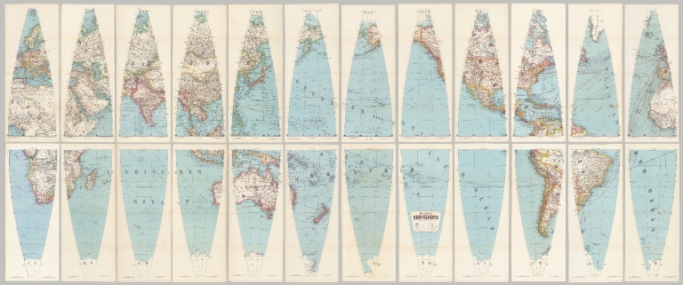
Note
Interactive Globe of georeferenced globe gores. With a diameter of 43 inches, these 24 gores form the largest printed globe produced in the 19th century.Dimensions are sheet size.
Author
Henze, Adolf
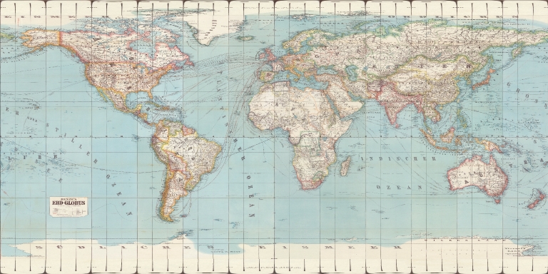
Full Title
Sections 1-24 Henze's Erd-Globus.
List No
10681.026
Note
With a diameter of 43 inches, these 24 gores form the largest printed globe produced in the 19th century. Composite of 24 globe gores. Dimensions are sheet size.
Author
Henze, Adolf
Full Title
Geographic Projection: Sections 1-24 Henze's Erd-Globus.
List No
10681.028
Note
With a diameter of 43 inches, these 24 gores form the largest printed globe produced in the 19th century. Composite of 24 globe gores. Dimensions are sheet size.
Author
Henze, Adolf
Full Title
Robinson Projection: Sections 1-24 Henze's Erd-Globus.
List No
10681.029
Note
With a diameter of 43 inches, these 24 gores form the largest printed globe produced in the 19th century. Composite of 24 globe gores. Dimensions are sheet size.
Author
Henze, Adolf
Full Title
Mollweide Projection: Sections 1-24 Henze's Erd-Globus.
List No
10681.030
Note
With a diameter of 43 inches, these 24 gores form the largest printed globe produced in the 19th century. Composite of 24 globe gores. Dimensions are sheet size.
Author
Henze, Adolf
Full Title
Orthographic Projection: Sections 1-24 Henze's Erd-Globus.
List No
10681.031
Note
With a diameter of 43 inches, these 24 gores form the largest printed globe produced in the 19th century. Composite of 24 globe gores. Dimensions are sheet size.
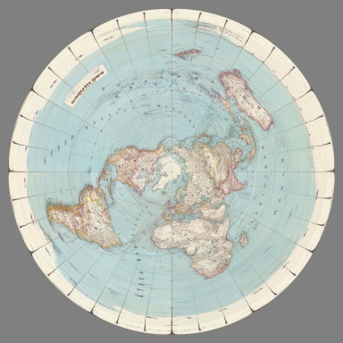
Author
Henze, Adolf
Full Title
Polar Orthographic Projection: Sections 1-24 Henze's Erd-Globus.
List No
10681.032
Note
With a diameter of 43 inches, these 24 gores form the largest printed globe produced in the 19th century. Composite of 24 globe gores. Dimensions are sheet size.
Author
Henze, Adolf
Full Title
Stereographic Projection: Sections 1-24 Henze's Erd-Globus.
List No
10681.033
Note
With a diameter of 43 inches, these 24 gores form the largest printed globe produced in the 19th century. Composite of 24 globe gores. Dimensions are sheet size.
Author
Henze, Adolf
Full Title
Azimuthal Equidistant Projection: Sections 1-24 Henze's Erd-Globus.
List No
10681.034
Note
With a diameter of 43 inches, these 24 gores form the largest printed globe produced in the 19th century. Composite of 24 globe gores. Dimensions are sheet size.
Author
Henze, Adolf
Full Title
Section 1 Henze's Erd-Globus.
List No
10681.001
Note
With a diameter of 43 inches, these 24 gores form the largest printed globe produced in the 19th century.Dimensions are sheet size.
Author
Henze, Adolf
Full Title
Section 2 Henze's Erd-Globus.
List No
10681.002
Note
With a diameter of 43 inches, these 24 gores form the largest printed globe produced in the 19th century.Dimensions are sheet size.
Author
Henze, Adolf
Full Title
Section 3 Henze's Erd-Globus.
List No
10681.003
Note
With a diameter of 43 inches, these 24 gores form the largest printed globe produced in the 19th century.Dimensions are sheet size.
Author
Henze, Adolf
Full Title
Section 4 Henze's Erd-Globus.
List No
10681.004
Note
With a diameter of 43 inches, these 24 gores form the largest printed globe produced in the 19th century.Dimensions are sheet size.
Author
Henze, Adolf
Full Title
Section 5 Henze's Erd-Globus.
List No
10681.005
Note
With a diameter of 43 inches, these 24 gores form the largest printed globe produced in the 19th century.Dimensions are sheet size.
Author
Henze, Adolf
Full Title
Section 6 Henze's Erd-Globus.
List No
10681.006
Note
With a diameter of 43 inches, these 24 gores form the largest printed globe produced in the 19th century.Dimensions are sheet size.
Author
Henze, Adolf
Full Title
Section 7 Henze's Erd-Globus.
List No
10681.007
Note
With a diameter of 43 inches, these 24 gores form the largest printed globe produced in the 19th century.Dimensions are sheet size.
Author
Henze, Adolf
Full Title
Section 8 Henze's Erd-Globus.
List No
10681.008
Note
With a diameter of 43 inches, these 24 gores form the largest printed globe produced in the 19th century.Dimensions are sheet size.
Author
Henze, Adolf
Full Title
Section 9 Henze's Erd-Globus.
List No
10681.009
Note
With a diameter of 43 inches, these 24 gores form the largest printed globe produced in the 19th century.Dimensions are sheet size.
Author
Henze, Adolf
Full Title
Section 10 Henze's Erd-Globus.
List No
10681.010
Note
With a diameter of 43 inches, these 24 gores form the largest printed globe produced in the 19th century.Dimensions are sheet size.
Author
Henze, Adolf
Full Title
Section 11 Henze's Erd-Globus.
List No
10681.011
Note
With a diameter of 43 inches, these 24 gores form the largest printed globe produced in the 19th century.Dimensions are sheet size.
Author
Henze, Adolf
Full Title
Section 12 Henze's Erd-Globus.
List No
10681.012
Note
With a diameter of 43 inches, these 24 gores form the largest printed globe produced in the 19th century.Dimensions are sheet size.
Author
Henze, Adolf
Full Title
Section 13 Henze's Erd-Globus.
List No
10681.013
Note
With a diameter of 43 inches, these 24 gores form the largest printed globe produced in the 19th century.Dimensions are sheet size.
Author
Henze, Adolf
Full Title
Section 14 Henze's Erd-Globus.
List No
10681.014
Note
With a diameter of 43 inches, these 24 gores form the largest printed globe produced in the 19th century.Dimensions are sheet size.
Author
Henze, Adolf
Full Title
Section 15 Henze's Erd-Globus.
List No
10681.015
Note
With a diameter of 43 inches, these 24 gores form the largest printed globe produced in the 19th century.Dimensions are sheet size.
Author
Henze, Adolf
Full Title
Section 16 Henze's Erd-Globus.
List No
10681.016
Note
With a diameter of 43 inches, these 24 gores form the largest printed globe produced in the 19th century.Dimensions are sheet size.
Author
Henze, Adolf
Full Title
Section 17 Henze's Erd-Globus.
List No
10681.017
Note
With a diameter of 43 inches, these 24 gores form the largest printed globe produced in the 19th century.Dimensions are sheet size.
Author
Henze, Adolf
Full Title
Section 18 Henze's Erd-Globus.
List No
10681.018
Note
With a diameter of 43 inches, these 24 gores form the largest printed globe produced in the 19th century.Dimensions are sheet size.
Author
Henze, Adolf
Full Title
Section 19 Henze's Erd-Globus.
List No
10681.019
Note
With a diameter of 43 inches, these 24 gores form the largest printed globe produced in the 19th century.Dimensions are sheet size.
Author
Henze, Adolf
Full Title
Section 22 Henze's Erd-Globus.
List No
10681.020
Note
With a diameter of 43 inches, these 24 gores form the largest printed globe produced in the 19th century.Dimensions are sheet size.
Author
Henze, Adolf
Full Title
Section 20 Henze's Erd-Globus.
List No
10681.021
Note
With a diameter of 43 inches, these 24 gores form the largest printed globe produced in the 19th century.Dimensions are sheet size.
Author
Henze, Adolf
Full Title
Section 23 Henze's Erd-Globus.
List No
10681.022
Note
With a diameter of 43 inches, these 24 gores form the largest printed globe produced in the 19th century.Dimensions are sheet size.
Author
Henze, Adolf
Full Title
Section 21 Henze's Erd-Globus.
List No
10681.023
Note
With a diameter of 43 inches, these 24 gores form the largest printed globe produced in the 19th century.Dimensions are sheet size.
Author
Henze, Adolf
Full Title
Section 24 Henze's Erd-Globus.
List No
10681.024
Note
With a diameter of 43 inches, these 24 gores form the largest printed globe produced in the 19th century.Dimensions are sheet size.
Author
Henze, Adolf
Full Title
Nord und Sud Pole zu Henze's Erd-Globus.
List No
10681.025
Note
With a diameter of 43 inches, these 24 gores form the largest printed globe produced in the 19th century.Dimensions are sheet size.
Author
Henze, Adolf
Full Title
Nord und Sud Pole zu Henze's Erd-Globus.
List No
10681.025
Note
With a diameter of 43 inches, these 24 gores form the largest printed globe produced in the 19th century.Dimensions are sheet size.
Author
[Powell, John Wesley, 1834-1902, United States Geological Survey (USGS), Gannett, Henry, 1846-1914, King, Harry]
Full Title
(Map of the United States. Compiled under the director of Henry Gannett, Chief Topographer, by Harry King, Chief Draughtsman. Department of the Interior, United States Geological Survey, J. W. Powell, Director. 1890. Edition of April 1891. Engraved by Julius Bien & Co. New York. Sheet 7).
List No
14054.008
Note
Sheet 7 of USGS topographic map of the United States, backed with linen and bound with corresponding sheets. This sheet includes part of the southern international border, with Arizona and New Mexico, as well as northwestern Mexico and Baja California. Conveys topography with contour lines, which include elevation figures. Shows state boundaries, cities and towns, railroads, drainage, and national parks, as well as Native American territories and reservations. 40 x 64 cm, on sheet 47 x 69 cm. With inset: Alaska. (Title taken from Sheet 9.)
Author
[Powell, John Wesley, 1834-1902, United States Geological Survey (USGS), Gannett, Henry, 1846-1914, King, Harry]
Full Title
(Map of the United States. Compiled under the director of Henry Gannett, Chief Topographer, by Harry King, Chief Draughtsman. Department of the Interior, United States Geological Survey, J. W. Powell, Director. 1890. Edition of April 1891. Engraved by Julius Bien & Co. New York. Sheet 8).
List No
14054.009
Note
Sheet 8 of USGS topographic map of the United States, backed with linen and bound with corresponding sheets. This sheet includes part of the southern international border, with the south: Texas, Louisiana and Mississippi, as well as northeastern Mexico and the Gulf of Mexico. Conveys topography with contour lines, which include elevation figures. Shows state boundaries, cities and towns, railroads, drainage, and national parks, as well as Native American territories and reservations. 40 x 64 cm, on sheet 47 x 69 cm. (Title taken from Sheet 9.)
Author
[Powell, John Wesley, 1834-1902, United States Geological Survey (USGS), Gannett, Henry, 1846-1914, King, Harry]
Full Title
(Map of the) United States. Compiled under the director of Henry Gannett, Chief Topographer, by Harry King, Chief Draughtsman. Department of the Interior, United States Geological Survey, J. W. Powell, Director. 1890. Edition of April 1891. Engraved by Julius Bien & Co. New York. (Sheet 9).
List No
14054.010
Note
Sheet 9 of USGS topographic map of the United States, backed with linen and bound with corresponding sheets. This sheet includes the south: Alabama, Georgia and Florida. Bar scale and scale statement: Approximately 40 miles to 1 inch. Conveys topography with contour lines, which include elevation figures. Shows state boundaries, cities and towns, railroads, drainage, and national parks, as well as Native American territories and reservations. Descriptive text beneath title, including citations and an explanation of contour lines. Handwritten annotations, in pencil, including "Map of the" preceding the title, United States. Map originally published in 1890; this edition 1891. 40 x 64 cm, on sheet 47 x 69 cm.
Author
[Powell, John Wesley, 1834-1902, United States Geological Survey (USGS), Gannett, Henry, 1846-1914, King, Harry]
Full Title
(Composite to) (Map of the) United States. Compiled under the director of Henry Gannett, Chief Topographer, by Harry King, Chief Draughtsman. Department of the Interior, United States Geological Survey, J. W. Powell, Director. 1890. Edition of April 1891. Engraved by Julius Bien & Co. New York. (Sheet 9).
List No
14054.011
Note
Composite to 9-sheet USGS topographic map of the United States. Conveys topography with contour lines, which include elevation figures. Shows state boundaries, cities and towns, railroads, drainage, and national parks, as well as Native American territories and reservations. Title, statement of responsibility, and descriptive text at lower right. Map originally published in 1890; this edition 1891.
Author
[Lopez, Genaro, Mexico. Museo Nacional de Historia Natural]
Full Title
(Composite Map) Plano de las ruinas de Cempoala : levantado por orden de la Sria. de Justicia e Instruccien publica, por los oficiales de ingenieros Capitan 2o. P.P. Romero y Teniene F. del Castillo ; con la coopercion del director del Museo Nacional: Sr. D. Francisco del Paso y Croncoso. 1891. Genaro Lopez litografio. Lit. del Timbre Imprimio.
List No
13023.003
Note
1 map on 2 sheets, 91x57.5. Showing the archaeological site of Cempoala in central Mexico, along the Actopan River. Includes an explanation of the various sites By Genaro Lopez by order of the Sria. of Justice and Public Instruction, with the cooperation of the director of the National Museum: Mr. D. Francisco del Paso and Croncoso. 1891. Relief shown by hachures. Includes explanation.
Author
Rand, McNally & Co.
Full Title
Philadelphia.
List No
9733.049
Author
Stanford, Edward
Full Title
(Composite with Index Map and Legend) Stanford's Library Map of London and Its Suburbs. 24 Sheets. On the Scale of Six Inches to a Mile. London: Edward Stanford, 55, Charing Cross, S.W.
List No
12247.001
Note
Composite of labels on the backs of six map sheets.
Author
Stanford, Edward
Full Title
(Composite Map) (Stanford's Library Map of London and Its Suburbs.)
List No
12247.007
Note
Merging inner borders of the four maps.
Author
[Booth, Charles, 1840-1916, Edward Stanford Ltd.]
Full Title
(Composite map) Descriptive map of London poverty 1889. (to accompany) Labour and life of the people. Appendix to volume II. Edited by Charles Booth. William and Norgate, London; Edinburgh. 1891.
List No
11486.010
Note
Composite of map 2, sheets 1-4. 4 color maps of London poverty 1889. Shows names of cities, ward and county boundaries, drainage, building, landmarks, roads and railroads. Note: "The East London part of this map was prepared in 1887, & Published in volume 1." Includes color coded streets:"The streets are colured according to the general condition of the inhabitants."
Author
[Ordnance Survey Office, Geikie, Archibald]
Full Title
(Composite of) Sheets 2 - 15. Ordnance Survey of England and Wales.
List No
8742.017
Author
Amerine, C.H.
Full Title
C.H. Amerine's : Sectional map of Washington, Oregon, Idaho, and western Montana. Compiled from latest official data exploration and other sources. Compiled and published by C.H. Amerine, 1891. Copyrighted by C.H. Amerine, Tacoma, Wash. Photo - Litho by Schmidt Lable & Lith Co. S.F.
List No
6744.000
Note
Amerine published several maps of Washington, Oregon, Puget Sound and other areas of the Pacific Northwest, but this is his only multi-state map that we know of and it is not held in any libraries listed in WorldCat. Full color map, backed with linen. Shows capitals, county, towns, wagon roads, railroads, trails, reservations, light houses, blocks, subdivisions, etc. Includes explanation and table of township subdivision. Relief shown by hachures. Prime meridian is Washington.
Author
[Walker, G.H., Walker, O.W.]
Full Title
(Composite Map) (Massachusetts).
List No
2006.065
Author
Imray, James and Son
Full Title
Coast of Labrador From the Strait of Belle Isle to Port Manvers...Corrected to 1891.
List No
4149.000
Note
Dissected chart with many ms notes on "Route marked by A. Kean, Master S.S. Curlew."
Author
Rand McNally and Company
Full Title
(Composite Map of) Rand, McNally & Co.'s New Shippers' Railroad Map of the United States. Scale: 8 miles to one inch. Showing all railroads, each in a separate color, and all railroad stations in large, plain type. This is the El Paso section only, of the above named map. (Below the neatline) Rand, McNally & Co.'s New Shippers' Railroad Map of the United States, Copyright, 1888 by Rand, McNally & Co. Copyright, 1891 by Rand, McNally & Co.
List No
5802.017
Note
This is a composite of all 13 maps. The owner of the 13 maps did not include the 2 western maps in this group for some reason, roughly Dakota and Indian Territory, or they may have been lost over time. Each set of these maps was made to order custom by Rand McNally so it is possible that these 13 maps comprise the entire set. The other 2 maps of the western US to the pacific are in the set but they are at a smaller scale so they are not in this composite image.
Author
American Telephone and Telegraph Company
Full Title
(Covers to) Lines and Metallic Circuit Connections. American Telephone and Telegraph Co. 18 Cortlandt St. New York. March 1, 1891.
List No
5564A
Author
American Telephone and Telegraph Company
Full Title
Lines and Metallic Circuit Connections. American Telephone and Telegraph Co. 18 Cortlandt St. New York. March 1, 1891.
List No
5564.001
Note
The map shows the communication lines in orange. On the folded cover is the statement "500 miles and return in 5 minutes. The mail is quick; telegraph is quicker; but Long Distance Telephone is Instantaneous and you don't have to wait for an answer." On the back of the map is a list of public pay stations. Folding into self wrappers 20x9.5, with "New York, Boston, Buffalo, Washington. Local and Long Distance Telephone. American Telephone and Telegraph Company. General Offices, 18 Cortlandt St. New-York. John C. Rankin Co., 34 Cortlandt St. N.Y."
Author
[Garside, G.W., Alaskan Boundary Tribunal]
Full Title
(Facsimile) Map of Pyramid Harbor & Vicinity, on Chilkat Inlet, Lynn Canal, Alaska, 1891. Surveyed by G.W. Garside, U.S. Deputy Surveyor for Alaska, Oct. 1891. Drawn by R.F. Morton, C.E., San Francisco. Alaskan Boundary Tribunal, 1903. 29. Andrew B. Graham. Photo-Litho. Washington.D.C.
List No
0009.075
Author
Appleton, D. & Co.
Full Title
United States. Copyright 1891 by Matthews-Northrup Co. Complete engineering and printing works, Buffalo and New York. (inset) Alaska. (to accompany) The Library Atlas Of Modern Geography ... New York, D. Appleton And Company 1892. (on upper margin) United States 11.
List No
0026.018
Note
Color map on 2 sheets. Shows states, territories, major cities, rivers, mountains, roads, railways. Includes " Divisional maps". Relief shown by hachures. Prime meridians are Washington and Greenwich.
Author
Appleton, D. & Co.
Full Title
Dominion of Canada. Copyright 1891 by Appleton & Co. (inset) Vancouver Island. (to accompany) The Library Atlas Of Modern Geography ... New York, D. Appleton And Company 1892. (on upper margin) Canada 12.
List No
0026.019
Note
Color map on 2 sheets. Shows states, territories, major cities, rivers, mountains, roads, railways, principal steam routes and distances from place to place. Includes " Divisional maps". Relief shown by hachures and spot heights. Prime meridian is Greenwich.
Author
Appleton, D. & Co.
Full Title
British Isles. Copyright 1891 by Appleton & Co.(to accompany) The Library Atlas Of Modern Geography ... New York, D. Appleton And Company 1892. (on upper margin) British Isles 13.
List No
0026.020
Note
Color map on 2 sheets. Shows political and administrative divisions, major cities, rivers, mountains, roads, railways, principal steam routes and distances from place to place. Includes " Divisional maps". Relief shown by hachures. Prime meridian is Greenwich.
Author
Appleton, D. & Co.
Full Title
(Text Page to) British Isles. .(to accompany) The Library Atlas Of Modern Geography ... New York, D. Appleton And Company 1892. (on upper margin) Map No. 13.
List No
0026.023
Note
Descriptive text on 2 pages, with engraved, uncolored view of Eton, interior of the Quadrangle. Includes geographical, historical, resources and productions, financial and commercial, educational and religious, governmental, and cities.
Author
Appleton, D. & Co.
Full Title
Scotland. Copyright 1891 by Appleton & Co. (untitled insets) Glasgow; Edinburgh. (to accompany) The Library Atlas Of Modern Geography ... New York, D. Appleton And Company 1892. (on upper margin) Scotland 15.
List No
0026.025
Note
Color map on 2 sheets, with 2 insets. Shows administrative divisions, major cities, rivers, mountains, roads, railways, canals, battle fields, principal steam routes and distances from place to place. Relief shown by hachures. Spot heights in feet. Prime meridian is Greenwich.
Author
Appleton, D. & Co.
Full Title
(Text Page to) Scotland. (to accompany) The Library Atlas Of Modern Geography ... New York, D. Appleton And Company 1892. (on upper margin) Map No. 15.
List No
0026.026
Note
Descriptive text, with engraved, uncolored view of Edinburgh, from Nelson's Monument. Includes geographical, historical, governmental, resources and productions, financial and commercial, educational and religion information.
Author
Appleton, D. & Co.
Full Title
(Text Page to) Scotland. (to accompany) The Library Atlas Of Modern Geography ... New York, D. Appleton And Company 1892. (on upper margin) Map No. 15.
List No
0026.027
Note
Descriptive text, with engraved, uncolored view of Edinburgh, from Nelson's Monument. Includes geographical, historical, governmental, resources and productions, financial and commercial, educational and religion information.
Author
Appleton, D. & Co.
Full Title
Ireland. Copyright 1891 by Appleton & Co. (untitled insets) Belfast; Dublin. (to accompany) The Library Atlas Of Modern Geography ... New York, D. Appleton And Company 1892. (on upper margin) Ireland 16.
List No
0026.028
Note
Color map on 2 sheets, with 2 insets. Shows administrative divisions, major cities, rivers, mountains, roads, railways, canals, battle fields, principal steam routes and distances from place to place. Relief shown by hachures. Spot heights in feet. Prime meridian is Greenwich.
Author
Appleton, D. & Co.
Full Title
(Text Page to) Ireland. (to accompany) The Library Atlas Of Modern Geography ... New York, D. Appleton And Company 1892. (on upper margin) Map No. 16.
List No
0026.029
Note
Descriptive text, with engraved, uncolored view of Limerick. Includes geographical, historical, governmental, resources and productions, financial and commercial, inhabitants, educational and religion information.
Author
Appleton, D. & Co.
Full Title
Holland and Belgium. Copyright 1891 by Appleton & Co. (insets) Amsterdam; Environs of Brussels; Antwerp. (to accompany) The Library Atlas Of Modern Geography ... New York, D. Appleton And Company 1892. (on upper margin) Holland & Belgium 18.
List No
0026.033
Note
Color map on 2 sheets. Shows administrative divisions, major cities, roads, railways, canals, battle fields, forts and fortifications, lighthouses, principal steam routes and distances from place to place. Prime meridian is Greenwich.
Author
Appleton, D. & Co.
Full Title
(Text Page to) Holland. (to accompany) The Library Atlas Of Modern Geography ... New York, D. Appleton And Company 1892. (on upper margin) Map No. 18.
List No
0026.034
Note
Descriptive text, with engraved, uncolored view of Amsterdam. Includes geographical, historical, governmental, resources and productions, financial and commercial, colonial possessions, educational and religion information, and text on Amsterdam.
Author
Appleton, D. & Co.
Full Title
(Text Page to) Holland. (to accompany) The Library Atlas Of Modern Geography ... New York, D. Appleton And Company 1892. (on upper margin) Map No. 18.
List No
0026.035
Note
Descriptive text, with engraved, uncolored view of Amsterdam. Includes geographical, historical, governmental, resources and productions, financial and commercial, colonial possessions, educational and religion information, and text on Amsterdam.
Author
Appleton, D. & Co.
Full Title
(Text Page to) Belgium. (to accompany) The Library Atlas Of Modern Geography ... New York, D. Appleton And Company 1892. (on upper margin) Map No. 18.
List No
0026.036
Note
Descriptive text, with engraved, uncolored view of Antwerp- the Tower Hall and Schelde. Includes geographical, historical, governmental, resources and productions, financial and commercial, colonial possessions, educational and religion information, and text on Brussels and Luxembourg.
Author
Appleton, D. & Co.
Full Title
(Text Page to) Belgium. (to accompany) The Library Atlas Of Modern Geography ... New York, D. Appleton And Company 1892. (on upper margin) Map No. 18.
List No
0026.037
Note
Descriptive text, with engraved, uncolored view of Antwerp- the Tower Hall and Schelde. Includes geographical, historical, governmental, resources and productions, financial and commercial, colonial possessions, educational and religion information, and text on Brussels and Luxembourg.
Author
Appleton, D. & Co.
Full Title
Spain and Portugal. Copyright 1891 by Appleton & Co. (insets) Gibraltar; Lisbon; Madrid. (to accompany) The Library Atlas Of Modern Geography ... New York, D. Appleton And Company 1892. (on upper margin) Spain & Portugal 20.
List No
0026.041
Note
Color map on 2 sheets. Shows administrative divisions, major cities, roads, railways, canals, battle fields, forts and fortifications, submarine cables, principal steam routes and distances from place to place, etc. Relief shown by hachures. Heights in English feet. Note: "The names of the chief towns and new provinces of Portugal are underlined".
Author
Appleton, D. & Co.
Full Title
(Text Page to) Spain. (to accompany) The Library Atlas Of Modern Geography ... New York, D. Appleton And Company 1892. (on upper margin) Map No. 20.
List No
0026.042
Note
Descriptive text, with engraved, uncolored view of Barcelona. Includes geographical, historical, governmental, agricultural, resources and productions, financial and commercial, colonial possessions, educational and religion information, and text on Madrid, Gibraltar and Andorra.
Author
Appleton, D. & Co.
Full Title
(Text Page to) Spain. (to accompany) The Library Atlas Of Modern Geography ... New York, D. Appleton And Company 1892. (on upper margin) Map No. 20.
List No
0026.043
Note
Descriptive text, with engraved, uncolored view of Barcelona. Includes geographical, historical, governmental, agricultural, resources and productions, financial and commercial, colonial possessions, educational and religion information, and text on Madrid, Gibraltar and Andorra.
Author
Appleton, D. & Co.
Full Title
(Text Page to) Portugal. (to accompany) The Library Atlas Of Modern Geography ... New York, D. Appleton And Company 1892. (on upper margin) Map No. 20.
List No
0026.044
Note
Descriptive text, with engraved, uncolored view of Oporto. Includes geographical, historical, governmental, agricultural, resources and productions, financial and commercial, educational and religion information, and text on Lisbon.
Author
Appleton, D. & Co.
Full Title
(Text Page to) Portugal. (to accompany) The Library Atlas Of Modern Geography ... New York, D. Appleton And Company 1892. (on upper margin) Map No. 20.
List No
0026.045
Note
Descriptive text, with engraved, uncolored view of Oporto. Includes geographical, historical, governmental, agricultural, resources and productions, financial and commercial, educational and religion information, and text on Lisbon.
Author
Appleton, D. & Co.
Full Title
Russia. Copyright 1891 by Appleton & Co. (untitled insets) Odessa; St. Petersburg; Moscow. (to accompany) The Library Atlas Of Modern Geography ... New York, D. Appleton And Company 1892. (on upper margin) Russia 25.
List No
0026.057
Note
Color map on 2 sheets. Shows administrative divisions, major cities, roads, railways, canals, forts and fortifications, submarine cables, principal steam routes and distances from place to place, etc. Includes reference. Relief shown by hachures and spot heights in feet. Prime meridian is Greenwich.
Author
Appleton, D. & Co.
Full Title
(Text Page to) Russia. (to accompany) The Library Atlas Of Modern Geography ... New York, D. Appleton And Company 1892. (on upper margin) Map No. 25.
List No
0026.058
Note
Descriptive text, with engraved, uncolored view of St. Petersburg. Includes geographical, historical, governmental, resources and productions, financial and commercial, and educational information, and text on St. Petersburg.
Author
Appleton, D. & Co.
Full Title
(Text Page to) Russia. (to accompany) The Library Atlas Of Modern Geography ... New York, D. Appleton And Company 1892. (on upper margin) Map No. 25.
List No
0026.059
Note
Descriptive text, with engraved, uncolored view of St. Petersburg. Includes geographical, historical, governmental, resources and productions, financial and commercial, and educational information, and text on St. Petersburg.
Author
Appleton, D. & Co.
Full Title
Austria - Hungary. Copyright 1891 by Appleton & Co. (insets) Environs of Budapest; Triest; Prague; Vienna. (to accompany) The Library Atlas Of Modern Geography ... New York, D. Appleton And Company 1892. (on upper margin) Austria 25.
List No
0026.060
Note
Color map on 2 sheets. Shows administrative divisions, major cities, roads, railways, canals, forts and fortifications, principal steam routes and distances from place to place, battle fields, forts and fortification, etc. Includes reference. Relief shown by hachures and spot heights in feet. Prime meridian is Greenwich.
Author
Appleton, D. & Co.
Full Title
(Text Page to) Austria - Hungary. (to accompany) The Library Atlas Of Modern Geography ... New York, D. Appleton And Company 1892. (on upper margin) Map No. 26.
List No
0026.061
Note
Descriptive text, with engraved, uncolored view of Vienna - The Graben. Includes geographical, historical, governmental, resources and productions, financial and commercial, educational, inhabitants, religion information, and text on Vienna, Prague, and Budapest.
Author
Appleton, D. & Co.
Full Title
(Text Page to) Austria - Hungary. (to accompany) The Library Atlas Of Modern Geography ... New York, D. Appleton And Company 1892. (on upper margin) Map No. 26.
List No
0026.062
Note
Descriptive text, with engraved, uncolored view of Vienna- The Graben. Includes geographical, historical, governmental, resources and productions, financial and commercial, educational, inhabitants, religion information, and text on Vienna, Prague, and Budapest.
Author
Appleton, D. & Co.
Full Title
Turkey in Europe : Ramania, Servia, Montenegro & Greece. Copyright 1891 by Appleton & Co. (insets) Enlarged plan of Bosporus; Constantinople; Dardanelles; Athens. (to accompany) The Library Atlas Of Modern Geography ... New York, D. Appleton And Company 1892. (on upper margin) Turkey & Greece 27.
List No
0026.063
Note
Color map on 2 sheets. Shows administrative divisions, major cities, roads, railways, forts and fortifications, principal steam routes and distances from place to place, battle fields, etc. Includes reference. Relief shown by hachures and spot heights in feet. Prime meridian is Greenwich.
Author
Appleton, D. & Co.
Full Title
(Text Page to) Turkey. (to accompany) The Library Atlas Of Modern Geography ... New York, D. Appleton And Company 1892. (on upper margin) Map No. 27 and 30.
List No
0026.064
Note
Descriptive text, with engraved, uncolored view of Constaninople and Golden Horn- The Graben. Includes geographical, historical, governmental, resources and productions, financial and commercial, educational, inhabitants, religion information, and text on Constaninope.
Author
Appleton, D. & Co.
Full Title
(Text Page to) Romania. Montenegro. (to accompany) The Library Atlas Of Modern Geography ... New York, D. Appleton And Company 1892. (on upper margin) Map No. 27 and 30.
List No
0026.065
Note
Descriptive text on 2 pages, with engraved, uncolored view of Constaninople and Golden Horn- The Graben, and The Bosporus. Includes geographical, historical, governmental, resources and productions, financial and commercial, educational, inhabitants, religion information, and text on Constaninope, and Bucharest.
Author
Appleton, D. & Co.
Full Title
(Text Page to) Bulgaria. Servia. Greece. (to accompany) The Library Atlas Of Modern Geography ... New York, D. Appleton And Company 1892. (on upper margin) Map No. 27 and 30. Balkan States. Greece.
List No
0026.066
Note
Descriptive text on 2 pages, with engraved, uncolored view of Temple of Theseus and Acropolis. Includes geographical, historical, governmental, resources and productions, financial and commercial, educational, inhabitants, religion information, and text on Sofia, Belgrade, and Athens.
Author
Appleton, D. & Co.
Full Title
(Text Page to) Bulgaria. Servia. Greece. (to accompany) The Library Atlas Of Modern Geography ... New York, D. Appleton And Company 1892. (on upper margin) Map No. 27 and 30. Greece.
List No
0026.067
Note
Descriptive text on 2 pages, with engraved, uncolored view of Temple of Theseus and Acropolis. Includes geographical, historical, governmental, resources and productions, financial and commercial, educational, inhabitants, religion information, and text on Sofia, Belgrade, and Athens.
Author
Appleton, D. & Co.
Full Title
Italy. Copyright 1891 by Appleton & Co. (to accompany) The Library Atlas Of Modern Geography ... New York, D. Appleton And Company 1892. (with 5 insets). (on upper margin) Italy, 28.
List No
0026.068
Note
Color map on 2 sheets. Insets: Venice; Naples; Rome; Palermo; Strait of Messina. Shows administrative divisions, major cities, roads, railways, canals, forts and fortifications, principal steam routes and distances from place to place, battle fields, etc. Includes reference. Relief shown by hachures and spot heights in feet. Prime meridian is Greenwich.
Author
Appleton, D. & Co.
Full Title
(Text Page to) Italy. (to accompany) The Library Atlas Of Modern Geography ... New York, D. Appleton And Company 1892. (on upper margin) Map No. 28.
List No
0026.069
Note
Descriptive text on 2 pages, with engraved, uncolored view of Naples. Includes geographical, historical, governmental, resources and productions, financial and commercial, educational, inhabitants, religion information, colonial, and text on Rome.
Author
Appleton, D. & Co.
Full Title
(Text Page to) Italy. (to accompany) The Library Atlas Of Modern Geography ... New York, D. Appleton And Company 1892. (on upper margin) Map No. 28.
List No
0026.070
Note
Descriptive text on 2 pages, with engraved, uncolored view of Naples. Includes geographical, historical, governmental, resources and productions, financial and commercial, educational, inhabitants, religion information, colonial, and text on Rome.
Author
Appleton, D. & Co.
Full Title
Sketch map of the Mediterranean and adjacent countries. Copyright 1891 by Appleton & Co. (to accompany) The Library Atlas Of Modern Geography ... New York, D. Appleton And Company 1892. (with 6 insets). (on upper margin) Mediterranean, 29.
List No
0026.071
Note
Color map on 2 sheets. Insets: Marseilles; Gibraltar; Alexandria; Valetta Harbours; The Maltese Islands; Cyprus. Shows political boundaries, administrative divisions, major cities, roads, canals, principal steam routes and distances from place to place, etc. Relief shown by hachures. Prime meridian is Greenwich.
Author
Appleton, D. & Co.
Full Title
Turkey in Asia. Copyright 1891 by Appleton & Co. (inset) Smyrna. (to accompany) The Library Atlas Of Modern Geography ... New York, D. Appleton And Company 1892. (on upper margin) Turkey in Asia, 30.
List No
0026.072
Note
Color map on 2 sheets. Shows political boundaries, administrative divisions, capitals, railroads, roads, canals, principal steam routes and distances from place to place, forts and fortifications, etc. Relief shown by hachures and spot heights. Prime meridian is Greenwich.
Author
Appleton, D. & Co.
Full Title
(Text Page to) Asia. (to accompany) The Library Atlas Of Modern Geography ... New York, D. Appleton And Company 1892. (on upper margin) Map No. 30.
List No
0026.073
Note
Descriptive text, with engraved, uncolored view of Cotton market, Bombay and Srinagar - Bridge over the Jhilam. Includes geographical, historical, inhabitants, political and population, etc.
Author
Appleton, D. & Co.
Full Title
(Text Page to) Asia. (to accompany) The Library Atlas Of Modern Geography ... New York, D. Appleton And Company 1892. (on upper margin) Map No. 30.
List No
0026.074
Note
Descriptive text, with engraved, uncolored view of Cotton market, Bombay and Srinagar - Bridge over the Jhilam. Includes geographical, historical, inhabitants, political and population, etc.
Author
Appleton, D. & Co.
Full Title
Palestine. Copyright 1891 by Appleton & Co. (insets) Jerusalem; Plan of Jerusalem. (to accompany) The Library Atlas Of Modern Geography ... New York, D. Appleton And Company 1892. (on upper margin) Palestine, 31.
List No
0026.075
Note
Color map on 2 sheets. Shows political boundaries, administrative divisions, capitals, roads, caravan routes, canals, principal steam routes and distances from place to place, forts and fortifications, etc. Inset showing detail plan of major buildings in Jerusalem. Includes explanation of Arabic words. Relief shown by hachures and spot heights. Prime meridian is Greenwich.
Author
Appleton, D. & Co.
Full Title
(Text Page to) Palestine. (to accompany) The Library Atlas Of Modern Geography ... New York, D. Appleton And Company 1892. (on upper margin) Map No. 31.
List No
0026.076
Note
Descriptive text, with engraved, uncolored view of Jerusalem. Includes geographical, historical,resources and productions, agricultural, etc., and text on Jerusalem.
Author
Appleton, D. & Co.
Full Title
(Text Page to) Palestine. (to accompany) The Library Atlas Of Modern Geography ... New York, D. Appleton And Company 1892. (on upper margin) Map No. 31.
List No
0026.077
Note
Descriptive text, with engraved, uncolored view of Jerusalem. Includes geographical, historical,resources and productions, agricultural, etc., and text on Jerusalem.
Author
Appleton, D. & Co.
Full Title
Arabia. Copyright 1891 by Appleton & Co. (inset) Strait of Bab-El-Mandeb. (to accompany) The Library Atlas Of Modern Geography ... New York, D. Appleton And Company 1892. (on upper margin) Arabia, 32.
List No
0026.078
Note
Color map on 2 sheets. Shows administrative divisions, railways, canals, principal steam routes and distances from place to place, forts and fortifications, etc. Relief shown by hachures and spot heights. Prime meridian is Greenwich.
Author
Appleton, D. & Co.
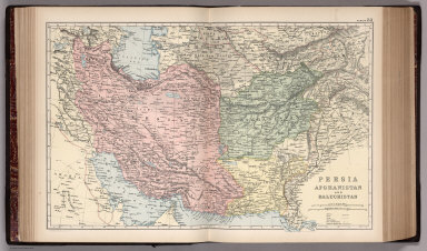
Full Title
Persia, Afshanistan and Baluchistan. Copyright 1891 by Appleton & Co. (to accompany) The Library Atlas Of Modern Geography ... New York, D. Appleton And Company 1892. (on upper margin) Persia, 33.
List No
0026.079
Note
Color map on 2 sheets. Shows political and administrative divisions, railways, roads, canals, principal steam routes and distances from place to place, forts and fortifications, etc. Relief shown by hachures and spot heights. Prime meridian is Greenwich.
Author
Appleton, D. & Co.
Full Title
(Text Page to) Persia. (to accompany) The Library Atlas Of Modern Geography ... New York, D. Appleton And Company 1892. (on upper margin) Map No. 33.
List No
0026.080
Note
Descriptive text, with engraved, uncolored view of Tehran and The Kabul River. Includes geographical, historical, governmental, inhabitants, education and religion, financial and commercial, and text on Tehran.
Author
Appleton, D. & Co.
Full Title
(Text Page to) Persia. Afghanistan. (to accompany) The Library Atlas Of Modern Geography ... New York, D. Appleton And Company 1892. (on upper margin) Map No. 33.
List No
0026.081
Note
Descriptive text, with engraved, uncolored view of Tehran and The Kabul River. Includes geographical, historical, governmental, inhabitants, education and religion, financial and commercial, and text on Tehran.
Author
Appleton, D. & Co.
Full Title
(Text Page to) India. (to accompany) The Library Atlas Of Modern Geography ... New York, D. Appleton And Company 1892. (on upper margin) Map No. 34.
List No
0026.083
Note
Descriptive text on India and Ceylon, with engraved, uncolored view of Benares - View taken from the Gahts. Includes geographical, historical, governmental, inhabitants, education, population, financial and commercial information.
Author
Appleton, D. & Co.
Full Title
(Text Page to) India. (to accompany) The Library Atlas Of Modern Geography ... New York, D. Appleton And Company 1892. (on upper margin) Map No. 34.
List No
0026.084
Note
Descriptive text on India and Ceylon, with engraved, uncolored view of Benares - View taken from the Gahts. Includes geographical, historical, governmental, inhabitants, education, population, financial and commercial information.
Author
Appleton, D. & Co.
Full Title
China. Copyright 1891 by Appleton & Co. (with 3 insets) Environs of Hong Kong, Macao & Canton; Peking; Shanghai. (to accompany) The Library Atlas Of Modern Geography ... New York, D. Appleton And Company 1892. (on upper margin) China 35.
List No
0026.085
Note
Color map on 2 sheets. Shows administrative divisions, railways, roads, principal steam routes and distances from place to place, etc. Relief shown by hachures.
Author
Appleton, D. & Co.
Full Title
(Text Page to) China. (to accompany) The Library Atlas Of Modern Geography ... New York, D. Appleton And Company 1892. (on upper margin) Map No. 35.
List No
0026.086
Note
Descriptive text, with engraved, uncolored view of The High Street and Temple of Heaven, Peking. Includes geographical, historical, governmental,resources and productions, financial and commercial, educational and religion information.
Author
Appleton, D. & Co.
Full Title
(Text Page to) China. (to accompany) The Library Atlas Of Modern Geography ... New York, D. Appleton And Company 1892. (on upper margin) Map No. 35.
List No
0026.087
Note
Descriptive text, with engraved, uncolored view of The High Street and Temple of Heaven, Peking. Includes geographical, historical, governmental,resources and productions, financial and commercial, educational and religion information, with text on Hong Kong and Cora (Korea).
Author
Appleton, D. & Co.
Full Title
East India Islands with parts of lower Burma, Siam & Anam. Copyright 1891 by Appleton & Co. (insets) Singapur; Batavia. (to accompany) The Library Atlas Of Modern Geography ... New York, D. Appleton And Company 1892. (on upper margin) East Indies 37.
List No
0026.090
Note
Color map on 2 sheets. Shows railways, principal steam routes and distances from place to place, submarine telegraph lines, etc. Includes color coded European possession in East Indies. Relief shown by hachures and spot heights. Prime meridian is Greenwich.
Author
Appleton, D. & Co.
Full Title
(Text Page to) The Straits settlements. (to accompany) The Library Atlas Of Modern Geography ... New York, D. Appleton And Company 1892. (on upper margin) Map No. 37.
List No
0026.091
Note
Descriptive text, with engraved uncolored view of the River Amandit, Dutch Borneo. Covers Malay Peninsula, Singapore, Penang (Malaysia), Malaca, and Borneo (Indonesia).
Author
Appleton, D. & Co.
Full Title
Egypt. Copyright 1891 by Appleton & Co. (insets) The Nile Delta and Suez Canal. Cairo. (to accompany) The Library Atlas Of Modern Geography ... New York, D. Appleton And Company 1892. (on upper margin) Egypt. 38.
List No
0026.092
Note
Color map on 2 sheets. Shows railways, principal steam routes and distances from place to place, submarine cables, fort and fortifications, etc. Relief shown by hachures and spot heights. Prime meridian is Greenwich.
Author
Appleton, D. & Co.
Full Title
(Text Page to) Egypt. (to accompany) The Library Atlas Of Modern Geography ... New York, D. Appleton And Company 1892. (on upper margin) Map No. 38.
List No
0026.093
Note
Descriptive text, with engraved uncolored view of Citadel of Cairo. Includes geographical, historical, governmental,resources and productions, educational and religion information, with text on Cairo.
Author
Appleton, D. & Co.
Full Title
(Text Page to) Egypt. (to accompany) The Library Atlas Of Modern Geography ... New York, D. Appleton And Company 1892. (on upper margin) Map No. 38.
List No
0026.094
Note
Descriptive text, with engraved uncolored view of Citadel of Cairo. Includes geographical, historical, governmental, resources and productions, educational and religion information, with text on Cairo.
Author
Appleton, D. & Co.
Full Title
Mexico. Copyright 1891 by Appleton & Co. (inset) Mexico City. (to accompany) The Library Atlas Of Modern Geography ... New York, D. Appleton And Company 1892. (on upper margin) Mexico. 41.
List No
0026.099
Note
Color map on 2 sheets. Shows major cities and towns, railways, roads, battle fields, principal steam routes and distances from place to place, submarine cables, etc. Relief shown by hachures and spot heights. Prime meridian is Greenwich.
Author
Appleton, D. & Co.
Full Title
(Text Page to) North America. (to accompany) The Library Atlas Of Modern Geography ... New York, D. Appleton And Company 1892. (on upper margin) Map No. 41.
List No
0026.100
Note
Descriptive text, with uncolored view of The Yellowstone. Includes geographical, historical, resources and productions, zoological, and political information.
Author
Appleton, D. & Co.
Full Title
(Text Page to) North America. (to accompany) The Library Atlas Of Modern Geography ... New York, D. Appleton And Company 1892. (on upper margin) Map No. 41.
List No
0026.101
Note
Descriptive text, with uncolored view of The Yellowstone. Includes geographical, historical, resources and productions, zoological, and political information.
Author
Appleton, D. & Co.
Full Title
(Text Page to) Mexico. (to accompany) The Library Atlas Of Modern Geography ... New York, D. Appleton And Company 1892. (on upper margin) Map No. 41.
List No
0026.102
Note
Descriptive text, with uncolored view of Vela Cruz and Fort of San Juan Ulloa. Includes geographical, historical, governmental, resources and productions,educational information, and text on City of Mexico.
Author
Appleton, D. & Co.
Full Title
(Text Page to) Mexico. (to accompany) The Library Atlas Of Modern Geography ... New York, D. Appleton And Company 1892. (on upper margin) Map No. 41.
List No
0026.103
Note
Descriptive text, with uncolored view of Vela Cruz and Fort of San Juan Ulloa. Includes geographical, historical, governmental, resources and productions,educational information, and text on City of Mexico.
Author
Appleton, D. & Co.
Full Title
Australia. Copyright 1891 by D. Appleton & Co. (with 4 insets). (to accompany) The Library Atlas Of Modern Geography ... New York, D. Appleton And Company 1892. (on upper margin) Australia 47.
List No
0026.120
Note
Color map on 2 sheets. Insets: Plan of Melbourne & suburbs, Adelaide, Sydney, and Tasmania. Shows major cities and towns, canals, railways, roads, submarine cables, principal steam routes and distances from place to place, etc. Relief shown by hachures and spot heights. Prime meridian is Greenwich.
Author
Appleton, D. & Co.
Full Title
(Text Page to) Oceanica. (to accompany) The Library Atlas Of Modern Geography ... New York, D. Appleton And Company 1892. (on upper margin) Map No. 47.
List No
0026.121
Note
Descriptive text, with uncolored view of Harbour of Manilla (Philippine Islands).
Author
Appleton, D. & Co.
Full Title
(Text Page to) Australia. (to accompany) The Library Atlas Of Modern Geography ... New York, D. Appleton And Company 1892. (on upper margin) Map No. 47.
List No
0026.122
Note
Descriptive text, with uncolored view of Blue Mountains, Australia. Includes geographical, historical, governmental, resources and productions, animals, inhabitants,and educational information, list of cities and towns, and text on Tasmania.
Author
Appleton, D. & Co.
Full Title
(Text Page to) Australia. (to accompany) The Library Atlas Of Modern Geography ... New York, D. Appleton And Company 1892. (on upper margin) Map No. 47.
List No
0026.123
Note
Descriptive text, with uncolored view of Blue Mountains, Australia. Includes geographical, historical, governmental, resources and productions, animals, inhabitants,and educational information, list of cities and towns, and text on Tasmania.
Author
Appleton, D. & Co.
Full Title
Map of Quebec. Copyright 1891 by Matthews-Northrup Co. ... Buffalo, New York. (with inset) (to accompany) The Library Atlas Of Modern Geography ... New York, D. Appleton And Company 1892. (on upper margin) Quebec 50.
List No
0026.130
Note
Color map. Inset: Continuation of map. Shows county boundaries and county seats, capital, railways, roads, etc. Note: "Size of type indicates importance of the places". Relief shown by hachures. Prime meridians are Greenwich and Washington.
Author
Appleton, D. & Co.
Full Title
Map of New Brunswick, Nova Scotia and Prince Edward Island. Copyright 1891 by Matthews-Northrup Co. ... Buffalo, New York. (with inset) Map of Newfoundland. (to accompany) The Library Atlas Of Modern Geography ... New York, D. Appleton And Company 1892. (on upper margin) New Brunswick, Nova Scotia, Prince Edward Island and Newfoundland 51.
List No
0026.131
Note
Color map. Shows county boundaries and county seat, capital, railways, roads, etc. Note: "Size of type indicates importance of the places". Includes notes. Relief shown by hachures. Prime meridians are Greenwich and Washington.
Author
Appleton, D. & Co.
Full Title
Map of Manitoba, British Columbia and the Northwest territories. Copyright 1891 by Matthews-Northrup Co. ... Buffalo, New York. (insets) Part of British Columbia, and Part of Manitoba. (to accompany) The Library Atlas Of Modern Geography ... New York, D. Appleton And Company 1892. (on upper margin) Manitoba, British Columbia and the Northwest territories, 52.
List No
0026.132
Note
Color map. Shows county boundaries and county seat, capital, railways, roads, etc. Note: "Size of type indicates importance of the places". Relief shown by hachures. Prime meridians are Greenwich and Washington.
Author
Appleton, D. & Co.
Full Title
Map of Alabama. Copyright 1891 by Matthews-Northrup Co. ... Buffalo, New York. (to accompany) The Library Atlas Of Modern Geography ... New York, D. Appleton And Company 1892. (on upper margin) Alabama 53.
List No
0026.133
Note
Color map. Shows county boundaries and county seat, capital, railways, roads, etc. "Size of type indicates importance of the places". Includes notes. Relief shown by hachures. Prime meridians are Greenwich and Washington.
Author
Appleton, D. & Co.
Full Title
Map of Arkansas. Copyright 1891 by Matthews-Northrup Co. ... Buffalo, New York. (to accompany) The Library Atlas Of Modern Geography ... New York, D. Appleton And Company 1892. (on upper margin) Arkansas 54.
List No
0026.134
Note
Color map. Shows county boundaries and county seat, capital, railways, roads, etc. "Size of type indicates importance of the places". Includes notes. Relief shown by hachures. Prime meridians are Greenwich and Washington.
Author
Appleton, D. & Co.
Full Title
(Text Page to) United States. (to accompany) The Library Atlas Of Modern Geography ... New York, D. Appleton And Company 1892. (on upper margin) Map No. 53.
List No
0026.135
Note
Descriptive text, with uncolored Bird's-eye view of New York and vicinity. Includes geographical, historical, governmental, resources, agricultural, financial and commerce, educational and religious, inhabitants information, and cities.
Author
Appleton, D. & Co.
Full Title
(Text Page to) United States. (to accompany) The Library Atlas Of Modern Geography ... New York, D. Appleton And Company 1892. (on upper margin) Map No. 53.
List No
0026.136
Note
Descriptive text, with uncolored Bird's-eye view of New York and vicinity. Includes geographical, historical, governmental, resources, agricultural, financial and commerce, educational and religious, inhabitants information, and cities.
Author
Appleton, D. & Co.
Full Title
(Text Page to) Alabama. (to accompany) The Library Atlas Of Modern Geography ... New York, D. Appleton And Company 1892. (on upper margin) Map No. 53.
List No
0026.137
Note
Descriptive text, with uncolored views of State House, Birmingham Court House, Cotton cutture, University of Alabama, and Steel works factory. On verso, view of Iron mining. Includes geographical, historical, legislative and judicial, resources, financial and commerce, educational information,and principal cities and towns.
Author
Appleton, D. & Co.
Full Title
(Text Page to) Alabama. (to accompany) The Library Atlas Of Modern Geography ... New York, D. Appleton And Company 1892. (on upper margin) Map No. 53.
List No
0026.138
Note
Descriptive text, with uncolored views of State House, Birmingham Court House, Cotton cutture, University of Alabama, and Steel works factory. On verso, view of Iron mining. Includes geographical, historical, legislative and judicial, resources, financial and commerce, educational information,and principal cities and towns.
Author
Appleton, D. & Co.
Full Title
(Text Page to) Arkansas. (to accompany) The Library Atlas Of Modern Geography ... New York, D. Appleton And Company 1892. (on upper margin) Map No. 54.
List No
0026.139
Note
Descriptive text, with uncolored views of Capital Little rock, Little Rock, U.S. Army Hospital, Farming in Arkansas, Cotton boat, and University. Includes geographical, historical, governmental, agricultural, resources, financial and commerce, educational information,and principal cities and towns.
Author
Appleton, D. & Co.
Full Title
(Text Page to) Arkansas. (to accompany) The Library Atlas Of Modern Geography ... New York, D. Appleton And Company 1892. (on upper margin) Map No. 54.
List No
0026.140
Note
Descriptive text, with uncolored views of Capital Little rock, Little Rock, U.S. Army Hospital, Farming in Arkansas, Cotton boat, and University. Includes geographical, historical, governmental, agricultural, resources, financial and commerce, educational information,and principal cities and towns.
Author
Appleton, D. & Co.
Full Title
Map of California and Nevada. Copyright 1891 by Matthews-Northrup Co. ... Buffalo, New York. (insets) Map of Alaska; Map of Hawaiian Islands; San Francisco and vicinity. (to accompany) The Library Atlas Of Modern Geography ... New York, D. Appleton And Company 1892. (on upper margin) California, Nevada, Alaska and Hawaiian Islands. 55.
List No
0026.141
Note
Color map. Shows county boundaries and county seat, capital, railways, roads, etc. "Size of type indicates importance of the places". Includes notes. Relief shown by hachures and spot heights. Prime meridians are Greenwich and Washington.
Author
Appleton, D. & Co.
Full Title
(Text Page to) California. (to accompany) The Library Atlas Of Modern Geography ... New York, D. Appleton And Company 1892. (on upper margin) Map No. 55.
List No
0026.142
Note
Descriptive text, with 13 uncolored views of major buildings, national parks, mining, and irrigation. Includes geographical, historical, governmental, agricultural, resources, financial and commerce, educational information,and principal cities and towns.
Author
Appleton, D. & Co.
Full Title
(Text Page to) California. (to accompany) The Library Atlas Of Modern Geography ... New York, D. Appleton And Company 1892. (on upper margin) Map No. 55.
List No
0026.143
Note
Descriptive text, with various uncolored views of major buildings, national parks, mining, and irrigation. Includes geographical, historical, governmental, agricultural, resources, financial and commerce, educational information,and principal cities and towns.
Author
Appleton, D. & Co.
Full Title
Map of San Francisco, California. Copyright 1891 by Matthews-Northrup Co. ... Buffalo, New York. (to accompany) The Library Atlas Of Modern Geography ... New York, D. Appleton And Company 1892. (on upper margin) San Francisco. 56.
List No
0026.144
Note
Color plan of San Francisco. Shows railroads, streets, blocks, parks, etc. Includes numerical references to hotels, major buildings, churches, and places of interest. Relief shown by hachures and spot heights.
Author
Appleton, D. & Co.
Full Title
(Text Page to) Nevada. (to accompany) The Library Atlas Of Modern Geography ... New York, D. Appleton And Company 1892. (on upper margin) Map No. 55.
List No
0026.145
Note
Descriptive text, with various uncolored views of major cities, national parks, lakes, mining, and mountains in Nevada. Includes geographical, historical, governmental, agricultural, resources, financial and commerce, educational information,and principal cities and towns.
Author
Appleton, D. & Co.
Full Title
(Text Page to) Nevada. (with) Alaska. (to accompany) The Library Atlas Of Modern Geography ... New York, D. Appleton And Company 1892. (on upper margin) Map No. 55.
List No
0026.146
Note
Descriptive text, with various uncolored views of major cities, national parks, lakes, mining, and mountains in Nevada, and major buildings, glacier, and mountains in Alaska. Includes geographical, historical, governmental, agricultural, resources, financial and commerce, educational information,and principal cities and towns.
Author
Appleton, D. & Co.
Full Title
(Text Page to) Nevada. (with) Alaska. (to accompany) The Library Atlas Of Modern Geography ... New York, D. Appleton And Company 1892. (on upper margin) Map No. 55.
List No
0026.147
Note
Descriptive text, with various uncolored views of major buildings, glacier, and mountains in Alaska. Includes geographical, historical, governmental, agricultural, resources, financial and commerce, educational information,and principal cities and towns.
Author
Appleton, D. & Co.
Full Title
Map of Colorado. Copyright 1891 by Matthews-Northrup Co. ... Buffalo, New York. (to accompany) The Library Atlas Of Modern Geography ... New York, D. Appleton And Company 1892. (on upper margin) Colorado. 57.
List No
0026.148
Note
Color map. Shows county boundaries and county seat, capital, railways, roads, etc. "Size of type indicates importance of the places". Includes notes. Relief shown by hachures. Prime meridians are Greenwich and Washington.
Author
Appleton, D. & Co.
Full Title
Map of Connecticut. Copyright 1891 by Matthews-Northrup Co. ... Buffalo, New York. (to accompany) The Library Atlas Of Modern Geography ... New York, D. Appleton And Company 1892. (on upper margin) Colorado. 58.
List No
0026.149
Note
Color map. Shows county boundaries and county seat, capital, railways, roads, etc. "Size of type indicates importance of the places". Includes notes. Relief shown by hachures. Prime meridians are Greenwich and Washington.
Author
Appleton, D. & Co.
Full Title
(Text Page to) Colorado. (to accompany) The Library Atlas Of Modern Geography ... New York, D. Appleton And Company 1892. (on upper margin) Map No. 57,
List No
0026.150
Note
Descriptive text, with various uncolored views of major cities, buildings, mountains, etc. Includes geographical, historical, governmental, agricultural, resources, financial and commerce, educational information,and principal cities and towns.
Author
Appleton, D. & Co.
Full Title
(Text Page to) Colorado. (to accompany) The Library Atlas Of Modern Geography ... New York, D. Appleton And Company 1892. (on upper margin) Map No. 57,
List No
0026.151
Note
Descriptive text, with various uncolored views of major cities, buildings, mountains, etc. Includes geographical, historical, governmental, agricultural, resources, financial and commerce, educational information,and principal cities and towns.
Author
Appleton, D. & Co.
Full Title
(Text Page to) Connecticut. (to accompany) The Library Atlas Of Modern Geography ... New York, D. Appleton And Company 1892. (on upper margin) Map No. 58,
List No
0026.152
Note
Descriptive text, with various uncolored views of major cities, buildings, river, factory, etc. Includes geographical, historical, governmental, agricultural, resources, financial and commerce, educational information,and principal cities and towns.
Author
Appleton, D. & Co.
Full Title
(Text Page to) Connecticut. (to accompany) The Library Atlas Of Modern Geography ... New York, D. Appleton And Company 1892. (on upper margin) Map No. 58,
List No
0026.153
Note
Descriptive text, with various uncolored views of major cities, buildings, river, factory, etc. Includes geographical, historical, governmental, agricultural, resources, financial and commerce, educational information,and principal cities and towns.
Author
Appleton, D. & Co.
Full Title
Map of Florida. Copyright 1891 by Matthews-Northrup Co. ... Buffalo, New York. (insets) Western part of Florida; Vicinity of St. Johns River between Jacksonville Palatka and At. Augustine. (to accompany) The Library Atlas Of Modern Geography ... New York, D. Appleton And Company 1892. (on upper margin) Florida. 59.
List No
0026.154
Note
Color map. Shows county boundaries and county seat, capital, railways, roads, etc. "Size of type indicates importance of the places". Includes notes. Prime meridians are Greenwich and Washington.
Author
Appleton, D. & Co.
Full Title
Map of Georgia. Copyright 1891 by Matthews-Northrup Co. ... Buffalo, New York. (inset) Map of Atlanta. (to accompany) The Library Atlas Of Modern Geography ... New York, D. Appleton And Company 1892. (on upper margin) Georgia. 60.
List No
0026.155
Note
Color map. Shows county boundaries and county seat, capital, railways, roads, etc. "Size of type indicates importance of the places". Includes notes. Relief shown by hachures. Prime meridians are Greenwich and Washington.
Author
Appleton, D. & Co.
Full Title
(Text Page to) Florida. (to accompany) The Library Atlas Of Modern Geography ... New York, D. Appleton And Company 1892. (on upper margin) Map No. 59.
List No
0026.156
Note
Descriptive text, with various uncolored views of major buildings, plantation, bay, etc. Includes geographical, historical, governmental, agricultural, resources, financial and commerce, educational information,and principal cities and towns.
Author
Appleton, D. & Co.
Full Title
(Text Page to) Florida. (to accompany) The Library Atlas Of Modern Geography ... New York, D. Appleton And Company 1892. (on upper margin) Map No. 59.
List No
0026.157
Note
Descriptive text, with various uncolored views of major buildings, plantation, bay, etc. Includes geographical, historical, governmental, agricultural, resources, financial and commerce, educational information,and principal cities and towns.
Author
Appleton, D. & Co.
Full Title
(Text Page to) Georgia. (to accompany) The Library Atlas Of Modern Geography ... New York, D. Appleton And Company 1892. (on upper margin) Map No. 60.
List No
0026.158
Note
Descriptive text, with various uncolored views of major cities and buildings, plantations, etc. Includes geographical, historical, governmental, agricultural, resources, financial and commerce, educational information,and principal cities and towns.
Author
Appleton, D. & Co.
Full Title
(Text Page to) Georgia. (to accompany) The Library Atlas Of Modern Geography ... New York, D. Appleton And Company 1892. (on upper margin) Map No. 60.
List No
0026.159
Note
Descriptive text, with various uncolored views of major cities and buildings, plantations, etc. Includes geographical, historical, governmental, agricultural, resources, financial and commerce, educational information,and principal cities and towns.
Author
Appleton, D. & Co.
Full Title
Map of Illinois. Copyright 1891 by Matthews-Northrup Co. ... Buffalo, New York. (inset) City of Chicago. (to accompany) The Library Atlas Of Modern Geography ... New York, D. Appleton And Company 1892. (on upper margin) Illinois, 61.
List No
0026.160
Note
Color map. Shows county boundaries and county seat, capital, railways, roads, etc. "Size of type indicates importance of the places". Includes notes. Relief shown by hachures. Prime meridians are Greenwich and Washington.
Author
Appleton, D. & Co.
Full Title
(Text Page to) Illinois. (to accompany) The Library Atlas Of Modern Geography ... New York, D. Appleton And Company 1892. (on upper margin) Map No. 61.
List No
0026.161
Note
Descriptive text, with various uncolored views of major cities and buildings, etc. Includes geographical, historical, governmental, agricultural, resources, financial and commerce, educational information,and principal cities and towns.
Author
Appleton, D. & Co.
Full Title
(Text Page to) Illinois. (to accompany) The Library Atlas Of Modern Geography ... New York, D. Appleton And Company 1892. (on upper margin) Map No. 61.
List No
0026.162
Note
Descriptive text, with various uncolored views of major cities and buildings, etc. Includes geographical, historical, governmental, agricultural, resources, financial and commerce, educational information,and principal cities and towns.
Author
Appleton, D. & Co.
Full Title
Map of Chicago, Illinois. Copyright 1891 by Matthews-Northrup Co. ... Buffalo, New York. (to accompany) The Library Atlas Of Modern Geography ... New York, D. Appleton And Company 1892. (on upper margin) Chicago. 62.
List No
0026.163
Note
Color plan of Chicago. Shows railways, street car lines, parks, etc. Includes numerical references to Depots, hotels, churches, major buildings, points of interest, parks and cemeteries.
Author
Appleton, D. & Co.
Full Title
Map of Indiana. Copyright 1891 by Matthews-Northrup Co. ... Buffalo, New York. (to accompany) The Library Atlas Of Modern Geography ... New York, D. Appleton And Company 1892. (on upper margin) Indiana. 63.
List No
0026.164
Note
Color map. Shows county boundaries and county seat, capital, railways, roads, etc. "Size of type indicates importance of the places". Includes notes. Prime meridian is Greenwich.
Author
Appleton, D. & Co.
Full Title
(Text Page to) Indiana. (to accompany) The Library Atlas Of Modern Geography ... New York, D. Appleton And Company 1892. (on upper margin) Map No. 63.
List No
0026.165
Note
Descriptive text, with various uncolored views of major cities and buildings, etc. Includes geographical, historical, governmental, agricultural, resources, financial and commerce, educational information,and principal cities and towns.
Author
Appleton, D. & Co.
Full Title
(Text Page to) Indiana. (to accompany) The Library Atlas Of Modern Geography ... New York, D. Appleton And Company 1892. (on upper margin) Map No. 63.
List No
0026.166
Note
Descriptive text, with various uncolored views of major cities and buildings, etc. Includes geographical, historical, governmental, agricultural, resources, financial and commerce, educational information,and principal cities and towns.
Author
Appleton, D. & Co.
Full Title
Map of Iowa. Copyright 1891 by Matthews-Northrup Co. ... Buffalo, New York. (to accompany) The Library Atlas Of Modern Geography ... New York, D. Appleton And Company 1892. (on upper margin) Iowa. 64.
List No
0026.167
Note
Color map. Shows county boundaries and county seat, capital, railways, roads, etc. "Size of type indicates importance of the places". Includes notes. Prime meridians are Greenwich and Washington.
Author
Appleton, D. & Co.
Full Title
(Text Page to) Iowa. (to accompany) The Library Atlas Of Modern Geography ... New York, D. Appleton And Company 1892. (on upper margin) Map No. 64.
List No
0026.168
Note
Descriptive text, with various uncolored views of major cities,buildings, bridges, etc. Includes geographical, historical, governmental, agricultural, resources, financial and commerce, educational information,and principal cities and towns.
Author
Appleton, D. & Co.
Full Title
(Text Page to) Iowa. (to accompany) The Library Atlas Of Modern Geography ... New York, D. Appleton And Company 1892. (on upper margin) Map No. 64.
List No
0026.169
Note
Descriptive text, with various uncolored views of major cities,buildings, bridges, etc. Includes geographical, historical, governmental, agricultural, resources, financial and commerce, educational information,and principal cities and towns.
Author
Appleton, D. & Co.
Full Title
Map of Kansas. Copyright 1891 by Matthews-Northrup Co. ... Buffalo, New York. (to accompany) The Library Atlas Of Modern Geography ... New York, D. Appleton And Company 1892. (on upper margin) Kansas. 65.
List No
0026.170
Note
Color map. Shows county boundaries and county seat, capital, railways, roads, etc. "Size of type indicates importance of the places". Includes notes. Prime meridians are Greenwich and Washington.
Author
Appleton, D. & Co.
Full Title
(Text Page to) Kansas. (to accompany) The Library Atlas Of Modern Geography ... New York, D. Appleton And Company 1892. (on upper margin) Map No. 65.
List No
0026.171
Note
Descriptive text, with various uncolored views of major cities,buildings, etc. Includes geographical, historical, governmental, agricultural, resources, financial and commerce, educational information,and principal cities and towns.
Author
Appleton, D. & Co.
Full Title
(Text Page to) Kansas. (to accompany) The Library Atlas Of Modern Geography ... New York, D. Appleton And Company 1892. (on upper margin) Map No. 65.
List No
0026.172
Note
Descriptive text, with various uncolored views of major cities,buildings, etc. Includes geographical, historical, governmental, agricultural, resources, financial and commerce, educational information,and principal cities and towns.
Author
Appleton, D. & Co.
Full Title
Map of Kentucky and Tennessee. Copyright 1891 by Matthews-Northrup Co. ... Buffalo, New York. (to accompany) The Library Atlas Of Modern Geography ... New York, D. Appleton And Company 1892. (on upper margin) Kentucky and Tennessee. 66.
List No
0026.173
Note
Color map. Shows county boundaries and county seat, capital, railways, roads, etc. "Size of type indicates importance of the places". Includes notes. Prime meridians are Greenwich and Washington.
Author
Appleton, D. & Co.
Full Title
(Text Page to) Kentucky. (to accompany) The Library Atlas Of Modern Geography ... New York, D. Appleton And Company 1892. (on upper margin) Map No. 66.
List No
0026.174
Note
Descriptive text, with various uncolored views of major buildings, railroad, rivers, steam boats, etc. Includes geographical, historical, governmental, agricultural, resources, financial and commerce, educational information,and principal cities and towns.
Author
Appleton, D. & Co.
Full Title
(Text Page to) Kentucky and Tennessee. (to accompany) The Library Atlas Of Modern Geography ... New York, D. Appleton And Company 1892. (on upper margin) Map No. 66.
List No
0026.175
Note
Descriptive text on 2 pages, with various uncolored views of major buildings, railroad, river, steam boats, etc. Includes geographical, historical, governmental, agricultural, resources, financial and commerce, educational information,and principal cities and towns.
Author
Appleton, D. & Co.
Full Title
(Text Page to) Tennessee. (to accompany) The Library Atlas Of Modern Geography ... New York, D. Appleton And Company 1892. (on upper margin) Map No. 66.
List No
0026.176
Note
Descriptive text, with various uncolored views of major buildings, railroad, river, steam boats, etc. Includes geographical, historical, governmental, agricultural, resources, financial and commerce, educational information,and principal cities and towns.
Author
Appleton, D. & Co.
Full Title
Map of Louisiana. Copyright 1891 by Matthews-Northrup Co. ... Buffalo, New York. (inset) Map of New Orleans. (to accompany) The Library Atlas Of Modern Geography ... New York, D. Appleton And Company 1892. (on upper margin) Louisiana. 67.
List No
0026.177
Note
Color map. Shows county boundaries and county seat, capital, rivers, railways, roads, etc. "Size of type indicates importance of the places". Includes notes. Prime meridians are Greenwich and Washington.
Author
Appleton, D. & Co.
Full Title
Map of Maine. Copyright 1891 by Matthews-Northrup Co. ... Buffalo, New York. (inset) City of Portland and vicinity. (to accompany) The Library Atlas Of Modern Geography ... New York, D. Appleton And Company 1892. (on upper margin) Maine. 68.
List No
0026.178
Note
Color map. Shows county boundaries and county seat, capital, railways, roads, etc. "Size of type indicates importance of the places". Includes notes. Relief shown by hachures. Prime meridians are Greenwich and Washington.
Author
Appleton, D. & Co.
Full Title
(Text Page to) Louisiana. (to accompany) The Library Atlas Of Modern Geography ... New York, D. Appleton And Company 1892. (on upper margin) Map No. 67.
List No
0026.179
Note
Descriptive text, with various uncolored views of major buildings, river, steam boats, etc. Includes geographical, historical, governmental, agricultural, resources, financial and commerce, educational information,and principal cities and towns.
Author
Appleton, D. & Co.
Full Title
(Text Page to) Louisiana. (to accompany) The Library Atlas Of Modern Geography ... New York, D. Appleton And Company 1892. (on upper margin) Map No. 67.
List No
0026.180
Note
Descriptive text, with various uncolored views of major buildings, river, steam boats, etc. Includes geographical, historical, governmental, agricultural, resources, financial and commerce, educational information,and principal cities and towns.
Author
Appleton, D. & Co.
Full Title
(Text Page to) Maine. (to accompany) The Library Atlas Of Modern Geography ... New York, D. Appleton And Company 1892. (on upper margin) Map No. 68.
List No
0026.181
Note
Descriptive text, with various uncolored views of major cities, buildings, river, boats, mills, etc. Includes geographical, historical, governmental, agricultural, resources, financial and commerce, educational information,and principal cities and towns.
Author
Appleton, D. & Co.
Full Title
(Text Page to) Maine. (to accompany) The Library Atlas Of Modern Geography ... New York, D. Appleton And Company 1892. (on upper margin) Map No. 68.
List No
0026.182
Note
Descriptive text, with various uncolored views of major cities, buildings, river, boats, mills, etc. Includes geographical, historical, governmental, agricultural, resources, financial and commerce, educational information,and principal cities and towns.
Author
Appleton, D. & Co.
Full Title
Map of New Orleans, Louisiana. Copyright 1891 by Matthews-Northrup Co. ... Buffalo, New York. (to accompany) The Library Atlas Of Modern Geography ... New York, D. Appleton And Company 1892. (on upper margin) New Orleans. 69.
List No
0026.183
Note
Color plan of New Orleans. Shows railways, street car lines, parks, canals, etc. Includes numerical references to Depots, hotels, churches, major buildings, points of interest, parks and cemeteries.
Author
Appleton, D. & Co.
Full Title
Map of Massachusetts. Copyright 1891 by Matthews-Northrup Co. ... Buffalo, New York. (insets) Map of the vicinity of Boston; Map of Boston. (to accompany) The Library Atlas Of Modern Geography ... New York, D. Appleton And Company 1892. (on upper margin) Massachusetts. 70.
List No
0026.184
Note
Color map. Shows county boundaries and county seat, capital, railways, roads, etc. "Size of type indicates importance of the places". Includes notes. Relief shown by hachures. Prime meridians are Greenwich and Washington.
Author
Appleton, D. & Co.
Full Title
(Text Page to) Massachusetts. (to accompany) The Library Atlas Of Modern Geography ... New York, D. Appleton And Company 1892. (on upper margin) Map No. 70.
List No
0026.185
Note
Descriptive text, with various uncolored views of major buildings and monuments, harbor, etc. Includes geographical, historical, governmental, agricultural, resources, financial and commerce, educational information,and principal cities and towns.
Author
Appleton, D. & Co.
Full Title
(Text Page to) Massachusetts. (to accompany) The Library Atlas Of Modern Geography ... New York, D. Appleton And Company 1892. (on upper margin) Map No. 70.
List No
0026.186
Note
Descriptive text, with various uncolored views of major buildings and monuments, harbor, etc. Includes geographical, historical, governmental, agricultural, resources, financial and commerce, educational information,and principal cities and towns.
Author
Appleton, D. & Co.
Full Title
Map of Boston, Mass. Copyright 1891 by Matthews-Northrup Co. ... Buffalo, New York. (to accompany) The Library Atlas Of Modern Geography ... New York, D. Appleton And Company 1892. (on upper margin) Boston. 71.
List No
0026.187
Note
Color plan of Boston. Shows railways, street car lines, parks, canals, etc. Includes numerical references to Depots, hotels, churches, major buildings, and points of interest.
Author
Appleton, D. & Co.
Full Title
Map of Michigan and Wisconsin. Copyright 1891 by Matthews-Northrup Co. ... Buffalo, New York. (insets) City of Milwaukee; City of Detroit; Isle Royale. (to accompany) The Library Atlas Of Modern Geography ... New York, D. Appleton And Company 1892. (on upper margin) Boston. 72.
List No
0026.188
Note
Color map. Shows county boundaries and county seat, capital, railways, roads, etc. "Size of type indicates importance of the places". Includes notes. Relief shown by hachures. Prime meridians are Greenwich and Washington.
Author
Appleton, D. & Co.
Full Title
(Text Page to) Michigan. (to accompany) The Library Atlas Of Modern Geography ... New York, D. Appleton And Company 1892. (on upper margin) Map No. 72.
List No
0026.189
Note
Descriptive text, with various uncolored views of major buildings and monuments, harbor, mills, mining sites, etc. Includes geographical, historical, governmental, agricultural, resources, financial and commerce, educational information,and principal cities and towns.
Author
Appleton, D. & Co.
Full Title
(Text Page to) Michigan (with) Wisconsin. (to accompany) The Library Atlas Of Modern Geography ... New York, D. Appleton And Company 1892. (on upper margin) Map No. 72.
List No
0026.190
Note
Descriptive text on 2 pages, with various uncolored views of major buildings and monuments, harbor, mills, mining sites, etc. Includes geographical, historical, governmental, agricultural, resources, financial and commerce, educational information,and principal cities and towns.
Author
Appleton, D. & Co.
Full Title
(Text Page to) Wisconsin. (to accompany) The Library Atlas Of Modern Geography ... New York, D. Appleton And Company 1892. (on upper margin) Map No. 72.
List No
0026.191
Note
Descriptive text, with various uncolored views of major buildings and monuments, harbor, mills, mining sites, etc. Includes geographical, historical, governmental, agricultural, resources, financial and commerce, educational information,and principal cities and towns.
Author
Appleton, D. & Co.
Full Title
Map of Detroit, Michigan. Copyright 1891 by Matthews-Northrup Co. ... Buffalo, New York. (to accompany) The Library Atlas Of Modern Geography ... New York, D. Appleton And Company 1892. (on upper margin) Detroit, 73.
List No
0026.192
Note
Color plan of Detroit. Shows railways, street car lines, blocks, parks, canals, etc. Includes numerical references to Depots, hotels, churches, major buildings, and points of interest.
Author
Appleton, D. & Co.
Full Title
Map of Milwaukee, Wisconsin. Copyright 1891 by Matthews-Northrup Co. ... Buffalo, New York. (to accompany) The Library Atlas Of Modern Geography ... New York, D. Appleton And Company 1892. (on upper margin) Milwaukee, 74.
List No
0026.193
Note
Color plan of Milwaukee. Shows railways, street car lines, blocks, parks, canals, etc. Includes numerical references to Depots, hotels, churches, major buildings, and points of interest.
Author
Appleton, D. & Co.
Full Title
Map of Minnesota. Copyright 1891 by Matthews-Northrup Co. ... Buffalo, New York. (inset) Minneapolis. (to accompany) The Library Atlas Of Modern Geography ... New York, D. Appleton And Company 1892. (on upper margin) Minnesota. 75
List No
0026.194
Note
Color map. Shows county boundaries and county seat, capital, railways, roads, etc. "Size of type indicates importance of the places". Includes notes. Relief shown by hachures. Prime meridians are Greenwich and Washington.
Author
Appleton, D. & Co.
Full Title
Map of Mississippi. Copyright 1891 by Matthews-Northrup Co. ... Buffalo, New York. (to accompany) The Library Atlas Of Modern Geography ... New York, D. Appleton And Company 1892. (on upper margin) Mississippi. 76.
List No
0026.195
Note
Color map. Shows county boundaries and county seat, capital, railways, roads, etc. "Size of type indicates importance of the places". Includes notes. Relief shown by hachures. Prime meridians are Greenwich and Washington.
Author
Appleton, D. & Co.
Full Title
(Text Page to) Minnesota. (to accompany) The Library Atlas Of Modern Geography ... New York, D. Appleton And Company 1892. (on upper margin) Map No. 75.
List No
0026.196
Note
Descriptive text, with various uncolored views of major cities and buildings, waterfalls, etc. Includes geographical, historical, governmental, agricultural, resources, financial and commerce, educational information,and principal cities and towns.
Author
Appleton, D. & Co.
Full Title
(Text Page to) Minnesota. (to accompany) The Library Atlas Of Modern Geography ... New York, D. Appleton And Company 1892. (on upper margin) Map No. 75.
List No
0026.197
Note
Continues descriptive text, with various uncolored views of major cities and buildings, waterfalls, etc. Includes geographical, historical, governmental, agricultural, resources, financial and commerce, educational information,and principal cities and towns.
Author
Appleton, D. & Co.
Full Title
(Text Page to) Mississippi. (to accompany) The Library Atlas Of Modern Geography ... New York, D. Appleton And Company 1892. (on upper margin) Map No. 76.
List No
0026.198
Note
Descriptive text, with various uncolored views of major cities and buildings, plantations, etc. Includes geographical, historical, governmental, agricultural, resources, financial and commerce, educational information,and principal cities and towns.
Author
Appleton, D. & Co.
Full Title
(Text Page to) Mississippi. (to accompany) The Library Atlas Of Modern Geography ... New York, D. Appleton And Company 1892. (on upper margin) Map No. 76.
List No
0026.199
Note
Continues descriptive text, with various uncolored views of major cities and buildings, plantations, etc. Includes geographical, historical, governmental, agricultural, resources, financial and commerce, educational information,and principal cities and towns.
Author
Appleton, D. & Co.
Full Title
Map of St. Paul, Minn. Copyright 1891 by Matthews-Northrup Co. ... Buffalo, New York. (to accompany) The Library Atlas Of Modern Geography ... New York, D. Appleton And Company 1892. (on upper margin) St. Paul. 77.
List No
0026.200
Note
Color plan of Saint Paul. Shows railways, street car lines, city blocks, parks, etc. Includes numerical references to Depots, hotels, churches, major buildings, and points of interest.
Author
Appleton, D. & Co.
Full Title
Map of Minneapolis, Minn. Copyright 1891 by Matthews-Northrup Co. ... Buffalo, New York. (to accompany) The Library Atlas Of Modern Geography ... New York, D. Appleton And Company 1892. (on upper margin) St. Paul. 78.
List No
0026.201
Note
Color plan of Minneapolis. Shows railways, street car lines, city blocks, parks, etc. Includes numerical references to Depots, hotels, churches, major buildings, and points of interest.
Author
Appleton, D. & Co.
Full Title
Map of Missouri. Copyright 1891 by Matthews-Northrup Co. ... Buffalo, New York. (inset) City of St. Louis. (to accompany) The Library Atlas Of Modern Geography ... New York, D. Appleton And Company 1892. (on upper margin) Missouri. 79.
List No
0026.202
Note
Color map. Shows county boundaries and county seat, capital, railways, roads, etc. "Size of type indicates importance of the places". Includes notes. Relief shown by hachures. Prime meridians are Greenwich and Washington.
Author
Appleton, D. & Co.
Full Title
(Text Page to) Missouri. (to accompany) The Library Atlas Of Modern Geography ... New York, D. Appleton And Company 1892. (on upper margin) Map No. 79.
List No
0026.203
Note
Descriptive text, with various uncolored views of major buildings, mountains, etc. Includes geographical, historical, governmental, agricultural, resources, financial and commerce, educational information,and principal cities and towns.
Author
Appleton, D. & Co.
Full Title
(Text Page to) Missouri. (to accompany) The Library Atlas Of Modern Geography ... New York, D. Appleton And Company 1892. (on upper margin) Map No. 79.
List No
0026.204
Note
Continues descriptive text, with various uncolored views of major cities and buildings, plantations, etc. Includes geographical, historical, governmental, agricultural, resources, financial and commerce, educational information,and principal cities and towns.
Author
Appleton, D. & Co.
Full Title
Map of Montana, Idaho and Wyoming. Copyright 1891 by Matthews-Northrup Co. ... Buffalo, New York. (to accompany) The Library Atlas Of Modern Geography ... New York, D. Appleton And Company 1892. (on upper margin)
List No
0026.205
Note
Color map. Shows state and county boundaries and county seat, capital, railways, roads, etc. "Size of type indicates importance of the places". Includes notes. Relief shown by hachures. Prime meridians are Greenwich and Washington.
Author
Appleton, D. & Co.
Full Title
(Text Page to) Montana. (to accompany) The Library Atlas Of Modern Geography ... New York, D. Appleton And Company 1892. (on upper margin) Map No. 80.
List No
0026.206
Note
Descriptive text, with various uncolored views of major cities,buildings, mountains, etc. Includes geographical, historical, governmental, agricultural, resources, financial and commerce, educational information,and principal cities and towns.
Author
Appleton, D. & Co.
Full Title
(Text Page to) Montana. (with) Idaho. (to accompany) The Library Atlas Of Modern Geography ... New York, D. Appleton And Company 1892. (on upper margin) Map No. 80.
List No
0026.207
Note
Continues descriptive text on 2 pages, with various uncolored views of major cities and buildings, etc. Includes geographical, historical, governmental, agricultural, resources, financial and commerce, educational information,and principal cities and towns.
Author
Appleton, D. & Co.
Full Title
(Text Page to) Idaho. (with) Wyoming. (to accompany) The Library Atlas Of Modern Geography ... New York, D. Appleton And Company 1892. (on upper margin) Map No. 80.
List No
0026.208
Note
Continues descriptive text on 2 pages, with various uncolored views of major cities and buildings, sceneries, etc. Includes geographical, historical, governmental, agricultural, resources, financial and commerce, educational information,and principal cities and towns.
Author
Appleton, D. & Co.
Full Title
(Text Page to) Wyoming. (to accompany) The Library Atlas Of Modern Geography ... New York, D. Appleton And Company 1892. (on upper margin) Map No. 80.
List No
0026.209
Note
Continues descriptive text, with various uncolored views of major cities and buildings, plantations, etc. Includes geographical, historical, governmental, agricultural, resources, financial and commerce, educational information,and principal cities and towns.
Author
Appleton, D. & Co.
Full Title
Map of St. Louis, Mo. Copyright 1891 by Matthews-Northrup Co. ... Buffalo, New York. (to accompany) The Library Atlas Of Modern Geography ... New York, D. Appleton And Company 1892. (on upper margin) St. Louis. 81.
List No
0026.210
Note
Color plan of Saint Louis. Shows railways, street car lines, city blocks, parks, etc. Includes list of Union Depot, and numerical references to hotels, churches, major buildings, and points of interest.
Author
Appleton, D. & Co.
Full Title
Map of Nebraska. Copyright 1891 by Matthews-Northrup Co. ... Buffalo, New York. (inset) Northwest corner of Nebraska. (to accompany) The Library Atlas Of Modern Geography ... New York, D. Appleton And Company 1892. (on upper margin) Nebraska. 82.
List No
0026.211
Note
Color map. Shows state and county boundaries and county seat, capital, railways, roads, etc. "Size of type indicates importance of the places". Includes notes. Prime meridians are Greenwich and Washington.
Author
Appleton, D. & Co.
Full Title
Map of New Hampshire and Vermont. Copyright 1891 by Matthews-Northrup Co. ... Buffalo, New York. (inset) Northwest corner of Nebraska. (to accompany) The Library Atlas Of Modern Geography ... New York, D. Appleton And Company 1892. (on upper margin) New Hampshire and Vermont. 83.
List No
0026.212
Note
Color map. Shows state and county boundaries and county seat, capital, railways, roads, etc. "Size of type indicates importance of the places". Includes notes. Prime meridians are Greenwich and Washington. Relief shown by hachures.
Author
Appleton, D. & Co.
Full Title
(Text Page to) Nebraska. (to accompany) The Library Atlas Of Modern Geography ... New York, D. Appleton And Company 1892. (on upper margin) Map No. 82.
List No
0026.213
Note
Descriptive text, with various uncolored views of major cities and buildings, sceneries, etc. Includes geographical, historical, governmental, agricultural, resources, financial and commerce, educational information,and principal cities and towns.
Author
Appleton, D. & Co.
Full Title
(Text Page to) Nebraska. (to accompany) The Library Atlas Of Modern Geography ... New York, D. Appleton And Company 1892. (on upper margin) Map No. 82.
List No
0026.214
Note
Continues descriptive text, with various uncolored views of major cities and buildings, sceneries, etc. Includes geographical, historical, governmental, agricultural, resources, financial and commerce, educational information,and principal cities and towns.
Author
Appleton, D. & Co.
Full Title
(Text Page to) New Hampshire. (to accompany) The Library Atlas Of Modern Geography ... New York, D. Appleton And Company 1892. (on upper margin) Map No. 83.
List No
0026.215
Note
Descriptive text, with various uncolored views of major buildings, natural features, etc. Includes geographical, historical, governmental, agricultural, resources, financial and commerce, educational information,and principal cities and towns.
Author
Appleton, D. & Co.
Full Title
(Text Page to) New Hampshire. (with) Vermont. (to accompany) The Library Atlas Of Modern Geography ... New York, D. Appleton And Company 1892. (on upper margin) Map No. 83.
List No
0026.216
Note
Continues descriptive text on 2 pages, with various uncolored views of major buildings, natural features, etc. Includes geographical, historical, governmental, agricultural, resources, financial and commerce, educational information,and principal cities and towns.
Author
Appleton, D. & Co.
Full Title
(Text Page to) Vermont. (to accompany) The Library Atlas Of Modern Geography ... New York, D. Appleton And Company 1892. (on upper margin) Map No. 83.
List No
0026.217
Note
Continues descriptive text, with various uncolored views of major buildings, natural features, etc. Includes geographical, historical, governmental, agricultural, resources, financial and commerce, educational information,and principal cities and towns.
Author
Appleton, D. & Co.
Full Title
Map of New Jersey. Copyright 1891 by Matthews-Northrup Co. ... Buffalo, New York. (inset: Hundson County). (to accompany) The Library Atlas Of Modern Geography ... New York, D. Appleton And Company 1892. (on upper margin) New Jersey. 84.
List No
0026.218
Note
Color map. Shows state and county boundaries and county seat, capital, railways, roads, rivers, etc. "Size of type indicates importance of the places". Includes notes. Prime meridians are Greenwich and Washington.
|


![Covers: [Henze's Erd-Globus].](https://www.davidrumsey.com/rumsey/Size2/RUMSEY~8~1/199/14361001.jpg)
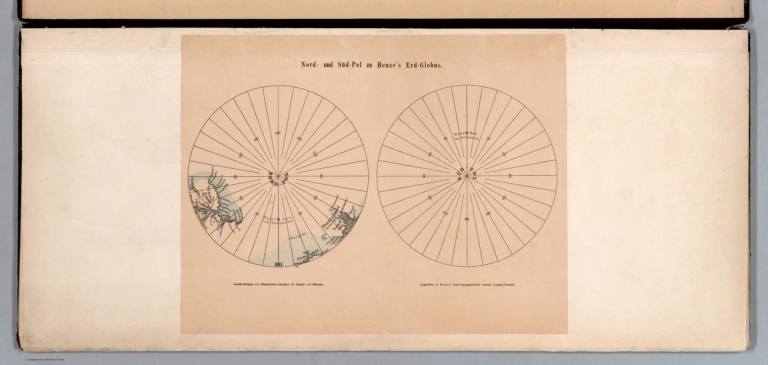


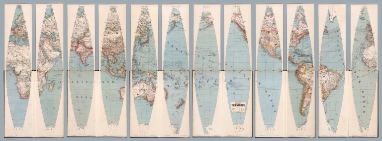


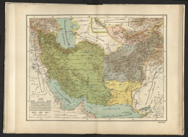
![كريد جزيره سى ختيطه سى [Map of the Island Krete].](https://media.davidrumsey.com/MediaManager/srvr?mediafile=/Size3/RUMSEY~8~1/195/10874000.jpg)