|
Full Title
Township 12 South, Range 17 East. (Compiled, drawn and published ... by Thos. H. Thompson, Tulare, California, 1891)
List No
2867.030
Note
Shows sections and subdivisions, owners (including Miller & Lux, Merritt Dorn and Lang, John Brown Colony), etc. in vicinity of La Vina.
Full Title
Township 12 South, Range 18 East. (Compiled, drawn and published ... by Thos. H. Thompson, Tulare, California, 1891)
List No
2867.031
Note
Shows sections and subdivisions, owners, etc. in vicinity of "Irrigosa."
Full Title
Range 19 East, Range 20 East, Township 12 South, Township 11 South. (Compiled, drawn and published ... by Thos. H. Thompson, Tulare, California, 1891)
List No
2867.032
Note
Relief shown by hachures. Shows sections and subdivisions, owners, etc. north and east from Riverview and Herndon, including Perrin Colony number 2.
Full Title
Range 21 East, Range 22 East, Township 12 South, Township 11 South. (Compiled, drawn and published ... by Thos. H. Thompson, Tulare, California, 1891)
List No
2867.033
Note
Relief shown by hachures. Shows sections and subdivisions, owners, etc. south and east from Friant.
Full Title
Range 23 East, Range 24 East, Township 12 South, Township 11 South. (Compiled, drawn and published ... by Thos. H. Thompson, Tulare, California, 1891)
List No
2867.034
Note
Relief shown by hachures. Shows sections and subdivisions, owners, etc. north and west from Pine Flat Reservoir.
Full Title
Range 25 East, Range 26 East, Township 10 South, Township 9 South. (Compiled, drawn and published ... by Thos. H. Thompson, Tulare, California, 1891)
List No
2867.035
Note
Relief shown by hachures. Shows sections and subdivisions, owners (including Kings River Lumber Company), etc. in the Shaver Lake area.
Full Title
Range 25 East ... Range 28 East, Township 12 South ... Township 9 South. (Compiled, drawn and published ... by Thos. H. Thompson, Tulare, California, 1891)
List No
2867.036
Note
Relief shown by hachures. Shows sections and subdivisions, owners, etc. from Kings River north in present Sierra National Forest.
Full Title
Range 29 East ... Range 31 East, Township 12 South ... Township 9 South. (Compiled, drawn and published ... by Thos. H. Thompson, Tulare, California, 1891)
List No
2867.037
Note
Relief shown by hachures. Shows sections and subdivisions, etc. along North and Middle forks of Kings River, and Crown Valley Creek in present Kings Canyon National Park area.
Full Title
Range 10 East, Range 11 East, Township 14 South, Township 13 South. (Compiled, drawn and published ... by Thos. H. Thompson, Tulare, California, 1891)
List No
2867.038
Note
Relief shown by hachures. Shows sections and subdivisions, owners, etc. in Little Panoche Creek area.
Full Title
Range 12 East, Range 13 East, Township 14 South, Township 13 South. (Compiled, drawn and published ... by Thos. H. Thompson, Tulare, California, 1891)
List No
2867.039
Note
Relief shown by hachures. Shows sections and subdivisions, owners (including Miller & Lux, H.H. Hewlett, Hewlett and Jones), etc. in Big Panoche Creek area.
Full Title
Range 14 East, Range 15 East, Township 14 South, Township 13 South. (Compiled, drawn and published ... by Thos. H. Thompson, Tulare, California, 1891)
List No
2867.040
Note
Shows sections and subdivisions, owners (including Miller & Lux, A. Borland Est.), etc. in the Mendota area.
Full Title
Range 16 East, Range 17 East, Township 14 South, Township 13 South. (Compiled, drawn and published ... by Thos. H. Thompson, Tulare, California, 1891)
List No
2867.041
Note
Shows sections and subdivisions, owners (including Miller & Lux, Bank of California), etc. in the Jamesan area.
Full Title
Township 13 South, Range 18 East. (Compiled, drawn and published ... by Thos. H. Thompson, Tulare, California, 1891)
List No
2867.042
Note
Shows sections and subdivisions, owners (including Miller & Lux, Bank of California), etc. in the Biola area.
Full Title
Township 13 South, Range 19 East. (Compiled, drawn and published ... by Thos. H. Thompson, Tulare, California, 1891)
List No
2867.043
Note
Shows sections and subdivisions, owners (including Bank of California, Charles Crocker, E.B. Perrin), etc. in the Highway City area.
Full Title
Township 13 South, Range 20 East. (Compiled, drawn and published ... by Thos. H. Thompson, Tulare, California, 1891)
List No
2867.044
Note
Shows sections and subdivisions, owners, tracts (Montpellier, Wolter, Salinger, Scandinavian Colony, Perrin Colony, etc.) in Fresno and vicinity.
Full Title
Township 13 South, Range 21 East. (Compiled, drawn and published ... by Thos. H. Thompson, Tulare, California, 1891)
List No
2867.046
Note
Shows sections and subdivisions, owners, colonies (Enterprise, Scandinavian, Nevada, Temperance, Eggers, Kutner) in Fresno and vicinity.
Full Title
Red Bank Ranch of C.M. Cole, Fresno Co, Cal. Residence & ranch of C.M. Cole, Big Dry Creek, Fresno Co., Cal. (Compiled, drawn and published from personal examinations and surveys by Thos. H. Thompson, Tulare, California, 1891)
List No
2867.047
Note
Two lithographed views on 1 sheet, b&w. Oblique bird's-eye views showing buildings, animals, tractor, horse-drawn farm machinery, etc.
Full Title
Township 13 South, Range 22 East. (Compiled, drawn and published ... by Thos. H. Thompson, Tulare, California, 1891)
List No
2867.045
Note
Relief shown by hachures. Shows sections and subdivisions, owners, Kutner Colony, Fairview Vineyard, etc. in Fancher Creek area.
Full Title
Township 13 South, Range 23 East. (Compiled, drawn and published ... by Thos. H. Thompson, Tulare, California, 1891)
List No
2867.048
Note
Relief shown by hachures. Shows sections and subdivisions, owners, etc.
Full Title
Residence, vinery and farm buildings on vineyard of 760 acres of Herman C. Eggers, Fresno. (Compiled, drawn and published from personal examinations and surveys by Thos. H. Thompson, Tulare, California, 1891)
List No
2867.049
Note
Lithographed view, b&w. Low oblique bird's-eye view showing buildings, animals, horse-drawn carriages, etc.
Full Title
Township 14 South, Range 18 East. (Compiled, drawn and published ... by Thos. H. Thompson, Tulare, California, 1891)
List No
2867.050
Note
Relief shown by hachures. Shows sections and subdivisions, owners (Bank of California, E.B. Perrin), railroad, etc. from Kerman west.
Full Title
Township 14 South, Range 19 East. (Compiled, drawn and published ... by Thos. H. Thompson, Tulare, California, 1891)
List No
2867.051
Note
Shows sections and subdivisions, owners, Fruitvale Estate, Fruit-Vale Raisin Vineyard, Perrin Colony number 4, etc.
Full Title
Residence and fruit ranch of Henry Larson, Washington Colony, Fresno. Donahoo and Kennesons' City Livery Stable and Feed Yard, cor. Merced & H Sts., Fresno. (Compiled, drawn and published from personal examinations and surveys by Thos. H. Thompson, Tulare, California, 1891)
List No
2867.052
Note
Two lithographed low oblique views, b&w. Show buildings, animals, horse-drawn carriages, etc. Includes illustration of horse "Bay Prince."
Full Title
N.W. 1/4 Tp. 14 S. R. 20 E. (Compiled, drawn and published ... by Thos. H. Thompson, Tulare, California, 1891)
List No
2867.053
Note
Shows sections and subdivisions, tracts, owners, etc. Covers area bounded by Belmont, Elm, Jensen and Cleveland avenues.
Full Title
N.E. 1/4 Tp. 14 S. R. 20 E. (Compiled, drawn and published ... by Thos. H. Thompson, Tulare, California, 1891)
List No
2867.054
Note
Shows sections and subdivisions, tracts, owners, etc. Covers area bounded by Belmont, Chestnut, Jensen and Elm avenues.
Full Title
Caledonia Vineyard Co., Fresno, 1888. (Compiled, drawn and published from personal examinations and surveys by Thos. H. Thompson, Tulare, California, 1891)
List No
2867.055
Note
Lithographed low oblique view, b&w. Show buildings, horses, wagons and carriages, etc. "Alex. Gordon, Arch. Grant" proprietors.
Full Title
Bank of California Tract & Union Colony, parts of Tp. 14S. Rs. 19 & 20 East. (Compiled, drawn and published ... by Thos. H. Thompson, Tulare, California, 1891)
List No
2867.056
Note
Shows sections and subdivisions, tracts, owners, etc. Covers area generally bounded by California, West, Washington and Cornelia avenues.
Full Title
Central California and Fresno colonies. Tp. 14 S. R.20 East. (Compiled, drawn and published ... by Thos. H. Thompson, Tulare, California, 1891)
List No
2867.057
Note
Shows sections and subdivisions, tracts, owners, etc. Covers area generally bounded by Jensen, East, Washington and West avenues.
Full Title
Hedge-Row Vineyard, Elm Avenue, Central Colona, Fresno. (with) Sandias Ranch, E.D. Edwards proprietor, Fresno. (Compiled, drawn and published from personal examinations and surveys by Thos. H. Thompson, Tulare, California, 1891)
List No
2867.058
Note
Lithographed low oblique bird's-eye view, b&w. with inset view. Show wagons, animals, etc.
Full Title
Malaga Tract and parts of Township 14 South, Ranges 20-21 East. (Compiled, drawn and published ... by Thos. H. Thompson, Tulare, California, 1891)
List No
2867.059
Note
Shows sections and subdivisions, tracts, owners, etc. Covers area around Malaga generally bounded by Jensen, Peach, Washington and East avenues.
Full Title
Township 14 South, Range 21 East. (Compiled, drawn and published ... by Thos. H. Thompson, Tulare, California, 1891)
List No
2867.060
Note
Shows sections and subdivisions, tracts, owners, etc. Covers north and east of Malaga.
Full Title
Locan Vineyard Co., Fresno Co., Cal. (Compiled, drawn and published from personal examinations and surveys by Thos. H. Thompson, Tulare, California, 1891)
List No
2867.061
Note
Lithographed low oblique bird's-eye view, b&w. Show buildings, wagons, animals, train, etc.
Full Title
Township 14 South, Range 22 East. (Compiled, drawn and published ... by Thos. H. Thompson, Tulare, California, 1891)
List No
2867.062
Note
Shows sections and subdivisions, tracts, owners, etc. Covers Sanger and vicinity. David Rumsey Collection copy has pencil annotations.
Full Title
Map of Sanger. Fresno County, California. (Compiled, drawn and published ... by Thos. H. Thompson, Tulare, California, 1891)
List No
2867.063
Note
Shows tracts, block and lot numbers, railroad, canals, etc. "Located on sections 14-15-22 & 23 T.14S. R.22E.
Full Title
Township 14 South, Range 23 East. (Compiled, drawn and published ... by Thos. H. Thompson, Tulare, California, 1891)
List No
2867.064
Note
Shows sections and subdivisions, tracts, owners, etc. Relief shown by hachures. Covers area south and east from Centerville.
Full Title
Range 24 East, Range 25 East, Township 14 South, Township 13 South. (Compiled, drawn and published ... by Thos. H. Thompson, Tulare, California, 1891)
List No
2867.065
Note
Shows sections and subdivisions, tracts, owners, etc. Relief shown by hachures. Covers Clark's, Harmon, Hills, Marks and Squaw valleys area.
Full Title
Range 27 East, Range 28 East, Township 13 South. (with) Range 26 East ... Range 29 East, Township 14 South, Township 13 South. (with) Range 30 East, Range 31 East, Township 13 South. (Compiled, drawn and published ... by Thos. H. Thompson, Tulare, California, 1891)
List No
2867.066
Note
Map with 2 ancillary maps. Shows sections and subdivisions, tracts, owners, etc. Relief shown by hachures. Scale of ancillary maps (ca. 1:126,720). Cover General Grant Grove Section and other parts of Kings Canyon National Park and parts of Sequoia National Forest.
Full Title
Range 11 East, Range 12 East, Township 15 South, Township 16 South. (with) Scandinavian Colony. (Compiled, drawn and published ... by Thos. H. Thompson, Tulare, California, 1891)
List No
2867.067
Note
Lithographed map with inset. Shows sections and subdivisions, owners, etc. Relief shown by hachures. Scale of inset (ca. 1:21,000).
Full Title
Estella Blanca Vineyard, property of F.M. Roessler, Fruitvale, Fresno Co. (with) Ranch and residence of S(tephen) Hamilton, Red Banks, Fresno. (Compiled, drawn and published from personal examinations and surveys by Thos. H. Thompson, Tulare, California, 1891)
List No
2867.068
Note
Lithographed low oblique bird's-eye view, b&w with ancillary view. Show buildings, wagons, animals, canal with boat, etc.
Full Title
Range 13 East, Range 14 East, Township 16 South, Township 15 South. (Compiled, drawn and published ... by Thos. H. Thompson, Tulare, California, 1891)
List No
2867.069
Note
Shows sections and subdivisions, owners, etc. Relief shown by hachures.
Full Title
Range 15 East, Range 16 East, Township 16 South, Township 15 South. (Compiled, drawn and published ... by Thos. H. Thompson, Tulare, California, 1891)
List No
2867.070
Note
Shows sections and subdivisions, owners, etc.
Full Title
Range 17 East, Range 18 East, Township 16 South, Township 15 South. (Compiled, drawn and published ... by Thos. H. Thompson, Tulare, California, 1891)
List No
2867.071
Note
Shows sections and subdivisions, owners, etc.
Full Title
Township 15 South, Range 19 East. (Compiled, drawn and published ... by Thos. H. Thompson, Tulare, California, 1891)
List No
2867.072
Note
Shows sections and subdivisions, owners, etc. Covers Raisin City, Perrin Colony area.
Full Title
Residence & vineyard of P.W. Hastie, Fowler, Fresno County, Cal. (Compiled, drawn and published from personal examinations and surveys by Thos. H. Thompson, Tulare, California, 1891)
List No
2867.073
Note
Lithographed low oblique bird's-eye view, b&w. Shows buildings, orchard, wagons, animals, etc.
Full Title
Township 15 South, Range 20 East. (Compiled, drawn and published ... by Thos. H. Thompson, Tulare, California, 1891)
List No
2867.074
Note
Shows sections and subdivisions, owners, etc. Covers Covell (Easton P.O.), Washington Colony, Wittram Colony area and south and west.
Full Title
Washington Colony. (with) Map of La Vina, Fresno County, California ... T.12 R.17. (Compiled, drawn and published ... by Thos. H. Thompson, Tulare, California, 1891)
List No
2867.075
Note
Lithographed map with inset. Shows sections and subdivisions, owners, etc. Covers Covell (Easton P.O.), Washington Colony and Wittram Colony. Scale of inset (1:6,000) and shows block and lot numbers, etc.
Full Title
Bonacourt Fruit Ranch of F.R. Storie, Washington Colony, Fresno. (with Bloomfield Vineyard of M.J. Lindrose, Washington Colony, Fresno. (with) Residence and ranch of P.E. Larson, Washington Colony, Fresno. (Compiled, drawn and published from personal examinations and surveys by Thos. H. Thompson, Tulare, California, 1891)
List No
2867.076
Note
Lithographed low oblique bird's-eye view, b&w with 2 inset views. Show buildings, orchards, wagons, animals, etc.
Full Title
Township 15 South, Range 21 East. (Compiled, drawn and published ... by Thos. H. Thompson, Tulare, California, 1891)
List No
2867.077
Note
Shows sections and subdivisions, owners, etc. Covers Fowler, Briggs Selma Tract, and Nye-Marden, Norris, Walter, Sierra Park and Jameson colonies area.
Full Title
Township 15 South, Range 22 East. (Compiled, drawn and published ... by Thos. H. Thompson, Tulare, California, 1891)
List No
2867.078
Note
Shows sections and subdivisions, owners, etc. Covers Parlier and Del Rey areas, and the Alameda Park, Kimble, Fortuna, Fruit Vale and Shaw colonies.
Full Title
Fancher Creek Ranch, property of James Karnes, Fresno Co. Home Ranch & residence of James Karnes, 3 miles S. of Sanger. (Compiled, drawn and published from personal examinations and surveys by Thos. H. Thompson, Tulare, California, 1891)
List No
2867.079
Note
Two lithographed low oblique views, b&w. Show Gray Mountain, Rocky Peak, Wild Cat Peak, buildings, orchards, wagons, farm machinery, train, animals, etc.
Full Title
Township 15 South, Range 23 East. (Compiled, drawn and published ... by Thos. H. Thompson, Tulare, California, 1891)
List No
2867.080
Note
Shows sections and subdivisions, owners, etc. Covers Reedley area, and the Riverside and Curtis & Shoemake colonies.
Full Title
Township 15 South, Range 24 East. (Compiled, drawn and published ... by Thos. H. Thompson, Tulare, California, 1891)
List No
2867.081
Note
Shows sections and subdivisions, owners (including California Fruit & Wine Land Company and Land & Water Company), etc. Relief shown by hachures. Covers the Orange Cove area.
Full Title
Township 16 South, Range 19 East. (Compiled, drawn and published ... by Thos. H. Thompson, Tulare, California, 1891)
List No
2867.082
Note
Shows sections and subdivisions, owners (including Timothy Paige, Mrs. J.J. Evans), etc.
Full Title
Township 16 South, Range 20 East. (Compiled, drawn and published ... by Thos. H. Thompson, Tulare, California, 1891)
List No
2867.083
Note
Shows sections and subdivisions, owners (including Timothy Paige), etc. Covers Caruthers area.
Full Title
Township 16 South, Range 21 East. (Compiled, drawn and published ... by Thos. H. Thompson, Tulare, California, 1891)
List No
2867.084
Note
Shows sections and subdivisions, owners (including Timothy Paige), etc. Covers Conejo and Wildflower area
Full Title
Township 16 South, Range 22 East. (Compiled, drawn and published ... by Thos. H. Thompson, Tulare, California, 1891)
List No
2867.085
Note
Shows sections and subdivisions, owners, railroad, canals, etc. Covers Selma and Kingsburg area and Kingsburg and Stroud colonies.
Full Title
Vineyard & ranch of S.L. Hogue, four miles east of Selma, Fresno Co., Cal. (with) Ranch, vineyard & residence of A.A. Hennick, Kingsburg, Fresno Co., Cal. (Compiled, drawn and published from personal examinations and surveys by Thos. H. Thompson, Tulare, California, 1891)
List No
2867.086
Note
Two lithographed low oblique views, b&w. Show buildings, orchards, wagons, train, animals, etc.
Full Title
Map of Selma, Fresno County, California. (Compiled, drawn and published ... by Thos. H. Thompson, Tulare, California, 1891)
List No
2867.087
Note
Shows tracts, block and lot numbers, owners of large parcels, railroad, canals, etc.
Full Title
Map of Kingsburg, Fresno County. (Compiled, drawn and published ... by Thos. H. Thompson, Tulare, California, 1891)
List No
2867.088
Note
Shows tracts, block and lot numbers, owners of large parcels, railroad, canals, etc.
Full Title
Map of Centerville. Map of Huron, Fresno County, California. Map of Kingston. Township 16 South, Range 23 East. (Compiled, drawn and published ... by Thos. H. Thompson, Tulare, California, 1891)
List No
2867.089
Note
Four maps on 1 sheet. Show tract, block and lot numbers, railroad, etc. Township map shows sections and subdivisions, owners, etc. and covers W 119 42--W119 28, N 36 35--N 36 31. David Rumsey Collection copy has additions by hand to township map.
Full Title
Range 13 East, Range 14 East, Township 18 South, Township 17 South. (Compiled, drawn and published ... by Thos. H. Thompson, Tulare, California, 1891)
List No
2867.090
Note
Shows sections and subdivisions, owners, etc. Relief shown by hachures. Covers Cantua Creek-Arroyo Hondo-Salt Creek area.
Full Title
Range 15 East, Range 16 East, Township 18 South, Township 17 South. (Compiled, drawn and published ... by Thos. H. Thompson, Tulare, California, 1891)
List No
2867.091
Note
Shows sections and subdivisions, owners, etc. Relief shown by hachures. Covers Cantua Creek-Salt Creek area.
Full Title
Range 17 East, Range 18 East, Township 18 South, Township 17 South. (Compiled, drawn and published ... by Thos. H. Thompson, Tulare, California, 1891)
List No
2867.092
Note
Shows sections and subdivisions, owners, etc. Covers Calflax and Five Points area.
Full Title
Range 19 East, Range 20 East, Township 18 South, Township 17 South. (Compiled, drawn and published ... by Thos. H. Thompson, Tulare, California, 1891)
List No
2867.093
Note
Shows sections and subdivisions, owners, etc. Covers Riverdale, Lanare, Rancho Laguna de Tache area.
Full Title
Range 21 East, Range 22 East, Township 18 South, Township 17 South. (with) Easterby Rancho T. 14. S., R. 21 E. (Compiled, drawn and published ... by Thos. H. Thompson, Tulare, California, 1891)
List No
2867.094
Note
Shows sections and subdivisions, owners, etc. Covers Kingston and Rancho Laguna de Tache.
Full Title
Range 12 East, Range 13 East, Township 20 South, Township 19 South. (Compiled, drawn and published ... by Thos. H. Thompson, Tulare, California, 1891)
List No
2867.095
Note
Shows sections and subdivisions, owners, etc. Relief shown by hachures. Covers the Los Gatos, White, Hot Springs and Walthan creeks, Kryenhagen Fresno Hot Springs area.
Full Title
Range 14 East, Range 15 East, Township 20 South, Township 19 South. (Compiled, drawn and published ... by Thos. H. Thompson, Tulare, California, 1891)
List No
2867.096
Note
Shows sections and subdivisions, owners, coal mines, railroad, etc. Relief shown by hachures. Covers the Coalinga-Los Gatos Creek area.
Full Title
Range 16 East, Range 17 East, Township 20 South, Township 19 South. (Compiled, drawn and published ... by Thos. H. Thompson, Tulare, California, 1891)
List No
2867.097
Note
Shows sections and subdivisions, owners, railroad, etc. Relief shown by hachures. Covers the Huron area.
Full Title
Range 18 East, Range 19 East, Township 20 South, Township 19 South. (with) Range 20 East, Township 19 South. (Compiled, drawn and published ... by Thos. H. Thompson, Tulare, California, 1891)
List No
2867.098
Note
Shows sections and subdivisions, owners, railroad, etc. Covers the Westhaven area.
Full Title
Range 12 East ... Range 14 East, Township 21 South, Township 22 South. (with) Range 20 East, Township 19 South. (Compiled, drawn and published ... by Thos. H. Thompson, Tulare, California, 1891)
List No
2867.099
Note
Shows sections and subdivisions, owners, railroad, etc. Relief shown by hachures. Covers the Warthan Creek area.
Full Title
Range 15 East, Range 16 East, Township 22 South, Township 21 South. (Compiled, drawn and published ... by Thos. H. Thompson, Tulare, California, 1891)
List No
2867.100
Note
Shows sections and subdivisions, owners, railroad, etc. Relief shown by hachures.
Full Title
Range 17 East, Range 18 East, Township 22 South, Township 21 South. (with) Berenda. (with) Range 15 East, Range 16 East, Township 23 South. (Compiled, drawn and published ... by Thos. H. Thompson, Tulare, California, 1891)
List No
2867.101
Note
Lithographed map with 2 insets. Shows sections and subdivisions, owners, railroad, etc. Relief shown by hachures. Berenda map is at scale (ca. 1:14,400) and shows block and lot numbers, railroad, etc.
Full Title
Reedley and portion of Reedley Colony located on Fresno Division of the Sou. Pac. Ry. ... (Compiled, drawn and published ... by Thos. H. Thompson, Tulare, California, 1891)
List No
2867.102
Note
Shows block and lot numbers, owners of large parcels, railroad, etc.
Full Title
Map of northern portion of Fresno. (Compiled, drawn and published ... by Thos. H. Thompson, Tulare, California, 1891)
List No
2867.103
Note
Shows tracts, block and lot numbers, owners of large parcels, railroad, etc.
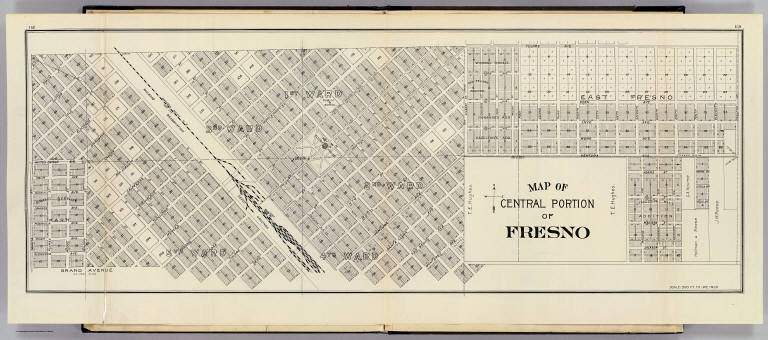
Full Title
Map of central portion of Fresno. (Compiled, drawn and published ... by Thos. H. Thompson, Tulare, California, 1891)
List No
2867.104
Note
Shows wards, tracts, block and lot numbers, owners of large parcels, railroad, etc.
Full Title
Map of southern portion of Fresno. (Compiled, drawn and published ... by Thos. H. Thompson, Tulare, California, 1891)
List No
2867.105
Note
Shows wards, tracts, block and lot numbers, owners of large parcels, railroad, etc.
Author
[Amerine, C.H., Lowman & Hanford]
Full Title
(Covers to) Lowman & Hanford's Sectional Map Of Puget Sound And Grays Harbor Country. Compiled From the Latest Official Data and Other Sources by C.H. Amerine. Published By The Lowman & Hanford Stationary & Printing Co. Seattle, Wash. 1891. Copyrighted 1891 by C.H. Amerine, Tacoma, Wash. Lith. Britton & Rey S.F.
List No
3301.001
Note
Shows from the Columbia River to Vancouver. Very detailed. Full color by county, folded into brown cloth covers 18x9 with "Lowman & Hanford's Map Of Puget Sound And Gray's Harbor Country" stamped in gilt.
Author
[Amerine, C.H., Lowman & Hanford]
Full Title
Lowman & Hanford's Sectional Map Of Puget Sound And Grays Harbor Country. Compiled From the Latest Official Data and Other Sources by C.H. Amerine. Published By The Lowman & Hanford Stationary & Printing Co. Seattle, Wash. 1891. Copyrighted 1891 by C.H. Amerine, Tacoma, Wash. Lith. Britton & Rey S.F.
List No
3301.002
Note
Shows from the Columbia River to Vancouver. Very detailed. Full color by county, folded into brown cloth covers 18x9 with "Lowman & Hanford's Map Of Puget Sound And Gray's Harbor Country" stamped in gilt.
Author
California Railway Commissioners
Full Title
Commissioners Official Railway Map of California Completed to November 15th 1891.
List No
4124.000
Note
Large map of the entire state showing all the railroads completed to date. Shows in addition, rivers, lakes, counties, cities and towns, and some connecting roads, mostly in the north. No mountains are shown.
Author
United States. Army. Corps of Engineers
Full Title
(Covers to) The Middle Tennessee and Chattanooga Campaigns of June, July, August and September 1863. (Chief of Engineers of the Army. Washington, D.C.: U.S. Government Printing Office, 1891)
List No
4249A
Note
All eight maps are derived and enlarged from an 1865 "Military Map of Middle Tennessee and parts of East Tennessee..." by C.S. Mergell (LC Civil War maps, 393) which was published in 1874. Each map says "Positions of the Troops located in 1891." Covers are half leather, red cloth covered boards with label reading "The Middle Tennessee and Chattanooga Campaign of 1863 including the Battle of Chickamauga." These maps are of great interest to historians of these battles because the level of detail regarding troop positions, etc. is very good. With printed color. Maps printed by Julius Bien & Co.
Author
United States. Army. Corps of Engineers
Full Title
(Title Page to) The Middle Tennessee and Chattanooga Campaigns of June, July, August and September 1863. (Chief of Engineers of the Army. Washington, D.C.: U.S. Government Printing Office, 1891)
List No
4249B
Note
All eight maps are derived and enlarged from an 1865 "Military Map of Middle Tennessee and parts of East Tennessee..." by C.S. Mergell (LC Civil War maps, 393) which was published in 1874. Each map says "Positions of the Troops located in 1891." Covers are half leather, red cloth covered boards with label reading "The Middle Tennessee and Chattanooga Campaign of 1863 including the Battle of Chickamauga." These maps are of great interest to historians of these battles because the level of detail regarding troop positions, etc. is very good. With printed color. Maps printed by Julius Bien & Co.
Author
[Kellogg, Sanford Cobb, 1842-, Mergell, C. S., United States. Army. Corps of Engineers]
Full Title
The Middle-Tennessee Campaign of June and July 1863, enlarged from a map compiled in 1865, by C.S. Mergell, under the direction of Col. W.E. Merrill, 1st U.S. V.V. Eng'rs, and published by the Chief of Engineers of the Army in 1874. Drawn by J. von Glumer. Positions of troops located in 1891 by Captain S.C. Kellogg, 5th Cavalry. Julius Bien & Co. lith. (Washington, D.C.: U.S. Government Printing Office, 1891)
List No
4249.001
Note
Col. lithographed map. Relief shown by hachures and spot heights. Includes lengthy note "Legend." Shows actions June 23-28.
Author
[Kellogg, Sanford Cobb, 1842-, Mergell, C. S., United States. Army. Corps of Engineers]
Full Title
The Middle-Tennessee Campaign of June and July 1863, enlarged from a map compiled in 1865, by C.S. Mergell, under the direction of Col. W.E. Merrill, 1st U.S. V.V. Eng'rs, and published by the Chief of Engineers of the Army in 1874. Drawn by J. von Glumer. Positions of troops located in 1891 by Captain S.C. Kellogg, 5th Cavalry. Julius Bien & Co. lith. (Washington, D.C.: U.S. Government Printing Office, 1891)
List No
4249.002
Note
Col. lithographed map. Relief shown by hachures and spot heights. Includes lengthy note "Legend." Shows actions June 28-July 7th.
Author
[Kellogg, Sanford Cobb, 1842-, Mergell, C. S., United States. Army. Corps of Engineers]
Full Title
The Middle-Tennessee Campaign of June and July 1863, enlarged from a map compiled in 1865, by C.S. Mergell, under the direction of Col. W.E. Merrill, 1st U.S. V.V. Eng'rs, and published by the Chief of Engineers of the Army in 1874. Drawn by J. von Glumer. Positions of troops located in 1891 by Captain S.C. Kellogg, 5th Cavalry. Julius Bien & Co. lith. (Washington, D.C.: U.S. Government Printing Office, 1891)
List No
4249.003
Note
Col. lithographed map. Relief shown by hachures and spot heights. Includes lengthy note "Legend." Shows actions July 7-Aug. 19.
Author
[Kellogg, Sanford Cobb, 1842-, Mergell, C. S., United States. Army. Corps of Engineers]
Full Title
The Chattanooga Campaign of August and September 1863, enlarged from a map compiled in 1865, by C.S. Mergell, under the direction of Col. W.E. Merrill, 1st U.S. V.V. Eng'rs, and published by the Chief of Engineers of the Army in 1874. Drawn by J. von Glumer. Positions of troops located in 1891 by Captain S.C. Kellogg, 5th Cavalry. Julius Bien & Co. lith. (Washington, D.C.: U.S. Government Printing Office, 1891)
List No
4249.004
Note
Col. lithographed map. Relief shown by hachures and spot heights. Includes lengthy note "Legend." Shows actions July 15-Aug. 31.
Author
[Kellogg, Sanford Cobb, 1842-, Mergell, C. S., United States. Army. Corps of Engineers]
Full Title
The Chattanooga Campaign of August and September 1863, enlarged from a map compiled in 1865, by C.S. Mergell, under the direction of Col. W.E. Merrill, 1st U.S. V.V. Eng'rs, and published by the Chief of Engineers of the Army in 1874. Drawn by J. von Glumer. Positions of troops located in 1891 by Captain S.C. Kellogg, 5th Cavalry. Julius Bien & Co. lith. (Washington, D.C.: U.S. Government Printing Office, 1891)
List No
4249.005
Note
Col. lithographed map. Relief shown by hachures and spot heights. Includes lengthy note "Legend." Shows actions Aug. 29-Sept. 17.
Author
[Kellogg, Sanford Cobb, 1842-, Mergell, C. S., United States. Army. Corps of Engineers]
Full Title
The Chattanooga Campaign of August and September 1863, enlarged from a map compiled in 1865, by C.S. Mergell, under the direction of Col. W.E. Merrill, 1st U.S. V.V. Eng'rs, and published by the Chief of Engineers of the Army in 1874. Drawn by J. von Glumer. Positions of troops located in 1891 by Captain S.C. Kellogg, 5th Cavalry. Julius Bien & Co. lith. (Washington, D.C.: U.S. Government Printing Office, 1891)
List No
4249.006
Note
Col. lithographed map. Relief shown by hachures and spot heights. Includes lengthy note "Legend." Shows actions Sept. 9-19.
Author
[Kellogg, Sanford Cobb, 1842-, Mergell, C. S., United States. Army. Corps of Engineers]
Full Title
The Chattanooga Campaign of August and September 1863, enlarged from a map compiled in 1865, by C.S. Mergell, under the direction of Col. W.E. Merrill, 1st U.S. V.V. Eng'rs, and published by the Chief of Engineers of the Army in 1874. Drawn by J. von Glumer. Positions of troops located in 1891 by Captain S.C. Kellogg, 5th Cavalry. Movements and positions preceding Battle of Chickamauga, locations made by Captain S.C. Kellogg, 5th Cavalry, 1891. Julius Bien & Co. lith. (Washington, D.C.: U.S. Government Printing Office, 1891)
List No
4249.007
Note
Two col. lithographed maps on 1 sheet. Scale of "Movements and positions preceding Battle of Chickamauga ..." (ca. 1:82,000), covering W 85o 20'--W 85o05'/N 35o10'--N 34o40'). Relief shown by hachures and spot heights. Includes lengthy note "Legend." In margin: Errata * In last line of legend for westward read eastward. Shows actions July 10-Sept. 13.
Author
[Bromley, George Washington, Bromley, Walter Scott]
Full Title
(Covers to) Atlas of the city of New York. Manhattan Island. From actual surveys and official plans by Geo. W. & Walter S. Bromley, civil engineers. Published by G.W. Bromley & Co., 120 Nth. Seventh St., Philadelphia. 1891. Engraved by Rudolph Spiel, 30 N. Fifth St., Phila. Printed by F. Bourquin, 31 S. Sixth St., Phila.
List No
4253A
Note
Bound in half leather black cloth covered boards with "Atlas of the City of New York. Manhattan Island. G.W. Bromley & Co. 120 North Seventh St. Philadelphia 1891" embossed in gold.
Author
[Bromley, George Washington, Bromley, Walter Scott]
Full Title
(Contents to) Atlas of the city of New York. Manhattan Island. From actual surveys and official plans by Geo. W. & Walter S. Bromley, civil engineers. Published by G.W. Bromley & Co., 120 Nth. Seventh St., Philadelphia. 1891. Engraved by Rudolph Spiel, 30 N. Fifth St., Phila. Printed by F. Bourquin, 31 S. Sixth St., Phila.
List No
4253B
Note
Index map by sections and wards, and tabular "Block index." Front endpaper.
Author
[Bromley, George Washington, Bromley, Walter Scott]
Full Title
(Title Page to) Atlas of the city of New York. Manhattan Island. From actual surveys and official plans by Geo. W. & Walter S. Bromley, civil engineers. Published by G.W. Bromley & Co., 120 Nth. Seventh St., Philadelphia. 1891. Engraved by Rudolph Spiel, 30 N. Fifth St., Phila. Printed by F. Bourquin, 31 S. Sixth St., Phila.
List No
4253C
Note
Includes illustration.
Author
[Bromley, George Washington, Bromley, Walter Scott]
Full Title
(Contents to) Atlas of the city of New York. Manhattan Island. From actual surveys and official plans by Geo. W. & Walter S. Bromley, civil engineers. Published by G.W. Bromley & Co., 120 Nth. Seventh St., Philadelphia. 1891. Engraved by Rudolph Spiel, 30 N. Fifth St., Phila. Printed by F. Bourquin, 31 S. Sixth St., Phila.
List No
4253D
Note
Street index.
Author
[Bromley, George Washington, Bromley, Walter Scott]
Full Title
(Contents to) Atlas of the city of New York. Manhattan Island. From actual surveys and official plans by Geo. W. & Walter S. Bromley, civil engineers. Published by G.W. Bromley & Co., 120 Nth. Seventh St., Philadelphia. 1891. Engraved by Rudolph Spiel, 30 N. Fifth St., Phila. Printed by F. Bourquin, 31 S. Sixth St., Phila.
List No
4253E
Note
Street index.
Full Title
Outline and index map of New York City. Manhattan Island. (By Geo. W. & Walter S. Bromley, civil engineers. Published by G.W. Bromley & Co., 120 Nth. Seventh St., Philadelphia. 1891. Engraved by Rudolph Spiel, 30 N. Fifth St., Phila. Printed by F. Bourquin, 31 S. Sixth St., Phila.)
List No
4253.001
Note
An index map to plates. Includes explanation of colors and symbols used on maps, and inset. Oriented with north toward upper right. David Rumsey Collection copy includes pencil annotations.
Full Title
Ward 1, New York City. (By Geo. W. & Walter S. Bromley, civil engineers. Published by G.W. Bromley & Co., 120 Nth. Seventh St., Philadelphia. 1891. Engraved by Rudolph Spiel, 30 N. Fifth St., Phila. Printed by F. Bourquin, 31 S. Sixth St., Phila.)
List No
4253.002
Note
Lithographed map. Hand col. Covers Financial District area south of Liberty St. including Battery Park, Trinity Church and U.S. Custom House. Shows buildings with construction materials, number of stories, house number and use or occupant; water mains with size, sewers, old farm lines with owner names, old water courses, block dimensions, street widths, lot numbers and dimensions, spot heights and block numbers, wharves, etc.
Full Title
Part of wards 2, 3, 4, 5, & 6, New York City. (By Geo. W. & Walter S. Bromley, civil engineers. Published by G.W. Bromley & Co., 120 Nth. Seventh St., Philadelphia. 1891. Engraved by Rudolph Spiel, 30 N. Fifth St., Phila. Printed by F. Bourquin, 31 S. Sixth St., Phila.)
List No
4253.003
Note
Lithographed map. Hand col. Covers area north of Liberty and south of Jay, Thomas and Pearl streets, including St. Paul's Chapel, Court House, City Hall and Washington Market. Shows buildings with construction materials, number of stories, house number and use or occupant; water mains with size, sewers, old farm lines with owner names, old water courses, block dimensions, street widths, lot numbers and dimensions, spot heights and block numbers, wharves, etc.
Full Title
Part of wards 2, 4 & 7, New York City. (By Geo. W. & Walter S. Bromley, civil engineers. Published by G.W. Bromley & Co., 120 Nth. Seventh St., Philadelphia. 1891. Engraved by Rudolph Spiel, 30 N. Fifth St., Phila. Printed by F. Bourquin, 31 S. Sixth St., Phila.)
List No
4253.004
Note
Lithographed map. Hand col. Covers area bounded by Liberty St., Maiden Lane, South St., Market St., Division St., Park Row and William St., including Franklin Square and Fulton Market. Shows buildings with construction materials, number of stories, house number and use or occupant; water mains with size, sewers, old farm lines with owner names, old water courses, block dimensions, street widths, lot numbers and dimensions, spot heights and block numbers, wharves, etc.
Full Title
Part of wards 5, 6, 8 & 14, New York City. (By Geo. W. & Walter S. Bromley, civil engineers. Published by G.W. Bromley & Co., 120 Nth. Seventh St., Philadelphia. 1891. Engraved by Rudolph Spiel, 30 N. Fifth St., Phila. Printed by F. Bourquin, 31 S. Sixth St., Phila.)
List No
4253.005
Note
Lithographed map. Hand col. Covers area bounded by West, Jay, Thomas, Pearl, Centre, Broome and Spring streets, including the Tombs, Criminal Court building, St. John Chapel and Clinton Market. Shows buildings with construction materials, number of stories, house number and use or occupant; water mains with size, sewers, old farm lines with owner names, old water courses, block dimensions, street widths, lot numbers and dimensions, spot heights and block numbers, wharves, etc.
Full Title
Part of wards 6, 10, 13, 14, New York City. (By Geo. W. & Walter S. Bromley, civil engineers. Published by G.W. Bromley & Co., 120 Nth. Seventh St., Philadelphia. 1891. Engraved by Rudolph Spiel, 30 N. Fifth St., Phila. Printed by F. Bourquin, 31 S. Sixth St., Phila.)
List No
4253.006
Note
Lithographed map. Hand col. Covers area bounded by Centre, Pearl, Division, Attorney and Broome streets, including Chatham Square, Five Points House of Industry and Five Points Mission. Shows buildings with construction materials, number of stories, house number and use or occupant; water mains with size, sewers, old farm lines with owner names, old water courses, block dimensions, street widths, lot numbers and dimensions, spot heights and block numbers, etc.
Full Title
Part of ward 7, New York City. (By Geo. W. & Walter S. Bromley, civil engineers. Published by G.W. Bromley & Co., 120 Nth. Seventh St., Philadelphia. 1891. Engraved by Rudolph Spiel, 30 N. Fifth St., Phila. Printed by F. Bourquin, 31 S. Sixth St., Phila.)
List No
4253.007
Note
Lithographed map. Hand col. Covers area bounded by South, Corlears, Grand, Division and Market streets including Gouverneur Hospital. Shows buildings with construction materials, number of stories, house number and use or occupant; water mains with size, sewers, old farm lines with owner names, old water courses, block dimensions, street widths, lot numbers and dimensions, spot heights and block numbers, wharves, slips, etc.
|