|
Author
Ilyin, A.
Full Title
Karta glavneishikh lechebnykh mest Evropy [Map of Major Healing Places in Europe].
List No
15953.000
Note
Date estimated
Author
Stanford, Edward, 1827-1904
Full Title
(Covers to) A Catalogue of Maps, Atlases, Books, and Other Publications Issued or Sold by Edward Stanford.
List No
15923.001
Author
Stanford, Edward, 1827-1904
Full Title
(Title page to) A Catalogue of Maps, Atlases, Books, and Other Publications Issued or Sold by Edward Stanford.
List No
15923.003
Author
Stanford, Edward, 1827-1904
Full Title
(Text page) Preface. A Catalogue of Maps, Atlases, Books, and Other Publications Issued or Sold by Edward Stanford.
List No
15923.004
Author
Stanford, Edward, 1827-1904
Full Title
(Contents to) A Catalogue of Maps, Atlases, Books, and Other Publications Issued or Sold by Edward Stanford.
List No
15923.005
Author
Stanford, Edward, 1827-1904
Full Title
(Text page) Methods of Map Mounting. A Catalogue of Maps, Atlases, Books, and Other Publications Issued or Sold by Edward Stanford.
List No
15923.006
Author
Stanford, Edward, 1827-1904
Full Title
(Text page) Methods of Map Mounting. (con't.) A Catalogue of Maps, Atlases, Books, and Other Publications Issued or Sold by Edward Stanford.
List No
15923.007
Author
Stanford, Edward, 1827-1904
Full Title
(Text page) Methods of Map Mounting. (con't.) A Catalogue of Maps, Atlases, Books, and Other Publications Issued or Sold by Edward Stanford.
List No
15923.008
Author
Stanford, Edward, 1827-1904
Full Title
(Text page) Methods of Map Mounting. (con't.) A Catalogue of Maps, Atlases, Books, and Other Publications Issued or Sold by Edward Stanford.
List No
15923.009
Author
Stanford, Edward, 1827-1904
Full Title
(Text page) Methods of Map Mounting. (con't.) A Catalogue of Maps, Atlases, Books, and Other Publications Issued or Sold by Edward Stanford.
List No
15923.010
Author
Stanford, Edward, 1827-1904
Full Title
(Text page) Methods of Map Mounting. (con't.) A Catalogue of Maps, Atlases, Books, and Other Publications Issued or Sold by Edward Stanford.
List No
15923.011
Author
Stanford, Edward, 1827-1904
Full Title
(Text page) Methods of Map Mounting. (con't.) A Catalogue of Maps, Atlases, Books, and Other Publications Issued or Sold by Edward Stanford.
List No
15923.012
Author
Stanford, Edward, 1827-1904
Full Title
(Text page) Methods of Map Mounting. (con't.) A Catalogue of Maps, Atlases, Books, and Other Publications Issued or Sold by Edward Stanford.
List No
15923.013
Author
Stanford, Edward, 1827-1904
Full Title
(Text page) Methods of Map Mounting. (con't.) A Catalogue of Maps, Atlases, Books, and Other Publications Issued or Sold by Edward Stanford.
List No
15923.014
Author
Stanford, Edward, 1827-1904
Full Title
(Composite text to) A Catalogue of Maps, Atlases, Books, and Other Publications Issued or Sold by Edward Stanford.
List No
15923.015
Author
Hudson-Kimberly Pub. Co.
List No
15315.000
Note
Date estimated.
Author
Wyld, James, 1812-1887
Full Title
(Covers to) Wyld's new map of gold fields of Transvaal. James Wyld, Geographer to the Queen, 11 & 12, Charing Cross, S.W. and 2, Royal Exchange, E.C.
List No
14268.001
Note
Covers to Wyld's new map of gold fields of Transvaal, published in London, circa 1890. Brown board covers. With title and imprint printed on paper pasted to front cover, as well as a pasted spine title: Goldfields of Transvaal. Unfolded to 18 x 26 cm. Verso of front cover has advertisement for various map series by Wyld. Front cover torn apart from item on this copy. (Date taken from map.)
Author
Wyld, James, 1812-1887
Full Title
Wyld's new map of the gold fields of the Transvaal. Drawn, lithographed & published by James Wyld, Geographer to the Queen, 11 & 12 Charing Cross, S.W. & 2 Royal Exchange London, E.C.
List No
14268.002
Note
Colored lithographed map of the gold fields of Transvaal, South Africa. Shows district boundaries, railways, wagon roads, mining properties, mountains, hills, lakes, drainage, fresh water, forests, marshlands, coastline, islands and burial places, such as of the Swazi Kings, as well as indigenous peoples and bordering areas. Gold fields represented in yellow. Relief shown with hachures and spot heights. Includes longitudinal and latitudinal lines, as well as a legend and a bar scale. Indexed to indicate mining properties, with index at upper left. With inset map: Sketch plan of the relative position of the principal gold-bearing properties of the Sheba Hill. Inset has a compass rose, orienting north toward upper left of sheet. Map is 64 x 82 cm, on sheet 68 x 88 cm. Map segmented into thirty-two rectangles, mounted on linen. Folded and housed within brown board covers.
Author
Wyld, James, 1812-1887
Full Title
(Advertisement to) James Wyld, Geographer to the Queen, 11 and 12, Charing Cross, S.W., and 2, Royal Exchange, E.C. (1).
List No
14268.003
Note
Advertisement within Wyld's new map of gold fields of Transvaal. Includes Wyld's Traveling, London, Cycling, Military Staff and Gold field map series. On paper pasted to verso of front cover. "Maps, charts, plans of esttes, lines of railway, &c., accurately compiled, drawn, copied, reduced, or enlarged, and engraved or lithographed." With handwritten annotation, in pencil: (ca. 1890). Includes Wyld's Library Series, including World, Asia and Africa. On paper pasted to verso of a map segment, which appears adjacent to advertisement on verso of front cover. "Maps, charts, plans of esttes, lines of railway, &c., accurately compiled, drawn, copied, reduced, or enlarged, and engraved or lithographed."
Author
Kinnear, Josiah
Full Title
INDEXED COMMERCIAL MAP OF COLUMBUS, OHIO
List No
15435.000
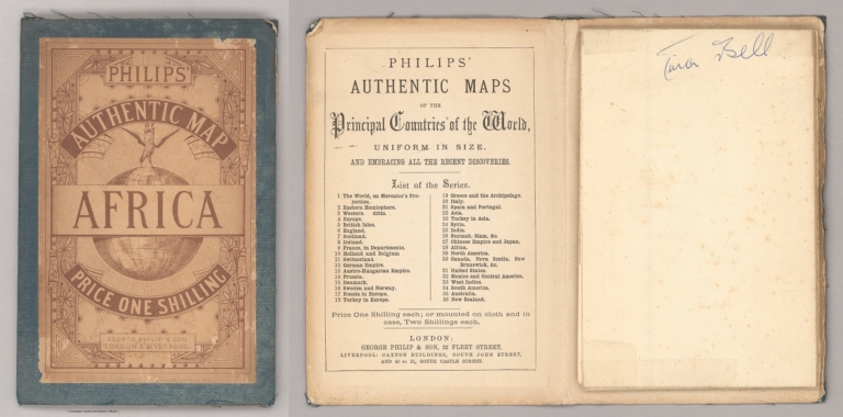
Author
Philip, George
Full Title
(Covers to) Africa. George Philip & Son, London & Liverpool.
List No
2272.001
Note
Date estimated
Author
Philip, George
Full Title
Africa. George Philip & Son, London & Liverpool.
List No
2272.002
Note
Date estimated
Author
Smith, W.H. & Son.
Full Title
(Covers to) Environs Of London. W.H. Smith & Son, 186 Strand, London.
List No
3260.001
Note
Date estimated.
Author
Smith, W.H. & Son.
Full Title
Environs Of London. W.H. Smith & Son, 186 Strand, London.
List No
3260.002
Note
Date estimated.
Author
[United States. Naval Oceanographic Office, United States. Department of the Navy. Bureau of Navigation, Witzel, H. M. (Horace Mark), 1858-1927, Hayden, Edward Everett, 1858-1932, Picking, Henry F. (Henry Forry), 1840-1899]
Full Title
Pilot chart of the North Atlantic Ocean : January, 1890. Date of publication, December 30, 1890. Division of Marine Meteorology, H. M. Witzel, Lieut. U.S.N. Marine Meteorologist, Everett Hayden. Published monthly at Hydrographic Office, Navy Department, Washington, D.C. Henry F. Picking, Captain, U.S.N. Hydrographer.
List No
14389.003
Note
Nautical chart of the North Atlantic Ocean representing January, 1890. Shows cities, coastlines, shoals, depths, islands, sailing routes, ocean currents, storm tracks, weather forecasts, fog belts, equatorial rains, wind force and directions, as well as ice fields, icebergs and the limits of ice coverage. Includes latitudinal and longitudinal lines, a legend and compass rose with north oriented toward top of sheet. Descriptive text throughout, such as reports on weather, barometric pressure, dangerous obstructions to navigation along the coast, tidal rivers, hurricanes and other storms. Insets: North Atlantic storms : June and October, lat. 23° to 55° ... -- June and October, lat. 20° to 23° -- June and October, lat. 10° to 20° -- Storm signals, Atlantic and Gulf Coast of the United States. Colored lithograph, with infographics overlaid upon geography. Chart is 54 x 80 cm, on double sheet 61 x 86 cm. "The variation is for 1888."
Author
[United States. Naval Oceanographic Office, United States. Department of the Navy. Bureau of Navigation, Witzel, H. M. (Horace Mark), 1858-1927, Hayden, Edward Everett, 1858-1932, Picking, Henry F. (Henry Forry), 1840-1899]
Full Title
Pilot chart of the North Atlantic Ocean : February, 1890. Date of publication, January 31, 1890. Division of Marine Meteorology, H. M. Witzel, Lieut. U.S.N. Marine Meteorologist, Everett Hayden. Published monthly at Hydrographic Office, Navy Department, Washington, D.C. Henry F. Picking, Captain, U.S.N. Hydrographer.
List No
14389.004
Note
Nautical chart of the North Atlantic Ocean representing February, 1890. Shows cities, coastlines, shoals, depths, islands, sailing routes, ocean currents, storm tracks, weather forecasts, fog belts, equatorial rains, wind force and directions, as well as ice fields, icebergs and the limits of ice coverage. Includes latitudinal and longitudinal lines, a legend and compass rose with north oriented toward top of sheet. Descriptive text throughout, such as reports on weather, barometric pressure, storms, an electric phenomenon, the derelict American schooner "Jacob M. Haskell", and signals for information, storms and nighttime. Insets: North Atlantic storms : June and October, lat. 23° to 55° ... -- June and October, lat. 20° to 23° -- June and October, lat. 10° to 20° -- Storm signals, Atlantic and Gulf Coast of the United States. Colored lithograph, with infographics overlaid upon geography. Chart is 54 x 80 cm, on double sheet 61 x 86 cm. "The variation is for 1889."
Author
[United States. Naval Oceanographic Office, United States. Department of the Navy. Bureau of Navigation, Witzel, H. M. (Horace Mark), 1858-1927, Hayden, Edward Everett, 1858-1932, Picking, Henry F. (Henry Forry), 1840-1899]
Full Title
Pilot chart of the North Atlantic Ocean : March, 1890. Date of publication, February 28, 1890. Division of Marine Meteorology, H. M. Witzel, Lieut. U.S.N. Marine Meteorologist, Everett Hayden. Published monthly at Hydrographic Office, Navy Department, Washington, D.C. Henry F. Picking, Captain, U.S.N. Hydrographer.
List No
14389.005
Note
Nautical chart of the North Atlantic Ocean representing March, 1890. Shows cities, coastlines, shoals, depths, islands, sailing routes, ocean currents, storm tracks, weather forecasts, fog belts, equatorial rains, wind force and directions, as well as ice fields, icebergs and the limits of ice coverage. Includes latitudinal and longitudinal lines, a legend and compass rose with north oriented toward top of sheet. Descriptive text throughout, such as reports on weather, barometric pressure, icebergs, dangerous obstructions to navigation along the coast, surface and sub-surface temperatures, and signals for information, storms and nighttime. Insets: Sea-Water temperature -- North Atlantic storms : June and October, lat. 23° to 55° ... -- June and October, lat. 20° to 23° -- June and October, lat. 10° to 20° -- Storm signals, Atlantic and Gulf Coast of the United States. Colored lithograph, with infographics overlaid upon geography. Chart is 54 x 80 cm, on double sheet 61 x 86 cm. "The variation is for 1889."
Author
[United States. Naval Oceanographic Office, United States. Department of the Navy. Bureau of Navigation, Witzel, H. M. (Horace Mark), 1858-1927, Hayden, Edward Everett, 1858-1932, Picking, Henry F. (Henry Forry), 1840-1899]
Full Title
Pilot chart of the North Atlantic Ocean : April, 1890. Date of publication, March 31, 1890. Division of Marine Meteorology, H. M. Witzel, Lieut. U.S.N. Marine Meteorologist, Everett Hayden. Published monthly at Hydrographic Office, Navy Department, Washington, D.C. Henry F. Picking, Captain, U.S.N. Hydrographer.
List No
14389.006
Note
Nautical chart of the North Atlantic Ocean representing April, 1890. Shows cities, coastlines, shoals, depths, islands, sailing routes, ocean currents, storm tracks, weather forecasts, fog belts, equatorial rains, wind force and directions, as well as ice fields, icebergs and the limits of ice coverage. Includes latitudinal and longitudinal lines, a legend and compass rose with north oriented toward top of sheet. Descriptive text throughout, such as reports on weather, barometric pressure, icebergs, dangerous obstructions to navigation along the coast, the use of oil on seas, and signals for information, storms and nighttime. Insets: North Atlantic storms : June and October, lat. 23° to 55° ... -- June and October, lat. 20° to 23° -- June and October, lat. 10° to 20° -- Storm signals, Atlantic and Gulf Coast of the United States. Colored lithograph, with infographics overlaid upon geography. Chart is 54 x 80 cm, on double sheet 61 x 86 cm. "The variation is for 1889."
Author
[United States. Naval Oceanographic Office, United States. Department of the Navy. Bureau of Navigation, Witzel, H. M. (Horace Mark), 1858-1927, Hayden, Edward Everett, 1858-1932, Picking, Henry F. (Henry Forry), 1840-1899]
Full Title
Pilot chart of the North Atlantic Ocean : May, 1890. Date of publication, April 30, 1890. Division of Marine Meteorology, H. M. Witzel, Lieut. U.S.N. Marine Meteorologist, Everett Hayden. Published monthly at Hydrographic Office, Navy Department, Washington, D.C. Henry F. Picking, Captain, U.S.N. Hydrographer.
List No
14389.007
Note
Nautical chart of the North Atlantic Ocean representing May, 1890. Shows cities, coastlines, shoals, depths, islands, sailing routes, ocean currents, storm tracks, weather forecasts, fog belts, equatorial rains, wind force and directions, as well as ice fields, icebergs and the limits of ice coverage. Includes latitudinal and longitudinal lines, a legend and compass rose with north oriented toward top of sheet. Descriptive text throughout, such as reports on weather, barometric pressure, ice, dangerous obstructions to navigation along the coast, the use of oil on seas, and signals for information, storms and nighttime. Insets: North Atlantic storms : June and October, lat. 23° to 55° ... -- June and October, lat. 20° to 23° -- June and October, lat. 10° to 20° -- Storm signals, Atlantic and Gulf Coast of the United States. Colored lithograph, with infographics overlaid upon geography. Chart is 54 x 80 cm, on double sheet 61 x 86 cm. "The variation is for 1888."
Author
[United States. Naval Oceanographic Office, United States. Department of the Navy. Bureau of Navigation, Witzel, H. M. (Horace Mark), 1858-1927, Hayden, Edward Everett, 1858-1932, Picking, Henry F. (Henry Forry), 1840-1899]
Full Title
Pilot chart of the North Atlantic Ocean : June, 1890. Date of publication, May 29. Division of Marine Meteorology, H. M. Witzel, Lieut. U.S.N. Marine Meteorologist, Everett Hayden. Published monthly at Hydrographic Office, Navy Department, Washington, D.C. Henry F. Picking, Captain, U.S.N. Hydrographer.
List No
14389.008
Note
Nautical chart of the North Atlantic Ocean representing June, 1890. Shows cities, coastlines, shoals, depths, islands, sailing routes, ocean currents, storm tracks, weather forecasts, fog belts, equatorial rains, wind force and directions, as well as ice fields, icebergs and the limits of ice coverage. Includes latitudinal and longitudinal lines, a legend and compass rose with north oriented toward top of sheet. Descriptive text throughout, such as reports on weather, barometric pressure, collisions with icebergs, dangerous obstructions to navigation along the coast, and signals for information, storms and nighttime. Insets: The Hurricane of November 25, 1888 : Noon, G.M.T. -- North Atlantic storms : June and October, lat. 23° to 55° ... -- June and October, lat. 20° to 23° -- June and October, lat. 10° to 20° -- Storm signals, Atlantic and Gulf Coast of the United States. Colored lithograph, with infographics overlaid upon geography. Chart is 54 x 80 cm, on double sheet 61 x 86 cm. "The variation is for 1888."
Author
[United States. Naval Oceanographic Office, United States. Department of the Navy. Bureau of Navigation, Witzel, H. M. (Horace Mark), 1858-1927, Hayden, Edward Everett, 1858-1932, Picking, Henry F. (Henry Forry), 1840-1899]
Full Title
Pilot chart of the North Atlantic Ocean : July, 1890. Date of publication, June 30. Division of Marine Meteorology, H. M. Witzel, Lieut. U.S.N. Marine Meteorologist, Everett Hayden. Published monthly at Hydrographic Office, Navy Department, Washington, D.C. Henry F. Picking, Captain, U.S.N. Hydrographer.
List No
14389.009
Note
Nautical chart of the North Atlantic Ocean representing July, 1890. Shows cities, coastlines, shoals, depths, islands, sailing routes, ocean currents, storm tracks, weather forecasts, fog belts, equatorial rains, wind force and directions, as well as ice fields, icebergs and the limits of ice coverage. Includes latitudinal and longitudinal lines, a legend and compass rose with north oriented toward top of sheet. Descriptive text throughout, such as reports on weather, barometric pressure, hurricanes, derelicts towed in and wrecks destroyed, dangerous obstructions to navigation along the coast, ice, monsoons, and signals for information, storms and nighttime. Insets: Hurricanes in the North Atlantic : Typical circulation of the wind, from actual observation -- North Atlantic storms : June and October, lat. 23° to 55° ... -- June and October, lat. 20° to 23° -- June and October, lat. 10° to 20° -- Storm signals, Atlantic and Gulf Coast of the United States. Colored lithograph, with infographics overlaid upon geography. Chart is 54 x 80 cm, on double sheet 61 x 86 cm. "The variation is for 1888."
Author
[United States. Naval Oceanographic Office, United States. Department of the Navy. Bureau of Navigation, Witzel, H. M. (Horace Mark), 1858-1927, Hayden, Edward Everett, 1858-1932, Picking, Henry F. (Henry Forry), 1840-1899]
Full Title
Pilot chart of the North Atlantic Ocean : August, 1890. Date of publication, July 31. Division of Marine Meteorology, H. M. Witzel, Lieut. U.S.N. Marine Meteorologist, Everett Hayden. Published monthly at Hydrographic Office, Navy Department, Washington, D.C. Henry F. Picking, Captain, U.S.N. Hydrographer.
List No
14389.010
Note
Nautical chart of the North Atlantic Ocean representing August, 1890. Shows cities, coastlines, shoals, depths, islands, sailing routes, ocean currents, storm tracks, weather forecasts, fog belts, equatorial rains, wind force and directions, as well as ice fields, icebergs and the limits of ice coverage. Includes latitudinal and longitudinal lines, a legend and compass rose with north oriented toward top of sheet. Descriptive text throughout, such as reports on weather, barometric pressure, hurricanes, dangerous obstructions to navigation along the coast, and signals for information, storms and nighttime. Insets: The great hurricane of August, 1887 : Aug. 21, 1887 -- Aug. 22, 1887 -- Aug. 23, 1887 -- North Atlantic storms : June and October, lat. 23° to 55° ... -- June and October, lat. 20° to 23° -- June and October, lat. 10° to 20° -- Storm signals, Atlantic and Gulf Coast of the United States. Colored lithograph, with infographics overlaid upon geography. Chart is 54 x 80 cm, on double sheet 61 x 86 cm. "The variation is for 1888."
Author
Harris & Mills
Full Title
(Covers to) A Chart Of 187 Mechanical Movements, With Description Of Each.
List No
15290.001
Note
Date estimated.
Author
Harris & Mills
Full Title
A Chart Of 187 Mechanical Movements, With Description Of Each.
List No
15290.002
Note
Date estimated.
Author
Harris & Mills
Full Title
(Composite text page to) A Chart Of 187 Mechanical Movements, With Description Of Each.
List No
15290.003
Note
Date estimated.
Author
Mevius, A.
Full Title
[Mining Map of the Donetsk Coal Basin] Горнопромышленная карта Донецкого камнеугольного бассейна
List No
15238.002
Author
Mevius, A.
Full Title
(Map 1) [Mining Map of the Donetsk Coal Basin] Горнопромышленная карта Донецкого камнеугольного бассейна
List No
15238.003
Author
Mevius, A.
Full Title
(Map 2) [Mining Map of the Donetsk Coal Basin] Горнопромышленная карта Донецкого камнеугольного бассейна
List No
15238.004
Author
BOYACIYAN, Arşag Agop (1837 - 1914)
Full Title
اوروپا (Europe)
List No
15191.000
Author
Survey of India
Full Title
District Darrang / Assam.
List No
10620.000
Author
[Geological Survey (U.S.), Goetzmann, William H.]
Full Title
Exploration and settlement : 1850-1890 / compiled from information provided by William H. Goetzmann, Univertsity of Texas, 1966.
List No
14359.102
Note
Historical map representing the United States, featuring voyages of exploration and settlement from 1850 to 1890. Maps show the routes of explorers, settlements (including both colonial and indigenous), forts, railways, roads, trails, canals, mines, the extent of colonized area, topography, bodies of water, coastlines and islands. Relief shown with shading. Includes legends, as well as a bar scale and scale statement. With inset map: Alaska. Colored lithograph. Map is 20 x 30 cm, on sheet 49 x 35 cm. Accompanied by descriptive text, with references. Appears in Special subject maps section, subsection History.
Author
[Suomen Maantieteellinen Seura, Tilgmann, Ferdinand, 1832-1911]
Full Title
No. 5. Isotermit : Eri kuukausina ja koko vuonna. 1881-1890. = Isotermer : För månaderna och året. 1881-1890. : Vuosi. = Året -- Tammikuu. = Januari. -- Helmikuu. = Februari. -- Maaliskuu. = Mars. -- Huhtikuu. = April. -- Toukokuu. = Maj. -- Kesäkuu. = Juni. -- Heinäkuu. = Juli. -- Elokuu. = Augusti. -- Syyskuu. = September. -- Lokakuu. = Oktober. -- Marraskuu. = November. -- Joulukuu. = December.
List No
14366.014
Note
Thirteen climate maps of Finland. Maps feature isotherms - lines of the same average temperature over time - in different months and throughout the year, from 1881 to 1890. Maps also show cities, railways, bodies of water, drainage, coastlines and islands. Maps include latitudinal and longitudinal lines. Colored lithograph. Together, maps are 51 x 38 cm, on double sheet 60 x 43 cm. Text presented in parallel Finnish and Swedish.
Author
[Suomen Maantieteellinen Seura, Tilgmann, Ferdinand, 1832-1911]
Full Title
No. 15. Väestö sukupuolen ja ijän mukaan. = Befolkningen efter kön och älder. : 1880. -- 1890. (2) -- No. 16. Väestö sivilisäädyn ja sukupuolen mukaan. = Befolkningen efter civilstånd och kön. : 1880-1890 -- 1890 : Läänien väkiluku. = Länens folkmängd. -- Läänien pinta-ala. = Länens areal. -- Väentiheys. = Folktäthet.
List No
14366.028
Note
Eight statistical charts of Finland. Charts feature population according to sex and age, marital status and the total population in different counties, from 1751 to 1890. Colored lithograph. Together, charts are 37 x 54 cm, on double sheet 43 x 60 cm. Text presented in parallel Finnish and Swedish. Followed by two more charts - 1751-1800, 1825, 1850, 1865, 1870 and 1875 - in the same series (as the first two charts) on previous plate.
Author
[Suomen Maantieteellinen Seura, Tilgmann, Ferdinand, 1832-1911]
Full Title
No. 18. Väestö kaupungeissa ja maaseudulla. = Stads- och Landsbefolkning. -- Väestö äidinkielen mukaan. = Befolkningen efter modersmäl. -- Väestö uskontunnustuksen mukaan. = Befolkningen efter trosbekännelse. -- Sokeita, kuuromykkiä. = Blinde, döfstumme och sinnessvage. -- 10:tä vuotta vanhempi väestö sivistyskannan mukaan. = Befolkningen öfver 10 är ester bildningsgrad. -- Väestö ammatin mukaan. = Befolkningen efter yrke och näring. -- Väestö syntymäpaikan mukaan. = Befolkningen efter födelseort. -- Väestö säädyn mukaan. = Befolkningen efter samhällsstånd.
List No
14366.030
Note
Nine statistical charts of Finland. Charts feature population according urban and rural areas, mother tongue, religion, disabilities, education, occupation, place of birth and social status in 1890. Colored lithograph. Together, charts are 35 x 51 cm, on double sheet 43 x 60 cm. Text presented in parallel Finnish and Swedish.
Author
[France. Ministère des travaux publics. Administration des routes, France. Direction des cartes, plans et archives et de la statistique graphique]
Full Title
(Title Page to) Atlas des ports étrangers. Première livraison. Ministère des Travaux Publics. Direction des Cartes, Plans et Archives et de la Statistique Graphique. Paris. Imprimerie Nationale. MDCCCLXXXIV.
List No
14306.003
Note
Title page to first section of Atlas des ports étrangers, published in Paris, 1884. Title translates to: Atlas of foreign ports, first delivery. Includes statement of responsibility and imprint. With an embossed stamp in top-left corner: Ministère des Travaux Publics. Direction des Cartes et Plans. (Page number inferred.)
Author
[France. Ministère des travaux publics. Administration des routes, France. Direction des cartes, plans et archives et de la statistique graphique]
Full Title
(Text Page to) Notice sur l'Atlas des ports étrangers. 1re livraison (1).
List No
14306.004
Note
Introduction to first section of Atlas des ports étrangers, published in Paris, 1884. Title translates to: Notice on the Atlas of foreign ports, 1st delivery. First of two pages (V-VI). (Page number inferred.)
Author
[France. Ministère des travaux publics. Administration des routes, France. Direction des cartes, plans et archives et de la statistique graphique]
Full Title
(Text Page to) Notice sur l'Atlas des ports étrangers. 1re livraison (2).
List No
14306.005
Note
Introduction to first section of Atlas des ports étrangers, published in Paris, 1884. Title translates to: Notice on the Atlas of foreign ports, 1st delivery. Second of two pages (V-VI).
Author
[France. Ministère des travaux publics. Administration des routes, France. Direction des cartes, plans et archives et de la statistique graphique]
Full Title
Rio de Janeiro. 1ère Série. Pl. V. Direction des Cartes et Plans du Ministère des Travaux Publics. 1884. Aut. J. Marchadier et Cie. Rue de Lafayette, 150 Paris.
List No
14306.011
Note
Map showing the port of Rio de Janeiro, Brazil, in 1884. Features streets, bridges, drainage, islands, docks and soundings, with depths given in meters. Includes a bar scale and compass rose, with north oriented toward top of sheet. Descriptive text throughout. Lithograph in black, white and green. With two inset maps: Coupe en travers : du Quai projeté -- Coupe AB : Profil en travers du Brise-lames projeté. Together, maps are 29 x 23 cm, on sheet 33 x 25 cm. Appears in Première livraison.
Author
[France. Ministère des travaux publics. Administration des routes, France. Direction des cartes, plans et archives et de la statistique graphique]
Full Title
Trieste. 1ère Série. Pl. XI. Direction des Cartes et Plans du Ministère des Travaux Publics. 1883. Gravé et imprimé chez Becquet Fres et Simon. Paris.
List No
14306.017
Note
Map showing the port of Trieste, Italy, in 1883. Features streets, bridges, drainage and docks. Includes a bar scale and compass rose, with north oriented toward left of sheet. Descriptive text throughout. Lithograph in black, white and green. With two inset maps: Coupe en travers d'un Môle avec quai maçonné -- Coupe en travers de la jetée. Map is 23 x 48 cm, on fold-out sheet 33 x 50 cm. Bookplate title pasted to verso: Pl. XI. 1re série. Trieste. Appears in Première livraison.
Author
[France. Ministère des travaux publics. Administration des routes, France. Direction des cartes, plans et archives et de la statistique graphique]
Full Title
Stockholm et Lilla-Värtan. 1ère Série. Pl. XX. Direction des Cartes et Plans du Ministère des Travaux Publics. 1883. Gravé et Imprimé chez Becquet Fres. et Simon. Rue des Noyers, 37. Paris.
List No
14306.026
Note
Map showing the port of Stockholm and the strait of Lilla-Värtan, Sweden, in 1883. Features streets, bridges, drainage, islands and docks. Includes a bar scale and compass rose, with north oriented toward top of sheet. Descriptive text throughout. Lithograph in black, white and green. With inset map: Plan de détail (Port de Lilla-Värtan). Map is 27 x 46 cm, on sheet 33 x 50 cm. Bookplate title pasted to verso: Pl. XX. 1re série. Stockholm. Appears in Première livraison.
|
![Karta glavneishikh lechebnykh mest Evropy [Map of Major Healing Places in Europe].](https://www.davidrumsey.com/rumsey/Size2/RUMSEY~8~1/213/15953000.jpg)


![[Mining Map of the Donetsk Coal Basin] Горнопромышленная карта Донецкого камнеугольного бассейна](https://www.davidrumsey.com/rumsey/Size2/RUMSEY~8~1/199/15238002.jpg)
![(Map 1) [Mining Map of the Donetsk Coal Basin] Горнопромышленная карта Донецкого камнеугольного бассейна](https://www.davidrumsey.com/rumsey/Size2/RUMSEY~8~1/199/15238003.jpg)
![(Map 2) [Mining Map of the Donetsk Coal Basin] Горнопромышленная карта Донецкого камнеугольного бассейна](https://www.davidrumsey.com/rumsey/Size2/RUMSEY~8~1/199/15238004.jpg)


