|
Author
Wyld, James
Full Title
Wyld's New Map of Witwatersrandt Gold Fields and District, (Transvaal), Shewing the Main and Other Reefs, with the Farms, Gold Mining Company's Claims and Concessions: From Information in the Surveyor-general's Department. Third edition, 1889. (inset) Plan of Johannesburgh.
List No
13192.003
Note
Third edition Wyld's color map, 60 x 99, folded in cover to 17 x 13, with labels pasted to front cover. Showing the Main and Other Reefs, with the Farms, Gold Mining Company's Claims and Concessions, roads, rivers and mills. Includes reference and list of reefs. Includes advertisements inside covers. Relief shown by shadings.
Author
Bourgade La Dardye, E. de
Full Title
Carte de la Republique du Paraguay : dressee par E. de Bourgade. D'apres les observations recueillies pendant ves voyages en 1887-1888 les documetns inedits de la comission des limites de 1871-1873 et les cartes de Mouchez et Toeppen 1889. Grave chez L. Sonnet, Paris. Imp. Dufrenoy.
List No
13287.000
Note
"A French Proposal For A Railway Between Asuncion and Santos, Brazil Bourgade La Dardye, Emmanuel de.Carte de La Republique du Paraguay Dressee Par Le Dr. E. De. Bourgade d'pares les observations recueilles pendand ses voyages en 1887-1888 les documetns inedits de la comission des limites de 1871-1873 et les cartes de Mouchez et Toeppen 1889. 1889. Paris. 901 x 635 mm. Detailed map of The Republic of Paraguay by Dr. E. De Bourgade, published in Paris in 1889. The map provides a detailed treatment of the existing roads and railroads in Paraguay, and includes large inset map of the Asuncion, the capital of Paraguay. The map is based upon the observations made by De Bourgade during his travels in 1887-1888, as well as unpublished documents from the boundary commission of 1871-1873 and maps of Mouchez and Toeppen. The map illustrates in great detail the proposed line of a transcontinental railroad, which was then being proposed by french businessmen. Bourgade was a French scientist, who came to Paraguay in 1887, along with Viscount Emmanuel Obert de Thiensis and Henry Rochefort. Bourgade travelled extensively within the country, before publishing a book on his travels in 1889. Thiensis was the representative of French businessman Leonce de Modave de Masogne, who had obtained a concession from the Paraguay Government to construct a railroad between Asuncion and Santos, Brazil and to establish Sugar, Rum Molasses and other factories." (HS Books)
Author
[France. Ministère des travaux publics. Administration des routes, France. Direction des cartes, plans et archives et de la statistique graphique]
Full Title
(Half Title Page to) Atlas des ports étrangers (5).
List No
14306.115
Note
Half title page to fifth section of Atlas des ports étrangers, published in Paris, 1889. Title translates to: Atlas of foreign ports.
Author
[France. Ministère des travaux publics. Administration des routes, École nationale des ponts et chaussées (France)]
Full Title
(Title Page to) Atlas des ports étrangers. Cinquième livraison. Ministère des Travaux Publics. École Nationale des Ponts et Chaussées. Service des Cartes et Plans. Paris. Imprimerie Nationale. MDCCCLXXXIX.
List No
14306.116
Note
Title page to fifth section of Atlas des ports étrangers, published in Paris, 1889. Title translates to: Atlas of foreign ports, fifth delivery. Includes statement of responsibility and imprint.
Author
[France. Ministère des travaux publics. Administration des routes, France. Direction des cartes, plans et archives et de la statistique graphique]
Full Title
(Contents to) Atlas des ports étrangers. Cinquième livraison. Table des matières (5).
List No
14306.117
Note
Table of contents to fifth section of Atlas des ports étrangers, published in Paris, 1889. Title translates to: Atlas of foreign ports, fifth delivery.
Author
[France. Ministère des travaux publics. Administration des routes, France. Direction des cartes, plans et archives et de la statistique graphique, École nationale des ponts et chaussées (France)]
Full Title
Dantzig. (1889). 5e Série. Pl. III. Ministère des Travaux Publics. Ecole des Ponts et Chaussées. Lith. A. Simon, 13, R. du Val-de-Grâce. Paris.
List No
14306.120
Note
Map showing the port of Danzig, Poland, in 1889. Features topography, vegetation, railways, streets, bridges, drainage, docks, islands and soundings, with depths given in meters. Relief shown with hachures. Includes a bar scale and compass rose, with north oriented toward top of sheet. Descriptive text throughout. Lithograph in black, white and blue. Map is 27 x 33 cm, on sheet 33 x 50 cm. Bookplate title pasted to verso: Pl. III. Dantzig. Appears in Cinquième livraison.
Author
[France. Ministère des travaux publics. Administration des routes, France. Direction des cartes, plans et archives et de la statistique graphique, École nationale des ponts et chaussées (France)]
Full Title
Lyttelton (Nelle Zélande) (1889). 5e Série. Pl. XX. Ministère des Travaux Publics. Ecole des Ponts et Chaussées. Lith. A. Simon, 13, R. du Val-de-Grâce. Paris.
List No
14306.137
Note
Map showing the port of Lyttelton, New Zealand, in 1889. Features streets, bridges, drainage, docks and soundings, with depths given in meters. Includes a bar scale and compass rose, with north oriented toward top-right of sheet. Descriptive text throughout. Lithograph in black, white and blue. With inset map: [Lyttelton and vicinity]. Together, maps are 28 x 21 cm, on sheet 40 x 25 cm. Appears in Cinquième livraison.
Author
[France. Ministère des travaux publics. Administration des routes, France. Direction des cartes, plans et archives et de la statistique graphique, École nationale des ponts et chaussées (France)]
Full Title
Hambourg (1889). 6e Série. Pl. II. Ministère des Travaux Publics. Ecole des Ponts et Chaussées. Lith. A. Simon, 13, R. du Val-de-Grâce. Paris.
List No
14306.145
Note
Map showing the port of Hamburg, Germany, in 1889. Features vegetation, railways, streets, bridges, drainage and docks. Includes a bar scale and compass rose, with north oriented toward top of sheet. Descriptive text throughout. Lithograph in black, white and blue. Together, maps are 44 x 79 cm, on fold-out sheet 49 x 80 cm. Bookplate title pasted to verso: Pl. II. Hambourg. Appears in Sixième livraison.
Author
[France. Ministère des travaux publics. Administration des routes, France. Direction des cartes, plans et archives et de la statistique graphique, École nationale des ponts et chaussées (France)]
Full Title
Ostende, 1888. Palma, 1889. (Ile Majorque) : Ostende -- Palma. (Ile Majorque). 6e Série. Pl. III. Ministère des Travaux Publics. Ecole des Ponts et Chaussées. Lith. A. Simon, 13, R. du Val-de-Grâce. Paris.
List No
14306.146
Note
Two maps showing the ports of Ostend, Belgium, in 1888, and Palma, Spain, in 1889. Maps feature vegetation, railways, streets, bridges, parks, drainage, docks and soundings, with depths given in meters. Each includes a bar scale and compass rose, with north oriented toward top-left and top of sheet, respectively. Descriptive text throughout. Lithograph in black, white and blue. Together, maps are 28 x 22 cm, on sheet 33 x 25 cm. Appears in Sixième livraison.
Author
[France. Ministère des travaux publics. Administration des routes, France. Direction des cartes, plans et archives et de la statistique graphique, École nationale des ponts et chaussées (France)]
Full Title
Naples (1889). 6e Série. Pl. V. Ministère des Travaux Publics. Ecole des Ponts et Chaussées. Lith. A. Simon, 13, R. du Val-de-Grâce. Paris.
List No
14306.148
Note
Map showing the port of Naples, Italy, in 1889. Features vegetation, railways, streets, bridges, drainage, docks and soundings, with depths given in meters. Includes a bar scale and compass rose, with north oriented toward right of sheet. Descriptive text throughout. Lithograph in black, white and blue. Map is 28 x 22 cm, on sheet 33 x 25 cm. Appears in Sixième livraison.
Author
[France. Ministère des travaux publics. Administration des routes, France. Direction des cartes, plans et archives et de la statistique graphique, École nationale des ponts et chaussées (France)]
Full Title
Dunedin, Chalmers, 1889 (Nlle. Zélande). 6e Série. Pl. XII. Ministère des Travaux Publics. Ecole des Ponts et Chaussées. Lith. A. Simon, 13, R. du Val-de-Grâce. Paris.
List No
14306.155
Note
Map showing the ports of Dunedin and Port Chalmers, New Zealand, in 1889. Features topography, railways, streets, bridges, drainage, docks and soundings, with depths given in meters. Relief shown with hachures. Includes a bar scale and compass rose, with north oriented toward top-right of sheet. Descriptive text throughout. Lithograph in black, white and blue. Map is 28 x 46 cm, on sheet 33 x 50 cm. Bookplate title pasted to verso: Pl. XII. Dunedin, Chalmers. Appears in Sixième livraison.
Author
[France. Ministère des travaux publics. Administration des routes, France. Direction des cartes, plans et archives et de la statistique graphique, École nationale des ponts et chaussées (France)]
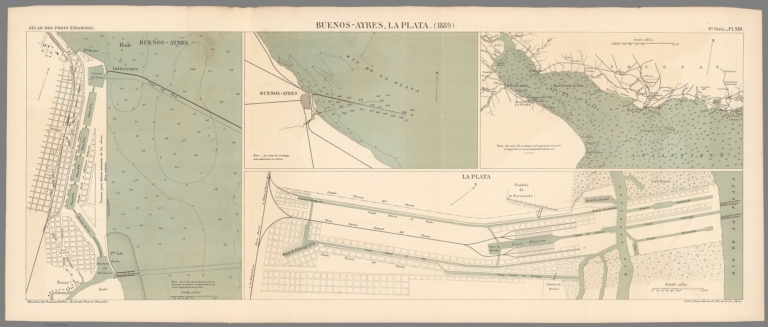
Full Title
Buenos-Ayres, La Plata. (1889) : Buenos-Ayres -- [Buenos-Ayres and vicinity] -- [Rio de La Plata] -- La Plata. 6e Série. Pl. XIII. Ministère des Travaux Publics. Ecole des Ponts et Chaussées. Lith. A. Simon, 13, R. du Val-de-Grâce. Paris.
List No
14306.156
Note
Four maps showing the ports of Buenos Aires and La Plata, Argentina, in 1889. Maps feature vegetation, railways, streets, bridges, drainage, docks and soundings, with depths given in meters. Three include a bar scale and all a compass rose, with north oriented toward top of sheet. Descriptive text throughout. Lithograph in black, white and blue. Together, maps are 28 x 75 cm, on sheet 33 x 79 cm. Bookplate title pasted to verso: Pl. XIII. Buenos-Ayres, La Plata. Appears in Sixième livraison.
Author
[Commercial Club of Chicago. Civic Committee, Burnham, Daniel Hudson, 1846-1912, Bennett, Edward H. (Edward Herbert), 1874-1954, Moore, Charles]
Full Title
XVII. The transformation of Paris under Haussmann : Plan showing the portion executed from 1854 to 1889.
List No
14346.023
Note
Map of Paris within second chapter to Plan of Chicago. Shows roads, parks and vicinity. Includes a bar scale. Other title at upper left of map: Paris - 1854-1889. With descriptive text: The new boulevards and streets are shown in yellow outlined with red. Colored engraving. Map is 15 x 20 cm, on sheet 24 x 31 cm. (Page number inferred.) Chapter spans pages 9-30.
Author
[United States. Naval Oceanographic Office, United States. Department of the Navy. Bureau of Navigation, Hayden, Edward Everett, 1858-1932, Bartlett, J. R.]
Full Title
Waterspouts off the Atlantic coast of the United States. -- January and February, 1888 : Waterspouts in the western portion of the North Atlantic during January and February, 1888, with tracks of storms coincident with some of them. Supplement to the Pilot Chart of the North Atlantic Ocean for March, 1888. Everett Hayden, Division of Marine Meteorology. D.C. J. R. Bartlett, Commander, U.S.N. Hydrographer to the Bureau of Navigation.
List No
14388.017
Note
Nautical chart of the North Atlantic Ocean representing January and February, 1888. Shows cities, coastlines, islands and sailing routes. Includes latitudinal and longitudinal lines. Indexed to indicate different steamships. Surrounded by descriptive text in the margins, authored by Everett Hayden. Black and white lithograph. Chart is 22 x 21 cm, on sheet 40 x 53 cm.
Author
[United States. Naval Oceanographic Office, United States. Department of the Navy. Bureau of Navigation, Hayden, Edward Everett, 1858-1932, Bartlett, J. R.]
Full Title
Pilot chart of the North Atlantic Ocean : March, 1888. Division of Meteorology, Everett Hayden. Published monthly at Hydrographic Office, Navy Department, Washington, D.C. J. R. Bartlett, Commander, U.S.N. Hydrographer to the Bureau of Navigation.
List No
14388.018
Note
Nautical chart of the North Atlantic Ocean representing March, 1888. Shows cities, coastlines, shoals, depths, islands, sailing routes, ocean currents, storm tracks, fog belts, equatorial rains, wind force and directions, as well as ice fields, icebergs and the limits of ice coverage. Includes latitudinal and longitudinal lines, a legend and compass rose with north oriented toward top of sheet. Descriptive text throughout, such as reports on weather and barometric pressure. Colored lithograph, with infographics overlaid upon geography. Chart is 53 x 75 cm, on double sheet 60 x 82 cm. "The variation is for 1885."
Author
[United States. Naval Oceanographic Office, United States. Department of the Navy. Bureau of Navigation, Hayden, Edward Everett, 1858-1932, Bartlett, J. R.]
Full Title
Pilot chart of the North Atlantic Ocean : April, 1888. Division of Meteorology, Everett Hayden. Published monthly at Hydrographic Office, Navy Department, Washington, D.C. J. R. Bartlett, Commander, U.S.N. Hydrographer to the Bureau of Navigation.
List No
14388.019
Note
Nautical chart of the North Atlantic Ocean representing April, 1888. Shows cities, coastlines, shoals, depths, islands, sailing routes, ocean currents, storm tracks, fog belts, equatorial rains, wind force and directions, as well as ice fields, icebergs and the limits of ice coverage. Includes latitudinal and longitudinal lines, a legend and compass rose with north oriented toward top of sheet. Descriptive text throughout, such as reports on weather and barometric pressure. Colored lithograph, with infographics overlaid upon geography. Chart is 53 x 75 cm, on double sheet 60 x 82 cm. "The variation is for 1885."
Author
[United States. Naval Oceanographic Office, United States. Department of the Navy. Bureau of Navigation, Hayden, Edward Everett, 1858-1932, Bartlett, J. R.]
Full Title
Pilot chart of the North Atlantic Ocean : May, 1888. Division of Meteorology, Everett Hayden. Published monthly at Hydrographic Office, Navy Department, Washington, D.C. J. R. Bartlett, Commander, U.S.N. Hydrographer to the Bureau of Navigation.
List No
14388.020
Note
Nautical chart of the North Atlantic Ocean representing May, 1888. Shows cities, coastlines, shoals, depths, islands, sailing routes, ocean currents, storm tracks, fog belts, equatorial rains, wind force and directions, as well as ice fields, icebergs and the limits of ice coverage. Includes latitudinal and longitudinal lines, a legend and compass rose with north oriented toward top of sheet. Descriptive text throughout, such as reports on weather and barometric pressure. Colored lithograph, with infographics overlaid upon geography. Chart is 53 x 75 cm, on double sheet 60 x 82 cm. "The variation is for 1885."
Author
[United States. Naval Oceanographic Office, United States. Department of the Navy. Bureau of Navigation, Hayden, Edward Everett, 1858-1932, Bartlett, J. R.]
Full Title
Pilot chart of the North Atlantic Ocean : June, 1888. Division of Meteorology, Everett Hayden. Published monthly at Hydrographic Office, Navy Department, Washington, D.C. J. R. Bartlett, Commander, U.S.N. Hydrographer to the Bureau of Navigation.
List No
14388.021
Note
Nautical chart of the North Atlantic Ocean representing June, 1888. Shows cities, coastlines, shoals, depths, islands, sailing routes, ocean currents, storm tracks, fog belts, equatorial rains, wind force and directions, as well as ice fields, icebergs and the limits of ice coverage. Includes latitudinal and longitudinal lines, a legend and compass rose with north oriented toward top of sheet. Descriptive text throughout, such as reports on weather and barometric pressure. Colored lithograph, with infographics overlaid upon geography. Chart is 53 x 75 cm, on double sheet 60 x 82 cm. "The variation is for 1885."
Author
[United States. Naval Oceanographic Office, United States. Department of the Navy. Bureau of Navigation, Hayden, Edward Everett, 1858-1932, Dyer, George L., 1849-1914, 1849-1914]
Full Title
Pilot chart of the North Atlantic Ocean : July, 1888. Division of Meteorology, Everett Hayden. Published monthly at Hydrographic Office, Navy Department, Washington, D.C. G. L. Dyer, Commander, U.S.N. Hydrographer to the Bureau of Navigation.
List No
14388.022
Note
Nautical chart of the North Atlantic Ocean representing July, 1888. Shows cities, coastlines, shoals, depths, islands, sailing routes, ocean currents, storm tracks, fog belts, equatorial rains, wind force and directions, as well as ice fields, icebergs and the limits of ice coverage. Includes latitudinal and longitudinal lines, a legend and compass rose with north oriented toward top of sheet. Descriptive text throughout, such as reports on weather and barometric pressure. Colored lithograph, with infographics overlaid upon geography. Chart is 53 x 75 cm, on double sheet 60 x 82 cm. "The variation is for 1885."
Author
[United States. Naval Oceanographic Office, United States. Department of the Navy. Bureau of Navigation, Hayden, Edward Everett, 1858-1932, Dyer, George L., 1849-1914, 1849-1914]
Full Title
Pilot chart of the North Atlantic Ocean : August, 1888. Division of Meteorology, Everett Hayden. Published monthly at Hydrographic Office, Navy Department, Washington, D.C. G. L. Dyer, Commander, U.S.N. Hydrographer to the Bureau of Navigation.
List No
14388.023
Note
Nautical chart of the North Atlantic Ocean representing August, 1888. Shows cities, coastlines, shoals, depths, islands, sailing routes, ocean currents, storm tracks, fog belts, equatorial rains, wind force and directions, as well as ice fields, icebergs and the limits of ice coverage. Includes latitudinal and longitudinal lines, a legend and compass rose with north oriented toward top of sheet. Descriptive text throughout, such as reports on weather, derelicts and hurricanes. Colored lithograph, with infographics overlaid upon geography. Chart is 53 x 75 cm, on double sheet 60 x 82 cm. "The variation is for 1885."
Author
[United States. Naval Oceanographic Office, United States. Department of the Navy. Bureau of Navigation, Hayden, Edward Everett, 1858-1932, Dyer, George L., 1849-1914, 1849-1914]
Full Title
Pilot chart of the North Atlantic Ocean : Supplement to the Chart for August, 1888. Division of Meteorology, Everett Hayden. Published monthly at Hydrographic Office, Navy Department, Washington, D.C. G. L. Dyer, Commander, U.S.N. Hydrographer to the Bureau of Navigation.
List No
14388.024
Note
Nautical chart of the North Atlantic Ocean representing supplemental information for August, 1888. Shows cities, coastlines, shoals, depths, islands, sailing routes, ocean currents, storm tracks, fog belts, equatorial rains, wind force and directions, as well as ice fields, icebergs and the limits of ice coverage. Includes latitudinal and longitudinal lines, a legend and compass rose with north oriented toward top of sheet. Descriptive text throughout, such as reports on weather and timber vessels. Colored lithograph, with infographics overlaid upon geography. Chart is 53 x 75 cm, on double sheet 60 x 82 cm. "The variation is for 1885."
Author
[United States. Naval Oceanographic Office, United States. Department of the Navy. Bureau of Navigation, Hayden, Edward Everett, 1858-1932, Dyer, George L., 1849-1914, 1849-1914]
Full Title
Pilot chart of the North Atlantic Ocean : September, 1888. Division of Meteorology, Everett Hayden. Published monthly at Hydrographic Office, Navy Department, Washington, D.C. G. L. Dyer, Commander, U.S.N. Hydrographer to the Bureau of Navigation.
List No
14388.025
Note
Nautical chart of the North Atlantic Ocean representing September, 1888. Shows cities, coastlines, shoals, depths, islands, sailing routes, ocean currents, storm tracks, fog belts, equatorial rains, wind force and directions, as well as ice fields, icebergs and the limits of ice coverage. Includes latitudinal and longitudinal lines, a legend and compass rose with north oriented toward top of sheet. Descriptive text throughout, such as reports on weather and timber vessels. Colored lithograph, with infographics overlaid upon geography. Chart is 53 x 75 cm, on double sheet 60 x 82 cm. "The variation is for 1885."
Author
[United States. Naval Oceanographic Office, United States. Department of the Navy. Bureau of Navigation, Hayden, Edward Everett, 1858-1932, Dyer, George L., 1849-1914, 1849-1914]
Full Title
Pilot chart of the North Atlantic Ocean : October, 1888. Division of Meteorology, Everett Hayden. Published monthly at Hydrographic Office, Navy Department, Washington, D.C. G. L. Dyer, Commander, U.S.N. Hydrographer to the Bureau of Navigation.
List No
14388.026
Note
Nautical chart of the North Atlantic Ocean representing October, 1888. Shows cities, coastlines, shoals, depths, islands, sailing routes, ocean currents, storm tracks, fog belts, equatorial rains, wind force and directions, as well as ice fields, icebergs and the limits of ice coverage. Includes latitudinal and longitudinal lines, a legend and compass rose with north oriented toward top of sheet. Descriptive text throughout, such as reports on weather and barometric pressure. Colored lithograph, with infographics overlaid upon geography. Chart is 53 x 75 cm, on double sheet 60 x 82 cm. "The variation is for 1885."
Author
[United States. Naval Oceanographic Office, United States. Department of the Navy. Bureau of Navigation, Hayden, Edward Everett, 1858-1932, Dyer, George L., 1849-1914, 1849-1914]
Full Title
Pilot chart of the North Atlantic Ocean : November, 1888. Division of Meteorology, Everett Hayden. Published monthly at Hydrographic Office, Navy Department, Washington, D.C. G. L. Dyer, Commander, U.S.N. Hydrographer to the Bureau of Navigation.
List No
14388.027
Note
Nautical chart of the North Atlantic Ocean representing November, 1888. Shows cities, coastlines, shoals, depths, islands, sailing routes, ocean currents, storm tracks, fog belts, equatorial rains, wind force and directions, as well as ice fields, icebergs and the limits of ice coverage. Includes latitudinal and longitudinal lines, a legend and compass rose with north oriented toward top of sheet. Descriptive text throughout, such as reports on weather and barometric pressure. Colored lithograph, with infographics overlaid upon geography. Chart is 53 x 75 cm, on double sheet 60 x 82 cm. "The variation is for 1885."
Author
[United States. Naval Oceanographic Office, United States. Department of the Navy. Bureau of Navigation, Hayden, Edward Everett, 1858-1932, Dyer, George L., 1849-1914, 1849-1914]
Full Title
Pilot chart of the North Atlantic Ocean : December, 1888. Division of Meteorology, Everett Hayden. Published monthly at Hydrographic Office, Navy Department, Washington, D.C. G. L. Dyer, Commander, U.S.N. Hydrographer to the Bureau of Navigation.
List No
14388.028
Note
Nautical chart of the North Atlantic Ocean representing December, 1888. Shows cities, coastlines, shoals, depths, islands, sailing routes, ocean currents, storm tracks, fog belts, equatorial rains, wind force and directions, as well as ice fields, icebergs and the limits of ice coverage. Includes latitudinal and longitudinal lines, a legend and compass rose with north oriented toward top of sheet. Descriptive text throughout, such as reports on weather and barometric pressure. Colored lithograph, with infographics overlaid upon geography. Chart is 53 x 75 cm, on double sheet 60 x 82 cm. "The variation is for 1885."
Author
[United States. Naval Oceanographic Office, United States. Department of the Navy. Bureau of Navigation, Hayden, Edward Everett, 1858-1932, Dyer, George L., 1849-1914, 1849-1914]
Full Title
Pilot chart of the North Atlantic Ocean : January, 1889. Division of Meteorology, Everett Hayden. Published monthly at Hydrographic Office, Navy Department, Washington, D.C. G. L. Dyer, Commander, U.S.N. Hydrographer to the Bureau of Navigation.
List No
14388.029
Note
Nautical chart of the North Atlantic Ocean representing January, 1889. Shows cities, coastlines, shoals, depths, islands, sailing routes, ocean currents, storm tracks, fog belts, equatorial rains, wind force and directions, as well as ice fields, icebergs and the limits of ice coverage. Includes latitudinal and longitudinal lines, a legend and compass rose with north oriented toward top of sheet. Descriptive text throughout, such as reports on weather and barometric pressure. Colored lithograph, with infographics overlaid upon geography. Chart is 53 x 75 cm, on double sheet 60 x 82 cm. "The variation is for 1885."
Author
[United States. Naval Oceanographic Office, United States. Department of the Navy. Bureau of Navigation, Hayden, Edward Everett, 1858-1932, Dyer, George L., 1849-1914, 1849-1914]
Full Title
Pilot chart of the North Atlantic Ocean : February, 1889. Division of Meteorology, Everett Hayden. Published monthly at Hydrographic Office, Navy Department, Washington, D.C. G. L. Dyer, Commander, U.S.N. Hydrographer to the Bureau of Navigation.
List No
14388.030
Note
Nautical chart of the North Atlantic Ocean representing February, 1889. Shows cities, coastlines, shoals, depths, islands, sailing routes, ocean currents, storm tracks, fog belts, equatorial rains, wind force and directions, as well as ice fields, icebergs and the limits of ice coverage. Includes latitudinal and longitudinal lines, a legend and compass rose with north oriented toward top of sheet. Descriptive text throughout, such as reports on weather and barometric pressure. Colored lithograph, with infographics overlaid upon geography. Chart is 53 x 75 cm, on double sheet 60 x 82 cm. "The variation is for 1885."
Author
[United States. Naval Oceanographic Office, United States. Department of the Navy. Bureau of Navigation, Hayden, Edward Everett, 1858-1932, Dyer, George L., 1849-1914]
Full Title
The derelict American schooner "W. L. White." : Together with the tracks of three other notable derelicts and the general drift of ocean currents. Supplement to the Pilot Chart of the North Atlantic Ocean for February, 1889. Everett Hayden, Division of Marine Meteorology. George. L. Dyer, Lieutenant, U.S.N. Hydrographer to Bureau of Navigation. N. Peters, Photo-Lithographer Washington, D. C.
List No
14388.031
Note
Nautical chart of the North Atlantic Ocean representing the derelict American schooner "W. L. White" in February, 1889. Shows cities, coastlines, islands, ocean currents and sailing routes. Includes latitudinal and longitudinal lines. Surrounded by descriptive text in the margins, authored by Everett Hayden. Black and white lithograph. Chart is 35 x 42 cm, on sheet 42 x 51 cm.
Author
[United States. Naval Oceanographic Office, United States. Department of the Navy. Bureau of Navigation, Hayden, Edward Everett, 1858-1932, Dyer, George L., 1849-1914]
Full Title
Pilot chart of the North Atlantic Ocean : March, 1889. Division of Meteorology, Everett Hayden. Published monthly at Hydrographic Office, Navy Department, Washington, D.C. G. L. Dyer, Commander, U.S.N. Hydrographer to the Bureau of Navigation.
List No
14388.032
Note
Nautical chart of the North Atlantic Ocean representing March, 1889. Shows cities, coastlines, shoals, depths, islands, sailing routes, ocean currents, storm tracks, fog belts, equatorial rains, wind force and directions, as well as ice fields, icebergs and the limits of ice coverage. Includes latitudinal and longitudinal lines, a legend and compass rose with north oriented toward top of sheet. Descriptive text throughout, such as reports on weather, barometric pressure, collisions with derelicts and the Gulf Stream. Inset: Storm signals, Atlantic and Gulf Coast of the United States. Colored lithograph, with infographics overlaid upon geography. Chart is 53 x 75 cm, on double sheet 60 x 82 cm. "The variation is for 1885."
Author
[United States. Naval Oceanographic Office, United States. Department of the Navy. Bureau of Navigation, Hayden, Edward Everett, 1858-1932, Dyer, George L., 1849-1914]
Full Title
Pilot chart of the North Atlantic Ocean : April, 1889. Division of Meteorology, Everett Hayden. Published monthly at Hydrographic Office, Navy Department, Washington, D.C. G. L. Dyer, Commander, U.S.N. Hydrographer to the Bureau of Navigation.
List No
14388.033
Note
Nautical chart of the North Atlantic Ocean representing April, 1889. Shows cities, coastlines, shoals, depths, islands, sailing routes, ocean currents, storm tracks, fog belts, equatorial rains, wind force and directions, as well as ice fields, icebergs and the limits of ice coverage. Includes latitudinal and longitudinal lines, a legend and compass rose with north oriented toward top of sheet. Descriptive text throughout, such as reports on weather, barometric pressure, whirlwinds, waterspouts, tornadoes, ocean currents and storm signals. Insets: Telegraph chart of the Bay of North America -- Storm signals, Atlantic and Gulf Coast of the United States. Colored lithograph, with infographics overlaid upon geography. Chart is 53 x 75 cm, on double sheet 60 x 82 cm. "The variation is for 1888."
Author
[United States. Naval Oceanographic Office, United States. Department of the Navy. Bureau of Navigation, Hayden, Edward Everett, 1858-1932, Dyer, George L., 1849-1914]
Full Title
Pilot chart of the North Atlantic Ocean : May, 1889. Division of Meteorology, Everett Hayden. Published monthly at Hydrographic Office, Navy Department, Washington, D.C. G. L. Dyer, Commander, U.S.N. Hydrographer to the Bureau of Navigation.
List No
14388.034
Note
Nautical chart of the North Atlantic Ocean representing May, 1889. Shows cities, coastlines, shoals, depths, islands, sailing routes, ocean currents, storm tracks, fog belts, equatorial rains, wind force and directions, as well as ice fields, icebergs and the limits of ice coverage. Includes latitudinal and longitudinal lines, a legend and compass rose with north oriented toward top of sheet. Descriptive text throughout, such as reports on weather, barometric pressure, ocean currents and storm signals. Insets: Hurricane chart of the Bay of North America -- Storm signals, Atlantic and Gulf Coast of the United States. Colored lithograph, with infographics overlaid upon geography. Chart is 53 x 75 cm, on double sheet 60 x 82 cm. "The variation is for 1888."
Author
[United States. Naval Oceanographic Office, United States. Department of the Navy. Bureau of Navigation, Witzel, H. M. (Horace Mark), 1858-1927, Hayden, Edward Everett, 1858-1932, Dyer, George L., 1849-1914, 1849-1914]
Full Title
Pilot chart of the North Atlantic Ocean : June, 1889. Division of Meteorology, H. M. Witzel, Lieut., U.S.N. Marine Meteorologist, Everett Hayden. Published monthly at Hydrographic Office, Navy Department, Washington, D.C. G. L. Dyer, Commander, U.S.N. Hydrographer to the Bureau of Navigation.
List No
14388.035
Note
Nautical chart of the North Atlantic Ocean representing June, 1889. Shows cities, coastlines, shoals, depths, islands, sailing routes, ocean currents, storm tracks, fog belts, equatorial rains, wind force and directions, as well as ice fields, icebergs and the limits of ice coverage. Includes latitudinal and longitudinal lines, a legend and compass rose with north oriented toward top of sheet. Descriptive text throughout, such as reports on weather, barometric pressure, hurricanes, waterspouts, derelict schooners and ocean currents. Insets: West Indian hurricanes : Diagram No. 1 -- Diagram No. 2 -- Diagram No. 3. Colored lithograph, with infographics overlaid upon geography. Chart is 53 x 75 cm, on double sheet 60 x 82 cm. "The variation is for 1888."
Author
[United States. Naval Oceanographic Office, United States. Department of the Navy. Bureau of Navigation, Witzel, H. M. (Horace Mark), 1858-1927, Hayden, Edward Everett, 1858-1932, Dyer, George L., 1849-1914, 1849-1914]
Full Title
Pilot chart of the North Atlantic Ocean : July, 1889. Division of Marine Meteorology, H. M. Witzel, Lieut. U.S.N. Marine Meteorologist, Everett Hayden. Published monthly at Hydrographic Office, Navy Department, Washington, D.C. G. L. Dyer, Lieut., U.S.N. Hydrographer to the Bureau of Navigation.
List No
14388.036
Note
Nautical chart of the North Atlantic Ocean representing July, 1889. Shows cities, coastlines, shoals, depths, islands, sailing routes, ocean currents, storm tracks, fog belts, equatorial rains, wind force and directions, as well as ice fields, icebergs and the limits of ice coverage. Includes latitudinal and longitudinal lines, a legend and compass rose with north oriented toward top of sheet. Descriptive text throughout, such as reports on weather, barometric pressure, the Gulf Stream, derelicts in the North Atlantic, hurricanes, ice on transatlantic routes and storm signals. Insets: North Atlantic storms : June and October, lat. 23° to 55° ... -- June and October, lat. 20° to 23° -- June and October, lat. 10° to 20° -- Storm signals, Atlantic and Gulf Coast of the United States. Colored lithograph, with infographics overlaid upon geography. Chart is 53 x 75 cm, on double sheet 60 x 82 cm. "The variation is for 1888."
Author
[United States. Naval Oceanographic Office, United States. Department of the Navy. Bureau of Navigation, Witzel, H. M. (Horace Mark), 1858-1927, Hayden, Edward Everett, 1858-1932, Dyer, George L., 1849-1914, 1849-1914]
Full Title
Pilot chart of the North Atlantic Ocean : August, 1889. Division of Marine Meteorology, H. M. Witzel, Lieut. U.S.N. Marine Meteorologist, Everett Hayden. Published monthly at Hydrographic Office, Navy Department, Washington, D.C. G. L. Dyer, Lieut., U.S.N. Hydrographer to the Bureau of Navigation.
List No
14388.037
Note
Nautical chart of the North Atlantic Ocean representing August, 1889. Shows cities, coastlines, shoals, depths, islands, sailing routes, ocean currents, storm tracks, fog belts, equatorial rains, wind force and directions, as well as ice fields, icebergs and the limits of ice coverage. Includes latitudinal and longitudinal lines, a legend and compass rose with north oriented toward top of sheet. Descriptive text throughout, such as reports on weather, barometric pressure, ocean currents, derelicts, hurricanes and storm signals. Insets: North Atlantic storms : June and October, lat. 23° to 55° ... -- June and October, lat. 20° to 23° -- June and October, lat. 10° to 20° -- Storm signals, Atlantic and Gulf Coast of the United States. Colored lithograph, with infographics overlaid upon geography. Chart is 53 x 75 cm, on double sheet 60 x 82 cm. "The variation is for 1888."
Author
[United States. Naval Oceanographic Office, United States. Department of the Navy. Bureau of Navigation, Witzel, H. M. (Horace Mark), 1858-1927, Hayden, Edward Everett, 1858-1932, Dyer, George L., 1849-1914, 1849-1914]
Full Title
Pilot chart of the North Atlantic Ocean : September, 1889. Division of Marine Meteorology, H. M. Witzel, Lieut. U.S.N. Marine Meteorologist, Everett Hayden. Published monthly at Hydrographic Office, Navy Department, Washington, D.C. G. L. Dyer, Lieut., U.S.N. Hydrographer to the Bureau of Navigation.
List No
14388.038
Note
Nautical chart of the North Atlantic Ocean representing September, 1889. Shows cities, coastlines, shoals, depths, islands, sailing routes, ocean currents, storm tracks, fog belts, equatorial rains, wind force and directions, as well as ice fields, icebergs and the limits of ice coverage. Includes latitudinal and longitudinal lines, a legend and compass rose with north oriented toward top of sheet. Descriptive text throughout, such as reports on weather, barometric pressure, hurricanes, ocean currents, storm signals and dangers to navigation. Insets: North Atlantic storms : June and October, lat. 23° to 55° ... -- June and October, lat. 20° to 23° -- June and October, lat. 10° to 20° -- Storm signals, Atlantic and Gulf Coast of the United States. Colored lithograph, with infographics overlaid upon geography. Chart is 53 x 75 cm, on double sheet 60 x 82 cm. "The variation is for 1888."
Author
[United States. Naval Oceanographic Office, United States. Department of the Navy. Bureau of Navigation, Witzel, H. M. (Horace Mark), 1858-1927, Hayden, Edward Everett, 1858-1932, Dyer, George L., 1849-1914, 1849-1914]
Full Title
The St. Thomas-Hatteras Hurricane of September 3-12, 1889. Supplement to the Pilot Chart of the North Atlantic Ocean for October, 1889. Date of publication, September 27. Division of Marine Meteorology, H. M. Witzel, Lieut. U.S.N. Marine Meteorologist, Everett Hayden. George L. Dyer, Lieutenant, U.S.N., Hydrographer.
List No
14388.039
Note
Ten nautical charts of the North Atlantic Ocean representing the St. Thomas-Hatteras Hurricane, with one chart per day from September 3 to 12, 1889. Charts show cities, coastlines, islands, ocean currents and wind. Features a list of vessels from which sailing reports were received during the period of the hurricane. Charts include latitudinal and longitudinal lines. With a legend pertaining to all charts, and descriptive text accompanying each chart. Black and white lithograph. Together, charts are 35 x 76 cm, on double sheet 58 x 83 cm.
Author
[United States. Naval Oceanographic Office, United States. Department of the Navy. Bureau of Navigation, Witzel, H. M. (Horace Mark), 1858-1927, Hayden, Edward Everett, 1858-1932, Dyer, George L., 1849-1914, 1849-1914]
Full Title
Pilot chart of the North Atlantic Ocean : October, 1889. Division of Marine Meteorology, H. M. Witzel, Lieut. U.S.N. Marine Meteorologist, Everett Hayden. Published monthly at Hydrographic Office, Navy Department, Washington, D.C. G. L. Dyer, Lieut., U.S.N. Hydrographer to the Bureau of Navigation.
List No
14388.040
Note
Nautical chart of the North Atlantic Ocean representing October, 1889. Shows cities, coastlines, shoals, depths, islands, sailing routes, ocean currents, storm tracks, fog belts, equatorial rains, wind force and directions, as well as ice fields, icebergs and the limits of ice coverage. Includes latitudinal and longitudinal lines, a legend and compass rose with north oriented toward top of sheet. Descriptive text throughout, such as reports on weather, barometric pressure, hurricanes, the use of oil, storm signals and ocean currents. Insets: North Atlantic storms : June and October, lat. 23° to 55° ... -- June and October, lat. 20° to 23° -- June and October, lat. 10° to 20° -- Storm signals, Atlantic and Gulf Coast of the United States. Colored lithograph, with infographics overlaid upon geography. Chart is 53 x 75 cm, on double sheet 60 x 82 cm. "The variation is for 1888."
Author
[United States. Naval Oceanographic Office, United States. Department of the Navy. Bureau of Navigation, Witzel, H. M. (Horace Mark), 1858-1927, Hayden, Edward Everett, 1858-1932, Dyer, George L., 1849-1914, 1849-1914]
Full Title
Pilot chart of the North Atlantic Ocean : November, 1889. Division of Marine Meteorology, H. M. Witzel, Lieut. U.S.N. Marine Meteorologist, Everett Hayden. Published monthly at Hydrographic Office, Navy Department, Washington, D.C. G. L. Dyer, Lieut., U.S.N. Hydrographer to the Bureau of Navigation.
List No
14388.041
Note
Nautical chart of the North Atlantic Ocean representing November, 1889. Shows cities, coastlines, shoals, depths, islands, sailing routes, ocean currents, storm tracks, fog belts, equatorial rains, wind force and directions, as well as ice fields, icebergs and the limits of ice coverage. Includes latitudinal and longitudinal lines, a legend and compass rose with north oriented toward top of sheet. Descriptive text throughout, such as reports on weather, barometric pressure, waterspouts, the use of oil and storm signals. Insets: North Atlantic storms : June and October, lat. 23° to 55° ... -- June and October, lat. 20° to 23° -- June and October, lat. 10° to 20° -- Storm signals, Atlantic and Gulf Coast of the United States. Colored lithograph, with infographics overlaid upon geography. Chart is 53 x 75 cm, on double sheet 60 x 82 cm. "The variation is for 1888."
Author
[United States. Naval Oceanographic Office, United States. Department of the Navy. Bureau of Navigation, Witzel, H. M. (Horace Mark), 1858-1927, Hayden, Edward Everett, 1858-1932, Picking, Henry F. (Henry Forry), 1840-1899]
Full Title
Pilot chart of the North Atlantic Ocean : December, 1889. Division of Marine Meteorology, H. M. Witzel, Lieut. U.S.N. Marine Meteorologist, Everett Hayden. Published monthly at Hydrographic Office, Navy Department, Washington, D.C. Henry F. Picking, Captain, U.S.N. Hydrographer.
List No
14388.042
Note
Nautical chart of the North Atlantic Ocean representing December, 1889. Shows cities, coastlines, shoals, depths, islands, sailing routes, ocean currents, storm tracks, fog belts, equatorial rains, wind force and directions, as well as ice fields, icebergs and the limits of ice coverage. Includes latitudinal and longitudinal lines, a legend and compass rose with north oriented toward top of sheet. Descriptive text throughout, such as reports on weather, barometric pressure, the total solar eclipse of December 22, 1889, drifting buoys, the removal of dangerous derelicts and storm signals. Insets: North Atlantic storms : June and October, lat. 23° to 55° ... -- June and October, lat. 20° to 23° -- June and October, lat. 10° to 20° -- Storm signals, Atlantic and Gulf Coast of the United States. Colored lithograph, with infographics overlaid upon geography. Chart is 53 x 75 cm, on double sheet 60 x 82 cm. "The variation is for 1888."
Author
[FESCA, Max (1846-1917), HARADA, Toyokichi (1860 - 1894), 農商務省地質局 / NŌSHŌMUSHŌ CHISHITSUKYOKU / GEOLOGICAL BUREAU, MINISTRY OF AGRICULTURE AND COMMERCE]]
Full Title
XV. Cotton Production (Kuamme per Square Ri).
List No
15441.017
Author
[FESCA, Max (1846-1917), HARADA, Toyokichi (1860 - 1894), 農商務省地質局 / NŌSHŌMUSHŌ CHISHITSUKYOKU / GEOLOGICAL BUREAU, MINISTRY OF AGRICULTURE AND COMMERCE]]
Full Title
XVI. Hemp Production (Kuamme per Square Ri).
List No
15441.018
Author
[FESCA, Max (1846-1917), HARADA, Toyokichi (1860 - 1894), 農商務省地質局 / NŌSHŌMUSHŌ CHISHITSUKYOKU / GEOLOGICAL BUREAU, MINISTRY OF AGRICULTURE AND COMMERCE]]
Full Title
XVII. Tea Production (Kuamme per Square Ri).
List No
15441.019
Author
[FESCA, Max (1846-1917), HARADA, Toyokichi (1860 - 1894), 農商務省地質局 / NŌSHŌMUSHŌ CHISHITSUKYOKU / GEOLOGICAL BUREAU, MINISTRY OF AGRICULTURE AND COMMERCE]]
Full Title
XVIII. Cotton Production (Koku per Square Ri).
List No
15441.020
Author
[FESCA, Max (1846-1917), HARADA, Toyokichi (1860 - 1894), 農商務省地質局 / NŌSHŌMUSHŌ CHISHITSUKYOKU / GEOLOGICAL BUREAU, MINISTRY OF AGRICULTURE AND COMMERCE]]
Full Title
XIX. Raw Silk Production (Koku per Square Ri).
List No
15441.021
Author
[FESCA, Max (1846-1917), HARADA, Toyokichi (1860 - 1894), 農商務省地質局 / NŌSHŌMUSHŌ CHISHITSUKYOKU / GEOLOGICAL BUREAU, MINISTRY OF AGRICULTURE AND COMMERCE]]
Full Title
XX. Horses (Per Square Ri).
List No
15441.022
Author
[FESCA, Max (1846-1917), HARADA, Toyokichi (1860 - 1894), 農商務省地質局 / NŌSHŌMUSHŌ CHISHITSUKYOKU / GEOLOGICAL BUREAU, MINISTRY OF AGRICULTURE AND COMMERCE]]
Full Title
XXI. Cattle (Per Square Ri).
List No
15441.023
Author
[FESCA, Max (1846-1917), HARADA, Toyokichi (1860 - 1894), 農商務省地質局 / NŌSHŌMUSHŌ CHISHITSUKYOKU / GEOLOGICAL BUREAU, MINISTRY OF AGRICULTURE AND COMMERCE]]
Full Title
XXII. Farm Horses (per 100 cho Arable Land).
List No
15441.024
Author
[FESCA, Max (1846-1917), HARADA, Toyokichi (1860 - 1894), 農商務省地質局 / NŌSHŌMUSHŌ CHISHITSUKYOKU / GEOLOGICAL BUREAU, MINISTRY OF AGRICULTURE AND COMMERCE]]
Full Title
XXIII. Farm Cattle (per 100 cho Arable Land).
List No
15441.025
Author
[Gill, J.K., Galvani, W.H.]
Full Title
(Covers to) J.K. Gill & Cos. Map of Oregon. Portland Ogn. 1889. New Sectional Township & County Map Of Oregon. Published by J.K. Gill & Co. Booksellers and Stationers Portland, Oregon. Compiled and drawn from all United States and Railroad Surveys made previous to March 1st 1884 by W.H. Galvani, Civil Engineer, Portland Or. ... Entered ... 1889 by J.K. Gill & Co. ... Washington. Lith. by L.M. Snyder & Co. 79 Dearborn St. Chicago, Ill.
List No
1892.001
Note
Full color by county. Folded into dark brown cloth covers 16.5x10.6 with "Sectional Township And County Map Of Oregon. Published By J.K. Gill & Co. Portland, Oregon. 1889" stamped in black.
Author
[Galvani, W.H., Gill, J.K.]
Full Title
J.K. Gill & Cos. Map of Oregon. Portland Ogn. 1889. New Sectional Township & County Map Of Oregon. Published by J.K. Gill & Co. Booksellers and Stationers Portland, Oregon. Compiled and drawn from all United States and Railroad Surveys made previous to March 1st 1884 by W.H. Galvani, Civil Engineer, Portland Or. ... Entered ... 1889 by J.K. Gill & Co. ... Washington. Lith. by L.M. Snyder & Co. 79 Dearborn St. Chicago, Ill.
List No
1892.002
Note
Full color by county. Folded into dark brown cloth covers 16.5x10.6 with "Sectional Township And County Map Of Oregon. Published By J.K. Gill & Co. Portland, Oregon. 1889" stamped in black.
|