|
Author
[Pelet, Paul, 1849-1927, Challamel, Augustin, 1818-1894, Hausermann, R., active 1875-1915]
Full Title
Colonies Françaises. Nouvel atlas des colonies Françaises par Paul Pelet, 1889, No 1. A. Challamel, Éditeur, 5 rue Jacob, Paris. Gravé par R. Hausermann, Paris, Imp. Lemercier et Cie.
List No
14300.011
Note
World map showing French colonies around the world in 1889. Title translates to: French colonies. Features political boundaries, ocean transportation routes, telegraph and cable lines, as well as French consulates. Includes latitudinal and longitudinal lines and a legend. Colored lithograph. Map is 21 x 35 cm, on sheet 26 x 37 cm. Accompanied by descriptive text of the same title, on preceding pages in section I. In first part of atlas.
Author
[Pelet, Paul, 1849-1927, Challamel, Augustin, 1818-1894, Hausermann, R., active 1875-1915]
Full Title
Sénégal et Soudan. Nouvel atlas des colonies Françaises par Paul Pelet, 1889, No 6. A. Challamel, Éditeur, 5 rue Jacob, Paris. Gravé par R. Hausermann, Paris, Imp. Lemercier et Cie.
List No
14300.021
Note
Map of Senegal and Sudan, including the vicinity. Shows place names, transportation routes, topography, lakes, drainage, coastline and islands. Relief shown with hachures. Includes latitudinal and longitudinal lines, as well as a bar scale and a scale statement. With inset map: [Banc d'Arguin] [= Bay of Arguin]. Colored lithograph. Map is 21 x 34 cm, on sheet 26 x 37 cm. Accompanied by descriptive text of the same title, on preceding pages in section VI. In second part of atlas, Afrique.
Author
[Pelet, Paul, 1849-1927, Challamel, Augustin, 1818-1894, Hausermann, R., active 1875-1915]
Full Title
Soudan et Golfe de Guinée. Nouvel atlas des colonies Françaises par Paul Pelet, 1889, No 7. A. Challamel, Éditeur, 5 rue Jacob, Paris. Gravé par R. Hausermann, Paris, Imp. Lemercier et Cie.
List No
14300.024
Note
Map of Sudan and the Gulf of Guinea, including the vicinity. Shows place names, transportation routes, topography, drainage, coastline and water transportation routes. Relief shown with hachures. Includes latitudinal and longitudinal lines, as well as a bar scale and a scale statement. Colored lithograph. Map is 21 x 33 cm, on sheet 26 x 37 cm. Accompanied by descriptive text of the same title, on preceding pages in section VII. In second part of atlas, Afrique.
Author
[Pelet, Paul, 1849-1927, Challamel, Augustin, 1818-1894, Hausermann, R., active 1875-1915]
Full Title
Gabon-Congo. Nouvel atlas des colonies Françaises par Paul Pelet, 1889, No 8. A. Challamel, Éditeur, 5 rue Jacob, Paris. Gravé par R. Hausermann, Paris, Imp. Lemercier et Cie.
List No
14300.027
Note
Map of Gabon and the Congo, including the vicinity. Shows place names, transportation routes, topography, drainage, coastline and islands. Relief shown with hachures. Includes latitudinal and longitudinal lines, as well as a bar scale and a scale statement. Colored lithograph. Map is 21 x 32 cm, on sheet 26 x 37 cm. Accompanied by descriptive text of the same title, on preceding pages in section VIII. In second part of atlas, Afrique.
Author
[Pelet, Paul, 1849-1927, Challamel, Augustin, 1818-1894, Hausermann, R., active 1875-1915]
Full Title
Obock. Nouvel atlas des colonies Françaises par Paul Pelet, 1889, No 9. A. Challamel, Éditeur, 5 rue Jacob, Paris. Gravé par R. Hausermann, Paris, Imp. Lemercier et Cie.
List No
14300.029
Note
Map of Obock (Djibouti), including the vicinity. Shows place names, transportation routes, topography, drainage, coastline, islands and ports. Relief shown with hachures. Includes latitudinal and longitudinal lines, as well as a bar scale and a scale statement. Colored lithograph. Map is 21 x 32 cm, on sheet 26 x 37 cm. Accompanied by descriptive text of the same title, on preceding pages in section IX. In second part of atlas, Afrique.
Author
[Pelet, Paul, 1849-1927, Challamel, Augustin, 1818-1894, Hausermann, R., active 1875-1915]
Full Title
Madagascar. Nouvel atlas des colonies Françaises par Paul Pelet, 1889, No 10. A. Challamel, Éditeur, 5 rue Jacob, Paris. Gravé par R. Hausermann, Paris, Imp. Lemercier et Cie.
List No
14300.032
Note
Map of Madagascar, including the vicinity. Shows place names, transportation routes, topography, drainage, coastlines, islands and ports. Relief shown with hachures. Includes latitudinal and longitudinal lines, as well as a bar scale and a scale statement. Colored lithograph. Map is 33 x 25 cm, on sheet 37 x 26 cm. Accompanied by descriptive text of the same title, on preceding pages in section X. In third part of atlas, Océan Indien.
Author
[Pelet, Paul, 1849-1927, Challamel, Augustin, 1818-1894, Hausermann, R., active 1875-1915]
Full Title
Diego-Suarez, Nossi-Bé, Ste. Marie. Nouvel atlas des colonies Françaises par Paul Pelet, 1889, No 11. A. Challamel, Éditeur, 5 rue Jacob, Paris. Gravé par R. Hausermann, Paris, Imp. Lemercier et Cie.
List No
14300.035
Note
Map of Diego-Suarez [current-day Antsiranana], and the Nossi-Bé [Nosy-Be] and Sainte-Marie islands of Madagascar. Shows place names, transportation routes, topography, drainage, coastlines, islands and ports. Relief shown with hachures. Includes latitudinal and longitudinal lines, as well as a bar scale and a scale statement. Colored lithograph. Map appears in two parts, which, together, are 21 x 32 cm, on sheet 26 x 37 cm. Accompanied by descriptive text of the same title, on preceding pages in section XI. In third part of atlas, Océan Indien.
Author
[Pelet, Paul, 1849-1927, Challamel, Augustin, 1818-1894, Hausermann, R., active 1875-1915]
Full Title
Mayotte et les Comores. Nouvel atlas des colonies Françaises par Paul Pelet, 1889, No 12. A. Challamel, Éditeur, 5 rue Jacob, Paris. Gravé par R. Hausermann, Paris, Imp. Lemercier et Cie.
List No
14300.038
Note
Map of Mayotte and the Comoros. Shows place names, transportation routes, topography, drainage, coastlines, islands and ports. Relief shown with hachures. Includes latitudinal and longitudinal lines, as well as a bar scale and a scale statement. Colored lithograph. Map is 21 x 32 cm, on sheet 26 x 37 cm. Accompanied by descriptive text of the same title, on preceding pages in section XII. In third part of atlas, Océan Indien.
Author
[Pelet, Paul, 1849-1927, Challamel, Augustin, 1818-1894, Hausermann, R., active 1875-1915]
Full Title
La Réunion et Maurice, Kerguelen. Nouvel atlas des colonies Françaises par Paul Pelet, 1889, No 13. A. Challamel, Éditeur, 5 rue Jacob, Paris. Gravé par R. Hausermann, Paris, Imp. Lemercier et Cie.
List No
14300.041
Note
Map of Réunion, Mauritius and the Kerguelen Islands. Shows place names, transportation routes, topography, drainage, coastlines, islands and ports. Relief shown with hachures. Includes latitudinal and longitudinal lines, as well as a bar scale and a scale statement. Colored lithograph. Map appears in two parts, which, together, are 21 x 32 cm, on sheet 26 x 37 cm. Accompanied by descriptive text of the same title, on preceding pages in section XIII. In third part of atlas, Océan Indien.
Author
[Pelet, Paul, 1849-1927, Challamel, Augustin, 1818-1894, Hausermann, R., active 1875-1915]
Full Title
Inde. Nouvel atlas des colonies Françaises par Paul Pelet, 1889, No 14. A. Challamel, Éditeur, 5 rue Jacob, Paris. Gravé par R. Hausermann, Paris, Imp. Lemercier et Cie.
List No
14300.044
Note
Map of India and the vicinity. Shows place names, transportation routes, topography, lakes, drainage, coastlines, islands and ports. Relief shown with hachures. Includes latitudinal and longitudinal lines, as well as a bar scale and a scale statement. With inset map [India and greater vicinity]. Colored lithograph. Map appears in two parts, which, together, are 32 x 22 cm, on sheet 37 x 26 cm. Accompanied by descriptive text of the same title, on preceding pages in section XIV. In third part of atlas, Océan Indien.
Author
[Pelet, Paul, 1849-1927, Challamel, Augustin, 1818-1894, Hausermann, R., active 1875-1915]
Full Title
Indochine. Nouvel atlas des colonies Françaises par Paul Pelet, 1889, No 15. A. Challamel, Éditeur, 5 rue Jacob, Paris. Gravé par R. Hausermann, Paris, Imp. Lemercier et Cie.
List No
14300.048
Note
Map of Indochina and the vicinity. Shows place names, transportation routes, topography, lakes, drainage, coastlines, islands and ports. Relief shown with hachures. Includes latitudinal and longitudinal lines, as well as a bar scale and a scale statement. Colored lithograph. Map is 33 x 22 cm, on sheet 37 x 26 cm. Accompanied by descriptive text of the same title, on preceding pages in section XV. In fourth part of atlas, Indochine.
Author
[Pelet, Paul, 1849-1927, Challamel, Augustin, 1818-1894, Hausermann, R., active 1875-1915]
Full Title
Cochinchine et Cambodge. Nouvel atlas des colonies Françaises par Paul Pelet, 1889, No 16. A. Challamel, Éditeur, 5 rue Jacob, Paris. Gravé par R. Hausermann, Paris, Imp. Lemercier et Cie.
List No
14300.051
Note
Map of French Cochinchina (French Indochina) and the vicinity. Shows place names, transportation routes, topography, lakes, drainage, coastlines, canals and islands. Relief shown with hachures. Includes latitudinal and longitudinal lines, as well as a bar scale and a scale statement. Colored lithograph. Map is 32 x 23 cm, on sheet 37 x 26 cm. Accompanied by descriptive text of the same title, on preceding pages in section XVI. In fourth part of atlas, Indochine.
Author
[Pelet, Paul, 1849-1927, Challamel, Augustin, 1818-1894, Hausermann, R., active 1875-1915]
Full Title
Tonkin. Nouvel atlas des colonies Françaises par Paul Pelet, 1889, No 17. A. Challamel, Éditeur, 5 rue Jacob, Paris. Gravé par R. Hausermann, Paris, Imp. Lemercier et Cie.
List No
14300.054
Note
Map of Tonkin (Vietnam) and the vicinity. Shows place names, transportation routes, topography, lakes, drainage, coastlines and islands. Relief shown with hachures. Includes latitudinal and longitudinal lines, as well as a bar scale and a scale statement. Colored lithograph. Map is 21 x 32 cm, on sheet 26 x 37 cm. Accompanied by descriptive text of the same title, on preceding pages in section XVII. In fourth part of atlas, Indochine.
Author
[Pelet, Paul, 1849-1927, Challamel, Augustin, 1818-1894, Hausermann, R., active 1875-1915]
Full Title
Nouvelle Calédonie. Nouvel atlas des colonies Françaises par Paul Pelet, 1889, No 18. A. Challamel, Éditeur, 5 rue Jacob, Paris. Gravé par R. Hausermann, Paris, Imp. Lemercier et Cie.
List No
14300.057
Note
Map of New Caledonia and the vicinity. Shows place names, transportation routes, topography, lakes, drainage, coastlines, canals and islands. Relief shown with hachures. Includes latitudinal and longitudinal lines, as well as a bar scale and a scale statement. With two inset maps: Iles Chesterfield -- Iles Wallis. Colored lithograph. Map is 21 x 32 cm, on sheet 26 x 37 cm. Accompanied by descriptive text of the same title, on preceding pages in section XVIII. In fifth part of atlas, Océanie.
Author
[Pelet, Paul, 1849-1927, Challamel, Augustin, 1818-1894, Hausermann, R., active 1875-1915]
Full Title
Nouvelle Hébrides. Nouvel atlas des colonies Françaises par Paul Pelet, 1889, No 19. A. Challamel, Éditeur, 5 rue Jacob, Paris. Gravé par R. Hausermann, Paris, Imp. Lemercier et Cie.
List No
14300.060
Note
Map of New Hebrides and the vicinity. Shows place names, transportation routes, topography, lakes, drainage, coastlines and islands. Relief shown with hachures. Includes latitudinal and longitudinal lines, as well as a bar scale and a scale statement. With two inset maps: Nouvelle Calédonie : Récifs Nord-Ouest [= New Caledonia: North-West Reefs] -- [Matthew and Fearn Islands]. Colored lithograph. Map is 31 x 22 cm, on sheet 37 x 26 cm. Accompanied by descriptive text of the same title, on preceding pages in section XIX. In fifth part of atlas, Océanie.
Author
[Pelet, Paul, 1849-1927, Challamel, Augustin, 1818-1894, Hausermann, R., active 1875-1915]
Full Title
Polynésie-Feuille I. Nouvel atlas des colonies Françaises par Paul Pelet, 1889, No 20. A. Challamel, Éditeur, 5 rue Jacob, Paris. Gravé par R. Hausermann, Paris, Imp. Lemercier et Cie.
List No
14300.063
Note
Map of Polynesia and the vicinity. Shows place names, transportation routes, topography, lakes, drainage, coastlines and islands. Relief shown with hachures. Includes latitudinal and longitudinal lines, as well as a bar scale and a scale statement. With two inset maps: [Rapa and Marotiri Islands] -- Iles Marquises [= Marquesas Islands]. Colored lithograph. Map is 21 x 32 cm, on sheet 26 x 37 cm. First of two maps showing Polynesia; second map on subsequent plate (No 21). Accompanied by descriptive text of the same title, on preceding pages in section XX, XXI. In fifth part of atlas, Océanie.
Author
[Pelet, Paul, 1849-1927, Challamel, Augustin, 1818-1894, Hausermann, R., active 1875-1915]
Full Title
Polynésie-Feuille II. Nouvel atlas des colonies Françaises par Paul Pelet, 1889, No 21. A. Challamel, Éditeur, 5 rue Jacob, Paris. Gravé par R. Hausermann, Paris, Imp. Lemercier et Cie.
List No
14300.064
Note
Map of Polynesia and the vicinity. Shows place names, transportation routes, topography, lakes, drainage, coastlines and islands. Relief shown with hachures. Includes latitudinal and longitudinal lines, as well as a bar scale and a scale statement. With four inset maps: Rapa -- Mangaréva (Gambier) -- Iles Marquises [: Noukouhiva, Ouahouka and Ouapou] -- Iles Marquises [: Tahouata, Hivaoa and Fatouhiva]. Colored lithograph. Map is 21 x 32 cm, on sheet 26 x 37 cm. Second of two maps showing Polynesia; first map on preceding plate (No 20). Accompanied by descriptive text of the same title, on preceding pages in section XX, XXI. In fifth part of atlas, Océanie.
Author
[Pelet, Paul, 1849-1927, Challamel, Augustin, 1818-1894, Hausermann, R., active 1875-1915]
Full Title
St. Pierre et Miquelon. Nouvel atlas des colonies Françaises par Paul Pelet, 1889, No 22. A. Challamel, Éditeur, 5 rue Jacob, Paris. Gravé par R. Hausermann, Paris, Imp. Lemercier et Cie.
List No
14300.067
Note
Map of the Saint-Pierre and Miquelon Islands and the vicinity. Shows place names, transportation routes, topography, lakes, drainage, coastlines and islands. Relief shown with hachures. Includes latitudinal and longitudinal lines, as well as a bar scale and a scale statement. With inset map: [Langlade ou Petite Miquelon, Grande Miquelon and St. Pierre]. Colored lithograph. Map is 31 x 22 cm, on sheet 37 x 26 cm. Accompanied by descriptive text of the same title, on preceding pages in section XXII. In sixth part of atlas, Amérique.
Author
[Pelet, Paul, 1849-1927, Challamel, Augustin, 1818-1894, Hausermann, R., active 1875-1915]
Full Title
Guadeloupe et Martinique. Nouvel atlas des colonies Françaises par Paul Pelet, 1889, No 23. A. Challamel, Éditeur, 5 rue Jacob, Paris. Gravé par R. Hausermann, Paris, Imp. Lemercier et Cie.
List No
14300.070
Note
Map of the Guadeloupe and Martinique Islands and the vicinity. Shows place names, transportation routes, topography, lakes, drainage, coastlines and islands. Relief shown with hachures. Includes latitudinal and longitudinal lines, as well as a bar scale and a scale statement. With inset map: [Anguille, St. Martin and St. Barthélemy]. Colored lithograph. Map is 31 x 22 cm, on sheet 37 x 26 cm. Accompanied by descriptive text of the same title, on preceding pages in section XXIII. In sixth part of atlas, Amérique.
Author
[Pelet, Paul, 1849-1927, Challamel, Augustin, 1818-1894, Hausermann, R., active 1875-1915]
Full Title
Guyane. Nouvel atlas des colonies Françaises par Paul Pelet, 1889, No 24. A. Challamel, Éditeur, 5 rue Jacob, Paris. Gravé par R. Hausermann, Paris, Imp. Lemercier et Cie.
List No
14300.073
Note
Map of Guyana and the vicinity. Shows place names, transportation routes, topography, lakes, drainage, coastlines and islands. Relief shown with hachures. Includes latitudinal and longitudinal lines, as well as a bar scale and a scale statement. Colored lithograph. Map is 31 x 22 cm, on sheet 37 x 26 cm. Accompanied by descriptive text of the same title, on preceding pages in section XXIV. In sixth part of atlas, Amérique.
Author
Hornaday, William T.
Full Title
(Title page to) The Extermination of the American Bison.
List No
15536.001
Note
For the full text of this book see https://archive.org/details/exterminationofa00horn/page/n5/mode/2up
Author
Hornaday, William T.
Full Title
(Text page to) The Extermination of the American Bison.
List No
15536.002
Note
For the full text of this book see https://archive.org/details/exterminationofa00horn/page/n5/mode/2up
Author
Hornaday, William T.
Full Title
Map Illustrating the Extermination of the American Bison. Prepared by W.T. Hornaday.
List No
15536.003
Note
For the full text of this book see https://archive.org/details/exterminationofa00horn/page/n5/mode/2up
Author
Hornaday, William T.
Full Title
Sketch Map of the Hunt for Buffalo. Montana, 1886.
List No
15536.004
Note
For the full text of this book see https://archive.org/details/exterminationofa00horn/page/n5/mode/2up
Author
Hornaday, William T.
Full Title
Head of Buffalo Bull.
List No
15536.005
Note
For the full text of this book see https://archive.org/details/exterminationofa00horn/page/n5/mode/2up
Author
Hornaday, William T.
Full Title
Slaughter of Buffalo on the Kansas Pacific Railroad.
List No
15536.006
Note
For the full text of this book see https://archive.org/details/exterminationofa00horn/page/n5/mode/2up
Author
Hornaday, William T.
Full Title
Buffalo Cow, Calf (Four Months Old) and Yearling.
List No
15536.007
Note
For the full text of this book see https://archive.org/details/exterminationofa00horn/page/n5/mode/2up
Author
Hornaday, William T.
Full Title
Spike Bull.
List No
15536.008
Note
For the full text of this book see https://archive.org/details/exterminationofa00horn/page/n5/mode/2up
Author
Hornaday, William T.
Full Title
Fig 1. Five Minutes Work. Fig. 2. Scene on the Northern Buffalo Range.
List No
15536.009
Note
For the full text of this book see https://archive.org/details/exterminationofa00horn/page/n5/mode/2up
Author
Hornaday, William T.
Full Title
Where The Millions Have Gone.
List No
15536.010
Note
For the full text of this book see https://archive.org/details/exterminationofa00horn/page/n5/mode/2up
Author
[FESCA, Max (1846-1917), HARADA, Toyokichi (1860 - 1894), 農商務省地質局 / NŌSHŌMUSHŌ CHISHITSUKYOKU / GEOLOGICAL BUREAU, MINISTRY OF AGRICULTURE AND COMMERCE]]
Full Title
(Covers to) 大日本帝国地産要覧圖 [Dainipponteikoku chisan yōran] / Agricultural Production of the Japanese Empire: Atlas.
List No
15441.001
Author
[FESCA, Max (1846-1917), HARADA, Toyokichi (1860 - 1894), 農商務省地質局 / NŌSHŌMUSHŌ CHISHITSUKYOKU / GEOLOGICAL BUREAU, MINISTRY OF AGRICULTURE AND COMMERCE]]
Full Title
(Title page to) 大日本帝国地産要覧圖 [Dainipponteikoku chisan yōran] / Agricultural Production of the Japanese Empire: Atlas.
List No
15441.002
Author
[FESCA, Max (1846-1917), HARADA, Toyokichi (1860 - 1894), 農商務省地質局 / NŌSHŌMUSHŌ CHISHITSUKYOKU / GEOLOGICAL BUREAU, MINISTRY OF AGRICULTURE AND COMMERCE]]
Full Title
I. Systems of Mountains and Rivers.
List No
15441.003
Author
[FESCA, Max (1846-1917), HARADA, Toyokichi (1860 - 1894), 農商務省地質局 / NŌSHŌMUSHŌ CHISHITSUKYOKU / GEOLOGICAL BUREAU, MINISTRY OF AGRICULTURE AND COMMERCE]]
Full Title
II. Geological Map.
List No
15441.004
Author
[FESCA, Max (1846-1917), HARADA, Toyokichi (1860 - 1894), 農商務省地質局 / NŌSHŌMUSHŌ CHISHITSUKYOKU / GEOLOGICAL BUREAU, MINISTRY OF AGRICULTURE AND COMMERCE]]
Full Title
III. Sea Streams and Meteorological Stations.
List No
15441.005
Author
[FESCA, Max (1846-1917), HARADA, Toyokichi (1860 - 1894), 農商務省地質局 / NŌSHŌMUSHŌ CHISHITSUKYOKU / GEOLOGICAL BUREAU, MINISTRY OF AGRICULTURE AND COMMERCE]]
Full Title
IV. Temperature and Rainfall.
List No
15441.006
Author
[FESCA, Max (1846-1917), HARADA, Toyokichi (1860 - 1894), 農商務省地質局 / NŌSHŌMUSHŌ CHISHITSUKYOKU / GEOLOGICAL BUREAU, MINISTRY OF AGRICULTURE AND COMMERCE]]
Full Title
V. Total Arable Land (Kochi) (Cho per Square Ri and Present of Total Area).
List No
15441.007
Author
[FESCA, Max (1846-1917), HARADA, Toyokichi (1860 - 1894), 農商務省地質局 / NŌSHŌMUSHŌ CHISHITSUKYOKU / GEOLOGICAL BUREAU, MINISTRY OF AGRICULTURE AND COMMERCE]]
Full Title
VI. Paddy Field (Ta) (Cho per Square Ri and Present of Total Area).
List No
15441.008
Author
[FESCA, Max (1846-1917), HARADA, Toyokichi (1860 - 1894), 農商務省地質局 / NŌSHŌMUSHŌ CHISHITSUKYOKU / GEOLOGICAL BUREAU, MINISTRY OF AGRICULTURE AND COMMERCE]]
Full Title
VII. Dry Field (Hata) (Cho per Square Ri and Present of Total Area).
List No
15441.009
Author
[FESCA, Max (1846-1917), HARADA, Toyokichi (1860 - 1894), 農商務省地質局 / NŌSHŌMUSHŌ CHISHITSUKYOKU / GEOLOGICAL BUREAU, MINISTRY OF AGRICULTURE AND COMMERCE]]
Full Title
VIII. Total Arable Land (Kochi) (Tan per Head of Agricultural Population).
List No
15441.010
Author
[FESCA, Max (1846-1917), HARADA, Toyokichi (1860 - 1894), 農商務省地質局 / NŌSHŌMUSHŌ CHISHITSUKYOKU / GEOLOGICAL BUREAU, MINISTRY OF AGRICULTURE AND COMMERCE]]
Full Title
IX. Paddy Field (Ta) (Tan per Head of Agricultural Population).
List No
15441.011
Author
[FESCA, Max (1846-1917), HARADA, Toyokichi (1860 - 1894), 農商務省地質局 / NŌSHŌMUSHŌ CHISHITSUKYOKU / GEOLOGICAL BUREAU, MINISTRY OF AGRICULTURE AND COMMERCE]]
Full Title
X. Dry Field (Hata) (Tan per Head of Agricultural Population).
List No
15441.012
Author
[FESCA, Max (1846-1917), HARADA, Toyokichi (1860 - 1894), 農商務省地質局 / NŌSHŌMUSHŌ CHISHITSUKYOKU / GEOLOGICAL BUREAU, MINISTRY OF AGRICULTURE AND COMMERCE]]
Full Title
XI. Rice Production (Koku per Square Ri).
List No
15441.013
Author
[FESCA, Max (1846-1917), HARADA, Toyokichi (1860 - 1894), 農商務省地質局 / NŌSHŌMUSHŌ CHISHITSUKYOKU / GEOLOGICAL BUREAU, MINISTRY OF AGRICULTURE AND COMMERCE]]
Full Title
XII. Mugi Production (Koku per Square Ri).
List No
15441.014
Author
[FESCA, Max (1846-1917), HARADA, Toyokichi (1860 - 1894), 農商務省地質局 / NŌSHŌMUSHŌ CHISHITSUKYOKU / GEOLOGICAL BUREAU, MINISTRY OF AGRICULTURE AND COMMERCE]]
Full Title
XIII. Ai Production (Kuamme per Square Ri).
List No
15441.015
Author
[FESCA, Max (1846-1917), HARADA, Toyokichi (1860 - 1894), 農商務省地質局 / NŌSHŌMUSHŌ CHISHITSUKYOKU / GEOLOGICAL BUREAU, MINISTRY OF AGRICULTURE AND COMMERCE]]
Full Title
XIV. Tobacco Production (Kuamme per Square Ri).
List No
15441.016
Author
[United States. Naval Oceanographic Office, United States. Department of the Navy. Bureau of Navigation]
Full Title
(Covers to) Pilot chart : 1887-1889.
List No
14388.001
Note
Covers to Pilot chart : 1887-1889. Bound in dark brown board with gilt spine title and seal on front cover: Bibliothek Marinens.
Author
[United States. Naval Oceanographic Office, United States. Department of the Navy. Bureau of Navigation]
Full Title
(Covers to) Pilot chart : 1887-1889. (Verso)
List No
14388.002
Note
Verso of front cover to Pilot chart : 1887-1889. With label: Farvandsbeskr. B.II.a.l. Also, with stamp: Marinens Bibliotek, 2den Afdoling, Søkort-Arkivet ... Stamp includes handwritten annotations in pencil to specify the volume.
Author
[United States. Naval Oceanographic Office, United States. Department of the Navy. Bureau of Navigation, Bartlett, J. R.]
Full Title
Pilot chart of the North Atlantic Ocean : January, 1887. Published monthly at Hydrographic Office, Navy Department, Washington, D.C. J. R. Bartlett, Commander, U.S.N. Hydrographer to the Bureau of Navigation.
List No
14388.003
Note
Nautical chart of the North Atlantic Ocean representing January, 1887. Shows cities, coastlines, shoals, depths, islands, sailing routes, ocean currents, storm tracks, equatorial rains, wind force and directions, as well as ice fields, icebergs and the limits of ice coverage. Includes latitudinal and longitudinal lines, a legend and compass rose with north oriented toward top of sheet. Descriptive text throughout, such as reports on weather. Colored lithograph, with infographics overlaid upon geography. Chart is 53 x 75 cm, on double sheet 60 x 82 cm. "The variation is for 1885."
Author
[United States. Naval Oceanographic Office, United States. Department of the Navy. Bureau of Navigation, Bartlett, J. R.]
Full Title
Pilot chart of the North Atlantic Ocean : February, 1887. Published monthly at Hydrographic Office, Navy Department, Washington, D.C. J. R. Bartlett, Commander, U.S.N. Hydrographer to the Bureau of Navigation.
List No
14388.004
Note
Nautical chart of the North Atlantic Ocean representing February, 1887. Shows cities, coastlines, shoals, depths, islands, sailing routes, ocean currents, storm tracks, equatorial rains, wind force and directions, as well as ice fields, icebergs and the limits of ice coverage. Includes latitudinal and longitudinal lines, a legend and compass rose with north oriented toward top of sheet. Descriptive text throughout, such as reports on weather, ice, earthquakes, waterspouts and shipwrecks. Colored lithograph, with infographics overlaid upon geography. Chart is 53 x 75 cm, on double sheet 60 x 82 cm. "The variation is for 1885."
Author
[United States. Naval Oceanographic Office, United States. Department of the Navy. Bureau of Navigation, Bartlett, J. R.]
Full Title
Pilot chart of the North Atlantic Ocean : March, 1887. Published monthly at Hydrographic Office, Navy Department, Washington, D.C. J. R. Bartlett, Commander, U.S.N. Hydrographer to the Bureau of Navigation.
List No
14388.005
Note
Nautical chart of the North Atlantic Ocean representing March, 1887. Shows cities, coastlines, shoals, depths, islands, sailing routes, ocean currents, storm tracks, equatorial rains, wind force and directions, as well as ice fields, icebergs and the limits of ice coverage. Includes latitudinal and longitudinal lines, a legend and compass rose with north oriented toward top of sheet. Descriptive text throughout, such as reports on weather, waterspouts, mackerels and buoys. Colored lithograph, with infographics overlaid upon geography. Chart is 53 x 75 cm, on double sheet 60 x 82 cm. "The variation is for 1885."
Author
[United States. Naval Oceanographic Office, United States. Department of the Navy. Bureau of Navigation, Bartlett, J. R.]
Full Title
Pilot chart of the North Atlantic Ocean : April, 1887. Published monthly at Hydrographic Office, Navy Department, Washington, D.C. J. R. Bartlett, Commander, U.S.N. Hydrographer to the Bureau of Navigation.
List No
14388.006
Note
Nautical chart of the North Atlantic Ocean representing April, 1887. Shows cities, coastlines, shoals, depths, islands, sailing routes, ocean currents, storm tracks, equatorial rains, wind force and directions, as well as ice fields, icebergs and the limits of ice coverage. Includes latitudinal and longitudinal lines, a legend and compass rose with north oriented toward top of sheet. Descriptive text throughout, such as reports on weather, ice, comets, waterspouts and earthquakes. Colored lithograph, with infographics overlaid upon geography. Chart is 53 x 75 cm, on double sheet 60 x 82 cm. "The variation is for 1885."
Author
[United States. Naval Oceanographic Office, United States. Department of the Navy. Bureau of Navigation, Bartlett, J. R.]
Full Title
Pilot chart of the North Atlantic Ocean : May, 1887. Published monthly at Hydrographic Office, Navy Department, Washington, D.C. J. R. Bartlett, Commander, U.S.N. Hydrographer to the Bureau of Navigation.
List No
14388.007
Note
Nautical chart of the North Atlantic Ocean representing May, 1887. Shows cities, coastlines, shoals, depths, islands, sailing routes, ocean currents, storm tracks, equatorial rains, wind force and directions, as well as ice fields, icebergs and the limits of ice coverage. Includes latitudinal and longitudinal lines, a legend and compass rose with north oriented toward top of sheet. Descriptive text throughout, such as reports on weather, waterspouts, ice, earthquakes and "unusual phenomena". Colored lithograph, with infographics overlaid upon geography. Chart is 53 x 75 cm, on double sheet 60 x 82 cm. "The variation is for 1885."
Author
[United States. Naval Oceanographic Office, United States. Department of the Navy. Bureau of Navigation, Bartlett, J. R.]
Full Title
Pilot chart of the North Atlantic Ocean : June, 1887. Published monthly at Hydrographic Office, Navy Department, Washington, D.C. J. R. Bartlett, Commander, U.S.N. Hydrographer to the Bureau of Navigation.
List No
14388.008
Note
Nautical chart of the North Atlantic Ocean representing June, 1887. Shows cities, coastlines, shoals, depths, islands, sailing routes, ocean currents, storm tracks, equatorial rains, wind force and directions, as well as ice fields, icebergs and the limits of ice coverage. Includes latitudinal and longitudinal lines, a legend and compass rose with north oriented toward top of sheet. Descriptive text throughout, such as reports on weather, Massachusetts, New York, ice and earthquakes. Colored lithograph, with infographics overlaid upon geography. Chart is 53 x 75 cm, on double sheet 60 x 82 cm. "The variation is for 1885."
Author
[United States. Naval Oceanographic Office, United States. Department of the Navy. Bureau of Navigation, Hayden, Edward Everett, 1858-1932, Bartlett, J. R.]
Full Title
Pilot chart of the North Atlantic Ocean : July, 1887. Everett Hayden, Ensign, U.S.N., Division of Meteorology. Published monthly at Hydrographic Office, Navy Department, Washington, D.C. J. R. Bartlett, Commander, U.S.N. Hydrographer to the Bureau of Navigation.
List No
14388.009
Note
Nautical chart of the North Atlantic Ocean representing July, 1887. Shows cities, coastlines, shoals, depths, islands, sailing routes, ocean currents, storm tracks, equatorial rains, wind force and directions, as well as ice fields, icebergs and the limits of ice coverage. Includes latitudinal and longitudinal lines, a legend and compass rose with north oriented toward top of sheet. Descriptive text throughout, such as reports on weather and "dangerous derelicts and wrecks near the coast". Colored lithograph, with infographics overlaid upon geography. Chart is 53 x 75 cm, on double sheet 60 x 82 cm. "The variation is for 1885."
Author
[United States. Naval Oceanographic Office, United States. Department of the Navy. Bureau of Navigation, Hayden, Edward Everett, 1858-1932, Bartlett, J. R.]
Full Title
Pilot chart of the North Atlantic Ocean : August, 1887. Everett Hayden, Ensign, U.S.N., Division of Meteorology. Published monthly at Hydrographic Office, Navy Department, Washington, D.C. J. R. Bartlett, Commander, U.S.N. Hydrographer to the Bureau of Navigation.
List No
14388.010
Note
Nautical chart of the North Atlantic Ocean representing August, 1887. Shows cities, coastlines, shoals, depths, islands, sailing routes, ocean currents, storm tracks, fog belts, equatorial rains, wind force and directions, as well as ice fields, icebergs and the limits of ice coverage. Includes latitudinal and longitudinal lines, a legend and compass rose with north oriented toward top of sheet. Descriptive text throughout, such as reports on weather, rocks, the transatlantic steamship route and "dangerous derelicts and wrecks near the coast". Colored lithograph, with infographics overlaid upon geography. Chart is 53 x 75 cm, on double sheet 60 x 82 cm. "The variation is for 1885."
Author
[United States. Naval Oceanographic Office, United States. Department of the Navy. Bureau of Navigation, Hayden, Edward Everett, 1858-1932, Bartlett, J. R.]
Full Title
Pilot chart of the North Atlantic Ocean : September, 1887. Division of Meteorology, Everett Hayden, Ensign, U.S.N. Published monthly at Hydrographic Office, Navy Department, Washington, D.C. J. R. Bartlett, Commander, U.S.N. Hydrographer to the Bureau of Navigation.
List No
14388.011
Note
Nautical chart of the North Atlantic Ocean representing September, 1887. Shows cities, coastlines, shoals, depths, islands, sailing routes, ocean currents, storm tracks, fog belts, equatorial rains, wind force and directions, as well as ice fields, icebergs and the limits of ice coverage. Includes latitudinal and longitudinal lines, a legend and compass rose with north oriented toward top of sheet. Descriptive text throughout, such as reports on weather, the transatlantic steamship route, the use of oil and "dangerous derelicts and wrecks near the coast". Colored lithograph, with infographics overlaid upon geography. Chart is 53 x 75 cm, on double sheet 60 x 82 cm. "The variation is for 1885."
Author
[United States. Naval Oceanographic Office, United States. Department of the Navy. Bureau of Navigation, Hayden, Edward Everett, 1858-1932, Bartlett, J. R.]
Full Title
Pilot chart of the North Atlantic Ocean : October, 1887. Division of Meteorology, Everett Hayden. Published monthly at Hydrographic Office, Navy Department, Washington, D.C. J. R. Bartlett, Commander, U.S.N. Hydrographer to the Bureau of Navigation.
List No
14388.012
Note
Nautical chart of the North Atlantic Ocean representing October, 1887. Shows cities, coastlines, shoals, depths, islands, sailing routes, ocean currents, storm tracks, fog belts, equatorial rains, wind force and directions, as well as ice fields, icebergs and the limits of ice coverage. Includes latitudinal and longitudinal lines, a legend and compass rose with north oriented toward top of sheet. Descriptive text throughout, such as reports on weather, the transatlantic steamship route and "dangerous derelicts and wrecks near the coast". Colored lithograph, with infographics overlaid upon geography. Chart is 53 x 75 cm, on double sheet 60 x 82 cm. "The variation is for 1885."
Author
[United States. Naval Oceanographic Office, United States. Department of the Navy. Bureau of Navigation, Hayden, Edward Everett, 1858-1932, Bartlett, J. R.]
Full Title
Pilot chart of the North Atlantic Ocean : November, 1887. Division of Meteorology, Everett Hayden. Published monthly at Hydrographic Office, Navy Department, Washington, D.C. J. R. Bartlett, Commander, U.S.N. Hydrographer to the Bureau of Navigation.
List No
14388.013
Note
Nautical chart of the North Atlantic Ocean representing November, 1887. Shows cities, coastlines, shoals, depths, islands, sailing routes, ocean currents, storm tracks, fog belts, equatorial rains, wind force and directions, as well as ice fields, icebergs and the limits of ice coverage. Includes latitudinal and longitudinal lines, a legend and compass rose with north oriented toward top of sheet. Descriptive text throughout, such as reports on weather and "dangerous derelicts and wrecks near the coast". Colored lithograph, with infographics overlaid upon geography. Chart is 53 x 75 cm, on double sheet 60 x 82 cm. "The variation is for 1885."
Author
[United States. Naval Oceanographic Office, United States. Department of the Navy. Bureau of Navigation, Hayden, Edward Everett, 1858-1932, Bartlett, J. R.]
Full Title
Pilot chart of the North Atlantic Ocean : December, 1887. Division of Meteorology, Everett Hayden. Published monthly at Hydrographic Office, Navy Department, Washington, D.C. J. R. Bartlett, Commander, U.S.N. Hydrographer to the Bureau of Navigation.
List No
14388.014
Note
Nautical chart of the North Atlantic Ocean representing December, 1887. Shows cities, coastlines, shoals, depths, islands, sailing routes, ocean currents, storm tracks, fog belts, equatorial rains, wind force and directions, as well as ice fields, icebergs and the limits of ice coverage. Includes latitudinal and longitudinal lines, a legend and compass rose with north oriented toward top of sheet. Descriptive text throughout, such as reports on weather and "dangerous derelicts and wrecks near the coast". Colored lithograph, with infographics overlaid upon geography. Chart is 53 x 75 cm, on double sheet 60 x 82 cm. "The variation is for 1885."
Author
[United States. Naval Oceanographic Office, United States. Department of the Navy. Bureau of Navigation, Hayden, Edward Everett, 1858-1932, Bartlett, J. R.]
Full Title
Pilot chart of the North Atlantic Ocean : January, 1888. Division of Meteorology, Everett Hayden. Published monthly at Hydrographic Office, Navy Department, Washington, D.C. J. R. Bartlett, Commander, U.S.N. Hydrographer to the Bureau of Navigation.
List No
14388.015
Note
Nautical chart of the North Atlantic Ocean representing January, 1888. Shows cities, coastlines, shoals, depths, islands, sailing routes, ocean currents, storm tracks, fog belts, equatorial rains, wind force and directions, as well as ice fields, icebergs and the limits of ice coverage. Includes latitudinal and longitudinal lines, a legend and compass rose with north oriented toward top of sheet. Descriptive text throughout, such as reports on weather and barometric pressure. Colored lithograph, with infographics overlaid upon geography. Chart is 53 x 75 cm, on double sheet 60 x 82 cm. "The variation is for 1885."
Author
[United States. Naval Oceanographic Office, United States. Department of the Navy. Bureau of Navigation, Hayden, Edward Everett, 1858-1932, Bartlett, J. R.]
Full Title
Pilot chart of the North Atlantic Ocean : February, 1888. Division of Meteorology, Everett Hayden. Published monthly at Hydrographic Office, Navy Department, Washington, D.C. J. R. Bartlett, Commander, U.S.N. Hydrographer to the Bureau of Navigation.
List No
14388.016
Note
Nautical chart of the North Atlantic Ocean representing February, 1888. Shows cities, coastlines, shoals, depths, islands, sailing routes, ocean currents, storm tracks, fog belts, equatorial rains, wind force and directions, as well as ice fields, icebergs and the limits of ice coverage. Includes latitudinal and longitudinal lines, a legend and compass rose with north oriented toward top of sheet. Descriptive text throughout, such as reports on weather and barometric pressure. Colored lithograph, with infographics overlaid upon geography. Chart is 53 x 75 cm, on double sheet 60 x 82 cm. "The variation is for 1885."
Author
Anonymous
Full Title
(Covers to) 市區改正東亰實測全圖 / [Complete Survey Map of Tokyo with Revised Wards].
List No
15002.001
Author
Anonymous
Full Title
市區改正東亰實測全圖 / [Complete Survey Map of Tokyo with Revised Wards].
List No
15002.002
Author
[Bertillon, Jacques, 1851-1922, Seine. Service de la statistique municipale]
Full Title
(Title Page to) Atlas de statistique graphique de la ville de Paris. I. Annee 1888. (at head of title) Republique francaise ... Prefecture du Departement de la Seine. Secretariat general. Service de statistique municipale. (Dr Jacques Bertillon, chef des travaux de la statistique municipale.) Paris : G. Masson, Editeur, Librairie de l'Académie de Medecine, 1889.
List No
13101.004
Author
[Bertillon, Jacques, 1851-1922, Seine. Service de la statistique municipale]
Full Title
Paris 1886 : Population par groupes d'ages et par quartier. A. Baudry del. Grave chez L. Whurer. (to accompany) Atlas de statistique graphique de la ville de Paris. I-II. Annee 1888. Paris : G. Masson,1889.
List No
13101.007
Note
Map of Paris with statistical graphs on 2 sheets. Showing population by age groups and neighborhood in 1886. Includes text and legend.
Author
[Bertillon, Jacques, 1851-1922, Seine. Service de la statistique municipale]
Full Title
Paris 1888 : Octroi de Paris - produits par bureaux et par nature de recette. E. Contant del. Grave chez L. Whurer. (to accompany) Atlas de statistique graphique de la ville de Paris. I-II. Annee 1888. Paris : G. Masson,1889.
List No
13101.016
Note
Map of Paris with color coded statistical graphs on 2 sheets. Showing the importation of goods. Includes color coded reference, notes and legend.
Author
[Bertillon, Jacques, 1851-1922, Seine. Service de la statistique municipale]
Full Title
Paris 1888 : Recette kilometriques des tramways et chemin de fer de ceinture de Paris. A. Baudry del. Grave chez L. Wuhrer. Imp. Lemercier et Cie. (to accompany) Atlas de statistique graphique de la ville de Paris. I-II. Annee 1888. Paris : G. Masson,1889.
List No
13101.019
Note
Map of Paris on 2 sheets. Showing the average line length of the tramway and railway systems of Paris. Includes notes and legend.
Author
[Bertillon, Jacques, 1851-1922, Seine. Service de la statistique municipale]
Full Title
Ville de Paris. Annee 1888. Mortalite : Fievre Typhoide. Variole. Rougeole. (to accompany) Atlas de statistique graphique de la ville de Paris. I-II. Annee 1888. Paris : G. Masson,1889.
List No
13101.022
Note
3 plans of Paris. Showing mortality per 100,000 inhabitants by Typhoid fever. Smallpox. Measles. Include 3 statistical diagrams.
Author
[Bertillon, Jacques, 1851-1922, Seine. Service de la statistique municipale]
Full Title
Ville de Paris. Annee 1888. Morinatalite ... (to accompany) Atlas de statistique graphique de la ville de Paris. I-II. Annee 1888. Paris : G. Masson,1889.
List No
13101.027
Note
3 statistical plans of stillbirths in Paris. Include 3 diagrams.
Author
[Booth, Charles, 1840-1916, Edward Stanford Ltd.]
Full Title
Descriptive Map of London Poverty, Compiled From School Board Visitors' Reports in 1887.
List No
10169.000
Note
"The first edition of the poverty maps was based on information gathered from School Board visitors. A first sheet covering the East End was published in the first volume of Labour and Life of the People, Volume 1: East London (London: Macmillan, 1889) as the Descriptive Map of East End Poverty. The map was expanded in 1891 to four sheets - covering an area from Kensington in the west to Poplar in the east, and from Kentish Town in the north to Stockwell in the south - and published in subsequent volumes of the survey. These maps are collectively known as the Descriptive Map of London Poverty 1889. They use Stanford's Library Map of London and Suburbs at a scale of 6 inches to 1 mile (1:10560) as their base." (From Charles Booth's London, web site of the LSE Library, London.)
Author
[Booth, Charles, 1840-1916, Edward Stanford Ltd.]
Full Title
(Composite map) Descriptive map of London poverty 1889. (to accompany) Labour and life of the people. Appendix to volume II. Edited by Charles Booth. William and Norgate, London; Edinburgh. 1891.
List No
11486.010
Note
Composite of map 2, sheets 1-4. 4 color maps of London poverty 1889. Shows names of cities, ward and county boundaries, drainage, building, landmarks, roads and railroads. Note: "The East London part of this map was prepared in 1887, & Published in volume 1." Includes color coded streets:"The streets are colured according to the general condition of the inhabitants."
Author
[Codazzi, Agustín, 1793-1859, Paz, Manuel María, 1820-1902]
Full Title
Plano de Bogota : levantado por el Generale de Ingenieros Agustin Codazzi 1852. Arreglado y publicado por M.M. Paz, Paris 1890 ... Grabado por Erhard Hermanos, 8 Calle Nicole, Paris. (to accompany) Atlas geografico e historico de la Republica de Colombia (Antigua Nueva Granada).
List No
6851.039
Note
Color map. Shows streets, blocks and major buildings. With explanation and tables. Plan of city of Bogota surrounded by illustrations of major establishments, and statues of Colon and Bolivar. Includes notes. Relief shown by formlines.
Author
Arbuckle Bros.
Full Title
(Front cover to) Arbuckles' lllustrated Atlas of the United States of America. Copyright 1889, Arbuckle Bros. N.Y.
List No
0027A
Note
The front cover features a card with a map of the District of Columbia and a picture of the capitol.
Author
Arbuckle Bros.
Full Title
South Carolina, Wisconsin, Maine, Michigan. Copyright 1889 Arbuckle Bros. N.Y.
List No
0027.001
Note
Sheet with maps of four states in full color. The notes for Maine mention that the population included "8 Chinese." It is also noted that in Michigan although the climate in the winter is "cold and rigorous," the death rate is low. Each card measures 7.5 x 12.5 cm.
Author
Arbuckle Bros.
Full Title
Massachusetts, Vermont, Kentucky, New Jersey. Copyright 1889 Arbuckle Bros. N.Y.
List No
0027.002
Note
Sheet with maps of four states in full color. The card for Massachusetts notes that it is the leading state in its manufacture of paper and leather. Vermont is noted for being "extremely healthy" with "miasmatic diseases...totally unknown." Each card measures 7.5 x 12.5 cm.
Author
Arbuckle Bros.
Full Title
Missouri, Oregon, Iowa, North Dakota. Copyright 1889 Arbuckle Bros. N.Y.
List No
0027.003
Note
Sheet with maps of four states in full color. Oregon is noted for its salmon fisheries, and the card features a fisherman as well as canned salmon. Little is written about North Dakota, but it is noted that "the temperature varies from 20 degrees below zero to 100 degrees Fahrenheit." Each card measures 7.5 x 12.5 cm.
Author
Arbuckle Bros.
Full Title
Florida, Virginia, Indiana, Rhode Island. Copyright 1889 Arbuckle Bros. N.Y.
List No
0027.004
Note
Sheet with maps of four states in full color. Florida is noted for its oranges and Rhode Island (called "Little Rhody") for its sewing thread. Each card measures 7.5 x 12.5 cm.
Author
Arbuckle Bros.
Full Title
Indian Territory, New Mexico, South Dakota, Texas. Copyright 1889 Arbuckle Bros. N.Y.
List No
0027.005
Note
Sheet with maps of four states in full color. "Indian Territory" is now known as Oklahoma. It is noted that, "Of the 41,000,000 acres in the Territory, nearly 26,000,000 have been surveyed and set apart as reservations for the Indians. These have been gathered from all parts of the country, from Oregon to Florida, in pursuance of the general plan of congregating all the Indians in one territory, to be theirs forever." Each card measures 7.5 x 12.5 cm.
Author
Arbuckle Bros.
Full Title
Maryland, Georgia, Illinois, Pennsylvania. Copyright 1889 Arbuckle Bros. N.Y.
List No
0027.006
Note
Sheet with maps of four states in full color. On the card for Illinois, it is noted that the inhabitants of Chicago are "probably the most energetic people in the world." Pennsylvania is noted for being second only to New York in manufacturing. Each card measures 7.5 x 12.5 cm.
Author
Arbuckle Bros.
Full Title
Colorado, Utah, Montana, Minnesota. Copyright 1889 Arbuckle Bros. N.Y.
List No
0027.007
Note
Sheet with maps of four states in full color. The Colorado plains are known as a "paradise for invalids" due to the mildness and purity of the atmosphere. Each card measures 7.5 x 12.5 cm.
Author
Arbuckle Bros.
Full Title
North Carolina, Connecticut, West Virginia, Ohio. Copyright 1889 Arbuckle Bros. N.Y.
List No
0027.008
Note
Sheet with maps of four states in full color. West Virginia is known as a tourist destination because of its beautiful mountain scenery. It is also noted for its principal products including coal oil, or kerosene. It is noted that in Connecticut "the ingenuity or wideawakedness of her people is so great as to have become proverbial." It is stated that in Ohio education is universal. Each card measures 7.5 x 12.5 cm.
Author
Arbuckle Bros.
Full Title
New York, Delaware, Tennessee, New Hampshire. Copyright 1889 Arbuckle Bros. N.Y.
List No
0027.009
Note
Sheet with maps of four states in full color. It is stated that New York leads all of its "sister states" in manufacturing with the value of its products at approximately $1 billion. Tennessee is known as one of the healthiest states in the Union. Delaware leads the nation in its production of peaches. Each card measures 7.5 x 12.5 cm.
Author
Arbuckle Bros.
Full Title
Washington, Idaho, Mississippi, California. Copyright 1889 Arbuckle Bros. N.Y.
List No
0027.010
Note
Sheet with maps of four states in full color. It is noted that one-third of the state of Idaho is entirely sterile, yielding nothing but sage brush and a little buffalo grass. The major industry of the state is salt production. California is "termed the great fruit State of the Union." Each card measures 7.5 x 12.5 cm.
Author
Arbuckle Bros.
Full Title
Territory of Wyoming, Alabama, Louisiana, Kansas. Copyright 1889 Arbuckle Bros. N.Y.
List No
0027.011
Note
Sheet with maps of four states in full color. Wyoming's information includes a long paragraph on Yellowstone National Park, which is noted on the card as well. It is mentioned that in Louisiana, yellow fever epidemics swept through the state in 1853, 1867 and 1878. Each card measures 7.5 x 12.5 cm.
Author
Arbuckle Bros.
Full Title
Territory of Arizona, Nebraska, Nevada, Arkansas. Copyright 1889 Arbuckle Bros. N.Y.
List No
0027.012
Note
Sheet with maps of four states in full color. The notes about Arizona describe the Grand Canyon ("a deep channel through the rocks, so that for long distances it flows between perpendicular walls 7,000 feet in height") but does not call it such. Nevada is known as the "great silver State of the Union." Each card measures 7.5 x 12.5 cm.
Author
Arbuckle Bros.
Full Title
(Back cover to) Arbuckles' lllustrated Atlas of the United States of America. Copyright 1889, Arbuckle Bros. N.Y.
List No
0027B
Note
The back cover shows Alaska, featuring scenes of the whaling industry.
Author
Nell, Louis
Full Title
(Covers to) Nell's Topographical Map Of The State Of Colorado. E.Besly & Co. Publishers, Denver. 1889. Copyright by Louis Nell, Washington D.C. 1887. Photo-Lith., Century Lith. Co. Phila. Pa.
List No
0664.001
Note
Full color by county. Folded into textured dark green cloth covers 17x10.5 with "Nell's Map of Colorado, E. Besly & Co., Denver." stamped in gilt.
Author
Nell, Louis
Full Title
Nell's Topographical Map Of The State Of Colorado. E.Besly & Co. Publishers, Denver. 1889. Copyright by Louis Nell, Washington D.C. 1887. Photo-Lith., Century Lith. Co. Phila. Pa.
List No
0664.002
Note
Full color by county. Folded into textured dark green cloth covers 17x10.5 with "Nell's Map of Colorado, E. Besly & Co., Denver." stamped in gilt. Relief shown by hachures and spot heights.
Author
[Rand McNally and Company, Whitely, William N. Co.]
Full Title
(Covers to) Whitely's Centennial Pocket Map Of Ohio. Whitely's New Steel Mower. Springfield, Ohio. Rand, McNally & Co.'s Business Atlas Map of Ohio. Copyright, 1888, by Rand, McNally & Co.
List No
0827.001
Note
Fine illustrations of Whitely's Mowing Machines. Map is from Rand McNally's Business Atlas. Full printed color by county. Folded into white card board covers 14x9.5 printed with "Whitely's Centennial Pocket Map Of the Great State of Ohio. 1788 - 1888. Published By The William N. Whitely Company, Springfield, Ohio."
Author
[Rand McNally and Company, Whitely, William N. Co.]
Full Title
Whitely's Centennial Pocket Map Of Ohio. Whitely's New Steel Mower. Springfield, Ohio. Rand, McNally & Co.'s Business Atlas Map of Ohio. Copyright, 1888, by Rand, McNally & Co.
List No
0827.002
Note
Fine illustrations of Whitely's Mowing Machines. Map is from Rand McNally's Business Atlas. Full printed color by county. Folded into white card board covers 14x9.5 printed with "Whitely's Centennial Pocket Map Of the Great State of Ohio. 1788 - 1888. Published By The William N. Whitely Company, Springfield, Ohio."
Author
[Rand McNally and Company, Whitely, William N. Co.]
Full Title
Whitely's Centennial Pocket Map Of Ohio. Whitely's New Steel Mower. Springfield, Ohio. Rand, McNally & Co.'s Business Atlas Map of Ohio. Copyright, 1888, by Rand, McNally & Co.
List No
0827.003
Note
Fine illustrations of Whitely's Mowing Machines. Map is from Rand McNally's Business Atlas. Full printed color by county. Folded into white card board covers 14x9.5 printed with "Whitely's Centennial Pocket Map Of the Great State of Ohio. 1788 - 1888. Published By The William N. Whitely Company, Springfield, Ohio." (on verso) Illustrations of Whitely's Solid Steel Mower and binder, 1889...
Author
[Booth, Charles, 1840-1916, Edward Stanford Ltd.]
Full Title
Map shewing degrees of poverty in London : in areas with about 30,000 inhabitants in each compiled from information collected in 1889-1890. (to accompany) Labour and life of the people. Appendix to volume II. Edited by Charles Booth. William and Norgate, London; Edinburgh. 1891.
List No
11486.005
Note
Color map. Shows names of cities, ward and county boundaries, drainage, roads and railroads. Includes "Table of Areas" and graph of "Per cent of Poverty". At lower left margin: "Published with the Appendix to 'Labour & Life of the People' V. II." At lower right margin: London, Stanford's Geog.l Estab.t.
Author
[Booth, Charles, 1840-1916, Edward Stanford Ltd.]
Full Title
Descriptive map of London poverty 1889. North-Western sheet comprising part of Hampstead; Paddington (excepting north-west corner) ; parts of St. George's Hanover Square, Westminster, Strand, Holborn, and Islington; the whole of St. Giles's and Marylebone; and most of St. Pancras. London. Stanford's Geogl. Estabt. (to accompany) Labour and life of the people. Appendix to volume II. Edited by Charles Booth. William and Norgate, London; Edinburgh. 1891.
List No
11486.006
Note
Color map. Shows names of cities, ward and county boundaries, drainage, building, landmarks, roads and railroads. Note: "The East London part of this map was prepared in 1887, & Published in volume 1." Includes color coded streets:"The streets are colured according to the general condition of the inhabitants."
Author
[Booth, Charles, 1840-1916, Edward Stanford Ltd.]
Full Title
Descriptive map of London poverty 1889. North-Eastern sheet comprising parts of Hackney, Islington, and Holborn; the whole of the city Shoreditch, Bethnal Greek, Whitechapel, St. George's -in-the-East, Stepney, Mile End, and part of poplar. London. Stanford's Geogl. Estabt. (to accompany) Labour and life of the people. Appendix to volume II. Edited by Charles Booth. William and Norgate, London; Edinburgh. 1891.
List No
11486.007
Note
Color map. Shows names of cities, ward and county boundaries, drainage, building, landmarks, roads and railroads. Note: "The East London part of this map was prepared in 1887, & Published in volume 1." Includes color coded streets:"The streets are colured according to the general condition of the inhabitants."
Author
[Booth, Charles, 1840-1916, Edward Stanford Ltd.]
Full Title
Descriptive map of London poverty 1889. South-Western sheet comprising the Parish of Chelsea and parts of Fulham, Kensington, St. George's Hanover Square, Strand, Lambeth, and the Battersea portion of Wandsworth. London. Stanford's Geogl. Estabt. (to accompany) Labour and life of the people. Appendix to volume II. Edited by Charles Booth. William and Norgate, London; Edinburgh. 1891.
List No
11486.008
Note
Color map. Shows names of cities, ward and county boundaries, drainage, building, landmarks, roads and railroads. Note: "The East London part of this map was prepared in 1887, & Published in volume 1." Includes color coded streets:"The streets are colured according to the general condition of the inhabitants."
Author
[Booth, Charles, 1840-1916, Edward Stanford Ltd.]
Full Title
Descriptive map of London poverty 1889. South-Eastern sheet comprising the registration districts of St. Savior's and St. Olave's Soutwark, and parts of Lambeth and Camberwell, and Greenwich. London. Stanford's Geogl. Estabt. (to accompany) Labour and life of the people. Appendix to volume II. Edited by Charles Booth. William and Norgate, London; Edinburgh. 1891.
List No
11486.009
Note
Color map. Shows names of cities, ward and county boundaries, drainage, building, landmarks, roads and railroads. Note: "The East London part of this map was prepared in 1887, & Published in volume 1." Includes color coded streets:"The streets are colured according to the general condition of the inhabitants."
Author
[Ministere des Travaux Publics, Cheysson, Émile]
Full Title
(Covers to) Ministere des Travaux Publics. Album de Statistique Graphique de 1888. Paris. Imprimerie Nationale. M DCCC LXXXIX.
List No
12519.001
Note
Pale green paper-covered boards. Title page text in black on front cover. Text in black on spine, "Album de Statistique Graphique - 1888".
Author
[Ministere des Travaux Publics, Cheysson, Émile]
Full Title
(Half Title Page) Album de Statistique Graphique.
List No
12519.002
Author
[Ministere des Travaux Publics, Cheysson, Émile]
Full Title
(Title Page) Ministere des Travaux Publics. Album de Statistique Graphique de 1888. Paris. Imprimerie Nationale. M DCCC LXXXIX.
List No
12519.003
Author
[Ministere des Travaux Publics, Cheysson, Émile]
Full Title
(Text Page) Album de Statistique Graphique de 1888. Notice.
List No
12519.004
Author
[Ministere des Travaux Publics, Cheysson, Émile]
Full Title
(Text Page) Album de Statistique Graphique de 1888. Notice. (continued).
List No
12519.005
Author
[Ministere des Travaux Publics, Cheysson, Émile]
Full Title
(Text Page) Album de Statistique Graphique de 1888. Notice. (continued).
List No
12519.006
Author
[Ministere des Travaux Publics, Cheysson, Émile]
Full Title
(Text Page) Album de Statistique Graphique de 1888. Notice. (continued).
List No
12519.007
Author
[Ministere des Travaux Publics, Cheysson, Émile]
Full Title
(Index Page): Table des Planches.
List No
12519.008
Author
[Ministere des Travaux Publics, Cheysson, Émile]
Full Title
Carte Figurative des Recettes Brutes Kilometriques des Chemins de Fer Francais en 1887. (Gross earnings of the French railroads in 1887.)
List No
12519.009
Note
Graph type: flow.
Author
[Ministere des Travaux Publics, Cheysson, Émile]
Full Title
Carte Figurative des Produits Nets Kilometriques des Chemins de Fer Francais en 1887. (Net products of the French railroads in 1887.)
List No
12519.010
Note
Graph type: flow.
Author
[Ministere des Travaux Publics, Cheysson, Émile]
Full Title
Mouvement des Voyageurs Transportes sur les Chemins de Fer en 1886. (Number of travellers transported via the French railroads in 1886.)
List No
12519.011
Note
Graph type: flow.
Author
[Ministere des Travaux Publics, Cheysson, Émile]
Full Title
Carte Figurative du Tonnage des Chemins de Fer Francais en 1886. (Tonnage of the French railroads in 1886.)
List No
12519.012
Note
Graph type: flow.
Author
[Ministere des Travaux Publics, Cheysson, Émile]
Full Title
(Statistical Diagram) Materiel Roulant des Chemins de Fer Francais D'Interet General. (Materials of général interest transported by the railroads.)
List No
12519.013
Note
Graph type: flow, line graph, bar.
Author
[Ministere des Travaux Publics, Cheysson, Émile]
Full Title
(Statistical Diagram) Consommation des Rails par les Compagnies de Chemins de Fer de 1869 a 1887. (Usage of the rails between 1869 and 1889.)
List No
12519.014
Author
[Ministere des Travaux Publics, Cheysson, Émile]
Full Title
(Statistical Diagram) Accroissement de la Frequentation Dans les Gares des Principales Lignes de Banlieue et de Ceinture de Paris. (Increase in the usage of the stations of the belt and the principal Parisian suburban lines from 1865 to 1887.)
List No
12519.029
Note
Graph type: line graph.
Author
[Ministere des Travaux Publics, Cheysson, Émile]
Full Title
(Statistical Diagram) Influence des Transformations du Materiel des Omnibus sur Leur Frequentation. 1888. (Transformational influence of the material of slow trains on their visitation (1872 - 1887).)
List No
12519.030
Note
Graph type: bar.
Author
[Ministere des Travaux Publics, Cheysson, Émile]
Full Title
(Index Page) Table des Planches.
List No
12520.014
Author
[Ministere des Travaux Publics, Cheysson, Émile]
Full Title
Carte Figurative des Produits Nets Kilometriques des Chemins de Fer Francais en 1888. (Net kilometric products of the French railroads in 1888.)
List No
12520.016
Note
Graph type: flow.
Author
[Ministere des Travaux Publics, Cheysson, Émile]
Full Title
Mouvement des Voyageurs Transportes sur les Chemins de Fer en 1887. (Movement of the travellers transported via the French railroads in 1887.)
List No
12520.017
Note
Graph type: flow.
Author
[Ministere des Travaux Publics, Cheysson, Émile]
Full Title
Mouvement des Voyageurs Transportes sur les Chemins de Fer en 1888. (Movement of the travellers transported via the French railroads in 1888.)
List No
12520.018
Note
Graph type: flow.
Author
[Ministere des Travaux Publics, Cheysson, Émile]
Full Title
Carte Figurative du Tonnage des Chemins de Fer Francais en 1887. (Tonnage of the French railroads in 1887.)
List No
12520.019
Note
Graph type: flow.
Author
[Ministere des Travaux Publics, Cheysson, Émile]
Full Title
Carte Figurative du Tonnage des Chemins de Fer Francais en 1888. (Tonnage of the French railroads in 1888.)
List No
12520.020
Note
Graph type: flow.
Author
[Ministere des Travaux Publics, Cheysson, Émile]
Full Title
Carte Figurative du Tonnage des Voies Navigables et des Ports en 1888. (Tonnage of the inland waterways and the ports in 1888.)
List No
12520.021
Note
Graph type: flow.
Author
[Ministere des Travaux Publics, Cheysson, Émile]
Full Title
Carte Figurative du Tonnage des Voies Navigables et des Ports en 1889. (Tonnage of the inland waterways and the ports in 1889.)
List No
12520.022
Author
[Ministere des Travaux Publics, Cheysson, Émile]
Full Title
Tonnage des Voies Navigables en 1888. Decomposition du Trafic... I. Region du Nord et du Nord-Est. (Breakdown of the tonnage of the inland waterways in 1888 by currents of transport: Area of North.)
List No
12520.023
Author
[Ministere des Travaux Publics, Cheysson, Émile]
Full Title
Tonnage des Voies Navigables en 1888. Decomposition du Trafic... II. Region du Centre et de L'Est. (Breakdown of the tonnage of the inland waterways in 1888 by currents of transport: Area of the Centre and the East.)
List No
12520.024
Author
[Ministere des Travaux Publics, Cheysson, Émile]
Full Title
Tonnage des Voies Navigables en 1888. Repartition du Tonnage... I. Region du Nord et du Nord-Est. (Breakdown of the tonnage of the inland waterways in 1888 by nature of goods: Area of North.)
List No
12520.025
Author
[Ministere des Travaux Publics, Cheysson, Émile]
Full Title
Tonnage des Voies Navigables en 1888. Repartition du Tonnage... II. Region du Centre et de L'Est. (Breakdown of the tonnage of the inland waterways in 1888 by nature of goods: Area of the Centre and the East.)
List No
12520.026
Author
[Ministere des Travaux Publics, Cheysson, Émile]
Full Title
Carte Figurative des Chomages des Voies Navigables en 1889. (Unemployment of the inland waterways in 1889.)
List No
12520.027
Note
Graph type: multi-flow.
Author
[Bertillon, Jacques, 1851-1922, Seine. Service de la statistique municipale]
Full Title
(Covers to) Atlas de statistique graphique de la ville de Paris. I. Annee 1888. (at head of title) Republique francaise ... Prefecture du Departement de la Seine. Secretariat general. Service de statistique municipale. (Dr Jacques Bertillon, chef des travaux de la statistique municipale.) Paris : G. Masson, Editeur, Librairie de l'Académie de Medecine, 1889.
List No
13101.001
Author
[Bertillon, Jacques, 1851-1922, Seine. Service de la statistique municipale]
Full Title
(Text Page to) Atlas de statistique graphique de la ville de Paris. I. Annee 1888. (at head of title) Republique francaise ... Prefecture du Departement de la Seine. Secretariat general. Service de statistique municipale. (Dr Jacques Bertillon, chef des travaux de la statistique municipale.) Paris : G. Masson, Editeur, Librairie de l'Académie de Medecine, 1889.
List No
13101.002
Author
[Bertillon, Jacques, 1851-1922, Seine. Service de la statistique municipale]
Full Title
(Text Page to) Atlas de statistique graphique de la ville de Paris. I. Annee 1888. (at head of title) Republique francaise ... Prefecture du Departement de la Seine. Secretariat general. Service de statistique municipale. (Dr Jacques Bertillon, chef des travaux de la statistique municipale.) Paris : G. Masson, Editeur, Librairie de l'Académie de Medecine, 1889.
List No
13101.003
Author
[Bertillon, Jacques, 1851-1922, Seine. Service de la statistique municipale]
Full Title
(Text Page to) Atlas de statistique graphique de la ville de Paris. I. Annee 1888. (at head of title) Republique francaise ... Prefecture du Departement de la Seine. Secretariat general. Service de statistique municipale. (Dr Jacques Bertillon, chef des travaux de la statistique municipale.) Paris : G. Masson, Editeur, Librairie de l'Académie de Medecine, 1889.
List No
13101.005
Author
[Bertillon, Jacques, 1851-1922, Seine. Service de la statistique municipale]
Full Title
(Index Page to) Atlas de statistique graphique de la ville de Paris. I. Annee 1888. (at head of title) Republique francaise ... Prefecture du Departement de la Seine. Secretariat general. Service de statistique municipale. (Dr Jacques Bertillon, chef des travaux de la statistique municipale.) Paris : G. Masson, Editeur, Librairie de l'Académie de Medecine, 1889.
List No
13101.006
Author
[Bertillon, Jacques, 1851-1922, Seine. Service de la statistique municipale]
Full Title
Paris 1886 : Evaluation du degre de bien-etre de la population par quartier d'apres la nombre des domestiques. A. Baudry del. Grave chez L. Whurer. (to accompany) Atlas de statistique graphique de la ville de Paris. I-II. Annee 1888. Paris : G. Masson,1889.
List No
13101.008
Note
Map of Paris with statistical graphs on 2 sheets. Showing statistics the prosperity of the population by neighborhood based on the number of domestic workers. Includes text and legend.
Author
[Bertillon, Jacques, 1851-1922, Seine. Service de la statistique municipale]
Full Title
Paris 1888 : Inhumation par classes. E. Contant del. Grave chez L. Whurer. (to accompany) Atlas de statistique graphique de la ville de Paris. I-II. Annee 1888. Paris : G. Masson,1889.
List No
13101.009
Note
Map of Paris with statistical graphs on 2 sheets. Showing Burial practice by class. Includes notes and legend.
Author
[Bertillon, Jacques, 1851-1922, Seine. Service de la statistique municipale]
Full Title
Paris 1888 : Enterrements religeux - Tansports a l'exterieur convois de mort -nes - enterrements civils. E. Contant del. Imp. Lemercier et Cir. Grave chez L. Whurer. (to accompany) Atlas de statistique graphique de la ville de Paris. I-II. Annee 1888. Paris : G. Masson,1889.
List No
13101.010
Note
Map of Paris with color statistical graphs on 2 sheets. Showing burial practice in Paris. Includes notes and legend.
Author
[Bertillon, Jacques, 1851-1922, Seine. Service de la statistique municipale]
Full Title
Paris 1888 : Operations du Mont de Piete. Chef-lieu, succursales et Bureaux auxiliaires. E. Contant del. Imp. Lemercier et Cir. Grave chez L. Whurer. (to accompany) Atlas de statistique graphique de la ville de Paris. I-II. Annee 1888. Paris : G. Masson,1889.
List No
13101.011
Note
Map of Paris with statistical graphs on 2 sheets. Showing the operations of Mont de Piete, Chef-lieu, branches and Auxiliary offices. Includes notes and legend.
Author
[Bertillon, Jacques, 1851-1922, Seine. Service de la statistique municipale]
Full Title
Movement des abattoirs. Chaumont del. (to accompany) Atlas de statistique graphique de la ville de Paris. I-II. Annee 1888. Paris : G. Masson,1889.
List No
13101.012
Note
Statistical diagram of the operations of slaughterhouses in Paris. Includes notes and legend.
Author
[Bertillon, Jacques, 1851-1922, Seine. Service de la statistique municipale]
Full Title
Prix moyen de chaque espece de viandes pendant les annees 1885, 1886, 1887 et 1888. Poid moyens mensuels des comestibles de 1885 a 1888. Chaumont del. (to accompany) Atlas de statistique graphique de la ville de Paris. I-II. Annee 1888. Paris : G. Masson,1889.
List No
13101.013
Note
2 Statistical diagrams of the monthly average quantity and price of foods in Paris. Includes color coded reference and and legend.
Author
[Bertillon, Jacques, 1851-1922, Seine. Service de la statistique municipale]
Full Title
Quantites d'huitres introduites de 1877 a 1888. Vente en gros du poisson aux Halles Centrales (Pavillon No. 9). Chaumont del. Imp. Lemercier et Cir. Grave chez L. Whurer. (to accompany) Atlas de statistique graphique de la ville de Paris. I-II. Annee 1888. Paris : G. Masson,1889.
List No
13101.014
Note
2 Statistical diagrams of the quantities and wholesale of sea foods at Halles Centrales. Includes color coded reference and legend.
Author
[Bertillon, Jacques, 1851-1922, Seine. Service de la statistique municipale]
Full Title
Vente en gros de la volaille et du gibier aux Halles Centrales. (Pavillon No. 4). Chaumont del. Grave chez L. Whurer. Imp. Lemercier et Cie. (to accompany) Atlas de statistique graphique de la ville de Paris. I-II. Annee 1888. Paris : G. Masson,1889.
List No
13101.015
Note
2 Statistical diagrams of the wholesale of poultry and game at Halles Centrales. Includes color coded reference and legend.
Author
[Bertillon, Jacques, 1851-1922, Seine. Service de la statistique municipale]
Full Title
Tonnage des marchandises expediees de Paris au arrivees a Paris par les voies perrrees et par les voies navigables (Canaux et Seine) en 1888. E. Contant del. (to accompany) Atlas de statistique graphique de la ville de Paris. I-II. Annee 1888. Paris : G. Masson,1889.
List No
13101.017
Note
Statistical diagram on 2 sheets. Showing weight of goods shipped to Paris by rail and inland waterways. Includes legend.
Author
[Bertillon, Jacques, 1851-1922, Seine. Service de la statistique municipale]
Full Title
Paris 1888 : Recettes kilometriques des ligne d'Omnibus. A. Baudry del. Grave chez L. Wuhrer. (to accompany) Atlas de statistique graphique de la ville de Paris. I-II. Annee 1888. Paris : G. Masson,1889.
List No
13101.018
Note
Map of Paris on 2 sheets. Showing average length of bus lines, the routes and connecting lines. Includes notes and legend.
Author
[Bertillon, Jacques, 1851-1922, Seine. Service de la statistique municipale]
Full Title
Paris 1888 : Recette kilometriques des ligns de tramways intra et extra - muros. A. Baudry del. (to accompany) Atlas de statistique graphique de la ville de Paris. I-II. Annee 1888. Paris : G. Masson,1889.
List No
13101.020
Note
Map of Paris on 2 sheets. Showing the average line length of the intera and extera mural tramway system of Paris. Includes notes and legend.
Author
[Bertillon, Jacques, 1851-1922, Seine. Service de la statistique municipale]
Full Title
Paris 1888 : Nombre de voyageurs venus de l'exterieur de Paris et entres dans les hotels, maisons meublees, garnis, pendant l'annee 1888. Nombre absolus des alienes sequestres pendant les annees 1887 et 1888. Chaumont del. (to accompany) Atlas de statistique graphique de la ville de Paris. I-II. Annee 1888. Paris : G. Masson,1889.
List No
13101.021
Note
2 Statistical diagrams. Showing the number of travelers by sex coming from outside Paris. Includes notes and legend.
Author
[Bertillon, Jacques, 1851-1922, Seine. Service de la statistique municipale]
Full Title
Ville de Paris. Annee 1888. Mortalite (Suite) : Diphterie. Phtisie Pulmonaire. Meningite Simple. (to accompany) Atlas de statistique graphique de la ville de Paris. I-II. Annee 1888. Paris : G. Masson,1889.
List No
13101.023
Note
3 plans of Paris. Showing mortality rate per 100,000 inhabitants by Diphtheria. Pulmonary Phthisis. Meningitis. Include 3 statistical diagrams.
Author
[Bertillon, Jacques, 1851-1922, Seine. Service de la statistique municipale]
Full Title
Ville de Paris. Annee 1888. Mortalite (Suite) : Cancer. Bronchite. Pneumonie. (to accompany) Atlas de statistique graphique de la ville de Paris. I-II. Annee 1888. Paris : G. Masson,1889.
List No
13101.024
Note
3 plans of Paris. Showing mortality rate per 100,000 inhabitants by Cancer. Bronchitis. Pneumonia. Include 3 statistical diagrams.
Author
[Bertillon, Jacques, 1851-1922, Seine. Service de la statistique municipale]
Full Title
Ville de Paris. Annee 1888. Mortalite (Suite et fin) : Athrepsie. Maladies organiques du coeur. (to accompany) Atlas de statistique graphique de la ville de Paris. I-II. Annee 1888. Paris : G. Masson,1889.
List No
13101.025
Note
2 statistical plans of Paris. Showing mortality rates per 100,000 inhabitants by Marasmus. Organic diseases of the heart. Include 2 statistical diagrams.
Author
[Bertillon, Jacques, 1851-1922, Seine. Service de la statistique municipale]
Full Title
Ville de Paris. Annee 1888. Natalite ... (to accompany) Atlas de statistique graphique de la ville de Paris. I-II. Annee 1888. Paris : G. Masson,1889.
List No
13101.026
Note
3 statistical plans of birth rate in Paris. Include 3 diagrams.
Author
[Bertillon, Jacques, 1851-1922, Seine. Service de la statistique municipale]
Full Title
Ville de Paris. Annee 1888. Nuptialite ... Imp. Chaix - 10921-5-90. (to accompany) Atlas de statistique graphique de la ville de Paris. I-II. Annee 1888. Paris : G. Masson,1889.
List No
13101.028
Note
3 statistical plans of marriage rate in Paris. Include 3 diagrams.
Author
Wyld, James
Full Title
(Covers to) Wyld's New Map of Witwatersrandt Gold Fields and District, (Transvaal), Shewing the Main and Other Reefs, with the Farms, Gold Mining Company's Claims and Concessions: From Information in the Surveyor-general's Department. Third edition, 1889. (inset) Plan of Johannesburgh.
List No
13192.001
Note
Third edition Wyld's color map, 60 x 99, folded in cover to 17 x 13, with labels pasted to front cover. Showing the Main and Other Reefs, with the Farms, Gold Mining Company's Claims and Concessions, roads, rivers and mills. Includes reference and list of reefs. Includes advertisements inside covers. Relief shown by shadings.
Author
Wyld, James
Full Title
Wyld's New Map of Witwatersrandt Gold Fields and District, (Transvaal), Shewing the Main and Other Reefs, with the Farms, Gold Mining Company's Claims and Concessions: From Information in the Surveyor-general's Department. Third edition, 1889. (inset) Plan of Johannesburgh.
List No
13192.002
Note
Publisher's advertisements.
Author
Wyld, James
Full Title
Wyld's New Map of Witwatersrandt Gold Fields and District, (Transvaal), Shewing the Main and Other Reefs, with the Farms, Gold Mining Company's Claims and Concessions: From Information in the Surveyor-general's Department. Third edition, 1889. (inset) Plan of Johannesburgh.
List No
13192.003
Note
Third edition Wyld's color map, 60 x 99, folded in cover to 17 x 13, with labels pasted to front cover. Showing the Main and Other Reefs, with the Farms, Gold Mining Company's Claims and Concessions, roads, rivers and mills. Includes reference and list of reefs. Includes advertisements inside covers. Relief shown by shadings.
Author
Bourgade La Dardye, E. de
Full Title
Carte de la Republique du Paraguay : dressee par E. de Bourgade. D'apres les observations recueillies pendant ves voyages en 1887-1888 les documetns inedits de la comission des limites de 1871-1873 et les cartes de Mouchez et Toeppen 1889. Grave chez L. Sonnet, Paris. Imp. Dufrenoy.
List No
13287.000
Note
"A French Proposal For A Railway Between Asuncion and Santos, Brazil Bourgade La Dardye, Emmanuel de.Carte de La Republique du Paraguay Dressee Par Le Dr. E. De. Bourgade d'pares les observations recueilles pendand ses voyages en 1887-1888 les documetns inedits de la comission des limites de 1871-1873 et les cartes de Mouchez et Toeppen 1889. 1889. Paris. 901 x 635 mm. Detailed map of The Republic of Paraguay by Dr. E. De Bourgade, published in Paris in 1889. The map provides a detailed treatment of the existing roads and railroads in Paraguay, and includes large inset map of the Asuncion, the capital of Paraguay. The map is based upon the observations made by De Bourgade during his travels in 1887-1888, as well as unpublished documents from the boundary commission of 1871-1873 and maps of Mouchez and Toeppen. The map illustrates in great detail the proposed line of a transcontinental railroad, which was then being proposed by french businessmen. Bourgade was a French scientist, who came to Paraguay in 1887, along with Viscount Emmanuel Obert de Thiensis and Henry Rochefort. Bourgade travelled extensively within the country, before publishing a book on his travels in 1889. Thiensis was the representative of French businessman Leonce de Modave de Masogne, who had obtained a concession from the Paraguay Government to construct a railroad between Asuncion and Santos, Brazil and to establish Sugar, Rum Molasses and other factories." (HS Books)
Author
[France. Ministère des travaux publics. Administration des routes, France. Direction des cartes, plans et archives et de la statistique graphique]
Full Title
(Half Title Page to) Atlas des ports étrangers (5).
List No
14306.115
Note
Half title page to fifth section of Atlas des ports étrangers, published in Paris, 1889. Title translates to: Atlas of foreign ports.
Author
[France. Ministère des travaux publics. Administration des routes, École nationale des ponts et chaussées (France)]
Full Title
(Title Page to) Atlas des ports étrangers. Cinquième livraison. Ministère des Travaux Publics. École Nationale des Ponts et Chaussées. Service des Cartes et Plans. Paris. Imprimerie Nationale. MDCCCLXXXIX.
List No
14306.116
Note
Title page to fifth section of Atlas des ports étrangers, published in Paris, 1889. Title translates to: Atlas of foreign ports, fifth delivery. Includes statement of responsibility and imprint.
Author
[France. Ministère des travaux publics. Administration des routes, France. Direction des cartes, plans et archives et de la statistique graphique]
Full Title
(Contents to) Atlas des ports étrangers. Cinquième livraison. Table des matières (5).
List No
14306.117
Note
Table of contents to fifth section of Atlas des ports étrangers, published in Paris, 1889. Title translates to: Atlas of foreign ports, fifth delivery.
Author
[France. Ministère des travaux publics. Administration des routes, France. Direction des cartes, plans et archives et de la statistique graphique, École nationale des ponts et chaussées (France)]
Full Title
Dantzig. (1889). 5e Série. Pl. III. Ministère des Travaux Publics. Ecole des Ponts et Chaussées. Lith. A. Simon, 13, R. du Val-de-Grâce. Paris.
List No
14306.120
Note
Map showing the port of Danzig, Poland, in 1889. Features topography, vegetation, railways, streets, bridges, drainage, docks, islands and soundings, with depths given in meters. Relief shown with hachures. Includes a bar scale and compass rose, with north oriented toward top of sheet. Descriptive text throughout. Lithograph in black, white and blue. Map is 27 x 33 cm, on sheet 33 x 50 cm. Bookplate title pasted to verso: Pl. III. Dantzig. Appears in Cinquième livraison.
Author
[France. Ministère des travaux publics. Administration des routes, France. Direction des cartes, plans et archives et de la statistique graphique, École nationale des ponts et chaussées (France)]
Full Title
Lyttelton (Nelle Zélande) (1889). 5e Série. Pl. XX. Ministère des Travaux Publics. Ecole des Ponts et Chaussées. Lith. A. Simon, 13, R. du Val-de-Grâce. Paris.
List No
14306.137
Note
Map showing the port of Lyttelton, New Zealand, in 1889. Features streets, bridges, drainage, docks and soundings, with depths given in meters. Includes a bar scale and compass rose, with north oriented toward top-right of sheet. Descriptive text throughout. Lithograph in black, white and blue. With inset map: [Lyttelton and vicinity]. Together, maps are 28 x 21 cm, on sheet 40 x 25 cm. Appears in Cinquième livraison.
Author
[France. Ministère des travaux publics. Administration des routes, France. Direction des cartes, plans et archives et de la statistique graphique, École nationale des ponts et chaussées (France)]
Full Title
Hambourg (1889). 6e Série. Pl. II. Ministère des Travaux Publics. Ecole des Ponts et Chaussées. Lith. A. Simon, 13, R. du Val-de-Grâce. Paris.
List No
14306.145
Note
Map showing the port of Hamburg, Germany, in 1889. Features vegetation, railways, streets, bridges, drainage and docks. Includes a bar scale and compass rose, with north oriented toward top of sheet. Descriptive text throughout. Lithograph in black, white and blue. Together, maps are 44 x 79 cm, on fold-out sheet 49 x 80 cm. Bookplate title pasted to verso: Pl. II. Hambourg. Appears in Sixième livraison.
Author
[France. Ministère des travaux publics. Administration des routes, France. Direction des cartes, plans et archives et de la statistique graphique, École nationale des ponts et chaussées (France)]
Full Title
Ostende, 1888. Palma, 1889. (Ile Majorque) : Ostende -- Palma. (Ile Majorque). 6e Série. Pl. III. Ministère des Travaux Publics. Ecole des Ponts et Chaussées. Lith. A. Simon, 13, R. du Val-de-Grâce. Paris.
List No
14306.146
Note
Two maps showing the ports of Ostend, Belgium, in 1888, and Palma, Spain, in 1889. Maps feature vegetation, railways, streets, bridges, parks, drainage, docks and soundings, with depths given in meters. Each includes a bar scale and compass rose, with north oriented toward top-left and top of sheet, respectively. Descriptive text throughout. Lithograph in black, white and blue. Together, maps are 28 x 22 cm, on sheet 33 x 25 cm. Appears in Sixième livraison.
Author
[France. Ministère des travaux publics. Administration des routes, France. Direction des cartes, plans et archives et de la statistique graphique, École nationale des ponts et chaussées (France)]
Full Title
Naples (1889). 6e Série. Pl. V. Ministère des Travaux Publics. Ecole des Ponts et Chaussées. Lith. A. Simon, 13, R. du Val-de-Grâce. Paris.
List No
14306.148
Note
Map showing the port of Naples, Italy, in 1889. Features vegetation, railways, streets, bridges, drainage, docks and soundings, with depths given in meters. Includes a bar scale and compass rose, with north oriented toward right of sheet. Descriptive text throughout. Lithograph in black, white and blue. Map is 28 x 22 cm, on sheet 33 x 25 cm. Appears in Sixième livraison.
Author
[France. Ministère des travaux publics. Administration des routes, France. Direction des cartes, plans et archives et de la statistique graphique, École nationale des ponts et chaussées (France)]
Full Title
Dunedin, Chalmers, 1889 (Nlle. Zélande). 6e Série. Pl. XII. Ministère des Travaux Publics. Ecole des Ponts et Chaussées. Lith. A. Simon, 13, R. du Val-de-Grâce. Paris.
List No
14306.155
Note
Map showing the ports of Dunedin and Port Chalmers, New Zealand, in 1889. Features topography, railways, streets, bridges, drainage, docks and soundings, with depths given in meters. Relief shown with hachures. Includes a bar scale and compass rose, with north oriented toward top-right of sheet. Descriptive text throughout. Lithograph in black, white and blue. Map is 28 x 46 cm, on sheet 33 x 50 cm. Bookplate title pasted to verso: Pl. XII. Dunedin, Chalmers. Appears in Sixième livraison.
Author
[France. Ministère des travaux publics. Administration des routes, France. Direction des cartes, plans et archives et de la statistique graphique, École nationale des ponts et chaussées (France)]
Full Title
Buenos-Ayres, La Plata. (1889) : Buenos-Ayres -- [Buenos-Ayres and vicinity] -- [Rio de La Plata] -- La Plata. 6e Série. Pl. XIII. Ministère des Travaux Publics. Ecole des Ponts et Chaussées. Lith. A. Simon, 13, R. du Val-de-Grâce. Paris.
List No
14306.156
Note
Four maps showing the ports of Buenos Aires and La Plata, Argentina, in 1889. Maps feature vegetation, railways, streets, bridges, drainage, docks and soundings, with depths given in meters. Three include a bar scale and all a compass rose, with north oriented toward top of sheet. Descriptive text throughout. Lithograph in black, white and blue. Together, maps are 28 x 75 cm, on sheet 33 x 79 cm. Bookplate title pasted to verso: Pl. XIII. Buenos-Ayres, La Plata. Appears in Sixième livraison.
Author
[Commercial Club of Chicago. Civic Committee, Burnham, Daniel Hudson, 1846-1912, Bennett, Edward H. (Edward Herbert), 1874-1954, Moore, Charles]
Full Title
XVII. The transformation of Paris under Haussmann : Plan showing the portion executed from 1854 to 1889.
List No
14346.023
Note
Map of Paris within second chapter to Plan of Chicago. Shows roads, parks and vicinity. Includes a bar scale. Other title at upper left of map: Paris - 1854-1889. With descriptive text: The new boulevards and streets are shown in yellow outlined with red. Colored engraving. Map is 15 x 20 cm, on sheet 24 x 31 cm. (Page number inferred.) Chapter spans pages 9-30.
Author
[United States. Naval Oceanographic Office, United States. Department of the Navy. Bureau of Navigation, Hayden, Edward Everett, 1858-1932, Bartlett, J. R.]
Full Title
Waterspouts off the Atlantic coast of the United States. -- January and February, 1888 : Waterspouts in the western portion of the North Atlantic during January and February, 1888, with tracks of storms coincident with some of them. Supplement to the Pilot Chart of the North Atlantic Ocean for March, 1888. Everett Hayden, Division of Marine Meteorology. D.C. J. R. Bartlett, Commander, U.S.N. Hydrographer to the Bureau of Navigation.
List No
14388.017
Note
Nautical chart of the North Atlantic Ocean representing January and February, 1888. Shows cities, coastlines, islands and sailing routes. Includes latitudinal and longitudinal lines. Indexed to indicate different steamships. Surrounded by descriptive text in the margins, authored by Everett Hayden. Black and white lithograph. Chart is 22 x 21 cm, on sheet 40 x 53 cm.
Author
[United States. Naval Oceanographic Office, United States. Department of the Navy. Bureau of Navigation, Hayden, Edward Everett, 1858-1932, Bartlett, J. R.]
Full Title
Pilot chart of the North Atlantic Ocean : March, 1888. Division of Meteorology, Everett Hayden. Published monthly at Hydrographic Office, Navy Department, Washington, D.C. J. R. Bartlett, Commander, U.S.N. Hydrographer to the Bureau of Navigation.
List No
14388.018
Note
Nautical chart of the North Atlantic Ocean representing March, 1888. Shows cities, coastlines, shoals, depths, islands, sailing routes, ocean currents, storm tracks, fog belts, equatorial rains, wind force and directions, as well as ice fields, icebergs and the limits of ice coverage. Includes latitudinal and longitudinal lines, a legend and compass rose with north oriented toward top of sheet. Descriptive text throughout, such as reports on weather and barometric pressure. Colored lithograph, with infographics overlaid upon geography. Chart is 53 x 75 cm, on double sheet 60 x 82 cm. "The variation is for 1885."
Author
[United States. Naval Oceanographic Office, United States. Department of the Navy. Bureau of Navigation, Hayden, Edward Everett, 1858-1932, Bartlett, J. R.]
Full Title
Pilot chart of the North Atlantic Ocean : April, 1888. Division of Meteorology, Everett Hayden. Published monthly at Hydrographic Office, Navy Department, Washington, D.C. J. R. Bartlett, Commander, U.S.N. Hydrographer to the Bureau of Navigation.
List No
14388.019
Note
Nautical chart of the North Atlantic Ocean representing April, 1888. Shows cities, coastlines, shoals, depths, islands, sailing routes, ocean currents, storm tracks, fog belts, equatorial rains, wind force and directions, as well as ice fields, icebergs and the limits of ice coverage. Includes latitudinal and longitudinal lines, a legend and compass rose with north oriented toward top of sheet. Descriptive text throughout, such as reports on weather and barometric pressure. Colored lithograph, with infographics overlaid upon geography. Chart is 53 x 75 cm, on double sheet 60 x 82 cm. "The variation is for 1885."
Author
[United States. Naval Oceanographic Office, United States. Department of the Navy. Bureau of Navigation, Hayden, Edward Everett, 1858-1932, Bartlett, J. R.]
Full Title
Pilot chart of the North Atlantic Ocean : May, 1888. Division of Meteorology, Everett Hayden. Published monthly at Hydrographic Office, Navy Department, Washington, D.C. J. R. Bartlett, Commander, U.S.N. Hydrographer to the Bureau of Navigation.
List No
14388.020
Note
Nautical chart of the North Atlantic Ocean representing May, 1888. Shows cities, coastlines, shoals, depths, islands, sailing routes, ocean currents, storm tracks, fog belts, equatorial rains, wind force and directions, as well as ice fields, icebergs and the limits of ice coverage. Includes latitudinal and longitudinal lines, a legend and compass rose with north oriented toward top of sheet. Descriptive text throughout, such as reports on weather and barometric pressure. Colored lithograph, with infographics overlaid upon geography. Chart is 53 x 75 cm, on double sheet 60 x 82 cm. "The variation is for 1885."
Author
[United States. Naval Oceanographic Office, United States. Department of the Navy. Bureau of Navigation, Hayden, Edward Everett, 1858-1932, Bartlett, J. R.]
Full Title
Pilot chart of the North Atlantic Ocean : June, 1888. Division of Meteorology, Everett Hayden. Published monthly at Hydrographic Office, Navy Department, Washington, D.C. J. R. Bartlett, Commander, U.S.N. Hydrographer to the Bureau of Navigation.
List No
14388.021
Note
Nautical chart of the North Atlantic Ocean representing June, 1888. Shows cities, coastlines, shoals, depths, islands, sailing routes, ocean currents, storm tracks, fog belts, equatorial rains, wind force and directions, as well as ice fields, icebergs and the limits of ice coverage. Includes latitudinal and longitudinal lines, a legend and compass rose with north oriented toward top of sheet. Descriptive text throughout, such as reports on weather and barometric pressure. Colored lithograph, with infographics overlaid upon geography. Chart is 53 x 75 cm, on double sheet 60 x 82 cm. "The variation is for 1885."
Author
[United States. Naval Oceanographic Office, United States. Department of the Navy. Bureau of Navigation, Hayden, Edward Everett, 1858-1932, Dyer, George L., 1849-1914, 1849-1914]
Full Title
Pilot chart of the North Atlantic Ocean : July, 1888. Division of Meteorology, Everett Hayden. Published monthly at Hydrographic Office, Navy Department, Washington, D.C. G. L. Dyer, Commander, U.S.N. Hydrographer to the Bureau of Navigation.
List No
14388.022
Note
Nautical chart of the North Atlantic Ocean representing July, 1888. Shows cities, coastlines, shoals, depths, islands, sailing routes, ocean currents, storm tracks, fog belts, equatorial rains, wind force and directions, as well as ice fields, icebergs and the limits of ice coverage. Includes latitudinal and longitudinal lines, a legend and compass rose with north oriented toward top of sheet. Descriptive text throughout, such as reports on weather and barometric pressure. Colored lithograph, with infographics overlaid upon geography. Chart is 53 x 75 cm, on double sheet 60 x 82 cm. "The variation is for 1885."
Author
[United States. Naval Oceanographic Office, United States. Department of the Navy. Bureau of Navigation, Hayden, Edward Everett, 1858-1932, Dyer, George L., 1849-1914, 1849-1914]
Full Title
Pilot chart of the North Atlantic Ocean : August, 1888. Division of Meteorology, Everett Hayden. Published monthly at Hydrographic Office, Navy Department, Washington, D.C. G. L. Dyer, Commander, U.S.N. Hydrographer to the Bureau of Navigation.
List No
14388.023
Note
Nautical chart of the North Atlantic Ocean representing August, 1888. Shows cities, coastlines, shoals, depths, islands, sailing routes, ocean currents, storm tracks, fog belts, equatorial rains, wind force and directions, as well as ice fields, icebergs and the limits of ice coverage. Includes latitudinal and longitudinal lines, a legend and compass rose with north oriented toward top of sheet. Descriptive text throughout, such as reports on weather, derelicts and hurricanes. Colored lithograph, with infographics overlaid upon geography. Chart is 53 x 75 cm, on double sheet 60 x 82 cm. "The variation is for 1885."
Author
[United States. Naval Oceanographic Office, United States. Department of the Navy. Bureau of Navigation, Hayden, Edward Everett, 1858-1932, Dyer, George L., 1849-1914, 1849-1914]
Full Title
Pilot chart of the North Atlantic Ocean : Supplement to the Chart for August, 1888. Division of Meteorology, Everett Hayden. Published monthly at Hydrographic Office, Navy Department, Washington, D.C. G. L. Dyer, Commander, U.S.N. Hydrographer to the Bureau of Navigation.
List No
14388.024
Note
Nautical chart of the North Atlantic Ocean representing supplemental information for August, 1888. Shows cities, coastlines, shoals, depths, islands, sailing routes, ocean currents, storm tracks, fog belts, equatorial rains, wind force and directions, as well as ice fields, icebergs and the limits of ice coverage. Includes latitudinal and longitudinal lines, a legend and compass rose with north oriented toward top of sheet. Descriptive text throughout, such as reports on weather and timber vessels. Colored lithograph, with infographics overlaid upon geography. Chart is 53 x 75 cm, on double sheet 60 x 82 cm. "The variation is for 1885."
Author
[United States. Naval Oceanographic Office, United States. Department of the Navy. Bureau of Navigation, Hayden, Edward Everett, 1858-1932, Dyer, George L., 1849-1914, 1849-1914]
Full Title
Pilot chart of the North Atlantic Ocean : September, 1888. Division of Meteorology, Everett Hayden. Published monthly at Hydrographic Office, Navy Department, Washington, D.C. G. L. Dyer, Commander, U.S.N. Hydrographer to the Bureau of Navigation.
List No
14388.025
Note
Nautical chart of the North Atlantic Ocean representing September, 1888. Shows cities, coastlines, shoals, depths, islands, sailing routes, ocean currents, storm tracks, fog belts, equatorial rains, wind force and directions, as well as ice fields, icebergs and the limits of ice coverage. Includes latitudinal and longitudinal lines, a legend and compass rose with north oriented toward top of sheet. Descriptive text throughout, such as reports on weather and timber vessels. Colored lithograph, with infographics overlaid upon geography. Chart is 53 x 75 cm, on double sheet 60 x 82 cm. "The variation is for 1885."
Author
[United States. Naval Oceanographic Office, United States. Department of the Navy. Bureau of Navigation, Hayden, Edward Everett, 1858-1932, Dyer, George L., 1849-1914, 1849-1914]
Full Title
Pilot chart of the North Atlantic Ocean : October, 1888. Division of Meteorology, Everett Hayden. Published monthly at Hydrographic Office, Navy Department, Washington, D.C. G. L. Dyer, Commander, U.S.N. Hydrographer to the Bureau of Navigation.
List No
14388.026
Note
Nautical chart of the North Atlantic Ocean representing October, 1888. Shows cities, coastlines, shoals, depths, islands, sailing routes, ocean currents, storm tracks, fog belts, equatorial rains, wind force and directions, as well as ice fields, icebergs and the limits of ice coverage. Includes latitudinal and longitudinal lines, a legend and compass rose with north oriented toward top of sheet. Descriptive text throughout, such as reports on weather and barometric pressure. Colored lithograph, with infographics overlaid upon geography. Chart is 53 x 75 cm, on double sheet 60 x 82 cm. "The variation is for 1885."
Author
[United States. Naval Oceanographic Office, United States. Department of the Navy. Bureau of Navigation, Hayden, Edward Everett, 1858-1932, Dyer, George L., 1849-1914, 1849-1914]
Full Title
Pilot chart of the North Atlantic Ocean : November, 1888. Division of Meteorology, Everett Hayden. Published monthly at Hydrographic Office, Navy Department, Washington, D.C. G. L. Dyer, Commander, U.S.N. Hydrographer to the Bureau of Navigation.
List No
14388.027
Note
Nautical chart of the North Atlantic Ocean representing November, 1888. Shows cities, coastlines, shoals, depths, islands, sailing routes, ocean currents, storm tracks, fog belts, equatorial rains, wind force and directions, as well as ice fields, icebergs and the limits of ice coverage. Includes latitudinal and longitudinal lines, a legend and compass rose with north oriented toward top of sheet. Descriptive text throughout, such as reports on weather and barometric pressure. Colored lithograph, with infographics overlaid upon geography. Chart is 53 x 75 cm, on double sheet 60 x 82 cm. "The variation is for 1885."
Author
[United States. Naval Oceanographic Office, United States. Department of the Navy. Bureau of Navigation, Hayden, Edward Everett, 1858-1932, Dyer, George L., 1849-1914, 1849-1914]
Full Title
Pilot chart of the North Atlantic Ocean : December, 1888. Division of Meteorology, Everett Hayden. Published monthly at Hydrographic Office, Navy Department, Washington, D.C. G. L. Dyer, Commander, U.S.N. Hydrographer to the Bureau of Navigation.
List No
14388.028
Note
Nautical chart of the North Atlantic Ocean representing December, 1888. Shows cities, coastlines, shoals, depths, islands, sailing routes, ocean currents, storm tracks, fog belts, equatorial rains, wind force and directions, as well as ice fields, icebergs and the limits of ice coverage. Includes latitudinal and longitudinal lines, a legend and compass rose with north oriented toward top of sheet. Descriptive text throughout, such as reports on weather and barometric pressure. Colored lithograph, with infographics overlaid upon geography. Chart is 53 x 75 cm, on double sheet 60 x 82 cm. "The variation is for 1885."
Author
[United States. Naval Oceanographic Office, United States. Department of the Navy. Bureau of Navigation, Hayden, Edward Everett, 1858-1932, Dyer, George L., 1849-1914, 1849-1914]
Full Title
Pilot chart of the North Atlantic Ocean : January, 1889. Division of Meteorology, Everett Hayden. Published monthly at Hydrographic Office, Navy Department, Washington, D.C. G. L. Dyer, Commander, U.S.N. Hydrographer to the Bureau of Navigation.
List No
14388.029
Note
Nautical chart of the North Atlantic Ocean representing January, 1889. Shows cities, coastlines, shoals, depths, islands, sailing routes, ocean currents, storm tracks, fog belts, equatorial rains, wind force and directions, as well as ice fields, icebergs and the limits of ice coverage. Includes latitudinal and longitudinal lines, a legend and compass rose with north oriented toward top of sheet. Descriptive text throughout, such as reports on weather and barometric pressure. Colored lithograph, with infographics overlaid upon geography. Chart is 53 x 75 cm, on double sheet 60 x 82 cm. "The variation is for 1885."
Author
[United States. Naval Oceanographic Office, United States. Department of the Navy. Bureau of Navigation, Hayden, Edward Everett, 1858-1932, Dyer, George L., 1849-1914, 1849-1914]
Full Title
Pilot chart of the North Atlantic Ocean : February, 1889. Division of Meteorology, Everett Hayden. Published monthly at Hydrographic Office, Navy Department, Washington, D.C. G. L. Dyer, Commander, U.S.N. Hydrographer to the Bureau of Navigation.
List No
14388.030
Note
Nautical chart of the North Atlantic Ocean representing February, 1889. Shows cities, coastlines, shoals, depths, islands, sailing routes, ocean currents, storm tracks, fog belts, equatorial rains, wind force and directions, as well as ice fields, icebergs and the limits of ice coverage. Includes latitudinal and longitudinal lines, a legend and compass rose with north oriented toward top of sheet. Descriptive text throughout, such as reports on weather and barometric pressure. Colored lithograph, with infographics overlaid upon geography. Chart is 53 x 75 cm, on double sheet 60 x 82 cm. "The variation is for 1885."
Author
[United States. Naval Oceanographic Office, United States. Department of the Navy. Bureau of Navigation, Hayden, Edward Everett, 1858-1932, Dyer, George L., 1849-1914]
Full Title
The derelict American schooner "W. L. White." : Together with the tracks of three other notable derelicts and the general drift of ocean currents. Supplement to the Pilot Chart of the North Atlantic Ocean for February, 1889. Everett Hayden, Division of Marine Meteorology. George. L. Dyer, Lieutenant, U.S.N. Hydrographer to Bureau of Navigation. N. Peters, Photo-Lithographer Washington, D. C.
List No
14388.031
Note
Nautical chart of the North Atlantic Ocean representing the derelict American schooner "W. L. White" in February, 1889. Shows cities, coastlines, islands, ocean currents and sailing routes. Includes latitudinal and longitudinal lines. Surrounded by descriptive text in the margins, authored by Everett Hayden. Black and white lithograph. Chart is 35 x 42 cm, on sheet 42 x 51 cm.
Author
[United States. Naval Oceanographic Office, United States. Department of the Navy. Bureau of Navigation, Hayden, Edward Everett, 1858-1932, Dyer, George L., 1849-1914]
Full Title
Pilot chart of the North Atlantic Ocean : March, 1889. Division of Meteorology, Everett Hayden. Published monthly at Hydrographic Office, Navy Department, Washington, D.C. G. L. Dyer, Commander, U.S.N. Hydrographer to the Bureau of Navigation.
List No
14388.032
Note
Nautical chart of the North Atlantic Ocean representing March, 1889. Shows cities, coastlines, shoals, depths, islands, sailing routes, ocean currents, storm tracks, fog belts, equatorial rains, wind force and directions, as well as ice fields, icebergs and the limits of ice coverage. Includes latitudinal and longitudinal lines, a legend and compass rose with north oriented toward top of sheet. Descriptive text throughout, such as reports on weather, barometric pressure, collisions with derelicts and the Gulf Stream. Inset: Storm signals, Atlantic and Gulf Coast of the United States. Colored lithograph, with infographics overlaid upon geography. Chart is 53 x 75 cm, on double sheet 60 x 82 cm. "The variation is for 1885."
Author
[United States. Naval Oceanographic Office, United States. Department of the Navy. Bureau of Navigation, Hayden, Edward Everett, 1858-1932, Dyer, George L., 1849-1914]
Full Title
Pilot chart of the North Atlantic Ocean : April, 1889. Division of Meteorology, Everett Hayden. Published monthly at Hydrographic Office, Navy Department, Washington, D.C. G. L. Dyer, Commander, U.S.N. Hydrographer to the Bureau of Navigation.
List No
14388.033
Note
Nautical chart of the North Atlantic Ocean representing April, 1889. Shows cities, coastlines, shoals, depths, islands, sailing routes, ocean currents, storm tracks, fog belts, equatorial rains, wind force and directions, as well as ice fields, icebergs and the limits of ice coverage. Includes latitudinal and longitudinal lines, a legend and compass rose with north oriented toward top of sheet. Descriptive text throughout, such as reports on weather, barometric pressure, whirlwinds, waterspouts, tornadoes, ocean currents and storm signals. Insets: Telegraph chart of the Bay of North America -- Storm signals, Atlantic and Gulf Coast of the United States. Colored lithograph, with infographics overlaid upon geography. Chart is 53 x 75 cm, on double sheet 60 x 82 cm. "The variation is for 1888."
Author
[United States. Naval Oceanographic Office, United States. Department of the Navy. Bureau of Navigation, Hayden, Edward Everett, 1858-1932, Dyer, George L., 1849-1914]
Full Title
Pilot chart of the North Atlantic Ocean : May, 1889. Division of Meteorology, Everett Hayden. Published monthly at Hydrographic Office, Navy Department, Washington, D.C. G. L. Dyer, Commander, U.S.N. Hydrographer to the Bureau of Navigation.
List No
14388.034
Note
Nautical chart of the North Atlantic Ocean representing May, 1889. Shows cities, coastlines, shoals, depths, islands, sailing routes, ocean currents, storm tracks, fog belts, equatorial rains, wind force and directions, as well as ice fields, icebergs and the limits of ice coverage. Includes latitudinal and longitudinal lines, a legend and compass rose with north oriented toward top of sheet. Descriptive text throughout, such as reports on weather, barometric pressure, ocean currents and storm signals. Insets: Hurricane chart of the Bay of North America -- Storm signals, Atlantic and Gulf Coast of the United States. Colored lithograph, with infographics overlaid upon geography. Chart is 53 x 75 cm, on double sheet 60 x 82 cm. "The variation is for 1888."
Author
[United States. Naval Oceanographic Office, United States. Department of the Navy. Bureau of Navigation, Witzel, H. M. (Horace Mark), 1858-1927, Hayden, Edward Everett, 1858-1932, Dyer, George L., 1849-1914, 1849-1914]
Full Title
Pilot chart of the North Atlantic Ocean : June, 1889. Division of Meteorology, H. M. Witzel, Lieut., U.S.N. Marine Meteorologist, Everett Hayden. Published monthly at Hydrographic Office, Navy Department, Washington, D.C. G. L. Dyer, Commander, U.S.N. Hydrographer to the Bureau of Navigation.
List No
14388.035
Note
Nautical chart of the North Atlantic Ocean representing June, 1889. Shows cities, coastlines, shoals, depths, islands, sailing routes, ocean currents, storm tracks, fog belts, equatorial rains, wind force and directions, as well as ice fields, icebergs and the limits of ice coverage. Includes latitudinal and longitudinal lines, a legend and compass rose with north oriented toward top of sheet. Descriptive text throughout, such as reports on weather, barometric pressure, hurricanes, waterspouts, derelict schooners and ocean currents. Insets: West Indian hurricanes : Diagram No. 1 -- Diagram No. 2 -- Diagram No. 3. Colored lithograph, with infographics overlaid upon geography. Chart is 53 x 75 cm, on double sheet 60 x 82 cm. "The variation is for 1888."
Author
[United States. Naval Oceanographic Office, United States. Department of the Navy. Bureau of Navigation, Witzel, H. M. (Horace Mark), 1858-1927, Hayden, Edward Everett, 1858-1932, Dyer, George L., 1849-1914, 1849-1914]
Full Title
Pilot chart of the North Atlantic Ocean : July, 1889. Division of Marine Meteorology, H. M. Witzel, Lieut. U.S.N. Marine Meteorologist, Everett Hayden. Published monthly at Hydrographic Office, Navy Department, Washington, D.C. G. L. Dyer, Lieut., U.S.N. Hydrographer to the Bureau of Navigation.
List No
14388.036
Note
Nautical chart of the North Atlantic Ocean representing July, 1889. Shows cities, coastlines, shoals, depths, islands, sailing routes, ocean currents, storm tracks, fog belts, equatorial rains, wind force and directions, as well as ice fields, icebergs and the limits of ice coverage. Includes latitudinal and longitudinal lines, a legend and compass rose with north oriented toward top of sheet. Descriptive text throughout, such as reports on weather, barometric pressure, the Gulf Stream, derelicts in the North Atlantic, hurricanes, ice on transatlantic routes and storm signals. Insets: North Atlantic storms : June and October, lat. 23° to 55° ... -- June and October, lat. 20° to 23° -- June and October, lat. 10° to 20° -- Storm signals, Atlantic and Gulf Coast of the United States. Colored lithograph, with infographics overlaid upon geography. Chart is 53 x 75 cm, on double sheet 60 x 82 cm. "The variation is for 1888."
Author
[United States. Naval Oceanographic Office, United States. Department of the Navy. Bureau of Navigation, Witzel, H. M. (Horace Mark), 1858-1927, Hayden, Edward Everett, 1858-1932, Dyer, George L., 1849-1914, 1849-1914]
Full Title
Pilot chart of the North Atlantic Ocean : August, 1889. Division of Marine Meteorology, H. M. Witzel, Lieut. U.S.N. Marine Meteorologist, Everett Hayden. Published monthly at Hydrographic Office, Navy Department, Washington, D.C. G. L. Dyer, Lieut., U.S.N. Hydrographer to the Bureau of Navigation.
List No
14388.037
Note
Nautical chart of the North Atlantic Ocean representing August, 1889. Shows cities, coastlines, shoals, depths, islands, sailing routes, ocean currents, storm tracks, fog belts, equatorial rains, wind force and directions, as well as ice fields, icebergs and the limits of ice coverage. Includes latitudinal and longitudinal lines, a legend and compass rose with north oriented toward top of sheet. Descriptive text throughout, such as reports on weather, barometric pressure, ocean currents, derelicts, hurricanes and storm signals. Insets: North Atlantic storms : June and October, lat. 23° to 55° ... -- June and October, lat. 20° to 23° -- June and October, lat. 10° to 20° -- Storm signals, Atlantic and Gulf Coast of the United States. Colored lithograph, with infographics overlaid upon geography. Chart is 53 x 75 cm, on double sheet 60 x 82 cm. "The variation is for 1888."
Author
[United States. Naval Oceanographic Office, United States. Department of the Navy. Bureau of Navigation, Witzel, H. M. (Horace Mark), 1858-1927, Hayden, Edward Everett, 1858-1932, Dyer, George L., 1849-1914, 1849-1914]
Full Title
Pilot chart of the North Atlantic Ocean : September, 1889. Division of Marine Meteorology, H. M. Witzel, Lieut. U.S.N. Marine Meteorologist, Everett Hayden. Published monthly at Hydrographic Office, Navy Department, Washington, D.C. G. L. Dyer, Lieut., U.S.N. Hydrographer to the Bureau of Navigation.
List No
14388.038
Note
Nautical chart of the North Atlantic Ocean representing September, 1889. Shows cities, coastlines, shoals, depths, islands, sailing routes, ocean currents, storm tracks, fog belts, equatorial rains, wind force and directions, as well as ice fields, icebergs and the limits of ice coverage. Includes latitudinal and longitudinal lines, a legend and compass rose with north oriented toward top of sheet. Descriptive text throughout, such as reports on weather, barometric pressure, hurricanes, ocean currents, storm signals and dangers to navigation. Insets: North Atlantic storms : June and October, lat. 23° to 55° ... -- June and October, lat. 20° to 23° -- June and October, lat. 10° to 20° -- Storm signals, Atlantic and Gulf Coast of the United States. Colored lithograph, with infographics overlaid upon geography. Chart is 53 x 75 cm, on double sheet 60 x 82 cm. "The variation is for 1888."
Author
[United States. Naval Oceanographic Office, United States. Department of the Navy. Bureau of Navigation, Witzel, H. M. (Horace Mark), 1858-1927, Hayden, Edward Everett, 1858-1932, Dyer, George L., 1849-1914, 1849-1914]
Full Title
The St. Thomas-Hatteras Hurricane of September 3-12, 1889. Supplement to the Pilot Chart of the North Atlantic Ocean for October, 1889. Date of publication, September 27. Division of Marine Meteorology, H. M. Witzel, Lieut. U.S.N. Marine Meteorologist, Everett Hayden. George L. Dyer, Lieutenant, U.S.N., Hydrographer.
List No
14388.039
Note
Ten nautical charts of the North Atlantic Ocean representing the St. Thomas-Hatteras Hurricane, with one chart per day from September 3 to 12, 1889. Charts show cities, coastlines, islands, ocean currents and wind. Features a list of vessels from which sailing reports were received during the period of the hurricane. Charts include latitudinal and longitudinal lines. With a legend pertaining to all charts, and descriptive text accompanying each chart. Black and white lithograph. Together, charts are 35 x 76 cm, on double sheet 58 x 83 cm.
Author
[United States. Naval Oceanographic Office, United States. Department of the Navy. Bureau of Navigation, Witzel, H. M. (Horace Mark), 1858-1927, Hayden, Edward Everett, 1858-1932, Dyer, George L., 1849-1914, 1849-1914]
Full Title
Pilot chart of the North Atlantic Ocean : October, 1889. Division of Marine Meteorology, H. M. Witzel, Lieut. U.S.N. Marine Meteorologist, Everett Hayden. Published monthly at Hydrographic Office, Navy Department, Washington, D.C. G. L. Dyer, Lieut., U.S.N. Hydrographer to the Bureau of Navigation.
List No
14388.040
Note
Nautical chart of the North Atlantic Ocean representing October, 1889. Shows cities, coastlines, shoals, depths, islands, sailing routes, ocean currents, storm tracks, fog belts, equatorial rains, wind force and directions, as well as ice fields, icebergs and the limits of ice coverage. Includes latitudinal and longitudinal lines, a legend and compass rose with north oriented toward top of sheet. Descriptive text throughout, such as reports on weather, barometric pressure, hurricanes, the use of oil, storm signals and ocean currents. Insets: North Atlantic storms : June and October, lat. 23° to 55° ... -- June and October, lat. 20° to 23° -- June and October, lat. 10° to 20° -- Storm signals, Atlantic and Gulf Coast of the United States. Colored lithograph, with infographics overlaid upon geography. Chart is 53 x 75 cm, on double sheet 60 x 82 cm. "The variation is for 1888."
Author
[United States. Naval Oceanographic Office, United States. Department of the Navy. Bureau of Navigation, Witzel, H. M. (Horace Mark), 1858-1927, Hayden, Edward Everett, 1858-1932, Dyer, George L., 1849-1914, 1849-1914]
Full Title
Pilot chart of the North Atlantic Ocean : November, 1889. Division of Marine Meteorology, H. M. Witzel, Lieut. U.S.N. Marine Meteorologist, Everett Hayden. Published monthly at Hydrographic Office, Navy Department, Washington, D.C. G. L. Dyer, Lieut., U.S.N. Hydrographer to the Bureau of Navigation.
List No
14388.041
Note
Nautical chart of the North Atlantic Ocean representing November, 1889. Shows cities, coastlines, shoals, depths, islands, sailing routes, ocean currents, storm tracks, fog belts, equatorial rains, wind force and directions, as well as ice fields, icebergs and the limits of ice coverage. Includes latitudinal and longitudinal lines, a legend and compass rose with north oriented toward top of sheet. Descriptive text throughout, such as reports on weather, barometric pressure, waterspouts, the use of oil and storm signals. Insets: North Atlantic storms : June and October, lat. 23° to 55° ... -- June and October, lat. 20° to 23° -- June and October, lat. 10° to 20° -- Storm signals, Atlantic and Gulf Coast of the United States. Colored lithograph, with infographics overlaid upon geography. Chart is 53 x 75 cm, on double sheet 60 x 82 cm. "The variation is for 1888."
Author
[United States. Naval Oceanographic Office, United States. Department of the Navy. Bureau of Navigation, Witzel, H. M. (Horace Mark), 1858-1927, Hayden, Edward Everett, 1858-1932, Picking, Henry F. (Henry Forry), 1840-1899]
Full Title
Pilot chart of the North Atlantic Ocean : December, 1889. Division of Marine Meteorology, H. M. Witzel, Lieut. U.S.N. Marine Meteorologist, Everett Hayden. Published monthly at Hydrographic Office, Navy Department, Washington, D.C. Henry F. Picking, Captain, U.S.N. Hydrographer.
List No
14388.042
Note
Nautical chart of the North Atlantic Ocean representing December, 1889. Shows cities, coastlines, shoals, depths, islands, sailing routes, ocean currents, storm tracks, fog belts, equatorial rains, wind force and directions, as well as ice fields, icebergs and the limits of ice coverage. Includes latitudinal and longitudinal lines, a legend and compass rose with north oriented toward top of sheet. Descriptive text throughout, such as reports on weather, barometric pressure, the total solar eclipse of December 22, 1889, drifting buoys, the removal of dangerous derelicts and storm signals. Insets: North Atlantic storms : June and October, lat. 23° to 55° ... -- June and October, lat. 20° to 23° -- June and October, lat. 10° to 20° -- Storm signals, Atlantic and Gulf Coast of the United States. Colored lithograph, with infographics overlaid upon geography. Chart is 53 x 75 cm, on double sheet 60 x 82 cm. "The variation is for 1888."
Author
[FESCA, Max (1846-1917), HARADA, Toyokichi (1860 - 1894), 農商務省地質局 / NŌSHŌMUSHŌ CHISHITSUKYOKU / GEOLOGICAL BUREAU, MINISTRY OF AGRICULTURE AND COMMERCE]]
Full Title
XV. Cotton Production (Kuamme per Square Ri).
List No
15441.017
Author
[FESCA, Max (1846-1917), HARADA, Toyokichi (1860 - 1894), 農商務省地質局 / NŌSHŌMUSHŌ CHISHITSUKYOKU / GEOLOGICAL BUREAU, MINISTRY OF AGRICULTURE AND COMMERCE]]
Full Title
XVI. Hemp Production (Kuamme per Square Ri).
List No
15441.018
Author
[FESCA, Max (1846-1917), HARADA, Toyokichi (1860 - 1894), 農商務省地質局 / NŌSHŌMUSHŌ CHISHITSUKYOKU / GEOLOGICAL BUREAU, MINISTRY OF AGRICULTURE AND COMMERCE]]
Full Title
XVII. Tea Production (Kuamme per Square Ri).
List No
15441.019
Author
[FESCA, Max (1846-1917), HARADA, Toyokichi (1860 - 1894), 農商務省地質局 / NŌSHŌMUSHŌ CHISHITSUKYOKU / GEOLOGICAL BUREAU, MINISTRY OF AGRICULTURE AND COMMERCE]]
Full Title
XVIII. Cotton Production (Koku per Square Ri).
List No
15441.020
Author
[FESCA, Max (1846-1917), HARADA, Toyokichi (1860 - 1894), 農商務省地質局 / NŌSHŌMUSHŌ CHISHITSUKYOKU / GEOLOGICAL BUREAU, MINISTRY OF AGRICULTURE AND COMMERCE]]
Full Title
XIX. Raw Silk Production (Koku per Square Ri).
List No
15441.021
Author
[FESCA, Max (1846-1917), HARADA, Toyokichi (1860 - 1894), 農商務省地質局 / NŌSHŌMUSHŌ CHISHITSUKYOKU / GEOLOGICAL BUREAU, MINISTRY OF AGRICULTURE AND COMMERCE]]
Full Title
XX. Horses (Per Square Ri).
List No
15441.022
Author
[FESCA, Max (1846-1917), HARADA, Toyokichi (1860 - 1894), 農商務省地質局 / NŌSHŌMUSHŌ CHISHITSUKYOKU / GEOLOGICAL BUREAU, MINISTRY OF AGRICULTURE AND COMMERCE]]
Full Title
XXI. Cattle (Per Square Ri).
List No
15441.023
Author
[FESCA, Max (1846-1917), HARADA, Toyokichi (1860 - 1894), 農商務省地質局 / NŌSHŌMUSHŌ CHISHITSUKYOKU / GEOLOGICAL BUREAU, MINISTRY OF AGRICULTURE AND COMMERCE]]
Full Title
XXII. Farm Horses (per 100 cho Arable Land).
List No
15441.024
Author
[FESCA, Max (1846-1917), HARADA, Toyokichi (1860 - 1894), 農商務省地質局 / NŌSHŌMUSHŌ CHISHITSUKYOKU / GEOLOGICAL BUREAU, MINISTRY OF AGRICULTURE AND COMMERCE]]
Full Title
XXIII. Farm Cattle (per 100 cho Arable Land).
List No
15441.025
Author
[Gill, J.K., Galvani, W.H.]
Full Title
(Covers to) J.K. Gill & Cos. Map of Oregon. Portland Ogn. 1889. New Sectional Township & County Map Of Oregon. Published by J.K. Gill & Co. Booksellers and Stationers Portland, Oregon. Compiled and drawn from all United States and Railroad Surveys made previous to March 1st 1884 by W.H. Galvani, Civil Engineer, Portland Or. ... Entered ... 1889 by J.K. Gill & Co. ... Washington. Lith. by L.M. Snyder & Co. 79 Dearborn St. Chicago, Ill.
List No
1892.001
Note
Full color by county. Folded into dark brown cloth covers 16.5x10.6 with "Sectional Township And County Map Of Oregon. Published By J.K. Gill & Co. Portland, Oregon. 1889" stamped in black.
Author
[Galvani, W.H., Gill, J.K.]
Full Title
J.K. Gill & Cos. Map of Oregon. Portland Ogn. 1889. New Sectional Township & County Map Of Oregon. Published by J.K. Gill & Co. Booksellers and Stationers Portland, Oregon. Compiled and drawn from all United States and Railroad Surveys made previous to March 1st 1884 by W.H. Galvani, Civil Engineer, Portland Or. ... Entered ... 1889 by J.K. Gill & Co. ... Washington. Lith. by L.M. Snyder & Co. 79 Dearborn St. Chicago, Ill.
List No
1892.002
Note
Full color by county. Folded into dark brown cloth covers 16.5x10.6 with "Sectional Township And County Map Of Oregon. Published By J.K. Gill & Co. Portland, Oregon. 1889" stamped in black.
Author
Rand McNally and Company
Full Title
(Covers to) Rand McNally & Co.'s Enlarged Business Atlas And Shippers' Guide ... Together With A Complete Reference Map Of The World ... Accompanied By A New and Original Compilation and Ready Reference Index, Showing In Detail The Entire Railroad System ... Engraved, Printed, And Published By Rand, McNally & Company, Chicago, U.S.A. 1889. (on verso) ... Copyright, 1889, by Rand, McNally & Co.
List No
2094A
Note
Atlas is bound in brown cloth covered boards with "Rand, McNally & Co's Enlarged Business Atlas" stamped in gilt. The spine reads in gilt, "Rand McNally & Co's Business Atlas And Shippers Guide."
Author
Rand McNally and Company
Full Title
(Index of Maps to) Rand McNally & Co.'s Enlarged Business Atlas And Shippers' Guide ... Together With A Complete Reference Map Of The World ... Accompanied By A New and Original Compilation and Ready Reference Index, Showing In Detail The Entire Railroad System ... Engraved, Printed, And Published By Rand, McNally & Company, Chicago, U.S.A. 1889. (on verso) ... Copyright, 1889, by Rand, McNally & Co.
List No
2094B
Note
Table of Contents printed inside front cover on lining.
Author
Rand McNally and Company
Full Title
(Title Page to) Rand McNally & Co.'s Enlarged Business Atlas And Shippers' Guide ... Together With A Complete Reference Map Of The World ... Accompanied By A New and Original Compilation and Ready Reference Index, Showing In Detail The Entire Railroad System ... Engraved, Printed, And Published By Rand, McNally & Company, Chicago, U.S.A. 1889. (on verso) ... Copyright, 1889, by Rand, McNally & Co.
List No
2094C
Author
Rand McNally and Company
Full Title
(Explanation and Table of Contents to) Rand McNally & Co.'s Enlarged Business Atlas And Shippers' Guide ... Together With A Complete Reference Map Of The World ... Accompanied By A New and Original Compilation and Ready Reference Index, Showing In Detail The Entire Railroad System ... Engraved, Printed, And Published By Rand, McNally & Company, Chicago, U.S.A. 1889. (on verso) ... Copyright, 1889, by Rand, McNally & Co.
List No
2094D
Author
Rand McNally and Company
Full Title
Rand, McNally & Co.'s World.
List No
2094.001
Note
Land and countries outlined in yellow. Ocean currents in red. Meridians Washington and Greenwich. Relief shown by hachures.
Author
Rand McNally and Company
Full Title
Rand, McNally & Co.'s North America.
List No
2094.002
Note
Countries and states tinted in full color. Three scales. Meridians Washington and Greenwich. Relief shown by hachures.
Author
Rand McNally and Company
Full Title
Rand, McNally & Co.'s Alaska.
List No
2094.003
Note
State tinted in full color. One scale. Meridians Washington and Greenwich. Relief shown by hachures. List of geographical features indexed to map.
Author
Rand McNally and Company
Full Title
Rand, McNally & Co.'s Central America.
List No
2094.004
Note
Countries tinted in full color. One scale. Meridians Washington and Greenwich. Relief shown by hachures. List of geographical features indexed to map.
Author
Rand McNally and Company
Full Title
Rand, McNally & Co.'s West Indies.
List No
2094.005
Note
Countries tinted in full color. One scale. Meridians Washington and Greenwich. Relief shown by hachures. List of geographical features indexed to map.
Author
Rand McNally and Company
Full Title
(Text Page) Rand, McNally & Co.'s Cuba.
List No
2094E
Note
List of geographical features indexed to next map.
Author
Rand McNally and Company
Full Title
Rand, McNally & Co.'s Cuba.
List No
2094.006
Note
States tinted in color. Meridians Washington and Greenwich. Relief shown by hachures.
Author
Rand McNally and Company
Full Title
(Text Page) Rand, McNally & Co.'s Mexico.
List No
2094F
Note
List of geographical features indexed to next map.
Author
Rand McNally and Company
Full Title
Rand, McNally & Co.'s Mexico.
List No
2094.007
Note
States tinted in color. Meridians Washington and Greenwich. Relief shown by hachures.
Author
Rand McNally and Company
Full Title
(Text Page) Mexico.
List No
2094G
Note
List of geographical features indexed to previous map.
Author
Rand McNally and Company
Full Title
(Text Page) Mexico.
List No
2094H
Note
List of geographical features indexed to previous map.
Author
Rand McNally and Company
Full Title
Rand, McNally & Co.'s British America.
List No
2094.008
Note
Provinces tinted in color. Meridians Washington and Greenwich. Relief shown by hachures.
Author
Rand McNally and Company
Full Title
Rand, McNally & Co.'s British Columbia.
List No
2094.009
Note
Tinted in color. Meridians Washington and Greenwich. Relief shown by hachures.
Author
Rand McNally and Company
Full Title
(Text Page) British Columbia - Railroads. Manitoba - Railroads.
List No
2094I
Note
List of geographical features indexed to previous map.
Author
Rand McNally and Company
Full Title
Rand, McNally & Co.'s Manitoba.
List No
2094.010
Note
Counties outlined in color. Meridians Washington and Greenwich. Relief shown by hachures. Railroads highlighted.
Author
Rand McNally and Company
Full Title
(Text Page) Ontario.
List No
2094J
Note
List of geographical features indexed to next map.
Author
Rand McNally and Company
Full Title
Rand, McNally & Co.'s Ontario No. 1.
List No
2094.011
Note
Counties outlined in color. Meridians Washington and Greenwich. Railroads highlighted.
Author
Rand McNally and Company
Full Title
Rand, McNally & Co.'s Ontario No. 2.
List No
2094.012
Note
Counties outlined in color. Meridians Washington and Greenwich. Railroads highlighted.
Author
Rand McNally and Company
Full Title
(Text Page) Ontario.
List No
2094K
Note
List of geographical features indexed to next map.
Author
Rand McNally and Company
Full Title
Rand, McNally & Co.'s Quebec.
List No
2094.013
Note
Counties outlined in color. Meridians Washington and Greenwich. Railroads highlighted.
Author
Rand McNally and Company
Full Title
(Text Page) Quebec.
List No
2094L
Note
List of geographical features indexed to next map.
Author
Rand McNally and Company
Full Title
(Text Page) Quebec. New Brunswick.
List No
2094M
Note
List of geographical features indexed to next map.
Author
Rand McNally and Company
Full Title
(Text Page) New Brunswick.
List No
2094N
Note
List of geographical features indexed to next map.
Author
Rand McNally and Company
Full Title
Rand, McNally & Co.'s New Brunswick, Nova Scotia and Prince Edward Island.
List No
2094.014
Note
Counties outlined in color. Meridians Washington and Greenwich. Railroads highlighted. Relief shown by hachures.
Author
Rand McNally and Company
Full Title
(Text Page) Nova Scotia.
List No
2094O
Note
List of geographical features indexed to next map.
Author
Rand McNally and Company
Full Title
(Text Page) Prince Edward Island.
List No
2094P
Note
List of geographical features indexed to map.
Author
Rand McNally and Company
Full Title
Rand, McNally & Co.'s United States.
List No
2094.015
Note
States outlined in color. Meridians Washington and Greenwich. Railroads highlighted. Relief shown by hachures.
Author
Rand McNally and Company
Full Title
(Text Page) Maine.
List No
2094Q
Note
List of geographical features indexed to map.
Author
Rand McNally and Company
Full Title
Rand, McNally & Co.'s Maine.
List No
2094.016
Note
Counties outlined in color. Meridians Washington and Greenwich. Railroads highlighted. Relief shown by hachures.
Author
Rand McNally and Company
Full Title
(Text Page) Maine.
List No
2094R
Note
List of geographical features indexed to map.
Author
Rand McNally and Company
Full Title
(Text Page) New Hampshire.
List No
2094S
Note
List of geographical features indexed to map.
Author
Rand McNally and Company
Full Title
Rand, McNally & Co.'s New Hampshire.
List No
2094.017
Note
Counties outlined in color. Meridians Washington and Greenwich. Railroads highlighted. Relief shown by hachures.
Author
Rand McNally and Company
Full Title
Rand, McNally & Co.'s Vermont.
List No
2094.018
Note
Counties outlined in color. Meridians Washington and Greenwich. Railroads highlighted. Relief shown by hachures.
Author
Rand McNally and Company
Full Title
(Text Page) Vermont.
List No
2094T
Note
List of geographical features indexed to map.
Author
Rand McNally and Company
Full Title
Rand, McNally & Co.'s Massachusetts. (with) Boston (railroads).
List No
2094.019
Note
Counties outlined in color. Meridians Washington and Greenwich. Railroads highlighted. One inset. Relief shown by hachures.
Author
Rand McNally and Company
Full Title
(Text Page) Massachusetts.
List No
2094U
Note
List of geographical features indexed to map.
Author
Rand McNally and Company
Full Title
(Text Page) Massachusetts.
List No
2094V
Note
List of geographical features indexed to map.
Author
Rand McNally and Company
Full Title
(Text Page) Massachusetts.
List No
2094W
Note
List of geographical features indexed to map.
Author
Rand McNally and Company
Full Title
(Text Page) Connecticut.
List No
2094X
Note
List of geographical features indexed to map.
Author
Rand McNally and Company
Full Title
Rand, McNally & Co.'s Connecticut.
List No
2094.020
Note
Counties outlined in color. Meridians Washington and Greenwich. Railroads highlighted. One inset. Relief shown by hachures.
Author
Rand McNally and Company
Full Title
(Text Page) Connecticut.
List No
2094Y
Note
List of geographical features indexed to map.
Author
Rand McNally and Company
Full Title
(Text Page) Rhode Island. New York.
List No
2094Z
Note
List of geographical features indexed to map.
Author
Rand McNally and Company
Full Title
(Text Page) New York.
List No
2094AA
Note
List of geographical features indexed to map.
Author
Rand McNally and Company
Full Title
(Text Page) New York.
List No
2094AB
Note
List of geographical features indexed to map.
Author
Rand McNally and Company
Full Title
(Text Page) New York.
List No
2094AC
Note
List of geographical features indexed to map.
Author
Rand McNally and Company
Full Title
Rand, McNally & Co.'s New York.
List No
2094.021
Note
Counties outlined in color. Meridians Washington and Greenwich. Railroads highlighted. One inset. Relief shown by hachures.
|


![Covers: 大日本帝国地産要覧圖 [Dainipponteikoku chisan yōran] / Agricultural Production of the Japanese Empire: Atlas.](https://www.davidrumsey.com/rumsey/Size2/RUMSEY~8~1/205/15441001.jpg)
![Title: 大日本帝国地産要覧圖 [Dainipponteikoku chisan yōran] / Agricultural Production of the Japanese Empire: Atlas.](https://www.davidrumsey.com/rumsey/Size2/RUMSEY~8~1/205/15441002.jpg)


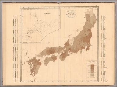


![Covers: 市區改正東亰實測全圖 / [Complete Survey Map of Tokyo with Revised Wards].](https://www.davidrumsey.com/rumsey/Size1/RUMSEY~8~1/195/15002001.jpg)
![市區改正東亰實測全圖 / [Complete Survey Map of Tokyo with Revised Wards].](https://www.davidrumsey.com/rumsey/Size2/RUMSEY~8~1/195/15002002.jpg)