|
Author
Beers, J.B.
Full Title
(Covers to) Map Of The State Of Connecticut. J.B. Beers & Co. 36 Vesey St. N.Y. 1886. Copyrighted 1885 by J.B. Beers & Co.
List No
0067.001
Author
Beers, J.B.
Full Title
Map Of The State Of Connecticut. J.B. Beers & Co. 36 Vesey St. N.Y. 1886. Copyrighted 1885 by J.B. Beers & Co.
List No
0067.002
Author
[United States. Naval Oceanographic Office, United States. Department of the Navy. Bureau of Navigation]
Full Title
(Covers to) Pilot chart : Dec. 1883. 1884-86.
List No
14381.001
Note
Covers to Pilot chart : Dec. 1883. 1884-86. Bound in dark brown board with gilt spine title and seal on front cover: Bibliothek Marinens.
Author
[United States. Naval Oceanographic Office, United States. Department of the Navy. Bureau of Navigation, Bartlett, J. R.]
Full Title
Pilot chart of the North Atlantic Ocean. December 1883. Prepared by order of the Bureau of Navigation, Commander J. R. Bartlett. U.S.N. Hydrographer. U.S. Hydrographic Office, Bureau of Navigation, Navy Department, Washington, D.C.
List No
14381.003
Note
Nautical chart of the North Atlantic Ocean representing December, 1883. Shows cities, coastlines, islands, sailing routes, ocean currents, storm tracks, wind force and directions, as well as the limits of ice coverage. Features shipwreck locations with dates of incidents. Includes latitudinal and longitudinal lines, a legend and compass rose with north oriented toward top of sheet. Descriptive text throughout. Black and white engraving, with red and blue infographics. Chart is 53 x 68 cm, on double sheet 60 x 84 cm.
Author
[United States. Naval Oceanographic Office, United States. Department of the Navy. Bureau of Navigation, Bartlett, J. R.]
Full Title
Pilot chart of the North Atlantic Ocean. January 1884. Prepared by order of the Bureau of Navigation, Commander J. R. Bartlett. U.S.N. Hydrographer. U.S. Hydrographic Office, Bureau of Navigation, Navy Department, Washington, D.C.
List No
14381.004
Note
Nautical chart of the North Atlantic Ocean representing January, 1884. Shows cities, coastlines, islands, sailing routes, ocean currents, storm tracks, wind force and directions, as well as the limits of ice coverage. Features shipwreck locations with dates of incidents. Includes latitudinal and longitudinal lines, a legend and compass rose with north oriented toward top of sheet. Descriptive text throughout. Black and white engraving, with red and blue infographics. Chart is 53 x 68 cm, on double sheet 60 x 84 cm.
Author
[United States. Naval Oceanographic Office, United States. Department of the Navy. Bureau of Navigation, Bartlett, J. R.]
Full Title
Pilot chart of the North Atlantic Ocean. February 1884. Prepared by order of the Bureau of Navigation, Commander J. R. Bartlett. U.S.N. Hydrographer. U.S. Hydrographic Office, Bureau of Navigation, Navy Department, Washington, D.C.
List No
14381.005
Note
Nautical chart of the North Atlantic Ocean representing February, 1884. Shows cities, coastlines, islands, sailing routes, ocean currents, storm tracks, wind force and directions, as well as icebergs, ice fields and the limits of ice coverage. Features shipwreck locations with dates of incidents. Includes latitudinal and longitudinal lines, a legend and compass rose with north oriented toward top of sheet. Descriptive text throughout. Black and white engraving, with red and blue infographics. Chart is 53 x 68 cm, on double sheet 60 x 84 cm.
Author
[United States. Naval Oceanographic Office, United States. Department of the Navy. Bureau of Navigation, Bartlett, J. R.]
Full Title
Pilot chart of the North Atlantic Ocean. March 1884. Prepared by order of the Bureau of Navigation, Commander J. R. Bartlett. U.S.N. Hydrographer. U.S. Hydrographic Office, Bureau of Navigation, Navy Department, Washington, D.C.
List No
14381.006
Note
Nautical chart of the North Atlantic Ocean representing March, 1884. Shows cities, coastlines, islands, sailing routes, ocean currents, storm tracks, wind force and directions, as well as icebergs, ice fields and the limits of ice coverage. Features shipwreck locations with dates of incidents. Includes latitudinal and longitudinal lines, a legend and compass rose with north oriented toward top of sheet. Descriptive text throughout. Black and white engraving, with red and blue infographics. Chart is 53 x 68 cm, on double sheet 60 x 84 cm.
Author
[United States. Naval Oceanographic Office, United States. Department of the Navy. Bureau of Navigation, Bartlett, J. R.]
Full Title
Pilot chart of the North Atlantic Ocean. April 1884. Prepared by order of the Bureau of Navigation, Commander J. R. Bartlett. U.S.N. Hydrographer. U.S. Hydrographic Office, Bureau of Navigation, Navy Department, Washington, D.C.
List No
14381.007
Note
Nautical chart of the North Atlantic Ocean representing April, 1884. Shows cities, coastlines, islands, sailing routes, ocean currents, storm tracks, wind force and directions, as well as icebergs, ice fields and the limits of ice coverage. Features shipwreck locations with dates of incidents. Includes latitudinal and longitudinal lines, a legend and compass rose with north oriented toward top of sheet. Descriptive text throughout. Black and white engraving, with red and blue infographics. Chart is 53 x 68 cm, on double sheet 60 x 84 cm.
Author
[United States. Naval Oceanographic Office, United States. Department of the Navy. Bureau of Navigation, Bartlett, J. R.]
Full Title
Pilot chart of the North Atlantic Ocean. May 1884. Prepared by order of the Bureau of Navigation, Commander J. R. Bartlett. U.S.N. Hydrographer. U.S. Hydrographic Office, Bureau of Navigation, Navy Department, Washington, D.C.
List No
14381.008
Note
Nautical chart of the North Atlantic Ocean representing May, 1884. Shows cities, coastlines, islands, sailing routes, ocean currents, storm tracks, wind force and directions, as well as icebergs, ice fields and the limits of ice coverage. Features shipwreck locations with dates of incidents. Includes latitudinal and longitudinal lines, a legend and compass rose with north oriented toward top of sheet. Descriptive text throughout. Black and white engraving, with red and blue infographics. Chart is 53 x 68 cm, on double sheet 60 x 84 cm.
Author
[United States. Naval Oceanographic Office, United States. Department of the Navy. Bureau of Navigation, Bartlett, J. R.]
Full Title
Pilot chart of the North Atlantic Ocean. June 1884. Prepared by order of the Bureau of Navigation, Commander J. R. Bartlett. U.S.N. Hydrographer. U.S. Hydrographic Office, Bureau of Navigation, Navy Department, Washington, D.C.
List No
14381.009
Note
Nautical chart of the North Atlantic Ocean representing June, 1884. Shows cities, coastlines, islands, sailing routes, ocean currents, storm tracks, wind force and directions, as well as icebergs, ice fields and the limits of ice coverage. Features shipwreck locations with dates of incidents. Includes latitudinal and longitudinal lines, a legend and compass rose with north oriented toward top of sheet. Descriptive text throughout. Black and white engraving, with red and blue infographics. Chart is 53 x 68 cm, on double sheet 60 x 84 cm.
Author
[United States. Naval Oceanographic Office, United States. Department of the Navy. Bureau of Navigation, Bartlett, J. R.]
Full Title
Pilot chart of the North Atlantic Ocean. July 1884. Prepared by order of the Bureau of Navigation, Commander J. R. Bartlett. U.S.N. Hydrographer. U.S. Hydrographic Office, Bureau of Navigation, Navy Department, Washington, D.C.
List No
14381.010
Note
Nautical chart of the North Atlantic Ocean representing July, 1884. Shows cities, coastlines, islands, sailing routes, ocean currents, storm tracks, wind force and directions, as well as icebergs, ice fields and the limits of ice coverage. Features shipwreck locations with dates of incidents. Includes latitudinal and longitudinal lines, a legend and compass rose with north oriented toward top of sheet. Descriptive text throughout. Black and white engraving, with red and blue infographics. Chart is 53 x 68 cm, on double sheet 60 x 84 cm.
Author
[United States. Naval Oceanographic Office, United States. Department of the Navy. Bureau of Navigation, Bartlett, J. R.]
Full Title
Pilot chart of the North Atlantic Ocean. August 1884. Prepared by order of the Bureau of Navigation, Commander J. R. Bartlett. U.S.N. Hydrographer. U.S. Hydrographic Office, Bureau of Navigation, Navy Department, Washington, D.C.
List No
14381.011
Note
Nautical chart of the North Atlantic Ocean representing August, 1884. Shows cities, coastlines, islands, sailing routes, ocean currents, storm tracks, wind force and directions, as well as icebergs, ice fields and the limits of ice coverage. Features shipwreck locations with dates of incidents. Includes latitudinal and longitudinal lines, a legend and compass rose with north oriented toward top of sheet. Descriptive text throughout. Black and white engraving, with red and blue infographics. Chart is 53 x 68 cm, on double sheet 60 x 84 cm.
Author
[Survey of India, Walker, J. & C.]
Full Title
Sheet 66 S.W. Indian Atlas. Parts of Bijnor, Kumaun, British Garhwal and Tarai (N.Wn. Provinces). Quarter Sheet.
List No
15217.000
Note
Printed from an Electrotype.
Author
[Survey of India, Walker, J. & C.]
Full Title
Sheet 66 N.W. Indian Atlas. Parts of District Garhwal and Native State Tehri-Garhwal, (N.W. Provinces). Quarter Sheet.
List No
15218.000
Note
Printed from an Electrotype.
Author
[France. Ministère des travaux publics. Administration des routes, France. Direction des cartes, plans et archives et de la statistique graphique, École nationale des ponts et chaussées (France)]
Full Title
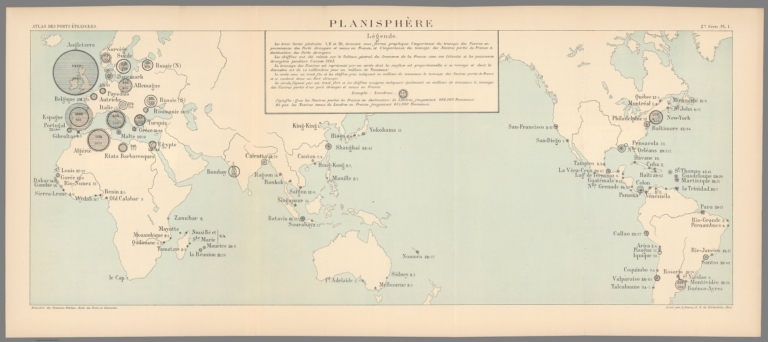
Planisphère. 2e Série. Pl. I. Ministère des Travaux Publics. Ecole des Ponts et Chaussées. Gravé par A. Simon, 13, R. du Val-de-Grâce. Paris.
List No
14306.036
Note
Map showing the ports of the world, in 1886 comparing the magnitude of imports to France from around the globe. Features seas, lakes, drainage, coastlines and islands. Includes a legend and data visualization. Lithograph in black, white and blue. Map is 28 x 70 cm, on fold-out sheet 33 x 75 cm. Bookplate title pasted to verso: Pl. I. Planisphère. Appears in Deuxième livraison.
Author
[France. Ministère des travaux publics. Administration des routes, France. Direction des cartes, plans et archives et de la statistique graphique, École nationale des ponts et chaussées (France)]
Full Title
Europe. 2e Série. Pl. II. Ministère des Travaux Publics. Ecole des Ponts et Chaussées. Gravé par A. Simon, 13, R. du Val-de-Grâce. Paris.
List No
14306.037
Note
Map showing the ports of Europe, in 1886, comparing the magnitude of imports to France from around the continent. Features seas, lakes, drainage, coastlines and islands. Includes data visualization. Lithograph in black, white and blue. Map is 32 x 46 cm, on sheet 33 x 50 cm. Bookplate title pasted to verso: Pl. II. Europe. Appears in Deuxième livraison.
Author
[France. Ministère des travaux publics. Administration des routes, France. Direction des cartes, plans et archives et de la statistique graphique, École nationale des ponts et chaussées (France)]
Full Title
Iles Britanniques. 2e Série. Pl. III. Ministère des Travaux Publics. Ecole des Ponts et Chaussées. Lith. A. Simon, 13, R. du Val-de-Grâce. Paris.
List No
14306.038
Note
Map showing the ports of the British Isles, in 1886, comparing the magnitude of imports to France from around the Isles. Features lakes, drainage, coastlines and islands. Includes data visualization. Lithograph in black, white and blue. Map is 27 x 22 cm, on sheet 33 x 25 cm. Appears in Deuxième livraison.
Author
[France. Ministère des travaux publics. Administration des routes, France. Direction des cartes, plans et archives et de la statistique graphique, École nationale des ponts et chaussées (France)]
Full Title
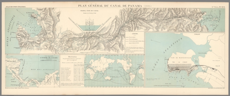
Plan général du Canal de Panama. (1886) -- Carte de'ensemble l'Isthme de Panama indiquant l'orientation du canal -- Abréviatoin des principales distances à parcourir par les navigateurs -- [Ile de Manzanillo]. 5e Série. Pl. XVII. Ministère des Travaux Publics. Ecole des Ponts et Chaussées. Lith. A. Simon, 13, R. du Val-de-Grâce. Paris.
List No
14306.134
Note
Four maps showing the Panama Canal, in 1886. Maps feature topography, railways, streets, bridges, drainage and docks and soundings, with depths given in meters. Relief shown with hachures. Two include a bar scale and compass rose, with north oriented toward top-left of sheet. Descriptive text throughout. Lithograph in black, white and blue. With a profile depicting a ship in the canal: Profil type du canal. Together, maps are 28 x 78 cm, on fold-out sheet 33 x 80 cm. Bookplate title pasted to verso: Pl. XVII. Plan général du Canal de Panama. Appears in Cinquième livraison.
Author
Kabai, Tatsunokuke
Full Title
(Covers to) 明治改正大日本明細全図. Meiji kaisei Dainippon meisai zenzu (Detailed and Total Map of Greater Japan, Revised in Meiji)
List No
10740.001
Author
Kabai, Tatsunokuke
Full Title
明治改正大日本明細全図. Meiji kaisei Dainippon meisai zenzu (Detailed and Total Map of Greater Japan, Revised in Meiji)
List No
10740.002
Author
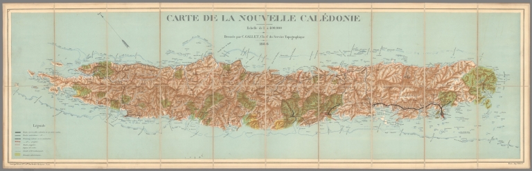
Gallet, Gustave
Full Title
Carte de la Nouvelle Caledonie.
List No
10725.002
Author
N. & C. R.R.
Full Title
Map of Lines Run From Holdrege East to Orange P.O. Range 13W. Mostly Run in 1886. C.D. Moore & Others. P-3015-24_2
List No
10302.000
Note
Blueprint.
Author
[Bertillon, Jacques, 1851-1922, Seine. Service de la statistique municipale]
Full Title
Paris 1886 : Population par groupes d'ages et par quartier. A. Baudry del. Grave chez L. Whurer. (to accompany) Atlas de statistique graphique de la ville de Paris. I-II. Annee 1888. Paris : G. Masson,1889.
List No
13101.007
Note
Map of Paris with statistical graphs on 2 sheets. Showing population by age groups and neighborhood in 1886. Includes text and legend.
Author
Stanford, Edward
Full Title
(Composite with Index Map and Legend) Stanford's Library Map of London and Its Suburbs. 24 Sheets. On the Scale of Six Inches to a Mile. London: Edward Stanford, 55, Charing Cross, S.W.
List No
10158.001
Note
Composite of labels on the backs of six map sheets.
Author
Stanford, Edward
Full Title
(Composite Map) (Stanford's Library Map of London and Its Suburbs.)
List No
10158.007
Note
Merging inner borders of the four maps.
Author
[Berghaus, Heinrich, Berghaus, Hermann]
Full Title
Eisverbreitung, einst und jetzt. Polar Ansicht der Erde in Lambert's flachenrechter Azimuthal-projection. Entw. v. Herm. Berghaus 1884, Ausg. 1886. Gotha: Justus Perthes. (On upper margin) I. Abt. Geologie No. V. Berghaus' physikal atlas No. 5. (to Accompany) Berghaus' Physikalischer Atlas. (Begrundet 1836 durch Heinrich Berghaus) ... Gotha: Justus Perthes. 1892. (7 insets).
List No
4391.016
Note
Color lithograph double hemisphere map with 7 insets. Depth shown by gradient tints, isoline and soundings. Relief shown by hachures. Insets: Der Rhein-Gletscher nach A. Favre -- Der Rhone Gletscher nach A. Falsan -- Seen-Gebiet in Nord-Amerika nach Chamberlin und Wright -- Die Europaischen Alpen -- Iseo-Gletscher nach Stroppani -- Der Loisach- und Inn-Gletscher n. Penck & Bayberger -- Die Sudlichen Alpen (Neu-Seeland) nach J. v. Haast. Includes legend and explanation.
Author
[Debray Sucesores (Firm), Diaz de Leon, Francisco]
Full Title
Plano general de indicacion de la Ciudad de Mexico : con la nueva division de los cuarteles y nomenclatura de los calles aprobado por el H. Ayuntamiento de 1885 y por el gobierno del distrito.Publicado por Debray Sucs. 1886. (inset) Chapultepec. (Cover title) Nueva subdivision de la ciudad Mexico en cuarteles y manzanas y correspondencia con la antigua.
List No
11439.007
Note
Folded color general plan of administrative divisions of Mexico City, 62 x 86, with 143 pages of explanatory text and index. Bound in heavy paper covers with cover title "Nueva subdivision de la ciudad Mexico en cuarteles y manzanas y correspondencia con la antigua. Map is based on the official sources of the Mexican government, was a part of the long sequence of constantly updated maps of Mexico City lithographed and published by Debray firm. Shows new administrative division of the barracks, tourist attractions, mining, railroads, buildings, landmarks, both old and new street names are noted. Includes explanation and list of public buildings and establishments.
Author
[Colomb, John Charles Ready, Crane, Walter]
Full Title
Imperial Federation - Map of the world showing the extent of the British Empire in 1886. Statistical information furnished by Captain J.C.R. Colomb, M.P. formerly R.M.A. Mclure & Co. Queen Victoria Street, London. British territories coloured in red. (Published as) Supplement to ''The Graphic'', July 24th, 1886. (Inset) Map of the world showing the extent of British territories in 1786.
List No
8238.000
Note
Pictorial map on Mercator projection centered on the Greenwich Prime Meridian, placing Great Britain just above the map's central focal point. Published as a color supplement to The "Graphic." The British Isles, and British colonies spreading out to the east and the west, were highlighted with red, while other geographical areas were left blank with only a minimum number of place names. An inset box was placed near each of the major colonies, listing statistics about geographical area, population, and trade. The words "Freedom, Fraternity, Federation," suggesting a peaceful coexistence within the British Empire, were prominently placed along the map's top margin, but the remainder of the map's illustrations imply "colonialism." At the bottom center Britannia is seated on top of the world ruling over her subjects, represented by a variety of animals and costumed figures. India, identified by an elephant and a tiger, appears in the lower left corner, while Australia, including a kangaroo and a sheep, is shown in the lower right. The illustrations were done by Walter Crane, a prominent illustrator and artist with strong socialist sympathies, perhaps explaining the contradictory themes in the map of imperialism and "human labour" holding up the world in the form of Atlas. Crane's contributions to the map remained unnoticed until the research of Pippa Biltcliffe was published in 2005.
Author
Weekly Pantagraph
Full Title
The Weekly Pantagraph's Premium Map Of McLean County, Ill. 1886. Copyrighted & Published By J.S. Hambaugh, Chicago. Geo. P. Ela, Civil And Drainage Engineer, Bloomington, Ill.
List No
3717.000
Note
Surrounded by advertisements for 16 Bloomington, Illinois businesses, including a beautiful illustration of "The Perfect Carbon," a parlor stove sold by the Bloomington Stove Company. Printed in full color by township.
Author
American Publishing Company
Full Title
Rambles Through Our Country. An Instructive Geographical Game For The Young. Copyright Secured 1881. American Publishing Company. Hartford, Conn. 1886.
List No
3886.000
Note
This is meant to accompany a board game with a map of the United States (see our #5086). However, it functions as a geography of the U.S. by itself. In full color.
Author
Canada Government Railways
Full Title
(Covers to) Map Shewing the Railways of Canada to Accompany Annual Report on Railway Statistics. 1886. Collingwood Schreiber, Chief Engineer and General Manager of Government Railways. Office Of The Chief Engineer And General Manager Of Government Railways. Compiled by E.V. Johnson, M.C.S.C.E., In charge of Draughting Offices. Drawn by A.M. Edmonds. The Burland Lithographic Co. Montreal. (seal) Department Of Railways And Canals Canada. (in red) Railways Of Canada. In Operation And Under Construction. 31st December, 1886 ...
List No
0121A
Note
Accompanies the Annual Report on Railway Statistics. With full printed color, the railways shown in red. The map is in two sheets, each dissected into 54 sections. The map sheets are folding with marbled end sheets and a brown cloth slip case 21x14 with a label reading "Canadian Dominion. London: Edward Stanford, Wholesale & Retail Mapseller, &c. 55, Charing Cross. Schreiber ..."
Author
Canada Government Railways
Full Title
Map Shewing the Railways of Canada to Accompany Annual Report on Railway Statistics. 1886. Collingwood Schreiber, Chief Engineer and General Manager of Government Railways. Office Of The Chief Engineer And General Manager Of Government Railways. Compiled by E.V. Johnson, M.C.S.C.E., In charge of Draughting Offices. Drawn by A.M. Edmonds. The Burland Lithographic Co. Montreal. (seal) Department Of Railways And Canals Canada. (in red) Railways Of Canada. In Operation And Under Construction. 31st December, 1886 ...
List No
0121.001
Note
Accompanies the Annual Report on Railway Statistics. With full printed color, the railways shown in red. The map is in two sheets, each dissected into 54 sections. The map sheets are folding with marbled end sheets and a brown cloth slip case 21x14 with a label reading "Canadian Dominion. London: Edward Stanford, Wholesale & Retail Mapseller, &c. 55, Charing Cross. Schreiber ..."
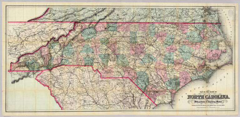
Author
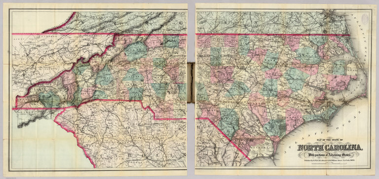
Colton, G.W. & C.B.
Full Title
(Covers to) Map Of The State Of North Carolina, With Portions Of Adjoining States. Published by G.W. & C.B. Colton & Co. 182 William Street, New York, 1886.
List No
0165.001
Note
2 sheets mounted separately. Stamp on map: "Supplied by Rand McNally & Co...Chicago." Full color by county, map is folded into dark brown cloth covers 18.5x12 with "Colton's Map Of The State Of North Carolina. G.W. & C.B. Colton & Co" stamped in gold.
Author
Colton, G.W. & C.B.
Full Title
Map Of The State Of North Carolina, With Portions Of Adjoining States. Published by G.W. & C.B. Colton & Co. 182 William Street, New York, 1886.
List No
0165.002
Note
2 sheets mounted separately. Stamp on map: "Supplied by Rand McNally & Co...Chicago." Full color by county, map is folded into dark brown cloth covers 18.5x12 with "Colton's Map Of The State Of North Carolina. G.W. & C.B. Colton & Co" stamped in gold.
Author
Colton, G.W. & C.B.
Full Title
(Composite of) Map Of The State Of North Carolina, With Portions Of Adjoining States. Published by G.W. & C.B. Colton & Co. 182 William Street, New York, 1886.
List No
0165.003
Note
Composite of 2 sheets mounted separately. Stamp on map: "Supplied by Rand McNally & Co...Chicago." Full color by county, map is folded into dark brown cloth covers 18.5x12 with "Colton's Map Of The State Of North Carolina. G.W. & C.B. Colton & Co" stamped in gold.
Author
Mitchell, Samuel Augustus Jr.
Full Title
(Covers to) Mitchell's New General Atlas, Containing Maps Of The Various Countries Of The World, Plans Of Cities, Etc., Embraced In Ninety-Three Quarto Maps, Forming A Series Of One Hundred and Forty-seven Maps and Plans, Together With Valuable Statistical Tables. Also, A List Of Post-Offices Of The United States And Territories, And Also Census Of 1880 For States, Territories And Counties, Also Of Cities Of Over 10,000 Inhabitants. Philadelphia: Published By Wm. M. Bradley & Bro., No. 1026 Arch Street. 1886. Entered ... 188_, by S. Augustus Mitchell ... Washington.
List No
0592
Note
Bound in black half leather, dark brown embossed cloth covered boards stamped with "Mitchell's Atlas Of The World" in gilt.
Author
Mitchell, Samuel Augustus Jr.
Full Title
(Title Page to) Mitchell's New General Atlas, Containing Maps Of The Various Countries Of The World, Plans Of Cities, Etc., Embraced In Ninety-Three Quarto Maps, Forming A Series Of One Hundred and Forty-seven Maps and Plans, Together With Valuable Statistical Tables. Also, A List Of Post-Offices Of The United States And Territories, And Also Census Of 1880 For States, Territories And Counties, Also Of Cities Of Over 10,000 Inhabitants. Philadelphia: Published By Wm. M. Bradley & Bro., No. 1026 Arch Street. 1886. Entered ... 188_, by S. Augustus Mitchell ... Washington.
List No
0592B
Author
Mitchell, Samuel Augustus Jr.
Full Title
(Contents to) Mitchell's New General Atlas, Containing Maps Of The Various Countries Of The World, Plans Of Cities, Etc., Embraced In Ninety-Three Quarto Maps, Forming A Series Of One Hundred and Forty-seven Maps and Plans, Together With Valuable Statistical Tables. Also, A List Of Post-Offices Of The United States And Territories, And Also Census Of 1880 For States, Territories And Counties, Also Of Cities Of Over 10,000 Inhabitants. Philadelphia: Published By Wm. M. Bradley & Bro., No. 1026 Arch Street. 1886. Entered ... 188_, by S. Augustus Mitchell ... Washington.
List No
0592C
Note
"Alphabetical list of the states and countries arranged for Mitchell's atlas of the World."
Author
Mitchell, Samuel Augustus Jr.
Full Title
A time table indicating the difference in time between the principal cities of the World and also showing their air-line distance from Washington. Entered ... 1864 by S. Augustus Mitchell, Jr. ... Pennsylvania.
List No
0592.001
Note
Hand colored lithograph.
Author
Mitchell, Samuel Augustus Jr.
Full Title
Western Hemisphere. Copyright by S. Augustus Mitchell 1884.
List No
0592.002
Note
Hand colored. Relief shown by hachures. Shows routes of James Cook and the U.S. Exploring Expedition. Includes inset drawings of comparative river lengths and heights in the Western Hemisphere. Includes inset maps of the Northern Hemisphere and Southern Hemisphere.
Author
Mitchell, Samuel Augustus Jr.
Full Title
Eastern Hemisphere. Copyright by S. Augustus Mitchell 1884.
List No
0592.003
Note
Hand colored. Relief shown by hachures. Shows routes of James Cook, Capt. Gore and the U.S. Exploring Expedition. Includes inset drawings of comparative river lengths and heights in the Eastern Hemisphere. Inset maps: Greatest mass of water -- Greatest mass of land.
Author
Mitchell, Samuel Augustus Jr.
Full Title
Map of the World on the Mercator projection, exhibiting the American Continent as its centre. Copyright by S. Augustus Mitchell 1884.
List No
0592.004
Note
Hand colored. Relief shown by hachures. Shows routes of ocean explorations, etc.
Author
Mitchell, Samuel Augustus Jr.
Full Title
Map of North America. Showing its political divisions, and recent discoveries in the Polar Regions. Copyright by S. Augustus Mitchell 1884.
List No
0592.005
Note
Hand colored. Relief shown by hachures. Shows settlements, rivers, etc. Prime meridians: Greenwich and Washington.
Author
Mitchell, Samuel Augustus Jr.
Full Title
County Map of Nova Scotia, New Brunswick, Cape Breton Id. and Pr. Edward's Id. (with) City and harbor of Halifax. Copyright by S. Augustus Mitchell 1884.
List No
0592.006
Note
Hand colored map with inset of City and Harbor of Halifax. Relief shown by hachures. Shows counties, settlements, rivers, etc. Prime meridians: Greenwich and Washington.
Author
Mitchell, Samuel Augustus Jr.
Full Title
Map of Ontario in counties. (with) Manitoba, Dominion of Canada. Copyright by S. Augustus Mitchell 1884.
List No
0592.007
Note
Hand colored. Relief shown by hachures. Shows settlements, railroads, rivers, etc. Prime meridians: Greenwich and Washington. Inset of Manitoba, Dominion of Canada.
Author
Mitchell, Samuel Augustus Jr.
Full Title
Map of Quebec in counties. (with) Environs of Montreal. Copyright by S. Augustus Mitchell 1884.
List No
0592.008
Note
Hand colored. Relief shown by hachures. Shows settlements, railroads, rivers, etc. Prime meridians: Greenwich and Washington.
Author
Mitchell, Samuel Augustus Jr.
Full Title
1776 Map of the Original Thirteen Colonies. Copyright by S. Augustus Mitchell 1884.
List No
0592.009
Note
Hand colored. Relief shown by hachures. Shows settlements, railroads, rivers, etc. Prime meridians: Greenwich and Washington. Has facsimile illustrations of the first money coined by the United States.
Author
Mitchell, Samuel Augustus Jr.
Full Title
Railroad map of the United States, showing the through lines of communication from the Atlantic to the Pacific, together with the various steamship lines along the seaboard. Copyright by Wm. M. Bradley & Bro. 1884.
List No
0592.010
Note
Red printed colored lines. Relief shown by hachures. Shows settlements, rivers, named railroads and steamship lines, etc. Prime meridians: Greenwich and Washington.
Author
Mitchell, Samuel Augustus Jr.
Full Title
Map of the United States, and territories. Together with Canada &c. (with) Island of Newfoundland. Copyright by S. Augustus Mitchell 1884.
List No
0592.011
Note
Hand colored map with inset. Relief shown by hachures. Shows settlements, rivers, etc. Prime meridians: Greenwich and Washington.
Author
Mitchell, Samuel Augustus Jr.
Full Title
County and township map of the state of Maine. Copyright 1882 by Bradley & Company.
List No
0592.012
Note
Hand colored. Relief shown by hachures. Shows settlements, railroads, rivers, etc. Prime meridians: Greenwich and Washington.
|