|
Author
[Renault, E., Buquet Family]
Full Title
EXPOSITION RÉGIONALE DE ROUEN 1884. Manufacture de E. Renault, à Rouen. 1884. (with) Plan de la Ville de Rouen.
List No
15430.000
Author
[United States. Naval Oceanographic Office, United States. Department of the Navy. Bureau of Navigation, Bartlett, J. R.]
Full Title
Pilot chart of the North Atlantic Ocean. January 1884. Prepared by order of the Bureau of Navigation, Commander J. R. Bartlett. U.S.N. Hydrographer. U.S. Hydrographic Office, Bureau of Navigation, Navy Department, Washington, D.C.
List No
14381.004
Note
Nautical chart of the North Atlantic Ocean representing January, 1884. Shows cities, coastlines, islands, sailing routes, ocean currents, storm tracks, wind force and directions, as well as the limits of ice coverage. Features shipwreck locations with dates of incidents. Includes latitudinal and longitudinal lines, a legend and compass rose with north oriented toward top of sheet. Descriptive text throughout. Black and white engraving, with red and blue infographics. Chart is 53 x 68 cm, on double sheet 60 x 84 cm.
Author
[United States. Naval Oceanographic Office, United States. Department of the Navy. Bureau of Navigation, Bartlett, J. R.]
Full Title
Pilot chart of the North Atlantic Ocean. February 1884. Prepared by order of the Bureau of Navigation, Commander J. R. Bartlett. U.S.N. Hydrographer. U.S. Hydrographic Office, Bureau of Navigation, Navy Department, Washington, D.C.
List No
14381.005
Note
Nautical chart of the North Atlantic Ocean representing February, 1884. Shows cities, coastlines, islands, sailing routes, ocean currents, storm tracks, wind force and directions, as well as icebergs, ice fields and the limits of ice coverage. Features shipwreck locations with dates of incidents. Includes latitudinal and longitudinal lines, a legend and compass rose with north oriented toward top of sheet. Descriptive text throughout. Black and white engraving, with red and blue infographics. Chart is 53 x 68 cm, on double sheet 60 x 84 cm.
Author
[United States. Naval Oceanographic Office, United States. Department of the Navy. Bureau of Navigation, Bartlett, J. R.]
Full Title
Pilot chart of the North Atlantic Ocean. March 1884. Prepared by order of the Bureau of Navigation, Commander J. R. Bartlett. U.S.N. Hydrographer. U.S. Hydrographic Office, Bureau of Navigation, Navy Department, Washington, D.C.
List No
14381.006
Note
Nautical chart of the North Atlantic Ocean representing March, 1884. Shows cities, coastlines, islands, sailing routes, ocean currents, storm tracks, wind force and directions, as well as icebergs, ice fields and the limits of ice coverage. Features shipwreck locations with dates of incidents. Includes latitudinal and longitudinal lines, a legend and compass rose with north oriented toward top of sheet. Descriptive text throughout. Black and white engraving, with red and blue infographics. Chart is 53 x 68 cm, on double sheet 60 x 84 cm.
Author
[United States. Naval Oceanographic Office, United States. Department of the Navy. Bureau of Navigation, Bartlett, J. R.]
Full Title
Pilot chart of the North Atlantic Ocean. April 1884. Prepared by order of the Bureau of Navigation, Commander J. R. Bartlett. U.S.N. Hydrographer. U.S. Hydrographic Office, Bureau of Navigation, Navy Department, Washington, D.C.
List No
14381.007
Note
Nautical chart of the North Atlantic Ocean representing April, 1884. Shows cities, coastlines, islands, sailing routes, ocean currents, storm tracks, wind force and directions, as well as icebergs, ice fields and the limits of ice coverage. Features shipwreck locations with dates of incidents. Includes latitudinal and longitudinal lines, a legend and compass rose with north oriented toward top of sheet. Descriptive text throughout. Black and white engraving, with red and blue infographics. Chart is 53 x 68 cm, on double sheet 60 x 84 cm.
Author
[United States. Naval Oceanographic Office, United States. Department of the Navy. Bureau of Navigation, Bartlett, J. R.]
Full Title
Pilot chart of the North Atlantic Ocean. May 1884. Prepared by order of the Bureau of Navigation, Commander J. R. Bartlett. U.S.N. Hydrographer. U.S. Hydrographic Office, Bureau of Navigation, Navy Department, Washington, D.C.
List No
14381.008
Note
Nautical chart of the North Atlantic Ocean representing May, 1884. Shows cities, coastlines, islands, sailing routes, ocean currents, storm tracks, wind force and directions, as well as icebergs, ice fields and the limits of ice coverage. Features shipwreck locations with dates of incidents. Includes latitudinal and longitudinal lines, a legend and compass rose with north oriented toward top of sheet. Descriptive text throughout. Black and white engraving, with red and blue infographics. Chart is 53 x 68 cm, on double sheet 60 x 84 cm.
Author
[United States. Naval Oceanographic Office, United States. Department of the Navy. Bureau of Navigation, Bartlett, J. R.]
Full Title
Pilot chart of the North Atlantic Ocean. June 1884. Prepared by order of the Bureau of Navigation, Commander J. R. Bartlett. U.S.N. Hydrographer. U.S. Hydrographic Office, Bureau of Navigation, Navy Department, Washington, D.C.
List No
14381.009
Note
Nautical chart of the North Atlantic Ocean representing June, 1884. Shows cities, coastlines, islands, sailing routes, ocean currents, storm tracks, wind force and directions, as well as icebergs, ice fields and the limits of ice coverage. Features shipwreck locations with dates of incidents. Includes latitudinal and longitudinal lines, a legend and compass rose with north oriented toward top of sheet. Descriptive text throughout. Black and white engraving, with red and blue infographics. Chart is 53 x 68 cm, on double sheet 60 x 84 cm.
Author
[United States. Naval Oceanographic Office, United States. Department of the Navy. Bureau of Navigation, Bartlett, J. R.]
Full Title
Pilot chart of the North Atlantic Ocean. July 1884. Prepared by order of the Bureau of Navigation, Commander J. R. Bartlett. U.S.N. Hydrographer. U.S. Hydrographic Office, Bureau of Navigation, Navy Department, Washington, D.C.
List No
14381.010
Note
Nautical chart of the North Atlantic Ocean representing July, 1884. Shows cities, coastlines, islands, sailing routes, ocean currents, storm tracks, wind force and directions, as well as icebergs, ice fields and the limits of ice coverage. Features shipwreck locations with dates of incidents. Includes latitudinal and longitudinal lines, a legend and compass rose with north oriented toward top of sheet. Descriptive text throughout. Black and white engraving, with red and blue infographics. Chart is 53 x 68 cm, on double sheet 60 x 84 cm.
Author
[United States. Naval Oceanographic Office, United States. Department of the Navy. Bureau of Navigation, Bartlett, J. R.]
Full Title
Pilot chart of the North Atlantic Ocean. August 1884. Prepared by order of the Bureau of Navigation, Commander J. R. Bartlett. U.S.N. Hydrographer. U.S. Hydrographic Office, Bureau of Navigation, Navy Department, Washington, D.C.
List No
14381.011
Note
Nautical chart of the North Atlantic Ocean representing August, 1884. Shows cities, coastlines, islands, sailing routes, ocean currents, storm tracks, wind force and directions, as well as icebergs, ice fields and the limits of ice coverage. Features shipwreck locations with dates of incidents. Includes latitudinal and longitudinal lines, a legend and compass rose with north oriented toward top of sheet. Descriptive text throughout. Black and white engraving, with red and blue infographics. Chart is 53 x 68 cm, on double sheet 60 x 84 cm.
Author
[Gill, J.K., Habersham, Robert A.]
Full Title
The Weekly Oregonian Map of Oregon & Washington. Copyrighted 1881. Published by the Oregonian Publ'ng Co. Showing all surveys made previous to March 1st 1884. Compiled by Robt. A. Habersham, Civil Engineer. Entered ... 1878 by J.K. Gill & Co. ... Washington. L.M. Snyder & Co. Map Publishers 79 Dearborn St. Chicago, Ill.
List No
5572.000
Author
Smith, E.R.
Full Title
Map Of The Eastern Townships of the Province Of Quebec, And Adjacent Territory. Published from Official and Authentic Returns, by E.R. Smith, Proprietor of "The News," Montreal And St. Johns, 1884. Copyrighted ... The Burland Litho Co., Engravers and Printers, Montreal.
List No
5077.000
Author
[France. Ministère des travaux publics. Administration des routes, France. Direction des cartes, plans et archives et de la statistique graphique]
Full Title
(Title Page to) Atlas des ports étrangers. Première livraison. Ministère des Travaux Publics. Direction des Cartes, Plans et Archives et de la Statistique Graphique. Paris. Imprimerie Nationale. MDCCCLXXXIV.
List No
14306.003
Note
Title page to first section of Atlas des ports étrangers, published in Paris, 1884. Title translates to: Atlas of foreign ports, first delivery. Includes statement of responsibility and imprint. With an embossed stamp in top-left corner: Ministère des Travaux Publics. Direction des Cartes et Plans. (Page number inferred.)
Author
[France. Ministère des travaux publics. Administration des routes, France. Direction des cartes, plans et archives et de la statistique graphique]
Full Title
(Text Page to) Notice sur l'Atlas des ports étrangers. 1re livraison (1).
List No
14306.004
Note
Introduction to first section of Atlas des ports étrangers, published in Paris, 1884. Title translates to: Notice on the Atlas of foreign ports, 1st delivery. First of two pages (V-VI). (Page number inferred.)
Author
[France. Ministère des travaux publics. Administration des routes, France. Direction des cartes, plans et archives et de la statistique graphique]
Full Title
(Text Page to) Notice sur l'Atlas des ports étrangers. 1re livraison (2).
List No
14306.005
Note
Introduction to first section of Atlas des ports étrangers, published in Paris, 1884. Title translates to: Notice on the Atlas of foreign ports, 1st delivery. Second of two pages (V-VI).
Author
[France. Ministère des travaux publics. Administration des routes, France. Direction des cartes, plans et archives et de la statistique graphique]
Full Title
Rio de Janeiro. 1ère Série. Pl. V. Direction des Cartes et Plans du Ministère des Travaux Publics. 1884. Aut. J. Marchadier et Cie. Rue de Lafayette, 150 Paris.
List No
14306.011
Note
Map showing the port of Rio de Janeiro, Brazil, in 1884. Features streets, bridges, drainage, islands, docks and soundings, with depths given in meters. Includes a bar scale and compass rose, with north oriented toward top of sheet. Descriptive text throughout. Lithograph in black, white and green. With two inset maps: Coupe en travers : du Quai projeté -- Coupe AB : Profil en travers du Brise-lames projeté. Together, maps are 29 x 23 cm, on sheet 33 x 25 cm. Appears in Première livraison.
Author
[France. Ministère des travaux publics. Administration des routes, France. Direction des cartes, plans et archives et de la statistique graphique]
Full Title
Magasins a Blé de Liverpool et Birkenhead : Liverpool. Waterloo Dock -- Birkenhead. Great Float. 2e. Série. Pl. XXI. Direction des Cartes et Plans du Ministère des Travaux Publics. 1884.
List No
14306.027
Note
Two views showing the docks of Liverpool and Birkenhead, England, in 1884, featuring streets, bridges, buildings and drainage. Lithograph in black and white. Together, views are 27 x 21 cm, on sheet 33 x 25 cm. Appears in Première livraison.
Author
[France. Ministère des travaux publics. Administration des routes, France. Direction des cartes, plans et archives et de la statistique graphique, Rose, Victor]
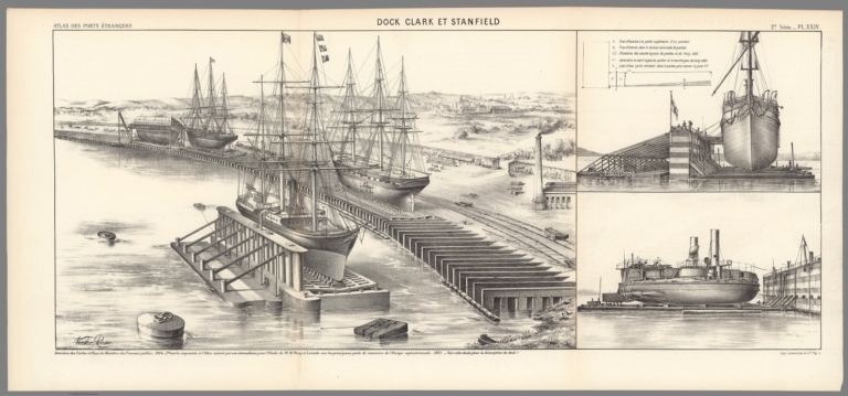
Full Title
Dock Clark et Stanfield. 2e. Série. Pl. XXIV. Victor Rose. Direction des Cartes et Plans du Ministère des Travaux Publics. 1884. (Planche empruntée à l'Atlas exécuté parson intermédiaire pour l'Etude de M. M. Plocq et Laroche sur les principaux ports de commerce de l'Europe septentrionale. 1882. Voir cette étude pòur la description du dock.) Imp. Lemercier et Cie. Paris.
List No
14306.030
Note
Three views showing the dock of Clark and Stanfield, in 1884, featuring streets, buildings and ships. Includes a legend. Lithograph in black and white. Together, views are 27 x 65 cm, on fold-out sheet 33 x 71 cm. Bookplate title pasted to verso: Pl. XXIV. 2e série. Dock Clark et Stanfield. Appears in Première livraison.
Author
[France. Ministère des travaux publics. Administration des routes, France. Direction des cartes, plans et archives et de la statistique graphique, École nationale des ponts et chaussées (France)]
Full Title
Buenos-Ayres. (1884). 4e Série. Pl. XIV. Ministère des Travaux Publics. Ecole des Ponts et Chaussées. Lith. A. Simon, 13, R. du Val-de-Grâce. Paris.
List No
14306.104
Note
Map showing the port of Buenos Aires, Argentina, in 1884. Features topography, streets, bridges, drainage, islands, docks and soundings, with depths given in meters. Relief shown with hachures. Includes a bar scale and compass rose, with north oriented toward top-right of sheet. Descriptive text throughout. Lithograph in black, white and blue. Map is 28 x 22 cm, on sheet 33 x 25 cm. Appears in Quatrième livraison.
Author
[France. Ministère des travaux publics. Administration des routes, France. Direction des cartes, plans et archives et de la statistique graphique, École nationale des ponts et chaussées (France)]
Full Title
Madras. (1884). Table Bay, Port des Galets. (1884) : Madras. (1884) -- Table Bay. (1888) (Colonie du Cap) -- Port des Galets. (Ile de la Reunion). 4e Série. Pl. XVII. Ministère des Travaux Publics. Ecole des Ponts et Chaussées. Lith. A. Simon, 13, R. du Val-de-Grâce. Paris.
List No
14306.107
Note
Three maps showing the ports of Madras [Chennai], India, Table Bay (South Africa) and Pointe des Galets, Réunion, in 1884. Maps feature topography, railways, streets, bridges, drainage, docks, islands and soundings, with depths given in meters. Relief shown with hachures. Each includes a bar scale and compass rose, with north oriented toward left, top-right and right of sheet, respectively. Descriptive text throughout. Lithograph in black, white and blue. Together, maps are 29 x 23 cm, on sheet 33 x 25 cm. Appears in Quatrième livraison.
Author
[France. Ministère des travaux publics. Administration des routes, France. Direction des cartes, plans et archives et de la statistique graphique, École nationale des ponts et chaussées (France)]
Full Title
Auckland, 1884 (Nelle Zélande). 6e Série. Pl. IX. Ministère des Travaux Publics. Ecole des Ponts et Chaussées. Lith. A. Simon, 13, R. du Val-de-Grâce. Paris.
List No
14306.152
Note
Map showing the port of Auckland, New Zealand, in 1884. Features topography, vegetation, railways, streets, bridges, canals, drainage, docks and soundings, with depths given in meters. Relief shown with hachures. Includes a bar scale and compass rose, with north oriented toward top of sheet. Descriptive text throughout. Lithograph in black, white and blue. With inset map: [Auckland and vicinity]. Together, maps are 38 x 43 cm, on fold-out sheet 24 x 50 cm. Bookplate title pasted to verso: Pl. IX. Aukland. Appears in Sixième livraison.
Author
Rand, McNally & Co.
Full Title
How the Public Domain Has Been Squandered : Map showing the 139,403,026 acres of the peoples land - equal to 871,268 Farms of 160 Acres Each Worth at $2 an acre, $278,806,052, Given By Republican Congresses to Railroad Corporations. This is more land than is contained in New York, New Jersey, Pennsylvania, Ohio, and Indiana.
List No
13665.000
Note
Political broadside map of the United States, 30x40 on sheet 59x42. setting forth the Democratic Party Platform of 1884 and illustrating "Land Grants to Railroads and Wagon Roadsap
Author
Pissis, Aime, 1812-1889
Full Title
(Covers to) Mapa de la Republica de Chile desde el rio Loa hasta el cabo de Hornos, por A. Pissis ... Lit. P. Cadot i Ca., Huerfanos, 25, (1884)
List No
0734A
Author
Pissis, Aime, 1812-1889
Full Title
Mapa de la Republica de Chile (1) desde el rio Loa hasta el cabo de Hornos, por A. Pissis ... Lit. P. Cadot i Ca., Huerfanos, 25, (1884)
List No
0734.001
Note
Lithographed map. Relief shown by hachures and spot heights. Includes atlas title and legend. Shows settlements, boundaries, mineral deposits, etc. Prime meridian: Santiago.
Author
Pissis, Aime, 1812-1889
Full Title
(Composite of) (Mapa de la Republica de Chile. 1-15. Desde el rio Loa hasta el cabo de Hornos, por A. Pissis) Lit. P. Cadot i Ca., Huerfanos, 25, (1884)
List No
0734.018
Note
15 lithographed maps. Relief shown by hachures and spot heights. Includes atlas title and legend. Shows settlements, boundaries, mineral deposits, etc. Prime meridian: Santiago. Includes "Erratas" on the readings of meridians west of Santiago.
Author
[Szechenyi, Bela, Kreitner Gustav, 1847-1893, Loczy, Ludwig von]
Full Title
(Title Page/Index to) Atlas zur Reiseroute in Ost-Asien 1877 bis 1880 des Grafen Bela Szechenyi. Original Aufnahme vom Gustav Kreitner ... geografischer Theil 17 Blatter ; Geologische Karte von Ludwig v. Loczy ... 15 Blatter ; Ausgefuhrt im K. K. Militar-Geografischen Institut in Wien.
List No
11196.002
Author
[Szechenyi, Bela, Kreitner Gustav, 1847-1893, Loczy, Ludwig von]
Full Title
A. I. Nach. Entwurfen vom K.K. Oberlietenant Gustav Kreitner. Reiseroute des Grafen Bela Szechenyi in Ostasien 1877 bis 1880. Bearbeitet im K. K. Militar Geograf. Institut in Wien.
List No
11196.003
Note
Geographical map, showing rivers, cities and towns. Relief shown by formlines and hachures. Prime meridian is Greenwich.
Author
[Szechenyi, Bela, Kreitner Gustav, 1847-1893, Loczy, Ludwig von]
Full Title
A.I. Geologische Aufnahme von Ludwig v. Loczy. Reiseroute des Grafen Bela Szechenyi in Ostasien 1877 bis 1880. Bearbeitet im K. K. Militar Geograf. Institut in Wien.
List No
11196.004
Note
Geological map, showing geological formations, rivers, cities and towns. Prime meridian is Greenwich.
Author
[Szechenyi, Bela, Kreitner Gustav, 1847-1893, Loczy, Ludwig von]
Full Title
(Composite map of) Geografischen Theile Atlas zur Reiseroute in Ost-Asien 1877 bis 1880 des Grafen Bela Szechenyi. Original Aufnahme vom Gustav Kreitner ... geografischer Theil 17 Blatter ; Geologische Karte von Ludwig v. Loczy ... 15 Blatter ; Ausgefuhrt im K. K. Militar-Geografischen Institut in Wien.
List No
11196.033
Note
Composite of all geographical sheets.
Author
[Szechenyi, Bela, Kreitner Gustav, 1847-1893, Loczy, Ludwig von]
Full Title
(Composite map of) Geologischen Theile Atlas zur Reiseroute in Ost-Asien 1877 bis 1880 des Grafen Bela Szechenyi. Original Aufnahme vom Gustav Kreitner ... geografischer Theil 17 Blatter ; Geologische Karte von Ludwig v. Loczy ... 15 Blatter ; Ausgefuhrt im K. K. Militar-Geografischen Institut in Wien.
List No
11196.034
Note
Composite of all geological sheets.
Author
[Arrowsmith, John, 1790-1873, Stanford, Edward, 1827-1904]
Full Title
(Covers /Title to) Stanford's London Atlas Of Universal Geography. Folio edition.
List No
11741.001
Note
Stanford's London Atlas Of Universal Geography, exhibiting the physical and political divisions of the various countries of the world. Partial folio edition published by Edward Stanford Ltd. Atlas dated 1884 by the maps. The Stanford map making company had been active in London since 1854. In 1874 they acquired the London atlas of 1834 from John Arrowsmith, with 50 maps which had increased to over 65 maps within 30 years. According to Francis Herbert, Stanford released a special limited edition in 1884 with 70 maps - our copy appears to be a partial set of those maps. Of the 70 plates, this portfolio contains 31 loose hand colored maps on 41 sheets in dark green cloth half bound leather portfolio with title stamped in gilt on the front cover. Title from the cover. Maps dated 1841-1884. Consists of sheets: 6-28, 30-32, 35-41, 43, 45,-46, 51-53, 57-58. Including maps of the continents, countries, kingdoms and empires. Showing political and administrative divisions, place names, and geographical features. Many maps printed on 2 or more sheets. Some sheets include 2 maps. On most maps noted: "Stanford’s Geographical Establishment, London." Most maps by J. Arrowsmith. Only two complete sets of the 1884 edition are known to exist, both in the archives of George Philip, who had taken over Stanford's in the mid-twentieth century, now held at the Royal Geographic Society, London. Eventually Stanford updated and added new plates. In 1887 Stanford published the London Atlas of universal geography folio edition with 90 plates. It contained important new maps, including the North Pole, Malta, Cyprus, the approaches to the Black Sea, parts of Canada and Australia.
Author
[Arrowsmith, John, 1790-1873, Stanford, Edward, 1827-1904]
Full Title
The Dardanelles and the Troad : Scale 1:190,080 ; The Bosphorus and Constantinople : Scle 1:95,040. London: Edward Stanford, 55 Charing Cross, S.W. Oct. 1st. 1877. Stanford's Geog. Estabt. (to accompany) Stanford's London Atlas Of Universal Geography. Folio edition.
List No
11741.035
Note
2 outline hand color maps on 1 folded sheet. Showing cities, towns, landmarks, roads, railroads, canals, mountains and rivers. Relief shown by hachures.
Author
[Arrowsmith, John, 1790-1873, Stanford, Edward, 1827-1904]
Full Title
The Sea of Marmara. London: Edward Stanford, 55 Charing Cross, S.W. April 7, 1879. Stanford's Geog. Estabt. (to accompany) Stanford's London Atlas Of Universal Geography. Folio edition.
List No
11741.036
Note
Outline hand color folded map. Showing administrative divisions (Vilayets or governments), cities, towns, landmarks, roads, railroads, canals, mountains and rivers. Relief shown by hachures and spot heights. Includes legend and explanation and table. Prime meridian is Greenwich.
Author
[Sohr, Karl, Berghaus, Heinrich, 1797-1884, Handtke, Friedrich, 1815-1879]
Full Title
(Title Page/Contents to) Sohr-Berghaus Hand-Atlas uber alle Theile der Erde. Neu bearbeitet von F. Handtke, 7. Auflage. Ausgabe in 100 Blattern. Verlag von Carl Flemming in Glogau. 1884.
List No
11653.002
Note
7th. edition, 1884 printing of new and improved Sohr-Berghaus Hand atlas of the world. New revision by F. Handtke. Glogau. Published by Carl Flemming, printed in 1878, 1879, 1880, 1881, 1883, 1884, 1886. The 7th. comprehensive edition includes 100 chrome lithographs mostly outline, partially colored or some full colored maps, some double-sheet, includes general maps, maps of European countries, regional maps of other European countries, maps for the other continents; and regional maps for the other continents. Maps are not dated; publication year only on title page; name of cartographer on 14 out of 100 maps, name of engraver on 1 map only. Maps showing seas, bays, ports, rivers, islands, mountains, cities, townships, villages, roads, railroads, telegraph cables, forts, mines, canals etc., including explanation, legend, tables and color coded key to colonies and European possessions. Prime meridians are Ferro, Paris and Greenwich. Relief shown by hachures. Bound into half leather brown covered boards with title “Sohr-Berghaus Hand atlas der neuen Erdbeschreibung in 100 blattern.” stamped on the front cover in gold. The name of Sohr is a pseudonym, probably of the editor of the atlas, F. (Friedrich) Handtke. The famous geographer Heinrich Berghaus had made a minor contribution to the atlas back in 1847. Carl Flemming, publisher of the atlas, used this to mention Berghaus' name prominently on the atlas title page. Berghaus protested against this abuse of his name, but the atlas has kept its name of Sohr-Berghaus ever since.
Author
[Sohr, Karl, Berghaus, Heinrich, 1797-1884, Handtke, Friedrich, 1815-1879, Klein, H.J.]
Full Title
Das Planeten-System II. Gez. v. Dr. H. J. Klein. Druck und Verlag von Carl Flemming. (to accompany) Sohr-Berghaus Hand-Atlas ... von F. Handtke, 7. Auflage. Ausgabe. 1884.
List No
11653.004
Note
Uncolored views of the moon. Surrounded by various planets, charts, text and tables.
Author
[Sohr, Karl, Berghaus, Heinrich, 1797-1884, Handtke, Friedrich, 1815-1879]
Full Title
Fluss- und Gebirgs-Karte von Mittel-Europa. Druck und Verlag von Carl Flemming. (to accompany) Sohr-Berghaus Hand-Atlas ... von F. Handtke, 7. Auflage. Ausgabe. 1884. (inset) Spitzbergen.
List No
11653.011
Note
Engraved lithograph color map of Rivers and mountains of Central Europe. Relief shown by hachures and gradient tints. Prime meridians are Ferro and Paris.
Author
Deperlas, F.
Full Title
Etats-Unis du Grand Continent (Europe, Asie, Afrique). Premiere Alliance des Peuples avec la Republique Francaise ... par le Prophete C.M.
List No
12458.000
Note
Date estimated.
Author
United States Coast Survey
Full Title
San Francisco entrance, California : 1884. Issued Aug. 1884, J.E. Hilgard, Superintendent, Verified: C.O. Boutelle, Assiatant in charge of office. Price 50 cents. Redd. Drng. by A. Lindenkohl, C. Junken, E. Molkow and E.J. Sommer. Engd. by J. Enthoffer, E. A. Maedel, J.J. Young, W. Thompson, H.M. Knight, A. Petersen and J.G. Thompson. Triangulation by R.D. Cutts, A.F. Rodgers ... ; topography by R.D. Cutts, A.F. Rogers, A.M. Harrison ... ; hydrography by J. Alden, R,M. Cuyler ...
List No
6726.000
Note
Nautical chart of San Francisco Bay entrance, Printed without color. Relief shown by contours and spot heights. Depths shown by soundings. Includes text, tide chart, and chart of lighthouses and signal stations. "No. 621a., Electrotype copy no. 1 by U.S.C.& G.S." Plate No. 1829.
Author
Nell, Louis
Full Title
(Covers to) Nell's Topographical & Township Map of the State of Colorado. Compiled from U.S. Government Surveys & other authentic Sources. Washington D.C. 1884. Chain & Hardy, Agents. 414 Larimer Str. Denver. Entered ... 1881, by Louis Nell ... Washington D.C. Am. Photo-Litho. Co. N.Y.
List No
0662A
Author
Nell, Louis
Full Title
Nell's Topographical & Township Map of the State of Colorado. Compiled from U.S. Government Surveys & other authentic Sources. Washington D.C. 1884. Chain & Hardy, Agents. 414 Larimer Str. Denver. Entered ... 1881, by Louis Nell ... Washington D.C. Am. Photo-Litho. Co. N.Y.
List No
0662.001
Note
Full color by county. Nell did many of the Wheeler survey maps. The Ellis copy of this map was issued in Washington by Stone & Co. Folded into textured dark green cloth covers 17x10.5 with "Nell's Topographical And Township Map Of The State Of Colorado." stamped in gilt.
Author
[Alaskan Boundary Tribunal, Mohun, Edward]
Full Title
(Facsimile) Map of the Province of British Columbia, Compiled and drawn by Edward Mohun, C.E. by Direction of the Honorable W. Smithe. Chief Commissioner of Lands and Works. Victoria, B.C. 1884. Dawson Brothers, Montreal. Photo. Lith. by A. Hoen & Co. Baltimore, MD. Engraved & Printed by Bartholomew Edinburgh.
List No
0009.032
Note
Tinted.
Author
[Alaskan Boundary Tribunal, Selwyn, Alfred R.C.]
Full Title
(Facsimile) Geological and Natural History Survey of Canada (portion). Alfred R.C. Selwyn L.L.D., F.R.S., Director. Map of the Dominion of Canada. Geologically Colored from Surveys made by the Geological Corps, 1842-1882. Photo. Lith. by A. Hoen & Co. Baltimore, MD.
List No
0009.033
Note
Relief shown by hachures.
Author
[Alaskan Boundary Tribunal, British Admiralty]
Full Title
(Facsimile) Part of British Admiralty Chart. No. 2431. Cordova Bay to Cross Sound. 1865 Corrections to 1884. Photo. Lith. by A. Hoen & Co. Baltimore, MD.
List No
0009.034
Note
Relief shown by hachures.
Author
Alaskan Boundary Tribunal
Full Title
(Facsimiles) (Eight Comparison Maps Southern Alaskan Coast 1884-1903 (portions)): Official British Columbia map, 1884; Official British Columbia map, 1895; Official British Columbia map, 1884; Map of Year Book of British Columbia, 1897; Dawson's map, 1887; Map presented to Joint High Commission in 1898 by British Commissioners; Official British Columbia map, 1893; Map 37, Case of Great Britain, Appendix, Vol. II, 1903. Alaskan Boundary Tribunal, 1903. 28. Andrew B. Graham. Photo-Litho. Washington.D.C.
List No
0009.071
Note
Maps from various sources on the same scale.
Author
[Gray, Frank A., Gray, O.W.]
Full Title
(Covers to) The National Atlas. Containing Elaborate Topographical Maps Of The United States And The Dominion of Canada, With Plans Of Cities And General Maps Of The World. Also, Descriptions and Tables, Historical and Statistical ... Accompanied By Special, Railway, And Scientific Maps And Articles. Special Edition. Stedman & Brown, Publishers, No. 56 North Fourth Street, Philadelphia. Philadelphia: O.W. Gray & Son, Geographical Establishment, No. 56 North Fourth Street. 1884. (on verso) Copyright 1876, by O.W. Gray & Son. Entered ... 1882, by O.W. Gray & Son ... Washington.
List No
0312.001
Note
Atlas is bound in half leather brown cloth covered boards with "The National Atlas" stamped on the front cover and spine in gilt.
Author
[Gray, Frank A., Gray, O.W.]
Full Title
(Text Page) (Owner Plate).
List No
0312.002
Author
[Gray, Frank A., Gray, O.W.]
Full Title
(Title Page) The National Atlas. Containing Elaborate Topographical Maps Of The United States And The Dominion of Canada, With Plans Of Cities And General Maps Of The World. Also, Descriptions and Tables, Historical and Statistical ... Accompanied By Special, Railway, And Scientific Maps And Articles. Special Edition. Stedman & Brown, Publishers, No. 56 North Fourth Street, Philadelphia. Philadelphia: O.W. Gray & Son, Geographical Establishment, No. 56 North Fourth Street. 1884. (on verso) Copyright 1876, by O.W. Gray & Son. Entered ... 1882, by O.W. Gray & Son ... Washington.
List No
0312.003
Author
[Gray, Frank A., Gray, O.W.]
Full Title
(Title Page Verso) Copyright 1876 ... Entered ... 1884, by O.W. Gray & Co. .... (Index Page) Table of Contents.
List No
0312.004
Author
[Gray, Frank A., Gray, O.W.]
Full Title
Eastern Hemisphere. Western Hemisphere. Entered ... 1879 by O.W. Gray & Son.
List No
0312.005
Note
Includes illustrations of Heights of Mountains and Lengths of Rivers, and a Time Diagram.
Author
[Colton, J.H., Gray, O.W.]
Full Title
North America. Entered ... 1855 by J.H. Colton & Co. ....
List No
0312.006
Author
[Gray, Frank A., Gray, O.W.]
Full Title
Gray's New Map of the United States. By Frank A. Gray. (insets) Alaska. Sketch Showing the Westward Movement of the Centre of Population. Copyright 1879 by O.W. Gray & Son.
List No
0312.007
Author
Gray, O.W.
Full Title
(Statistical Diagram) Chart Exhibiting the Relative Rank of the States for Nine Decades.
List No
0312.008
Author
[Colton, J.H., Gray, O.W.]
Full Title
Maine. Entered ... 1855 by J.H. Colton & Co. ....
List No
0312.009
Author
[Colton, J.H., Gray, O.W.]
Full Title
New Hampshire. Entered ... 1855 by J.H. Colton & Co. ....
List No
0312.010
Author
[Colton, J.H., Gray, O.W.]
Full Title
Vermont. Entered ... 1855 by J.H. Colton & Co. ....
List No
0312.011
Author
[Gray, Frank A., Gray, O.W.]
Full Title
Gray's New Map of Massachusetts, Rhode Island, and Connecticut by Frank A. Gray. Copyright 1876 by O.W. Gray & Son. (inset) Boston.
List No
0312.012
Author
[Walling, H.F., Gray, O.W.]
Full Title
Boston and Adjacent Cities. By H.F. Walling.
List No
0312.013
Author
[Colton, G. Woolworth, Gray, O.W.]
Full Title
New York City, Brooklyn, Jersey City, Hoboken, Etc. Copyright, 1865, by G. Woolworth Colton.
List No
0312.014
Author
[Gray, Frank A., Gray, O.W.]
Full Title
New York by Frank A. Gray. Entered ... 1876 by O.W. Gray & Son. (insets) Niagara River and Vicinity. Vicinity of New York. Map of the Hudson River from New York to Saratoga Springs.
List No
0312.015
Author
[Colton, G.W., Colton, C.B., Gray, O.W.]
Full Title
New Jersey. Entered ... 1868 by G.W. & C.B. Colton & Co. ....
List No
0312.016
Author
[Gray, Frank A., Gray, O.W.]
Full Title
Pennsylvania by Frank A. Gray. Copyright 1883 by O.W. Gray & Son.
List No
0312.017
Author
[Gray, Frank A., Gray, O.W.]
Full Title
Philadelphia. (inset) Outline Map of the County and City of Philadelphia and Vicinity. Copyright, 1883, by G.W. Gray & Son.
List No
0312.018
Author
[Gray, Frank A., Gray, O.W.]
Full Title
Gray's New Map of Baltimore by Frank A. Gray. Copyright 1876 by O.W. Gray & Son. (inset) Patapsco River and the Approaches.
List No
0312.019
Author
[Gray, Frank A., Gray, O.W.]
Full Title
Maryland, Delaware and the District of Columbia by Frank A. Gray. Copyright 1876 by O.W. Gray & Son. (inserts) Washington (D.C.). Wilington, Delaware. Annapolis. Annapolis Harbor and Environs.
List No
0312.020
Author
[Gray, Frank A., Gray, O.W.]
Full Title
Gray's New Map of Richmond, Henrico County, Virginia.
List No
0312.021
Author
[Gray, O.W., Robinson, Frederic H.]
Full Title
City of Wilmington, Delaware. Drawn by Frederic H. Robinson, City Engineer, 1884.
List No
0312.022
Author
[Gray, Frank A., Gray, O.W.]
Full Title
Virginia and West Virginia by Frank A. Gray. Copyright 1877 by O.W. Gray. (insets) Environs of Harpers Ferry. Hampton Roads and the Approach. Hypsometric Sketch of Virginia and West Virginia. Norfolk Harbor.
List No
0312.023
Author
[Gray, Frank A., Gray, O.W.]
Full Title
Gray's New Map of North Carolina and South Carolina by Frank A. Gray. Entered ... 1881 by O.W. Gray & Son. (insert) Charleston Harbor and its Approaches.
List No
0312.024
Author
Gray, O.W.
Full Title
Florida.
List No
0312.025
Author
[Gray, Frank A., Gray, O.W.]
Full Title
Gray's New Map of Georgia by Frank A. Gray. Copyright 1877 by O.W. Gray & Son. (insets) Entrance to Savannah River. Savannah.
List No
0312.026
Author
[Gray, Frank A., Gray, O.W.]
Full Title
Gray's New Map of Alabama by Frank A. Gray. (inset) Entrance to Mobile Bay.
List No
0312.027
Author
[Gray, Frank A., Gray, O.W.]
Full Title
Gray's New Map of Mississippi by Frank A. Gray.
List No
0312.028
Author
[Gray, Frank A., Gray, O.W.]
Full Title
Gray's New Map of Louisiana by Frank A. Gray. Copyright 1878 by O.W. Gray & Son. (insets) City of New Orleans. The Passes of the Mississippi River.
List No
0312.029
Author
[Gray, Frank A., Gray, O.W.]
Full Title
Gray's Map of Texas and the Indian Territory by Frank A. Gray. Copyright 1876 by O.W. Gray & Son. (insets) Hypsometric Sketch of Texas and the Indian Territory. Austin. Matagorda Bay. The City of Galveston. Entrance to Galveston Bay. The River Systems if Texas and the Indian Territory.
List No
0312.030
Author
[Gray, Frank A., Gray, O.W.]
Full Title
Arkansas by Frank A. Gray. Entered ... 1876 by O.W. Gray & Son.
List No
0312.031
Author
Gray, O.W.
Full Title
Indianapolis. Louisville.
List No
0312.032
Author
[Gray, Frank A., Gray, O.W.]
Full Title
Gray's New Map of Kentucky and Tennessee by Frank A. Gray. Copyright 1876 by O.W. Gray & Son. (insets) Outline Map of Kentucky and Tennessee illustrating the System of Railroads. Hyposometric Sketch of Kentucky Tennessee. Outline Map of Kentucky and Tennessee illustrating the Density of Population.
List No
0312.033
Author
[Gray, Frank A., Gray, O.W.]
Full Title
Gray's New Map of Cincinnati by Frank A. Gray. Copyright 1877 by O.W. Gray & Son. (inset) Outline Map of Cincinnati.
List No
0312.034
Author
[Gray, Frank A., Gray, O.W.]
Full Title
Gray's New Map of Ohio by Frank A. Gray. Copyright 1877 by O.W. Gray & Son. (insets) Physical Map of Ohio. Historical Map of Ohio. Vicinity of Cleveland. Vicinity of Toledo. City of Columbus. Vicinity of Cincinnati.
List No
0312.035
Author
[Gray, Frank A., Gray, O.W.]
Full Title
Gray's New Map of Indiana by Frank A. Gray. Copyright 1882 by O.W. Gray & Son.
List No
0312.036
Author
[Gray, Frank A., Gray, O.W.]
Full Title
Gray's New Map of Dakota with Part of Manitoba, Etc. by Frank A. Gray. Copyright 1883 by O.W. Gray & Son.
List No
0312.037
Author
[Gray, Frank A., Gray, O.W.]
Full Title
Lake Superior and the Northern Part of Michigan.
List No
0312.038
Author
[Colton, G.W., Colton, C.B., Gray, O.W.]
Full Title
Michigan. Copyright, 1874, by G.W. & C.B. Colton & Co.
List No
0312.039
Author
[Colton, G.W., Colton, C.B., Gray, O.W.]
Full Title
Minnesota. Entered ... 1867, by G.W. & C.B. Colton & Co.
List No
0312.040
Author
[Gray, Frank A., Gray, O.W.]
Full Title
Gray's New Map of Iowa by Frank A. Gray. Copyright - 1877 by O.W. Gray & Son.
List No
0312.041
Author
[Gray, Frank A., Gray, O.W.]
Full Title
Gray's New Map of Wisconsin by Frank A. Gray. Entered ... 1881 by O.W. Gray & Son.
List No
0312.042
Author
[Gray, Frank A., Gray, O.W.]
Full Title
Gray's New Map of Chicago by Frank A. Gray. Copyright 1881 by O.W. Gray & Son.
List No
0312.043
Author
[Gray, Frank A., Gray, O.W.]
Full Title
Illinois. Entered ... 1867 by G.W. & C.B. Colton & Co. (inset) Plan of Cook County & Vicinity of Chicago.
List No
0312.044
Author
[Colton, G.W., Colton, C.B., Gray, O.W.]
Full Title
Missouri. Entered ... 1869 by G.W. & C.B. Colton & Co.
List No
0312.045
Author
[Gray, Frank A., Gray, O.W.]
Full Title
Gray's New Map of Saint Louis by Frank A. Gray.
List No
0312.046
Author
[Gray, Frank A., Gray, O.W.]
Full Title
Gray's New Map of Kansas by Frank A. Gray. Entered ... 1881 by O.W. Gray & Son.
List No
0312.047
Author
[Gray, Frank A., Gray, O.W.]
Full Title
Nebraska. Copyright 1877 by O.W. Gray & Son.
List No
0312.048
Author
[Gray, Frank A., Gray, O.W.]
Full Title
Gray's Idaho, Montana and Wyoming.
List No
0312.049
Author
[Gray, Frank A., Gray, O.W.]
Full Title
Colorado.
List No
0312.050
Author
[Gray, Frank A., Gray, O.W.]
Full Title
Oregon and Washington.
List No
0312.051
Author
[Gray, Frank A., Gray, O.W.]
Full Title
California and Nevada. (insets) Map of the Yosemite Valley, Mariposa Co. Cal. Plan of Sacramento. The Vicinity of San Francisco
List No
0312.052
Author
Gray, O.W.
Full Title
San Francisco.
List No
0312.053
Author
[Gray, Frank A., Gray, O.W.]
Full Title
Gray's New Map of Utah by Frank A. Gray.
List No
0312.054
Author
[Gray, Frank A., Gray, O.W.]
Full Title
Arizona and New Mexico.
List No
0312.055
Author
Gray, O.W.
Full Title
Map of the Territory of Alaska (Russian America) Ceded by Russia to the United States.
List No
0312.056
Author
Gray, O.W.
Full Title
Provinces of Ontario and Quebec Dominion of Canada. Eastern Portion of the Province of Quebec.
List No
0312.057
Author
Gray, O.W.
Full Title
New Brunswick, Nova Scotia, Newfoundland, and Prince Edward Id.
List No
0312.058
Author
Gray, O.W.
Full Title
Mexico. (insets) Mexico to Vera Cruz. The Isthmus of Tehuantepec.
List No
0312.059
Author
Gray, O.W.
Full Title
West Indies and Central America. (inset) The Burmuda Islands.
List No
0312.060
Author
Gray, O.W.
Full Title
South America.
List No
0312.061
Author
Gray, O.W.
Full Title
Gray's New Map of Europe by Frank A. Gray. Copyright 1877 by O.W. Gray & Son. (inset) Outline Ethnographical Map of Europe.
List No
0312.062
Author
Gray, O.W.
Full Title
British Isles. (inset) Shetland and Orkney Islands.
List No
0312.063
Author
Gray, O.W.
Full Title
Germany, Austria, and Switzerland.
List No
0312.064
Author
[Gray, Frank A., Gray, O.W.]
Full Title
Gray's New Map of Spain and Portugal by Frank A. Gray. (insets) Environs of Madrid. Gibraltar. Environs of Lisbon.
List No
0312.065
Author
[Gray, Frank A., Gray, O.W.]
Full Title
Switzerland. Entered ... 1855 by J.. Colton & Co. ....
List No
0312.066
Author
[Gray, Frank A., Gray, O.W.]
Full Title
Gray's New Map of Italy by Frank A. Gray. (insets) Environs of Palermo. Environs of Naples. Environs of Rome. Environs of San Marino. Mount Etna.
List No
0312.067
Author
Gray, O.W.
Full Title
Gray's New Map of the Countries Surrounding the Black Sea Comprising Turkey in Europe and Turkey in Asia, Greece (Hellas), Southern Russia etc. by Frank A. Gray. (insets) Environs of Athens and Piraeus. The Bosphorus or Strait of Constantinope.
List No
0312.068
Note
Includes etymological explanation of various prefixes, terminations, and formative syllables of many names on the map.
Author
[Gray, Frank A., Gray, O.W.]
Full Title
Gray's New Map of Russia in Europe by Frank A. Gray.
List No
0312.069
Author
Gray, O.W.
Full Title
France.
List No
0312.070
Author
Gray, O.W.
Full Title
Palestine. (inset) Arabia Petraea.
List No
0312.071
Author
[Gray, Frank A., Gray, O.W.]
Full Title
Gray's New Map of Africa by Frank A. Gray. Entered ... 1880 by O.W. Gray & Son .... (insets) The Delta of the Nile. Island of St. Helena.
List No
0312.072
Author
[Gray, Frank A., Gray, O.W.]
Full Title
Gray's New Map of Australia by Frank A. Gray. Copyright 1878 by O.W. Gray & Son. (inset) Tasmania.
List No
0312.073
Author
Gray, O.W.
Full Title
Asia.
List No
0312.074
Author
[Colton, J.H., Gray, O.W.]
Full Title
Hindostan or British India. Entered ... 1855 by J.H. Colton & Co. ....
List No
0312.075
Author
Gray, O.W.
Full Title
(Statistical Table) Table Showing the Parcels of Territory Comprising Each Political Division (United States).
List No
0312.076
Author
[Gray, Frank A., Gray, O.W.]
Full Title
Gray's Historical Maps of the United States by Frank A. Gray.
List No
0312.077
Author
Hitchcock, Charles H.
Full Title
(Text Page) Geological Description (of the United States) by Charles H. Hitchcock, Ph.D., Professor of Geology in Dartmouth College, Hanover, N.H.
List No
0312.078
Author
[Gray, O.W., Hitchcock, Charles H.]
Full Title
Gray's Geological Map of the United States by Prof. Charles H. Hitchcock. Copyright 1882 by O.W. Gray & Son.
List No
0312.079
Author
Hitchcock, Charles H.
Full Title
(Text Page) Geological Description (of the United States) by Charles H. Hitchcock, Ph.D. (continued).
List No
0312.080
Author
Blodget, Lorin
Full Title
(Text Page) Climatological Description (of the United States) by Lorin Blodget.
List No
0312.081
Author
Blodget, Lorin
Full Title
Climatological Map of the United States Showing Average Temperature, Amount of Rain Fall &c. by Lorin Blodget.
List No
0312.082
Note
Date estimated.
Author
Blodget, Lorin
Full Title
(Text Page) Climatological Description (of the United States) (continued) by Lorin Blodget.
List No
0312.083
Author
[Gray, Frank A., Gray, O.W.]
Full Title
Gray's Botanical and Zoological Maps of the United States. Copyright 1877 by O.W.Gray & Son.
List No
0312.084
Author
Porter, Thomas C.
Full Title
(Text Page) Botanical Description (of the United States). By Thomas C. Porter, A.M., Professor of Botany in Lafayette College, Easton, Pa.
List No
0312.085
Author
Porter, Thomas C.
Full Title
(Text Page) Botanical Description (of the United States) (continued). By Thomas C. Porter, A.M., Professor of Botany in Lafayette College, Easton, Pa.
List No
0312.086
Author
Cope, Edward D.
Full Title
(Text Page) Zoological Description (of the United States). By Professor Edward D. Cope, A.M., Secretary of the Academy of Natural Sciences, Philadelphia.
List No
0312.087
Author
Cope, Edward D.
Full Title
(Text Page) Zoological Description (of the United States) (continued). By Professor Edward D. Cope, A.M., Secretary of the Academy of Natural Sciences, Philadelphia.
List No
0312.088
Author
Cope, Edward D.
Full Title
(Text Page) Zoological Description (of the United States) (continued). By Professor Edward D. Cope, A.M., Secretary of the Academy of Natural Sciences, Philadelphia.
List No
0312.089
Author
Cope, Edward D.
Full Title
(Text Page) Zoological Description (of the United States) (continued). By Professor Edward D. Cope, A.M., Secretary of the Academy of Natural Sciences, Philadelphia.
List No
0312.090
Author
[Gray, Frank A., Gray, O.W.]
Full Title
(Text Page) Professional Directory of Patrons. Wilmington, Del.
List No
0312.091
Author
[Gray, Frank A., Gray, O.W.]
Full Title
(Text Page) Professional Directory of Patrons. Wilmington, Del. (continued). The National Atlas. Professional Directory of Patrons. City of Philadelphia.
List No
0312.092
Author
[Gray, Frank A., Gray, O.W.]
Full Title
(Text Page) The National Atlas - Pennsylvania Directory - Continued.
List No
0312.093
Author
[Gray, Frank A., Gray, O.W.]
Full Title
(Text Page) The National Atlas - Pennsylvania Directory - Continued. City of Pittsburgh.
List No
0312.094
Author
[Gray, Frank A., Gray, O.W.]
Full Title
(Text Page) The National Atlas - Pennsylvania Directory - Continued.
List No
0312.095
Author
[Gray, Frank A., Gray, O.W.]
Full Title
(Text Page) The National Atlas - Pennsylvania Directory - Continued.
List No
0312.096
Author
[Gray, Frank A., Gray, O.W.]
Full Title
(Text Page) The National Atlas - Pennsylvania Directory - Continued.
List No
0312.097
Author
Mitchell, Samuel Augustus Jr.
Full Title
Western Hemisphere. Copyright by S. Augustus Mitchell 1884.
List No
0592.002
Note
Hand colored. Relief shown by hachures. Shows routes of James Cook and the U.S. Exploring Expedition. Includes inset drawings of comparative river lengths and heights in the Western Hemisphere. Includes inset maps of the Northern Hemisphere and Southern Hemisphere.
Author
Mitchell, Samuel Augustus Jr.
Full Title
Eastern Hemisphere. Copyright by S. Augustus Mitchell 1884.
List No
0592.003
Note
Hand colored. Relief shown by hachures. Shows routes of James Cook, Capt. Gore and the U.S. Exploring Expedition. Includes inset drawings of comparative river lengths and heights in the Eastern Hemisphere. Inset maps: Greatest mass of water -- Greatest mass of land.
Author
Mitchell, Samuel Augustus Jr.
Full Title
Map of the World on the Mercator projection, exhibiting the American Continent as its centre. Copyright by S. Augustus Mitchell 1884.
List No
0592.004
Note
Hand colored. Relief shown by hachures. Shows routes of ocean explorations, etc.
Author
Mitchell, Samuel Augustus Jr.
Full Title
Map of North America. Showing its political divisions, and recent discoveries in the Polar Regions. Copyright by S. Augustus Mitchell 1884.
List No
0592.005
Note
Hand colored. Relief shown by hachures. Shows settlements, rivers, etc. Prime meridians: Greenwich and Washington.
Author
Mitchell, Samuel Augustus Jr.
Full Title
County Map of Nova Scotia, New Brunswick, Cape Breton Id. and Pr. Edward's Id. (with) City and harbor of Halifax. Copyright by S. Augustus Mitchell 1884.
List No
0592.006
Note
Hand colored map with inset of City and Harbor of Halifax. Relief shown by hachures. Shows counties, settlements, rivers, etc. Prime meridians: Greenwich and Washington.
Author
Mitchell, Samuel Augustus Jr.
Full Title
Map of Ontario in counties. (with) Manitoba, Dominion of Canada. Copyright by S. Augustus Mitchell 1884.
List No
0592.007
Note
Hand colored. Relief shown by hachures. Shows settlements, railroads, rivers, etc. Prime meridians: Greenwich and Washington. Inset of Manitoba, Dominion of Canada.
Author
Mitchell, Samuel Augustus Jr.
Full Title
Map of Quebec in counties. (with) Environs of Montreal. Copyright by S. Augustus Mitchell 1884.
List No
0592.008
Note
Hand colored. Relief shown by hachures. Shows settlements, railroads, rivers, etc. Prime meridians: Greenwich and Washington.
Author
Mitchell, Samuel Augustus Jr.
Full Title
1776 Map of the Original Thirteen Colonies. Copyright by S. Augustus Mitchell 1884.
List No
0592.009
Note
Hand colored. Relief shown by hachures. Shows settlements, railroads, rivers, etc. Prime meridians: Greenwich and Washington. Has facsimile illustrations of the first money coined by the United States.
Author
Mitchell, Samuel Augustus Jr.
Full Title
Railroad map of the United States, showing the through lines of communication from the Atlantic to the Pacific, together with the various steamship lines along the seaboard. Copyright by Wm. M. Bradley & Bro. 1884.
List No
0592.010
Note
Red printed colored lines. Relief shown by hachures. Shows settlements, rivers, named railroads and steamship lines, etc. Prime meridians: Greenwich and Washington.
Author
Mitchell, Samuel Augustus Jr.
Full Title
Map of the United States, and territories. Together with Canada &c. (with) Island of Newfoundland. Copyright by S. Augustus Mitchell 1884.
List No
0592.011
Note
Hand colored map with inset. Relief shown by hachures. Shows settlements, rivers, etc. Prime meridians: Greenwich and Washington.
Author
Mitchell, Samuel Augustus Jr.
Full Title
County and township map of the states of Massachusetts, Connecticut and Rhode Island. Drawn and engraved by W.H. Gamble, Philadelphia. Copyright by S. Augustus Mitchell 1884.
List No
0592.014
Note
Hand colored. Relief shown by hachures. Shows settlements, railroads, rivers, etc. Prime meridians: Greenwich and Washington.
Author
Mitchell, Samuel Augustus Jr.
Full Title
Plan of Boston. (with) Map of the country around Boston showing also its harbor & islands. Copyright by S. Augustus Mitchell 1884.
List No
0592.015
Note
Hand colored map with inset. Shows wards, major buildings, railroads, ferries, etc.
Author
Mitchell, Samuel Augustus Jr.
Full Title
County map of the state of New York. (with) Map of New York City and vicinity. (with) Albany. (with) Rochester. (with) Buffalo. (with) Troy, West Troy. Drawn and engraved by W.H. Gamble, Philadelphia. Copyright by S. Augustus Mitchell 1884.
List No
0592.016
Note
Hand colored. Relief shown by hachures. Shows settlements, railroads, rivers, canals, etc. Prime meridians: Greenwich and Washington.
Author
Mitchell, Samuel Augustus Jr.
Full Title
New York and Brooklyn. Copyright by S. Augustus Mitchell 1884.
List No
0592.017
Note
Hand colored. Shows wards, parks, wharves, railroads, major public buildings, etc. Includes inset: Northern portion of New York City and County.
Author
Mitchell, Samuel Augustus Jr.
Full Title
Harrisburg. Williamsport. Erie. Scranton.
List No
0592.020
Note
Four hand colored maps on 1 sheet. Show wards, major buildings, railroads, etc.
Author
Mitchell, Samuel Augustus Jr.
Full Title
Plan of the city of Philadelphia and Camden. Drawn and engraved by W.H. Gamble. Copyright by S. Augustus Mitchell 1884.
List No
0592.021
Note
Hand colored. Relief shown by hachures. Shows wards, major buildings, railroads, ferries, etc.
Author
Mitchell, Samuel Augustus Jr.
Full Title
Plan of Baltimore. Copyright by S. Augustus Mitchell 1884.
List No
0592.022
Note
Hand colored. Shows wards, major buildings, railroads, etc.
Author
Mitchell, Samuel Augustus Jr.
Full Title
County map of the states of Delaware, Maryland, Virginia and West Virginia. Copyright by S. Augustus Mitchell 1884.
List No
0592.023
Note
Hand colored. Relief shown by hachures. Shows settlements, railroads, rivers, etc. Includes 2 insets. Prime meridians: Greenwich and Washington.
Author
Mitchell, Samuel Augustus Jr.
Full Title
County map of Kentucky and Tennessee. Copyright by S. Augustus Mitchell 1884.
List No
0592.025
Note
Hand colored. Relief shown by hachures. Shows settlements, railroads, rivers, etc. Prime meridians: Greenwich and Washington.
Author
Mitchell, Samuel Augustus Jr.
Full Title
County map of the states of Georgia and Alabama. (with) Savannah, Georgia. (with) City of Atlanta, the capitol of Georgia. Copyright by S. Augustus Mitchell 1884.
List No
0592.026
Note
Hand colored with 2 insets. Shows settlements, railroads, rivers, etc. Prime meridians: Greenwich and Washington.
Author
Mitchell, Samuel Augustus Jr.
Full Title
North and South Carolina. (with) Plan of Charleston. (with) Map of Charleston Harbor. Copyright by S. Augustus Mitchell 1884.
List No
0592.027
Note
Hand colored with 2 insets. Relief shown by hachures. Shows settlements, railroads, rivers, etc. Prime meridians: Washington and Greenwich.
Author
Mitchell, Samuel Augustus Jr.
Full Title
County map of the states of Arkansas, Mississippi and Louisiana. Drawn and engraved by W.H. Gamble, Sc. Philadelphia. Copyright by S. Augustus Mitchell 1884.
List No
0592.029
Note
Hand colored. Relief shown by hachures. Shows settlements, railroads, rivers, etc. Prime meridians: Greenwich and Washington.
Author
Mitchell, Samuel Augustus Jr.
Full Title
Plan of New Orleans. Copyright by S. Augustus Mitchell 1884.
List No
0592.030
Note
Hand colored. Shows wards, canals, etc. Oriented with north toward upper right.
Author
Mitchell, Samuel Augustus Jr.
Full Title
County map of the state of Texas. Showing also portions of the adjoining states and territories. (with) Plan of Galveston and vicinity. Copyright by S. Augustus Mitchell 1884.
List No
0592.031
Note
Hand colored map with inset. Relief shown by hachures. Shows settlements, railroads, etc. Covers also parts of New Mexico and Indian Territory. Prime meridians: Greenwich and Washington.
Author
Mitchell, Samuel Augustus Jr.
Full Title
County & township map of the states (sic) of Ohio and (sic). Copyright by S. Augustus Mitchell 1884.
List No
0592.032
Note
Hand colored. Shows settlements, railroads, rivers, etc. Includes diagram showing arrangement of sections within a township. Prime meridians: Greenwich and Washington.
Author
Mitchell, Samuel Augustus Jr.
Full Title
Indiana. Copyright by S. Augustus Mitchell 1884.
List No
0592.033
Note
Hand colored. Shows settlements, railroads, rivers, etc. Prime meridian: Washington.
Author
Mitchell, Samuel Augustus Jr.
Full Title
Plan of Cincinnati and vicinity. Copyright by S. Augustus Mitchell 1884.
List No
0592.034
Note
Hand colored. Shows wards, major buildings, railroads, etc.
Author
Mitchell, Samuel Augustus Jr.
Full Title
County & township map of the state of Illinois. (with) Chicago and vicinity. Copyright by S. Augustus Mitchell 1884.
List No
0592.035
Note
Hand colored map with inset. Shows settlements, railroads, rivers, etc. Prime meridians: Greenwich and Washington.
Author
Mitchell, Samuel Augustus Jr.
Full Title
St. Louis. Copyright by S. Augustus Mitchell 1884.
List No
0592.037
Note
Hand colored. Shows wards, railroads, etc.
Author
Mitchell, Samuel Augustus Jr.
Full Title
County & township map of the states of Iowa and Missouri. Copyright by S. Augustus Mitchell 1884.
List No
0592.038
Note
Hand colored. Shows settlements, rivers, etc. Prime meridians: Greenwich and Washington.
Author
Mitchell, Samuel Augustus Jr.
Full Title
Plan of Milwaukee. Copyright by S. Augustus Mitchell 1884.
List No
0592.039
Note
Hand colored. Shows settlements, rivers, etc.
Author
Mitchell, Samuel Augustus Jr.
Full Title
County map of Minnesota. Copyright by S. Augustus Mitchell 1884.
List No
0592.042
Note
Hand colored. Shows settlements, rivers, railroads, etc. Prime meridians: Greenwich and Washington.
Author
Mitchell, Samuel Augustus Jr.
Full Title
County & township map of the states of Kansas and Nebraska. Copyright by S. Augustus Mitchell 1884.
List No
0592.043
Note
Hand colored. Shows settlements, rivers, railroads, etc. Prime meridians: Greenwich and Washington.
Author
Mitchell, Samuel Augustus Jr.
Full Title
County & township map Montana, Idaho, and Wyoming. Entered by Wm. M. Bradley & Bro. 1884.
List No
0592.044
Note
Hand colored. Shows settlements, rivers, railroads, etc. Prime meridians: Greenwich and Washington. Relief shown by hachures.
Author
Mitchell, Samuel Augustus Jr.
Full Title
County and township map of Dakota. Copyright by Wm. M. Bradley & Bro. 1884.
List No
0592.045
Note
Hand colored. Relief shown by hachures. Shows counties, Indian reservations, settlements, railroads, rivers, etc.
Author
Mitchell, Samuel Augustus Jr.
Full Title
Colorado. Copyright by S. Augustus Mitchell 1884.
List No
0592.046
Note
Hand colored. Relief shown by hachures. Shows settlements, railroads, rivers, etc. Prime meridians: Greenwich and Washington.
Author
Mitchell, Samuel Augustus Jr.
Full Title
Indian Territory. Copyright by S. Augustus Mitchell 1884.
List No
0592.047
Note
Hand colored. Relief shown by hachures. Shows settlements, Indian reservations, railroads, rivers, etc.
Author
Mitchell, Samuel Augustus Jr.
Full Title
County and township map of Utah and Nevada. Copyright by Wm. M. Bradley & Bro. 1884.
List No
0592.048
Note
Hand colored. Relief shown by hachures. Shows settlements, railroads, rivers, etc. Inset: Southern portion of Nevada. Prime meridians: Greenwich and Washington.
Author
Mitchell, Samuel Augustus Jr.
Full Title
County and township map of Oregon and Washington. Copyright by Wm. M. Bradley & Bro. 1884.
List No
0592.050
Note
Hand colored map. Relief shown by hachures. Shows settlements, railroads, rivers, etc. Prime meridians: Greenwich and Washington.
Author
Mitchell, Samuel Augustus Jr.
Full Title
County map of the state of California. (with) San Francisco. (with) San Francisco Bay and vicinity. Copyright by S. Augustus Mitchell 1884.
List No
0592.051
Note
Hand colored map with 2 insets. Relief shown by hachures. Shows settlements, railroads, rivers, etc. San Francisco map, at ca. 1:24,000 scale, shows wards, major buildings, aqueduct, etc. Prime meridians: Greenwich and Washington.
Author
Mitchell, Samuel Augustus Jr.
Full Title
Northwestern America showing the territory ceded by Russia to the United States. Reduced from the map published by the U.S.C.S. Dept. Copyright by S. Augustus Mitchell 1884.
List No
0592.052
Note
Hand colored. Relief shown by hachures and spot heights. Shows settlements, rivers, etc.
Author
Mitchell, Samuel Augustus Jr.
Full Title
Map of Mexico, Central America, and the West Indies. (with) Map of the Bermuda Islands. (with) Map of the island of Jamaica. (with) Map of the proposed ship rail road route across the isthmus of Tehuantepec. (with) Map of the Panama Railroad and proposed canal. (with) Map of the proposed Nicaragua Canal route. Copyright by S. Augustus Mitchell 1884.
List No
0592.053
Note
Hand colored map with 5 insets. Relief shown by hachures. Shows states, settlements, railroads, rivers, etc. Prime meridians: Greenwich and Washington.
Author
Mitchell, Samuel Augustus Jr.
Full Title
Cuba. Copyright by S. Augustus Mitchell 1884.
List No
0592.054
Note
Hand colored. Relief shown by hachures. Shows political divisions, settlements, railroads, rivers, etc. Prime meridian: Washington.
Author
Mitchell, Samuel Augustus Jr.
Full Title
Map of South America, showing its political divisions. (with) Map showing the proposed Atrato-Inter-Oceanic Canal routes, for connecting the Atlantic and Pacific oceans. Copyright by S. Augustus Mitchell 1884.
List No
0592.055
Note
Hand colored map with inset. Relief shown by hachures. Shows settlements, railroads, etc. Prime meridians: Greenwich and Washington.
Author
Mitchell, Samuel Augustus Jr.
Full Title
Map of New Granada, Venezuela and Guiana. (with) Map of Peru, and Equador. (with) Map of the Argentine Confederation. Copyright by S. Augustus Mitchell 1884.
List No
0592.056
Note
Hand colored map with 2 insets. Relief shown by hachures. Show states and departments, settlements, rivers, etc. Prime meridians: Greenwich and Washington.
Author
Mitchell, Samuel Augustus Jr.
Full Title
Map of Europe, showing its gt. political divisions. Copyright by S. Augustus Mitchell 1884.
List No
0592.058
Note
Hand colored. Relief shown by hachures. Shows settlements, rivers, etc. Prime meridians: Greenwich and Washington.
Author
Mitchell, Samuel Augustus Jr.
Full Title
County map of England, and Wales. Copyright by S. Augustus Mitchell 1884.
List No
0592.059
Note
Hand colored. Relief shown by hachures. Shows counties, settlements, railroads, canals, etc. Prime meridians: Greenwich and Washington.
Author
Mitchell, Samuel Augustus Jr.
Full Title
Ireland in provinces and counties. County map of Scotland. (with) Shetland Islands.Copyright by S. Augustus Mitchell 1884.
List No
0592.060
Note
Two hand colored maps on 1 sheet. Relief shown by hachures. Shows settlements, railroads, canals, etc. Prime meridians: Greenwich and Washington.
Author
Mitchell, Samuel Augustus Jr.
Full Title
France. (with) Environs of Paris. (with) Switzerland in cantons. (with) Corsica. Copyright by S. Augustus Mitchell 1884.
List No
0592.061
Note
Hand colored map with 3 insets. Relief shown by hachures and spot heights. Shows settlements, railroads, rivers, etc.
Author
Mitchell, Samuel Augustus Jr.
Full Title
Spain & Portugal. Copyright by Wm. M. Bradley & Bro. 1884.
List No
0592.062
Note
Hand colored. Relief shown by hachures and spot heights. Shows settlements, railroads, rivers, etc.
Author
Mitchell, Samuel Augustus Jr.
Full Title
Russia in Europe, Sweden, and Norway. (with) Map of Denmark. (with) Map of Holland and Belgium. Copyright by S. Augustus Mitchell 1884.
List No
0592.063
Note
Hand colored map with 2 insets. Relief shown by hachures and spot heights. Shows provinces, settlements, railroads, rivers, etc. Prime meridians: Greenwich and Washington.
Author
Mitchell, Samuel Augustus Jr.
Full Title
Prussia, and the German States. Copyright by S. Augustus Mitchell 1884.
List No
0592.064
Note
Hand colored. Relief shown by hachures. Shows political divisions, settlements, railroads, rivers, etc. Prime meridians: Greenwich and Washington.
Author
Mitchell, Samuel Augustus Jr.
Full Title
Map of the Austrian Empire, Italian States, Turkey in Europe, and Greece. (with) Maltese Islands. Copyright by S. Augustus Mitchell 1884.
List No
0592.065
Note
Hand colored map with inset. Relief shown by hachures. Shows political divisions, settlements, railroads, rivers, etc. Prime meridians: Greenwich and Washington.
Author
Mitchell, Samuel Augustus Jr.
Full Title
Map of Asia showing its gt. political divisions, and also various routes of travel between London & India, China & Japan &c. Constructed & engraved by W. Williams, Phila. Copyright by S. Augustus Mitchell 1884.
List No
0592.066
Note
Hand colored. Relief shown by hachures. Shows settlements, rivers, great wall, etc. Prime meridians: Greenwich and Washington.
Author
Mitchell, Samuel Augustus Jr.
Full Title
Map of Persia, Arabia, Turkey in Asia, Afghanistan, Beloochistan. Copyright by S. Augustus Mitchell 1884.
List No
0592.067
Note
Hand colored. Relief shown by hachures. Shows settlements, rivers, etc.
Author
Mitchell, Samuel Augustus Jr.
Full Title
A new map of Palestine or the Holy Land. (with) Modern Jerusalem. Drawn and engraved by W.H. Gamble, Philada. Copyright by S. Augustus Mitchell 1884.
List No
0592.068
Note
Hand colored map with inset. Relief shown by hachures. Shows political divisions, roads, settlements, rivers, etc.
Author
Mitchell, Samuel Augustus Jr.
Full Title
Map of Hindoostan, Farther India, China and Tibet. Copyright by S. Augustus Mitchell 1884.
List No
0592.069
Note
Hand colored. Relief shown by hachures. Shows provinces, settlements, railroads, rivers, etc. Prime meridians: Greenwich and Washington.
Author
Mitchell, Samuel Augustus Jr.
Full Title
Map of Oceanica, exhibiting its various divisions, island groups &c. (with) Map of the Sandwich Islands. Copyright by S. Augustus Mitchell 1884.
List No
0592.070
Note
Hand colored map with inset. Relief shown by hachures. Shows settlements, rivers, etc. Prime meridians: Greenwich and Washington.
Author
Mitchell, Samuel Augustus Jr.
Full Title
Map of the Roman Empire in its greatest extent. (with) Ancient Greece. Copyright by S. Augustus Mitchell 1884.
List No
0592.072
Note
Hand colored map with 1 inset. Relief shown by hachures. Shows settlements, railroads, rivers, etc.
Author
Mitchell, Samuel Augustus Jr.
Full Title
Palestine under the judges and kings with the distribution of the twelve tribes. (with) The Routes of the Israelites from Egypt through the Desert. Canaan at the time of the conquest. (with) Mountains of Sinai. Copyright by S. Augustus Mitchell 1884.
List No
0592.073
Note
Hand colored map with 1 inset. Relief shown by hachures. Shows settlements, railroads, rivers, etc.
Author
Pissis, Aime, 1812-1889
Full Title
Mapa de la Republica de Chile (1) desde el rio Loa hasta el cabo de Hornos, por A. Pissis ... Lit. P. Cadot i Ca., Huerfanos, 25, (1884)
List No
0734.002
Note
Lithographed map. Relief shown by hachures and spot heights. Shows settlements, boundaries, mineral deposits, etc. Prime meridian: Santiago.
Author
Pissis, Aime, 1812-1889
Full Title
(Mapa de la Republica de Chile. 3. Desde el rio Loa hasta el cabo de Hornos, por A. Pissis) Lit. P. Cadot i Ca., Huerfanos, 25, (1884)
List No
0734.003
Note
Lithographed map. Relief shown by hachures and spot heights. Shows settlements, boundaries, mineral deposits, etc. Prime meridian: Santiago.
Author
Pissis, Aime, 1812-1889
Full Title
(Mapa de la Republica de Chile. 4. Desde el rio Loa hasta el cabo de Hornos, por A. Pissis) Lit. P. Cadot i Ca., Huerfanos, 25, (1884)
List No
0734.004
Note
Lithographed map. Relief shown by hachures and spot heights. Shows settlements, boundaries, mineral deposits, etc. Prime meridian: Santiago.
Author
Pissis, Aime, 1812-1889
Full Title
(Mapa de la Republica de Chile. 5. Desde el rio Loa hasta el cabo de Hornos, por A. Pissis) Lit. P. Cadot i Ca., Huerfanos, 25, (1884)
List No
0734.005
Note
Lithographed map. Relief shown by hachures and spot heights. Shows settlements, boundaries, mineral deposits, etc. Prime meridian: Santiago.
Author
Pissis, Aime, 1812-1889
Full Title
(Mapa de la Republica de Chile. 6. Desde el rio Loa hasta el cabo de Hornos, por A. Pissis) Lit. P. Cadot i Ca., Huerfanos, 25, (1884)
List No
0734.006
Note
Lithographed map. Relief shown by hachures and spot heights. Shows settlements, boundaries, mineral deposits, etc. Prime meridian: Santiago.
Author
Pissis, Aime, 1812-1889
Full Title
(Mapa de la Republica de Chile. 7. Desde el rio Loa hasta el cabo de Hornos, por A. Pissis) Lit. P. Cadot i Ca., Huerfanos, 25, (1884)
List No
0734.007
Note
Lithographed map. Relief shown by hachures and spot heights. Shows settlements, boundaries, mineral deposits, etc. Prime meridian: Santiago.
Author
Pissis, Aime, 1812-1889
Full Title
(Mapa de la Republica de Chile. 8. Desde el rio Loa hasta el cabo de Hornos, por A. Pissis) Lit. P. Cadot i Ca., Huerfanos, 25, (1884)
List No
0734.008
Note
Lithographed map. Relief shown by hachures and spot heights. Shows settlements, boundaries, mineral deposits, etc. Prime meridian: Santiago.
Author
Pissis, Aime, 1812-1889
Full Title
(Mapa de la Republica de Chile. 9. Desde el rio Loa hasta el cabo de Hornos, por A. Pissis) Lit. P. Cadot i Ca., Huerfanos, 25, (1884)
List No
0734.009
Note
Lithographed map. Relief shown by hachures and spot heights. Shows settlements, boundaries, mineral deposits, etc. Prime meridian: Santiago.
Author
Pissis, Aime, 1812-1889
Full Title
(Mapa de la Republica de Chile. 10. Desde el rio Loa hasta el cabo de Hornos, por A. Pissis) Lit. P. Cadot i Ca., Huerfanos, 25, (1884)
List No
0734.010
Note
Lithographed map. Relief shown by hachures and spot heights. Shows settlements, boundaries, mineral deposits, etc. Prime meridian: Santiago.
Author
Pissis, Aime, 1812-1889
Full Title
(Mapa de la Republica de Chile. 12. Desde el rio Loa hasta el cabo de Hornos, por A. Pissis) Lit. P. Cadot i Ca., Huerfanos, 25, (1884)
List No
0734.017
Note
Lithographed map. Relief shown by hachures and spot heights. Shows settlements, boundaries, mineral deposits, etc. Prime meridian: Santiago.
Author
Pissis, Aime, 1812-1889
Full Title
(Mapa de la Republica de Chile. 11. Desde el rio Loa hasta el cabo de Hornos, por A. Pissis) Lit. P. Cadot i Ca., Huerfanos, 25, (1884)
List No
0734.011
Note
Lithographed map. Relief shown by hachures and spot heights. Shows settlements, boundaries, mineral deposits, etc. Prime meridian: Santiago.
Author
Pissis, Aime, 1812-1889
Full Title
(Mapa de la Republica de Chile. 13. Desde el rio Loa hasta el cabo de Hornos, por A. Pissis) Lit. P. Cadot i Ca., Huerfanos, 25, (1884)
List No
0734.012
Note
Lithographed map. Relief shown by hachures and spot heights. Shows settlements, boundaries, mineral deposits, etc. Prime meridian: Santiago.
Author
Pissis, Aime, 1812-1889
Full Title
(Mapa de la Republica de Chile. 14. Desde el rio Loa hasta el cabo de Hornos, por A. Pissis) Lit. P. Cadot i Ca., Huerfanos, 25, (1884)
List No
0734.013
Note
Lithographed map. Relief shown by hachures and spot heights. Shows settlements, boundaries, mineral deposits, etc. Prime meridian: Santiago.
Author
Pissis, Aime, 1812-1889
Full Title
(Mapa de la Republica de Chile. 15. Desde el rio Loa hasta el cabo de Hornos, por A. Pissis) Lit. P. Cadot i Ca., Huerfanos, 25, (1884)
List No
0734.014
Note
Lithographed map. Relief shown by hachures and spot heights. Shows settlements, boundaries, mineral deposits, etc. Prime meridian: Santiago. Includes "Erratas" on the readings of meridians west of Santiago.
Author
Pissis, Aime, 1812-1889
Full Title
(Composite of) Mapa de la Republica de Chile. (9-15). Desde el rio Loa hasta el cabo de Hornos, por A. Pissis. Lit. P. Cadot i Ca., Huerfanos, 25, (1884)
List No
0734.019
Note
Seven lithographed maps. Relief shown by hachures and spot heights. Includes atlas title and legend. Shows settlements, boundaries, mineral deposits, etc. Prime meridian: Santiago. Includes "Erratas" on the readings of meridians west of Santiago.
Author
Pissis, Aime, 1812-1889
Full Title
(Composite of) Mapa de la Republica de Chile. (1-8). Desde el rio Loa hasta el cabo de Hornos, por A. Pissis. Lit. P. Cadot i Ca., Huerfanos, 25, (1884)
List No
0734.015
Note
Eight lithographed maps. Relief shown by hachures and spot heights. Includes atlas title and legend. Shows settlements, boundaries, mineral deposits, etc. Prime meridian: Santiago. Includes "Erratas" on the readings of meridians west of Santiago.
Author
[Szechenyi, Bela, Kreitner Gustav, 1847-1893, Loczy, Ludwig von]
Full Title
(Covers to) Atlas zur Reiseroute in Ost-Asien 1877 bis 1880 des Grafen Bela Szechenyi. Original Aufnahme vom Gustav Kreitner ... geografischer Theil 17 Blatter ; Geologische Karte von Ludwig v. Loczy ... 15 Blatter ; Ausgefuhrt im K. K. Militar-Geografischen Institut in Wien.
List No
11196.001
Author
[Szechenyi, Bela, Kreitner Gustav, 1847-1893, Loczy, Ludwig von]
Full Title
A. VI. Nach. Entwurfen vom K.K. Oberlietenant Gustav Kreitner. Reiseroute des Grafen Bela Szechenyi in Ostasien 1877 bis 1880. Bearbeitet im K. K. Militar Geograf. Institut in Wien.
List No
11196.005
Note
Geographical map, showing rivers, cities and towns. Relief shown by formlines and hachures. Prime meridian is Greenwich.
Author
[Szechenyi, Bela, Kreitner Gustav, 1847-1893, Loczy, Ludwig von]
Full Title
A. VI. Geologische Aufnahme von Ludwig v. Loczy. Reiseroute des Grafen Bela Szechenyi in Ostasien 1877 bis 1880. Bearbeitet im K. K. Militar Geograf. Institut in Wien.
List No
11196.006
Note
Geological map, showing geological formations, rivers, cities and towns. Prime meridian is Greenwich.
Author
[Szechenyi, Bela, Kreitner Gustav, 1847-1893, Loczy, Ludwig von]
Full Title
B. I. Nach. Entwurfen vom K.K. Oberlietenant Gustav Kreitner. Reiseroute des Grafen Bela Szechenyi in Ostasien 1877 bis 1880. Bearbeitet im K. K. Militar Geograf. Institut in Wien.
List No
11196.007
Note
Geographical map, showing rivers, cities and towns. Relief shown by formlines and hachures. Prime meridian is Greenwich.
Author
[Szechenyi, Bela, Kreitner Gustav, 1847-1893, Loczy, Ludwig von]
Full Title
B. I. Geologische Aufnahme von Ludwig v. Loczy. Reiseroute des Grafen Bela Szechenyi in Ostasien 1877 bis 1880. Bearbeitet im K. K. Militar Geograf. Institut in Wien.
List No
11196.008
Note
Geological map, showing geological formations, rivers, cities and towns. Prime meridian is Greenwich.
Author
[Szechenyi, Bela, Kreitner Gustav, 1847-1893, Loczy, Ludwig von]
Full Title
B. II. Nach. Entwurfen vom K.K. Oberlietenant Gustav Kreitner. Reiseroute des Grafen Bela Szechenyi in Ostasien 1877 bis 1880. Bearbeitet im K. K. Militar Geograf. Institut in Wien.
List No
11196.009
Note
Geographical map, showing rivers, lakes, cities and towns. Relief shown by formlines and hachures. Prime meridian is Greenwich.
Author
[Szechenyi, Bela, Kreitner Gustav, 1847-1893, Loczy, Ludwig von]
Full Title
B. II. Geologische Aufnahme von Ludwig v. Loczy. Reiseroute des Grafen Bela Szechenyi in Ostasien 1877 bis 1880. Bearbeitet im K. K. Militar Geograf. Institut in Wien.
List No
11196.010
Note
Geological map, showing geological formations, rivers, lakes,cities and towns. Prime meridian is Greenwich.
Author
[Szechenyi, Bela, Kreitner Gustav, 1847-1893, Loczy, Ludwig von]
Full Title
B. IV. Nach. Entwurfen vom K.K. Oberlietenant Gustav Kreitner. Reiseroute des Grafen Bela Szechenyi in Ostasien 1877 bis 1880. Bearbeitet im K. K. Militar Geograf. Institut in Wien.
List No
11196.011
Note
Geographical map, showing rivers, cities and towns. Relief shown by formlines and hachures. Prime meridian is Greenwich.
Author
[Szechenyi, Bela, Kreitner Gustav, 1847-1893, Loczy, Ludwig von]
Full Title
B. IV. Geologische Aufnahme von Ludwig v. Loczy. Reiseroute des Grafen Bela Szechenyi in Ostasien 1877 bis 1880. Bearbeitet im K. K. Militar Geograf. Institut in Wien.
List No
11196.012
Note
Geological map, showing geological formations, rivers, cities and towns. Prime meridian is Greenwich.
Author
[Szechenyi, Bela, Kreitner Gustav, 1847-1893, Loczy, Ludwig von]
Full Title
B. V. Nach. Entwurfen vom K.K. Oberlietenant Gustav Kreitner. Reiseroute des Grafen Bela Szechenyi in Ostasien 1877 bis 1880. Bearbeitet im K. K. Militar Geograf. Institut in Wien.
List No
11196.013
Note
Geographical map, showing rivers, cities and towns. Relief shown by formlines and hachures. Prime meridian is Greenwich.
Author
[Szechenyi, Bela, Kreitner Gustav, 1847-1893, Loczy, Ludwig von]
Full Title
B. V. Geologische Aufnahme von Ludwig v. Loczy. Reiseroute des Grafen Bela Szechenyi in Ostasien 1877 bis 1880. Bearbeitet im K. K. Militar Geograf. Institut in Wien.
List No
11196.014
Note
Geological map, showing geological formations, rivers, cities and towns. Prime meridian is Greenwich.
Author
[Szechenyi, Bela, Kreitner Gustav, 1847-1893, Loczy, Ludwig von]
Full Title
B. VI. Nach. Entwurfen vom K.K. Oberlietenant Gustav Kreitner. Reiseroute des Grafen Bela Szechenyi in Ostasien 1877 bis 1880. Bearbeitet im K. K. Militar Geograf. Institut in Wien.
List No
11196.015
Note
Geographical map, showing rivers, cities and towns. Relief shown by formlines, hachures and spot heights. Prime meridian is Greenwich.
Author
[Szechenyi, Bela, Kreitner Gustav, 1847-1893, Loczy, Ludwig von]
Full Title
B. VI. Geologische Aufnahme von Ludwig v. Loczy. Reiseroute des Grafen Bela Szechenyi in Ostasien 1877 bis 1880. Bearbeitet im K. K. Militar Geograf. Institut in Wien.
List No
11196.016
Note
Geological map, showing geological formations, rivers, cities and towns. Relief shown by contours and spot heights. Prime meridian is Greenwich.
Author
[Szechenyi, Bela, Kreitner Gustav, 1847-1893, Loczy, Ludwig von]
Full Title
C.I. Zeichen erklarung. Atlas zur Reiseroute in Ost-Asien 1877 bis 1880 des Grafen Bela Szechenyi. Original Aufnahme vom Gustav Kreitner ... geografischer Theil 17 Blatter ; Geologische Karte von Ludwig v. Loczy ... 15 Blatter ; Ausgefuhrt im K. K. Militar-Geografischen Institut in Wien.
List No
11196.017
Note
Legned with explanation to symbols. With section of geographical map, showing boundaries, major cities and towns and rivers. Relief shown by hachures and spot heights. Prime meridian is Greenwich.
Author
[Szechenyi, Bela, Kreitner Gustav, 1847-1893, Loczy, Ludwig von]
Full Title
C.I. Farbenerklarung. Atlas zur Reiseroute in Ost-Asien 1877 bis 1880 des Grafen Bela Szechenyi. Original Aufnahme vom Gustav Kreitner ... geografischer Theil 17 Blatter ; Geologische Karte von Ludwig v. Loczy ... 15 Blatter ; Ausgefuhrt im K. K. Militar-Geografischen Institut in Wien.
List No
11196.018
Note
Color explanation to geological map symbols. With section of geological map, showing boundaries, major cities and towns. Relief shown by hachures and spot heights. Prime meridian is Greenwich.
Author
[Szechenyi, Bela, Kreitner Gustav, 1847-1893, Loczy, Ludwig von]
Full Title
C.II. Nach. Entwurfen vom K.K. Oberlietenant Gustav Kreitner. Reiseroute des Grafen Bela Szechenyi in Ostasien 1877 bis 1880. Bearbeitet im K. K. Militar Geograf. Institut in Wien.
List No
11196.019
Note
Geographical map, showing rivers, cities and towns. Relief shown by formlines, hachures and spot heights. Prime meridian is Greenwich.
Author
[Szechenyi, Bela, Kreitner Gustav, 1847-1893, Loczy, Ludwig von]
Full Title
C.II. Geologische Aufnahme von Ludwig v. Loczy. Reiseroute des Grafen Bela Szechenyi in Ostasien 1877 bis 1880. Bearbeitet im K. K. Militar Geograf. Institut in Wien.
List No
11196.020
Note
Geological map, showing geological formations, rivers, cities and towns. Relief shown by contours and spot heights. Prime meridian is Greenwich.
Author
[Szechenyi, Bela, Kreitner Gustav, 1847-1893, Loczy, Ludwig von]
Full Title
C.III. Nach. Entwurfen vom K.K. Oberlietenant Gustav Kreitner. Reiseroute des Grafen Bela Szechenyi in Ostasien 1877 bis 1880. Bearbeitet im K. K. Militar Geograf. Institut in Wien.
List No
11196.021
Note
Geographical map, showing rivers, cities and towns. Relief shown by formlines, hachures and spot heights. Prime meridian is Greenwich.
Author
[Szechenyi, Bela, Kreitner Gustav, 1847-1893, Loczy, Ludwig von]
Full Title
C.III. Geologische Aufnahme von Ludwig v. Loczy. Reiseroute des Grafen Bela Szechenyi in Ostasien 1877 bis 1880. Bearbeitet im K. K. Militar Geograf. Institut in Wien.
List No
11196.022
Note
Geological map, showing geological formations, rivers, cities and towns. Relief shown by contours and spot heights. Prime meridian is Greenwich.
Author
[Szechenyi, Bela, Kreitner Gustav, 1847-1893, Loczy, Ludwig von]
Full Title
C.IV. Nach. Entwurfen vom K.K. Oberlietenant Gustav Kreitner. Reiseroute des Grafen Bela Szechenyi in Ostasien 1877 bis 1880. Bearbeitet im K. K. Militar Geograf. Institut in Wien.
List No
11196.023
Note
Geographical map, showing rivers, cities and towns. Relief shown by formlines, hachures and spot heights. Prime meridian is Greenwich.
Author
[Szechenyi, Bela, Kreitner Gustav, 1847-1893, Loczy, Ludwig von]
Full Title
C.IV. Geologische Aufnahme von Ludwig v. Loczy. Reiseroute des Grafen Bela Szechenyi in Ostasien 1877 bis 1880. Bearbeitet im K. K. Militar Geograf. Institut in Wien.
List No
11196.024
Note
Geological map, showing geological formations, rivers, cities and towns. Relief shown by contours and spot heights. Prime meridian is Greenwich.
Author
[Szechenyi, Bela, Kreitner Gustav, 1847-1893, Loczy, Ludwig von]
Full Title
D. II. Nach. Entwurfen vom K.K. Oberlietenant Gustav Kreitner. Reiseroute des Grafen Bela Szechenyi in Ostasien 1877 bis 1880. Bearbeitet im K. K. Militar Geograf. Institut in Wien.
List No
11196.025
Note
Geographical map, showing rivers, cities and towns. Relief shown by formlines, hachures and spot heights. Prime meridian is Greenwich.
Author
[Szechenyi, Bela, Kreitner Gustav, 1847-1893, Loczy, Ludwig von]
Full Title
D.II. Geologische Aufnahme von Ludwig v. Loczy. Reiseroute des Grafen Bela Szechenyi in Ostasien 1877 bis 1880. Bearbeitet im K. K. Militar Geograf. Institut in Wien.
List No
11196.026
Note
Geological map, showing geological formations, rivers, cities and towns. Relief shown by contours and spot heights. Prime meridian is Greenwich.
Author
[Szechenyi, Bela, Kreitner Gustav, 1847-1893, Loczy, Ludwig von]
Full Title
D.III. Nach. Entwurfen vom K.K. Oberlietenant Gustav Kreitner. Reiseroute des Grafen Bela Szechenyi in Ostasien 1877 bis 1880. Bearbeitet im K. K. Militar Geograf. Institut in Wien.
List No
11196.027
Note
Geographical map, showing rivers, cities and towns. Relief shown by formlines, hachures and spot heights. Prime meridian is Greenwich.
Author
[Szechenyi, Bela, Kreitner Gustav, 1847-1893, Loczy, Ludwig von]
Full Title
D.III. Geologische Aufnahme von Ludwig v. Loczy. Reiseroute des Grafen Bela Szechenyi in Ostasien 1877 bis 1880. Bearbeitet im K. K. Militar Geograf. Institut in Wien.
List No
11196.028
Note
Geological map, showing geological formations, rivers, cities and towns. Relief shown by contours and spot heights. Prime meridian is Greenwich.
Author
[Szechenyi, Bela, Kreitner Gustav, 1847-1893, Loczy, Ludwig von]
Full Title
E.III. Nach. Entwurfen vom K.K. Oberlietenant Gustav Kreitner. Reiseroute des Grafen Bela Szechenyi in Ostasien 1877 bis 1880. Bearbeitet im K. K. Militar Geograf. Institut in Wien.
List No
11196.029
Note
Geographical map, showing rivers, cities and towns. Relief shown by formlines, hachures and spot heights. Prime meridian is Greenwich.
Author
[Szechenyi, Bela, Kreitner Gustav, 1847-1893, Loczy, Ludwig von]
Full Title
E.III. Geologische Aufnahme von Ludwig v. Loczy. Reiseroute des Grafen Bela Szechenyi in Ostasien 1877 bis 1880. Bearbeitet im K. K. Militar Geograf. Institut in Wien.
List No
11196.030
Note
Geological map, showing geological formations, rivers, cities and towns. Relief shown by contours and spot heights. Prime meridian is Greenwich.
Author
[Szechenyi, Bela, Kreitner Gustav, 1847-1893, Loczy, Ludwig von]
Full Title
E.IV. Nach. Entwurfen vom K.K. Oberlietenant Gustav Kreitner. Reiseroute des Grafen Bela Szechenyi in Ostasien 1877 bis 1880. Bearbeitet im K. K. Militar Geograf. Institut in Wien.
List No
11196.031
Note
Geographical map, showing rivers, cities and towns. Relief shown by formlines, hachures and spot heights. Prime meridian is Greenwich.
Author
[Szechenyi, Bela, Kreitner Gustav, 1847-1893, Loczy, Ludwig von]
Full Title
E.IV. Geologische Aufnahme von Ludwig v. Loczy. Reiseroute des Grafen Bela Szechenyi in Ostasien 1877 bis 1880. Bearbeitet im K. K. Militar Geograf. Institut in Wien.
List No
11196.032
Note
Geological map, showing geological formations, rivers, cities and towns. Relief shown by contours and spot heights. Prime meridian is Greenwich.
Author
[Szechenyi, Bela, Kreitner Gustav, 1847-1893, Loczy, Ludwig von]
Full Title
Routen - Profile I. Reiseroute in Ost-Asien 1877 bis 1880. Nach. Entwurfen vom K.K. Oberlietenant Gustav Kreitner. Bearbeitet im K. K. Militar Geograf. Institut in Wien.
List No
11196.035
Note
7 geological profiles to sheets A.I-C. IV.
Author
[Szechenyi, Bela, Kreitner Gustav, 1847-1893, Loczy, Ludwig von]
Full Title
Routen - Profile II. Reiseroute in Ost-Asien 1877 bis 1880. Nach. Entwurfen vom K.K. Oberlietenant Gustav Kreitner. Bearbeitet im K. K. Militar Geograf. Institut in Wien.
List No
11196.036
Note
7 geological profiles to sheets B. IV-D.II & D.III.
Author
[Sohr, Karl, Berghaus, Heinrich, 1797-1884, Handtke, Friedrich, 1815-1879]
Full Title
(Covers to) Sohr-Berghaus Hand-Atlas uber alle Theile der Erde. Neu bearbeitet von F. Handtke, 7. Auflage. Ausgabe in 100 Blattern. Verlag von Carl Flemming in Glogau. 1884.
List No
11653.001
Note
7th. edition, 1884 printing of new and improved Sohr-Berghaus Hand atlas of the world. New revision by F. Handtke. Glogau. Published by Carl Flemming, printed in 1878, 1879, 1880, 1881, 1883, 1884, 1886. The 7th. comprehensive edition includes 100 chrome lithographs mostly outline, partially colored or some full colored maps, some double-sheet, includes general maps, maps of European countries, regional maps of other European countries, maps for the other continents; and regional maps for the other continents. Maps are not dated; publication year only on title page; name of cartographer on 14 out of 100 maps, name of engraver on 1 map only. Maps showing seas, bays, ports, rivers, islands, mountains, cities, townships, villages, roads, railroads, telegraph cables, forts, mines, canals etc., including explanation, legend, tables and color coded key to colonies and European possessions. Prime meridians are Ferro, Paris and Greenwich. Relief shown by hachures. Bound into half leather brown covered boards with title “Sohr-Berghaus Hand atlas der neuen Erdbeschreibung in 100 blattern.” stamped on the front cover in gold. The name of Sohr is a pseudonym, probably of the editor of the atlas, F. (Friedrich) Handtke. The famous geographer Heinrich Berghaus had made a minor contribution to the atlas back in 1847. Carl Flemming, publisher of the atlas, used this to mention Berghaus' name prominently on the atlas title page. Berghaus protested against this abuse of his name, but the atlas has kept its name of Sohr-Berghaus ever since.
Author
[Sohr, Karl, Berghaus, Heinrich, 1797-1884, Handtke, Friedrich, 1815-1879, Klein, H.J.]
Full Title
Das Planeten-System I. Gez. v. Dr. H. J. Klein. Druck und Verlag von Carl Flemming. (to accompany) Sohr-Berghaus Hand-Atlas ... von F. Handtke, 7. Auflage. Ausgabe. 1884.
List No
11653.003
Note
Map of the solar system, with orbits of the planets and several comets. Surrounded by various planets, charts, text and tables.
Author
[Sohr, Karl, Berghaus, Heinrich, 1797-1884, Handtke, Friedrich, 1815-1879, Klein, H.J.]
Full Title
Der Nordliche Stern-Himmel. Entw. u. Gez. v. Dr. H. J. Klein. Druck und Verlag von Carl Flemming. (to accompany) Sohr-Berghaus Hand-Atlas ... von F. Handtke, 7. Auflage. Ausgabe. 1884.
List No
11653.005
Note
Map of the Northern Starry Sky. Showing the stars in black and the sky in green and white. Includes legend and tables.
|