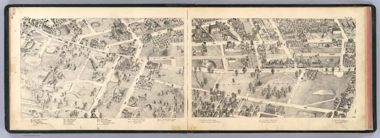
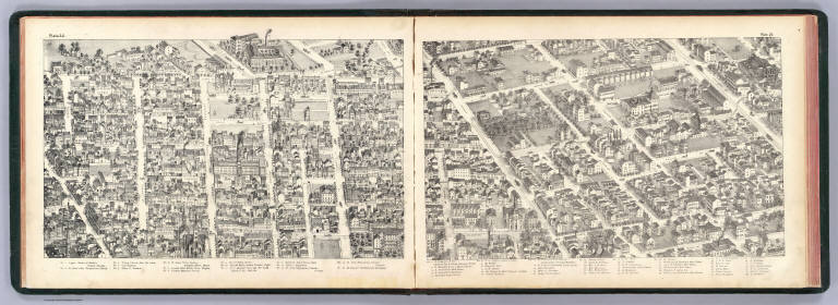
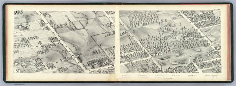
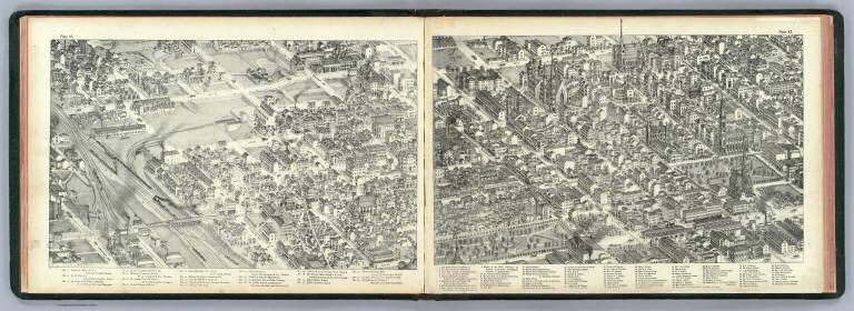
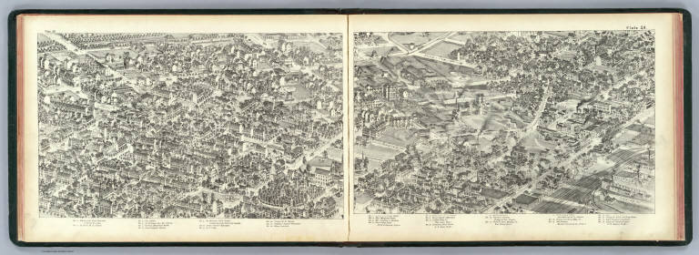
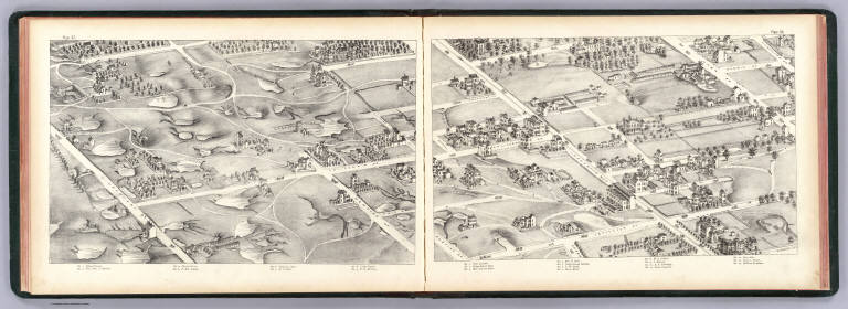
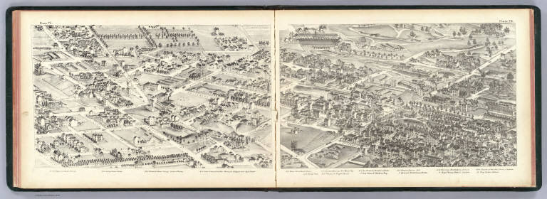
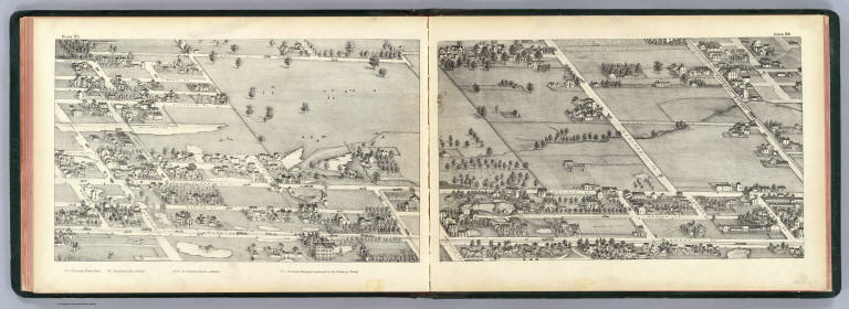
|
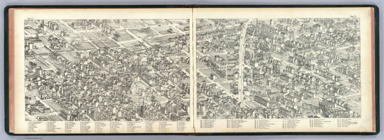
Author
[Compton, Richard J., Dry, Camille N.]
Full Title
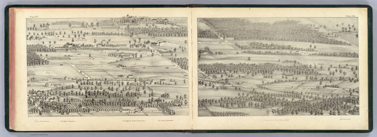
(Pictorial St. Louis) plate 1, plate 2. C.N. Dry. Entered ... 1874 by Compton & Company ... Washington, D.C.
List No
4209.003
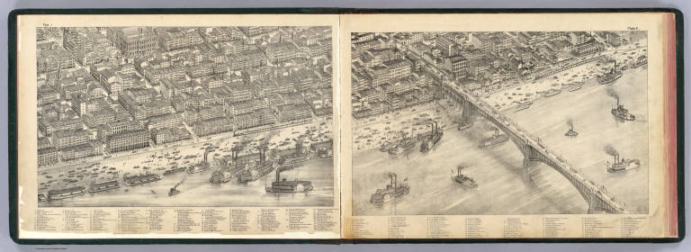
Note
Two facing lithographed views. Covers area inland from the levee between Elm and Wash streets including the Eads Bridge. Shows boats, wagons, pedestrians, etc. Includes keys to buildings.
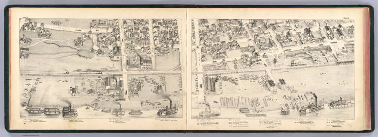
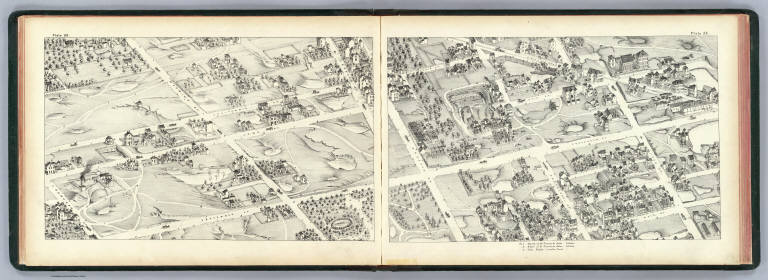
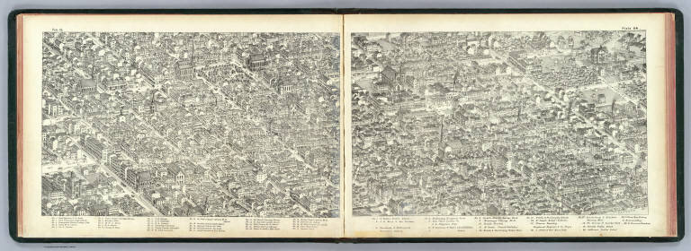
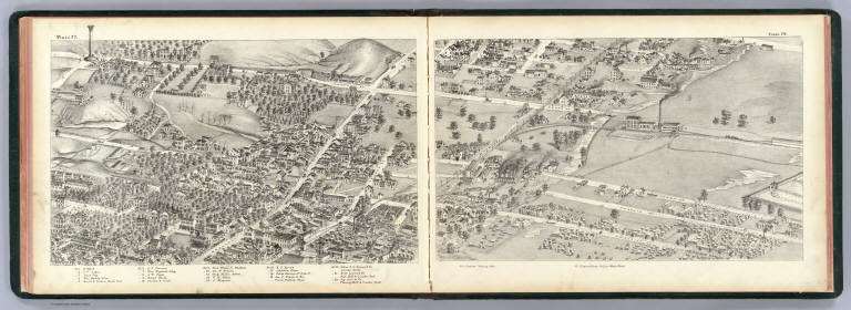
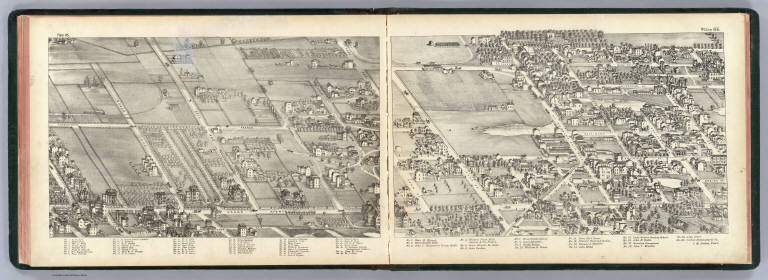
Author
[Compton, Richard J., Dry, Camille N.]
Full Title
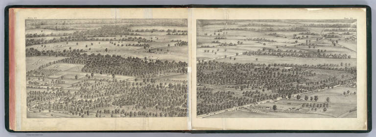
(Pictorial St. Louis) plate 3, plate 4. (By C.N. Dry, 1876)
List No
4209.004
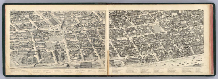
Note
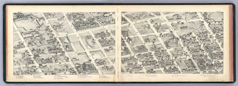
Two facing lithographed views. Covers area roughly Levee to 7th St. between Convent and Myrtle streets. Shows boats, wagons, trains, trolleys, pedestrians, etc. Includes keys to buildings.
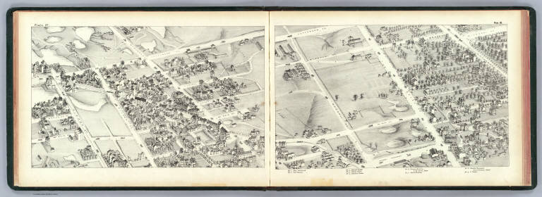
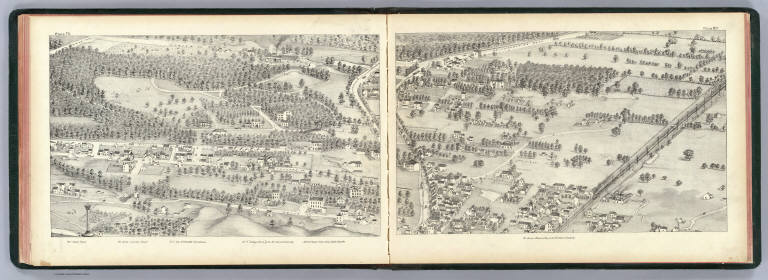
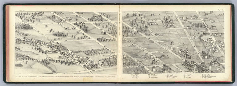
Author
[Compton, Richard J., Dry, Camille N.]
Full Title
(Pictorial St. Louis) plate 5, plate 6. (By C.N. Dry, 1876)
List No
4209.005
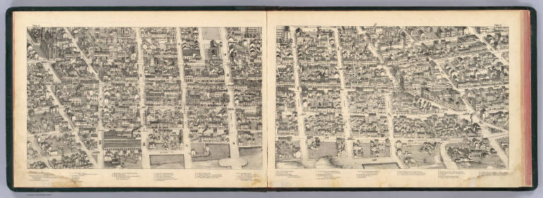
Note
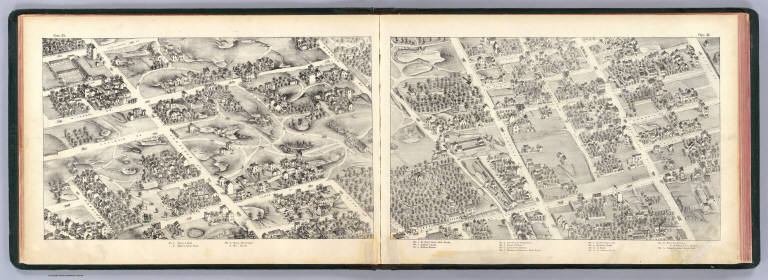
Two facing lithographed views. Shows wagons, trolleys, pedestrians, etc. Includes keys to buildings.
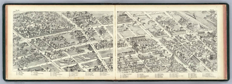
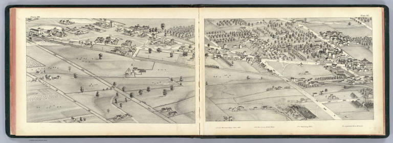
Author
[Compton, Richard J., Dry, Camille N.]
Full Title
(Pictorial St. Louis) plate 7, plate 8. (By C.N. Dry, 1876)
List No
4209.006
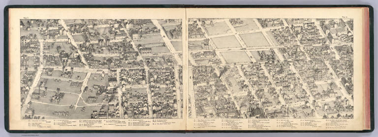
Note
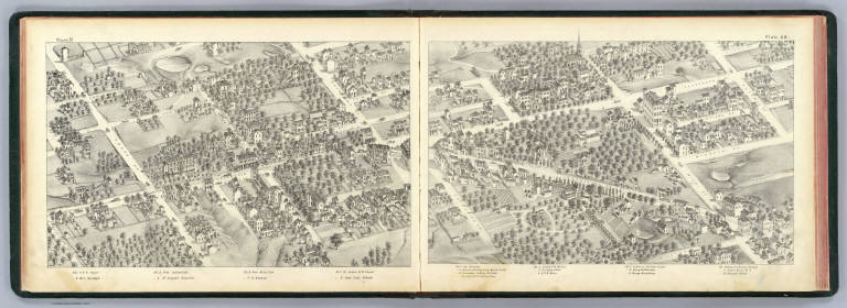
Two facing lithographed views. Shows wagons, trolleys, pedestrians, etc. Includes keys to buildings.
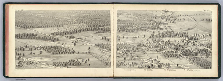
Author
[Compton, Richard J., Dry, Camille N.]
Full Title
(Pictorial St. Louis) plate 9, plate 10. (By C.N. Dry, 1876)
List No
4209.007
Note
Two facing lithographed views. Shows wagons, trolleys, pedestrians, etc. Includes keys to buildings.
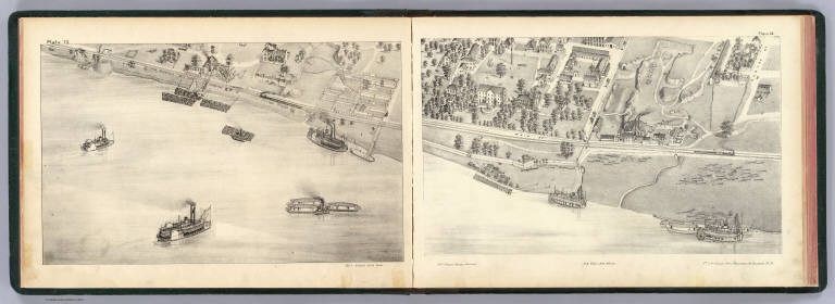
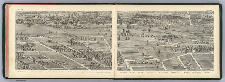
Author
[Compton, Richard J., Dry, Camille N.]
Full Title
(Pictorial St. Louis) plate 11, plate 12. (By C.N. Dry, 1876)
List No
4209.008
Note
Two facing lithographed views. Shows boats, wagons, trains, workers, etc. Includes keys to buildings.
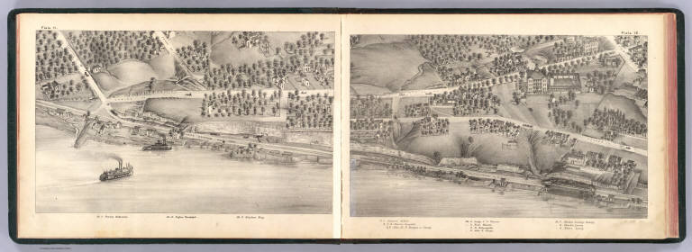
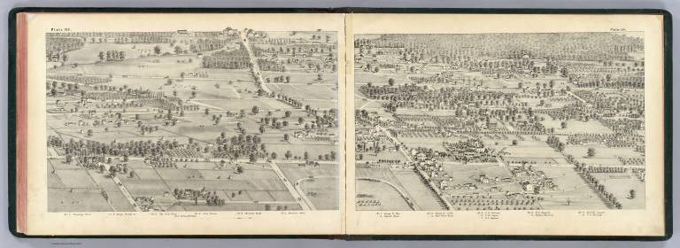
Author
[Compton, Richard J., Dry, Camille N.]
Full Title
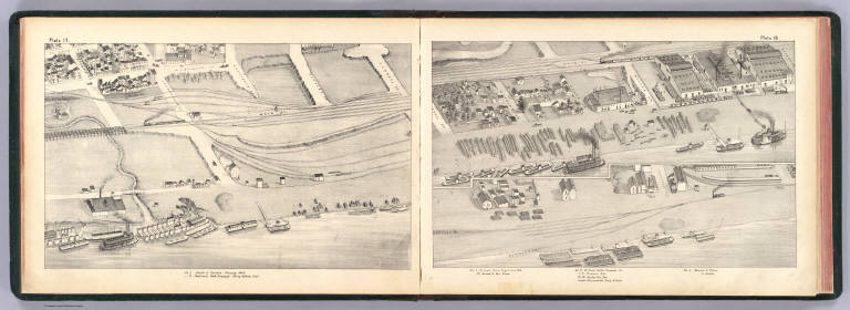
(Pictorial St. Louis) plate 13, plate 14. (By C.N. Dry, 1876)
List No
4209.009
Note
Two facing lithographed views. Shows boats, wagons, trains, soldiers, etc. Covers United States Arsenal and stockyard and Tudor Iron works. Includes keys to buildings.
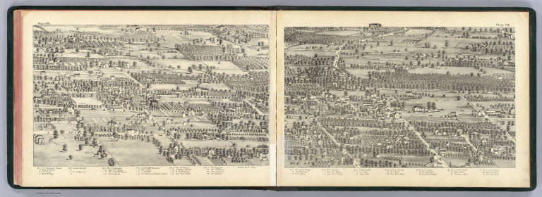
Author
[Compton, Richard J., Dry, Camille N.]
Full Title
(Pictorial St. Louis) plate 15, plate 16. (By C.N. Dry, 1876)
List No
4209.010
Note
Two facing lithographed views. Shows boats, wagons, trains, etc. Includes keys to buildings.
Author
[Compton, Richard J., Dry, Camille N.]
Full Title
(Pictorial St. Louis) plate 17, plate 18. (By C.N. Dry, 1876)
List No
4209.011
Note
Two facing lithographed views. Shows boats, wagons, trains, etc. Includes keys to buildings.
Author
[Compton, Richard J., Dry, Camille N.]
Full Title
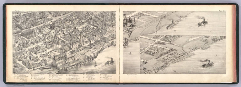
(Pictorial St. Louis) plate 19, plate 20. (By C.N. Dry, 1876)
List No
4209.012
Note
Two facing lithographed views. Shows boats, wagons, trains, trolleys, etc. Includes keys to buildings and inset view.
Author
[Compton, Richard J., Dry, Camille N.]
Full Title
(Pictorial St. Louis) plate 21, plate 22. (By C.N. Dry, 1876)
List No
4209.013
Note
Two facing lithographed views. Shows wagons, trolleys, etc. Covers area generally bounded by Main, O'Fallon, 10th and Market. Includes keys to buildings.
Author
[Compton, Richard J., Dry, Camille N.]
Full Title
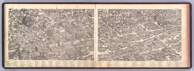
(Pictorial St. Louis) plate 23, plate 24. (By C.N. Dry, 1876)
List No
4209.014
Note
Two facing lithographed views. Shows wagons, trolleys, trains, freight depots, grain elevator, etc. Covers area generally bounded by 5th, Pine, 13th and Chouteau. Includes keys to buildings.
Author
[Compton, Richard J., Dry, Camille N.]
Full Title
(Pictorial St. Louis) plate 25, plate 26. (By C.N. Dry, 1876)
List No
4209.015
Note
Two facing lithographed views. Shows wagons, trolleys, factories, etc. Covers area generally bounded by 8th, Papin, St. Ange, Linn and Geyer. Includes keys to buildings.
Author
[Compton, Richard J., Dry, Camille N.]
Full Title
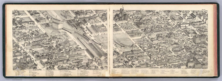
(Pictorial St. Louis) plate 27, plate 28. (By C.N. Dry, 1876)
List No
4209.016
Note
Two facing lithographed views. Shows wagons, trolleys, breweries etc. Covers area generally bounded by Buel, Geyer, Second Carondelet and Lynch. Includes keys to buildings.
Author
[Compton, Richard J., Dry, Camille N.]
Full Title
(Pictorial St. Louis) plate 29, plate 30. (By C.N. Dry, 1876)
List No
4209.017
Note
Two facing lithographed views. Shows wagons, brickyards, breweries etc. Covers area generally bounded by Second Carondelet , Lynch, Jefferson and President. Includes residence of A. Busch, E. Anheuser & Co., Bavarian Brewery and keys to buildings.
Author
[Compton, Richard J., Dry, Camille N.]
Full Title
(Pictorial St. Louis) plate 31, plate 32. (By C.N. Dry, 1876)
List No
4209.018
Note
Two facing lithographed views. Shows wagons, trolleys, Bavarian Branch Brewery, etc. Covers area generally bounded by Wisconsin, Potomac, California and Gasconade. Includes keys to buildings.
Author
[Compton, Richard J., Dry, Camille N.]
Full Title
(Pictorial St. Louis) plate 33, plate 34. (By C.N. Dry, 1876)
List No
4209.019
Note
Two facing lithographed views. Shows wagons, Cherokee Brewery, Cherokee Garden, etc. Covers area generally bounded by Clara, Cherokee, Virginia and Keokuk. Includes key to buildings.
Author
[Compton, Richard J., Dry, Camille N.]
Full Title
(Pictorial St. Louis) plate 35, plate 36. (By C.N. Dry, 1876)
List No
4209.020
Note
Two facing lithographed views. Shows wagons, church and school of St. Francis de Sales, Theo. Bloes's lumber yard, city park, etc. Covers area generally bounded by McNair, Lynch, California and Cherokee. Includes key to buildings.
Author
[Compton, Richard J., Dry, Camille N.]
Full Title
(Pictorial St. Louis) plate 37, plate 38. (By C.N. Dry, 1876)
List No
4209.021
Note
Two facing lithographed views. Shows wagons, trolleys, etc. Covers area generally bounded by Second Carondelet, Lafayette, Jefferson and Sidney. Includes key to buildings.
Author
[Compton, Richard J., Dry, Camille N.]
Full Title
(Pictorial St. Louis) plate 39, plate 40. (By C.N. Dry, 1876)
List No
4209.022
Note
Two facing lithographed views. Shows wagons, trolleys, train, breweries, quarry, Lafayette Park, etc. Covers area generally bounded by 14th, Randolph, Missouri and Lafayette. Includes keys to buildings.
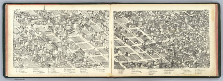
Author
[Compton, Richard J., Dry, Camille N.]
Full Title
(Pictorial St. Louis) plate 41, plate 42. (By C.N. Dry, 1876)
List No
4209.023
Note
Two facing lithographed views. Shows wagons, trolleys, trains, breweries, factories, Washington Park, Missouri Park, Lucas Market, etc. Covers area generally bounded by 11th, Morgan, 18th and Gratiot. Includes keys to buildings.
Author
[Compton, Richard J., Dry, Camille N.]
Full Title
(Pictorial St. Louis) plate 43, plate 44. (By C.N. Dry, 1876)
List No
4209.024
Note
Two facing lithographed views. Shows wagons, trolleys, churches, schools, factories, etc. Covers area generally bounded by 7th, Mullanphy, 17th and Locust. Includes keys to buildings.
Author
[Compton, Richard J., Dry, Camille N.]
Full Title
(Pictorial St. Louis) plate 45, plate 46. (By C.N. Dry, 1876)
List No
4209.025
Note
Two facing lithographed views. Shows boats, wagons, trolleys, trains, lumber yards, factories, etc. Covers area generally bounded by Main, N. Market, 14th and Cass. Includes keys to buildings.
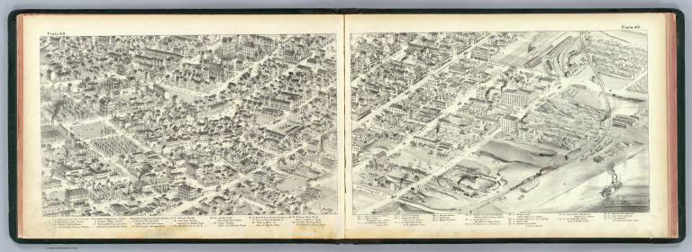
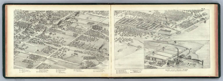
Author
[Compton, Richard J., Dry, Camille N.]
Full Title
(Pictorial St. Louis) plate 47, plate 48. (By C.N. Dry, 1876)
List No
4209.026
Note
Two facing lithographed views. Shows wagons, trolleys, trains, lumber yards, stables, factories, Union Stock Yards, etc. Saint Louis Water Works shown in an inset ("Note: the location adjoins plate 78, not shown in the key"). Covers area generally bounded by the River, Bremen, 9th and Palm. Includes keys to buildings.
Author
[Compton, Richard J., Dry, Camille N.]
Full Title
(Pictorial St. Louis) plate 49, plate 50. (By C.N. Dry, 1876)
List No
4209.027
Note
Two facing lithographed views. Shows wagons, trolleys, churches, houses, factories, etc. Covers area generally bounded by the Broadway, Anglerodt, 17th and Monroe. Includes keys to buildings.
Author
[Compton, Richard J., Dry, Camille N.]
Full Title
(Pictorial St. Louis) plate 51, plate 52. (By C.N. Dry, 1876)
List No
4209.028
Note
Two facing lithographed views. Shows wagons, trolleys, brickyard, lumber yard, quarry, churches, etc. Covers area generally bounded by the 15th, Warren, 25th and Franklin. Includes keys to buildings.
Author
[Compton, Richard J., Dry, Camille N.]
Full Title
(Pictorial St. Louis) plate 53, plate 54. (By C.N. Dry, 1876)
List No
4209.029
Note
Two facing lithographed views. Shows wagons, trolleys, churches, factories, etc. Covers area generally bounded by the 17th, Biddle, Beaumont and Poplar. Includes keys to buildings.
Author
[Compton, Richard J., Dry, Camille N.]
Full Title
(Pictorial St. Louis) plate 55, plate 56. (By C.N. Dry, 1876)
List No
4209.030
Note
Two facing lithographed views. Shows wagons, trolleys, trains, churches, factories, etc. Covers area generally bounded by the Mercer, Walnut, Summit and Park. Includes keys to buildings.
Author
[Compton, Richard J., Dry, Camille N.]
Full Title
(Pictorial St. Louis) plate 57, plate 58. (By C.N. Dry, 1876)
List No
4209.031
Note
Two facing lithographed views. Shows wagons, trolleys, etc. Covers area generally bounded by the Missouri, Caroline, Compton and Russell. Includes keys to buildings.
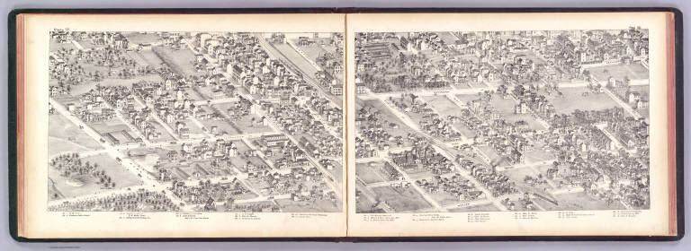
Author
[Compton, Richard J., Dry, Camille N.]
Full Title
(Pictorial St. Louis) plate 59, plate 60. (By C.N. Dry, 1876)
List No
4209.032
Note
Two facing lithographed views. Shows wagons, trolleys, Old Picotte Cemetery, etc. Covers area generally bounded by the Nebraska, Gravois, Victor, Bough and Wyoming. Lacks key.
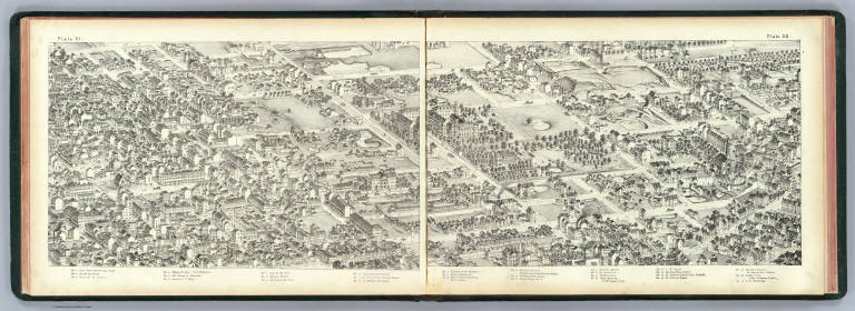
Author
[Compton, Richard J., Dry, Camille N.]
Full Title
(Pictorial St. Louis) plate 61, plate 62. (By C.N. Dry, 1876)
List No
4209.033
Note
Two facing lithographed views. Shows wagons, Gravois Park, farms, houses, etc. Covers area along Gravois Road and Grand Avenue between Wyoming and Chippewa. Lacks key.
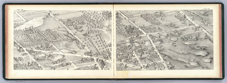
Author
[Compton, Richard J., Dry, Camille N.]
Full Title
(Pictorial St. Louis) plate 63, plate 64. (By C.N. Dry, 1876)
List No
4209.034
Note
Two facing lithographed views. Shows wagons, farms, houses, part of Tower Grove Park, Bamberger's Grove, etc. Covers area along Oak Hill Road and Russell Place between the Park and Gravois Road. Includes keys.
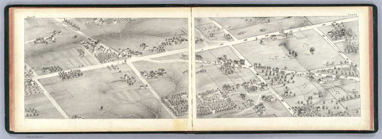
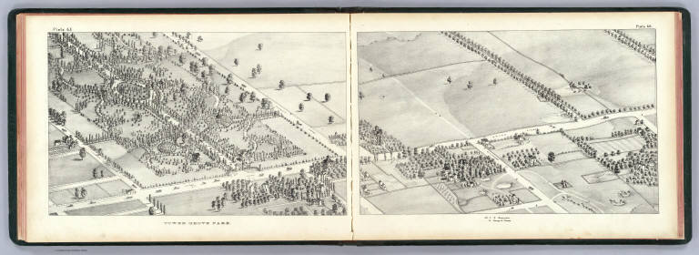
Author
[Compton, Richard J., Dry, Camille N.]
Full Title
(Pictorial St. Louis) plate 65 Tower Grove Park, plate 66. (By C.N. Dry, 1876)
List No
4209.035
Note
Two facing lithographed views. Shows wagons, farms, houses, etc. Plate 66 covers area along Grand Ave. between Russell and Hartford. Includes key.
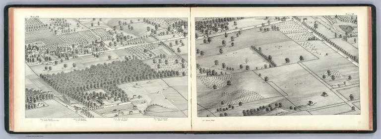
Author
[Compton, Richard J., Dry, Camille N.]
Full Title
(Pictorial St. Louis) plate 67, plate 68. (By C.N. Dry, 1876)
List No
4209.036
Note
Two facing lithographed views. Shows wagons, farms, houses, Compton Hill Reservoir, home of Capt. James B. Eads, etc. Covers area generally bounded by Chouteau, Montrose, Pontiac and Grand. Includes keys.
Author
[Compton, Richard J., Dry, Camille N.]
Full Title
(Pictorial St. Louis) plate 69, plate 70. (By C.N. Dry, 1876)
List No
4209.037
Note
Two facing lithographed views. Shows wagons, farms, houses, Pacific Stock Yards, Red Stocking Ball Park, etc. Covers area generally bounded by Lucas, Summit, Rutger and Grand. Includes keys.
Author
[Compton, Richard J., Dry, Camille N.]
Full Title
(Pictorial St. Louis) plate 71, plate 72. (By C.N. Dry, 1876)
List No
4209.038
Note
Two facing lithographed views. Shows wagons, trolleys, farms, houses, etc. Covers area generally bounded by Cass, Jefferson, Chestnut and Ware. Includes keys.
Author
[Compton, Richard J., Dry, Camille N.]
Full Title
(Pictorial St. Louis) plate 73, plate 74. (By C.N. Dry, 1876)
List No
4209.039
Note
Two facing lithographed views. Shows wagons, trolleys, farms, houses, Saint Louis Hospital, Lindell Park, etc. Covers area generally bounded by Sullivan, 18th, Dayton and Garrison. Includes keys.
Author
[Compton, Richard J., Dry, Camille N.]
Full Title
(Pictorial St. Louis) plate 75, plate 76. (By C.N. Dry, 1876)
List No
4209.040
Note
Two facing lithographed views. Shows wagons, trolleys, farms, brick works, brewery, houses, etc. Covers area generally bounded by Angelica, 10th, St. Louis and 25th. Includes keys.
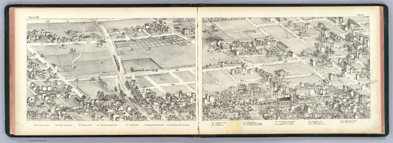
Author
[Compton, Richard J., Dry, Camille N.]
Full Title
(Pictorial St. Louis) plate 77, plate 78. (By C.N. Dry, 1876)
List No
4209.041
Note
Two facing lithographed views. Shows wagons, trolleys, farms, brick and lumber yards, Laclede Rolling Mill, Engine House St. Louis Water Works, etc. Covers area generally bounded by Gano, Riverfront, Bremen and 19th. Includes keys.
Author
[Compton, Richard J., Dry, Camille N.]
Full Title
(Pictorial St. Louis) plate 79, plate 80. (By C.N. Dry, 1876)
List No
4209.042
Note
Two facing lithographed views. Shows wagons, trolleys, farms, water tower, "College Farm" of St. Louis University, O'Fallon Park, St. Louis, Kansas City and Northern Railway, present Bellefontaine Cemetery area, etc. Includes keys.
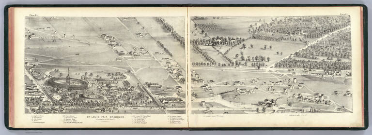
Author
[Compton, Richard J., Dry, Camille N.]
Full Title
(Pictorial St. Louis) plate 81 St., Louis Fair Grounds, plate 82. (By C.N. Dry, 1876)
List No
4209.043
Note
Two facing lithographed views. Shows wagons, trolleys, farms, Carter and O'Fallon homesteads, Fairground Park, part of O'Fallon Park, etc. Includes keys.
Author
[Compton, Richard J., Dry, Camille N.]
Full Title
(Pictorial St. Louis) plate 83, plate 84. (By C.N. Dry, 1876)
List No
4209.044
Note
Two facing lithographed views. Shows wagons, trolleys, farms, St. Louis Hospital, etc. Covers area generally bounded by Natural Bridge, Grand, Boston and Lamplin. Includes key.
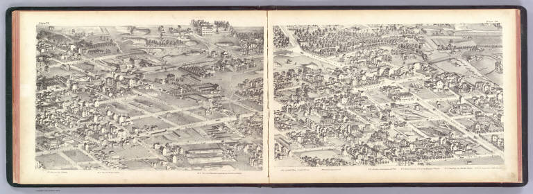
Author
[Compton, Richard J., Dry, Camille N.]
Full Title
(Pictorial St. Louis) plate 85, plate 86. (By C.N. Dry, 1876)
List No
4209.045
Note
Two facing lithographed views. Shows wagons, trolleys, farms, etc. Covers area generally bounded by North Market, Grand, Washington and Warne. Includes keys.
Author
[Compton, Richard J., Dry, Camille N.]
Full Title
(Pictorial St. Louis) plate 87, plate 88. (By C.N. Dry, 1876)
List No
4209.046
Note
Two facing lithographed views. Shows wagons, trolleys, train, farms, etc. Covers area generally bounded by Washington, Theresa, Forest Park and Boyle. Includes keys.
Author
[Compton, Richard J., Dry, Camille N.]
Full Title
(Pictorial St. Louis) plate 89, plate 90. (By C.N. Dry, 1876)
List No
4209.047
Note
Two facing lithographed views. Shows wagons, train, farms, St. Bernhard Chapel, Rock Spring School House, Rock Spring Hotel, Hydraulic Press-Brick Co., etc. Covers area along Manchester and New Manchester between Forest Park and McRee. Includes keys.
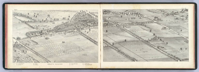
Author
[Compton, Richard J., Dry, Camille N.]
Full Title
(Pictorial St. Louis) plate 91 Shaw's Garden, plate 92. (By C.N. Dry, 1876)
List No
4209.048
Note
Two facing lithographed views. Shows wagons, train, fields, etc. Includes key.
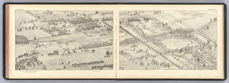
Author
[Compton, Richard J., Dry, Camille N.]
Full Title
(Pictorial St. Louis) plate 93, plate 94. (By C.N. Dry, 1876)
List No
4209.049
Note
Two facing lithographed views. Shows wagons, fields, Tower Grove Park, Russell's Coal Mines, etc. Includes key.
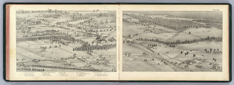
Author
[Compton, Richard J., Dry, Camille N.]
Full Title
(Pictorial St. Louis) plate 95, plate 96. (By C.N. Dry, 1876)
List No
4209.050
Note
Two facing lithographed views. Shows wagons, fields, old and new county poor houses, County Insane Asylum, Social Evil Hospital and Shaw's Schools at Old Manchester Road, Kingshighway and Arsenal Road. Includes keys.
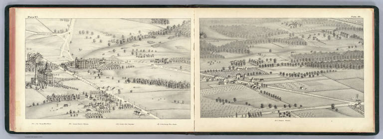
Author
[Compton, Richard J., Dry, Camille N.]
Full Title
(Pictorial St. Louis) plate 97, plate 98. (By C.N. Dry, 1876)
List No
4209.051
Note
Two facing lithographed views. Shows wagons, trains, brick works, smelter, etc. Covers area generally bounded by Clayton, Kingshighway, Pattison and Tamm. Includes key.
Author
[Compton, Richard J., Dry, Camille N.]
Full Title
(Pictorial St. Louis) plate 99, plate 100. (By C.N. Dry, 1876)
List No
4209.052
Note
Two facing lithographed views. Shows wagons, train, Forest Park, etc. Covers area generally bounded by Baker, Cornell, New Manchester and Union. Includes keys.
Author
[Compton, Richard J., Dry, Camille N.]
Full Title
(Pictorial St. Louis) plate 101, plate 102. (By C.N. Dry, 1876)
List No
4209.053
Note
Two facing lithographed views. Shows wagons, train, farms, etc. Covers area generally bounded by Cook, Boyle, Laclede and Union. Includes keys.
Author
[Compton, Richard J., Dry, Camille N.]
Full Title
(Pictorial St. Louis) plate 103, plate 104. (By C.N. Dry, 1876)
List No
4209.054
Note
Two facing lithographed views. Shows wagons, train, farms, Abbey Track, etc. Covers area generally bounded by North Market, Newstead, Bell and Goodfellow. Includes keys.
Author
[Compton, Richard J., Dry, Camille N.]
Full Title
(Pictorial St. Louis) plate 105, plate 106. (By C.N. Dry, 1876)
List No
4209.055
Note
Two facing lithographed views. Shows wagons, farms, etc. Covers area generally bounded by Kossuth, Newstead, St. Louis and Goodfellow. Includes keys.
Author
[Compton, Richard J., Dry, Camille N.]
Full Title
(Pictorial St. Louis) plate 107, plate 108. (By C.N. Dry, 1876)
List No
4209.056
Note
Two facing lithographed views. Shows wagons, farms, grave of Capt. Robert McClellan, etc. Covers area generally bounded by Emma, Union, Margaret and Jennings. Includes keys.
Author
[Compton, Richard J., Dry, Camille N.]
Full Title
(Pictorial St. Louis) plate 109, plate 110. (By C.N. Dry, 1876)
List No
4209.057
Note
Two facing lithographed views. Shows wagons, train, farms, Calvary Cemetery, Bellefontaine Cemetery, Jennings Station, etc. No keys.
Author
Lloyd, H.H.
Full Title
(Covers to) Lloyd's Dollar Map Of The Western States. Published By H.H. Lloyd & Co. 170 Fulton Street, New York. Copyright 1876, by H.H. Lloyd & Co.
List No
4420.001
Note
Shows the area from eastern Ohio to western Nebraska, from the Canadian border south to the 37th parallel. The cartouche is a large United States "Trade Dollar 420 Grains 900 Fine." Railroads lines are shown in profusion, with some roads indicated in the less populated western counties. The progression of settlement to the west and north is clearly shown. The only issue of this map in Karrow. Lloyd also made similar maps of the other U.S. regions (see P-Maps 927). Full color by county. Folded into brown cloth covers 17.5x11 with black oval label reading "Lloyd's "Dollar" Map Series. Western States. H.H. Lloyd & Co., New York." Prime meridian is Washington D.C.
Author
Lloyd, H.H.
Full Title
Lloyd's Dollar Map Of The Western States. Published By H.H. Lloyd & Co. 170 Fulton Street, New York. Copyright 1876, by H.H. Lloyd & Co.
List No
4420.002
Note
Shows the area from eastern Ohio to western Nebraska, from the Canadian border south to the 37th parallel. The cartouche is a large United States "Trade Dollar 420 Grains 900 Fine." Railroads lines are shown in profusion, with some roads indicated in the less populated western counties. The progression of settlement to the west and north is clearly shown. The only issue of this map in Karrow. Lloyd also made similar maps of the other U.S. regions (see P-Maps 927). Full color by county. Folded into brown cloth covers 17.5x11 with black oval label reading "Lloyd's "Dollar" Map Series. Western States. H.H. Lloyd & Co., New York." Prime meridian is Washington D.C.
Author
Traubel, M.H.
Full Title
Map Illustrating The Position Of Duluth In The United States. M.H. Traubel's Lithographic Establishment 409 Chestnut St. Phila.
List No
4443.000
Note
The date is estimated from a similar, smaller map, also printed by Traubel, which is part of a report on the Harbor of Duluth issued in 1876 (see our 3394). A huge area encompassing the Western States and Canada is shaded in pale yellow indicating the "Area Tributary To The Harbor Of Duluth Over 2,000,000 Of Square Miles." This larger map is clearly a separate, unfolded issue on thin paper. It promotes Duluth as the trade center of a vast area of the northwestern U.S. and southwestern Canada ("2,000,000 of Square miles"). It is quite a wonderful map, full of interesting information on climate, mining, railroads, canals, railroads, land grants - all with the unlikely slant of emphasizing Duluth. Karrow lists several related Duluth maps by Traubel (Karrow 7-0191, 7-0193, 7-0198, 7-0793). Full color by state.
Author
Beers, F.W.
Full Title
(Covers) Illustrated Atlas of the City of Richmond, Published for the Southern and Southwestern Surveying and Pub. Co. by F.W. Beers, C.E. J.A. Enslow, Jr., J.P. Brown, Business Managers ... Entered ... 1876 by F.W. Beers ... Washington ...
List No
4623.001
Note
Atlas is bound in half leather dark brown cloth covered boards with "Illustrated Combination Atlas Of Richmond, Va. 1876." decoratively embossed in gilt on the front and back covers.
Author
Beers, F.W.
Full Title
(Title Page) Illustrated Atlas Of The City Of Richmond, Va. Published for the Southern and Southwestern Surveying and Pub. Co. By F.W. Beers, C.E. J.A. Enslow, Jr., J.P. Brown, Business Managers ... Entered ... 1876 by F.W. Beers ... Washington ...
List No
4623.002
Note
The title page is illustrated with a view of the Custom House and Post Office. Repairs to the title page.
Author
Beers, F.W.
Full Title
(Table of Contents) Illustrated Atlas Of The City Of Richmond, Va. Published for the Southern and Southwestern Surveying and Pub. Co. By F.W. Beers, C.E. J.A. Enslow, Jr., J.P. Brown, Business Managers ... Entered ... 1876 by F.W. Beers ... Washington ...
List No
4623.003
Note
Repairs to Table of Contents page.
Author
Beers, F.W.
Full Title
Outline (Index) Map of Cities of Richmond and Manchester and Vicinity, Accompanying the Atlas of Richmond, Va.
List No
4623.004
Note
Includes concentric circles a quarter mile apart centered on the Capitol. Red rectangles are keyed to show the footprints of maps in the atlas.
Author
Beers, F.W.
Full Title
Section A. (Richmond, Va.)
List No
4623.005
Note
For index map showing the footprint of this map see "list number" 4623.004.
Author
Beers, F.W.
Full Title
Section B. (Richmond, Va.)
List No
4623.006
Note
For index map showing the footprint of this map see "list number" 4623.004.
Author
Beers, F.W.
Full Title
Section C. (Richmond, Va.)
List No
4623.007
Note
For index map showing the footprint of this map see "list number" 4623.004. NOTE: There is no "Section D" on the index or among the sheets.
Author
Beers, F.W.
Full Title
Section E. (Richmond, Va.)
List No
4623.008
Note
For index map showing the footprint of this map see "list number" 4623.004.
Author
Beers, F.W.
Full Title
Section F. (Richmond, Va.)
List No
4623.009
Note
For index map showing the footprint of this map see "list number" 4623.004.
Author
Beers, F.W.
Full Title
Section G. (Richmond, Va.)
List No
4623.010
Note
For index map showing the footprint of this map see "list number" 4623.004.
Author
Beers, F.W.
Full Title
Section H. (Richmond, Va.)
List No
4623.011
Note
For index map showing the footprint of this map see "list number" 4623.004.
Author
Beers, F.W.
Full Title
Section I. (Richmond, Va.)
List No
4623.012
Note
Relief shown in hachures. For index map showing the footprint of this map see "list number" 4623.004.
Author
Beers, F.W.
Full Title
Section J. (Richmond, Va.)
List No
4623.013
Note
For index map showing the footprint of this map see "list number" 4623.004.
Author
Beers, F.W.
Full Title
Section K. (Richmond, Va.)
List No
4623.014
Note
For index map showing the footprint of this map see "list number" 4623.004.
Author
Beers, F.W.
Full Title
Section L. (Richmond, Va.)
List No
4623.015
Note
For index map showing the footprint of this map see "list number" 4623.004.
Author
Beers, F.W.
Full Title
Section M. (Richmond, Va.)
List No
4623.016
Note
For index map showing the footprint of this map see "list number" 4623.004.
Author
Beers, F.W.
Full Title
Section N. (Richmond, Va.)
List No
4623.017
Note
For index map showing the footprint of this map see "list number" 4623.004.
Author
Beers, F.W.
Full Title
Section O. (Richmond, Va.)
List No
4623.018
Note
Repairs to Section O page. For index map showing the footprint of this map see "list number" 4623.004.
Author
Beers, F.W.
Full Title
Belle Isle. (Richmond, Va.)
List No
4623.019
Note
Repairs to Belle Isle page. For index map showing the footprint of this map see "list number" 4623.004.
Author
Beers, F.W.
Full Title
Section P. (Richmond, Va.)
List No
4623.020
Note
For index map showing the footprint of this map see "list number" 4623.004.
Author
Beers, F.W.
Full Title
Section Q. (Richmond, Va.)
List No
4623.021
Note
For index map showing the footprint of this map see "list number" 4623.004.
Author
Beers, F.W.
Full Title
Section R. Part of Manchester, Chesterfield Co. Va.
List No
4623.022
Note
For index map showing the footprint of this map see "list number" 4623.004.
Author
Beers, F.W.
Full Title
Section S. Part of Manchester, Chesterfield Co. Va.
List No
4623.023
Note
For index map showing the footprint of this map see "list number" 4623.004.
Author
Beers, F.W.
Full Title
Section T. Part of Manchester, Chesterfield Co. Va.
List No
4623.024
Note
For index map showing the footprint of this map see "list number" 4623.004.
Author
Beers, F.W.
Full Title
(Composite of) Richmond, Va.
List No
4623.025
Author
Beers, F.W.
Full Title
(Composite of) Manchester, Va.
List No
4623.026
Author
[Beers, F.W. (Frederick W.), Cramer, Louis H.]
Full Title
(Covers to) Combination Atlas Of Saratoga And Ballston From Recent And Actual Surveys And Records Under the Superintendence of F.W. Beers And Louis H. Cramer, Published By J.B. Beers & Co. 36 Vesey Street, New York. 1876. Entered ... 1876 by J.W. Beers & Co. ... Washington. Printed by Charles Hart, 36 Vesey St. N.Y. Engraved by L.E. Neuman 36 Vesey St. N.Y.
List No
4629.001
Note
Atlas is bound in full black leather covered boards with "Combiination Atlas Of Saratoga And Ballston. F.W. Beers And Louis H. Cramer. 1876" stamped in gold.
Author
[Beers, F.W. (Frederick W.), Cramer, Louis H.]
Full Title
(View) (Watercolor painting of cherries and daisies).
List No
4629.002
Note
Bound in but not a part of original publication.
Author
[Beers, F.W. (Frederick W.), Cramer, Louis H.]
Full Title
(Title Page) Combination Atlas Of Saratoga And Ballston From Recent And Actual Surveys And Records Under the Superintendence of F.W. Beers And Louis H. Cramer, Published By J.B. Beers & Co. 36 Vesey Street, New York. 1876. Entered ... 1876 by J.W. Beers & Co. ... Washington. Printed by Charles Hart, 36 Vesey St. N.Y. Engraved by L.E. Neuman 36 Vesey St. N.Y.
List No
4629.003
Author
[Beers, F.W. (Frederick W.), Cramer, Louis H.]
Full Title
(Table of Contents) Illustrations. (Index Maps).
List No
4629.004
Author
[Beers, F.W. (Frederick W.), Cramer, Louis H.]
Full Title
Plan of Saratoga Co., New York.
List No
4629.005
Author
[Beers, F.W. (Frederick W.), Cramer, Louis H.]
Full Title
(View) Res. of W.C. Bronson, North Broadway, Saratoga Springs, N.Y. Temple Grove Seminary, Saratoga Springs, N.Y. Circular Street View, Chas. F. Dowd A.M. Principal. (inset) Spring St. View.
List No
4629.006
Author
[Beers, F.W. (Frederick W.), Cramer, Louis H.]
Full Title
Sheet 1. Map of Saratoga Springs. From Surveys by Louis H. Cramer. Civil Engineer, 20 & 21 Ainsworth Place, Saratoga Springs.
List No
4629.007
Author
[Beers, F.W. (Frederick W.), Cramer, Louis H.]
Full Title
Sheet 2. Map of Saratoga Springs. From Surveys by Louis H. Cramer. Civil Engineer, 20 & 21 Ainsworth Place, Saratoga Springs.
List No
4629.008
Author
[Beers, F.W. (Frederick W.), Cramer, Louis H.]
Full Title
Sheet 3. Map of Saratoga Springs. From Surveys by Louis H. Cramer. Civil Engineer, 20 & 21 Ainsworth Place, Saratoga Springs.
List No
4629.009
Author
[Beers, F.W. (Frederick W.), Cramer, Louis H.]
Full Title
Sheet 4. Map of Saratoga Springs. From Surveys by Louis H. Cramer. Civil Engineer, 20 & 21 Ainsworth Place, Saratoga Springs.
List No
4629.010
Author
[Beers, F.W. (Frederick W.), Cramer, Louis H.]
Full Title
Sheet 5. Map of Saratoga Springs. From Surveys by Louis H. Cramer. Civil Engineer, 20 & 21 Ainsworth Place, Saratoga Springs.
List No
4629.011
Author
[Beers, F.W. (Frederick W.), Cramer, Louis H.]
Full Title
(View) Ainsworth Place, Broadway Saratoga. Ainsworth Buildings, Saratoga N.Y. Town Hall, Saratoga. First National Bank, Saratoga. Commercial National Park, Saratoga NY. Views of Portions of Broadway, Saratoga Springs, N.Y.
List No
4629.012
Author
[Beers, F.W. (Frederick W.), Cramer, Louis H.]
Full Title
Sheet 6. Map of Saratoga Springs. From Surveys by Louis H. Cramer. Civil Engineer, 20 & 21 Ainsworth Place, Saratoga Springs.
List No
4629.013
Author
[Beers, F.W. (Frederick W.), Cramer, Louis H.]
Full Title
(View) Medical Institute, T.E. Allen, M.D. Proprietor, Circular Street, Saratoga Springs, N.Y. Residence of Seymour Ainsworth, Esq., Saratoga Springs. Stevens & Vaugh Arct.
List No
4629.014
Author
[Beers, F.W. (Frederick W.), Cramer, Louis H.]
Full Title
Sheet 7. Map of Saratoga Springs. From Surveys by Louis H. Cramer. Civil Engineer, 20 & 21 Ainsworth Place, Saratoga Springs.
List No
4629.015
Author
[Beers, F.W. (Frederick W.), Cramer, Louis H.]
Full Title
(View) Res. of Charles Reed, Union Av., Saratoga Springs N.Y. H.P. Share, Del.
List No
4629.016
|