|
Author
Nicholson, W.L.
Full Title
(Covers to) Post Route Map of the States of New Hampshire, Vermont, Massachusetts, Rhode Island, Connecticut and Parts of New York and Maine. By W.L. Nicholson, Topographer of P.O. Department. 1866. 1873.
List No
12127.001
Note
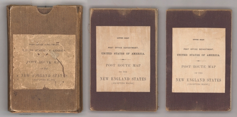
Light brown cardboard slip cover with label with black text reading, "Post Office Department, United States of America. Post Route Map of the New England States (Excepting Maine)." Two panels on each of the two parts making up the map are backed with cloth and have the above label. One label includes "Upper Half.", the other "Lower Half."
Author
Nicholson, W.L.
Full Title
Post Route Map of the States of New Hampshire, Vermont, Massachusetts, Rhode Island, Connecticut and Parts of New York and Maine. By W.L. Nicholson, Topographer of P.O. Department. 1866. (Northern half). 1873
List No
12127.002
Author
Nicholson, W.L.
Full Title
Post Route Map of the States of New Hampshire, Vermont, Massachusetts, Rhode Island, Connecticut and Parts of New York and Maine. By W.L. Nicholson, Topographer of P.O. Department. 1866. (Southern half). 1873
List No
12127.003
Author
Nicholson, W.L.
Full Title
(Composite Map) Post Route Map of the States of New Hampshire, Vermont, Massachusetts, Rhode Island, Connecticut and Parts of New York and Maine. By W.L. Nicholson, Topographer of P.O. Department. 1866. 1873
List No
12127.004
Author
[Spruner von Merz, Karl, 1803-1892., Menke, Heinrich Theodor]
Full Title
Sudwest Deutschland : mit Elsass u. Ostl. Lothringen vor Ausbruch der franzosischen Revolution 1789. Entworfen von Th. Menke u. gez. von B. Hassenstein. Spruner-Menke Hist. Hand-Atlas No. 47. Gotha : Justus Perthes 1873.
List No
13561.073
Note
Map of Southwest Germany with Alsace and eastern Lorraine in 1789.
Author
[Nasmyth, James, Carpenter, James]
Full Title
Plate VII Diagram Of Lunar Craters Forming A series Ranging From 1 3/4 Miles To 78 Miles Diameter, All Containing Central Cones.
List No
15224.013
Note
Page dimensions are full sheet.
Author
[Bartholomew, John, Philip, George]
Full Title
The Pacific States, The Territories And A Portion Of The North-Western States. By J. Bartholomew, F.R.G.S. George Philip & Son, London & Liverpool. (above the title) (United States, No. II (Western Division).
List No
3085.000
Note
Date estimated.
Author
[Bacon, George Washington, Gresswell, Edward, 1797–1869, Mimpriss, Robert]
Full Title
(Covers to) Bacon's family guide to the life and ministry of Christ : illustrated with 100 pictures from the old masters according to Greswells Harmony of the four Evangelists. Delineated by R. Mimpriss. London, G.W. Bacon & Co. John Beardshaw, Cincinnati, Ohio. Entered according to act of Congress in the year of 1873 by John Breadshaw ... Southern District of Ohio.
List No
13454.001
Author
[Bacon, George Washington, Gresswell, Edward, 1797–1869, Mimpriss, Robert]
Full Title
Bacon's family guide to the life and ministry of Christ : illustrated with 100 pictures from the old masters according to Greswells Harmony of the four Evangelists. Delineated by R. Mimpriss. London, G.W. Bacon & Co. John Beardshaw, Cincinnati, Ohio. Entered according to act of Congress in the year of 1873 by John Breadshaw ... Southern District of Ohio.
List No
13454.002
Author
[France. Ministère des travaux publics. Administration des routes, France. Direction des cartes, plans et archives et de la statistique graphique, École nationale des ponts et chaussées (France)]
Full Title
Constnatinople. (1873). 5e Série. Pl. XII. Ministère des Travaux Publics. Ecole des Ponts et Chaussées. Lith. A. Simon, 13, R. du Val-de-Grâce. Paris.
List No
14306.129
Note
Map showing the port of Constnatinople [Istanbul], Turkey, in 1873. Features topography, railways, streets, bridges, drainage, docks and soundings, with depths given in meters. Includes a bar scale. Descriptive text throughout. Lithograph in black, white and blue. With inset map: [Bosphore]. Together, maps are 32 x 46 cm, on fold-out sheet 38 x 50 cm. Bookplate title pasted to verso: Pl. XII. Constantinople. Appears in Cinquième livraison.
Author
Stieler, Adolf, 1775–1836
Full Title
(Title to) Karte der Alpen aus Mayr's Alpen - Atlas : zusammengestellt und vollständig umgearbeitet von Dr. Herm. Berghaus. Acht colorirte Blatter. Gotha : Justus Perthes. 1873.
List No
13563.003
Note
Title page to 1873 map of Alps, from Mayr's Alpen - Atlas: in 8 color maps, compiled and completely revised by Hermmann Berghaus. Published by J. Perther in 1873. Includes inset: "Karte der Alpen".
Author
Spielmann and Brush
Full Title
Map of a tract of land commonly called the Hermitage : Situated in the ninth ward of the City of New York ... Compiled from authentic surveys February 1825 by Daniel Eiven City Surveyor. Published by Spielmann & Brush, civil engineers, Hoboken, N.J. 1881. Copied in the Registrer's Office January 2nd. 1873. (to accompany) Certified copies of original maps of property in New York City.
List No
13338.011
Note
Hand colored cadastral map. Includes notes and names of adjoining landholders. "Showing the same a subdivided into lots on the intersecting avenues and streets". Oriented with north to the upper center.
Author
[Smith, William, 1813-1893, Muller, Charles]
Full Title
The world as known to ancients. Drawn by Dr. Charles Muller. Engraved by Edwd. Weller. London : John Murray. 1873. (to accompany) Dr. William Smith's Ancient atlas. 2. 1874.
List No
13007.022
Note
Outline hand color map of the world. Shows major cities, rivers and mountains. Relief shown by hachures. Roman Empire shown in red outline.
Author
[Smith, William, 1813-1893, Muller, Charles]
Full Title
Empires of the Babylonians, Lydians, Medes and Persians. Drawn by Dr. Charles Muller. Engraved by Edwd. Weller. London : John Murray. 1873. (to accompany) Dr. William Smith's Ancient atlas. 3. 1874.
List No
13007.023
Note
Outline hand color map of the ancient empires of the Middle East: Media, Babylonia, Lydia, and Persia. Shows major cities, rivers and mountains. Relief shown by hachures. Includes color coded reference to Empires.
Author
[Smith, William, 1813-1893, Muller, Charles]
Full Title
Empire of Alexander the Great. Drawn by Dr. Charles Muller. Engraved by Edwd. Weller. London : John Murray. 1873. (to accompany) Dr. William Smith's Ancient atlas. 4. 1874.
List No
13007.024
Note
Outline hand color map. Covers the entire extent of Alexander the Great's domain. Shows major cities, rivers and mountains. Relief shown by hachures. Includes color coded reference to March of Alexander and Course of the fleet.
Author
Wisner de Morgenstern, Francois, 1804-1878
Full Title
(Composite Map) Carte Topographique de la Republique du Paraguay. Carte originale vaite de 1846 a 1858 par des procedees triganometriques et astronomiques dedie au honorable Congres Legilative de la Nation par le Colonel du Genie Francois Wisner de Morgenstern . . . 1873.
List No
12362.003
Author
Gray, O.W.
Full Title
Gray's Atlas Map of Africa.
List No
0310.028
Author
Gray, O.W.
Full Title
Gray's Atlas Map of New York City.
List No
0310.042
Author
Rand McNally & Co.
Full Title
Rand McNally & Co.'s sectional map of the Dakota and the Black Hills. Printed expressly for J. Bride & Co.'s Great American 25 Cent package, 767 and 769 Broadway, New York City. A.W. Barber, Del. Rand McNally & Co. Printers, engravers and electrotypers, 79 Madison Street, Chicago. (with 8 insets). (on verso) Rand McNally & Co.'s new railway guide map.
List No
6878.001
Note
This is one of the earliest Rand McNally maps that we have seen. The date of 1873 is determined from the only date on the map, in the inset map of Cincinnati. Uncolored sectional map with 8 insets: New mining map of Utah, St. Louis, Railroads around Baltimore and Washington, Philadelphia, New York and vicinity, Chicago, Railroad around Cincinnati, 1872-3, Denver. Showing boundaries of township, counties, states and territories, and detail diagram of township numbering system. Includes references, illustrations and advertisements. Relief shown by hachures. Prime meridian is Greenwich.
Author
Rand McNally & Co.
Full Title
Rand McNally & Co.'s new railway guide map. Printed expressly for J. Bride & Co.'s Great American 25 Cent package, 767 and 769 Broadway, New York City. A.W. Barber, Del. Rand McNally & Co. Printers, engravers and electrotypers, 79 Madison Street, Chicago. (with 2 insets). (on verso) Rand McNally & Co.'s sectional map of the Dakota and the Black Hills.
List No
6878.002
Note
Uncolored map with 2 insets: Vicinity of Boston, Map of the Territories and Pacific Coast. Includes illustrations. Relief shown by hachures. This is one of the earliest Rand McNally maps that we have seen. The date of 1873 is determined from the only date on the map, in the inset map of Cincinnati. Uncolored sectional map with 8 insets: New mining map of Utah, St. Louis, Railroads around Baltimore and Washington, Philadelphia, New York and vicinity, Chicago, Railroad around Cincinnati, 1872-3, Denver. Showing boundaries of township, counties, states and territories, and detail diagram of township numbering system. Includes references, illustrations and advertisements. Relief shown by hachures. Prime meridian is Greenwich.
Author
[California Geological Survey, Hoffmann, Charles F., Whitney, J.D.]
Full Title
(Composite) Topographical Map of Central California Together With a Part of Nevada. (Sheets I, II, III & IV). State Geological Survey Of California. J.D. Whitney, State Geologist. C.F. Hoffmann, Principal Topographer, V. Wackenreuder, J.T. Gardner, A. Craven, A.D. Wilson, Field Assistants. 1873 ... Julius Bien, Engr.
List No
2546.006
Note
Four sheets. South 2 sheets of 4; top 2 sheets apparently were never issued but were printed. Four unmounted sheets on heavy paper. Never folded.
Author
Bancroft, A.L.
Full Title
Bancroft's Map Of California, Nevada, Utah And Arizona. Published By A.L. Bancroft & Compy. Booksellers & Stationers, San Francisco, Cal. 1873. Entered ... by A.L. Bancroft & Company ... Washington, D.C.
List No
0046.000
Note
1st edition was 1864. From Bancroft's Map the of Pacific States which appeared in 1863. Wheat says Bancroft changed the large Pacific States map in 1870, but we believe that the smaller maps such as this continue to be from the original 1863 or 1867 plates, updated to show railroad expansion and topographical changes. With black top and bottom rollers. Full color by county.
Author
United States. Congress
Full Title
Map Of The San Joaquin, Sacramento And Tulare Valleys, State Of California, prepared under the direction of the Board Of Commissioners On Irrigation appointed under the Act of Congress approved March 3rd 1873, showing the country that may be irrigated and a Provisional System Of Irrigation Compiled from the Maps of the Geological Survey Of California and from Special Surveys and Examinations. 1873. Published by authority of the Hon. Secretary of War in the Office of the Chief of Engineers U.S. Army.
List No
4916.000
Note
This is another copy of the map that appears in the 1874 "Irrigation of the San Joaquin, Tulare, and Sacramento Valleys, in the State of California." (43rd Cong., 1st Sess., House Doc. No. 290). See our #1061. Printed in full color.
Author
[Hoffmann, Charles F., Whitney, J.D., Geological Survey of California]
Full Title
(Covers to) State Geological Survey Of California. J.D. Whitney, State Geologist. Map Of The Region Adjacent To The Bay Of San Francisco. 1873. The Coast, Rancho, Township and Section Lines from Materials furnished by the U.S. Coast Survey and the U.S. Surveyor General's Office, the Topography chiefly from Original Surveys by C.F. Hoffman ... Julius Bien, Lith.
List No
5806.001
Note
C.F. Hoffmann was the prinicpal topographer; 1st issue was 1867. No mention of the 1873 date in any references. Two sheets printed on thin paper, folded into green covers. Outline color.
Author
[Hoffmann, Charles F., Whitney, J.D., Geological Survey of California]
Full Title
(South Sheet) State Geological Survey Of California. J.D. Whitney, State Geologist. Map Of The Region Adjacent To The Bay Of San Francisco. 1873. The Coast, Rancho, Township and Section Lines from Materials furnished by the U.S. Coast Survey and the U.S. Surveyor General's Office, the Topography chiefly from Original Surveys by C.F. Hoffman ... Julius Bien, Lith.
List No
5806.002
Note
C.F. Hoffmann was the prinicpal topographer; 1st issue was 1867. No mention of the 1873 date in any references. Two sheets printed on thin paper, folded into green covers. Outline color.
Author
[Hoffmann, Charles F., Whitney, J.D., Geological Survey of California]
Full Title
(North Sheet) State Geological Survey Of California. J.D. Whitney, State Geologist. Map Of The Region Adjacent To The Bay Of San Francisco. 1873. The Coast, Rancho, Township and Section Lines from Materials furnished by the U.S. Coast Survey and the U.S. Surveyor General's Office, the Topography chiefly from Original Surveys by C.F. Hoffman ... Julius Bien, Lith.
List No
5806.003
Note
C.F. Hoffmann was the prinicpal topographer; 1st issue was 1867. No mention of the 1873 date in any references. Two sheets printed on thin paper, folded into green covers. Outline color.
Author
[Hoffmann, Charles F., Whitney, J.D., Geological Survey of California]
Full Title
(Composite) State Geological Survey Of California. J.D. Whitney, State Geologist. Map Of The Region Adjacent To The Bay Of San Francisco. 1873. The Coast, Rancho, Township and Section Lines from Materials furnished by the U.S. Coast Survey and the U.S. Surveyor General's Office, the Topography chiefly from Original Surveys by C.F. Hoffman ... Julius Bien, Lith.
List No
5806.004
Note
C.F. Hoffmann was the prinicpal topographer; 1st issue was 1867. No mention of the 1873 date in any references. Two sheets printed on thin paper, folded into green covers. Outline color.
Author
[Austin, H., Whitney, F.]
Full Title
Map Of Marin County, California, Compiled By H. Austin, County Surveyor, from Official Surveys and Records. Drawn By F. Whitney. 1873. (inset) Town Of San Rafael. (inset) Town Of Tomales. (inset) Town Of Nicasio.
List No
0042.000
Note
1st Marin county map - Vogdes. Shows Mexican Land Grants, School Districts, land ownership, towns, topography, roads, railroads, etc. With black top and bottom rollers. Full color by township. Relief shown by hachures. Population and personal property values statistics. Town of San Rafael inset scale 1:7,200. Town of Nicasio inset scale 1:2,400. Mounted on muslin; some portions stained; some portion of Marin Headlands area (Golden Gate) missing.
Author
Bancroft, A.L.
Full Title
(Covers to) Bancroft's Official Guide Map Of City And County Of San Francisco, Compiled From Official Maps In Surveyor's Office. Published by A.L. Bancroft & Co. ... San Francisco, 1873. Entered ... 1873, by A.L. Bancroft & Company ... Washington, D.C. (inset) Skeleton Map Showing the relative position of San Francisco to the Surrounding Country.
List No
0045A
Author
Bancroft, A.L.
Full Title
Bancroft's Official Guide Map Of City And County Of San Francisco, Compiled From Official Maps In Surveyor's Office. Published by A.L. Bancroft & Co. ... San Francisco, 1873. Entered ... 1873, by A.L. Bancroft & Company ... Washington, D.C. (inset) Skeleton Map Showing the relative position of San Francisco to the Surrounding Country.
List No
0045.001
Note
1st edition 1872. Map is folded into dark brown cloth covers 16x10.5 with "Bancroft's Guide Map Of The City And County Of San Francisco." stamped in gilt.
Author
Beers, F.W.
Full Title
(Covers to) Atlas Of Long Island, New York. From Recent And Actual Surveys And Records Under the Superintendence of F.W. Beers. Published By Beers, Comstock & Cline, 36 Vesey Street, New York. 1873. Entered ... 1873 by Beers, Comstock & Cline ... Washington. Printed by Charles Hart, 36 Vesey St. N.Y. Engraved by L.E. Neuman, 36 Vesey St. N.Y.
List No
0066.001
Note
Bound in quarter leather dark blue-black cloth covered boards with "Atlas of Long Island New-York. Beers, Comstock & Cline." stamped in gold on the front and blind stamped on the back
Author
Beers, F.W.
Full Title
(Title Page to) Atlas Of Long Island, New York. From Recent And Actual Surveys And Records Under the Superintendence of F.W. Beers. Published By Beers, Comstock & Cline, 36 Vesey Street, New York. 1873. Entered ... 1873 by Beers, Comstock & Cline ... Washington. Printed by Charles Hart, 36 Vesey St. N.Y. Engraved by L.E. Neuman, 36 Vesey St. N.Y.
List No
0066.002
Author
Beers, F.W.
Full Title
(Table of Contents to) Atlas Of Long Island, New York. From Recent And Actual Surveys And Records Under the Superintendence of F.W. Beers. Published By Beers, Comstock & Cline, 36 Vesey Street, New York. 1873. Entered ... 1873 by Beers, Comstock & Cline ... Washington. Printed by Charles Hart, 36 Vesey St. N.Y. Engraved by L.E. Neuman, 36 Vesey St. N.Y.
List No
0066.003
Note
One of the rarer Beers New York area atlases. Full color.
Author
Beers, F.W.
Full Title
Table of Distances for Kings and Queens Counties.
List No
0066.004
Author
Beers, F.W.
Full Title
Table of Distances for Suffolk County. Time and Distance Table. United States, when and by whom settled.
List No
0066.005
Author
Beers, F.W.
Full Title
Plan of the State of New York. Drawn and engraved especially for this atlas.
List No
0066.006
Note
Prime meridian Washington D.C.
Author
Beers, F.W.
Full Title
United States Statistics, Etc., 1870. Post Offices, Rail Road Stations, &c., on Long Island. Brooklyn City Business Notices.
List No
0066.007
Note
Business listing organized by trade or profession.
Author
Beers, F.W.
Full Title
Map of the Central Portions of the Cities of New York and Brooklyn.
List No
0066.008
Author
Beers, F.W.
Full Title
Brooklyn City Business Notices (continued).
List No
0066.009
Note
Business listing organized by trade or profession.
Author
Beers, F.W.
Full Title
Brooklyn City Business Notices (continued). New York City Business Notices.
List No
0066.010
Note
Business listing organized by trade or profession.
Author
Beers, F.W.
Full Title
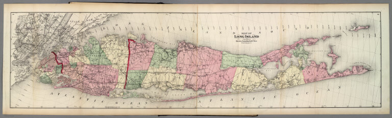
Map of Long Island. Published by Beers, Comstock & Cline, No. 36 Versey St., N.Y.
List No
0066.011
Note
Jurisdictions hand tinted in full color. Prime Meridian Washington D.C.
Author
Beers, F.W.
Full Title
The Flushing and North Side Railroad. Map of the Flushing and North Side Rail Road.
List No
0066.012
Note
Includes drawings of the Depot at Hinsdale, and Creedmoor, the National Rifle Range (building). Text on the Equipment and Construction of the (Rail) Road.
Author
Beers, F.W.
Full Title
Equipment and Construction of the (Rail) Road (continued). (Maps of:) Flatbush, East Astoria, Section East of Flatbush Village.
List No
0066.013
Note
Text on the Equipment and Construction of the railroad.
Author
Beers, F.W.
Full Title
The City of Brooklyn.
List No
0066.014
Author
Beers, F.W.
Full Title
Parkville P.O., Tn. of Flatbush. Windsor Terrace, Town of Flatbush. Bath, Town of New Utrecht. New Utrecht.
List No
0066.015
Author
Beers, F.W.
Full Title
Flatbush, Town of Flatbush, Kings County, L.I.
List No
0066.016
Author
Beers, F.W.
Full Title
Bayridge, Town of New Utrecht, Kings Co.
List No
0066.017
Author
Beers, F.W.
Full Title
Fort Hamilton, Town of New Utrecht, Kings Co., L.I.
List No
0066.018
Author
Beers, F.W.
Full Title
Portion of East New York. New Lots Tn., Kings Co., L.I.
List No
0066.019
Author
Beers, F.W.
Full Title
Gravesend, Kings Co., L.I.
List No
0066.020
|