|
Author
Surveyor General of India.
Full Title
(Covers to) The Punjab and Its Dependencies with Portions of the Northwest Provinces and Afghanistan. 1870. Compiled by the Surveyor General of India from the Latest Surveys. Second Edition. Published under the Direction of Colonel H.L. Thuiilier. Surveyor General's Office.
List No
7854.001
Note
Four large canvas backed sheets each dissected into 18 panels and mounted on linen for folding into a slipcase. Sheets 1 and 4 have one panel backed with blue marbled paper. Slipcase spine has text, "Punjab" in gilt.
Author
Surveyor General of India.
Full Title
Sheet 1. N.W. Punjab.
List No
7854.002
Author
Surveyor General of India.
Full Title
Sheet 2. N.E. Punjab.
List No
7854.003
Author
Surveyor General of India.
Full Title
Sheet 3. S.W. Punjab.
List No
7854.004
Author
Surveyor General of India.
Full Title
Sheet 4. S.E. Punjab.
List No
7854.005
Author
Surveyor General of India.
Full Title
(Composite map of) Sheets 1 - 4.
List No
7854.006
Author
[Beardshaw, John, Leonard, C.W.]
Full Title
(Covers to) Bacon's Chronological and Geographical Family Guide to The Holy Bible.
List No
15795.001
Author
[Beardshaw, John, Leonard, C.W.]
Full Title
Bacon's Chronological and Geographical Family Guide to The Holy Bible.
List No
15795.002
Author
Military Topographic Department of the Caucasus
Full Title
(Caucasus Mountains) Дорожная Карта Кавказскаго Края Составлена и Литографирована въ Военно-Топографическомъ Отдѣлѣ Кавказскаго Военнагоокруга [Road Map of the Caucasus Region Compiled and Lithographed by the Military Topographic Department of the Caucasus Military District]
List No
15250.000
Author
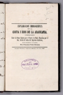
Gormaz, Francisco Vidal, 1837-1907
Full Title
(Title Page to) Esploracion hidrográfica de la costa i rios de la Araucanía, comprendidos entre la Punta Cauten por el norte i la Punta Chanchan por el sur, hecha de órden del Supremo Gobierno, por el Teniente 1o. de Marina, don Francisco Vidal Gormaz. Imprenta Nacional, Calle de la Moneda, Núm. 46. 1867.
List No
14329.003
Note
Title page to Esploracion hidrográfica de la costa i Ríos de la Araucanía. Title translates to: Hydrographic exploration of the coast and rivers of Araucanía. Includes imprint. With library stamp: Biblioteca de Francisco A. Lobos Santiago.
Author
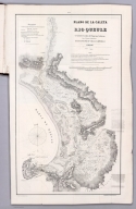
Gormaz, Francisco Vidal, 1837-1907
Full Title
Plano de la Caleta y Rio Queule levantado de orden del Supremo Gobierno por el Teniente 1o. de Marina dn. Francisco Vidal Gormaz. en 1866 i 1867. Lit. Cadot I Brandt, Santiago. Publicado por Decreto Supremo. No. 1.
List No
14329.004
Note
Nautical chart of the Caleta [Agua Fresca Bay] and Río Queule, Chile, from 1866 to 1867. Shows cities, roads, topography, vegetation, drainage, shorelines, shoals, islands and soundings. Relief illustrated with hachures. Includes a legend, coordinate points, two bar scales, a scale statement and a compass rose with north oriented toward top of sheet. Descriptive note beneath title. Text begins: La sonda trazada en el Río i sobre la barra, espresa pies ingleses i ha sido tomada en los momentos de baja marea [= The probe traced in the River and on the bar, expresed in English feet and taken at times of low tide]. Black and white lithograph. Chart is 62 x 35 cm, on fold-out sheet 71 x 44 cm. In first section of atlas, Esploracion hidrográfica de la costa i Ríos de la Araucanía.
Author
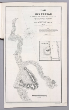
Gormaz, Francisco Vidal, 1837-1907
Full Title
Plano del Rio Queule que comprende desde el punto a. del plano No. 1. hasta el punto donde fue esplorado. Levantado de orden del Supremo Gobierno por el Teniente 1o. de Marina dn. Francisco Vidal Gormaz. en 1866 i 1867. Lit. Cadot I Brandt, Santiago. Publicado por Decreto Supremo. No. 2.
List No
14329.005
Note
Nautical chart of the Río Queule, Chile, from 1866 to 1867. Shows cities, roads, topography, vegetation, drainage, shoreline and soundings. Relief illustrated with hachures. Includes coordinate points, two bar scales and a scale statement, as well arrows indicating the direction of water flow and a compass rose with north oriented toward top of sheet. Descriptive note beneath title. Text begins: El Río Voroa, afluente principal del Queule, es remanso, profundo i navegable por embarcaciones menores en toda la estencion que ha sido esplorado [= The Voroa River, the main tributary of the Queule, is a backwater, deep and navigable by smaller vessels throughout the estuary that has been explored.]. With inset chart: Los Boldos. Black and white lithograph. Chart is 64 x 37 cm, on fold-out sheet 71 x 44 cm. In first section of atlas, Esploracion hidrográfica de la costa i Ríos de la Araucanía.
Author
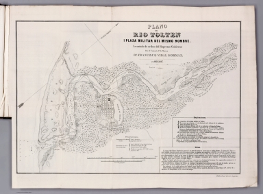
Gormaz, Francisco Vidal, 1837-1907
Full Title
Plano del Rio Tolten i plaza militar del mismo nombre. Levantado de orden del Supremo Gobierno por el Teniente 1o. de Marina dn. Francisco Vidal Gormaz. en 1866 i 1867. Publicado por Decreto Supremo.
List No
14329.006
Note
Nautical chart of the Río Tolten [Toltén River] and the military plaza of the same name, Chile, from 1866 to 1867. Shows cities, roads, topography, vegetation, drainage, shorelines, shoals, islands, anchorage and soundings. Relief illustrated with hachures. Includes a legend, coordinate points, two bar scales and a scale statement, as well arrows indicating the direction of water flow and a compass rose with north oriented toward top right of sheet. Descriptive note in bottom right corner. Text begins: La marea del Océano hincha las aguas del Río pero sin tornar el curso de éstas hácia adentro [= The tide of the ocean swells the waters of the river but without turning the course of these inwards]. Black and white lithograph. Chart is 33 x 49 cm, on fold-out sheet 40 x 54 cm. In first section of atlas, Esploracion hidrográfica de la costa i Ríos de la Araucanía.
Author
[Gormaz, Francisco Vidal, 1837-1907, Molinas, Francisco Javier, Castillo, Luis A.]
Full Title
Plano del Rio Cruces i sus afluentes, levantado de órden del Smo. Gno. durante los meses de Noviembre i Diciembre de 1867 i Enero, Febrero i Marzo de 1868, por La Comision Esploradora del Rio Valdivia, compuesta del Tte. 1o. Fco. Vidal Gormaz, Jefe de ella, i de los Ttes. 2os. Fco. Javier Molinas i Luis A. Castillo. Lita. Cadot I Brandt, Santiago.
List No
14329.007
Note
Nautical chart of the Río Cruces [Cruces River] and its tributaries, Chile, during November and December, 1867, as well as January, February and March, 1868. Shows cities, roads, vegetation, drainage, shorelines, shoals and islands. Includes latitudinal and longitudinal lines, two bar scales and a scale statement, as well a compass rose with north oriented toward top of sheet. Descriptive note beneath title. Text begins: Las lineas fuertes indican la parte esplorada por la Comision i las lineas auxiliares ó cortadas la prolongacion aparente de los Ríos [= The strong lines indicate the part explored by the Commission and the auxiliary or cut lines the apparent prolongation of the rivers]. Black and white lithograph. Chart is 37 x 48 cm, on fold-out sheet 49 x 52 cm. In first section of atlas, Esploracion hidrográfica de la costa i Ríos de la Araucanía.
Author
Gormaz, Francisco Vidal, 1837-1907
Full Title
(Section Title Page to) Continuacion de los Trabajos de Esploracion del Rio Valdivia i sus afluentes por el Capitan Graduado de Corbeta Francisco Vidal Gormaz. Santiago de Chile. Imprenta Nacional, Calle de la Moneda, No. 46. Julio de 1869.
List No
14329.008
Note
Section title page to the second section of Esploracion hidrográfica de la costa i Ríos de la Araucanía. Title translates to: Continuation of the Exploration Works of the Valdivia River and its tributaries. Includes imprint.
Author
Gormaz, Francisco Vidal, 1837-1907
Full Title
Secciones Trasversales de la Caja del Rio Calle-Calle : Fig. 1. Seccion en Puconu -- Fig. 2. Seccion frente al Rio Malihue -- Fig. 3. Seccion frente a la Mn. de Quinchilca. Lama. I.
List No
14329.009
Note
Three cross section views of the Río Calle-Calle [Calle-Calle River], Chile. Three different segments of the river, each with depth measurements. Descriptive note in bottom margin. Text: El punto A señala la caja que ocupan las aguas del rio [= Point A indicates the rea that the river waters occupy]. Black and white lithograph. Together, cross sections are 19 x 11 cm, on sheet 24 x 15 cm. In second section of atlas, Continuacion de los Trabajos de Esploracion del Rio Valdivia i sus afluentes.
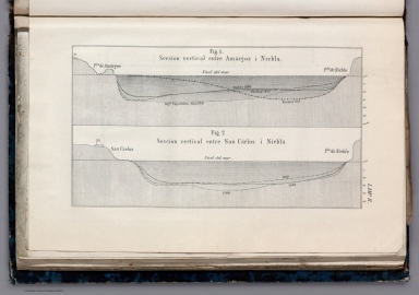
Author
Gormaz, Francisco Vidal, 1837-1907
Full Title
Fig. 1. Seccion vertical entre Amárgos i Niebla -- Fig. 2. Seccion vertical entre San Cárlos i Niebla. Lama. II.
List No
14329.010
Note
Two cross section views showing the areas between Amárgos and Niebla, as well as San Cárlos and Niebla, Chile. Different explorers and dates listed in association with depth measurements. Black and white lithograph. Together, cross sections are 10 x 18 cm, on fold-out sheet 15 x 24 cm. In second section of atlas, Continuacion de los Trabajos de Esploracion del Rio Valdivia i sus afluentes.
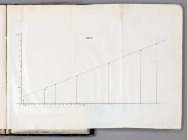
Author
Gormaz, Francisco Vidal, 1837-1907
Full Title
Lama. B.
List No
14329.011
Note
Statistical chart showing data on an incline from October 10 to November 30, [1869]. Black and white lithograph. Chart is 10 x 18 cm, on fold-out sheet 14 x 17 cm. In second section of atlas, Continuacion de los Trabajos de Esploracion del Rio Valdivia i sus afluentes.
Author
[Gormaz, Francisco Vidal, 1837-1907, Molinas, Francisco Javier, Castillo, Luis A.]
Full Title
Plano del Rio Calle-Calle i sus tributarios, levantado de órden del Supremo Gobierno durante los años de 67 a 69. Por La Comision Esploradora del Rio Valdivia, compuesta del Capan. de Cta. Grado. Fco. Vidal Gormaz, Jefe de ella, i de los Tenientes 2os. Fco. Javier Molinas i Luis A. Castillo. Lit. Cadot I Brandt, Santo.
List No
14329.012
Note
Nautical chart of the Río Calle-Calle [Calle-Calle River] and its tributaries, Chile, from the years 1867 to 1869. Shows cities, roads, topography, vegetation, drainage, shorelines, shoals and islands. Relief illustrated with hachures. Includes latitudinal and longitudinal lines, a scale statement and a compass rose with north oriented toward top of sheet. Descriptive note beneath title. Text begins: En este plano hemos correjido los errores de lonjitud de que estaba asectado el Rio Crúces [= In this plan we have corrected the errors in the length of the Rio Crúces, according to the publication of last year]. Black and white lithograph. Chart is 49 x 68 cm, on fold-out sheet 57 x 73 cm. In second section of atlas, Continuacion de los Trabajos de Esploracion del Rio Valdivia i sus afluentes.
Author
Gormaz, Francisco Vidal, 1837-1907
Full Title
(Section Title Page to) Reconocimientos de la costa comprendida entre la rada de Los Vilos i el Rio Chopa, i del Rio Valdiva i costa comprendida entre el Morro Bonifacio i el Rio Maullin, verificados de órden del supremo gobierno por Francisco Vidal Gormaz, Capitan graduado de Corbeta. Santiago de Chile. Imprenta Nacional, Calle de la Moneda, No. 46. 1870.
List No
14329.013
Note
Section title page to the third section of Esploracion hidrográfica de la costa i Ríos de la Araucanía. Title translates to: The coast between Los Vilos and the Choapa River, and the Valdivia River and the coast between the Morro Bonifacio [headland located in Los Lagos] and the Maullín River. Includes imprint.
Author
Gormaz, Francisco Vidal, 1837-1907
Full Title
Plano de la costa de Chile comprendida entre la punta Ventana por el norte i la ensenada del Negro por el sur. Levantado de órden del Supremo Gobierno én Octubre de 1869. Por el Can. de Corbeta Gdo. D. Fco. Vidal Gormáz, i los Oficiales de la Corbeta Chacabuco.
List No
14329.014
Note
Nautical chart of the Chilean coast, between Punta Ventana [= "Window Point"] in the north and Ensenada del Negro [= "Black Cove"] in the south, in October, 1869. Shows cities, roads, topography, vegetation, drainage, shorelines, shoals, islands and soundings. Relief illustrated with hachures. Includes latitudinal and longitudinal lines, statements of scale and magnetic declination, as well as a compass rose with north oriented toward right of sheet. Descriptive note beneath title. Text begins: La sonda está espresada en brazas inglesas [= The probe is expressed in English fathoms]. With three inset views: [Roca Corales ; Rada los Vilos al E. ; Isla Huevos] -- [Punta Ventana ; Punta Loberia al E.] -- [Punta Ventanas ; Caleta de Huenteláugquen al E.] Black and white lithograph. Chart is 42 x 69 cm, on fold-out sheet 55 x 73 cm. In third section of atlas, Reconocimientos de la costa comprendida entre la rada de Los Vilos i el Rio Chopa ...
Author
Gormaz, Francisco Vidal, 1837-1907
Full Title
Plano del Rio Valdivia i sus tributarios australes. Lit. Cadot I Brandt, Santiago.
List No
14329.015
Note
Nautical chart of the Río Valdivia [Valdivia River] and its southern tributaries, Chile, in 1869. Shows cities, roads, drainage, shorelines, shoals and islands. Includes latitudinal and longitudinal lines, a scale statement and a compass rose with north oriented toward top of sheet. Black and white lithograph. Chart is 26 x 28 cm, on fold-out sheet 32 x 31 cm. In third section of atlas, Reconocimientos de la costa comprendida entre la rada de Los Vilos i el Rio Chopa ...
Author
Gormaz, Francisco Vidal, 1837-1907
Full Title
Diagrama I.
List No
14329.016
Note
Diagram showing both circular and angular directions with arrows, including magnetic north, oriented toward top of sheet. Black and white lithograph. Diagram is 19 x 10 cm, on sheet 23 x 16 cm. In third section of atlas, Reconocimientos de la costa comprendida entre la rada de Los Vilos i el Rio Chopa ...
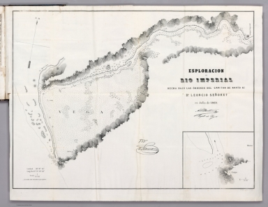
Author
[Gormaz, Francisco Vidal, 1837-1907, Señoret, Leoncio]
Full Title
Esploracion del Rio Imperial hecha bajo las órdenes del capitan de navío go. dn. Leoncio Señoret en Julio de 1869. Lit. Cadot I Brandt, Santiago.
List No
14329.017
Note
Nautical chart of the Río Imperial [Imperial River], Chile, in July, 1869. Shows cities, roads, topography, drainage, shorelines, shoals, islands, soundings and anchorage. Relief illustrated with hachures. Includes coordinate points, a scale statement and a compass rose with north oriented toward top of sheet. Descriptive note beneath title. Text: Las sondas están marcadas en pies ingleses [= Probes are marked in English feet]. With inset chart: [C. Cholgui]. Black and white lithograph. Chart is 46 x 63 cm, on fold-out sheet 51 x 66 cm. In third section of atlas, Reconocimientos de la costa comprendida entre la rada de Los Vilos i el Rio Chopa ...
Author
[Gormaz, Francisco Vidal, 1837-1907, Goñi, José Anacleto, Molinas, Francisco Javier, Uribe, Luis, Lynch, Luis A.]
Full Title
Rapa Nuí ó Isla de Pascua. Levantado de órden del Capitan de Navio D. José Anacleto Goñi. Comandante de la Corbeta chilena "O'Higgins" por los tenientes 2os. D. Javier Molinas, D. Luis Uribe, Ga. Ma. Ex. D. Luis A. Lynch i los cadetes SS. Cueto, Goñi, Lynch, Aguayo i Serrano Montaner. Corbeta O'Higgins. Enero de 1870. Lit. Cadot. Brandt, Santiago.
List No
14329.018
Note
Nautical chart of Isla de Pascua [Easter Island], Chile, in January, 1870. Shows cities, roads, topography, drainage, shorelines, shoals, islands, soundings and anchorage. Relief illustrated with hachures. Includes coordinate points, a bar scale, arrows indicating the direction of water flow and a compass rose with north oriented toward top of sheet. Black and white lithograph. Chart is 38 x 53 cm, on fold-out sheet 46 x 57 cm. In third section of atlas, Reconocimientos de la costa comprendida entre la rada de Los Vilos i el Rio Chopa ...
Author
[Gormaz, Francisco Vidal, 1837-1907, Goñi, José Anacleto, Molinas, Francisco Javier, Uribe, Luis, Lynch, Luis A.]
Full Title
Anakena -- Hanga Roa ó Bahia Cook. Levantado de órden del Capitan de Navio D. José Anacleto Goñi. Comandante de la Corbeta Chilena O'Higgins por los tenientes 2os. D. Javier Molinas, D. Luis Uribe, Ga. Ma. Ex. D. Luis A. Lynch i los cadetes Goñi, Aguayo, Lynch, Cueto i Serrano. Enero de 1870. Lit. Cadot i Brandt, Santiago.
List No
14329.019
Note
Two nautical charts of Anakena Cove [Easter Island] and Bahía Cook [Cook Bay] Chile, in January, 1870. Charts show cities, roads, topography, vegetation, drainage, shorelines, shoals, islands and soundings. Relief illustrated with hachures. Includes coordinate points bar scales and a compass roses with north oriented toward top right and top left of sheet, respectively. Descriptive note beneath title. Text begins: La Bahia Cook denominada por los indigenas Hanga Roa ofrece un regular abrigo con vientos del N. E. al S. E. siendo el mejor fondeadero el designado con la letra B [= The Cook Bay called by the indigenous Hanga Roa offers a regular shelter with winds from N.E. to S.E., the best anchorage being designated with the letter B]. Black and white lithograph. Together, charts are 45 x 63 cm, on fold-out sheet 53 x 66 cm. In third section of atlas, Reconocimientos de la costa comprendida entre la rada de Los Vilos i el Rio Chopa ...
Author
[Gormaz, Francisco Vidal, 1837-1907, Simpson, Enrique]
Full Title
Esploracion de la costa occidental de la Patagonia. Plano levantado por los Oficiales de la corbeta Chacabuco. al mando del capitan de fragato graduado dn. Enrique Simpson. durante los meses de Marzo in Abril de 1870. Lit. A. Vega ...
List No
14329.020
Note
Nautical chart of the exploration of the Patagonian west coast, Argentina and Chile, in March and April, 1870. Shows cities, roads, topography, vegetation, drainage, shorelines, shoals, islands and soundings. Relief illustrated with hachures. Includes latitudinal and longitudinal lines, a scale statement and a compass rose with north oriented toward top of sheet. Black and white lithograph. With three inset charts: Puerto Laguna -- Puerto Perez -- Puerto Chacabuco. Chart is 34 x 56 cm, on fold-out sheet 44 x 61 cm. In third section of atlas, Reconocimientos de la costa comprendida entre la rada de Los Vilos i el Rio Chopa ...
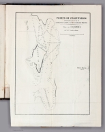
Author
[Gormaz, Francisco Vidal, 1837-1907, Gaona, Miguel, Prieto, Cárlos]
Full Title
Puerto de Constitucion. Levantado por el Tte. 2o. D. Miguel Gaona i Ga. Ma . D. Cárlos Prieto. Lit. Cadot i Brandt, Santiago.
List No
14329.021
Note
Nautical chart of port of Constitucion, Chile, in 1870. Shows cities, roads, topography, vegetation, drainage, shorelines, shoals, islands, soundings and anchorage. Relief illustrated with hachures. Includes coordinate points, a bar scale and a compass rose with north oriented toward top of sheet. Black and white lithograph. Chart is 26 x 20 cm, on fold-out sheet 32 x 24 cm. In third section of atlas, Reconocimientos de la costa comprendida entre la rada de Los Vilos i el Rio Chopa ...
Author
[Gormaz, Francisco Vidal, 1837-1907, Gaona, Miguel, Prieto, Cárlos]
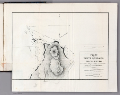
Full Title
Plano de Punta Angamos y Roca Abtoa. Levdo. en Enro. de 1870 por el Tte. 20. D. Miguel Gaona i el Ga. Ma . D. Cárlos Prieto. Lit. Cadot i Brandt.
List No
14329.022
Note
Nautical chart of the peninsula Punta Angamos and the rock Roca Abtao in Antofagasta, Chile, in January, 1870. Shows topography, drainage, shorelines, islands, soundings and anchorage. Relief illustrated with hachures. Includes coordinate points, a bar scale and a compass rose with north oriented toward top of sheet. Black and white lithograph. Chart is 24 x 24 cm, on fold-out sheet 34 x 32 cm. In third section of atlas, Reconocimientos de la costa comprendida entre la rada de Los Vilos i el Rio Chopa ...
Author
Colton, G.W. & C.B.
Full Title
Colton's Railroad Map (Intermediate Size) Of The United States. Reduced Fom "Colton's Railroad & Commercial Map of the United States." Published By G.W. And C.B. Colton & Co. 172 William St. New York. Entered .. 1870 by G.W. & C.B. Colton & Co. ... New York. (inset) Plan Of The Western Portion of the United States.
List No
2689.000
Author
Wallace, John.
Full Title
Map Of The County Of San Joaquin. Compiled From The United States Surveys, the Maps and Records of the County Surveyor and County Assessor. 1870. By John Wallace, Co., Surveyor ... Approved And Declared to be the Official Map of San Joaquin County by the Supervisors July 6th 1870. A.L. Bancroft & Co. Steam Lithographic Printing House 721 Market St., S.F.
List No
2296.000
Author
White, Charles A.
Full Title
(Covers to)) Map Of Washington Territory West of the Cascade Mountains. Compiled from the Government Surveys by Chas. A. White, C.E. 1870. Engraved, Printed, Manufactured And Published By G.W. & C.B. Colton & Co. No. 172 William St. New York.
List No
2462.001
Author
White, Charles A.
Full Title
(Sheet 1) Map Of Washington Territory West of the Cascade Mountains. Compiled from the Government Surveys by Chas. A. White, C.E. 1870. Engraved, Printed, Manufactured And Published By G.W. & C.B. Colton & Co. No. 172 William St. New York.
List No
2462.002
Author
White, Charles A.
Full Title
(Sheet 2) Map Of Washington Territory West of the Cascade Mountains. Compiled from the Government Surveys by Chas. A. White, C.E. 1870. Engraved, Printed, Manufactured And Published By G.W. & C.B. Colton & Co. No. 172 William St. New York.
List No
2462.003
Author
White, Charles A.
Full Title
(Sheet 3) Map Of Washington Territory West of the Cascade Mountains. Compiled from the Government Surveys by Chas. A. White, C.E. 1870. Engraved, Printed, Manufactured And Published By G.W. & C.B. Colton & Co. No. 172 William St. New York.
List No
2462.004
Author
White, Charles A.
Full Title
(Sheet 4) Map Of Washington Territory West of the Cascade Mountains. Compiled from the Government Surveys by Chas. A. White, C.E. 1870. Engraved, Printed, Manufactured And Published By G.W. & C.B. Colton & Co. No. 172 William St. New York.
List No
2462.005
Author
White, Charles A.
Full Title
(Composite map to) (Sheets 1-4) Map Of Washington Territory West of the Cascade Mountains. Compiled from the Government Surveys by Chas. A. White, C.E. 1870. Engraved, Printed, Manufactured And Published By G.W. & C.B. Colton & Co. No. 172 William St. New York.
List No
2462.006
Author
Viele, Egbert L. (Egbert Ludovicus), 1825-1902
Full Title
The proposed arcade railway under Broadway (view near Wall St.).
List No
3892.002
Note
Black and white view: The proposed arcade railway under Broadway (view near Wall St.).
Author
Viele, Egbert L. (Egbert Ludovicus), 1825-1902
Full Title
(Title Page to) The Arcade Under-Ground Railway. Report of Egbert L. Viele, "Engineer in Chief." S. B. B. Nowlan, Constructing Engineer.
List No
3892.003
Note
Title page to The Arcade Under-Ground Railway, report of Egbert L. Viele. Includes an extended statement of responsibility crediting consulting engineers. With handwritten annotations, in pencil: 1870 - see Chase Viele, p. 39. Adjacent page has black and white view: The proposed arcade railway under Broadway (view near Wall St.).
Author
Viele, Egbert L. (Egbert Ludovicus), 1825-1902
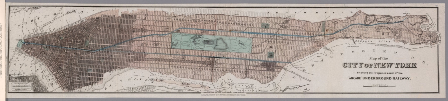
Full Title
Map of the city of New York showing the proposed route of the "Arcade" Underground Railway. Prepared at Coltons Geographical Establishment. G. W. & C. B. Colton & Co. 172 William Street, New York.
List No
3892.006
Note
Hand-colored, engraved map of Manhattan illustrating the proposed route of the "Arcade Underground Railway". Also shows streets, bridges, squares, forts, prisons, cemeteries, quarries, topography, reservoirs, drainage, marshlands, shoreline, piers, ferry routes with distances, islands and soundings. Relief shown with hachures. Features detailed representation of Central Park, for which the author of this report was also the Chief Engineer and Designer. Includes a bar scale. With advertisement at lower left of sheet: Maps of every description to accompany reports, prospectuses etc. Drawn, engraved, printed & colored at Coltons Geographical Establishment, No 172 William St. New York. Map is 22 x 107 cm, on sheet 25 x 110 cm, folded to 25 x 15 cm.
Author
Bertillon, Louis-Adolphe, 1821-1883
Full Title
Mortalité comparée à chaque groupe d'âge des diverses nations de l'Europe pendant une période de plusieurs années normales comprises entre 1850 à 1870 : Tableau LIII et LIV : Mortalité de 0 à 1 an -- Mortalité de 1 à 5 ans -- Mortalité de 5 à 15 ans -- Mortalité de 15 à 30 ans -- Mortalité de 30 à 60 ans -- Mortalité au-delà de 60 ans.
List No
14345.033
Note
Comparative statistical chart of Europe. Shows mortality rates according to age, from birth to sixty years, during the period of 1850-1870. Includes explanatory notes and descriptive text. Black and white lithograph. Chart is 44 x 53 cm, on double-sheet 45 x 57 cm. Appears in Section B, 3rd Series.
Author
[France. Ministère des travaux publics. Administration des routes, France. Direction des cartes, plans et archives et de la statistique graphique, École nationale des ponts et chaussées (France)]
Full Title
Séville. (1870). 5e Série. Pl. VI. Ministère des Travaux Publics. Ecole des Ponts et Chaussées. Lith. A. Simon, 13, R. du Val-de-Grâce. Paris.
List No
14306.123
Note
Map showing the port of Seville, Spain, in 1870. Features vegetation, railways, streets, bridges, parks, drainage, docks and soundings, with depths given in meters. Includes a bar scale and compass rose, with north oriented toward top of sheet. Descriptive text throughout. Lithograph in black, white and blue. With inset map: [Seville and vicinity]. Together, maps are 27 x 21 cm, on sheet 33 x 25 cm. Appears in Cinquième livraison.
Author
Anonymous
Full Title
Labirint. Geograficheskaya igra (The Maze. Geographical game)
List No
10486.000
Note
Published in rural Russia, in the Tver region, village Lushkino The lithographed game is printed in the tiny village in Tver region in central Russia. It includes the coat of arms of 57 major cities of Russian Empire, all numbered. They are located on the leaf in accordance with their geographical position: the most northern is Arkhangelsk and Erevan is the one furthest in the south. Remarkable survival of the time. (Pavel Chepyzhov, 2019)
Author
[Hayden, Ferdinand Vandeveer, 1829-1887, Russell, Andrew Joseph, 1830-1902]
Full Title
Moore's Lake - head of Bear River, Uintah Mountains. (to accompany) Sun pictures of Rocky Mountain scenery ... by F. V. Hayden, ... New York : Julius Bien, 1870.
List No
13389.003
Note
Black and white view of Moore's Lake at the head of the Bear River in the Uinta Mountains in Utah.
Author
[Hayden, Ferdinand Vandeveer, 1829-1887, Russell, Andrew Joseph, 1830-1902]
Full Title
(Title Page to) Sun pictures of Rocky Mountain scenery: with a description of the geographical and geological features, and some account of the resources of the Great West : containing thirty photographic views along the line of the Pacific Rail Road, from Omaha to Sacramento, by F. V. Hayden, M. D., ... New York : Julius Bien, 1870. (verso) Printed by the New York Lithographing, Engraving and Printing Company.
List No
13389.004
Author
[Hayden, Ferdinand Vandeveer, 1829-1887, Russell, Andrew Joseph, 1830-1902]
Full Title
Skull Rock - (granite) Sherman Station, Laramie Mountains. (to accompany) Sun pictures of Rocky Mountain scenery ... by F. V. Hayden, ... New York : Julius Bien, 1870.
List No
13389.007
Note
Black and white view of Skull Rock. Shows rock formation.
Author
[Hayden, Ferdinand Vandeveer, 1829-1887, Russell, Andrew Joseph, 1830-1902]
Full Title
Dial Rock, Red Buttes, Laramie Plains. (to accompany) Sun pictures of Rocky Mountain scenery ... by F. V. Hayden, ... New York : Julius Bien, 1870.
List No
13389.009
Note
Black and white view of Dial Rock. Shows rock formation.
Author
[Hayden, Ferdinand Vandeveer, 1829-1887, Russell, Andrew Joseph, 1830-1902]
Full Title
Citadel Rock : Green River Valley. (to accompany) Sun pictures of Rocky Mountain scenery ... by F. V. Hayden, ... New York : Julius Bien, 1870.
List No
13389.015
Note
Black and white view, shows construction of a railroad bridge in the Green River Valley, Wyoming.
Author
[Hayden, Ferdinand Vandeveer, 1829-1887, Russell, Andrew Joseph, 1830-1902]
Full Title
Sentinel Rock - Echo Canon. (to accompany) Sun pictures of Rocky Mountain scenery ... by F. V. Hayden, ... New York : Julius Bien, 1870.
List No
13389.020
Note
Black and white view, shows rock formations in Echo Canon, Utah.
Author
[Hayden, Ferdinand Vandeveer, 1829-1887, Russell, Andrew Joseph, 1830-1902]
Full Title
Hanging Rock : Echo Canon. (to accompany) Sun pictures of Rocky Mountain scenery ... by F. V. Hayden, ... New York : Julius Bien, 1870.
List No
13389.021
Note
Black and white view, shows rock formations and settlements in Echo Canon, Utah.
|


![(Caucasus Mountains) Дорожная Карта Кавказскаго Края Составлена и Литографирована въ Военно-Топографическомъ Отдѣлѣ Кавказскаго Военнагоокруга [Road Map of the Caucasus Region Compiled and Lithographed by the Military Topographic Department of the Caucasus Military District]](https://www.davidrumsey.com/rumsey/Size2/RUMSEY~8~1/199/15250000.jpg)