|
Author
[Lewis, William J., State Harbor Commissioners (California)]
Full Title
Map of the Waterfront of San Francisco from the South Line of Chestnut Street to The North Line of Harrison Street.
List No
15814.001
Author
[Lewis, William J., State Harbor Commissioners (California)]
Full Title
(Title page to) Map of the Waterfront of San Francisco from the South Line of Chestnut Street to The North Line of Harrison Street.
List No
15814.002
Author
Gormaz, Francisco Vidal, 1837-1907
Full Title
(Section Title Page to) Continuacion de los Trabajos de Esploracion del Rio Valdivia i sus afluentes por el Capitan Graduado de Corbeta Francisco Vidal Gormaz. Santiago de Chile. Imprenta Nacional, Calle de la Moneda, No. 46. Julio de 1869.
List No
14329.008
Note
Section title page to the second section of Esploracion hidrográfica de la costa i Ríos de la Araucanía. Title translates to: Continuation of the Exploration Works of the Valdivia River and its tributaries. Includes imprint.
Author
Gormaz, Francisco Vidal, 1837-1907
Full Title
Secciones Trasversales de la Caja del Rio Calle-Calle : Fig. 1. Seccion en Puconu -- Fig. 2. Seccion frente al Rio Malihue -- Fig. 3. Seccion frente a la Mn. de Quinchilca. Lama. I.
List No
14329.009
Note
Three cross section views of the Río Calle-Calle [Calle-Calle River], Chile. Three different segments of the river, each with depth measurements. Descriptive note in bottom margin. Text: El punto A señala la caja que ocupan las aguas del rio [= Point A indicates the rea that the river waters occupy]. Black and white lithograph. Together, cross sections are 19 x 11 cm, on sheet 24 x 15 cm. In second section of atlas, Continuacion de los Trabajos de Esploracion del Rio Valdivia i sus afluentes.
Author
Gormaz, Francisco Vidal, 1837-1907
Full Title
Fig. 1. Seccion vertical entre Amárgos i Niebla -- Fig. 2. Seccion vertical entre San Cárlos i Niebla. Lama. II.
List No
14329.010
Note
Two cross section views showing the areas between Amárgos and Niebla, as well as San Cárlos and Niebla, Chile. Different explorers and dates listed in association with depth measurements. Black and white lithograph. Together, cross sections are 10 x 18 cm, on fold-out sheet 15 x 24 cm. In second section of atlas, Continuacion de los Trabajos de Esploracion del Rio Valdivia i sus afluentes.
Author
Gormaz, Francisco Vidal, 1837-1907
Full Title
Lama. B.
List No
14329.011
Note
Statistical chart showing data on an incline from October 10 to November 30, [1869]. Black and white lithograph. Chart is 10 x 18 cm, on fold-out sheet 14 x 17 cm. In second section of atlas, Continuacion de los Trabajos de Esploracion del Rio Valdivia i sus afluentes.
Author
[Gormaz, Francisco Vidal, 1837-1907, Molinas, Francisco Javier, Castillo, Luis A.]
Full Title
Plano del Rio Calle-Calle i sus tributarios, levantado de órden del Supremo Gobierno durante los años de 67 a 69. Por La Comision Esploradora del Rio Valdivia, compuesta del Capan. de Cta. Grado. Fco. Vidal Gormaz, Jefe de ella, i de los Tenientes 2os. Fco. Javier Molinas i Luis A. Castillo. Lit. Cadot I Brandt, Santo.
List No
14329.012
Note
Nautical chart of the Río Calle-Calle [Calle-Calle River] and its tributaries, Chile, from the years 1867 to 1869. Shows cities, roads, topography, vegetation, drainage, shorelines, shoals and islands. Relief illustrated with hachures. Includes latitudinal and longitudinal lines, a scale statement and a compass rose with north oriented toward top of sheet. Descriptive note beneath title. Text begins: En este plano hemos correjido los errores de lonjitud de que estaba asectado el Rio Crúces [= In this plan we have corrected the errors in the length of the Rio Crúces, according to the publication of last year]. Black and white lithograph. Chart is 49 x 68 cm, on fold-out sheet 57 x 73 cm. In second section of atlas, Continuacion de los Trabajos de Esploracion del Rio Valdivia i sus afluentes.
Author
Gormaz, Francisco Vidal, 1837-1907
Full Title
Plano de la costa de Chile comprendida entre la punta Ventana por el norte i la ensenada del Negro por el sur. Levantado de órden del Supremo Gobierno én Octubre de 1869. Por el Can. de Corbeta Gdo. D. Fco. Vidal Gormáz, i los Oficiales de la Corbeta Chacabuco.
List No
14329.014
Note
Nautical chart of the Chilean coast, between Punta Ventana [= "Window Point"] in the north and Ensenada del Negro [= "Black Cove"] in the south, in October, 1869. Shows cities, roads, topography, vegetation, drainage, shorelines, shoals, islands and soundings. Relief illustrated with hachures. Includes latitudinal and longitudinal lines, statements of scale and magnetic declination, as well as a compass rose with north oriented toward right of sheet. Descriptive note beneath title. Text begins: La sonda está espresada en brazas inglesas [= The probe is expressed in English fathoms]. With three inset views: [Roca Corales ; Rada los Vilos al E. ; Isla Huevos] -- [Punta Ventana ; Punta Loberia al E.] -- [Punta Ventanas ; Caleta de Huenteláugquen al E.] Black and white lithograph. Chart is 42 x 69 cm, on fold-out sheet 55 x 73 cm. In third section of atlas, Reconocimientos de la costa comprendida entre la rada de Los Vilos i el Rio Chopa ...
Author
Gormaz, Francisco Vidal, 1837-1907
Full Title
Plano del Rio Valdivia i sus tributarios australes. Lit. Cadot I Brandt, Santiago.
List No
14329.015
Note
Nautical chart of the Río Valdivia [Valdivia River] and its southern tributaries, Chile, in 1869. Shows cities, roads, drainage, shorelines, shoals and islands. Includes latitudinal and longitudinal lines, a scale statement and a compass rose with north oriented toward top of sheet. Black and white lithograph. Chart is 26 x 28 cm, on fold-out sheet 32 x 31 cm. In third section of atlas, Reconocimientos de la costa comprendida entre la rada de Los Vilos i el Rio Chopa ...
Author
Gormaz, Francisco Vidal, 1837-1907
Full Title
Diagrama I.
List No
14329.016
Note
Diagram showing both circular and angular directions with arrows, including magnetic north, oriented toward top of sheet. Black and white lithograph. Diagram is 19 x 10 cm, on sheet 23 x 16 cm. In third section of atlas, Reconocimientos de la costa comprendida entre la rada de Los Vilos i el Rio Chopa ...
Author
[Gormaz, Francisco Vidal, 1837-1907, Señoret, Leoncio]
Full Title
Esploracion del Rio Imperial hecha bajo las órdenes del capitan de navío go. dn. Leoncio Señoret en Julio de 1869. Lit. Cadot I Brandt, Santiago.
List No
14329.017
Note
Nautical chart of the Río Imperial [Imperial River], Chile, in July, 1869. Shows cities, roads, topography, drainage, shorelines, shoals, islands, soundings and anchorage. Relief illustrated with hachures. Includes coordinate points, a scale statement and a compass rose with north oriented toward top of sheet. Descriptive note beneath title. Text: Las sondas están marcadas en pies ingleses [= Probes are marked in English feet]. With inset chart: [C. Cholgui]. Black and white lithograph. Chart is 46 x 63 cm, on fold-out sheet 51 x 66 cm. In third section of atlas, Reconocimientos de la costa comprendida entre la rada de Los Vilos i el Rio Chopa ...
Author
Palmer, William. J.
Full Title
Map Of The Route Of The Southern Continental R.R. With Connections From Kansas City Mo. Ft. Smith Ark. And Shreveport La. Giving a general View of the Recent Surveys of the Kansas Pacific Railway Co, across the Continent Made in 1867 & 1868 under the direction of Gen. Wm. J. Palmer. On the routes of the 32nd and 35th Parallels. J.F Gedney Lith, Washington, D.C.
List No
3725.000
Note
Removed from Palmer's 1869 "Report of Surveys...for a route extending the Kansas Pacific Railway to the Pacific Ocean." Palmer used an exact copy Keeler's 1868 reduced scale edition of his National Map of the United States without credit in this first issue although Palmer's map adds much material along the line of the proposed southern continental route, especially in the Grand Canyon; in fact, this map is best known as the first map to use the name "Grand Canyon" of the Colorado. The Kansas Pacific had dreams of extending their line to California, as shown on this map, but it never happened. The map shows the routes of the Northern Pacific, the Union and Central Pacific, and the Southern Route. Ms color red and blue lines have been drawn on the various routes, adding an additional route from Centreville, Nevada, to Portland, Oregon (probably following Dodge's proposals - see his report). The main Kansas Pacific line has at least sixteen proposed branches! There is a later issue of this map that credits Keeler as a source (see our copy).
Author
Palmer, William. J.
Full Title
Map Of The Route Of The Southern Continental R.R. With Connections From Kansas City Mo. Ft. Smith Ark. And Shreveport La. Giving a general View of the Recent Surveys of the Kansas Pacific Railway Co, across the Continent Made in 1867 & 1968 under the direction of Gen. Wm. J. Palmer. On the routes of the 32nd and 35th Parallels together with compilations from Keeler's Official Map showing the Central and Northern Routes to the Pacific, and the intermediate topography. J.F Gedney Lith, Washington, D.C.
List No
4692.000
Note
This is a somewhat later issue of the Palmer map that adds a Keeler credit in the title, above the title adds the date June 1869 next to three railroad symbol explanations, and adds a table of "Distances by the Kansas Pacific Railway to Denver & Cheyenne thence by the Pacific Railroad to San Francisco," and eliminates the "explanations" in the lower right.
Author
[Dormoy, Émile, Administration des Mines]
Full Title
(Title Page to) Topographie souterraine du Bassin Houiller de Valenciennes par M. Émile Dormoy, Ingénieur au Corps Impérial des Mines : Cartes et plans. Paris, Imprimerie Impériale, MDCCCLXIX.
List No
14382.003
Note
Title page to Topographie souterraine du Bassin Houiller de Valenciennes. Includes imprint. Title translates to: Underground topography of the Valenciennes Coal Basin by Mr. Émile Dormoy, Engineer at the Imperial Corps of Mines : Maps and plans.
Author
[Dormoy, Émile, Administration des Mines]
Full Title
(Section Title Page to) Carte topographie souterraine du Bassin Houiller de Valenciennes réuni au bassin du Couchant de Mons dressée par M. Émile Dormoy, Ingénieur au Corps Impérial des Mines, 1867.
List No
14382.009
Note
Section title page to Topographie souterraine du Bassin Houiller de Valenciennes. Includes imprint. Title translates to: Underground topography map of the of Valenciennes Coal Basin, joined to the "Couchant de Mons".
Author
[Dormoy, Émile, Administration des Mines]
Full Title
(Composite map to) (Sheets 1-15) Tableau d'assemblage de la carte topographieque souterraine du Bassin Houiller de Valenciennes relié au couchant du Bassin de Mons, Dressée par M. Emile Dormoy, Ingénieur des Mines. Imprimerie Impériale.
List No
14382.028
Author
[Schièble, Erhard, 1821-1880, Lanée, E.]
Full Title
(Covers to) سويش بوغازى واطرافلريند خريطه سى [Süveyş boğazı ve etraflarinde harita-sı / Map of the Suez Canal and its Surroundings]
List No
10599.001
Author
[Schièble, Erhard, 1821-1880, Lanée, E.]
Full Title
سويش بوغازى واطرافلريند خريطه سى [Süveyş boğazı ve etraflarinde harita-sı / Map of the Suez Canal and its Surroundings]
List No
10599.002
Author
Scheda, Josef, Ritter von, 1815-1888
Full Title
(Covers to) General-Karte der Europaeischen Turkei und des Konigreiches Griechenland. Herausgegeben von Josef Ritter v. Scheda. K.K. Oesterr Oberst. (with) Plan von Constantinopel.
List No
11517.001
Note
1 color map of Ottoman Empire in Europe and Kingdom of Greece on 13 sheets, dissected and mounted on linen; 193 x 151, sheets 53 x 53 or smaller, folded into half leather black slipcase with title "General-Karte der Europ Turkei und des Konigr Griechenland" in gilt. Relief shown by shading. Includes index map on additional sheet and inset "Plan von Constantinopel" on sheet XI. Map shows political and administrative divisions, cities, towns, roads, rivers, lakes and landmarks. Includes legend, abbreviation table and statistical table.
Author
Scheda, Josef, Ritter von, 1815-1888
Full Title
(Index Page to) Ubersichtsblatt fur die Zusammenstellung der Blatter der General-Karte der Europaeischen Turkei und des Konigreiches Griechenland. Herausgegeben von Josef Ritter v. Scheda. K.K. Oesterr Oberst. (with) Plan von Constantinopel.
List No
11517.002
Note
1 color map of Ottoman Empire in Europe and Kingdom of Greece on 13 sheets, dissected and mounted on linen; 193 x 151, sheets 53 x 53 or smaller, folded into half leather black slipcase with title "General-Karte der Europ Turkei und des Konigr Griechenland" in gilt. Relief shown by shading. Includes index map on additional sheet and inset "Plan von Constantinopel" on sheet XI. Map shows political and administrative divisions, cities, towns, roads, rivers, lakes and landmarks. Includes legend, abbreviation table and statistical table.
Author
Scheda, Josef, Ritter von, 1815-1888
Full Title
(Title Page) General-Karte der Europaeischen Turkei und des Konigreiches Griechenland. Herausgegeben von Josef Ritter v. Scheda. K.K. Oesterr Oberst. (with) Plan von Constantinopel.
List No
11517.004
Note
1 color map of Ottoman Empire in Europe and Kingdom of Greece on 13 sheets, dissected and mounted on linen; 193 x 151, sheets 53 x 53 or smaller, folded into half leather black slipcase with title "General-Karte der Europ Turkei und des Konigr Griechenland" in gilt. Relief shown by shading. Includes index map on additional sheet and inset "Plan von Constantinopel" on sheet XI. Map shows political and administrative divisions, cities, towns, roads, rivers, lakes and landmarks. Includes legend, abbreviation table and statistical table.
Author
Scheda, Josef, Ritter von, 1815-1888
Full Title
General-Karte der Europaeischen Turkei und des Konigreiches Griechenland. Herausgegeben von Josef Ritter v. Scheda. K.K. Oesterr Oberst. (with) Plan von Constantinopel.
List No
11517.024
Note
1 color map of Ottoman Empire in Europe and Kingdom of Greece on 13 sheets, dissected and mounted on linen; 193 x 151, sheets 53 x 53 or smaller, folded into half leather black slipcase with title "General-Karte der Europ Turkei und des Konigr Griechenland" in gilt. Relief shown by shading. Includes index map on additional sheet and inset "Plan von Constantinopel" on sheet XI. Map shows political and administrative divisions, cities, towns, roads, rivers, lakes and landmarks. Includes legend, abbreviation table and statistical table.
Author
Scheda, Josef, Ritter von, 1815-1888
Full Title
(Composite map) General-Karte der Europaeischen Turkei und des Konigreiches Griechenland. Herausgegeben von Josef Ritter v. Scheda. K.K. Oesterr Oberst. (with) Plan von Constantinopel.
List No
11517.029
Note
Composite map of Ottoman Empire in Europe and Kingdom of Greece, sheets 1-13.
Author
Coghlan, John
Full Title
Buenos Ayres mejoras de la ciudad : proyecto de demostrativo de los niveles y configuración natural de la Ciudad. 1869. John Coghlan.
List No
13274.000
Note
Color map showing improvement of the city, street, city blocks, roads, rivers and bridges. Relief shown by hachures. Depth shown by isolines. Includes notes. Escala de Varas. A very early map of Buenos Aires.
Author
[Voisin, Francois Philippe, 1821-1918, Schièble, Erhard (1821 - 1880)]
Full Title
Compagnie universelle du Canal maritime de Suez : Carte de l'isthme. dresse sous la direction de Mr. Voisin, Dircteur G.al des Travaux, et d'apres les operations de Mr. Larousse, Ingenier-Hydrographe. E. Andriveau Goujon, editeur, 1869. Grave par Erhard. Paris - Imp. Lemercier.
List No
13106.002
Note
Chromolithograph map, on sheet 119x81, sectioned to 32 panels folded to 24x14, backed with linen. Housed in marbled slipcase with title "Suez Canal" on spine. Map covers eastern part of the Nile Delta. Shows roads and railways. Relief shown by shadings. Insets including profile of the Canal and geological cross section diagram. Seller's label of "Simon Schropp & Co., Berlin" on verso.
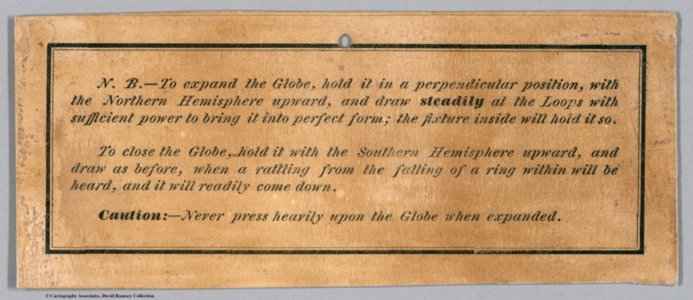
Author
Townsend, Dennis
Full Title
(Covers and Title Page to) Townsend's Patent Folding Globe. Publishers: George C. Smith & Co. ... Boston, Mass. Dennis Townsend, Felchville, Windsor County, Vt. Edward E. Rice & Co. ... Boston, Mass.
List No
12223.001
Note
Stiff yellow boards with title in brown and green ink. Includes endorsements by two college presidents. Dark green spine.
Author
Townsend, Dennis
Full Title
(Globe Gores) (Northern Hemisphere). Patented by Dennis Townsend, Feb. 16, 1869.
List No
12223.003
Author
Townsend, Dennis
Full Title
(Globe Gores) (Southern Hemisphere).
List No
12223.004
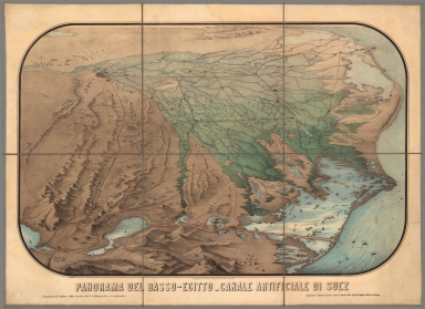
Author
Vimercati, Cesare
Full Title
Panorama del Basso-Egitto - Canale Artificiale di Suez. Proprieta C. Vimercati posta sotto la tutela delle vigenti Leggi in fatto di stampa. Rapporto di 1:260 000 sulla scala di 2 chilometri a centimetro.
List No
11001.000
Note
Color panoramic view of the Nile River Delta and the Suez Canal region, on sheet 70x97, dissected into 6 sections, mounted on linen, 35x32.5. Shows settlements, roads and trails. Date estimated. Relief shown pictorially.
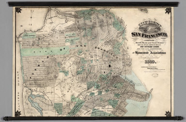
Author
Goddard, George H.
Full Title
City and County of San Francisco. Compiled from U.S. Land and Coast Surveys from the Official Surveys of the City, The Outside Lands. The Tide Land Commission and the Homestead Associations by George H. Goddard C.E. 1869. Lithographed & Published by Britton & Rey, Corr. Commercial & Leidesdorff Sts. S. Entered ... 1869.
List No
7819.000
Note
Shows in tint the tidelands, homestead areas, parks, and cemeteries. There is property information and street layouts that appear to be unique to this map, compared to other San Francisco maps of the same period. Wall map mounted on linen with decorative black sticks at top and bottom.
Author
United States Coast Survey
Full Title
San Francisco Peninsula. U.S. Coast Survey. Benjamin Peirce, Superintendent. 1869. Price $1.50. Verified J.E. Hilgard. Assist Coast Survey. In Charge of Office.
List No
2648.000
Note
Heavy paper chart; uses contour lines. This is one of the first Coast Survey charts that we have seen that uses contour lines, other than the 1859 City of San Francisco and Its Vicinity (see our copy). Map without color. Published as map #14 in the "Report of the Superintendent of the United States Coast Survey, Showing the Progress of the Survey During the Year 1869." The report was finally published in 1872 and was the House of Representatives report from the 41st Congress, 2d Session, Ex. Doc. No. 206.
Author
[Vuillemin, A., Migeon, J.]
Full Title
(Second Title Page) La France. Nouvel Atlas Illustre des Departments & des Colonies, d'Apres La Cartes de Cassini, du Depot de la Guerre, des Ponts-det-Chaussees et de la Marine par M. Vuillemin, Ingenieur-Geographele. Migeon, Editeur.
List No
8774.003
Note
Title inset in large drawing.
Author
[Vuillemin, A., Migeon, J.]
Full Title
Seine.
List No
8774.154
Author
Cram, George Franklin
Full Title
(Covers to) New Rail Road & township map of Missouri and Kansas : Published by Geo. F. Cram & Co. Western Map Depot. 148 Lake Street, Chicago Ills.
List No
7827.001
Note
Regional Cram's pocket map, 1st. edition. With full color map, 37X79, with 3 vignettes. Folded into black cloth covers 14x9 with "New Rail-Road & Township Map Of Kansas and Missouri : Published By Geo. F. Cram & Co." in gilt. Geo. F. Cram & Co. advertisement on verso of front cover.
Author
Cram, George Franklin
Full Title
New Rail Road & township map of Missouri and Kansas : Published by Geo. F. Cram & Co. Western Map Depot. 148 Lake Street, Chicago Ills.
List No
7827.002
Note
Outline color regional map, with 3 vignettes. Folded into black cloth covers 14x9 with "New Rail-Road & Township Map Of Kansas and Missouri : Published By Geo. F. Cram & Co." in gilt. Identifies counties and clearly shows railroad lines.
Author
[Alaskan Boundary Tribunal, U.S. Coast Survey]
Full Title
(Facsimile) Tracing of part of "Alaska" shewing "Stakeen (Stickeen) River" from U.S. Coast Survey of 1869. Certified, Domn. Lands Office, Jan. 16th. 1878. The Burland Desbarats Lith. Co. Montreal.
List No
0009.028
Note
Color. Relief shown by hachures.
Author
[Alaskan Boundary Tribunal, Imray, James]
Full Title
(Facsimile) North Pacific (portion), London Published by James Imray and Son, 89 Minories and Tower Hill, 1869. Alaskan Boundary Tribunal, 1903. 33. Andrew B. Graham. Photo-Litho. Washington.D.C.
List No
0009.080
Author
Colton, G.W.
Full Title
(Covers to) Colton's General Atlas, Containing One Hundred And Eighty Steel Plate Maps And Plans, On One Hundred And Nineteen Imperial Folio Sheets, Drawn By G. Woolworth Colton. Letter-Press Descriptions, Geographical, Statistical, And Historical, By Richard Swainson Fisher. New York: G.W. & C.B. Colton, No. 172 William Street. 1874. Entered ... 1863, by J.H. Colton ... New York.
List No
0152.001
Note
Covers are black half leather, dark green cloth covered boards with "Colton's General Atlas With Descriptions." stamped in gilt on the front. Spine reads "Colton's General Atlas. " Back cover blind stamped.
Author
Colton, G.W.
Full Title
(Frontispiece to) Colton's General Atlas, Containing One Hundred And Eighty Steel Plate Maps And Plans, On One Hundred And Nineteen Imperial Folio Sheets, Drawn By G. Woolworth Colton. Letter-Press Descriptions, Geographical, Statistical, And Historical, By Richard Swainson Fisher. New York: G.W. & C.B. Colton, No. 172 William Street. 1874. Entered ... 1863, by J.H. Colton ... New York.
List No
0152.002
Note
Vignette showing four women studying the globe surrounded by symbols of learning, time, arts, civilization, and navigation.
Author
Colton, G.W.
Full Title
(Title Page to) Colton's General Atlas, Containing One Hundred And Eighty Steel Plate Maps And Plans, On One Hundred And Nineteen Imperial Folio Sheets, Drawn By G. Woolworth Colton. Letter-Press Descriptions, Geographical, Statistical, And Historical, By Richard Swainson Fisher. New York: G.W. & C.B. Colton, No. 172 William Street. 1869. Entered ... 1863, by J.H. Colton ... New York.
List No
0152.003
Author
Colton, G.W.
Full Title
(Contents to) Colton's General Atlas, Containing One Hundred And Eighty Steel Plate Maps And Plans, On One Hundred And Nineteen Imperial Folio Sheets, Drawn By G. Woolworth Colton. Letter-Press Descriptions, Geographical, Statistical, And Historical, By Richard Swainson Fisher. New York: G.W. & C.B. Colton, No. 172 William Street. 1874. Entered ... 1863, by J.H. Colton ... New York.
List No
0152.004
Author
Colton, G.W.
Full Title
(Text Page) Publishers' Advertisement.
List No
0152.005
Note
Discusses the sources of the various maps. Author's note: " A knowledge of Geography is most easily acquired by the study of perfect and authentic maps... The maps referring to the United States have been drawn from the public archives. The surveys made under the authority of the General Land Office and Coast-Survey Office... Maps of the country north of the United states have been chiefly drawn from the colonial Surveys...."
Author
Colton, G.W.
Full Title
National & Commercial Flags of All Nations. Published by G. W. & C. B. Colton & Co., No. 172 William St. New York.
List No
0152.006
Note
Includes: Marryats code of Commercial signals, British Admiralty code of commercial signals and Rogers code of commercial signals.
Author
Colton, G.W.
Full Title
(Text Page) Principal Rivers and Lakes in the World.
List No
0152.007
Author
Colton, G.W.
Full Title
Mountains & Rivers. Published by G. W. & C. B. Colton & Co., No. 172 William St. New York.
List No
0152.008
Note
Comparative chart showing river lengths and receiving water bodies. Another portion shows relative mountain heights and active volcanos as grouped by continent.
Author
Colton, G.W.
Full Title
(Index to) Principal Mountains in the World.
List No
0152.009
Note
Index showing mountain heights as grouped by continent.
Author
Colton, G.W.
Full Title
Comparative Size of Lakes and Islands. Lakes in the Western Hemisphere. Lakes in the Eastern Hemisphere. Islands in the Western Hemisphere. Islands in the Eastern Hemisphere. Published by G. W & C. B. Colton & Co., No. 172 William St. New York.
List No
0152.010
Note
A selection of the largest islands and lakes drawn on the same scale and differentiated by hemisphere. Includes the Black Sea with salinity about half that of oceans and includes the Caspian Sea with about one-third the salinity of oceans. Also includes some very salty lakes such as the Great Salt Lake and Mono Lake.
Author
Colton, G.W.
Full Title
Map of the World Illustrating the Principal Features of The Land and the Co-Tidal Lines. Map of the World Illustrating the Principal Features of Meteorology. Map of the World Showing the Geographical Distribution and Range of the Principal Members of Animal Kingdom. Map of the World Showing the Principal Ocean Currents and Boundaries of River Systems. Map of the World Showing the Distribution and Limits of Cultivation of the Principal Plants Useful to Mankind. Map of the World illustrating the Productive Industry of Various Countries & Exhibiting the Principal Features of Commerce and Navigation. Published by G. W & C. B. Colton & Co., No. 172 William St. New York.
List No
0152.011
Note
A selection of thematic maps illustrating the Land and Tidal Lines, Meteorology, Animal Kingdom, Ocean Currents and River Systems, Principal Plants, and Productive Industry of the World. (Inset) Rain Map. Bird Map. and Chart showing the Vertical Range of Various Plants. Prime meridian is Greenwich.
Author
Colton, G.W.
Full Title
Colton's Map of the World On Mercator's Projection. Published by G. W & C. B. Colton & Co., No. 172 William St. New York.
List No
0152.012
Note
Shows routes and dates of exploration. Prime meridians are Greenwich and Washington D.C.
Author
Colton, G.W.
Full Title
Western Hemisphere. Eastern Hemisphere. Published by G. W & C. B. Colton & Co., No. 172 William St. New York.
List No
0152.013
Note
Prime meridian is Greenwich.
Author
Colton, G.W.
Full Title
Northern Regions. Southern Regions. Published by G. W & C. B. Colton & Co., No. 172 William St. New York.
List No
0152.014
Note
Map showing Arctic and Antarctic Regions. Prime meridians are Greenwich and Washington D.C.
Author
Colton, G.W.
Full Title
Colton's North America. Published by G. W & C. B. Colton & Co., No. 172 William St. New York.
List No
0152.015
Note
Map showing United States, British Possessions, Russian America, Alaska, Mexico, Central America, West Indies, Iceland and Greenland. Prime meridian is Washington D. C. Relief shown by hachures.
Author
Colton, G.W.
Full Title
Northern America. Published by G. W & C. B. Colton & Co., No. 172 William St. New York.
List No
0152.016
Note
Prime meridians are Greenwich and Washington D.C.
Author
Colton, G.W.
Full Title
Colton's Map of the Territory of Alaska (Russian America) Ceded by Russian to the United States. (inset) Diagram of the Middle States and North America. Published by G. W & C. B. Colton & Co., No. 172 William St. New York.
List No
0152.017
Note
Prime meridian is Greenwich. Relief shown by hachures. Includes Isothermal lines by Lorin Blodget.
Author
Colton, G.W.
Full Title
Colton's Dominion of Canada, No. 1. The Provinces of Quebec and New Brunswick. Published by G. W & C. B. Colton & Co., No. 172 William St. New York.
List No
0152.018
Note
Prime meridians are Washington D.C. and Greenwich.
Author
Colton, G.W.
Full Title
Colton's Dominion of Canada, No. 2. The Province of Ontario. Published by G. W & C. B. Colton & Co., No. 172 William St. New York.
List No
0152.019
Note
Prime meridians are Washington D.C. and Greenwich.
Author
Colton, G.W.
Full Title
Colton's Dominion of Canada, No. 3. The Provinces of New Brunswick & Nova Scotia and Prince Edward Island. Published by G. W & C. B. Colton & Co., No. 172 William St. New York.
List No
0152.020
Note
Prime meridians are Washington D.C. and Greenwich.
Author
Colton, G.W.
Full Title
Colton's New Brunswick, Nova Scotia, Newfoundland. And Prince Edward Id. Published by G. W & C. B. Colton & Co., No. 172 William St. New York.
List No
0152.021
Note
Prime meridians are Washington D.C. and Greenwich.
Author
Colton, G.W.
Full Title
Colton's United States of America. Published by G. W & C. B. Colton & Co., No. 172 William St. New York.
List No
0152.022
Note
Prime meridians are Washington D.C. and Greenwich.
Author
Colton, G.W.
Full Title
Colton's Georgetown and the City of Washington the Capital of the United States of America. Published by G. W & C. B. Colton & Co., No. 172 William St. New York.
List No
0152.023
Note
Map showing districts, roads and layout of various buildings. (inset) Smithsonian Institute, The Capital and Washington Monument.
Author
Colton, G.W.
Full Title
Colton's Maine. Published by G. W & C. B. Colton & Co., No. 172 William St. New York.
List No
0152.024
Note
Prime meridians are Washington D.C. and Greenwich.
Author
Colton, G.W.
Full Title
Colton's New Hampshire. Published by G. W & C. B. Colton & Co., No. 172 William St. New York.
List No
0152.025
Note
Prime meridians are Washington D.C. and Greenwich.
Author
Colton, G.W.
Full Title
Colton's Vermont. Published by G. W & C. B. Colton & Co., No. 172 William St. New York.
List No
0152.026
Note
Prime meridians are Washington D.C. and Greenwich.
Author
Colton, G.W.
Full Title
Colton's Massachusetts, Connecticut and Rhode Island. Published by G. W & C. B. Colton & Co., No. 172 William St. New York.
List No
0152.027
Note
Prime meridians are Washington D.C. and Greenwich.
Author
Colton, G.W.
Full Title
Colton's Boston and Adjacent Cities. Published by G. W & C. B. Colton & Co., No. 172 William St. New York.
List No
0152.028
Author
Colton, G.W.
Full Title
Colton's New York. (inset) Oswego, Buffalo, Rochester, Syracuse, Albany, Troy, Vicinity of New York City. Published by G. W & C. B. Colton & Co., No. 172 William St. New York.
List No
0152.029
Note
Prime meridians are Washington D.C. and Greenwich.
Author
Colton, G.W.
Full Title
Colton's New York City, Brooklyn, Jersey City, Hoboken, Etc. Published by G. W & C. B. Colton & Co., No. 172 William St. New York.
List No
0152.030
Note
(inset) The upper part of New York City with the adjacent portion of Westchester County.
Author
Colton, G.W.
Full Title
Colton's New Jersey. Published by G. W & C. B. Colton & Co., No. 172 William St. New York.
List No
0152.031
Note
Prime meridians are Washington D.C. and Greenwich.
Author
Colton, G.W.
Full Title
Philadelphia. Published By G. W & C. B. Colton & Co. No. 172 William St. New York.
List No
0152.032
Author
Colton, G.W.
Full Title
Colton's New Township Map of the State of Pennsylvania. Published By G. W & C. B. Colton & Co. No. 172 William St. New York.
List No
0152.033
Note
Prime meridians are Washington D.C. and Greenwich.
Author
Colton, G.W.
Full Title
Colton's Baltimore, Maryland. Published By G. W & C. B. Colton & Co. No. 172 William St. New York.
List No
0152.034
Author
Colton, G.W.
Full Title
Colton's Delaware and Maryland. (inset) District of Columbia. Published By G. W & C. B. Colton & Co. No. 172 William St. New York.
List No
0152.035
Note
Prime meridians are Washington D.C. and Greenwich.
Author
Colton, G.W.
Full Title
Colton's Virginia & West Virginia. (inset) Richmond, Henrico County. Manchester and Spring Hill, Chesterfield County. Norfolk, Portsmouth and Gosport. Published By G. W & C. B. Colton & Co. No. 172 William St. New York.
List No
0152.036
Note
Prime meridians are Washington D.C. and Greenwich. Relief shown by hachures.
Author
Colton, G.W.
Full Title
Colton's North Carolina. (inset) Beaufort Harbor. Published By G. W & C. B. Colton & Co. No. 172 William St. New York.
List No
0152.037
Note
Prime meridians are Washington D.C. and Greenwich.
Author
Colton, G.W.
Full Title
Colton's South Carolina. (inset) Colton's Plan of Charleston Vicinity & Harbor. Published By G. W & C. B. Colton & Co. No. 172 William St. New York.
List No
0152.038
Note
Prime meridians are Washington D.C. and Greenwich. Includes plan of Fort Sumter.
Author
Colton, G.W.
Full Title
The City of Savannah, Georgia. The City of Charleston, South Carolina. Published By J. H. Colton. No. 172 William St. New York.
List No
0152.039
Note
The plans of Charleston & Savannah are upon the same scale.
Author
Colton, G.W.
Full Title
Colton's Georgia. Published By G. W & C. B. Colton & Co. No. 172 William St. New York.
List No
0152.040
Note
Prime meridians are Washington D.C. and Greenwich.
Author
Colton, G.W.
Full Title
Colton's Florida. (inset: Continuation of map) Florida Keys. Published By G. W & C. B. Colton & Co. No. 172 William St. New York.
List No
0152.041
Note
Prime meridians are Washington D.C. and Greenwich.
Author
Colton, G.W.
Full Title
Colton's Alabama. Published By G. W & C. B. Colton & Co. No. 172 William St. New York.
List No
0152.042
Note
Prime meridians are Washington D.C. and Greenwich.
Author
Colton, G.W.
Full Title
Colton's Mississippi. Published By G. W & C. B. Colton & Co. No. 172 William St. New York.
List No
0152.043
Note
Prime meridians are Washington D.C. and Greenwich.
Author
Colton, G.W.
Full Title
Colton's Louisiana. Published By G. W & C. B. Colton & Co. No. 172 William St. New York.
List No
0152.044
Note
Prime meridians are Washington D.C. and Greenwich.
Author
Colton, G.W.
Full Title
The City of Louisville, Kentucky. The City of New Orleans, Louisiana. Published By J. H. Colton. No. 172 William St. New York.
List No
0152.045
Note
The maps of Louisville & New Orleans are drawn upon the same scale.
Author
Colton, G.W.
Full Title
Colton's New Map of the State of Texas. Complied from J. D. Cordova's Large Map. (inset) Plan of the Northern Part of Texas. Plan of Galveston Bay. Plan of Sabine Lake. Published By G. W & C. B. Colton & Co. No. 172 William St. New York.
List No
0152.046
Note
Prime meridians are Washington D.C. and Greenwich.
Author
Colton, G.W.
Full Title
Colton's Arkansas. Published By G. W & C. B. Colton & Co. No. 172 William St. New York.
List No
0152.047
Note
Prime meridians are Washington D.C. and Greenwich.
Author
Colton, G.W.
Full Title
Colton's Kentucky and Tennessee. Published By G. W & C. B. Colton & Co. No. 172 William St. New York.
List No
0152.048
Note
Prime meridians are Washington D.C. and Greenwich.
Author
Colton, G.W.
Full Title
Colton's Ohio. (inset) Vicinity of Cleveland, Cuyahoga Co. Published By G. W & C. B. Colton & Co. No. 172 William St. New York.
List No
0152.049
Note
Prime meridians are Washington D.C. and Greenwich.
Author
Colton, G.W.
Full Title
The Cities of Pittsburgh and Allegheny with Part of Adjacent Boroughs Pennsylvania. The City of Cincinnati, Ohio. Published By G. W & C. B. Colton & Co. No. 172 William St. New York.
List No
0152.050
Note
The maps of Cincinnati & Pittsburgh are drawn upon the same scale.
Author
Colton, G.W.
Full Title
Colton's Indiana. Published By G. W & C. B. Colton & Co. No. 172 William St. New York.
List No
0152.051
Note
Prime meridians is Washington D.C.
Author
Colton, G.W.
Full Title
Michigan. Published By G. W & C. B. Colton & Co. No. 172 William St. New York.
List No
0152.052
Note
Prime meridians are Washington D.C. and Greenwich.
Author
Colton, G.W.
Full Title
Colton's Lake Superior and the Northern Part of Michigan. Published By G. W & C. B. Colton & Co. No. 172 William St. New York.
List No
0152.053
Note
Prime meridians are Washington D.C. and Greenwich.
Author
Colton, G.W.
Full Title
Colton's Illinois. (inset) Plan of Cook county & Vicinity of Chicago. Published By G. W & C. B. Colton & Co. No. 172 William St. New York.
List No
0152.054
Author
Colton, G.W.
Full Title
The City of St. Louis, Missouri. The City of Chicago, Illinois. Published By G. W & C. B. Colton & Co. No. 172 William St. New York.
List No
0152.055
Note
The plans of Chicago & St. Louis are upon the same scale.
Author
Colton, G.W.
Full Title
Colton's Missouri. (inset) Vicinity of St. Louis. Published By G. W & C. B. Colton & Co. No. 172 William St. New York.
List No
0152.056
Note
Prime meridians are Washington D.C. and Greenwich.
Author
Colton, G.W.
Full Title
Colton's Wisconsin. (inset) Vicinity of Milwaukee. Published By G. W & C. B. Colton & Co. No. 172 William St. New York.
List No
0152.057
Note
Prime meridians are Washington D.C. and Greenwich.
Author
Colton, G.W.
Full Title
Colton's Minnesota. Published By G. W & C. B. Colton & Co. No. 172 William St. New York.
List No
0152.058
Note
Prime meridians are Washington D.C. and Greenwich.
Author
Colton, G.W.
Full Title
Colton's Iowa. Published By G. W & C. B. Colton & Co. No. 172 William St. New York.
List No
0152.059
Note
Prime meridians are Washington D.C. and Greenwich. The colored lines & figures, show the Congressional Districts.
Author
Colton, G.W.
Full Title
Colton's Indian Territory. Drawn from maps & Surveys Furnished by the Engineer Bureau, War Department, U. S. Published By G. W & C. B. Colton & Co. No. 172 William St. New York.
List No
0152.060
Note
Prime meridian is Greenwich.
Author
Colton, G.W.
Full Title
Colton's Nebraska. Published By G. W & C. B. Colton & Co. No. 172 William St. New York.
List No
0152.061
Note
Prime meridians are Washington D.C. and Greenwich.
Author
Colton, G.W.
Full Title
Colton's Dakota and Wyoming. Published By G. W & C. B. Colton & Co. No. 172 William St. New York.
List No
0152.062
Note
Prime meridians are Washington D.C. and Greenwich.
Author
Colton, G.W.
Full Title
Colton's Kansas. Published By G. W & C. B. Colton & Co. No. 172 William St. New York.
List No
0152.063
Note
Prime meridians are Washington D.C. and Greenwich.
Author
Colton, G.W.
Full Title
Colton's Map of California, Nevada, Utah, Colorado, Arizona and New Mexico. Published By G. W & C. B. Colton & Co. No. 172 William St. New York.
List No
0152.064
Note
Prime meridians are Washington D.C. and Greenwich.
Author
Colton, G.W.
Full Title
Colton's Oregon, Washington, Idaho, Montana and British Columbia. Published By G. W & C. B. Colton & Co. No. 172 William St. New York.
List No
0152.065
Note
Prime meridians are Washington D.C. and Greenwich.
Author
Colton, G.W.
Full Title
Colton's Mexico. (inset) Territory and Isthmus of Tehuantepec. Published By G. W & C. B. Colton & Co. No. 172 William St. New York.
List No
0152.066
Note
Prime meridians are Washington D.C. and Greenwich.
Author
Colton, G.W.
Full Title
Colton's Central America. (inset) Isthmus of Panama. Harbor of San Juan, Nicaragua. The Nicaragua Route. Manzanilla Id., Aspinwall City, Navy Bay. City of Panama. Published By G. W & C. B. Colton & Co. No. 172 William St. New York.
List No
0152.067
Note
Prime meridians are Washington D.C. and Greenwich.
Author
Colton, G.W.
Full Title
Colton's West Indies. (inset) The Bermuda Islands. City and Harbor of Havana. Published By G. W & C. B. Colton & Co. No. 172 William St. New York.
List No
0152.068
Note
Prime meridians are Washington D.C. and Greenwich.
Author
Colton, G.W.
Full Title
Colton's Cuba, Jamaica and Porto (Puerto) Rico. (inset) Porto (Puerto) Rico. Published By G. W & C. B. Colton & Co. No. 172 William St. New York.
List No
0152.069
Note
Prime meridians are Washington D.C. and Greenwich.
Author
Colton, G.W.
Full Title
Colton's South America. Published By G. W & C. B. Colton & Co. No. 172 William St. New York.
List No
0152.070
Note
Prime meridians are Washington D.C. and Greenwich.
Author
Colton, G.W.
Full Title
Colton's Venezuela, United States of Colombia or New Granada and Ecuador. Published By G. W & C. B. Colton & Co. No. 172 William St. New York.
List No
0152.071
Note
Prime meridians are Washington D.C. and Greenwich.
Author
Colton, G.W.
Full Title
Colton's Brazil and Guayana. (inset) Pernambuco and Rio de Janeiro. Published By G. W & C. B. Colton & Co. No. 172 William St. New York.
List No
0152.072
Note
Prime meridians are Washington D.C. and Greenwich.
Author
Colton, G.W.
Full Title
Colton's Peru and Bolivia. (inset) City of Lima. Published By G. W & C. B. Colton & Co. No. 172 William St. New York.
List No
0152.073
Note
Prime meridians are Washington D.C. and Greenwich. Relief shown by hachures.
Author
Colton, G.W.
Full Title
Colton's Argentina Republic, Chili, Uruguay & Paraguay. Published By G. W & C. B. Colton & Co. No. 172 William St. New York.
List No
0152.074
Note
Prime meridians are Washington D.C. and Greenwich.
Author
Colton, G.W.
Full Title
Colton's Patagonia. South Orkney or Powell's Group. Falkland Islands. South Georgia Island. Published By G. W & C. B. Colton & Co. No. 172 William St. New York.
List No
0152.075
Note
Prime meridians are Washington D.C. and Greenwich. Relief shown by hachures.
Author
Colton, G.W.
Full Title
Colton's Europe. Published By G. W & C. B. Colton & Co. No. 172 William St. New York.
List No
0152.076
Note
Prime meridians are Washington D.C. and Greenwich.
Author
Colton, G.W.
Full Title
Colton's England and Wales. (inset) Scilly Isles. Published By G. W & C. B. Colton & Co. No. 172 William St. New York.
List No
0152.077
Note
Prime meridians are Washington D.C. and Greenwich.
Author
Colton, G.W.
Full Title
The Environs of London. Published By G. W & C. B. Colton & Co. No. 172 William St. New York.
List No
0152.078
Note
Printed in black and white. Prime meridian replaced by measure of distance from the General Post Office.
Author
Colton, G.W.
Full Title
Scotland. (inset) Orkney Isles. and Shetland Isles. Published By G. W & C. B. Colton & Co. No. 172 William St. New York.
List No
0152.079
Note
Prime meridians are Washington D.C. and Greenwich.
Author
Colton, G.W.
Full Title
Colton's Ireland. Published By G. W & C. B. Colton & Co. No. 172 William St. New York.
List No
0152.080
Note
Prime meridians are Washington D.C. and Greenwich.
Author
Colton, G.W.
Full Title
Colton's France. (inset) Corsica. Published By G. W & C. B. Colton & Co. No. 172 William St. New York.
List No
0152.081
Note
Prime meridians are Washington D.C. and Greenwich. Relief shown by hachures.
Author
Colton, G.W.
Full Title
The Environs of Paris. Published By G. W & C. B. Colton & Co. No. 172 William St. New York.
List No
0152.082
Note
Relief shown by hachures. Map printed in black and white.
Author
Colton, G.W.
Full Title
Colton's Spain and Portugal. (inset) Gibraltar. Published By G. W & C. B. Colton & Co. No. 172 William St. New York.
List No
0152.083
Note
Prime meridians are Washington D.C. and Greenwich.
Author
Colton, G.W.
Full Title
Colton's Holland and Belgium. (inset) Amsterdam and Brussels. Published By G. W & C. B. Colton & Co. No. 172 William St. New York.
List No
0152.084
Note
Prime meridians are Washington D.C. and Greenwich.
Author
Colton, G.W.
Full Title
Colton's Denmark. (insets) Iceland. Bornholm. Die Faeroer or Faroe Islands. Published By G. W & C. B. Colton & Co. No. 172 William St. New York.
List No
0152.085
Note
Prime meridians are Washington D.C. and Greenwich.
Author
Colton, G.W.
Full Title
Colton's Sweden and Norway. Published By G. W & C. B. Colton & Co. No. 172 William St. New York.
List No
0152.086
Note
Prime meridians are Washington D.C. and Greenwich.
Author
Colton, G.W.
Full Title
Russia. Published By G. W & C. B. Colton & Co. No. 172 William St. New York.
List No
0152.087
Note
Prime meridians are Washington D.C. and Greenwich.
Author
Colton, G.W.
Full Title
Colton's Prussia and Saxony. Published By G. W & C. B. Colton & Co. No. 172 William St. New York.
List No
0152.088
Note
Prime meridians are Greenwich and Washington D. C.
Author
Colton, G.W.
Full Title
Colton's Germany, No. 1. (inset) Berlin and Hamburg. Published By G. W & C. B. Colton & Co. No. 172 William St. New York.
List No
0152.089
Note
Prime meridians are Greenwich and Washington D. C.
Author
Colton, G.W.
Full Title
Colton's Germany, No. 2. Published By G. W & C. B. Colton & Co. Colton. No. 172 William St. New York.
List No
0152.090
Note
Prime meridians are Greenwich and Washington D. C.
Author
Colton, G.W.
Full Title
Colton's Germany, No. 3. Published By G. W & C. B. Colton & Co. No. 172 William St. New York.
List No
0152.091
Note
Prime meridians are Greenwich and Washington D. C.
Author
Colton, G.W.
Full Title
Colton's Austria. (inset) Vicinity of Vienna. Published By G. W & C. B. Colton & Co. No. 172 William St. New York.
List No
0152.092
Note
Prime meridians are Greenwich and Washington D. C.
Author
Colton, G.W.
Full Title
Colton's Switzerland. Published By G. W & C. B. Colton & Co. No. 172 William St. New York.
List No
0152.093
Note
Prime meridians are Greenwich and Washington D. C.
Author
Colton, G.W.
Full Title
Colton's Northern Italy. Published By G. W & C. B. Colton & Co. No. 172 William St. New York.
List No
0152.094
Note
Prime meridians are Greenwich and Washington D. C.
Author
Colton, G.W.
Full Title
Colton's Southern Italy. (inset) Malta and its Dependencies. Published By G. W & C. B. Colton & Co. No. 172 William St. New York.
List No
0152.095
Note
Prime meridians are Greenwich and Washington D. C. Relief shown by hachures.
Author
Colton, G.W.
Full Title
Colton's Turkey in Europe. (inset) The Bosphorus. Candia or Crete. Published By G. W & C. B. Colton & Co. No. 172 William St. New York.
List No
0152.096
Note
Prime meridians are Greenwich and Washington D. C.
Author
Colton, G.W.
Full Title
Colton's Greece and the Ionian Republic. Published By G. W & C. B. Colton & Co. No. 172 William St. New York.
List No
0152.097
Note
Prime meridians Greenwich and Washington D.C.
Author
Colton, G.W.
Full Title
Colton's Asia. Published By G. W & C. B. Colton & Co. No. 172 William St. New York.
List No
0152.098
Note
Prime meridians are Greenwich and Washington D. C.
Author
Colton, G.W.
Full Title
Colton's Turkey in Asia and the Caucasian Provinces of Russia. Published By G. W & C. B. Colton & Co. No. 172 William St. New York.
List No
0152.099
Note
Prime meridian is Washington D. C.
Author
Colton, G.W.
Full Title
Colton's Palestine. (inset) Arabia Petraea. Published By G. W & C. B. Colton & Co. No. 172 William St. New York.
List No
0152.100
Note
Prime meridians are Greenwich and Washington D.C.
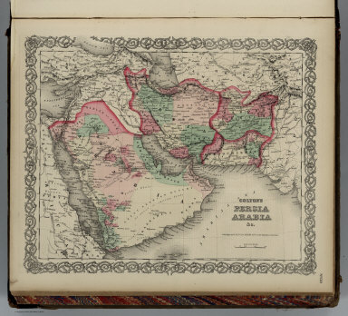
Author
Colton, G.W.
Full Title
Colton's Persia Arabia & C. Published By G. W & C. B. Colton & Co. No. 172 William St. New York.
List No
0152.101
Note
Prime meridians are Greenwich and Washington D. C.
Author
Colton, G.W.
Full Title
Colton's Hindoostan or British India. Published By G. W & C. B. Colton & Co. No. 172 William St. New York.
List No
0152.102
Note
Prime meridians are Greenwich and Washington D. C. Relief shown by hachures. (inset) Continuation of British India.
Author
Colton, G.W.
Full Title
Colton's China. (inset) Harbor & Island of Amoy, Map of Canton and Adjacent Islands. Published By G. W & C. B. Colton & Co. No. 172 William St. New York.
List No
0152.103
Note
Prime meridians are Greenwich and Washington D. C.
Author
Colton, G.W.
Full Title
Colton's Japan, Nippon, Kiusiu, Sikok, Yesso and the Japanese Kuriles. (inset) Yesso and the Japanese Kuriles and Bay of Nagasaki. Published By G. W & C. B. Colton & Co. No. 172 William St. New York.
List No
0152.104
Note
Prime meridians are Greenwich and Washington D. C.
Author
Colton, G.W.
Full Title
Africa. North Eastern Sheet. (Inset) Delta of the Nile. Published By G. W & C. B. Colton & Co. No. 172 William St. New York.
List No
0152.105
Note
Prime meridians are Greenwich and Washington D. C. Relief shown by hachures.
Author
Colton, G.W.
Full Title
Africa. North Western Sheet. (Inset) Liberia. Published By G. W & C. B. Colton & Co. No. 172 William St. New York.
List No
0152.106
Note
Prime meridians are Greenwich and Washington D. C.
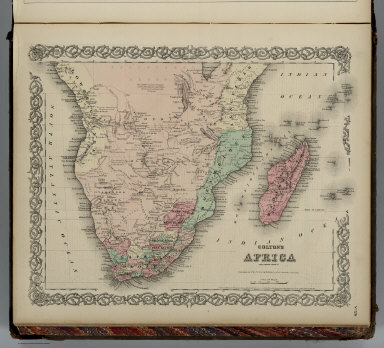
Author
Colton, G.W.
Full Title
Colton's Africa Southern Sheet. Published By G. W & C. B. Colton & Co. No. 172 William St. New York.
List No
0152.107
Note
Prime meridians are Greenwich and Washington D. C.
Author
Colton, G.W.
Full Title
Colton's Australia. Published By G. W & C. B. Colton & Co. No. 172 William St. New York.
List No
0152.108
Note
Prime meridians are Greenwich and Washington D. C.
Author
Colton, G.W.
Full Title
Colton's East Indies. (inset) Island and strait of Singapore. Published By G. W & C. B. Colton & Co. No. 172 William St. New York.
List No
0152.109
Note
Prime meridians are Greenwich and Washington D. C. Relief shown by hachures.
Author
Colton, G.W.
Full Title
Colton's Hawaiian Group or Sandwich Islands. New Zealand. Viti Group or Feejee (Fiji) Islands. Tonga or Friendly Is. Samon or Navigators Is. Society Islands. Marquesas or Washington Is. Calapacos Islands. Surveyed by the U. S. Exploring Expedition, 1839-1841. Published By G. W & C. B. Colton & Co. No. 172 William St. New York.
List No
0152.110
Note
Prime meridians are Greenwich and Washington D. C. Discovery dates and discoverer are noted on each map.
Author
Colton, G.W. & C.B.
Full Title
(Covers to) Colton's New Railroad Map Of The United States & Canada, Published by G.W. And C.B. Colton, & Co. 172 William St. New York. 1869. Entered ... 1861, by J.H. Goldthwait ... New York. (inset) Map Of The Great Railroad Routes from the Middle Atlantic Ports To The Mississippi River. (inset) Map Of The Railroads Of New England And Eastern N. York. (inset) The Northern Hemisphere On A Polar Projection, Showing the time on each meridian as compared with Washington noon, and the longest day for different latitudes.
List No
0159.001
Note
First edition by Colton - Modelski lists only an 1871 Colton edition. Shows the entire U.S. with three inset maps. The U.S. map is the same as the one that appears in Colton's General Atlas; the three inset maps are copyrighted by J.H. Goldthwait in 1861 - Goldthwait issued a similar map in 1861 (Modelski 42) that this is derived from. Full color by state. Map is folded into dark brown cloth covers 16x10 with "Colton's Railroad Map Of The United States G.W. & C.B. Colton & Co" in gilt. Prime meridians are Greenwich and Washington D.C.
Author
Colton, G.W. & C.B.
Full Title
Colton's New Railroad Map Of The United States & Canada, Published by G.W. And C.B. Colton, & Co. 172 William St. New York. 1869. Entered ... 1861, by J.H. Goldthwait ... New York. (inset) Map Of The Great Railroad Routes from the Middle Atlantic Ports To The Mississippi River. (inset) Map Of The Railroads Of New England And Eastern N. York. (inset) The Northern Hemisphere On A Polar Projection, Showing the time on each meridian as compared with Washington noon, and the longest day for different latitudes.
List No
0159.002
Note
First edition by Colton - Modelski lists only an 1871 Colton edition. Shows the entire U.S. with three inset maps. The U.S. map is the same as the one that appears in Colton's General Atlas; the three inset maps are copyrighted by J.H. Goldthwait in 1861 - Goldthwait issued a similar map in 1861 (Modelski 42) that this is derived from. Full color by state. Map is folded into dark brown cloth covers 16x10 with "Colton's Railroad Map Of The United States G.W. & C.B. Colton & Co" in gilt. Prime meridians are Greenwich and Washington D.C.
Author
Colton, G.W. & C.B.
Full Title
(Covers to) Colton's Railroad & Commercial Atlas Of The United States, Canada Etc. Map No. 5. Michigan, Wisconsin & Minnesota. Published by G.W. & C.B. Colton. & Co. New York, 1869.
List No
0160.001
Note
This map is one of several pocket maps that Colton published as a "Railroad & Commercial Atlas of the United States..." These are probably descendants of an earlier series on the same scale that Colton published for H.V. Poor in 1860 - see Modelski North America plate 28 and Modelski 111 and 121. See also our #3940. These must have been among the largest scale regional railroad maps of the period. Full color by county, folded into stamped dark brown cloth covers 16x10 with "G. Woolworth Colton's County & Distance Railroad Map of Michigan, Wisconsin, & Minnesota. Showing every Station &c" in gilt. Prime meridians are Greenwich and Washington D.C.
Author
Colton, G.W. & C.B.
Full Title
Colton's Railroad & Commercial Atlas Of The United States, Canada Etc. Map No. 5. Michigan, Wisconsin & Minnesota. Published by G.W. & C.B. Colton. & Co. New York, 1869.
List No
0160.002
Note
This map is one of several pocket maps that Colton published as a "Railroad & Commercial Atlas of the United States..." These are probably descendants of an earlier series on the same scale that Colton published for H.V. Poor in 1860 - see Modelski North America plate 28 and Modelski 111 and 121. See also our #3940. These must have been among the largest scale regional railroad maps of the period. Full color by county, folded into stamped dark brown cloth covers 16x10 with "G. Woolworth Colton's County & Distance Railroad Map of Michigan, Wisconsin, & Minnesota. Showing every Station &c" in gilt. Prime meridians are Greenwich and Washington D.C.
Author
Colton, G.W. & C.B.
Full Title
(Covers to) Colton's New Township Map of Pennsylvania & the Southern Counties Of New York. Published By G.W. & C.B. Colton & Co. 172 William Street, New York. 1869. Drawn, Engraved, Printed and colored at Coltons Geographical Establishment. No. 172 William St. New York., Entered ... 1866, by G.W. & C.B. Colton, ... New York.
List No
0161.001
Note
First edition was 1866. This large scale map was one of the most detailed Pennsylvania maps of its period (exceeded only by Colton's "New Township Map of the Eastern Counties of Pennsylvania" - our our #168). Full color by township, folded into dark brown cloth cover 16x10 with "Colton's Township Map of Pennsylvania And The Southern Counties Of New-York G.W. & C.B. Colton & Co." in gilt. Prime meridian is Washington D.C. Relief shown by hachures.
Author
Colton, G.W. & C.B.
Full Title
Colton's New Township Map of Pennsylvania & the Southern Counties Of New York. Published By G.W. & C.B. Colton & Co. 172 William Street, New York. 1869. Drawn, Engraved, Printed and colored at Coltons Geographical Establishment. No. 172 William St. New York., Entered ... 1866, by G.W. & C.B. Colton, ... New York.
List No
0161.002
Note
First edition was 1866. This large scale map was one of the most detailed Pennsylvania maps of its period (exceeded only by Colton's "New Township Map of the Eastern Counties of Pennsylvania" - our our #168). Full color by township, folded into dark brown cloth cover 16x10 with "Colton's Township Map of Pennsylvania And The Southern Counties Of New-York G.W. & C.B. Colton & Co." in gilt. Prime meridian is Washington D.C. Relief shown by hachures.
Author
[Colton, G.W., Colton, C.B., Gray, O.W.]
Full Title
Missouri. Entered ... 1869 by G.W. & C.B. Colton & Co.
List No
0312.045
Author
Stieler, Adolf
Full Title
Stieler's Hand-Atlas ... No. 4. Planeten_System der Sonne.
List No
0960.008
Note
Revision of 1825 edition.
Author
Stieler, Adolf
Full Title
Stieler's Hand-Atlas ... No. 35a. Die Meerenge von Gibraltar. (inset) Gibraltar. Das Spanische Gebiet von Ceute.
List No
0960.062
Author
[Stieler, Adolf, Petermann, A.]
Full Title
Stieler's Hand-Atlas ... No. 38b. Die Europaeische Turkei. (inset) Der Bosphorus, Constantinopel.
List No
0960.074
Author
Stieler, Adolf
Full Title
Stieler's Hand-Atlas ... No. 41b. Polar-Karte.
List No
0960.077
Note
Revised from 1832, 1855 and 1868 editions.
Author
[Stieler, Adolf, Petermann, A.]
Full Title
Stieler's Hand-Atlas ... No. 42a. Sud-Polar-Karte.
List No
0960.079
Note
Shows routes of marine exploration.
Author
[Berghaus, Hermann, Stieler, Adolf]
Full Title
Stieler's Hand-Atlas ... No. 48. West-Indien und Central-Amerika. (insets) Isthmus von Nicaragua. Isthmus von Panama.
List No
0960.087
Note
Includes profile of mountains.
Author
U.S. Coast Survey
Full Title
U.S. Coast Survey A.D. Bache, Superintendent Reconnaissance Of The Western Coast Of The United States, Middle Sheet, From San Francisco To Umpquah River. By the Hydrographic Party under the command of Lieut. James Alden U.S.N. Assist. Geographical Positions by G. Davidson Assistant. 1854. Corrected to 1869. Drawn by W.B. McMurtrie; Reduction for engraving by A. Lindenkohl. Engd. by G. McCoy, J. Knight, J.L Hazzard & G.B. Metzeroth. No. 602. Electrotype Copy No. 6 by G. Mathiot U.S.C.S.
List No
1043.000
Note
Without color. Middle sheet. Issued as a separate. 1st edition 1854. Latest edition in the annual reports is 1864. Map has 12 beautiful view of the Pacific coastline. Includes text and tables. Relief shown by hachures. Soundings in fathoms.
Author
[Reymann, Daniel Gottfried, Flemming, Carl]
Full Title
184 Hof
List No
10605.247
Note
Date is the latest date in the series. The range of dates of the sheets is 1822 to 1865
Author
[Reymann, Daniel Gottfried, Flemming, Carl]
Full Title
257 Augsburg
List No
10605.316
Note
Date is the latest date in the series. The range of dates of the sheets is 1822 to 1865
Author
Kongelige Danske Søkort-Arkiv
Full Title
Islands (vestkyst) Stykkisholmr medGRundar-og Kolgrafa-Fjoror. 1869
List No
10981.000
Note
Updated to 1891.
Author
Scheda, Josef, Ritter von, 1815-1888
Full Title
(Covers to) General-Karte der Europaeischen Turkei und des Konigreiches Griechenland. Herausgegeben von Josef Ritter v. Scheda. K.K. Oesterr Oberst. (with) Plan von Constantinopel.
List No
11517.003
Note
1 color map of Ottoman Empire in Europe and Kingdom of Greece on 13 sheets, dissected and mounted on linen; 193 x 151, sheets 53 x 53 or smaller, folded into half leather black slipcase with title "General-Karte der Europ Turkei und des Konigr Griechenland" in gilt. Relief shown by shading. Includes index map on additional sheet and inset "Plan von Constantinopel" on sheet XI. Map shows political and administrative divisions, cities, towns, roads, rivers, lakes and landmarks. Includes legend, abbreviation table and statistical table.
Author
Scheda, Josef, Ritter von, 1815-1888
Full Title
(Covers to) General-Karte der Europaeischen Turkei und des Konigreiches Griechenland. Herausgegeben von Josef Ritter v. Scheda. K.K. Oesterr Oberst. (with) Plan von Constantinopel.
List No
11517.005
Note
1 color map of Ottoman Empire in Europe and Kingdom of Greece on 13 sheets, dissected and mounted on linen; 193 x 151, sheets 53 x 53 or smaller, folded into half leather black slipcase with title "General-Karte der Europ Turkei und des Konigr Griechenland" in gilt. Relief shown by shading. Includes index map on additional sheet and inset "Plan von Constantinopel" on sheet XI. Map shows political and administrative divisions, cities, towns, roads, rivers, lakes and landmarks. Includes legend, abbreviation table and statistical table.
Author
Scheda, Josef, Ritter von, 1815-1888
Full Title
General-Karte der Europaeischen Turkei und des Konigreiches Griechenland. Herausgegeben von Josef Ritter v. Scheda. K.K. Oesterr Oberst. (with) Plan von Constantinopel.
List No
11517.006
Note
1 color map of Ottoman Empire in Europe and Kingdom of Greece on 13 sheets, dissected and mounted on linen; 193 x 151, sheets 53 x 53 or smaller, folded into half leather black slipcase with title "General-Karte der Europ Turkei und des Konigr Griechenland" in gilt. Relief shown by shading. Includes index map on additional sheet and inset "Plan von Constantinopel" on sheet XI. Map shows political and administrative divisions, cities, towns, roads, rivers, lakes and landmarks. Includes legend, abbreviation table and statistical table.
Author
Scheda, Josef, Ritter von, 1815-1888
Full Title
(Covers to) General-Karte der Europaeischen Turkei und des Konigreiches Griechenland. Herausgegeben von Josef Ritter v. Scheda. K.K. Oesterr Oberst. (with) Plan von Constantinopel.
List No
11517.007
Note
1 color map of Ottoman Empire in Europe and Kingdom of Greece on 13 sheets, dissected and mounted on linen; 193 x 151, sheets 53 x 53 or smaller, folded into half leather black slipcase with title "General-Karte der Europ Turkei und des Konigr Griechenland" in gilt. Relief shown by shading. Includes index map on additional sheet and inset "Plan von Constantinopel" on sheet XI. Map shows political and administrative divisions, cities, towns, roads, rivers, lakes and landmarks. Includes legend, abbreviation table and statistical table.
Author
Scheda, Josef, Ritter von, 1815-1888
Full Title
General-Karte der Europaeischen Turkei und des Konigreiches Griechenland. Herausgegeben von Josef Ritter v. Scheda. K.K. Oesterr Oberst. (with) Plan von Constantinopel.
List No
11517.008
Note
1 color map of Ottoman Empire in Europe and Kingdom of Greece on 13 sheets, dissected and mounted on linen; 193 x 151, sheets 53 x 53 or smaller, folded into half leather black slipcase with title "General-Karte der Europ Turkei und des Konigr Griechenland" in gilt. Relief shown by shading. Includes index map on additional sheet and inset "Plan von Constantinopel" on sheet XI. Map shows political and administrative divisions, cities, towns, roads, rivers, lakes and landmarks. Includes legend, abbreviation table and statistical table.
Author
Scheda, Josef, Ritter von, 1815-1888
Full Title
(Covers to) General-Karte der Europaeischen Turkei und des Konigreiches Griechenland. Herausgegeben von Josef Ritter v. Scheda. K.K. Oesterr Oberst. (with) Plan von Constantinopel.
List No
11517.009
Note
1 color map of Ottoman Empire in Europe and Kingdom of Greece on 13 sheets, dissected and mounted on linen; 193 x 151, sheets 53 x 53 or smaller, folded into half leather black slipcase with title "General-Karte der Europ Turkei und des Konigr Griechenland" in gilt. Relief shown by shading. Includes index map on additional sheet and inset "Plan von Constantinopel" on sheet XI. Map shows political and administrative divisions, cities, towns, roads, rivers, lakes and landmarks. Includes legend, abbreviation table and statistical table.
Author
Scheda, Josef, Ritter von, 1815-1888
Full Title
General-Karte der Europaeischen Turkei und des Konigreiches Griechenland. Herausgegeben von Josef Ritter v. Scheda. K.K. Oesterr Oberst. (with) Plan von Constantinopel.
List No
11517.010
Note
1 color map of Ottoman Empire in Europe and Kingdom of Greece on 13 sheets, dissected and mounted on linen; 193 x 151, sheets 53 x 53 or smaller, folded into half leather black slipcase with title "General-Karte der Europ Turkei und des Konigr Griechenland" in gilt. Relief shown by shading. Includes index map on additional sheet and inset "Plan von Constantinopel" on sheet XI. Map shows political and administrative divisions, cities, towns, roads, rivers, lakes and landmarks. Includes legend, abbreviation table and statistical table.
Author
Scheda, Josef, Ritter von, 1815-1888
Full Title
(Covers to) General-Karte der Europaeischen Turkei und des Konigreiches Griechenland. Herausgegeben von Josef Ritter v. Scheda. K.K. Oesterr Oberst. (with) Plan von Constantinopel.
List No
11517.011
Note
1 color map of Ottoman Empire in Europe and Kingdom of Greece on 13 sheets, dissected and mounted on linen; 193 x 151, sheets 53 x 53 or smaller, folded into half leather black slipcase with title "General-Karte der Europ Turkei und des Konigr Griechenland" in gilt. Relief shown by shading. Includes index map on additional sheet and inset "Plan von Constantinopel" on sheet XI. Map shows political and administrative divisions, cities, towns, roads, rivers, lakes and landmarks. Includes legend, abbreviation table and statistical table.
Author
Scheda, Josef, Ritter von, 1815-1888
Full Title
General-Karte der Europaeischen Turkei und des Konigreiches Griechenland. Herausgegeben von Josef Ritter v. Scheda. K.K. Oesterr Oberst. (with) Plan von Constantinopel.
List No
11517.012
Note
1 color map of Ottoman Empire in Europe and Kingdom of Greece on 13 sheets, dissected and mounted on linen; 193 x 151, sheets 53 x 53 or smaller, folded into half leather black slipcase with title "General-Karte der Europ Turkei und des Konigr Griechenland" in gilt. Relief shown by shading. Includes index map on additional sheet and inset "Plan von Constantinopel" on sheet XI. Map shows political and administrative divisions, cities, towns, roads, rivers, lakes and landmarks. Includes legend, abbreviation table and statistical table.
Author
Scheda, Josef, Ritter von, 1815-1888
Full Title
(Covers to) General-Karte der Europaeischen Turkei und des Konigreiches Griechenland. Herausgegeben von Josef Ritter v. Scheda. K.K. Oesterr Oberst. (with) Plan von Constantinopel.
List No
11517.013
Note
1 color map of Ottoman Empire in Europe and Kingdom of Greece on 13 sheets, dissected and mounted on linen; 193 x 151, sheets 53 x 53 or smaller, folded into half leather black slipcase with title "General-Karte der Europ Turkei und des Konigr Griechenland" in gilt. Relief shown by shading. Includes index map on additional sheet and inset "Plan von Constantinopel" on sheet XI. Map shows political and administrative divisions, cities, towns, roads, rivers, lakes and landmarks. Includes legend, abbreviation table and statistical table.
Author
Scheda, Josef, Ritter von, 1815-1888
Full Title
General-Karte der Europaeischen Turkei und des Konigreiches Griechenland. Herausgegeben von Josef Ritter v. Scheda. K.K. Oesterr Oberst. (with) Plan von Constantinopel.
List No
11517.014
Note
1 color map of Ottoman Empire in Europe and Kingdom of Greece on 13 sheets, dissected and mounted on linen; 193 x 151, sheets 53 x 53 or smaller, folded into half leather black slipcase with title "General-Karte der Europ Turkei und des Konigr Griechenland" in gilt. Relief shown by shading. Includes index map on additional sheet and inset "Plan von Constantinopel" on sheet XI. Map shows political and administrative divisions, cities, towns, roads, rivers, lakes and landmarks. Includes legend, abbreviation table and statistical table.
Author
Scheda, Josef, Ritter von, 1815-1888
Full Title
(Covers to) General-Karte der Europaeischen Turkei und des Konigreiches Griechenland. Herausgegeben von Josef Ritter v. Scheda. K.K. Oesterr Oberst. (with) Plan von Constantinopel.
List No
11517.015
Note
1 color map of Ottoman Empire in Europe and Kingdom of Greece on 13 sheets, dissected and mounted on linen; 193 x 151, sheets 53 x 53 or smaller, folded into half leather black slipcase with title "General-Karte der Europ Turkei und des Konigr Griechenland" in gilt. Relief shown by shading. Includes index map on additional sheet and inset "Plan von Constantinopel" on sheet XI. Map shows political and administrative divisions, cities, towns, roads, rivers, lakes and landmarks. Includes legend, abbreviation table and statistical table.
Author
Scheda, Josef, Ritter von, 1815-1888
Full Title
General-Karte der Europaeischen Turkei und des Konigreiches Griechenland. Herausgegeben von Josef Ritter v. Scheda. K.K. Oesterr Oberst. (with) Plan von Constantinopel.
List No
11517.016
Note
1 color map of Ottoman Empire in Europe and Kingdom of Greece on 13 sheets, dissected and mounted on linen; 193 x 151, sheets 53 x 53 or smaller, folded into half leather black slipcase with title "General-Karte der Europ Turkei und des Konigr Griechenland" in gilt. Relief shown by shading. Includes index map on additional sheet and inset "Plan von Constantinopel" on sheet XI. Map shows political and administrative divisions, cities, towns, roads, rivers, lakes and landmarks. Includes legend, abbreviation table and statistical table.
Author
Scheda, Josef, Ritter von, 1815-1888
Full Title
(Covers to) General-Karte der Europaeischen Turkei und des Konigreiches Griechenland. Herausgegeben von Josef Ritter v. Scheda. K.K. Oesterr Oberst. (with) Plan von Constantinopel.
List No
11517.017
Note
1 color map of Ottoman Empire in Europe and Kingdom of Greece on 13 sheets, dissected and mounted on linen; 193 x 151, sheets 53 x 53 or smaller, folded into half leather black slipcase with title "General-Karte der Europ Turkei und des Konigr Griechenland" in gilt. Relief shown by shading. Includes index map on additional sheet and inset "Plan von Constantinopel" on sheet XI. Map shows political and administrative divisions, cities, towns, roads, rivers, lakes and landmarks. Includes legend, abbreviation table and statistical table.
Author
Scheda, Josef, Ritter von, 1815-1888
Full Title
General-Karte der Europaeischen Turkei und des Konigreiches Griechenland. Herausgegeben von Josef Ritter v. Scheda. K.K. Oesterr Oberst. (with) Plan von Constantinopel.
List No
11517.018
Note
1 color map of Ottoman Empire in Europe and Kingdom of Greece on 13 sheets, dissected and mounted on linen; 193 x 151, sheets 53 x 53 or smaller, folded into half leather black slipcase with title "General-Karte der Europ Turkei und des Konigr Griechenland" in gilt. Relief shown by shading. Includes index map on additional sheet and inset "Plan von Constantinopel" on sheet XI. Map shows political and administrative divisions, cities, towns, roads, rivers, lakes and landmarks. Includes legend, abbreviation table and statistical table.
Author
Scheda, Josef, Ritter von, 1815-1888
Full Title
(Covers to) General-Karte der Europaeischen Turkei und des Konigreiches Griechenland. Herausgegeben von Josef Ritter v. Scheda. K.K. Oesterr Oberst. (with) Plan von Constantinopel.
List No
11517.019
Note
1 color map of Ottoman Empire in Europe and Kingdom of Greece on 13 sheets, dissected and mounted on linen; 193 x 151, sheets 53 x 53 or smaller, folded into half leather black slipcase with title "General-Karte der Europ Turkei und des Konigr Griechenland" in gilt. Relief shown by shading. Includes index map on additional sheet and inset "Plan von Constantinopel" on sheet XI. Map shows political and administrative divisions, cities, towns, roads, rivers, lakes and landmarks. Includes legend, abbreviation table and statistical table.
Author
Scheda, Josef, Ritter von, 1815-1888
Full Title
General-Karte der Europaeischen Turkei und des Konigreiches Griechenland. Herausgegeben von Josef Ritter v. Scheda. K.K. Oesterr Oberst. (with) Plan von Constantinopel.
List No
11517.020
Note
1 color map of Ottoman Empire in Europe and Kingdom of Greece on 13 sheets, dissected and mounted on linen; 193 x 151, sheets 53 x 53 or smaller, folded into half leather black slipcase with title "General-Karte der Europ Turkei und des Konigr Griechenland" in gilt. Relief shown by shading. Includes index map on additional sheet and inset "Plan von Constantinopel" on sheet XI. Map shows political and administrative divisions, cities, towns, roads, rivers, lakes and landmarks. Includes legend, abbreviation table and statistical table.
Author
Scheda, Josef, Ritter von, 1815-1888
Full Title
(Covers to) General-Karte der Europaeischen Turkei und des Konigreiches Griechenland. Herausgegeben von Josef Ritter v. Scheda. K.K. Oesterr Oberst. (with) Plan von Constantinopel.
List No
11517.021
Note
1 color map of Ottoman Empire in Europe and Kingdom of Greece on 13 sheets, dissected and mounted on linen; 193 x 151, sheets 53 x 53 or smaller, folded into half leather black slipcase with title "General-Karte der Europ Turkei und des Konigr Griechenland" in gilt. Relief shown by shading. Includes index map on additional sheet and inset "Plan von Constantinopel" on sheet XI. Map shows political and administrative divisions, cities, towns, roads, rivers, lakes and landmarks. Includes legend, abbreviation table and statistical table.
Author
Scheda, Josef, Ritter von, 1815-1888
Full Title
General-Karte der Europaeischen Turkei und des Konigreiches Griechenland. Herausgegeben von Josef Ritter v. Scheda. K.K. Oesterr Oberst. (with) Plan von Constantinopel.
List No
11517.022
Note
1 color map of Ottoman Empire in Europe and Kingdom of Greece on 13 sheets, dissected and mounted on linen; 193 x 151, sheets 53 x 53 or smaller, folded into half leather black slipcase with title "General-Karte der Europ Turkei und des Konigr Griechenland" in gilt. Relief shown by shading. Includes index map on additional sheet and inset "Plan von Constantinopel" on sheet XI. Map shows political and administrative divisions, cities, towns, roads, rivers, lakes and landmarks. Includes legend, abbreviation table and statistical table.
Author
Scheda, Josef, Ritter von, 1815-1888
Full Title
(Covers to) General-Karte der Europaeischen Turkei und des Konigreiches Griechenland. Herausgegeben von Josef Ritter v. Scheda. K.K. Oesterr Oberst. (with) Plan von Constantinopel.
List No
11517.023
Note
1 color map of Ottoman Empire in Europe and Kingdom of Greece on 13 sheets, dissected and mounted on linen; 193 x 151, sheets 53 x 53 or smaller, folded into half leather black slipcase with title "General-Karte der Europ Turkei und des Konigr Griechenland" in gilt. Relief shown by shading. Includes index map on additional sheet and inset "Plan von Constantinopel" on sheet XI. Map shows political and administrative divisions, cities, towns, roads, rivers, lakes and landmarks. Includes legend, abbreviation table and statistical table.
Author
Scheda, Josef, Ritter von, 1815-1888
Full Title
(Covers to) General-Karte der Europaeischen Turkei und des Konigreiches Griechenland. Herausgegeben von Josef Ritter v. Scheda. K.K. Oesterr Oberst. (with) Plan von Constantinopel.
List No
11517.025
Note
1 color map of Ottoman Empire in Europe and Kingdom of Greece on 13 sheets, dissected and mounted on linen; 193 x 151, sheets 53 x 53 or smaller, folded into half leather black slipcase with title "General-Karte der Europ Turkei und des Konigr Griechenland" in gilt. Relief shown by shading. Includes index map on additional sheet and inset "Plan von Constantinopel" on sheet XI. Map shows political and administrative divisions, cities, towns, roads, rivers, lakes and landmarks. Includes legend, abbreviation table and statistical table.
Author
Scheda, Josef, Ritter von, 1815-1888
Full Title
General-Karte der Europaeischen Turkei und des Konigreiches Griechenland. Herausgegeben von Josef Ritter v. Scheda. K.K. Oesterr Oberst. (with) Plan von Constantinopel.
List No
11517.026
Note
1 color map of Ottoman Empire in Europe and Kingdom of Greece on 13 sheets, dissected and mounted on linen; 193 x 151, sheets 53 x 53 or smaller, folded into half leather black slipcase with title "General-Karte der Europ Turkei und des Konigr Griechenland" in gilt. Relief shown by shading. Includes index map on additional sheet and inset "Plan von Constantinopel" on sheet XI. Map shows political and administrative divisions, cities, towns, roads, rivers, lakes and landmarks. Includes legend, abbreviation table and statistical table.
Author
Scheda, Josef, Ritter von, 1815-1888
Full Title
(Covers to) General-Karte der Europaeischen Turkei und des Konigreiches Griechenland. Herausgegeben von Josef Ritter v. Scheda. K.K. Oesterr Oberst. (with) Plan von Constantinopel.
List No
11517.027
Note
1 color map of Ottoman Empire in Europe and Kingdom of Greece on 13 sheets, dissected and mounted on linen; 193 x 151, sheets 53 x 53 or smaller, folded into half leather black slipcase with title "General-Karte der Europ Turkei und des Konigr Griechenland" in gilt. Relief shown by shading. Includes index map on additional sheet and inset "Plan von Constantinopel" on sheet XI. Map shows political and administrative divisions, cities, towns, roads, rivers, lakes and landmarks. Includes legend, abbreviation table and statistical table.
Author
Scheda, Josef, Ritter von, 1815-1888
Full Title
General-Karte der Europaeischen Turkei und des Konigreiches Griechenland. Herausgegeben von Josef Ritter v. Scheda. K.K. Oesterr Oberst. (with) Plan von Constantinopel.
List No
11517.028
Note
1 color map of Ottoman Empire in Europe and Kingdom of Greece on 13 sheets, dissected and mounted on linen; 193 x 151, sheets 53 x 53 or smaller, folded into half leather black slipcase with title "General-Karte der Europ Turkei und des Konigr Griechenland" in gilt. Relief shown by shading. Includes index map on additional sheet and inset "Plan von Constantinopel" on sheet XI. Map shows political and administrative divisions, cities, towns, roads, rivers, lakes and landmarks. Includes legend, abbreviation table and statistical table.
Author
Kiepert, Heinrich, 1818-1899
Full Title
Sudwestliches Deutschland. Beriechtigt 1869. Situation u. Schrift gest. v. F.W. Kliewer. (to accompany) H. Kiepert's Neuer Handatlas No. 6. Berlin BEI Dietrich Reimer.
List No
11693.013
Note
Double page hand colored in outline map. Color coded by administrative boundaries. Includes legend and abbreviation. Relief shown by hachures. Prime meridians are Ferro and Paris.
Author
Kiepert, Heinrich, 1818-1899
Full Title
West Deutschland. Beriechtigt 1869. Situation u. Schrift gest. v. W. Jack. Bergstich von C. Seitz. (to accompany) H. Kiepert's Neuer Handatlas No. 7. Berlin BEI Dietrich Reimer.
List No
11693.014
Note
Double page hand colored in outline map. Color coded by administrative boundaries. Includes legend and abbreviation. Relief shown by hachures. Prime meridians are Ferro and Paris.
Author
Kiepert, Heinrich, 1818-1899
Full Title
Nordwestliches Deutschland. Beriechtigt 1869. Situation von Bembe, Schrift gestochen von H. Herzberg. (to accompany) H. Kiepert's Neuer Handatlas No. 8. Berlin BEI Dietrich Reimer. (inset) Der nordiche theil von Schleswig.
List No
11693.015
Note
Double page hand colored in outline map. Color coded by administrative boundaries. Includes legend and abbreviation. Relief shown by hachures. Prime meridians are Ferro and Paris.
Author
Kiepert, Heinrich, 1818-1899
Full Title
Bohmen, Mahren u. Oesterreich. Beriechtigt 1869. Gestochen von J. Sulzer. (to accompany) H. Kiepert's Neuer Handatlas No. 14. Berlin BEI Dietrich Reimer.
List No
11693.021
Note
Double page hand colored in outline map. Color coded by political and administrative boundaries. Includes legend and abbreviations. Relief shown by hachures. Prime meridians are Ferro and Paris.
Author
Kiepert, Heinrich, 1818-1899
Full Title
Italien. Beriechtigt 1869. Schrift gestochen von E. Reyher.Terrain gestochen von C. Seitz. (to accompany) H. Kiepert's Neuer Handatlas No. 17. Berlin BEI Dietrich Reimer. (inset) Umgebungen von Neapel.
List No
11693.024
Note
Double page hand colored in outline map. Color coded by administrative boundaries. Includes legend and abbreviations. Relief shown by hachures. Prime meridians are Ferro and Paris.
Author
Watson, Gaylord
Full Title
(Covers to) Watson's New Map Of The Western States, Territories, Mexico, And Central America. Published by Gaylord Watson, 16 Beekman Street, New York. Chicago: W.W. Wadsworth, 135 So. Water St. Entered ... 1869, by Gaylord Watson ... New York. (inset) Central America.
List No
1176.002
Note
Shows new Wyoming. Comes from large U.S. map. Superb condition. Full color by state, folded into stamped brown cloth covers 18x12 with "Watson's New Map Of The Western Territories And Central America" in gilt.
Author
Watson, Gaylord
Full Title
Watson's New Map Of The Western States, Territories, Mexico, And Central America. Published by Gaylord Watson, 16 Beekman Street, New York. Chicago: W.W. Wadsworth, 135 So. Water St. Entered ... 1869, by Gaylord Watson ... New York. (inset) Central America.
List No
1176.001
Note
Shows new Wyoming. Comes from large U.S. map. Superb condition. Full color by state, folded into stamped brown cloth covers 18x12 with "Watson's New Map Of The Western Territories And Central America" in gilt.
Author
Townsend, Dennis
Full Title
(Text and Index Page) To the Teachers. Key. Directions for Use.
List No
12223.002
Note
Stiff yellow boards with title in brown and green ink. Includes endorsements by two college presidents. Dark green spine.
Author
Townsend, Dennis
Full Title
(Text Page) N.B - To expand the Globe ....
List No
12223.005
Note
Small insert.
Author
Townsend, Dennis
Full Title
(Advertisement for) A Globe for the Million! Novel - Beautiful - Durable - Cheap.
List No
12223.006
Author
[Bernardin Bechet, France. Conseil Royal de l'instruction publique]
Full Title
Nouveau plan de Paris divise en 20 arrondissements. 1869. Publie par Bernardin Bechet, Paris. Imp. Lith. de V. Janson. (to accompany) Atlas geographique ... 3eme partie, Geographie moderne actuelle ... 1823.
List No
13006.038
Note
Engraved hand colored folded new map of Paris. Published by Bernadine-Bechet, based on earlier map by N.J. Henriot. Covers center of Paris and immediate vicinity, divided by color into 20 departments. Shows city blocks, streets, parks, Railroads, Trains entering and leaving the city, landmarks shown pictorially. Includes alphabetical list of streets, avenues, boulevards, squares, quays, bridges, etc ... of Paris. along the borders.
Author
[Voisin, Francois Philippe, 1821-1918, Schièble, Erhard (1821 - 1880)]
Full Title
(Covers to) Compagnie universelle du Canal maritime de Suez : Carte de l'isthme. dresse sous la direction de Mr. Voisin, Dircteur G.al des Travaux, et d'apres les operations de Mr. Larousse, Ingenier-Hydrographe. E. Andriveau Goujon, editeur, 1869. Grave par Erhard. Paris - Imp. Lemercier.
List No
13106.001
Note
Chromolithograph map, on sheet 119x81, sectioned to 32 panels folded to 24x14, backed with linen. Housed in marbled slipcase with title "Suez Canal" on spine. Map covers eastern part of the Nile Delta. Shows roads and railways. Relief shown by shadings. Insets including profile of the Canal and geological cross section diagram. Seller's label of "Simon Schropp & Co., Berlin" on verso.
Author
[Meyer, Herrmann Julius, 1826-1909., Ravenstein, Ludwig]
Full Title
Karte von Britisch Nord-America, Alaska und Gronland. Gez. E.G. Revenstein in London. 1869. Bibliographischen Instituts zu Hildburghausen. (to accompany) Meyer's Hand-Atlas ... 1872.
List No
13324.114
Note
Outline hand colored map, with inset map: Sudl. theil von Britisch Columbia. Showing political and administrative boundaries, Canadian states, major cites, towns, roads, rivers and mountains. Relief shown by hachures. Includes legend.
Author
[Dormoy, Émile, Administration des Mines]
Full Title
(Covers to) Topographie souterraine du Bassin Houiller de Valenciennes par M. Émile Dormoy, Ingénieur au Corps Impérial des Mines : Cartes et plans. Paris, Imprimerie Impériale, MDCCCLXIX.
List No
14382.001
Note
Covers to Topographie souterraine du Bassin Houiller de Valenciennes. Bound in gray-colored paper. With title and imprint on front cover. Title translates to: Underground topography of the Valenciennes Coal Basin by Mr. Émile Dormoy, Engineer at the Imperial Corps of Mines : Maps and plans.
Author
[Dormoy, Émile, Administration des Mines]
Full Title
(Half Title Page to) Études de gites minéraux publiées par les soins de l'Administration des Mines.
List No
14382.002
Note
Half title page to Topographie souterraine du Bassin Houiller de Valenciennes. Title translates to: Studies of mineral deposits published by the Administration of Mines.
Author
[Dormoy, Émile, Administration des Mines]
Full Title
(Index Map to) Tableau d'assemblage de la carte topographieque souterraine du Bassin Houiller de Valenciennes relié au couchant du Bassin de Mons, Dressée par M. Emile Dormoy, Ingénieur des Mines. Imprimerie Impériale.
List No
14382.004
Note
Index map to Topographie souterraine du Bassin Houiller de Valenciennes. Features the underground topography of the Valenciennes Coal Basin, as of 1869. Relief for "coal seams" shown with contour lines. Also shows political boundaries, cities, churches, rivers, canals, railways, roads and paths. Includes a legend and bar scale given in meters. Colored engraving. Map is 41 x 63 cm, on sheet 53 x 73 cm.
Author
[Dormoy, Émile, Administration des Mines]
Full Title
Tableau d'assemblage de la carte topographieque souterraine du Bassin Houiller de Valenciennes relié au couchant du Bassin de Mons, Dressée par M. Emile Dormoy, Ingénieur des Mines. Imprimerie Impériale. (1)
List No
14382.005
Note
First sheet of topographical map to Topographie souterraine du Bassin Houiller de Valenciennes. Features the underground topography of the Valenciennes Coal Basin, as of 1869. Relief for "coal seams" shown with contour lines. Also shows political boundaries, cities, churches, rivers, canals, railways, roads and paths. Includes a bar scale given in meters. With legend on final sheet map (plate 15). Colored engraving. Map is 43 x 64 cm, on double sheet 53 x 73 cm.
Author
[Dormoy, Émile, Administration des Mines]
Full Title
Tableau d'assemblage de la carte topographieque souterraine du Bassin Houiller de Valenciennes relié au couchant du Bassin de Mons, Dressée par M. Emile Dormoy, Ingénieur des Mines. Imprimerie Impériale. (2)
List No
14382.006
Note
Second sheet of topographical map to Topographie souterraine du Bassin Houiller de Valenciennes. Features the underground topography of the Valenciennes Coal Basin, as of 1869. Relief for "coal seams" shown with contour lines. Also shows political boundaries, cities, churches, rivers, canals, railways, roads and paths. Includes a bar scale given in meters. With legend on final sheet map (plate 15). Colored engraving. Map is 43 x 64 cm, on double sheet 53 x 73 cm.
Author
[Dormoy, Émile, Administration des Mines]
Full Title
Tableau d'assemblage de la carte topographieque souterraine du Bassin Houiller de Valenciennes relié au couchant du Bassin de Mons, Dressée par M. Emile Dormoy, Ingénieur des Mines. Imprimerie Impériale. (3)
List No
14382.007
Note
Third sheet of topographical map to Topographie souterraine du Bassin Houiller de Valenciennes. Features the underground topography of the Valenciennes Coal Basin, as of 1869. Relief for "coal seams" shown with contour lines. Also shows political boundaries, cities, churches, rivers, canals, railways, roads and paths. Includes a bar scale given in meters. With legend on final sheet map (plate 15). Colored engraving. Map is 43 x 64 cm, on double sheet 53 x 73 cm.
Author
[Dormoy, Émile, Administration des Mines]
Full Title
Tableau d'assemblage de la carte topographieque souterraine du Bassin Houiller de Valenciennes relié au couchant du Bassin de Mons, Dressée par M. Emile Dormoy, Ingénieur des Mines. Imprimerie Impériale. (4)
List No
14382.008
Note
Fourth sheet of topographical map to Topographie souterraine du Bassin Houiller de Valenciennes. Features the underground topography of the Valenciennes Coal Basin, as of 1869. Relief for "coal seams" shown with contour lines. Also shows political boundaries, cities, churches, rivers, canals, railways, roads and paths. Includes a bar scale given in meters. With legend on final sheet map (plate 15). Colored engraving. Map is 43 x 64 cm, on double sheet 53 x 73 cm.
Author
[Dormoy, Émile, Administration des Mines]
Full Title
Tableau d'assemblage de la carte topographieque souterraine du Bassin Houiller de Valenciennes relié au couchant du Bassin de Mons, Dressée par M. Emile Dormoy, Ingénieur des Mines. Imprimerie Impériale. (5)
List No
14382.010
Note
Sixth sheet of topographical map to Topographie souterraine du Bassin Houiller de Valenciennes. Features the underground topography of the Valenciennes Coal Basin, as of 1869. Relief for "coal seams" shown with contour lines. Also shows political boundaries, cities, churches, rivers, canals, railways, roads and paths. Includes a bar scale given in meters. With legend on final sheet map (plate 15). Colored engraving. Map is 43 x 64 cm, on double sheet 53 x 73 cm.
Author
[Dormoy, Émile, Administration des Mines]
Full Title
Tableau d'assemblage de la carte topographieque souterraine du Bassin Houiller de Valenciennes relié au couchant du Bassin de Mons, Dressée par M. Emile Dormoy, Ingénieur des Mines. Imprimerie Impériale. (6)
List No
14382.011
Note
Seventh sheet of topographical map to Topographie souterraine du Bassin Houiller de Valenciennes. Features the underground topography of the Valenciennes Coal Basin, as of 1869. Relief for "coal seams" shown with contour lines. Also shows political boundaries, cities, churches, rivers, canals, railways, roads and paths. Includes a bar scale given in meters. With legend on final sheet map (plate 15). Colored engraving. Map is 43 x 64 cm, on double sheet 53 x 73 cm.
Author
[Dormoy, Émile, Administration des Mines]
Full Title
Tableau d'assemblage de la carte topographieque souterraine du Bassin Houiller de Valenciennes relié au couchant du Bassin de Mons, Dressée par M. Emile Dormoy, Ingénieur des Mines. Imprimerie Impériale. (7)
List No
14382.012
Note
Eighth sheet of topographical map to Topographie souterraine du Bassin Houiller de Valenciennes. Features the underground topography of the Valenciennes Coal Basin, as of 1869. Relief for "coal seams" shown with contour lines. Also shows political boundaries, cities, churches, rivers, canals, railways, roads and paths. Includes a bar scale given in meters. With legend on final sheet map (plate 15). Colored engraving. Map is 43 x 64 cm, on double sheet 53 x 73 cm.
Author
[Dormoy, Émile, Administration des Mines]
Full Title
Tableau d'assemblage de la carte topographieque souterraine du Bassin Houiller de Valenciennes relié au couchant du Bassin de Mons, Dressée par M. Emile Dormoy, Ingénieur des Mines. Imprimerie Impériale. (8)
List No
14382.013
Note
Ninth sheet of topographical map to Topographie souterraine du Bassin Houiller de Valenciennes. Features the underground topography of the Valenciennes Coal Basin, as of 1869. Relief for "coal seams" shown with contour lines. Also shows political boundaries, cities, churches, rivers, canals, railways, roads and paths. Includes a bar scale given in meters. With legend on final sheet map (plate 15). Colored engraving. Map is 43 x 64 cm, on double sheet 53 x 73 cm.
Author
[Dormoy, Émile, Administration des Mines]
Full Title
Tableau d'assemblage de la carte topographieque souterraine du Bassin Houiller de Valenciennes relié au couchant du Bassin de Mons, Dressée par M. Emile Dormoy, Ingénieur des Mines. Imprimerie Impériale. (9)
List No
14382.014
Note
Tenth sheet of topographical map to Topographie souterraine du Bassin Houiller de Valenciennes. Features the underground topography of the Valenciennes Coal Basin, as of 1869. Relief for "coal seams" shown with contour lines. Also shows political boundaries, cities, churches, rivers, canals, railways, roads and paths. Includes a bar scale given in meters. With legend on final sheet map (plate 15). Colored engraving. Map is 43 x 64 cm, on double sheet 53 x 73 cm.
Author
[Dormoy, Émile, Administration des Mines]
Full Title
Tableau d'assemblage de la carte topographieque souterraine du Bassin Houiller de Valenciennes relié au couchant du Bassin de Mons, Dressée par M. Emile Dormoy, Ingénieur des Mines. Imprimerie Impériale. (10)
List No
14382.015
Note
Eleventh sheet of topographical map to Topographie souterraine du Bassin Houiller de Valenciennes. Features the underground topography of the Valenciennes Coal Basin, as of 1869. Relief for "coal seams" shown with contour lines. Also shows political boundaries, cities, churches, rivers, canals, railways, roads and paths. Includes a bar scale given in meters. With legend on final sheet map (plate 15). Colored engraving. Map is 43 x 64 cm, on double sheet 53 x 73 cm.
Author
[Dormoy, Émile, Administration des Mines]
Full Title
Tableau d'assemblage de la carte topographieque souterraine du Bassin Houiller de Valenciennes relié au couchant du Bassin de Mons, Dressée par M. Emile Dormoy, Ingénieur des Mines. Imprimerie Impériale. (11)
List No
14382.016
Note
Twelfth sheet of topographical map to Topographie souterraine du Bassin Houiller de Valenciennes. Features the underground topography of the Valenciennes Coal Basin, as of 1869. Relief for "coal seams" shown with contour lines. Also shows political boundaries, cities, churches, rivers, canals, railways, roads and paths. Includes a bar scale given in meters. With legend on final sheet map (plate 15). Colored engraving. Map is 43 x 64 cm, on double sheet 53 x 73 cm.
Author
[Dormoy, Émile, Administration des Mines]
Full Title
Tableau d'assemblage de la carte topographieque souterraine du Bassin Houiller de Valenciennes relié au couchant du Bassin de Mons, Dressée par M. Emile Dormoy, Ingénieur des Mines. Imprimerie Impériale. (12)
List No
14382.017
Note
Thirteenth sheet of topographical map to Topographie souterraine du Bassin Houiller de Valenciennes. Features the underground topography of the Valenciennes Coal Basin, as of 1869. Relief for "coal seams" shown with contour lines. Also shows political boundaries, cities, churches, rivers, canals, railways, roads and paths. Includes a bar scale given in meters. With legend on final sheet map (plate 15). Colored engraving. Map is 43 x 64 cm, on double sheet 53 x 73 cm.
Author
[Dormoy, Émile, Administration des Mines]
Full Title
Tableau d'assemblage de la carte topographieque souterraine du Bassin Houiller de Valenciennes relié au couchant du Bassin de Mons, Dressée par M. Emile Dormoy, Ingénieur des Mines. Imprimerie Impériale. (13)
List No
14382.018
Note
Fourteenth sheet of topographical map to Topographie souterraine du Bassin Houiller de Valenciennes. Features the underground topography of the Valenciennes Coal Basin, as of 1869. Relief for "coal seams" shown with contour lines. Also shows political boundaries, cities, churches, rivers, canals, railways, roads and paths. Includes a bar scale given in meters. With legend on final sheet map (plate 15). Colored engraving. Map is 43 x 64 cm, on double sheet 53 x 73 cm.
Author
[Dormoy, Émile, Administration des Mines]
Full Title
Tableau d'assemblage de la carte topographieque souterraine du Bassin Houiller de Valenciennes relié au couchant du Bassin de Mons, Dressée par M. Emile Dormoy, Ingénieur des Mines. Imprimerie Impériale. (14)
List No
14382.019
Note
Fifteenth sheet of topographical map to Topographie souterraine du Bassin Houiller de Valenciennes. Features the underground topography of the Valenciennes Coal Basin, as of 1869. Relief for "coal seams" shown with contour lines. Also shows political boundaries, cities, churches, rivers, canals, railways, roads and paths. Includes a bar scale given in meters, as well as a legend. Colored engraving. Map is 43 x 64 cm, on double sheet 53 x 73 cm.
Author
[Dormoy, Émile, Administration des Mines]
Full Title
Première coupe générale du Bassin Houiller. Imprimerie Impériale.
List No
14382.020
Note
Geological map of the first general section of the coal basin, as of 1869, in Topographie souterraine du Bassin Houiller de Valenciennes. Shows different rock types, such as limestone. Includes a bar scale given in meters, as well as a legend. Indexed to indicate different veins within the mine. Colored engraving. Map is 30 x 48 cm, on sheet 39 x 53 cm.
Author
[Dormoy, Émile, Administration des Mines]
Full Title
Deuxième coupe générale du Bassin Houiller. Imprimerie Impériale.
List No
14382.021
Note
Geological map of the second general section of the coal basin, as of 1869, in Topographie souterraine du Bassin Houiller de Valenciennes. Shows different rock types, such as limestone. Includes a bar scale given in meters, as well as a legend. Indexed to indicate different veins within the mine. Colored engraving. Map is 30 x 48 cm, on sheet 39 x 53 cm.
Author
[Dormoy, Émile, Administration des Mines]
Full Title
Troisième coupe générale du Bassin Houiller. Imprimerie Impériale.
List No
14382.022
Note
Geological map of the third general section of the coal basin, as of 1869, in Topographie souterraine du Bassin Houiller de Valenciennes. Shows different rock types, such as limestone. Includes a bar scale given in meters, as well as a legend. Indexed to indicate different veins within the mine. Colored engraving. Map is 30 x 48 cm, on sheet 39 x 53 cm.
Author
[Dormoy, Émile, Administration des Mines]
Full Title
Quatrième coupe générale du Bassin Houiller. Imprimerie Impériale.
List No
14382.023
Note
Geological map of the fourth general section of the coal basin, as of 1869, in Topographie souterraine du Bassin Houiller de Valenciennes. Shows different rock types, such as limestone. Includes a bar scale given in meters, as well as a legend. Indexed to indicate different veins within the mine. Colored engraving. Map is 30 x 48 cm, on sheet 39 x 53 cm.
Author
[Dormoy, Émile, Administration des Mines]
Full Title
Cinquième coupe générale du Bassin Houiller. Imprimerie Impériale.
List No
14382.024
Note
Geological map of the fifth general section of the coal basin, as of 1869, in Topographie souterraine du Bassin Houiller de Valenciennes. Shows different rock types, such as limestone. Includes a bar scale given in meters, as well as a legend. Indexed to indicate different veins within the mine. Colored engraving. Map is 30 x 48 cm, on sheet 39 x 53 cm.
Author
[Dormoy, Émile, Administration des Mines]
Full Title
Correspondance de toutes les veines des diverses concessions. Imprimerie Impériale.
List No
14382.025
Note
Mining map and chart of all the veins of the coal basin, as of 1869, in Topographie souterraine du Bassin Houiller de Valenciennes. Shows different areas. Includes a legend, as well as descriptive text throughout. Black and white engraving. Map is 56 x 83 cm, on fold-out sheet 64 x 91 cm.
Author
[Dormoy, Émile, Administration des Mines]
Full Title
Plan de l'exploitation de la veine lebret des fosses villars et Jean-Bart.
List No
14382.026
Note
Mining map of all the Lebret vein of the coal basin, as of 1869, in Topographie souterraine du Bassin Houiller de Valenciennes. Shows different areas. Includes a bar scale given in meters, as well as descriptive text throughout. Colored engraving. Map is 43 x 63 cm, on double sheet 53 x 73 cm.
Author
[Dormoy, Émile, Administration des Mines]
Full Title
Tableau statistique et graphique de l'Industrie Houillère de 1810 a 1861.
List No
14382.027
Note
Statistical charts of the coal industry from 1810 to 1861. Includes a legend with descriptive text. Black and white engraving. Map is 43 x 63 cm, on double sheet 53 x 73 cm.
Author
Beers, F.W. (Frederick W.)
Full Title
(Covers to) Atlas Of Rutland Co. Vermont. From actual Surveys by and under the direction of F.W. Beers, assisted by F.W. Fulmer & others. Published By F.W. Beers, A.D. Ellis & G.G. Soule, 95 Maiden Lane, New York. 1869. Assistants W.T. Comstock, A.M., H.D. Whitman, A.J. Bingham, G.H. Jones. Entered ... 1869 by Beers, Ellis & Soule ... New York. Engd. by Worley & Bracher, 320 Chestnut St. Philada. Printed by James McGuigan, Cor. 3d & Dock Sts. Phila.
List No
1571.001
Note
Bound in black cloth covered boards with brown cloth label reading "Atlas of Rutland County Vt. Beers, Ellis & Soule." stamped in gold.
Author
Beers, F.W. (Frederick W.)
Full Title
(Title Page) Atlas Of Rutland Co. Vermont. From actual Surveys by and under the direction of F.W. Beers, assisted by F.W. Fulmer & others. Published By F.W. Beers, A.D. Ellis & G.G. Soule, 95 Maiden Lane, New York. 1869. Assistants W.T. Comstock, A.M., H.D. Whitman, A.J. Bingham, G.H. Jones. Entered ... 1869 by Beers, Ellis & Soule ... New York. Engd. by Worley & Bracher, 320 Chestnut St. Philada. Printed by James McGuigan, Cor. 3d & Dock Sts. Phila.
List No
1571.002
Author
Beers, F.W. (Frederick W.)
Full Title
(Table of Contents for) Atlas Of Rutland Co. Vermont. From actual Surveys by and under the direction of F.W. Beers, assisted by F.W. Fulmer & others. Published By F.W. Beers, A.D. Ellis & G.G. Soule, 95 Maiden Lane, New York. 1869. Assistants W.T. Comstock, A.M., H.D. Whitman, A.J. Bingham, G.H. Jones. Entered ... 1869 by Beers, Ellis & Soule ... New York. Engd. by Worley & Bracher, 320 Chestnut St. Philada. Printed by James McGuigan, Cor. 3d & Dock Sts. Phila.
List No
1571.003
Author
Beers, F.W. (Frederick W.)
Full Title
(Text Page) Statistics of Rutland Co. VT. Rutland County Statistics.
List No
1571.004
Author
Beers, F.W. (Frederick W.)
Full Title
(Text Page) Table of Air Line Distances for Rutland County, Vermont.
List No
1571.005
Author
Beers, F.W. (Frederick W.)
Full Title
Plan of Rutland Co., Vermont.
List No
1571.006
Note
Relief shown in hachures.
Author
Beers, F.W. (Frederick W.)
Full Title
Town of Pawlet. (inset) West Pawlet.
List No
1571.007
Author
Beers, F.W. (Frederick W.)
Full Title
Danby. Mount Tabor. (insets) Danby Corners. Brooklyn.
List No
1571.008
Note
Includes Business Directory. Relief shown in hachures.
Author
Beers, F.W. (Frederick W.)
Full Title
Town of Wells. (inset) Wells.
List No
1571.009
Note
Relief shown in hachures. Includes Business Directory.
Author
Beers, F.W. (Frederick W.)
Full Title
Town of Tinmouth.
List No
1571.010
Note
Relief shown in hachures. Includes Business Directory.
Author
Beers, F.W. (Frederick W.)
Full Title
Town of Wallingford.
List No
1571.011
Note
Relief shown in hachures. Includes Business Directory.
Author
Beers, F.W. (Frederick W.)
Full Title
Wallingford, Wallingford Township. East Wallingford, Town of Wallingford. South Wallingford, Town of Wallingford.
List No
1571.012
Note
Includes Business Directory.
Author
Beers, F.W. (Frederick W.)
Full Title
Mount Holly.
List No
1571.013
Note
Relief shown in hachures. Includes Business Directory.
Author
Beers, F.W. (Frederick W.)
Full Title
Poultney.
List No
1571.014
Note
Relief shown in hachures. Includes Business Directory.
Author
Beers, F.W. (Frederick W.)
Full Title
Poultney, Town of Poultney. East Poultney. Pawlet, Town of Pawlet. Danby Borough, Town of Danby. Plan of Slate Quarries in Town of Poultney.
List No
1571.015
Note
Relief shown in hachures. Includes Business Directory.
Author
Beers, F.W. (Frederick W.)
Full Title
Town of Middletown.
List No
1571.016
Note
Relief shown in hachures. Includes Business Directory.
Author
Beers, F.W. (Frederick W.)
Full Title
Town of Ira. (insets) North Clarendon. Clarendon, Town of Clarendon. Clarendoon Springs.
List No
1571.017
Note
Relief shown in hachures. Includes Business Directory.
Author
Beers, F.W. (Frederick W.)
Full Title
Town of Clarendon.
List No
1571.018
Note
Relief shown in hachures. Includes Business Directory.
Author
Beers, F.W. (Frederick W.)
Full Title
Town of Shrewsbury.
List No
1571.019
Note
Relief shown in hachures. Includes Business Directory.
Author
Beers, F.W. (Frederick W.)
Full Title
Town of Fair Haven. Town of West Haven. (insets) Cuttingsville, Shrewsbury Township. Town Centre, Town of Shrewsbury.
List No
1571.020
Note
Relief shown in hachures. Includes Business Directory.
Author
Beers, F.W. (Frederick W.)
Full Title
Fair Haven, Town of Fair Haven.
List No
1571.021
Note
Relief shown in hachures. Includes Business Directory.
Author
Beers, F.W. (Frederick W.)
Full Title
Town of Castleton.
List No
1571.022
Note
Relief shown in hachures. Includes Business Directory.
Author
Beers, F.W. (Frederick W.)
Full Title
Castleton. (insets) Cook Ville. West Castleton. Hydeville. Castleton Corners.
List No
1571.023
Note
Includes Business Directory.
Author
Beers, F.W. (Frederick W.)
Full Title
Town of Rutland.
List No
1571.024
Note
Relief shown in hachures. Includes Business Directory.
|


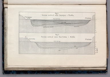
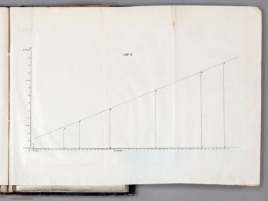


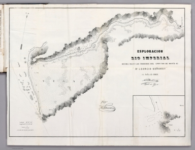


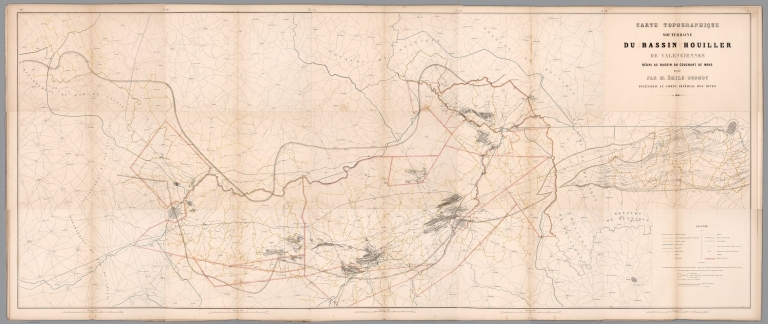
![Covers: سويش بوغازى واطرافلريند خريطه سى [Süveyş boğazı ve etraflarinde harita-sı / Map of the Suez Canal and its Surroundings]](https://www.davidrumsey.com/rumsey/Size2/RUMSEY~8~1/185/10599001.jpg)
![سويش بوغازى واطرافلريند خريطه سى [Süveyş boğazı ve etraflarinde harita-sı / Map of the Suez Canal and its Surroundings]](https://www.davidrumsey.com/rumsey/Size2/RUMSEY~8~1/185/10599002.jpg)