|
Author
[Power, James B., Asher & Adams]
Full Title
Power & Thornton's civil & congressional township map of the state of Minnesota : giving the names & boundaries of organized townships, location of cities, villages, post offices, railroads and main traveled roads.
List No
15887.000
Author
Schwegler & fils
Full Title
Panorama du Pilate prise sur l' Esel, 6532' au dessus de la mer. [Panorama of Pilate taken on the Esel, 6532' above the sea.]
List No
15719.001
Author
Schwegler & fils
Full Title
(C0vers to)Panorama du Pilate prise sur l' Esel, 6532' au dessus de la mer. [Panorama of Pilate taken on the Esel, 6532' above the sea.]
List No
15719.002
Author
Gormaz, Francisco Vidal, 1837-1907
Full Title
(Title Page to) Esploracion hidrográfica de la costa i rios de la Araucanía, comprendidos entre la Punta Cauten por el norte i la Punta Chanchan por el sur, hecha de órden del Supremo Gobierno, por el Teniente 1o. de Marina, don Francisco Vidal Gormaz. Imprenta Nacional, Calle de la Moneda, Núm. 46. 1867.
List No
14329.003
Note
Title page to Esploracion hidrográfica de la costa i Ríos de la Araucanía. Title translates to: Hydrographic exploration of the coast and rivers of Araucanía. Includes imprint. With library stamp: Biblioteca de Francisco A. Lobos Santiago.
Author
Gormaz, Francisco Vidal, 1837-1907
Full Title
Plano de la Caleta y Rio Queule levantado de orden del Supremo Gobierno por el Teniente 1o. de Marina dn. Francisco Vidal Gormaz. en 1866 i 1867. Lit. Cadot I Brandt, Santiago. Publicado por Decreto Supremo. No. 1.
List No
14329.004
Note
Nautical chart of the Caleta [Agua Fresca Bay] and Río Queule, Chile, from 1866 to 1867. Shows cities, roads, topography, vegetation, drainage, shorelines, shoals, islands and soundings. Relief illustrated with hachures. Includes a legend, coordinate points, two bar scales, a scale statement and a compass rose with north oriented toward top of sheet. Descriptive note beneath title. Text begins: La sonda trazada en el Río i sobre la barra, espresa pies ingleses i ha sido tomada en los momentos de baja marea [= The probe traced in the River and on the bar, expresed in English feet and taken at times of low tide]. Black and white lithograph. Chart is 62 x 35 cm, on fold-out sheet 71 x 44 cm. In first section of atlas, Esploracion hidrográfica de la costa i Ríos de la Araucanía.
Author
Gormaz, Francisco Vidal, 1837-1907
Full Title
Plano del Rio Queule que comprende desde el punto a. del plano No. 1. hasta el punto donde fue esplorado. Levantado de orden del Supremo Gobierno por el Teniente 1o. de Marina dn. Francisco Vidal Gormaz. en 1866 i 1867. Lit. Cadot I Brandt, Santiago. Publicado por Decreto Supremo. No. 2.
List No
14329.005
Note
Nautical chart of the Río Queule, Chile, from 1866 to 1867. Shows cities, roads, topography, vegetation, drainage, shoreline and soundings. Relief illustrated with hachures. Includes coordinate points, two bar scales and a scale statement, as well arrows indicating the direction of water flow and a compass rose with north oriented toward top of sheet. Descriptive note beneath title. Text begins: El Río Voroa, afluente principal del Queule, es remanso, profundo i navegable por embarcaciones menores en toda la estencion que ha sido esplorado [= The Voroa River, the main tributary of the Queule, is a backwater, deep and navigable by smaller vessels throughout the estuary that has been explored.]. With inset chart: Los Boldos. Black and white lithograph. Chart is 64 x 37 cm, on fold-out sheet 71 x 44 cm. In first section of atlas, Esploracion hidrográfica de la costa i Ríos de la Araucanía.
Author
Gormaz, Francisco Vidal, 1837-1907
Full Title
Plano del Rio Tolten i plaza militar del mismo nombre. Levantado de orden del Supremo Gobierno por el Teniente 1o. de Marina dn. Francisco Vidal Gormaz. en 1866 i 1867. Publicado por Decreto Supremo.
List No
14329.006
Note
Nautical chart of the Río Tolten [Toltén River] and the military plaza of the same name, Chile, from 1866 to 1867. Shows cities, roads, topography, vegetation, drainage, shorelines, shoals, islands, anchorage and soundings. Relief illustrated with hachures. Includes a legend, coordinate points, two bar scales and a scale statement, as well arrows indicating the direction of water flow and a compass rose with north oriented toward top right of sheet. Descriptive note in bottom right corner. Text begins: La marea del Océano hincha las aguas del Río pero sin tornar el curso de éstas hácia adentro [= The tide of the ocean swells the waters of the river but without turning the course of these inwards]. Black and white lithograph. Chart is 33 x 49 cm, on fold-out sheet 40 x 54 cm. In first section of atlas, Esploracion hidrográfica de la costa i Ríos de la Araucanía.
Author
[Gormaz, Francisco Vidal, 1837-1907, Molinas, Francisco Javier, Castillo, Luis A.]
Full Title
Plano del Rio Cruces i sus afluentes, levantado de órden del Smo. Gno. durante los meses de Noviembre i Diciembre de 1867 i Enero, Febrero i Marzo de 1868, por La Comision Esploradora del Rio Valdivia, compuesta del Tte. 1o. Fco. Vidal Gormaz, Jefe de ella, i de los Ttes. 2os. Fco. Javier Molinas i Luis A. Castillo. Lita. Cadot I Brandt, Santiago.
List No
14329.007
Note
Nautical chart of the Río Cruces [Cruces River] and its tributaries, Chile, during November and December, 1867, as well as January, February and March, 1868. Shows cities, roads, vegetation, drainage, shorelines, shoals and islands. Includes latitudinal and longitudinal lines, two bar scales and a scale statement, as well a compass rose with north oriented toward top of sheet. Descriptive note beneath title. Text begins: Las lineas fuertes indican la parte esplorada por la Comision i las lineas auxiliares ó cortadas la prolongacion aparente de los Ríos [= The strong lines indicate the part explored by the Commission and the auxiliary or cut lines the apparent prolongation of the rivers]. Black and white lithograph. Chart is 37 x 48 cm, on fold-out sheet 49 x 52 cm. In first section of atlas, Esploracion hidrográfica de la costa i Ríos de la Araucanía.
Author
Keeler, William J.
Full Title
(Covers to) National Map Of The Territory Of The United States From The Mississippi River To The Pacific Ocean. Made by the authority of the Hon. O.H. Browning Secretary of the Interior. In the Office of the Indian Bureau Chiefly For Government Purposes under the direction of the Hon. N.G. Taylor Commisr. of Indian affairs & Hon. Chas. E. Mix Chief Clerk of the Indian Bureau; Compiled from authorized explorations of Pacific Rail Road Routes, Public Surveys, and other reliable data from the Departments from the Government at Washington, D.C., by W.J. Keeler, Civil Engineer. 1867. N. DuBois Draughtsman. J.F. Gedney, Lithographer, Engraver & Plate Printer, Washington, D.C. Entered ... 1867 by Wm. J. Keeler ... District of Columbia.
List No
4737.001
Author
Keeler, William J.
Full Title
National Map Of The Territory Of The United States From The Mississippi River To The Pacific Ocean. Made by the authority of the Hon. O.H. Browning Secretary of the Interior. In the Office of the Indian Bureau Chiefly For Government Purposes under the direction of the Hon. N.G. Taylor Commisr. of Indian affairs & Hon. Chas. E. Mix Chief Clerk of the Indian Bureau; Compiled from authorized explorations of Pacific Rail Road Routes, Public Surveys, and other reliable data from the Departments from the Government at Washington, D.C., by W.J. Keeler, Civil Engineer. 1867. N. DuBois Draughtsman. J.F. Gedney, Lithographer, Engraver & Plate Printer, Washington, D.C. Entered ... 1867 by Wm. J. Keeler ... District of Columbia.
List No
4737.002
Author
Keeler, William J.
Full Title
(Covers to) National Map Of The Territory Of The United States From The Mississippi River To The Pacific Ocean. Made by the authority of the Hon. O.H. Browning Secretary of the Interior. In the Office of the Indian Bureau Chiefly For Government Purposes under the direction of the Hon. N.G. Taylor Commisr. of Indian affairs & Hon. Chas. E. Mix Chief Clerk of the Indian Bureau; Compiled from authorized explorations of Pacific Rail Road Routes, Public Surveys, and other reliable data from the Departments from the Government at Washington, D.C., by W.J. Keeler, Civil Engineer. 1867. N. DuBois Draughtsman. J.F. Gedney, Lithographer, Engraver & Plate Printer, Washington, D.C. Entered ... 1867 by Wm. J. Keeler ... District of Columbia.
List No
0397.001
Author
Keeler, William J.
Full Title
National Map Of The Territory Of The United States From The Mississippi River To The Pacific Ocean. Made by the authority of the Hon. O.H. Browning Secretary of the Interior. In the Office of the Indian Bureau Chiefly For Government Purposes under the direction of the Hon. N.G. Taylor Commisr. of Indian affairs & Hon. Chas. E. Mix Chief Clerk of the Indian Bureau; Compiled from authorized explorations of Pacific Rail Road Routes, Public Surveys, and other reliable data from the Departments from the Government at Washington, D.C., by W.J. Keeler, Civil Engineer. 1867. N. DuBois Draughtsman. J.F. Gedney, Lithographer, Engraver & Plate Printer, Washington, D.C. Entered ... 1867 by Wm. J. Keeler ... District of Columbia.
List No
0397.002
Author
Keeler, William J.
Full Title
(Covers to) National Map Of The Territory Of The United States From The Mississippi River To The Pacific Ocean. Made by the authority of the Hon. O.H. Browning Secretary of the Interior. In the Office of the Indian Bureau Chiefly For Government Purposes under the direction of the Hon. N.G. Taylor Commisr. of Indian affairs & Hon. Chas. E. Mix Chief Clerk of the Indian Bureau; Compiled from authorized explorations of Pacific Rail Road Routes, Public Surveys, and other reliable data from the Departments from the Government at Washington, D.C., by W.J. Keeler, Civil Engineer. 1867. N. DuBois Draughtsman. J.F. Gedney, Lithographer, Engraver & Plate Printer, Washington, D.C. Entered ... 1867 by Wm. J. Keeler ... District of Columbia.
List No
4694.001
Author
Keeler, William J.
Full Title
National Map Of The Territory Of The United States From The Mississippi River To The Pacific Ocean. Made by the authority of the Hon. O.H. Browning Secretary of the Interior. In the Office of the Indian Bureau Chiefly For Government Purposes under the direction of the Hon. N.G. Taylor Commisr. of Indian affairs & Hon. Chas. E. Mix Chief Clerk of the Indian Bureau; Compiled from authorized explorations of Pacific Rail Road Routes, Public Surveys, and other reliable data from the Departments from the Government at Washington, D.C., by W.J. Keeler, Civil Engineer. 1867. N. DuBois Draughtsman. J.F. Gedney, Lithographer, Engraver & Plate Printer, Washington, D.C. Entered ... 1867 by Wm. J. Keeler ... District of Columbia.
List No
4694.002
Author
Keeler, William J.
Full Title
(Title page to) (Covers to) Notes To Accompany Keeler's Map of the U.S. Territory, From The Mississippi River To The Pacific Ocean, Containing Authentic Information Connected With The Territories, And The Different Railroad Routes To The Pacific Ocean.
List No
4695.001
Author
Keeler, William J.
Full Title
(Composite text to) Notes To Accompany Keeler's Map of the U.S. Territory, From The Mississippi River To The Pacific Ocean, Containing Authentic Information Connected With The Territories, And The Different Railroad Routes To The Pacific Ocean.
List No
4695.002
Author
McMillan, J. & A.
Full Title
(Covers to) McMillan's Map Of New Brunswick 1867. Drawn by Chas. C. Gregory, Civil Engineer. Engraved by George Philip & Son, Liverpool & London. (with 2 inset maps).
List No
5068.001
Author
McMillan, J. & A.
Full Title
McMillan's Map Of New Brunswick 1867. Drawn by Chas. C. Gregory, Civil Engineer. Engraved by George Philip & Son, Liverpool & London. (with 2 inset maps).
List No
5068.002
Author
[Dormoy, Émile, Administration des Mines]
Full Title
(Section Title Page to) Carte topographie souterraine du Bassin Houiller de Valenciennes réuni au bassin du Couchant de Mons dressée par M. Émile Dormoy, Ingénieur au Corps Impérial des Mines, 1867.
List No
14382.009
Note
Section title page to Topographie souterraine du Bassin Houiller de Valenciennes. Includes imprint. Title translates to: Underground topography map of the of Valenciennes Coal Basin, joined to the "Couchant de Mons".
Author
[Survey of India, Montgomerie, T. G., Walker, J. & C.]
Full Title
Sheet 28 Indian Atlas (Kashmir) (Map of Himalayas)
List No
15198.000
Author
Harembert, Armand
Full Title
Nouvelle organographie du crane humain, ou la Cephalometrie. Phrenologie simplifiee, rectifiee appliquee a Education par Armand Harembert. A Paris.
List No
13103.002
Note
New educational view of the human skulls, measured by the shape and size of the cranium as a supposed indication of character and mental abilities. Printed on one sheet, 68x52.5, dissected into 9 sections folded into 23x18, with label pasted on verso. Includes decorative border, descriptive text and references to each character.
Author
Lallemand
Full Title
Nouveau Paris fortifié 1867 : plan garanti complet, ou, le guide dans Paris.
List No
10188.001
Note
Views of important buildings and monuments shown at their sites on the plan. Surrounding wall and boundaries of arrondissements traced in color. Plan divided into 319 numbered squares, to which alphabetical index of streets etc. is keyed. The folded plan is mounted on pasteboard cover. On the cover is an etching of Panthéon with Lallemand's address and title: Nouveau plan de Paris, ou, Guide des étrangers.
Author
Belloguet, Andre
Full Title
L’Europe Comique, par A. Belloguet, Cocasserie dediée à la Jeunesse.
List No
10147.001
Author
Belloguet, Andre
Full Title
L’Europe Comique, par A. Belloguet, Cocasserie dediée à la Jeunesse.
List No
10147.002
Note
Shows the individual parts to the puzzle.
Author
Kiepert, Heinrich, 1818-1899
Full Title
Erdkarte in Mercators Projection mit Bezeichnung der Meeresstromungen. Beriechtigt 1867. Situation u. Schrift gest. von W. Jaeck.Terrain gestochen von W. Bembe. (to accompany) H. Kiepert's Neuer Handatlas No. 1. Berlin BEI Dietrich Reimer.
List No
11693.008
Note
Double page hand colored in outline map. Showing Ocean Currents and Wind, centered on the Pacific basin, the map covers the entire world. Includes legend. Relief shown by hachures. Prime meridians are Ferro and Paris.
Author
[United States Bureau of Topographical Engineers, Dougal, W.H.]
Full Title
Old Territory and Military Department of New Mexico : compiled in the Bureau of Topogl. Engrs. of the War Dept. chiefly for military purposes. Under the authority of the Secretary of War 1850. Partially revised and corrected to 1867. Engraved by W. H. Dougal.
List No
11231.000
Note
Uncolored map, published prior to and revised after the Civil War. List of Authorities identifies 19 maps created by explorers of the region published between 1843 and 1858. Shows boundaries, principal travel routes, trails, mail routes, cities and villages, rivers and creeks. Includes list of Principal latitudes & longitudes astronomically determined. Includes notes.
Author
U.S. War Department
Full Title
(Covers to) Engineer Bureau, War Department. Map Of The States Of Kansas And Texas And Indian Territory, With Parts Of The Territories Of Colorado And New Mexico. From the most recent official surveys and explorations and other authentic information. 1867. J. Bien, Lith. 24 Vesey St. N.Y.
List No
2320A
Author
U.S. War Department
Full Title
Engineer Bureau, War Department. Map Of The States Of Kansas And Texas And Indian Territory, With Parts Of The Territories Of Colorado And New Mexico. From the most recent official surveys and explorations and other authentic information. 1867. J. Bien, Lith. 24 Vesey St. N.Y.
List No
2320.001
Note
1st edition. Not in Streeter, Phillips, Wheat. Map shows routes of important reconnaissances, Indian trails, roads, railroads in operation, projected railroads, army routes, Indian lands and reservations. One of the earliest detailed Army surveys of the area. The map was printed in two sheets, a north sheet and a south sheet. The north sheet appears in the Atlas to Accompany the Official Records of the Union and Confederate Armies as Plate CXIX, with the same title as this map, but with the title placed in the upper right corner of the north sheet. We also have the North sheet without title, dated c1875, with much additional information on new routes, railroads, etc. This map is signed by William E. Merrill, Maj. Engrs., and dated August 10, 1867. Merrill also signed our copy of the Warren Map of the U.S., 1867, with a signature date of August 26, 1867 Merrill later made maps of Kansas (See Karrow). Graff misspells Merrill's name, as does Streeter (his signature is hard to read). Dissected into 48 sections and mounted on linen. Map folds into two dark green cloth end boards 22.5x13.5 with paper label reading "Kansas, Texas, And Indian Territory, With Parts Of Colorado And New Mexico. Engineer Bureau, W.D. Prepared for Issue in Engineer Office, M.D. Mo. All Person Into Whose Hands The Map Falls Are Particularly Requested To Send All Corrections And Additions To The Chief Engineer, Mil. Div. Of The Mo., St. Louis." With hand painted color.
Author
[Alaskan Boundary Tribunal, U.S. Coast Survey]
Full Title
(Facsimile) North Western America Showing the Territory Ceded by Russia to the United States (portion) Compiled for the Department of State at the U.S. Coast Survey Office, B. Peirce, Supt. 1867. Alaskan Boundary Tribunal, 1903. 24. Photo. Lith. by A. Hoen & Co. Baltimore, MD.
List No
0009.067
Note
Tinted. Relief shown by hachures.
Author
[Alaskan Boundary Tribunal, Scott, Robert N.]
Full Title
(Facsimile) Sketch Map of Portland Channel and Vicinity Enclosure "C" (portion). In the Report of Lieutenant Colonel Robert N. Scott, U.S.A., November 12, 1867. Alaskan Boundary Tribunal, 1903. 31. Andrew B. Graham. Photo-Litho. Washington.D.C.
List No
0009.074
Author
Beers, Frederick W.
Full Title
(Covers to) Atlas Of New York And Vicinity From actual Surveys by and under the direction of F.W. Beers, assisted by Geo. E. Warner & others. Published By F.W. Beers, A.D. Ellis & G.G. Soule. Assistants F.S. Fulmer & Others. 95 Maiden Lane, New York. 1867. Entered ... 1867 by Beers, Ellis & Soule ... New York. Engd. by Worley & Bracher, 320 Chestnut St. Philada. Printed by James McGuigan, Cor. 3d & Dock Sts. Phila.
List No
0063.001
Note
Bound in leather brown cloth covered boards with "Atlas of New York and Vicinity. Beers, Ellis & Soule" stamped in gilt. Blind stamped on back cover.
Author
Beers, Frederick W.
Full Title
(Title Page) Atlas Of New York And Vicinity From actual Surveys by and under the direction of F.W. Beers, assisted by Geo. E. Warner & others. Published By F.W. Beers, A.D. Ellis & G.G. Soule. Assistants F.S. Fulmer & Others. 95 Maiden Lane, New York. 1867. Entered ... 1867 by Beers, Ellis & Soule ... New York. Engd. by Worley & Bracher, 320 Chestnut St. Philada. Printed by James McGuigan, Cor. 3d & Dock Sts. Phila.
List No
0063.002
Author
Beers, Frederick W.
Full Title
Table of Contents.
List No
0063.003
Author
Beers, Frederick W.
Full Title
(Text Page) Table of Air-Line Distances.
List No
0063.004
Author
Beers, Frederick W.
Full Title
Map of New York and Vicinity Accompanying Atlas of New York and Vicinity, Published by Beers, Ellis & Soule, 95 Maiden Lane, New York.
List No
0063.005
Author
Beers, Frederick W.
Full Title
Plan of New York and Brooklyn.
List No
0063.006
Author
Beers, Frederick W.
Full Title
Plans of Westchester, West Farms, Morrisania, Westchester Co. and Part of New York County.
List No
0063.007
Author
Beers, Frederick W.
Full Title
Town of Yonkers, Westchester Co., N.Y.
List No
0063.008
Author
Beers, Frederick W.
Full Title
Plan of Yonkers, Town of Yonkers, Westchester Co. N.Y.
List No
0063.009
Author
Beers, Frederick W.
Full Title
Plan of East Chester, Pelham and New Rochelle, Westchester Co., N.Y.
List No
0063.010
Author
Beers, Frederick W.
Full Title
Greenburgh, Westchester Co., N.Y.
List No
0063.011
Author
Beers, Frederick W.
Full Title
Plan of Beckmantown, Tarrytown and Irving, West Chester Co. N.Y.
List No
0063.012
Author
Beers, Frederick W.
Full Title
Mamaroneck, Scarsdale, White Plains, Harrison & Rye, Westchester Co., N.Y.
List No
0063.013
Author
Beers, Frederick W.
Full Title
White Plains, Westchester Co. N.Y.
List No
0063.014
Author
Beers, Frederick W.
Full Title
Town of Ossining, Town of Mt. Pleasant, Westchester Co., N.Y. (inset) Pleasantville Station.
List No
0063.015
Author
Beers, Frederick W.
Full Title
Singsing (Sparta), Town of Ossining, Westchester Co. N.Y.
List No
0063.016
Author
Beers, Frederick W.
Full Title
Town of North Castle, Westchester Co., N.Y. (insets) Armonk. Kensico.
List No
0063.017
Author
Beers, Frederick W.
Full Title
Town of Newcastle, Westchester Co., N.Y. (insets) Newcastle. Chappaqua.
List No
0063.018
Author
Beers, Frederick W.
Full Title
Town of Bedford, Westchester Co., N.Y.
List No
0063.019
Author
Beers, Frederick W.
Full Title
Town of Poundridge, Westchester Co., N.Y.
List No
0063.020
Author
Beers, Frederick W.
Full Title
Town of Lewisboro, Westchester Co., N.Y. (insets) Goldens Bridge. Cross River. South Salem.
List No
0063.021
Author
Beers, Frederick W.
Full Title
Town of Cortlandt, Westchester Co., N.Y.
List No
0063.022
Author
Beers, Frederick W.
Full Title
Plan of Peekskill, Westchester Co. N.Y. (inset) Courtland Cemetery.
List No
0063.023
Author
Beers, Frederick W.
Full Title
Town of Yorktown, Westchester Co., N.Y. (insets) Jefferson Valley. Shrub Oak.
List No
0063.024
Author
Beers, Frederick W.
Full Title
Town of Somers, Westchester Co., N.Y. Town of North Salem, Westchester Co., N.Y.
List No
0063.025
Author
Beers, Frederick W.
Full Title
(Town of) Putnam Valley and Philipstown. (inset) Oregon (New York).
List No
0063.026
Author
Beers, Frederick W.
Full Title
Cold Spring, Nelsonville, Westchester Co., N.Y.
List No
0063.027
Author
Beers, Frederick W.
Full Title
Town of Carmel, Winchester Co. N.Y.
List No
0063.028
Author
Beers, Frederick W.
Full Title
Carmel. Towners Station. South East Centre. Mill Town.
List No
0063.029
Author
Beers, Frederick W.
Full Title
Town of South East, Putnam Co., N.Y.
List No
0063.030
Author
Beers, Frederick W.
Full Title
Brewsters Station (Brewster). Patterson.
List No
0063.031
Author
Beers, Frederick W.
Full Title
Town of Patterson, Putnam Co., N.Y.
List No
0063.032
Author
Beers, Frederick W.
Full Title
Town of Kent, Putnam Co., N.Y.
List No
0063.033
Author
Beers, Frederick W.
Full Title
Plan of Dutchess Co. N.Y.
List No
0063.034
Note
Fold-out map.
Author
Beers, Frederick W.
Full Title
Fishkill, Dutchess Co. N.Y. Hughsonville. Carthage Landing (Chelsea). New Hackensack. Glenham.
List No
0063.035
Note
Fold-out map.
Author
Beers, Frederick W.
Full Title
Fishkill on the Hudson (Beacon) ... Dutchess Co. N.Y., Matteawan.
List No
0063.036
Note
Fold-out map.
Author
Beers, Frederick W.
Full Title
Fishkill ... Dutchess Co. N.Y. The Fishkill Rural Cemetery.
List No
0063.037
Author
Beers, Frederick W.
Full Title
Channingville, Dutchess Co. N.Y., Wappinger's Falls.
List No
0063.038
Note
Map actually entitled "Town of Channingville..." but it should read "Channingville" since it is a map of the village not a Township map in the sense that the word "Town" is used in this volume.
Author
Beers, Frederick W.
Full Title
Town of East Fishkill. (insets) Johnsville. East Fishkill. Stormville.
List No
0063.039
Author
Beers, Frederick W.
Full Title
Town of Beekman, Dutchess Co., N.Y. (insets) Beekman. Poughquag. Green Haven.
List No
0063.040
Author
Beers, Frederick W.
Full Title
Town of Pawling, Dutchess Co. N.Y.
List No
0063.041
Author
Beers, Frederick W.
Full Title
Town of Poughkeepsie, Dutchess Co. N.Y. (inset) New Hamburgh.
List No
0063.042
Author
Beers, Frederick W.
Full Title
Plan of the City of Poughkeepsie.
List No
0063.043
Author
Beers, Frederick W.
Full Title
Town of Lagrange, Dutchess Co. N.Y. (insets) Washington Hollow. Salt Point.
List No
0063.044
Author
Beers, Frederick W.
Full Title
Unionvale, Dutchess Co. N.Y. (inset) Verbank.
List No
0063.045
Author
Beers, Frederick W.
Full Title
Town of Dover, Dutchess Co. N.Y.
List No
0063.046
Author
Beers, Frederick W.
Full Title
Dover Plains. South Dover. Pawling Station.
List No
0063.047
Author
Beers, Frederick W.
Full Title
(View) Residence of Wm. H. Drew. Lake Farm, Residence of John V. Storm. R.K. Sneden, Del. Heliographic Eng. Co. 135 W. 25th St. N.Y.
List No
0063.048
Author
Beers, Frederick W.
Full Title
(View) Old Dutch Church at Fishkill. Teller's Villa, Residence of Hon. Isaac Teller. Tioronda Free School, Built by General Joseph Howland, 1864. R.K. Sneden, Del. Heliographic Eng. Co. 135 W. 25th St. N.Y.
List No
0063.049
Author
Beers, Frederick W.
Full Title
(View) Residence of A.S. Doane. N.L. Thompson's, Lake Mahopac. The Gregory House, Lake Mahopac. R.K. Sneden, Del. Heliographic Eng. Co. 135 W. 25th St. N.Y.
List No
0063.050
Author
Beers, Frederick W.
Full Title
(View) Property of F.A. Halstead. The Halsted Homestead. Inland Vale, Residence of J.S. Libby. R.K. Sneden, Del. Heliographic Eng. Co. 135 W. 25th St. N.Y.
List No
0063.051
Author
Beers, Frederick W.
Full Title
(View) Old Dutch Church, "Sleepy Hollow." Residence of A.B. Baylis, Esqr. "Sunny Side," Former Residence of Washington Irving. Photograph by Rockwood & Co. R.K. Sheden, Del. Heliographic Engr. Co. N.Y.
List No
0063.052
Author
Beers, Frederick W.
Full Title
(Covers to) Atlas Of New York And Vicinity From actual Surveys by and under the direction of F.W. Beers, assisted by Geo. E. Warner & others. Published By F.W. Beers, A.D. Ellis & G.G. Soule. Assistants F.S. Fulmer & Others. 95 Maiden Lane, New York. 1867. Entered ... 1867 by Beers, Ellis & Soule ... New York. Engd. by Worley & Bracher, 320 Chestnut St. Philada. Printed by James McGuigan, Cor. 3d & Dock Sts. Phila.
List No
0064.001
Note
Bound in quarter leather brown cloth covered boards with "Atlas of New York and Vicinity. Beers, Ellis & Soule" stamped in gilt.
Author
Beers, Frederick W.
Full Title
(Title Page) Atlas Of New York And Vicinity From actual Surveys by and under the direction of F.W. Beers, assisted by Geo. E. Warner & others. Published By F.W. Beers, A.D. Ellis & G.G. Soule. Assistants F.S. Fulmer & Others. 95 Maiden Lane, New York. 1867. Entered ... 1867 by Beers, Ellis & Soule ... New York. Engd. by Worley & Bracher, 320 Chestnut St. Philada. Printed by James McGuigan, Cor. 3d & Dock Sts. Phila.
List No
0064.002
Note
This is the McCorkle #2 issue - first Westchester County, 36 maps, smallest number of maps among the six issues. Full color. Most maps include local business directories.
Author
Beers, Frederick W.
Full Title
Table of Contents.
List No
0064.003
Author
Beers, Frederick W.
Full Title
(Text Page) Table of Air-Line Distances.
List No
0064.004
Author
Beers, Frederick W.
Full Title
Map of New York and Vicinity Accompanying Atlas of New York and Vicinity, Published by Beers, Ellis & Soule, 95 Maiden Lane, New York.
List No
0064.005
Note
Fold-out map.
Author
Beers, Frederick W.
Full Title
Plan of New York and Brooklyn.
List No
0064.006
Author
Beers, Frederick W.
Full Title
Plans of Westchester, West Farms, Morrisania, Westchester Co. and Part of New York County.
List No
0064.007
Author
Beers, Frederick W.
Full Title
Town of Yonkers, Westchester Co., N.Y.
List No
0064.008
Author
Beers, Frederick W.
Full Title
Plan of Yonkers, Town of Yonkers, Westchester Co. N.Y.
List No
0064.009
Author
Beers, Frederick W.
Full Title
Plan of East Chester, Pelham and New Rochelle, Westchester Co., N.Y.
List No
0064.010
Author
Beers, Frederick W.
Full Title
Plan of the Borough of New Rochelle, Westchester Co. N.Y.
List No
0064.011
Author
Beers, Frederick W.
Full Title
Town of Greenburgh, Westchester Co., N.Y.
List No
0064.012
Author
Beers, Frederick W.
Full Title
Plan of Beekmantown, Tarrytown and Irving, West Chester Co. N.Y.
List No
0064.013
Author
Beers, Frederick W.
Full Title
Mamaroneck, Scarsdale, White Plains, Harrison & Rye, Westchester Co., N.Y.
List No
0064.014
Author
Beers, Frederick W.
Full Title
Mamaroneck, Rye Neck.
List No
0064.015
Author
Beers, Frederick W.
Full Title
White Plains, Westchester Co. N.Y.
List No
0064.016
Author
Beers, Frederick W.
Full Title
Port Chester, Westchester Co., N.Y.
List No
0064.017
Note
Fold-out map.
Author
Beers, Frederick W.
Full Title
Town of Mt. Pleasant, Westchester Co. N.Y. (insets) Pleasantville. Pleasantville Station.
List No
0064.018
Author
Beers, Frederick W.
Full Title
Town of North Castle, Westchester Co., N.Y. (insets) Armonk. Kensico.
List No
0064.019
Author
Beers, Frederick W.
Full Title
Town of Ossining, Westchester Co., N.Y. Sparta.
List No
0064.020
Author
Beers, Frederick W.
Full Title
Singsing (Sparta), Town of Ossining, Westchester Co. N.Y.
List No
0064.021
Author
Beers, Frederick W.
Full Title
Town of Newcastle, Westchester Co., N.Y. (insets) Newcastle. Chappaqua.
List No
0064.022
Author
Beers, Frederick W.
Full Title
Mount Kisco. Katonah, Whitlockville. Bedford. Bedford Station (Bedford Hills).
List No
0064.023
Author
Beers, Frederick W.
Full Title
Town of Bedford, Westchester Co. N.Y.
List No
0064.024
Author
Beers, Frederick W.
Full Title
Town of Poundridge, Westchester Co., N.Y.
List No
0064.025
Author
Beers, Frederick W.
Full Title
Town of Lewisboro, Westchester Co., N.Y. (insets) Goldens Bridge. Cross River. South Salem.
List No
0064.026
Author
Beers, Frederick W.
Full Title
Town of Cortlandt, Westchester Co., N.Y. (inset) Courtlandtville.
List No
0064.027
Author
Beers, Frederick W.
Full Title
Plan of Peekskill, Westchester Co. N.Y. (inset) Courtlandt Cemetery.
List No
0064.028
Note
Fold-out map.
Author
Beers, Frederick W.
Full Title
Verplanck, Town of Cortlandt, West Chester Co. N.Y. Crugers. Croton Landing.
List No
0064.029
Author
Beers, Frederick W.
Full Title
Town of Yorktown, Westchester Co., N.Y. (insets) Jefferson Valley. Shrub Oak.
List No
0064.030
Author
Beers, Frederick W.
Full Title
Town of Somers, Westchester Co., N.Y. (inset) Somers.
List No
0064.031
Author
Beers, Frederick W.
Full Title
Town of North Salem, Westchester Co., N.Y. (insets) Croton Falls. North Salem. Purdy Station. Salem Centre.
List No
0064.032
Author
Beers, Frederick W.
Full Title
Putnam Valley and Philipstown. (inset) Oregon (New York).
List No
0064.033
Note
Fold-out map.
Author
Beers, Frederick W.
Full Title
Cold Spring, Nelsonville, Westchester Co., N.Y.
List No
0064.034
Note
Fold-out map.
Author
Beers, Frederick W.
Full Title
Town of Carmel, Winchester Co. N.Y.
List No
0064.035
Author
Beers, Frederick W.
Full Title
Carmel. Towners Station. South East Centre. Mill Town.
List No
0064.036
Author
Beers, Frederick W.
Full Title
Town of South East, Putnam Co., N.Y.
List No
0064.037
Author
Beers, Frederick W.
Full Title
Brewsters Station (Brewster). Patterson.
List No
0064.038
Author
Beers, Frederick W.
Full Title
Town of Patterson, Putnam Co., N.Y.
List No
0064.039
Author
Beers, Frederick W.
Full Title
Town of Kent, Putnam Co., N.Y.
List No
0064.040
Author
Beers, Frederick W.
Full Title
(View) Residence of A.S. Doane. N.L. Thompson's, Lake Mahopac. The Gregory House, Lake Mahopac. R.K. Sneden, Del. Heliographic Eng. Co. 135 W. 25th St. N.Y.
List No
0064.041
Author
Beers, Frederick W.
Full Title
(View) Residences of Oliver V. Todd. Residence of B. Travis. Reisig & Hexamers Barn "Ivy Hill". Residence of W.F. Bearns "Incleuberg".
List No
0064.042
Author
Beers, Frederick W.
Full Title
(View) Property of F.A. Halstead. The Halsted Homestead. Inland Vale, Residence of J.S. Libby. R.K. Sneden, Del. Heliographic Eng. Co. 135 W. 25th St. N.Y.
List No
0064.043
Author
Beers, Frederick W.
Full Title
(View) View of Brewsters'. From an India ink drawing by R.K. Sneden. Reprodued by yhe Heliographic Eng. Co.
List No
0064.044
Author
Beers, Frederick W.
Full Title
(View) Residence of Wm. H. Drew. Lake Farm, Residence of John V. Storm. R.K. Sneden, Del. Heliographic Eng. Co. 135 W. 25th St. N.Y.
List No
0064.045
Author
Beers, Frederick W.
Full Title
(View) Mount Vernon Valley, Residence of S.J. Powers. Borden Condensed Milk Factory. Residence of Danl. D. Chamberlain. R.K. Sneden, Del. Heliographic Eng. Co. 135 W. 25th St. N.Y.
List No
0064.046
Author
Beers, Frederick W.
Full Title
Old Dutch Church, "Sleepy Hollow." Residence of A.B. Baylis, Esqr. "Sunny Side," Former Residence of Washington Irving. Photograph by Rockwood & Co. R.K. Sheden, Del. Heliographic Engr. Co. N.Y.
List No
0064.047
Author
Colton, G.W. & C.B.
Full Title
(Covers to) Colton's Railroad & Township Map of the State of Ohio. Published By G.W. & C.B. Colton, No. 172 William St. New York. 1867. Entered ... 1851 by J.H. Colton ... New York.
List No
0157.001
Note
As with all issues of this map, the primary difference between editions is the rapid railroad growth in the state. Full color by township. Map is folded into dark brown cloth covers 14.5x9 with "Colton's Township Map Of The State Of Ohio G.W. & C.B. Colton & Co." in gilt. Prime meridians are Greenwich and Washington D.C.
Author
Colton, G.W. & C.B.
Full Title
Colton's Railroad & Township Map of the State of Ohio. Published By G.W. & C.B. Colton, No. 172 William St. New York. 1867. Entered ... 1851 by J.H. Colton ... New York.
List No
0157.002
Note
As with all issues of this map, the primary difference between editions is the rapid railroad growth in the state. Full color by township. Map is folded into dark brown cloth covers 14.5x9 with "Colton's Township Map Of The State Of Ohio G.W. & C.B. Colton & Co." in gilt. Prime meridians are Greenwich and Washington D.C.
Author
[Colton, G.W., Colton, C.B., Gray, O.W.]
Full Title
Minnesota. Entered ... 1867, by G.W. & C.B. Colton & Co.
List No
0312.040
Author
[Gray, Frank A., Gray, O.W.]
Full Title
Illinois. Entered ... 1867 by G.W. & C.B. Colton & Co. (inset) Plan of Cook County & Vicinity of Chicago.
List No
0312.044
Author
[Paullin, Charles O., Wright, John K.]
Full Title
Plate 32. Cartography 1492-1867. Clark Map, 1810. Chapin Map, 1839. Smith Map, 1843. Colton Map, 1867. (Facsimiles).
List No
0702.035
Author
[Stieler, Adolf, Petermann, A.]
Full Title
Stieler's Hand-Atlas ... No. 16/17. Daenemark mit Schleswig, Holstein, und Laeenburg. (insets) Island (Iceland). Kopenhagen (Copenhagen). Die Far-oer. Gronland.
List No
0960.027
Note
Different edition from previous map.
Author
Stieler, Adolf
Full Title
No. I. Karte von Deutschland den Konigr. der Niederlande dem Kgr. Belgien, der Schweiz und den angranzenden Landern, bis Paris, Lyon, Turin, Mailand, Venedig, Ofen, Konnigsberg, in XXV Blatt.
List No
0960.035
Note
This sheet is part of an incomplete set.
Author
Stieler, Adolf
Full Title
No. II. Karte von Deutschland den Konigr. der Niederlande dem Kgr. Belgien, der Schweiz und den angranzenden Landern, bis Paris, Lyon, Turin, Mailand, Venedig, Ofen, Konnigsberg, in XXV Blatt.
List No
0960.036
Note
This sheet is part of an incomplete set.
Author
Stieler, Adolf
Full Title
No. III. Karte von Deutschland den Konigr. der Niederlande dem Kgr. Belgien, der Schweiz und den angranzenden Landern, bis Paris, Lyon, Turin, Mailand, Venedig, Ofen, Konnigsberg, in XXV Blatt.
List No
0960.037
Note
This sheet is part of an incomplete set.
Author
Stieler, Adolf
Full Title
No. IV. Karte von Deutschland den Konigr. der Niederlande dem Kgr. Belgien, der Schweiz und den angranzenden Landern, bis Paris, Lyon, Turin, Mailand, Venedig, Ofen, Konnigsberg, in XXV Blatt.
List No
0960.038
Note
This sheet is part of an incomplete set.
Author
Stieler, Adolf
Full Title
No. V. Karte von Deutschland den Konigr. der Niederlande dem Kgr. Belgien, der Schweiz und den angranzenden Landern, bis Paris, Lyon, Turin, Mailand, Venedig, Ofen, Konnigsberg, in XXV Blatt.
List No
0960.039
Note
This sheet is part of an incomplete set.
Author
Stieler, Adolf
Full Title
No. VI. Karte von Deutschland den Konigr. der Niederlande dem Kgr. Belgien, der Schweiz und den angranzenden Landern, bis Paris, Lyon, Turin, Mailand, Venedig, Ofen, Konnigsberg, in XXV Blatt.
List No
0960.040
Note
This sheet is part of an incomplete set.
Author
Stieler, Adolf
Full Title
No. VII. Karte von Deutschland den Konigr. der Niederlande dem Kgr. Belgien, der Schweiz und den angranzenden Landern, bis Paris, Lyon, Turin, Mailand, Venedig, Ofen, Konnigsberg, in XXV Blatt.
List No
0960.041
Note
This sheet is part of an incomplete set.
Author
Stieler, Adolf
Full Title
No. VIII. Karte von Deutschland den Konigr. der Niederlande dem Kgr. Belgien, der Schweiz und den angranzenden Landern, bis Paris, Lyon, Turin, Mailand, Venedig, Ofen, Konnigsberg, in XXV Blatt.
List No
0960.042
Note
This sheet is part of an incomplete set.
Author
Stieler, Adolf
Full Title
No. X. Karte von Deutschland den Konigr. der Niederlande dem Kgr. Belgien, der Schweiz und den angranzenden Landern, bis Paris, Lyon, Turin, Mailand, Venedig, Ofen, Konnigsberg, in XXV Blatt.
List No
0960.043
Note
This sheet is part of an incomplete set.
Author
Stieler, Adolf
Full Title
No. XIII. Karte von Deutschland den Konigr. der Niederlande dem Kgr. Belgien, der Schweiz und den angranzenden Landern, bis Paris, Lyon, Turin, Mailand, Venedig, Ofen, Konnigsberg, in XXV Blatt.
List No
0960.044
Note
This sheet is part of an incomplete set.
Author
Stieler, Adolf
Full Title
No. XVIII. Karte von Deutschland den Konigr. der Niederlande dem Kgr. Belgien, der Schweiz und den angranzenden Landern, bis Paris, Lyon, Turin, Mailand, Venedig, Ofen, Konnigsberg, in XXV Blatt.
List No
0960.045
Note
This sheet is part of an incomplete set.
Author
Stieler, Adolf
Full Title
No. XIX. Karte von Deutschland den Konigr. der Niederlande dem Kgr. Belgien, der Schweiz und den angranzenden Landern, bis Paris, Lyon, Turin, Mailand, Venedig, Ofen, Konnigsberg, in XXV Blatt.
List No
0960.046
Note
This sheet is part of an incomplete set.
Author
Stieler, Adolf
Full Title
No. XXV. Karte von Deutschland den Konigr. der Niederlande dem Kgr. Belgien, der Schweiz und den angranzenden Landern, bis Paris, Lyon, Turin, Mailand, Venedig, Ofen, Konnigsberg, in XXV Blatt.
List No
0960.047
Note
This sheet is part of an incomplete set. Legend.
Author
Stieler, Adolf
Full Title
(Composite of) Karte von Deutschland den Konigr. der Niederlande dem Kgr. Belgien, der Schweiz und den angranzenden Landern, bis Paris, Lyon, Turin, Mailand, Venedig, Ofen, Konnigsberg, in XXV Blatt.
List No
0960.107
Note
Composite of an incomplete set.
Author
[Stieler, Adolf, Vogel, C.]
Full Title
Stieler's Hand-Atlas ... No. 27 & 28. Sachsen, Thuringen und Benachbarte Laender.
List No
0960.051
Note
Shows profile of mountains.
Author
[Stieler, Adolf, Vogel, C.]
Full Title
Stieler's Hand-Atlas ... No. 26. Der Osterreichische Kaiserstaat. (inset) Wien.
List No
0960.055
Author
[Stieler, Adolf, Petermann, A.]
Full Title
Stieler's Hand-Atlas ... No. 34a. Ober-und Mittel-Italien.
List No
0960.060
Author
[Stieler, Adolf, Petermann, A.]
Full Title
Stieler's Hand-Atlas ... No. 36. Russland und Skandinavien. (insets) Moskau und Umgebung. St. Petersburg und Umgebung.
List No
0960.064
Author
[Stieler, Adolf, Petermann, A.]
Full Title
Stieler's Hand-Atlas ... No. 37b: Ost-Europe, Nordost-Russland.
List No
0960.068
Author
[Stieler, Adolf, Petermann, A.]
Full Title
Stieler's Hand-Atlas ... No. 37c. Ost-Europa No. 3. Sud-Schweden, die Russichen Ostsee-Povinzen, Polen & West Russland.
List No
0960.070
Author
[Stieler, Adolf, Petermann, A.]
Full Title
Stieler's Hand-Atlas ... No. 37e. Ost-Europa No. 5. Sud-West-Russland & die Turkei.
List No
0960.072
Author
[Stieler, Adolf, Petermann, A.]
Full Title
Stieler's Hand-Atlas ... No. 38a. Ost-Europa No. 6. Sud-Russland & Kaukasien. (insets) Der Ararat. Tiflis.
List No
0960.073
Author
[Stieler, Adolf, Petermann, A.]
Full Title
Stieler's Hand-Atlas ... No. 38c. Griechenland und der Griechisch-Turkische Archipel. (insets) Santorin. Syra. Athens.
List No
0960.075
Author
Stieler, Adolf
Full Title
Stieler's Hand-Atlas ... No. 38a. Ost-Europa No. 6. Sud-Russland & Kaukasien. (insets) Der Ararat. Tiflis.
List No
0960.076
Author
[Stieler, Adolf, Stulpnagel, F.v.]
Full Title
Stieler's Hand-Atlas ... No. 49a. Sud-Amerika.
List No
0960.089
Author
Taintor Brothers
Full Title
(Covers to) The City Of New York. A Complete Guide. With Descriptive Sketches Of Objects And Places Of Interest. With Map. Entered ... 1867, by Taintor Brothers & Co. ... New York. New York: Taintor Brothers, 678 Broadway. (with map) New Map Of The Great Metropolis, Including The Cities Of New York, Brooklyn, Jersey City, Hoboken, & Co., Published By Taintor Brothers, 758 Broadway.
List No
0973.001
Note
An Eighty three page guide book with map. Orange card board cover reads "Taintor's Route And City Guides. City Of New York. Taintor Brothers, 678 Broadway, New York." Full color.
Author
Taintor Brothers
Full Title
(Title Page to) The City Of New York. A Complete Guide. With Descriptive Sketches Of Objects And Places Of Interest. With Map. Entered ... 1867, by Taintor Brothers & Co. ... New York. New York: Taintor Brothers, 678 Broadway. (with map) New Map Of The Great Metropolis, Including The Cities Of New York, Brooklyn, Jersey City, Hoboken, & Co., Published By Taintor Brothers, 758 Broadway.
List No
0973.002
Note
An Eighty three page guide book with map. Orange card board cover reads "Taintor's Route And City Guides. City Of New York. Taintor Brothers, 678 Broadway, New York." Full color.
Author
Taintor Brothers
Full Title
New Map Of The Great Metropolis, Including The Cities Of New York, Brooklyn, Jersey City, Hoboken, & Co., Published By Taintor Brothers, 758 Broadway. (with 83 p. text) The City Of New York. A Complete Guide. With Descriptive Sketches Of Objects And Places Of Interest. With Map. Entered ... 1867, by Taintor Brothers & Co. ... New York. New York: Taintor Brothers, 678 Broadway.
List No
0973.003
Note
An Eighty three page guide book with map. Orange card board cover reads "Taintor's Route And City Guides. City Of New York. Taintor Brothers, 678 Broadway, New York." Full color.
Author
Taintor Brothers
Full Title
(Text Page to) The City Of New York. A Complete Guide. With Descriptive Sketches Of Objects And Places Of Interest. With Map. Entered ... 1867, by Taintor Brothers & Co. ... New York. New York: Taintor Brothers, 678 Broadway. (with map) New Map Of The Great Metropolis, Including The Cities Of New York, Brooklyn, Jersey City, Hoboken, & Co., Published By Taintor Brothers, 758 Broadway.
List No
0973.004
Note
An Eighty three page guide book with map. Orange card board cover reads "Taintor's Route And City Guides. City Of New York. Taintor Brothers, 678 Broadway, New York." Full color.
Author
Lallemand
Full Title
(Covers to) Nouveau Paris fortifié 1867 : plan garanti complet, ou, le guide dans Paris.
List No
10188.002
Note
Views of important buildings and monuments shown at their sites on the plan. Surrounding wall and boundaries of arrondissements traced in color. Plan divided into 319 numbered squares, to which alphabetical index of streets etc. is keyed. The folded plan is mounted on pasteboard cover. On the cover is an etching of Panthéon with Lallemand's address and title: Nouveau plan de Paris, ou, Guide des étrangers.
Author
Kongelige Danske Søkort-Arkiv
Full Title
Island -- Kaart over Pollen i Skutilsfjord, Isefjords dybet, Opmaalt far Skrueskonnerten Fylla Juni 1865
List No
10988.000
Author
Kiepert, Heinrich, 1818-1899
Full Title
Ostlicher Planiglob. Beriechtigt 1867. Situation u. Schrift gest. von W. Jaeck. 1856. Terrain gestochen von W. Bembe. (to accompany) H. Kiepert's Neuer Handatlas No. 2. Berlin BEI Dietrich Reimer.
List No
11693.009
Note
Double page circular hand colored in outline map of Eastern Hemisphere. Showing Ocean Currents and Wind. Includes legend. Relief shown by hachures.
Author
Kiepert, Heinrich, 1818-1899
Full Title
Westlicher Planiglob. Beriechtigt 1867. Situation u. Schrift gest. von W. Jaeck.Terrain gestochen von W. Bembe. 1856. (to accompany) H. Kiepert's Neuer Handatlas No. 3. Berlin BEI Dietrich Reimer.
List No
11693.010
Note
Double page circular hand colored in outline map of Western Hemisphere. Showing Ocean Currents and Wind. Includes legend. Relief shown by hachures.
Author
Kiepert, Heinrich, 1818-1899
Full Title
Brandenburg, Schlesien, Posen. Beriechtigt 1867. Situation und Schrift gestochen v. Friedr. Meier in Nurnberg 1860. Terrain gestochen von W. Bemebe. (to accompany) H. Kiepert's Neuer Handatlas No. 10. Berlin BEI Dietrich Reimer.
List No
11693.017
Note
Double page hand colored in outline map. Color coded by administrative boundaries. Includes legend and abbreviation. Relief shown by hachures. Prime meridians are Ferro and Paris.
Author
Kiepert, Heinrich, 1818-1899
Full Title
Pommern und Preussen. Beriechtigt 1867. Situation von Otto v. Eyb, in Munchen u. Fr. Schrift gestochen v. Fr. Meier in Nurnberg 1858. (to accompany) H. Kiepert's Neuer Handatlas No. 11. Berlin BEI Dietrich Reimer.
List No
11693.018
Note
Double page hand colored in outline map. Color coded by administrative boundaries. Includes legend. Relief shown by hachures. Prime meridians are Ferro and Paris.
Author
Kiepert, Heinrich, 1818-1899
Full Title
Frankreich. Beriechtigt 1867. Schrift gestochen von K. Dekinder. Terrain gestochen von C. Seitz. (to accompany) H. Kiepert's Neuer Handatlas No. 19. Berlin BEI Dietrich Reimer. (insets) Das Seine Departement oder Umgebungen von Paris. (with) Corsica (Corse).
List No
11693.027
Note
Double page hand colored in outline map. Color coded by administrative boundaries. Includes legend and abbreviations. Relief shown by hachures. Prime meridians are Ferro and Paris.
Author
Kiepert, Heinrich, 1818-1899
Full Title
Russland. Neue Bearbeitung.1867. Stich. und Druck d. Geogr. lith. Inst. v. Sulzer, Berlin. (to accompany) H. Kiepert's Neuer Handatlas No. 24. Berlin BEI Dietrich Reimer.
List No
11693.034
Note
Double page hand colored in outline map. Color coded by administrative boundaries. Includes legend and abbreviations. Relief shown by hachures. Prime meridians are Ferro and Paris.
Author
Kiepert, Heinrich, 1818-1899
Full Title
Griechenland. Bearbeitet 1867. Stich. und Druck d. Geogr. lith. Inst. v. Sulzer, Berlin. (to accompany) H. Kiepert's Neuer Handatlas No. 25a. Berlin BEI Dietrich Reimer. (inset) Umgebungen von Athen und seinen Hafen.
List No
11693.036
Note
Double page hand colored in outline map. Color coded by political and administrative boundaries. Includes legend and abbreviations. Relief shown by hachures. Prime meridians are Ferro and Paris.
Author
Kiepert, Heinrich, 1818-1899
Full Title
Asiatische Turkei. Neue Bearbeitung 1867. Stich. und Druck d. Geogr. lith. Inst. v. Sulzer, Berlin. (to accompany) H. Kiepert's Neuer Handatlas No. 27. Berlin BEI Dietrich Reimer.
List No
11693.038
Note
Double page hand colored in outline map. Color coded by political and administrative boundaries. Includes legend and abbreviations. Relief shown by hachures. Prime meridians are Greenwich and Paris.
Author
Kiepert, Heinrich, 1818-1899
Full Title
Ostliches Nordamerica. Berichtgt 1867. Gestochen von G. Wirsing und O. Eyb in Munchen 1856. (to accompany) H. Kiepert's Neuer Handatlas No. 37. Berlin BEI Dietrich Reimer. (insets) Der Niagara. (with) Die nordostlichen Staten.
List No
11693.048
Note
Double page hand colored in outline map. Color coded by administrative boundaries. Includes legend and text. Relief shown by hachures. Prime meridians are Ferro, Greenwich and Paris.
Author
Kiepert, Heinrich, 1818-1899
Full Title
Westliches-Nordamerica. Berichtgt 1867. Gestochen v. C.L. Ohmann. Durck v. F. Barth. (to accompany) H. Kiepert's Neuer Handatlas No. 38. Berlin BEI Dietrich Reimer.
List No
11693.049
Note
Double page hand colored in outline map. Color coded by administrative boundaries. Includes legend and text. Relief shown by hachures. Prime meridians are Ferro, Greenwich and Paris.
Author
Kiepert, Heinrich, 1818-1899
Full Title
Sud-America. Neue Bearbeitung. Berichtgt 1867. Stich. v. J. Sulzer. Durck v. F. Barth. (to accompany) H. Kiepert's Neuer Handatlas No. 40. Berlin BEI Dietrich Reimer.
List No
11693.051
Note
Double page hand colored in outline map. Color coded by administrative boundaries. Includes legend and text. Relief shown by hachures. Prime meridians are Ferro, Greenwich and Paris.
Author
[Warren, G.K., U. S. Army. Corps of Engineers]
Full Title
Map Of Nebraska And Dakota, And Portions Of The States And Territories Bordering Thereon, Compiled By Bv't Maj. Gen. G.K. Warren, Maj. Engineers. March, 1867 ... Engineer Dep't U.S. Army. Bv't Maj. Gen. A.A. Humphreys, Chief Of Engineers.
List No
1173.000
Note
Later version of 1858 edition. Includes routes, surveys and reconnaissances indexed by dates and name of person in charge. Not in Wheat. Unfolded separate issue. In two sheets; without color. Relief shown by hachures.
Author
Harembert, Armand
Full Title
(Covers to) Nouvelle organographie du crane humain, ou la Cephalometrie. Phrenologie simplifiee, rectifiee appliquee a Education par Armand Harembert. A Paris.
List No
13103.001
Note
New educational view of the human skulls, measured by the shape and size of the cranium as a supposed indication of character and mental abilities. Printed on one sheet, 68x52.5, dissected into 9 sections folded into 23x18, with label pasted on verso. Includes decorative border, descriptive text and references to each character.
Author
France. Depot General de la Guerre
Full Title
Bayonne. Levee par les Officiers du Corps d'Etat major et publee par Depot de la Guerre en 1867. Gravee : le trait par Thuillier , la lettre par Hacq, le figuré du terrain par Dandeleux, les eaux par Chartier. Imp. par Lamercier et Cie. Paris. (to accompany) Carte de la France a l'echelle de 1 pour 320,000.
List No
13422.031
Note
Engraved map of Bayonne, and surrounding areas. Relief shown by hachures.
Author
Wyld, James
Full Title
Map of Australia, compiled from the nautical surveys, made by order of The Admiralty, and other authentic documents. By James Wyld, Geographer to the Queen. London: Published by James Wyld, Charing Cross East.
List No
13484.000
Author
Gormaz, Francisco Vidal, 1837-1907
Full Title
(Covers to) Apuntes sobre la costa de Chile.
List No
14329.001
Note
Covers to Esploracion hidrográfica de la costa i Ríos de la Araucanía. Bound in board with leather spine. Front and back covers decorated with black and blue marbled paper. Gilded spine title, which translates to: Notes on the coast of Chile.
Author
Gormaz, Francisco Vidal, 1837-1907
Full Title
(Text Page to) [Book plate] -- [Annotations].
List No
14329.002
Note
On left - verso of front cover to Esploracion hidrográfica de la costa i Ríos de la Araucanía. With book plate, which has author's name: Fco. Vidal Gormáz. On right - originally blank (unnumbered) page with handwritten annotations, in ink, providing a list of items numbered 1 through 8.
Author
Colton, G.W. & C.B.
Full Title
(Covers to) Colton's Map Of The County Of Westchester. Drawn, Engraved and Published by G.W. & C.B. Colton & Co. 172 William St. New York. 1867. Entered ... 1867 by G.W. & C.B Colton & Co. ... New York.
List No
1694.001
Note
1st edition. Shows the emerging suburbs in the southern part of the county, along with railroads and historic sites. Full color by township. Folded into dark brown cloth covers 14.5x9.5 with "Map Of Westchester County G.W. & C.B. Colton & Co." in gilt.
Author
Colton, G.W. & C.B.
Full Title
Colton's Map Of The County Of Westchester. Drawn, Engraved and Published by G.W. & C.B. Colton & Co. 172 William St. New York. 1867. Entered ... 1867 by G.W. & C.B Colton & Co. ... New York.
List No
1694.002
Note
1st edition. Shows the emerging suburbs in the southern part of the county, along with railroads and historic sites. Full color by township. Folded into dark brown cloth covers 14.5x9.5 with "Map Of Westchester County G.W. & C.B. Colton & Co." in gilt.
Author
Colton, G.W. & C.B.
Full Title
(Covers to) Map showing the Line of The New Haven, Middletown And Boston Railroad and its connections. Published by G.W. And C.B. Colton, & Co. 172 William St. New York. 1867. Entered ... 1867 by G.W. & C.B. Colton & Co ... New York.
List No
1695.001
Note
Shows all of New England, with the White Mountains drawn in. Also has a Table of Distances. Includes a small box below the title: "Maps of every description to accompany Reports Prospectuses etc. Drawn Engraved Printed & Colored at Coltons Geographical Establishment No. 172 William St. New York." This advertising box appears in many Colton maps from the mid 1860's to about 1875. Uncolored, except for blue and red railroad routes. Map is folded into dark brown cloth covers 14.5x9 with "Colton's Map Showing The New-Haven, Middletown, And Boston Railroad, And its Connections. G.W. & C.B. Colton & Co." stamped in gilt. Prime meridian is Washington D.C.
Author
Colton, G.W. & C.B.
Full Title
Map showing the Line of The New Haven, Middletown And Boston Railroad and its connections. Published by G.W. And C.B. Colton, & Co. 172 William St. New York. 1867. Entered ... 1867 by G.W. & C.B. Colton & Co ... New York.
List No
1695.002
Note
Shows all of New England, with the White Mountains drawn in. Also has a Table of Distances. Includes a small box below the title: "Maps of every description to accompany Reports Prospectuses etc. Drawn Engraved Printed & Colored at Coltons Geographical Establishment No. 172 William St. New York." This advertising box appears in many Colton maps from the mid 1860's to about 1875. Uncolored, except for blue and red railroad routes. Map is folded into dark brown cloth covers 14.5x9 with "Colton's Map Showing The New-Haven, Middletown, And Boston Railroad, And its Connections. G.W. & C.B. Colton & Co." stamped in gilt. Prime meridian is Washington D.C.
Author
Fay, T.S.
Full Title
(Covers to) Atlas To Fay's Great Outline Of Geography For High Schools And Families, With A Text-Book. New York: G.P. Putnam's Sons, 4th Avenue and 23d Street.
List No
1832.001
Note
Bound in quarter leather tan paper covered boards with title printed in black.
Author
Fay, T.S.
Full Title
(Title Page) Atlas To Fay's Great Outline Of Geography For High Schools And Families, With A Text-Book. New York: G.P. Putnam's Sons, 4th Avenue and 23d Street.
List No
1832.002
Note
Date estimated.
Author
Fay, T.S.
Full Title
Plate I. (Twelve Perspectives on the Earth in Orbit and Rotation). Drawn by B. Hassenstein, Cartographer. Berlin. Engraved on Stone by Leopold Kraatz. Berlin.
List No
1832.003
Note
Date estimated.
Author
Fay, T.S.
Full Title
Plate II. Natural Land - & Water- Divisions of the World. Drawn by B. Hassenstein, Cartographer. Berlin. Engraved on Stone by Leopold Kraatz. Berlin.
List No
1832.004
Note
Date estimated. Relief shown by hachures. In hemispheres. Includes graphic representation of rivers and mountains.
Author
Fay, T.S.
Full Title
Plate III. Principal Countries of the World. Drawn by B. Hassenstein, Cartographer. Berlin. Engraved on Stone by Leopold Kraatz. Berlin.
List No
1832.005
Note
Date estimated. Relief shown by hachures.
Author
Fay, T.S.
Full Title
Plate IV. Chief Towns of the World. Voyage Map. (Mercator's Projection). Drawn by B. Hassenstein, Cartographer. Berlin. Engraved on Stone by Leopold Kraatz. Berlin.
List No
1832.006
Note
Date estimated. Relief shown by hachures.
Author
Fay, T.S.
Full Title
Plate V A. Outline Map of the German States as they existed in 1865. (inset) Germany and the Holy Roman Empire. Drawn by B. Hassenstein, Cartographer. Berlin. Engraved on Stone by Leopold Kraatz. Berlin.
List No
1832.007
Note
Date estimated.
Author
Fay, T.S.
Full Title
Plate V B. Outline Map of the German States after the War of 1866. (inset) The Former Italy. 1815-1859. Drawn by B. Hassenstein, Cartographer. Berlin. Engraved on Stone by Leopold Kraatz. Berlin.
List No
1832.008
Note
Date estimated.
Author
Fay, T.S.
Full Title
Plate VI A-B. Part of United States of America. On the same scale as Central Europe:Plate VI.B. South-Western Europe. (Germany since 1866). Drawn by B. Hassenstein, Cartographer. Berlin. Engraved on Stone by Leopold Kraatz. Berlin.
List No
1832.009
Note
Date estimated. Relief shown by shading.
Author
Fay, T.S.
Full Title
Plate VII. Outline of Towns, Rivers &co. of the United States. (inset - Fig. 1) State of New York. (inset - Fig. 2) New England States. Drawn by B. Hassenstein, Cartographer. Berlin. Engraved on Stone by Leopold Kraatz. Berlin.
List No
1832.010
Note
Date estimated. Relief shown by shading.
Author
Fay, T.S.
Full Title
Plate VIII. Earth and the Solar System. Drawn by B. Hassenstein, Cartographer. Berlin. Engraved on Stone by Leopold Kraatz. Berlin.
List No
1832.011
Note
Black and white.
Author
U.S. General Land Office
Full Title
(Title Page to) Report of the Commissioner of General Land Office, for the Year 1867. Abridged and published by order of the Senate of the United States. Washington: Government Printing Office. 1867.
List No
1882A
Author
U.S. General Land Office
Full Title
Map of the United States and Territories, Showing the extent of Public Surveys and other details. Constructed From the Plats and official sources of the General Land Office, Under the direction of the Hon. Jos. S. Wilson, Commissioner, by Joseph Gorlinski, Draughtsman, 1867. Julius Bien, N.Y. Department of the Interior General Land Office Oct. 15th 1867. Jos. S. Wilson, Commissioner.
List No
1882.001
Note
Map accompanied the annual report of 1867. Map in full color by state. Map includes the township and range lines throughout the Midwest, south and west. Proposed surveys are indicated by dotted lines. An explanation at the lower left of the map includes symbols for gold, silver, copper, quicksilver, iron, tin, asphaltum, coal, and oil springs. Land offices are in bright red with the Surveyor Generals' Office in green. The report is bound with green linen and "Land Office Report. 1867. Abridgment" on the cover in gold.
Author
[Bancroft, H.H., Knight, W.H.]
Full Title
Bancroft's Map Of The Pacific States. Compiled By Wm. Henry Knight. Published by H.H. Bancroft & Co. Booksellers and Stationers, San Francisco, Cal. 1867. Entered ... 1867, by H.H. Bancroft & Company ... California.
List No
2549.000
Note
Highly detailed, important map. 1st edition 1863. This map was the "mother" map for Bancroft's several issues of the pocket map versions of the northern and southern halves of this map, as well as for many later issues of this map. It is wonderfully detailed, full of endless information on the western states, information that is found in few other maps of the same period. It differs from the 1863 edition in not having an inset map of Hawaii and in showing Montana and Idaho. With black top and bottom rollers. Full color by county, outlined by state.
Author
Warren, Gouverneur Kemble, 1830-1882
Full Title
Map Of The Territory Of The United States From The Mississippi River To The Pacific Ocean; Originally prepared to accompany the Reports of the Explorations For A Pacific Railroad Route ... Compiled from authorized explorations and other reliable data by Lieut. G.K. Warren, Top'l. Eng'rs. In the Office of Pacific R.R. Surveys, War Dept. under the direction of Bvt. Maj. W.H. Emory, Top'l. Eng'rs. in 1854. Capt. A.A. Humphreys, Top'l. Eng'rs. in 1854-58. And partly recompiled and redrawn under the direction of the Engineer Bureau in 1865-66-67. Engineer Bureau, War Department. Engraved on stone by Julius Bien, New York.
List No
2594.000
Note
Reissue, with new discoveries, of 1857 Warren "Map of the Territory of the United States..." Although Freyhold's name is not on the title, he clearly redrew this map from his earlier 1858 edition (where his name does appear on the title). This is earlier than the 1868 Warren/Freyhold editions (Streeter 3080 and 3081), and should be distinguished from them in having the title still in the lower left corner (not in the lower center as in the 1868 Warren/Freyhold editions), and because it does not have the Alaska inset, has 47 authorities vs. 48, and is dated Aug 26, 1867 in Ms. next to the same inscription mentioned by Streeter on his later copy (Wm. E. Merrill, etc., which Streeter mistakes for E. Hamill). Mail routes in red ink (original?)(Streeter says they were dropped from the second 1868 ed.) plus many interesting Ms. additions of names of forts, and extension of pacific railroad. Cf. Wheat 1185. Wheat does not mention this edition and was not aware of it (see his "correction" of Wheeler's mention of the map in the note, p. 244). See a very informative article by Lewis Buttery on a slightly earlier state of this map (early 1867) found at West Point - "Warren Map of 1867." Outline color. Map is dissected into 24 sections, edged in blue silk, and folded into a new burgundy cloth folding case 30x22 with "Warren & Freyhold. Map of Exploratations (sic) for Pacific R.R. 1865-67" stamped in gilt.
Author
Geographisches Institut (Weimar, Germany)
Full Title
(Covers to) Hand - Atlas Der Erde Und Des Himmels. In siebzig Blattern. Zweiundvierzigste Auflage. Bearbeitet Von Dr. H. Kiepert, C. Graf, A. Graf Und Dr. C. Bruhns. Weimar, Geographisches Institut.
List No
2595.001
Note
This 42nd edition is the first one in Which the brothers Carl and Adolf Graef are mentioned as the authors. Maps by H. Kiepert, Graf & Bruhns. Listed in Phillips under Kiepert. Many of the maps are now lithographed, although some are engraved, outline color, 70 × 57 or smaller. Covers are half leather black marbled paper covered boards. The atlas was published in installments, maps are dated from 1856 to 1867. The first map sheets Appeared in 1856. Copies from the years 1857-1860 were supplemented with maps from the 41st edition. The first 2 maps are world maps: the hemispheres and a world map in Mercator's projection. Followed by 3 thematic maps: two physical ones and a sheet of mountain profiles. Next are 2 maps of Europe, 23 maps of Austria and Germany, France printed in 4 sheets, and 19 maps of the other European countries, 5 maps of Asia, 4 of Africa, another 7 of the Americas and 2 of Australia/Oceania. The last 3 maps depict the northern and southern skies and the solar system, thereby justifying the title 'Hand-Atlas der Erde und des Himmels. No year is Mentioned on the title page. The publication year given (1867) is the year of the most recent maps of the atlas. The 42 edition was completed in 1861. In almost all of the years 1862-1869 revised printings of the 42nd edition were published, for example in which the Italian unification has been incorporated. In later printings - after the Austro-Prussian War in 1866 - the maps of Central Europe have a different order, where Germany precedes Austria.
Author
Geographisches Institut (Weimar, Germany)
Full Title
(Title Page to) Hand - Atlas Der Erde Und Des Himmels. In siebzig Blattern. Zweiundvierzigste Auflage. Bearbeitet Von Dr. H. Kiepert, C. Graf, A. Graf Und Dr. C. Bruhns. Weimar, Geographisches Institut.
List No
2595.002
Note
This 42nd edition is the first one in Which the brothers Carl and Adolf Graef are mentioned as the authors. Maps by H. Kiepert, Graf & Bruhns. Listed in Phillips under Kiepert. Many of the maps are now lithographed, although some are engraved, outline color, 70 × 57 or smaller. Covers are half leather black marbled paper covered boards. The atlas was published in installments, maps are dated from 1856 to 1867. The first map sheets Appeared in 1856. Copies from the years 1857-1860 were supplemented with maps from the 41st edition. The first 2 maps are world maps: the hemispheres and a world map in Mercator's projection. Followed by 3 thematic maps: two physical ones and a sheet of mountain profiles. Next are 2 maps of Europe, 23 maps of Austria and Germany, France printed in 4 sheets, and 19 maps of the other European countries, 5 maps of Asia, 4 of Africa, another 7 of the Americas and 2 of Australia/Oceania. The last 3 maps depict the northern and southern skies and the solar system, thereby justifying the title 'Hand-Atlas der Erde und des Himmels. No year is Mentioned on the title page. The publication year given (1867) is the year of the most recent maps of the atlas. The 42 edition was completed in 1861. In almost all of the years 1862-1869 revised printings of the 42nd edition were published, for example in which the Italian unification has been incorporated. In later printings - after the Austro-Prussian War in 1866 - the maps of Central Europe have a different order, where Germany precedes Austria.
Author
Geographisches Institut (Weimar, Germany)
Full Title
(Contents to) Inhalt des Hand - Atlas Der Erde Und Des Himmels. In 70 karten. (to accompany) Hand - Atlas Der Erde Und Des Himmels. Bearbeitet Von Dr. H. Kiepert, C. Graf, A. Graf Und Dr. C. Bruhns. Weimar, Geographisches Institut.
List No
2595.003
Note
This 42nd edition is the first one in Which the brothers Carl and Adolf Graef are mentioned as the authors. Maps by H. Kiepert, Graf & Bruhns. Listed in Phillips under Kiepert. Many of the maps are now lithographed, although some are engraved, outline color, 70 × 57 or smaller. Covers are half leather black marbled paper covered boards. The atlas was published in installments, maps are dated from 1856 to 1867. The first map sheets Appeared in 1856. Copies from the years 1857-1860 were supplemented with maps from the 41st edition. The first 2 maps are world maps: the hemispheres and a world map in Mercator's projection. Followed by 3 thematic maps: two physical ones and a sheet of mountain profiles. Next are 2 maps of Europe, 23 maps of Austria and Germany, France printed in 4 sheets, and 19 maps of the other European countries, 5 maps of Asia, 4 of Africa, another 7 of the Americas and 2 of Australia/Oceania. The last 3 maps depict the northern and southern skies and the solar system, thereby justifying the title 'Hand-Atlas der Erde und des Himmels. No year is Mentioned on the title page. The publication year given (1867) is the year of the most recent maps of the atlas. The 42 edition was completed in 1861. In almost all of the years 1862-1869 revised printings of the 42nd edition were published, for example in which the Italian unification has been incorporated. In later printings - after the Austro-Prussian War in 1866 - the maps of Central Europe have a different order, where Germany precedes Austria.
Author
Geographisches Institut (Weimar, Germany)
Full Title
Planiglob der Erde. Nordliche Hemisphaere bis zu den Wendekreisen. Nach H. Kiepert's Entwurf, umgearbeitet von A. Graf 1861. Gest. v. Haubold. Weimar, Geographisches Institut. (to accompany) Hand - Atlas Der Erde Und Des Himmels. Bearbeitet Von Dr. H. Kiepert, C. Graf, A. Graf Und Dr. C. Bruhns.
List No
2595.004
Note
Engraved map of hemispheres. Outline hand cololored Relief shown by hachures. Southern and northern hemisphere shown on smaller ancillary hemispheric maps.
Author
Geographisches Institut (Weimar, Germany)
Full Title
Erdkarte in Mercators Projection. Bearbeitet von Adolf Graf. Gest. v. C. Hensgen. Revidirt 1863. Weimar, Geographisches Institut. (to accompany) Hand - Atlas Der Erde Und Des Himmels.
List No
2595.005
Note
Engraved map outline hand colored by continents. Includes reference. Relief shown by hachures. Shows ocean currents, etc. Prime meridians are Ferro and Paris.
Author
Geographisches Institut (Weimar, Germany)
Full Title
Vertheilung der Luftstromungen. Vertheilung der Hydrometeore. Hydrographie der Erde. (Physikalische Karte I). Bearbeitet von C. Graf. Gestochen. v. A. Dellinger. Weimar, Geographisches Institut. (to accompany) Hand - Atlas Der Erde Und Des Himmels.
List No
2595.006
Note
Physikalische Karte I. Includes 3 engraved colored maps on one sheet. Showing the distribution of air currents and directions of the wind, hydrography of the earth, and isothermal lines, etc. Includes notes and references. Prime meridian is Ferro.
Author
Geographisches Institut (Weimar, Germany)
Full Title
Isothermen der Erde. Verbreitung der Vulkane. Verbreitung der wichtigsten Baumen und Strauchgewachse in Europa. Verbreitung der wichtigsten Kulturgewachse in Europa (Physikalische Karte II). Bearbeitet von C. Graf. Gestochen. v. A. Dellinger. Weimar, Geographisches Institut. (to accompany) Hand - Atlas Der Erde Und Des Himmels.
List No
2595.007
Note
Physikalische Karte II. Includes 4 engraved hand colored maps on one sheet. Showing isothermal lines in color, distribution of volcanoes, Dissemination of important shrub and plants in Europe. Includes Statistical table, notes and references. Prime meridians are Ferro and Paris.
Author
Geographisches Institut (Weimar, Germany)
Full Title
Hohenkarte. Bearbeitet von C. Graf. Weimar, Geographisches Institut. (to accompany) Hand - Atlas Der Erde Und Des Himmels.
List No
2595.008
Note
9 profiles in 2 parts: A. Generelle profile: a.Profil von der Mündung des Guadalquibir nach Tobolsk; b. Profil von Tobolsk zum Cap Comorin; c. Profil von Trebizond nach Calcutta; d. Profil von Tripoli nach dem Tsad See; e. Profil von Arica nach Rio de Janeiro; f. Profil von der Mündung des Columbia nach Washington. B. Specielle profile: a. Profil v. Carpentras im Depart. Vaucluse b. Oedenburg; b. Profil vom Garda-See bis Braunschweig; c. Profil von der Adda bei Sondrio bis zur Aller bei Verden; d. Profil von der Rhône bei Lyon bis zur Oder bei Glogau.
Author
Geographisches Institut (Weimar, Germany)
Full Title
Europa : politische Ubersicht. Bearbeitet von Adolf und Carl Graf. Schrift v. Th. Luther. Revidirt 1866. Terrain v. Dietrich. Weimar, Geographisches Institut. (to accompany) Hand - Atlas Der Erde Und Des Himmels.
List No
2595.009
Note
Hand colored outline map. Shows political divisions, major cities, rivers, etc. This edition shows the maps of Central Europe have a different order, where Germany Precedes Austria. Includes explanation of abbreviations. Relief shown by hachures. Prime meridians are Ferro and Paris.
Author
Geographisches Institut (Weimar, Germany)
Full Title
Europa : Nach seinen : oro-hydrographisch. Verhaltnissen. Dargestellt von Adolf Graf. Schrift v. Biederman. Terrain v. Dietrich. Weimar, Geographisches Institut. (to accompany) Hand - Atlas Der Erde Und Des Himmels.
List No
2595.010
Note
Uncolored map. Showing orographic and hydrographic condition of Europe. Includes key to abbreviated name of mountains in Europe. Relief shown by hachures. Prime meridians are Ferro and Paris.
Author
[Geographisches Institut (Weimar, Germany), Weiland, Carl Ferdinand, 1782 -1847]
Full Title
Deutschland. Entworfen und gezeichnet von C.F. Weiland. Verlag des Geographischen Instituts. (to accompany) Hand - Atlas Der Erde Und Des Himmels.
List No
2595.011
Note
Outline hand color map by political divisions. Shows major cities and towns, population, forts, canals, etc. Includes explanations. Relief shown by hachures.
Author
Geographisches Institut (Weimar, Germany)
Full Title
Deutschland. Nach seinen : oro-hydrographisch. Verhaltnissen. Dargestellt von Adolf Graf. Berge v. O.B. Eyb, Munchen. Weimar, Geographisches Institut. (to accompany) Hand - Atlas Der Erde Und Des Himmels.
List No
2595.012
Note
Uncolored map. Showing orographic and hydrographic condition of Germany. Includes explanation to abbreviated name of mountains. Relief shown by hachures. Prime meridians are Ferro and Paris.
Author
Geographisches Institut (Weimar, Germany)
Full Title
Deutschland's Eisenbahnen und Strassen-netz : mit seinen Anschlüssen im Ausland, nebst Angabe der wichtigsten Flussdampfschiff-stationen und Hafen fur Seedampfer. Bearbeitet von Adof Graf, gest. v. C. Hensgen. Revidirt 1866. Weimar, Geographisches Institut. (to accompany) Hand - Atlas Der Erde Und Des Himmels.
List No
2595.013
Note
Outline hand colored map. Showing Germany's railways and road network with its connections abroad, in addition to the main river steamboat stations and ports for steamers. Includes explanation.
Author
Geographisches Institut (Weimar, Germany)
Full Title
Kaiserthum Oesterreich. Redaction v. C. Graf. Revidirt 1866. Schrift v. Kratz. Terrain v. F. v. Schonfelder. Weimar, Geographisches Institut. (to accompany) Hand - Atlas Der Erde Und Des Himmels.
List No
2595.014
Note
Outline hand color map. Showing color coded political division of Austria's Empire. Includes explanations. Relief shown by hachures. Prime meridians are Ferro and Paris.
Author
Geographisches Institut (Weimar, Germany)
Full Title
Nieder und Ober-Oesterreich oder das Erzherzogthum Oesterreich Unter & Ob der Enns und das Herzogthum Salzburg. Bearbeitet von C. Graf. Revidirt 1864. Schrift von W. Kratz. Terrain von V. Geyer. Weimar, Geographisches Institut. (insets) Wien un Umgegend; Profil: Lundenburg - Wien Sommering - Gratz. (to accompany) Hand - Atlas Der Erde Und Des Himmels.
List No
2595.015
Note
Outline hand color map, with 2 insets. Covers Lower and Upper-Austria and the Duchy of Austria, the Enns and the Duchy of Salzburg. Includes explanations. Relief shown by hachures. Prime meridians are Ferro and Paris.
Author
Geographisches Institut (Weimar, Germany)
Full Title
Das Konigreich Bohmen. Entworfen von C. Graf. Gezeichnet von A. Mueller & V. Geyer. Schrift von C. Hensgen. Revidirt 1865, 1866. Terrain von V. Geyer. Weimar, Geographisches Institut. (to accompany) Hand - Atlas Der Erde Und Des Himmels.
List No
2595.016
Note
Outline hand color map of Kingdom of Bohemia. Shows cities and towns, roads, railroads, etc. Includes color coded explanations. Relief shown by hachures. Prime meridians are Ferro and Paris.
Author
Geographisches Institut (Weimar, Germany)
Full Title
Die Markgrafschaft Mahren und das Herzogthum Ober- Nieder-Schlesien. Bearbeitet von C. Graf. Revidirt 1866. Schrift von C. Hensgen. Terrain von V. Geyer. Weimar, Geographisches Institut. (to accompany) Hand - Atlas Der Erde Und Des Himmels.
List No
2595.017
Note
Outline hand color map. Covers The Margraviate of Moravia and the Duchy of Upper and Lower Silesia province. Shows cities and towns, roads, railroads, etc. Includes explanations. Relief shown by hachures. Prime meridians are Ferro and Paris.
Author
Geographisches Institut (Weimar, Germany)
Full Title
Die Herzogthumer Steiermark, Karnten, Krain, die gefurstete Grafschaft Gorz und Gradiska, die Markgrafschaft Istrien, die Stadt Triest mit Gebiet und das ungarische Littorale. Bearbeitet von C. Graf. Schrift von H. Szen. Terrain von V. Geyer. Weimar, Geographisches Institut. (insets) Triest mit Cebiet; Der Kriegsh-Afen Pola und die Insel Brioni. (to accompany) Hand - Atlas Der Erde Und Des Himmels.
List No
2595.018
Note
Outline hand color map. Color coded by region. Covers The duchies of Styria, Carinthia, Carniola, the Gefurstete County of Gorizia and Gradisca, the Margraviate of Istria, the city of Trieste area and the Hungarian Littorale. Shows cities and towns, roads, railroads, etc. Includes explanation. Relief shown by hachures. Prime meridians are Ferro and Paris.
Author
Geographisches Institut (Weimar, Germany)
Full Title
Die gefurstete Grafschaft : Tirol mit Vorarlberg und das Furstenthum Liechtenstein. Bearbeitet von C. Graf. Revidirt 1864. Situation u. Schrift v. T. Luther u. C. Hensgen,Terrain von V. Geyer. Weimar, Geographisches Institut. (to accompany) Hand - Atlas Der Erde Und Des Himmels.
List No
2595.019
Note
Outline hand color map. Color coded by region. Covers The Gefurstete County of Tyrol with Vorarlberg and the principality of Liechtenstein. Shows cities and towns, roads, railroads, etc. Includes explanation. Relief shown by hachures. Prime meridians are Ferro and Paris.
Author
Geographisches Institut (Weimar, Germany)
Full Title
Das Konigreich Ungarn mit seinen Nebenländern und Galizien. Bearbeitet von Carl Graf. Montenegro, Herzegovina, Bosnien, Serbien, Wallachei, Moldau. Situation u. Schrift von Th. Luther. Terrain von V. Geyer. Weimar, Geographisches Institut. (to accompany) Hand - Atlas Der Erde Und Des Himmels.
List No
2595.020
Note
Outline hand color map. Color coded by region. Covers Hungary, Croatia and Slavonia, Montenegro, Herzegovina, Bosnia, Serbia, Wallachia, and Moldavia. Shows cities and towns, roads, railroads, etc. Includes explanation and abbreviation. Relief shown by hachures. Prime meridians are Ferro and Paris.
Author
Geographisches Institut (Weimar, Germany)
Full Title
Nord- und West-Deutschland, der Preussische Staat und die ubrigen Zollvereinsstaaten. Bearbeitet von H. Kiepert u. A. Graf 1857. Revidirt 1865,1866. Gestochen v. W. Kratz.. Terrain von V. Geyer. Weimar, Geographisches Institut. (to accompany) Hand - Atlas Der Erde Und Des Himmels.
List No
2595.021
Note
Outline hand color map. Color coded by region. Shows cities and towns, roads, railroads, rivers, canals, etc. Includes list of Prussian states and states and provinces north Germany, and abbreviation. Relief shown by hachures. Prime meridians are Ferro and Paris.
Author
Geographisches Institut (Weimar, Germany)
Full Title
Preussische Provinz Brandenburg. Bearbeitet von Adolf Graf. Situation u. Schrift gest v. E. Biedermann. Bergstich aus dem Atelier fur geogr. Kupfer - und stahlstich von O.F. v. EYB in Munchen. Weimar, Geographisches Institut. (inset) Berlin und Umgegend. Masstab 1:100,000. (to accompany) Hand - Atlas Der Erde Und Des Himmels.
List No
2595.022
Note
Outline hand color map. Color coded by region. Shows cities and towns, roads, railroads, rivers, canals, etc. Includes explanation. Relief shown by hachures. Prime meridians are Ferro and Paris.
Author
Geographisches Institut (Weimar, Germany)
Full Title
Preussische Provinz Pommern : reducirt nach den preussischen Generalstabe Aufnahmen. Redigirt von H. Kiepert. Revidirt von A. Graf 1859. Gestochen von C. Hensgen. Weimar, Geographisches Institut. (inset) Umgebung von Stettin. Masstab 1:100,000. (to accompany) Hand - Atlas Der Erde Und Des Himmels.
List No
2595.023
Note
Outline hand color map. Shows cities and towns, roads,railroads, rivers, canals, etc. Includes legend. Relief shown by hachures. Prime meridians are Ferro and Paris.
Author
Geographisches Institut (Weimar, Germany)
Full Title
Preussische Provinz Schlesien. Bearbeitet von Adolf Graf. Gez. v. A. Graf u. A. Muller. Situation u. Schrift v. E. Biedermann. Terrain v. C. Poppy jun. Weimar, Geographisches Institut. (to accompany) Hand - Atlas Der Erde Und Des Himmels.
List No
2595.024
Note
Outline hand color map. Color coded by region. Shows cities and towns, roads, railroads, rivers, canals, etc. Includes legend. Relief shown by hachures. Prime meridians are Ferro and Paris.
Author
Geographisches Institut (Weimar, Germany)
Full Title
Die Preussische Provinz Sachsen, nebst den Herzogl: Anhaltischen Landern. Entworfen von Adolf Graf. Gezeichnet von A. Muller. Situation v. Kern, Schrift v. E. Biedermann. Revidirt 1866. Terrain v. G. Dietrich. Weimar: Geographisches Institut. (to accompany) Hand - Atlas Der Erde Und Des Himmels.
List No
2595.025
Note
Outline hand color map. Color coded by region. Anhalt region marked in blue. Shows cities and towns, roads, railroads, rivers, canals, etc. Includes legend. Relief shown by hachures. Prime meridians are Ferro and Paris.
Author
Geographisches Institut (Weimar, Germany)
Full Title
Die Preussischen Provinzen Westfalen und Rheinprovinz : Kurfurstenthum Hessen, das Grossherzogthum Hessen, und das Herzogthum Nassau, das Furstenthum Waldeck, die landgrafschaft Hessen Homburg und die freie Stadt Frankfurt. Entworfen von Adolf Graf. Bearbeitet von A. Muller. Terrain v. G. Ohmann. Schrift u. Situation v. Th. Luther. Weimar: Geographisches Institut. (with 3 insets). (to accompany) Hand - Atlas Der Erde Und Des Himmels.
List No
2595.026
Note
Outline hand color map. Color coded by region. Insets: Jadegebiet ..., Schmalkalden, Hohenzollern lande, and Sigmaringen. Shows cities and towns, roads, railroads, rivers, canals, etc. Includes legend. Relief shown by hachures. Prime meridians are Ferro and Paris.
Author
Geographisches Institut (Weimar, Germany)
Full Title
Die Preussischen Provinzen Preussen und Posen, und das Konigreiche Polen. Bearbeitet von C. Graf. Terrain von A. Muller. Situation v. Dellinger. Schrift u. Terrain v. Haubold sen. Weimar: Geographisches Institut. (to accompany) Hand - Atlas Der Erde Und Des Himmels.
List No
2595.027
Note
Outline hand color map. Color coded by region. Shows cities and towns, roads, railroads, rivers, canals, etc. Includes legend. Relief shown by hachures. Prime meridians are Ferro and Paris.
Author
[Geographisches Institut (Weimar, Germany), Weiland, Carl Ferdinand, 1782 -1847]
Full Title
Das Konigreich Bayern. Bearbeitet von C.F. Weiland. Revidirt 1866. Weimar: Geographisches Institut. (with inset). (to accompany) Hand - Atlas Der Erde Und Des Himmels.
List No
2595.028
Note
Outline hand color map, with inset map of the Munich region. Color coded by region. Shows cities and towns, roads, railroads, rivers, canals, etc. Includes legend. Relief shown by hachures. Prime meridians are Ferro and Paris.
Author
[Geographisches Institut (Weimar, Germany), Weiland, Carl Ferdinand, 1782 -1847]
Full Title
Das Konigreich Wurtemberg, das Grossherzogthum Baden. Nach C.F. Weilands. Entwurf vollig umgearbeitet von H. Kiepert. Revidirt v. C. Graf, 1864. Weimar: Geographisches Institut. (to accompany) Hand - Atlas Der Erde Und Des Himmels.
List No
2595.029
Note
Outline hand color map. Color coded by region. Shows cities and towns, roads, railroads, rivers, canals, etc. Includes legend. Relief shown by hachures. Prime meridian is Ferro.
Author
Geographisches Institut (Weimar, Germany)
Full Title
Das Koenigreich Sachsen. Bearbeitet von C. Graf. Situation und schrift v. Th. Luther. Revidirt 1865. Terrain v. C. Armann in Cassel. Weimar: Geographisches Institut. (to accompany) Hand - Atlas Der Erde Und Des Himmels.
List No
2595.030
Note
Outline hand color map. Color coded by region. Shows cities and towns, roads, railroads, rivers, canals, etc. Includes legend, and abbreviations. Relief shown by hachures. Prime meridian is Ferro.
Author
Geographisches Institut (Weimar, Germany)
Full Title
Hannover, Braunschweig, Oldenburg und die Hansestadte. Gezeichnet v. H. Kiepert u. C. Ohmann. Revidirt 1866, 1967. Gestochen v. C. Kratz III. Weimar: Geographisches Institut. (with 2 insets). (to accompany) Hand - Atlas Der Erde Und Des Himmels.
List No
2595.031
Note
Outline hand color map. Insets: Holstein, and Rheinprovinz. Color coded by region. Shows cities and towns with population, roads, railroads, rivers, etc. Includes legend. Relief shown by hachures.
Author
Geographisches Institut (Weimar, Germany)
Full Title
Die Grossherzogthumern Mecklenburg-Schwerin und Mecklenburg-Strelitz. Bearbeitet von C. Graf. Situation v. C. Poppey jun. Revidirt 1866. Schrift v. Th. Luther. Weimar: Geographisches Institut. (to accompany) Hand - Atlas Der Erde Und Des Himmels.
List No
2595.032
Note
Outline hand color map. Color coded by region. Shows cities and towns with population, roads, railroads, rivers, etc. Includes legend. Relief shown by hachures.
Author
Geographisches Institut (Weimar, Germany)
Full Title
Grossherzoglich und Herzoglich Sachsischen Lander nebst den Besitzungen der Fursten von Schwarzburg und Reuss. Rhongebirge, Frankenwald, Fichtelgebirge. Bearbeitet von C. Graf. Situation u. Schrift v. H. Szen. Revidirt 1865, 1866. Terrain gezeichn u. grav. v. V. Geyer. Weimar: Geographisches Institut. (to accompany) Hand - Atlas Der Erde Und Des Himmels.
List No
2595.033
Note
Outline hand color map. Color coded by region. Shows cities and towns with population, roads, railroads, rivers, etc. Includes legend. Relief shown by hachures. Prime meridians are Ferro and Paris.
Author
Geographisches Institut (Weimar, Germany)
Full Title
Die Schweiz. Bearbeitet von C. Graf. Terrain von V. Geyer. Revidirt 1864, 1866. Situation v. Luther. Schrift v. Kratz. I. Weimar: Geographisches Institut. (to accompany) Hand - Atlas Der Erde Und Des Himmels.
List No
2595.034
Note
Outline hand color map. Color coded by region. Shows cities and towns with population, roads, railroads, rivers, etc. Includes legend. Relief shown by hachures. Prime meridians are Ferro and Paris.
Author
Geographisches Institut (Weimar, Germany)
Full Title
Italien. Bearbeitet u. gezeichnet v. H. Kiepert. Revidirt v. C. Graf 1865, 1866. Gestochen v. C. Jungmann. Weimar: Geographisches Institut. (to accompany) Hand - Atlas Der Erde Und Des Himmels.
List No
2595.035
Note
Outline hand color map. Color coded by region. Shows cities and towns with population in detail, roads, railroads, rivers, etc. Includes legend and abbreviations. Relief shown by hachures. Prime meridians are Ferro and Paris.
Author
Geographisches Institut (Weimar, Germany)
Full Title
Ober und Mittel-Italien. Bearbeitet u. gezeichnet v. H. Kiepert. Revidirt v. C. Graf 1865, 1866. Gestochen v. C. Jungmann. Weimar: Geographisches Institut. (inset) Umgebung von Rom, nach Gell und Westphal. (to accompany) Hand - Atlas Der Erde Und Des Himmels.
List No
2595.036
Note
Outline hand color map. Color coded by region. Shows cities and towns with population, roads, railroads, rivers, etc. Includes legend and abbreviations. Relief shown by hachures. Prime meridians are Ferro and Paris.
Author
Geographisches Institut (Weimar, Germany)
Full Title
Unter Italien oder das Konigreich beider Sicilien. Bearbeitet und gezeichnet von H. Kiepert. Revidirt v. C. Graf 1857. Gest. von G. Haubold. Weimar: Geographisches Institut. (inset) Campagna Felice oder Umgebungen von Neapel. (with) Die Maltesischen Inseln. (to accompany) Hand - Atlas Der Erde Und Des Himmels.
List No
2595.037
Note
Outline hand color map. Color coded by region. Shows cities and towns with population, roads, railroads, rivers, etc. Includes legend and abbreviations. Relief shown by hachures. Prime meridians are Ferro and Paris.
Author
Geographisches Institut (Weimar, Germany)
Full Title
Frankreich. Bearbeitet von C. Graf. Terrain gez. v. A. Muller, gest. v. C. Ohmann, 1862. Situation u. schrift v. Dellinger u. E. Biedermann. Weimar: Geographisches Institut. (to accompany) Hand - Atlas Der Erde Und Des Himmels.
List No
2595.038
Note
Outline hand color map. Color coded by region. Shows cities and towns, roads, railroads, rivers, etc. Includes legend, abbreviations, and list of Departments. Relief shown by hachures. Prime meridians are Ferro and Paris.
Author
Geographisches Institut (Weimar, Germany)
Full Title
Frankreich : Mit Piedmont, Schweiz, Baden, Wortemberg, Rhein-Provinz, Hessen und Belgien. Revidirt, 1862. Weimar: Geographisches Institut. (to accompany) Hand - Atlas Der Erde Und Des Himmels.
List No
2595.039
Note
Outline hand color map in 4 plates, 111x118.5, each 55x59 or smaller. Title from lower right plate. Insets on sheet 3. Color coded by region. Shows cities and towns, roads, railroads, rivers, etc. Includes legend. Relief shown by hachures. Prime meridians are Ferro and Paris.
Author
Geographisches Institut (Weimar, Germany)
Full Title
Frankreich : Mit Piedmont, Schweiz, Baden, Wortemberg, Rhein-Provinz, Hessen und Belgien. Revidirt, 1862. Weimar: Geographisches Institut. (to accompany) Hand - Atlas Der Erde Und Des Himmels.
List No
2595.040
Note
Outline hand color map in 4 plates, 111x118.5, each 55x59 or smaller. Title from lower right plate. Insets on sheet 3. Color coded by region. Shows cities and towns, roads, railroads, rivers, etc. Includes legend. Relief shown by hachures. Prime meridians are Ferro and Paris.
Author
Geographisches Institut (Weimar, Germany)
Full Title
Frankreich : Mit Piedmont, Schweiz, Baden, Wortemberg, Rhein-Provinz, Hessen und Belgien. Revidirt, 1862. Weimar: Geographisches Institut. (insets) Frankreich. (with) Umgegend von Paris. (to accompany) Hand - Atlas Der Erde Und Des Himmels.
List No
2595.041
Note
Outline hand color map in 4 plates, 111x118.5, each 55x59 or smaller. Title from lower right plate. Insets on sheet 3. Color coded by region. Shows cities and towns, roads, railroads, rivers, etc. Includes legend. Relief shown by hachures. Prime meridians are Ferro and Paris.
Author
Geographisches Institut (Weimar, Germany)
Full Title
Frankreich : Mit Piedmont, Schweiz, Baden, Wortemberg, Rhein-Provinz, Hessen und Belgien. Revidirt, 1862. Weimar: Geographisches Institut. (to accompany) Hand - Atlas Der Erde Und Des Himmels.
List No
2595.042
Note
Outline hand color map in 4 plates, 111x118.5, each 55x59 or smaller. Title from lower right plate. Insets on sheet 3. Color coded by region. Shows cities and towns, roads, railroads, rivers, etc. Includes legend. Relief shown by hachures. Prime meridians are Ferro and Paris.
Author
Geographisches Institut (Weimar, Germany)
Full Title
(Composite of ) Frankreich : Mit Piedmont, Schweiz, Baden, Wortemberg, Rhein-Provinz, Hessen und Belgien. Revidirt, 1862. Weimar: Geographisches Institut. (to accompany) Hand - Atlas Der Erde Und Des Himmels.
List No
2595.043
Note
Composite map of all four sheets. Outline hand color map in 4 plates, 111x118.5, each 55x59 or smaller. Title from lower right plate. Insets on sheet 3. Color coded by region. Shows cities and towns, roads, railroads, rivers, etc. Includes legend. Relief shown by hachures. Prime meridians are Ferro and Paris.
Author
[Geographisches Institut (Weimar, Germany), Weiland, Carl Ferdinand, 1782 -1847]
Full Title
Spanien und Portugal, entworfen und gezeichnet von C.F. Weiland. Weimar im Verlage des Geographischen Instituts. 1857. (insets) (Lissabon). (with) Madrid. (with) Cadiz. (with) Gibraltar. (to accompany) Hand - Atlas Der Erde Und Des Himmels.
List No
2595.044
Note
Outline hand color map. Shows cities and towns, population, roads, railroads, rivers, etc. Includes legend. Relief shown by hachures. Prime meridians are Ferro and Paris.
Author
Geographisches Institut (Weimar, Germany)
Full Title
Die Britischen Inseln, oder die Vereinigten Konigreiche, Grossbritannien und Ireland. Gezeichnet v. H. Kiepert. Revidirt v. C Graf 1863. Gestochen v. E. Kratz. Weimar: Geographisches Institut. (with 4 insets). (to accompany) Hand - Atlas Der Erde Und Des Himmels.
List No
2595.045
Note
Outline hand color map. Insets: Die wichtigsten Fabrik-Districte im nordwestlichen England ... , Die wichtigsten Kohlen-Districte in Nordengland, Shetland Inseln, and Die Normannischen Inseln. Shows cities and towns, roads, railroads, rivers, canals, etc. Includes legend. Relief shown by hachures. Prime meridians are Ferro and Paris.
Author
Geographisches Institut (Weimar, Germany)
Full Title
England. Unter redact v. H. Kiepert, gez. v. C. Graf, u. rev. 1856. Weimar: Geographisches Institut. (inset) London mit seinen nachsten Umgebungen. (to accompany) Hand - Atlas Der Erde Und Des Himmels.
List No
2595.046
Note
Outline hand color map. Shows cities and towns, roads, railroads, rivers, canals, etc. Includes legend and abbreviation. Relief shown by hachures. Prime meridians are Ferro and Paris.
Author
Geographisches Institut (Weimar, Germany)
Full Title
Die Niederlande und Belgien. Gezeichnet v. H. Kiepert. Revidirt v. C. Graf 1865. Gestochen v. F. Eulenstein. Weimar: Geographisches Institut. (to accompany) Hand - Atlas Der Erde Und Des Himmels.
List No
2595.047
Note
Outline hand color map. Color coded by country. Shows cities and towns, roads, railroads, rivers, canals, etc. Includes legend and abbreviation. Relief shown by hachures. Prime meridians are Ferro and Paris.
Author
[Geographisches Institut (Weimar, Germany), Graf, Carl]
Full Title
Daenemark, Island, die Far-Oer und die Herzogthumer, Schleswig, Holstein & Lauenburg. Bearbeitet von C. Graf, 1858. Rev. 1866. Gest.von G. Haubold. Weimar: Geographisches Institut. (insets) Island nach der, im Seekarten Archive zu Kopenhagen ... (with) Die Far-Oer Inseln. (with Kopenhagen). (to accompany) Hand - Atlas Der Erde Und Des Himmels.
List No
2595.048
Note
Outline hand color map. Color coded by region. Shows cities and towns, roads, railroads, rivers, canals, etc. Includes legend and abbreviation. Relief shown by hachures. Prime meridians are Ferro and Paris.
|

![Panorama du Pilate prise sur l' Esel, 6532' au dessus de la mer. [Panorama of Pilate taken on the Esel, 6532' above the sea.]](https://media.davidrumsey.com/MediaManager/srvr?mediafile=/Size4/RUMSEY~8~1/205/15719001.jpg)
![Covers: Panorama du Pilate prise sur l' Esel, 6532' au dessus de la mer. [Panorama of Pilate taken on the Esel, 6532' above the sea.]](https://www.davidrumsey.com/rumsey/Size1/RUMSEY~8~1/205/15719002.jpg)
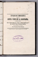
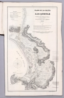
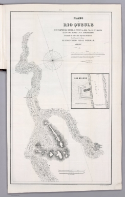
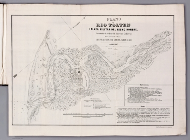

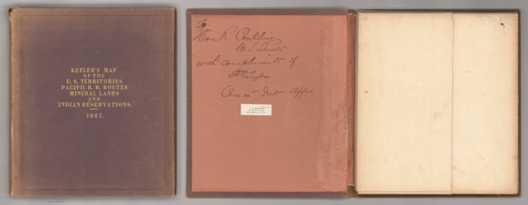

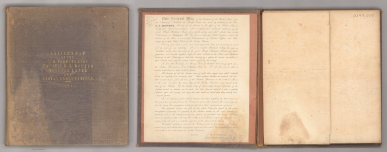

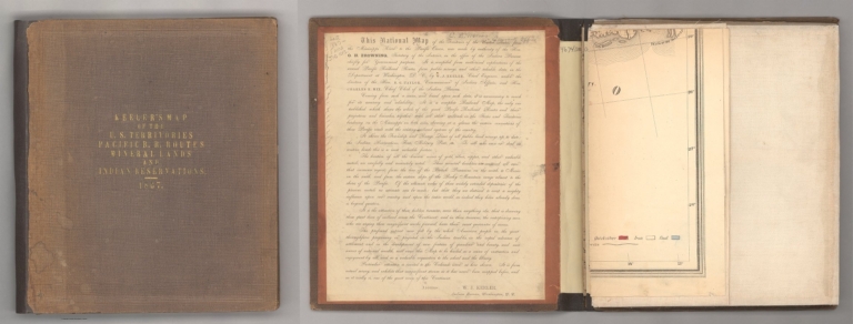


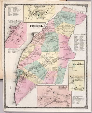


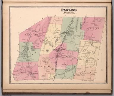


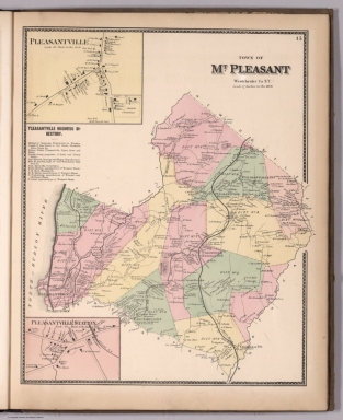


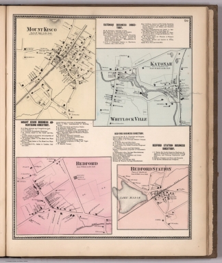


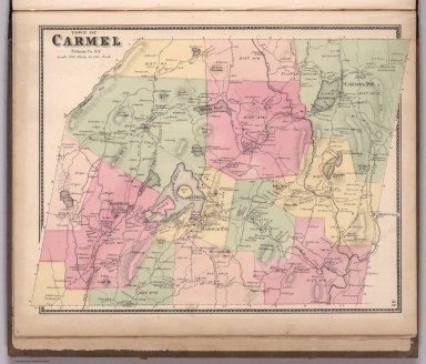


![Text: [Book plate] ...](https://www.davidrumsey.com/rumsey/Size2/RUMSEY~8~1/205/14329002.jpg)


