|
Author
Zettle, Ludwig (1821-1891)
Full Title
(Covers to) Plan der Haupt-u. Residenz Stadt Wein mit der neuen Bezirkseintheilung, Strassenbenennung under Häuser-Nummerirung.
List No
15960.001
Author
Zettle, Ludwig (1821-1891)
Full Title
Plan der Haupt-u. Residenz Stadt Wein mit der neuen Bezirkseintheilung, Strassenbenennung under Häuser-Nummerirung.
List No
15960.002
Author
[Gifford, C. B. (Charles B.), Nagel, L. (Louis)]
Full Title
Lone Mountain Cemetery. San Francisco.
List No
15448.000
Author
Andriveau-Goujon, J.
Full Title
(Covers to) Carte Generale des Routes, Des Chemins De Fer et des principales Voies Navigables De L'Europe, Redigee d'apres les Itineraires les plus recents et des Documents fournis Par Le Ministere Des Travaux Publics. (Bureau central de Statistique.) Publiee Par J. Andriveau-Goujon, Rue du Bac, 21. Paris - 1866. Paris, Impie. de Chardon Jne. fils, Rue Racine, 3. Grave par P. Rousset.
List No
1500.001
Author
Andriveau-Goujon, J.
Full Title
Carte Generale des Routes, Des Chemins De Fer et des principales Voies Navigables De L'Europe, Redigee d'apres les Itineraires les plus recents et des Documents fournis Par Le Ministere Des Travaux Publics. (Bureau central de Statistique.) Publiee Par J. Andriveau-Goujon, Rue du Bac, 21. Paris - 1866. Paris, Impie. de Chardon Jne. fils, Rue Racine, 3. Grave par P. Rousset.
List No
1500.002
Author
Bertillon, Louis-Adolphe, 1821-1883
Full Title
Mortalité de 0 à 1 an. 2 sexes rèunis : Carte I. Mortalité des enfants de 0 à 1 an. pendant la période 1857-66. Par le docteur Bertillon. 1871.
List No
14345.006
Note
Statistical map of France. Shows childhood mortality rates between birth to age one year, from 1857-1866. Delineates the country according to French departments. Indexed, with key in margins. Includes a legend, explanatory note and descriptive text. Black and white lithograph. Map is 22 x 21 cm, on sheet 45 x 28 cm. Facing plate features a comparable map - Carte II - showing childhood mortality rates between ages one to five years, from 1857 to 1866. Appears in Section B, 3rd Series.
Author
Bertillon, Louis-Adolphe, 1821-1883
Full Title
Mortalité de 1 à 5 ans. 2 sexes rèunis : Carte II. Mortalité des enfants de 1 à 5 ans. pendant la période 1857-66. Par le docteur Bertillon. 1871.
List No
14345.007
Note
Statistical map of France. Shows childhood mortality rates between ages one to five years, from 1857-1866. Delineates the country according to French departments. Indexed, with key in margins. Includes a legend, explanatory note and descriptive text. Black and white lithograph. Map is 22 x 21 cm, on sheet 45 x 28 cm. Facing plate features a comparable map - Carte I - showing childhood mortality rates between birth to age one year, from 1857 to 1866. Appears in Section B, 3rd Series.
Author
Bertillon, Louis-Adolphe, 1821-1883
Full Title
Mortalité de la première année de la vie. Comparaison (d'aprés les leintes) de la France de 1840-49 avec la France de 1857-66 dans l'une e l'autre cartes les mêmes teintes correspondens á la mêine mortalité : Carte III. Dîme mortuaire de 0 à 1 an pendant la période 1840-49. Par le docteur Bertillon. 1871. -- Carte IV. Dîme mortuaire de 0 à 1 an pendant la période 1857-66. Par le docteur Bertillon. 1871.
List No
14345.008
Note
Two comparative statistical maps of France. Maps show childhood mortality rates between birth to age one year, comparing the period of 1840-1849 (Carte III, left) to 1857-1866 (Carte IV, right). Each map delineates the country according to French departments. Maps indexed, with keys for each in margins. Maps include legends, explanatory notes and descriptive text. Black and white lithograph. Together, maps are 22 x 49 cm, on double-sheet 45 x 57 cm. Maps appear in Section B, 3rd Series.
Author
Bertillon, Louis-Adolphe, 1821-1883
Full Title
Mortalité de 1 à 5 ans. Comparaison (d'aprés les leintes) de la France de 1840-49 avec la France de 1857-66 dans l'une e l'autre cartes les mêmes teintes correspondens á la mêine mortalité : Carte V. Mortalité des enfants de 1 à 5 ans pendant la période 1840-49. Par le docteur Bertillon. 1872. -- Carte VI. Mortalité des enfants de 1 à 5 ans pendant la période 1857-66. Par le docteur Bertillon. 1872. Lith. Ch. Chauvin 8, r. d. Ulm.
List No
14345.009
Note
Two comparative statistical maps of France. Maps show childhood mortality rates between ages one to five years, comparing the period of 1840-1849 (Carte V, left) to 1857-1866 (Carte VI, right). Each map delineates the country according to French departments. Maps indexed, with keys for each in margins. Maps include legends, explanatory notes and descriptive text. Black and white lithograph. Together, maps are 22 x 49 cm, on double-sheet 45 x 57 cm. Maps appear in Section B, 3rd Series.
Author
Bertillon, Louis-Adolphe, 1821-1883
Full Title
Lois ou table de la mortalité annuelle propre à chaque année d'âge de 0 à 5 ans et à chaque période quinquennale d'âge de 5 à 95 ans et pour chaque sexe, période 1857-66 (les fins pointillés déterminant les colonnettes et les chiffres en parenthéses se rapportent à la période 1840-59) : Carte XXXIII. Par le docteur Bertillon. 1872. -- Carte XXXIV. Par le docteur Bertillon. 1872 : Figure 1. Les nombres placés au sommes de chaque colonnette indiqueni les décès annuels pour 1000 vivants de chaque groupe d'âge ... -- Figure 2. Reproduction quintuplée en hauteai d'une portion de la Figure 1.
List No
14345.023
Note
Two comparative statistical charts of France. Charts show annual mortality rates specific to each year of age from zero to five, and to each five-year period from five to ninety-five years, for each sex, during the period of 1857-1866. Charts include explanatory notes and descriptive text. Black and white lithograph. Together, charts are 31 x 53 cm, on double-sheet 45 x 57 cm. Charts appear in Section B, 3rd Series.
Author
Bertillon, Louis-Adolphe, 1821-1883
Full Title
Mortalité des enfants de 0 à 12 mois comparée d'après leurs âges, leur sexe (Fig 3), leur habitat (Fig 4) en France (1857-66) et en suède (1860-66) : Carte XLIII. Par le docteur Bertillon. 1872. -- Carte XLIV. Par le docteur Bertillon. 1872 : Fig. 1ére. Mortalité comparée de semaine en semaine pendant la durée du premier mois de vie -- Figure 2ème -- Figure 3ème -- Figure 4ème.
List No
14345.028
Note
Four comparative statistical charts of France and Sweden. Charts show childhood mortality rates between ages birth and twelve months, delineated according to each of the four weeks during the first month of life (Fig. 1), ages one to twelve months (Figure 2), sex (Figure 3) and location (Figure 4), during the period of 1857-1866. Charts include explanatory notes and descriptive text. Black and white lithograph. Together, charts are 41 x 53 cm, on double-sheet 45 x 57 cm. Chart and table appear in Section B, 3rd Series.
Author
Bertillon, Louis-Adolphe, 1821-1883
Full Title
Mortalité selon les groupes d'etat civil : Mortalité des célibataires ayant atteint l'âge légal du mariage : Carte XLV. Par le docteur Bertillon. 1872. -- Carte XLV. Par le docteur Bertillon. 1872 : Mortalité des célibataires hommes de 18 ans et au-delà périod 1857-66 -- Mortalité des célibataires femmes de 15 ans et au-delà périod 1857-66.
List No
14345.029
Note
Two comparative statistical maps of France. Maps show mortality rates according to marital status groups, featuring mortality rates for single men aged eighteen years and older (Carte XLV) and single women aged fifteen years and older (Carte XLVI), during the period of 1857-1866. Maps include legends, explanatory notes and descriptive text. Black and white lithograph. Together, maps are 22 x 49 cm, on double-sheet 45 x 57 cm. Maps appear in Section B, 3rd Series.
Author
[France. Ministère des travaux publics. Administration des routes, France. Direction des cartes, plans et archives et de la statistique graphique, École nationale des ponts et chaussées (France)]
Full Title
Saïgon. (1866) Manille : Saïgon. (1866) -- Manille. 4e Série. Pl. XIX. Ministère des Travaux Publics. Ecole des Ponts et Chaussées. Lith. A. Simon, 13, R. du Val-de-Grâce. Paris.
List No
14306.109
Note
Two maps showing the ports of Saïgon [Ho Chi Minh City], Vietnam, and Manila, Philippines, in 1866. Maps feature vegetation, railways, streets, bridges, drainage, docks, islands and soundings, with depths given in meters. Each includes a bar scale and compass rose, with north oriented toward right of sheet. Descriptive text throughout. Lithograph in black, white and blue. Together, maps are 28 x 22 cm, on sheet 33 x 25 cm. Appears in Quatrième livraison.
Author
[France. Ministère des travaux publics. Administration des routes, France. Direction des cartes, plans et archives et de la statistique graphique, École nationale des ponts et chaussées (France)]
Full Title
Victoria (Hong-Kong). Singapore : Victoria. (1888) -- Hong-Kong. (1888) -- Singapore (1888). 4e Série. Pl. XXI. Ministère des Travaux Publics. Ecole des Ponts et Chaussées. Lith. A. Simon, 13, R. du Val-de-Grâce. Paris.
List No
14306.111
Note
Three maps showing the ports of Victoria and Hong Kong, China, and Singapore, in 1888. Maps feature topography, railways, streets, bridges, drainage, docks, islands and soundings, with depths given in meters. Relief shown with hachures. Each includes a bar scale and compass rose, with north oriented toward top of sheet. Descriptive text throughout. Lithograph in black, white and blue. With inset map: Singapore (1888). Together, maps are 29 x 46 cm, on sheet 33 x 50 cm. Bookplate title pasted to verso: Pl. XXI. Victoria (Hong-Kong), Singapore. Appears in Quatrième livraison.
Author
Coloney, Fairchild & Co.
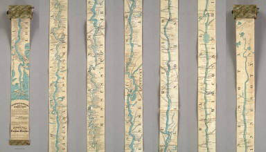
Full Title
Coloney & Fairchild's Patent Ribbon Maps ... Ribbon Map Of The Father Of Waters. Geographical and Scenic Maps upon this plan of all the rivers, rail road routes, stage and coast lines in the country are in preparation.
List No
4995.000
Note
This is the most ambitious Coloney & Fairchild strip or ribbon map: it shows the Mississippi River from its delta to its source at Lake Itaska, a distance of 2600 miles. It is backed on linen and rolls into paper covered spool with a hand crank. This is the revised edition, with much additional material added on river towns by William Bowen, President of the Pilot's Association of St. Louis (this information comes from the promotion for this map printed on the Ribbon Map of New York City). No record of the first issue found, although a copy exists at the Minnesota Historical Society. The river is colored blue against a black and white background. Distances from New Orleans are printed on the river at intervals to the source. Karrow's listing is for a variant: the map printed in five strips on one sheet and folded into the 1866 edition of Edward's Gazetteer of the Mississippi River. Scarce.
Author
Coloney, Fairchild & Co.
Full Title
Coloney & Fairchild's Patent Ribbon Maps ... Ribbon Map Of The Father Of Waters. Geographical and Scenic Maps upon this plan of all the rivers, rail road routes, stage and coast lines in the country are in preparation.
List No
4995.001
Note
This is the most ambitious Coloney & Fairchild strip or ribbon map: it shows the Mississippi River from its delta to its source at Lake Itaska, a distance of 2600 miles. It is backed on linen and rolls into paper covered spool with a hand crank. This is the revised edition, with much additional material added on river towns by William Bowen, President of the Pilot's Association of St. Louis (this information comes from the promotion for this map printed on the Ribbon Map of New York City). No record of the first issue found, although a copy exists at the Minnesota Historical Society. The river is colored blue against a black and white background. Distances from New Orleans are printed on the river at intervals to the source. Karrow's listing is for a variant: the map printed in five strips on one sheet and folded into the 1866 edition of Edward's Gazetteer of the Mississippi River. Scarce.
Author
Heyberger, Josef
Full Title
(Covers to) Plan der königlichen Haupt- und Residenz- Stadt München. Neu bearbeitet v. J. Heyberger.
List No
10775.001
Note
Date estimated.
Author
Heyberger, Josef
Full Title
(Text page to) Plan der königlichen Haupt- und Residenz- Stadt München. Neu bearbeitet v. J. Heyberger.
List No
10775.002
Note
Date estimated.
Author
Heyberger, Josef
Full Title
Plan der königlichen Haupt- und Residenz- Stadt München. Neu bearbeitet v. J. Heyberger.
List No
10775.003
Note
Date estimated.
Author
Allodi, Pietro (fl. 1859-1878)
Full Title
(Covers to) Nuova Carta Topografica Del Lago Di Como.
List No
10577.001
Note
See our 10541.000 for an earlier version of this map.
Author
Allodi, Pietro (fl. 1859-1878)
Full Title
Nuova Carta Topografica Del Lago Di Como.
List No
10577.002
Note
See our 10541.000 for an earlier version of this map.
Author
Italy. Direzione Generale del, Censo
Full Title
Pianta topografica di Roma. Publicata della Direzione, Generale del, Censo ed aggiornata a tutto il ccorrente anno MDCCCLXVI (1866).
List No
11956.000
Note
Topographic map of Rome, dissected and mounted on linen, 120 x 159, folded to 21x27. Published by the Directorate, General of the Census and updated in 1866. Relief shown by hachures. Includes index to places and districts. Shows 14 districts, names of streets, public buildings, landmarks, plazas, churches, rivers, drainage, fortress and other points of interest. Some buildings shown pictorially.
Author
Kiepert, Heinrich, 1818-1899
Full Title
Die Nillander. Neue Bearbeitung. Berichtgt 1866. Stich. v. J. Sulzer. Durck v. F. Barth. (to accompany) H. Kiepert's Neuer Handatlas No. 34. Berlin BEI Dietrich Reimer. (inset) Das Nil-Delta.
List No
11693.045
Note
Double page hand colored in outline map. Color coded by political and administrative boundaries. Includes legend and text. Relief shown by hachures. Prime meridians are Ferro, Greenwich and Paris.
Author
Stanford, Edward
Full Title
(Composite with Index Map and Legend) Stanford's Library Map of London and Its Suburbs. 24 Sheets. On the Scale of Six Inches to a Mile. London: Edward Stanford, 55, Charing Cross, S.W.
List No
10103.001
Note
Composite of labels on the backs of six map sheets.
Author
Stanford, Edward
Full Title
(Composite Map) (Stanford's Library Map of London and Its Suburbs.)
List No
10103.007
Note
Merging inner borders of the four maps.
Author
[Davis, Oscar, Gast, Moeller & Co.]
Full Title
Map of Omaha City, Nebraska. Published by Oscar F. Davis, surveyor & real estate agent, Omaha, Nebraska. 1866. Gast, Moeller & Co., lithographers, St. Louis, MO. Entered ... 1866, by Oscar Davis ... Nebraska.
List No
11706.000
Note
Lithographed map, with decorative border. Shows townships, sections, subdivisions, land owners, farm houses, rural buildings, roads, railroads and river. Includes a decorative compass rose oriented with the north to upper right margin. Among the earliest plans of Omaha. Much information with streets and many property owners named. The route of the Union Pacific RR is marked. A handsome lithograph with an acanthus leaf border, steam ferry in the Missouri River, decorative direction indicator. At top left is an idealized image of the neoclassical Territorial Capitol before its dome was completed. Oscar F. Davis was an early Omaha settler with a surveying and engineering business. He later became land commissioner for the Union Pacific.
Author
Larrance, Isaac, 1804-1896
Full Title
(Covers to) Larrance's Post office chart, and maps of ten states, showing the locality of the counties and county seats in a moment, by figures: to which is appended an easy way to calculate interest at any per cent. By Isaac Larrance. Cincinnati : Printed and for sale by I. A. Pittman. 1866. (on verso title page) Entered according to Act of Congress in the year eighteen hundred and sixty six, by Isaac Larrance ... Ohio.
List No
11666.001
Note
19th century pocket atlas for use by postmasters in 48 pages. With 20 woodcut maps, covering Western States, printed in red and blue, with corresponding listings of the counties and county seats. Includes additional maps of Pennsylvania pasted on page 48 and inside back cover. Each map presented in two versions, one naming each county and the other naming each county seat, tables correspond with a numbered grid on each map to aid in locating the county or seat. On page 5 is a short testimonial, dated Nov.10, 1858, from Abraham Lincoln "Having hastily examined Larrance's Post Office chart and considered the principal upon which it is arranged, I think it will prove a great convenience to Post Masters and others whose business leads them to search out particular localities upon maps." Under the Lincoln quote is this statement: "A diploma was awarded by the United States Fair, held at Cincinnati, 1860, to Isaac Larrance." Atlas is bound in cloth covered boards, blind stamped on back and front covers with "Larrance's Post office charts and maps of Western States." in gilt on front cover.
Author
Larrance, Isaac, 1804-1896
Full Title
(Title Page to) Larrance's Post office chart, and maps of ten states, showing the locality of the counties and county seats in a moment, by figures: to which is appended an easy way to calculate interest at any per cent. By Isaac Larrance. Cincinnati : Printed and for sale by I. A. Pittman. 1866. (on verso title page) Entered according to Act of Congress in the year eighteen hundred and sixty six, by Isaac Larrance ... Ohio.
List No
11666.002
Note
19th century pocket atlas for use by postmasters in 48 pages. With 20 woodcut maps, covering Western States, printed in red and blue, with corresponding listings of the counties and county seats. Includes additional maps of Pennsylvania pasted on page 48 and inside back cover. Each map presented in two versions, one naming each county and the other naming each county seat, tables correspond with a numbered grid on each map to aid in locating the county or seat. On page 5 is a short testimonial, dated Nov.10, 1858, from Abraham Lincoln "Having hastily examined Larrance's Post Office chart and considered the principal upon which it is arranged, I think it will prove a great convenience to Post Masters and others whose business leads them to search out particular localities upon maps." Under the Lincoln quote is this statement: "A diploma was awarded by the United States Fair, held at Cincinnati, 1860, to Isaac Larrance." Atlas is bound in cloth covered boards, blind stamped on back and front covers with "Larrance's Post office charts and maps of Western States." in gilt on front cover.
Author
Larrance, Isaac, 1804-1896
Full Title
(Contents to) Larrance's Post office chart, and maps of ten states, showing the locality of the counties and county seats in a moment, by figures: to which is appended an easy way to calculate interest at any per cent. By Isaac Larrance. Cincinnati : Printed and for sale by I. A. Pittman. 1866. (on verso title page) Entered according to Act of Congress in the year eighteen hundred and sixty six, by Isaac Larrance ... Ohio.
List No
11666.003
Note
19th century pocket atlas for use by postmasters in 48 pages. With 20 woodcut maps, covering Western States, printed in red and blue, with corresponding listings of the counties and county seats. Includes additional maps of Pennsylvania pasted on page 48 and inside back cover. Each map presented in two versions, one naming each county and the other naming each county seat, tables correspond with a numbered grid on each map to aid in locating the county or seat. On page 5 is a short testimonial, dated Nov.10, 1858, from Abraham Lincoln "Having hastily examined Larrance's Post Office chart and considered the principal upon which it is arranged, I think it will prove a great convenience to Post Masters and others whose business leads them to search out particular localities upon maps." Under the Lincoln quote is this statement: "A diploma was awarded by the United States Fair, held at Cincinnati, 1860, to Isaac Larrance." Atlas is bound in cloth covered boards, blind stamped on back and front covers with "Larrance's Post office charts and maps of Western States." in gilt on front cover.
Author
Larrance, Isaac, 1804-1896
Full Title
(Text Page to) Larrance's Post office chart, and maps of ten states, showing the locality of the counties and county seats in a moment, by figures: to which is appended an easy way to calculate interest at any per cent. By Isaac Larrance. Cincinnati : Printed and for sale by I. A. Pittman. 1866. (on verso title page) Entered according to Act of Congress in the year eighteen hundred and sixty six, by Isaac Larrance ... Ohio.
List No
11666.004
Note
19th century pocket atlas for use by postmasters in 48 pages. With 20 woodcut maps, covering Western States, printed in red and blue, with corresponding listings of the counties and county seats. Includes additional maps of Pennsylvania pasted on page 48 and inside back cover. Each map presented in two versions, one naming each county and the other naming each county seat, tables correspond with a numbered grid on each map to aid in locating the county or seat. On page 5 is a short testimonial, dated Nov.10, 1858, from Abraham Lincoln "Having hastily examined Larrance's Post Office chart and considered the principal upon which it is arranged, I think it will prove a great convenience to Post Masters and others whose business leads them to search out particular localities upon maps." Under the Lincoln quote is this statement: "A diploma was awarded by the United States Fair, held at Cincinnati, 1860, to Isaac Larrance." Atlas is bound in cloth covered boards, blind stamped on back and front covers with "Larrance's Post office charts and maps of Western States." in gilt on front cover.
Author
Larrance, Isaac, 1804-1896
Full Title
(Index Page to) Ohio Counties. (to accompany) Larrance's Post office chart, and maps of ten states ... By Isaac Larrance. Cincinnati : Printed and for sale by I. A. Pittman. 1866.
List No
11666.005
Note
Index to Ohio Counties. "The figures opposite the names of each county refer to the figures on the sides of the map. "
Author
Larrance, Isaac, 1804-1896
Full Title
Counties in Ohio. (to accompany) Larrance's Post office chart, and maps of ten states ... By Isaac Larrance. Cincinnati : Printed and for sale by I. A. Pittman. 1866.
List No
11666.006
Note
Color map of the Ohio counties. Shows county boundaries, towns and railroads.
Author
Bowers, A.B.
Full Title
Map Of Sonoma County California. Made and Published by A.B. Bowers, In Accordance with an Act of the Legislature, approved 28 March 1863, With Additions and Corrections to The Date of Publication. E. Fletcher Lith. 308 Front St. S.F. (with 4 inset maps).
List No
10080.000
Note
First edition, not listed by Vodges - he lists the 1867 second edition, see our 4222.000. With four inset maps of towns. This is the earliest wall map of Sonoma County that we have seen.
Author
United States Coast Survey
Full Title
Coast Chart No. 20 New York Bay And Harbor, New York. From a Trigonometric Survey under the direction of A.D. Bache Superintendent of the Survey Of The Coast Of The United States ... Published in 1866. Verified J.E. Hilgard Assist. Coast Survey In charge of Office. Electrotype Copy No. 3 by G. Mathiot U.S.C.S. Redd. Drng. by E. Hergesheimer, M.H. McClery and A. Balbach. Engd. by J. Enthoffer, J. Knight, H.S. Barnard and J.C. Kondrup.
List No
5328.000
Note
Without color. Includes information about the location of light houses and beacons, tidal changes, and variations of the magnetic needle.
Author
[Bancroft, H.H., Clarke, Charles R.]
Full Title
(NW Sheet) Outline Map Of The Pacific States. Designed To Accompany Clarke's Series Of Geographies And Being No.IV Of Bancroft's Geographical And Historical Series. Published by H.H. Bancroft & Co. Booksellers and Stationers, San Francisco, Cal. 1866. Entered ... 1866 by H.H. Bancroft & Company ... California.
List No
0142.001
Note
SW map in facsimile; four sheets. From Warren Heckrotte, who has a complete set. Originally from the Bancroft Library. See the Clarke School Geography. There was a key to these maps published separately. The maps are very detailed and accurate. Full color. Relief shown by hachures.
Author
[Bancroft, H.H., Clarke, Charles R.]
Full Title
(NE Sheet) Outline Map Of The Pacific States. Designed To Accompany Clarke's Series Of Geographies And Being No.IV Of Bancroft's Geographical And Historical Series. Published by H.H. Bancroft & Co. Booksellers and Stationers, San Francisco, Cal. 1866. Entered ... 1866 by H.H. Bancroft & Company ... California.
List No
0142.002
Note
SW map in facsimile; four sheets. From Warren Heckrotte, who has a complete set. Originally from the Bancroft Library. See the Clarke School Geography. There was a key to these maps published separately. The maps are very detailed and accurate. Full color. Relief shown by hachures.
Author
[Bancroft, H.H., Clarke, Charles R.]
Full Title
(SW Sheet) Outline Map Of The Pacific States. Designed To Accompany Clarke's Series Of Geographies And Being No.IV Of Bancroft's Geographical And Historical Series. Published by H.H. Bancroft & Co. Booksellers and Stationers, San Francisco, Cal. 1866. Entered ... 1866 by H.H. Bancroft & Company ... California.
List No
0142.003
Note
SW map in facsimile; four sheets. From Warren Heckrotte, who has a complete set. Originally from the Bancroft Library. See the Clarke School Geography. There was a key to these maps published separately. The maps are very detailed and accurate. Full color. Relief shown by hachures.
Author
[Bancroft, H.H., Clarke, Charles R.]
Full Title
(SE Sheet) Outline Map Of The Pacific States. Designed To Accompany Clarke's Series Of Geographies And Being No.IV Of Bancroft's Geographical And Historical Series. Published by H.H. Bancroft & Co. Booksellers and Stationers, San Francisco, Cal. 1866. Entered ... 1866 by H.H. Bancroft & Company ... California.
List No
0142.004
Note
SW map in facsimile; four sheets. From Warren Heckrotte, who has a complete set. Originally from the Bancroft Library. See the Clarke School Geography. There was a key to these maps published separately. The maps are very detailed and accurate. Full color. Relief shown by hachures.
Author
[Bancroft, H.H., Clarke, Charles R.]
Full Title
(Composite of) Outline Map Of The Pacific States. Designed To Accompany Clarke's Series Of Geographies And Being No.IV Of Bancroft's Geographical And Historical Series. Published by H.H. Bancroft & Co. Booksellers and Stationers, San Francisco, Cal. 1866. Entered ... 1866 by H.H. Bancroft & Company ... California.
List No
0142.005
Note
SW map in facsimile; four sheets. From Warren Heckrotte, who has a complete set. Originally from the Bancroft Library. See the Clarke School Geography. There was a key to these maps published separately. The maps are very detailed and accurate. Full color. Relief shown by hachures.
Author
Dutton, E.P.
Full Title
(Covers to) New Map Of Massachusetts Compiled from The latest and best Authorities. Published At The Boston Map Store, E.P. Dutton & Co. 135 Washington Street, Boston, 1866. Entered ... 1863 by E.P Dutton & Co ... Massachusetts. (inset) Salem. (inset) Springfield. (inset) Worchester. (inset) Lowell. (inset) Boston.
List No
0253.001
Note
Catalogue of Boston Map Store inside front cover. Folded into dark green cloth covers 14.5x9 with "E.P Dutton & Co's. Map Of Massachusetts With Railroads & Townships." in gilt. (inset)Table of Distance.
Author
Dutton, E.P.
Full Title
New Map Of Massachusetts Compiled from The latest and best Authorities. Published At The Boston Map Store, E.P. Dutton & Co. 135 Washington Street, Boston, 1866. Entered ... 1863 by E.P Dutton & Co ... Massachusetts. (inset) Salem. (inset) Springfield. (inset) Worchester. (inset) Lowell. (inset) Boston.
List No
0253.002
Note
Catalogue of Boston Map Store inside front cover. Folded into dark green cloth covers 14.5x9 with "E.P Dutton & Co's. Map Of Massachusetts With Railroads & Townships." in gilt. (inset) Table of Distance.
Author
Stieler, Adolf
Full Title
Stieler's Hand-Atlas ... No. 8. Planiglob der Antipoden.
List No
0960.012
Author
Stieler, Adolf
Full Title
Stieler's Hand-Atlas ... No. 14d. Sudwestliches Frankreich. (insets) Lyon. Paris.
List No
0960.020
Author
[Stieler, Adolf, Petermann, A.]
Full Title
Stieler's Hand-Atlas ... No. 15d. Ireland. (insets) Dublin und Dublin Bay. Die See'n von Killarney.
List No
0960.022
Author
[Stieler, Adolf, Petermann, A.]
Full Title
Stieler's Hand-Atlas ... No. 15c. Grossbritannien. (inset) Die Shetland und Orkney Inseln. Edinbugh und Umgebung.
List No
0960.023
Author
[Stieler, Adolf, Vogel, C.]
Full Title
Stieler's Hand-Atlas ... No. 26. Der Oesterreichische Kaiserstaat. (inset) Wien.
List No
0960.048
Author
[Stieler, Adolf, Petermann, A.]
Full Title
Stieler's Hand-Atlas ... No. 37b: Ost-Europe, Nordost-Russland.
List No
0960.052
Author
[Stieler, Adolf, Vogel, C.]
Full Title
Stieler's Hand-Atlas ... No. 27 & 28. Sachsen, Thuringen und Benachbarte Laender.
List No
0960.057
Note
Includes profile of mountains.
Author
[Stieler, Adolf, Petermann, A.]
Full Title
Stieler's Hand-Atlas ... No. 34b. Sud-Italien. (insets) Neapel und Umgegend. Sardinien. Palermo.
List No
0960.061
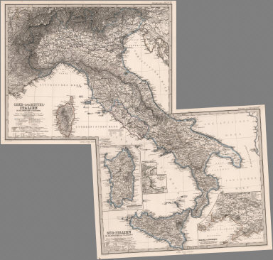
Author
[Stieler, Adolf, Petermann, A.]
Full Title
(Composite of) Stieler's Hand-Atlas ... Italien.
List No
0960.108
|