|
Author
Byrne, Oliver
Full Title
The Young Geometrician; or Practical Geometry without Compasses.
List No
15465.001
Author
Byrne, Oliver
Full Title
(Title page to) The Young Geometrician; or Practical Geometry without Compasses.
List No
15465.003
Author
Byrne, Oliver
Full Title
(Text page to) The Young Geometrician; or Practical Geometry without Compasses.
List No
15465.004
Author
Byrne, Oliver
Full Title
(Text page to) The Young Geometrician; or Practical Geometry without Compasses.
List No
15465.005
Author
Byrne, Oliver
Full Title
Pages 1, 2. The Young Geometrician; or Practical Geometry without Compasses.
List No
15465.006
Author
Byrne, Oliver
Full Title
Pages 3, 4. The Young Geometrician; or Practical Geometry without Compasses.
List No
15465.007
Author
Byrne, Oliver
Full Title
Problem II. The Young Geometrician; or Practical Geometry without Compasses.
List No
15465.011
Author
Byrne, Oliver
Full Title
Problem III. The Young Geometrician; or Practical Geometry without Compasses.
List No
15465.012
Author
Byrne, Oliver
Full Title
Problem IV. The Young Geometrician; or Practical Geometry without Compasses.
List No
15465.013
Author
Byrne, Oliver
Full Title
Problem X. The Young Geometrician; or Practical Geometry without Compasses.
List No
15465.019
Author
Byrne, Oliver
Full Title
Problem XVI. The Young Geometrician; or Practical Geometry without Compasses.
List No
15465.025
Author
Byrne, Oliver
Full Title
Problem XVII. The Young Geometrician; or Practical Geometry without Compasses.
List No
15465.026
Author
Byrne, Oliver
Full Title
Problem XVIII. The Young Geometrician; or Practical Geometry without Compasses.
List No
15465.027
Author
Byrne, Oliver
Full Title
Problem XX. The Young Geometrician; or Practical Geometry without Compasses.
List No
15465.029
Author
Byrne, Oliver
Full Title
Problem XXI. The Young Geometrician; or Practical Geometry without Compasses.
List No
15465.030
Author
Byrne, Oliver
Full Title
Problem XXII. The Young Geometrician; or Practical Geometry without Compasses.
List No
15465.031
Author
[Vallardi, Francesco, Amati]
Full Title
Carta dell'Isola di Sardegna. Milano dal Dott. Franc. Vallardi. Riveduta dal Profe. Amati nel 1865.
List No
14396.072
Note
Political map of the island of Sardinia, Italy. Features political boundaries, cities, railways, roads, topography, bodies of water, drainage, coastline and islands. Relief shown with hachures. Includes a legend, latitudinal and longitudinal lines, as well as three bar scales. Colored engraving. Map is 56 x 42 cm, on double sheet 84 x 60 cm. Within section entitled Isola.
Author
Howell, C.W.
Full Title
(Covers to) Map Of The Battle Fields Of The Wilderness May 5th 6th and 7th 1864. Showing the Field of Operations of the Army of the Potomac Commanded by Maj. Gen. George G. Meade U.S.A. Surveyed under the orders of Bvt. Col. J.C. Duane ... By Bvt. Maj. C.W. Howell 1st Lieut. of Engineers. Assisted by Messrs. L.C. Oswell, L. Bell and R.B. Talfor. Topographical Engineers. Instruments Used Schmalcalder Compass Odometer and Tape-Measure, Time 3 days. J. Bien, Lith. 24 Vesey St. N.Y.
List No
3865.001
Note
Date estimated.
Author
Howell, C.W.
Full Title
Map Of The Battle Fields Of The Wilderness May 5th 6th and 7th 1864. Showing the Field of Operations of the Army of the Potomac Commanded by Maj. Gen. George G. Meade U.S.A. Surveyed under the orders of Bvt. Col. J.C. Duane ... By Bvt. Maj. C.W. Howell 1st Lieut. of Engineers. Assisted by Messrs. L.C. Oswell, L. Bell and R.B. Talfor. Topographical Engineers. Instruments Used Schmalcalder Compass Odometer and Tape-Measure, Time 3 days. J. Bien, Lith. 24 Vesey St. N.Y.
List No
3865.002
Note
Date estimated.
Author
Comstock, Cyrus B.
Full Title
(Covers to) Plan and Sections of Fort Fisher Carried by assault by the U.S. Forces, Maj. Gen. A.H. Terry Commanding Jan 15th, 1865. Head Qurtrs. U.S. Forces Fort Fisher, Jan. 27th 1865. Forwarded to Engineer Dept. with letter of this date. C.B. Comstock, Lt. Col. A.D.C. & Brvt. Brig. Gen. Engraved in the Engineer Bureau, War Dept. E. Molitor, lith.
List No
3871.001
Author
Comstock, Cyrus B.
Full Title
Plan and Sections of Fort Fisher Carried by assault by the U.S. Forces, Maj. Gen. A.H. Terry Commanding Jan 15th, 1865. Head Qurtrs. U.S. Forces Fort Fisher, Jan. 27th 1865. Forwarded to Engineer Dept. with letter of this date. C.B. Comstock, Lt. Col. A.D.C. & Brvt. Brig. Gen. Engraved in the Engineer Bureau, War Dept. E. Molitor, lith.
List No
3871.002
Author
Schultze, Otto Julian
Full Title
(Covers to) Sketch of Vicinity of Fort Fisher surveyed under the direction of Brvt. Brig. Gen. C.B. Comstock Chief Engineer by Otto Julian Schultze Private 15th N.Y.V. Eng. Engraved at the Engineer Bureau, War Dept. Ft. Fisher Feb 9th 1865 Forwarded to Engineer Dept. with letter of this date. C.B. Comstock, Lt. Col. A.D.C. & Brvt. Brig. Gen. E. Molitor, lith.
List No
3872.001
Author
Schultze, Otto Julian
Full Title
Sketch of Vicinity of Fort Fisher surveyed under the direction of Brvt. Brig. Gen. C.B. Comstock Chief Engineer by Otto Julian Schultze Private 15th N.Y.V. Eng. Engraved at the Engineer Bureau, War Dept. Ft. Fisher Feb 9th 1865 Forwarded to Engineer Dept. with letter of this date. C.B. Comstock, Lt. Col. A.D.C. & Brvt. Brig. Gen. E. Molitor, lith.
List No
3872.002
Author
Anonymous
Full Title
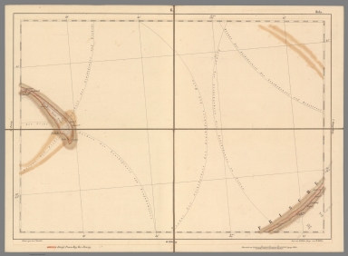
[Untitled Map of the Red River (Song Hồng) Basin, extending from Hanoi Area to Lao Cai Province, Vietnam].
List No
15384.000
Note
Date estimated.
Author
Bertillon, Louis-Adolphe, 1821-1883
Full Title
Détails sur la mortalité de la première année de la vie selon le sexe, l'etat-civil, lâge et l'habitat (France 1856-65) : Carte XXXV. Par le docteur Bertillon. 1872. -- Carte XXXVI. Par le docteur Bertillon. 1872 : Fig. 1ère. Détails de la mortalité du 1er mois de la vie -- Figure 2îme " -- Fig. 3. Mortalité du mois moyen de la 1ère année de la vie.
List No
14345.024
Note
Three comparative statistical charts of France. Charts show childhood mortality rates during the first year of life, according to sex, marital status of the parents, age in months, as well as location, during the period of 1856-1865. Charts include a shared legend, explanatory notes and descriptive text. With two tables: A. Mortalité enfantine par semaine (α), par mois (β), par an (γ), ou rapports des décès aux vivants de chaque catégorie ... [= Child mortality per week (α), per month (β), per year (γ), or death to living ratios of each category] -- B. Rapports des décès entre eux, et aux naissances vivantes ... [= Relationship of deaths to each other, and to live births]. Black and white lithograph. Together, charts are 41 x 53 cm, on double-sheet 45 x 57 cm. Charts appear in Section B, 3rd Series.
Author
Bertillon, Louis-Adolphe, 1821-1883
Full Title
Mortalité selon les mois de l'annee moyenne (période 1856-65) : Carte XXXVII. Par le docteur Bertillon. 1872. -- Carte XXXVIII. Par le docteur Bertillon. 1872 : Appréciée par la répartition mensuelle des décès annuels de chaque sexe, de chaque groupe d'âge, de chaque habitat: campagne, villes, département de la Seine -- Distribution mensuelle de 12000 décès annuels de chaque catégorie d'âge de sexe et d'habitat (en supposans tous les mois de 31 jours), et tels qu'ils sont fournis par la population.
List No
14345.025
Note
Comparative statistical chart and table of France. Chart and table show average childhood mortality rates according to months of the year, for each sex, age group (birth to twenty years) and location (countryside or city), during the period of 1856-1865. Chart and table include explanatory notes and descriptive text. Black and white lithograph. Together, charts are 30 x 53 cm, on double-sheet 45 x 57 cm. Chart and table appear in Section B, 3rd Series.
Author
Bertillon, Louis-Adolphe, 1821-1883
Full Title
Mortalité par âge et par état-civil comparée en France, à Paris, en Belgique, en Hollande aire mortuaire comparée des époux, des célibataires et des veufs en chaque groupe d'âge jusqu'à 70 ans : Carte LI. Par le docteur Bertillon. 1872. -- Carte LII. Par le docteur Bertillon. 1872 : Sexe masculin -- Sexe feminin.
List No
14345.032
Note
Two comparative statistical charts of France (including Paris), Belgium and Holland. Charts show mortality rates according to age (eighteen months to seventy years) and marital status for boys and men (Carte LI) and girls and women (Carte LII), during the period of 1850-1865. Charts include explanatory notes and descriptive text. Black and white lithograph. Together, charts are 32 x 33 cm, on double-sheet 45 x 57 cm. Charts appear in Section B, 3rd Series.
Author
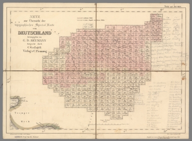
[Reymann, Daniel Gottfried, Flemming, Carl]
Full Title
2 Netz und Arcona
List No
10605.002
Author
[Reymann, Daniel Gottfried, Flemming, Carl]
Full Title
(Composite map of) Topgraphischen Special Karte von Deutschland.
List No
10605.351
Note
Date is the latest date in the series. The range of dates of the sheets is 1822 to 1865
Author
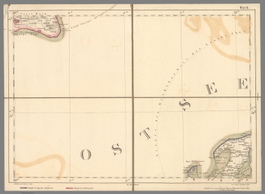
[Reymann, Daniel Gottfried, Flemming, Carl]
Full Title
1 Wieck
List No
10605.001
Author
[Reymann, Daniel Gottfried, Flemming, Carl]
Full Title
3 Musterblatt u. Rützenhagen
List No
10605.003
Author
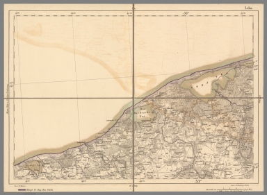
[Reymann, Daniel Gottfried, Flemming, Carl]
Full Title
4 Leba
List No
10605.004
Note
Date estimated
Author
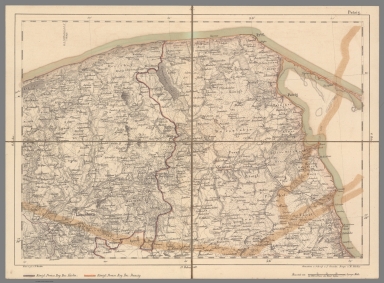
[Reymann, Daniel Gottfried, Flemming, Carl]
Full Title
5 Putzig
List No
10605.005
Author
[Reymann, Daniel Gottfried, Flemming, Carl]
Full Title
6 Hela
List No
10605.006
Author
[Reymann, Daniel Gottfried, Flemming, Carl]
Full Title
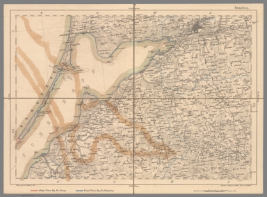
7 Koenigsberg
List No
10605.007
Note
Date estimated.
Author
[Reymann, Daniel Gottfried, Flemming, Carl]
Full Title
14 Maasstabe u. Langenhagen
List No
10605.019
Author
Decaen y Debray
Full Title
Plano general de la Ciudad de Mexico año 1865. México Lito. de Decaen y Debray.
List No
14249.000
Note
Map of Mexico City, showing the utilization of each building, with categories and names indexed at upper right. Shows streets, parks, plazas, churches, cemeteries, and the greater vicinity. Includes a compass rose and two bar scales, as well as a descriptive note. Also, lists population. In black and bronze. 33 x 45 cm, on sheet 41 x 52.
Author
Schonberg & Co.
Full Title
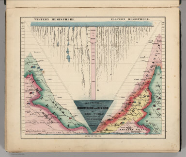
The Principal Mountains and Rivers of the World compiled from the Latest Authorities. New York. Schonberg & Co. 1864.
List No
4324.004
Note
Shows lengths of major rivers and heights of mountains; differentiated by hemisphere.
Author
Johnson, A.J.
Full Title
Johnson's Chart of Comparative Heights of Mountains and Lengths of Rivers of ... Africa, Asia, Europe, South America, and North America.
List No
0535.005
Note
Consists of five charts on one sheet.
Author
Greenough, George Bellas, (1778-1855)
Full Title
(Covers to) A Physical and Geological Map of England and Wales By G.B. Greenough Esq. F.R.S. (on the basis of the original Map of William Smith 1815) Revised and Improved under the Superintendence of a Committee of the Geological Society of London, from the maps of the Geological Survey of Great Britain, 1836-63 and the Maps and Documents contributed by Sir R. I. Murchison, Professor Phillips, Joseph Prestwich, R. Godwin Austen, and others. July 1865.
List No
10491.001
Note
Greenough first published this map in 1820, then a second edition in 1839 (see our 10496.000), and this final third posthumous edition in 1865. Greenough drew heavily on William Smith's Geological map of England and Wales but did not credit him until the third edition. There are several differences between the Greenough and Smith maps: Greenough delineates the topography and Smith does not, and Greenough's scale is 6 miles to the inch vs Smith at 5 miles to the inch. There were also differences underlying the geology of both maps. Greenough made significant revisions to the second edition and to this final third edition. Following the publication of the first 1820 edition, there was a continuing dispute between Greenough and Smith as to Greenough's uncredited use of Smith's map.
Author
Greenough, George Bellas, (1778-1855)
Full Title
N.E. Sheet. A Physical and Geological Map of England and Wales By G.B. Greenough Esq. F.R.S. (on the basis of the original Map of William Smith 1815) Revised and Improved under the Superintendence of a Committee of the Geological Society of London, from the maps of the Geological Survey of Great Britain, 1836-63 and the Maps and Documents contributed by Sir R. I. Murchison, Professor Phillips, Joseph Prestwich, R. Godwin Austen, and others. July 1865.
List No
10491.002
Note
Greenough first published this map in 1820, then a second edition in 1839 (see our 10496.000), and this final third posthumous edition in 1865. Greenough drew heavily on William Smith's Geological map of England and Wales but did not credit him until the third edition. There are several differences between the Greenough and Smith maps: Greenough delineates the topography and Smith does not, and Greenough's scale is 6 miles to the inch vs Smith at 5 miles to the inch. There were also differences underlying the geology of both maps. Greenough made significant revisions to the second edition and to this final third edition. Following the publication of the first 1820 edition, there was a continuing dispute between Greenough and Smith as to Greenough's uncredited use of Smith's map.
Author
Greenough, George Bellas, (1778-1855)
Full Title
S.E. Sheet. A Physical and Geological Map of England and Wales By G.B. Greenough Esq. F.R.S. (on the basis of the original Map of William Smith 1815) Revised and Improved under the Superintendence of a Committee of the Geological Society of London, from the maps of the Geological Survey of Great Britain, 1836-63 and the Maps and Documents contributed by Sir R. I. Murchison, Professor Phillips, Joseph Prestwich, R. Godwin Austen, and others. July 1865.
List No
10491.005
Note
Greenough first published this map in 1820, then a second edition in 1839 (see our 10496.000), and this final third posthumous edition in 1865. Greenough drew heavily on William Smith's Geological map of England and Wales but did not credit him until the third edition. There are several differences between the Greenough and Smith maps: Greenough delineates the topography and Smith does not, and Greenough's scale is 6 miles to the inch vs Smith at 5 miles to the inch. There were also differences underlying the geology of both maps. Greenough made significant revisions to the second edition and to this final third edition. Following the publication of the first 1820 edition, there was a continuing dispute between Greenough and Smith as to Greenough's uncredited use of Smith's map.
Author
Greenough, George Bellas, (1778-1855)
Full Title
(Composite map of) N.E.,N.W.,S.W.,S.E. Sheets. A Physical and Geological Map of England and Wales By G.B. Greenough Esq. F.R.S. (on the basis of the original Map of William Smith 1815) Revised and Improved under the Superintendence of a Committee of the Geological Society of London, from the maps of the Geological Survey of Great Britain, 1836-63 and the Maps and Documents contributed by Sir R. I. Murchison, Professor Phillips, Joseph Prestwich, R. Godwin Austen, and others. July 1865.
List No
10491.006
Note
Greenough first published this map in 1820, then a second edition in 1839 (see our 10496.000), and this final third posthumous edition in 1865. Greenough drew heavily on William Smith's Geological map of England and Wales but did not credit him until the third edition. There are several differences between the Greenough and Smith maps: Greenough delineates the topography and Smith does not, and Greenough's scale is 6 miles to the inch vs Smith at 5 miles to the inch. There were also differences underlying the geology of both maps. Greenough made significant revisions to the second edition and to this final third edition. Following the publication of the first 1820 edition, there was a continuing dispute between Greenough and Smith as to Greenough's uncredited use of Smith's map.
Author
Viele, Egbert L.
Full Title
(Covers to) The Topography and Hydrology of New York. By Egbert L. Viele.
List No
10156.001
Note
This is a rare variant of Viele's New York City map. It is printed on thin paper and folded into the rear of a small booklet with an essay by Viele explaining the map and its construction and the topography of New York City. The map shows all the original water courses of Manhattan Island, with the street grid superimposed on top. Also, three different kinds of land are shown: Marsh, Made Land, and Meadow. Sewer lines are indicated. This map differs in the title from the more common version issued with the Report on the Sanitary Conditions in New York (see our 3723.000)/ In 1874 Viele reissued the map in larger format as the Topographical Atlas of the City of New York (see our copy).
Author
Viele, Egbert L.
Full Title
(Title page to) The Topography and Hydrology of New York. By Egbert L. Viele.
List No
10156.002
Note
This is a rare variant of Viele's New York City map. It is printed on thin paper and folded into the rear of a small booklet with an essay by Viele explaining the map and its construction and the topography of New York City. The map shows all the original water courses of Manhattan Island, with the street grid superimposed on top. Also, three different kinds of land are shown: Marsh, Made Land, and Meadow. Sewer lines are indicated. This map differs in the title from the more common version issued with the Report on the Sanitary Conditions in New York (see our 3723.000)/ In 1874 Viele reissued the map in larger format as the Topographical Atlas of the City of New York (see our copy).
Author
Viele, Egbert L.
Full Title
(Composite text to) The Topography and Hydrology of New York. By Egbert L. Viele.
List No
10156.003
Note
This is a rare variant of Viele's New York City map. It is printed on thin paper and folded into the rear of a small booklet with an essay by Viele explaining the map and its construction and the topography of New York City. The map shows all the original water courses of Manhattan Island, with the street grid superimposed on top. Also, three different kinds of land are shown: Marsh, Made Land, and Meadow. Sewer lines are indicated. This map differs in the title from the more common version issued with the Report on the Sanitary Conditions in New York (see our 3723.000)/ In 1874 Viele reissued the map in larger format as the Topographical Atlas of the City of New York (see our copy).
Author
Viele, Egbert L.
Full Title
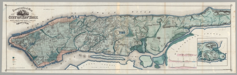
Topographical Map of the City of New York. Showing Original Water Courses and Made Land. Prepared Under the direction of Egbert L. Viele, Topographical Engineer. Entered ... 1865 by Egbert L. Viele ... New York. Ferd. Mayer & Co. Lithographers, 96 Fulton St. N.Y. (with 1 inset map and 3 profiles).
List No
10156.004
Note
This is a rare variant of Viele's New York City map. It is printed on thin paper and folded into the rear of a small booklet with an essay by Viele explaining the map and its construction and the topography of New York City. The map shows all the original water courses of Manhattan Island, with the street grid superimposed on top. Also, three different kinds of land are shown: Marsh, Made Land, and Meadow. Sewer lines are indicated. This map differs in the title from the more common version issued with the Report on the Sanitary Conditions in New York (see our 3723.000)/ In 1874 Viele reissued the map in larger format as the Topographical Atlas of the City of New York (see our copy).
Author
Anonymous
Full Title
Plano de la Isla de Lobos de Tierra mostrando Los depositos Huano. (to accompany) Las Islas de Huano. Paris. Impr. Lemercier.
List No
11864.002
Note
Plan of the Lobos de Tierra Islands. Showing the area with Guano deposits in orange. Includes notes.
Author
Anonymous
Full Title
Islas de Lobos Tierra. Deposito. B. (to accompany) Las Islas de Huano. Paris. Impr. Lemercier.
List No
11864.004
Note
Map of the Lobos de Tierra Islands. Part B. Showing the area with Guano deposits in orange. Includes explanation. Relief shown by hachures and form lines.
Author
Anonymous
Full Title
Plano de la Isla de Lobos de "Afuera" demostrado los depositos de Huano. (to accompany) Las Islas de Huano. Paris. Impr. Lemercier.
List No
11864.007
Note
Plan of Lobos de Afuera Islands. Showing the deposits of Guano in orange. Includes notes and 2 profile views of the islands at the lower panel. Prime meridian is Paris. Depth shown by soundings.
|


![[Untitled Map of the Red River (Song Hồng) Basin, extending from Hanoi Area to Lao Cai Province, Vietnam].](https://www.davidrumsey.com/rumsey/Size2/RUMSEY~8~1/199/15384000.jpg)