|
Author
[Reymann, Daniel Gottfried, Flemming, Carl]
Full Title
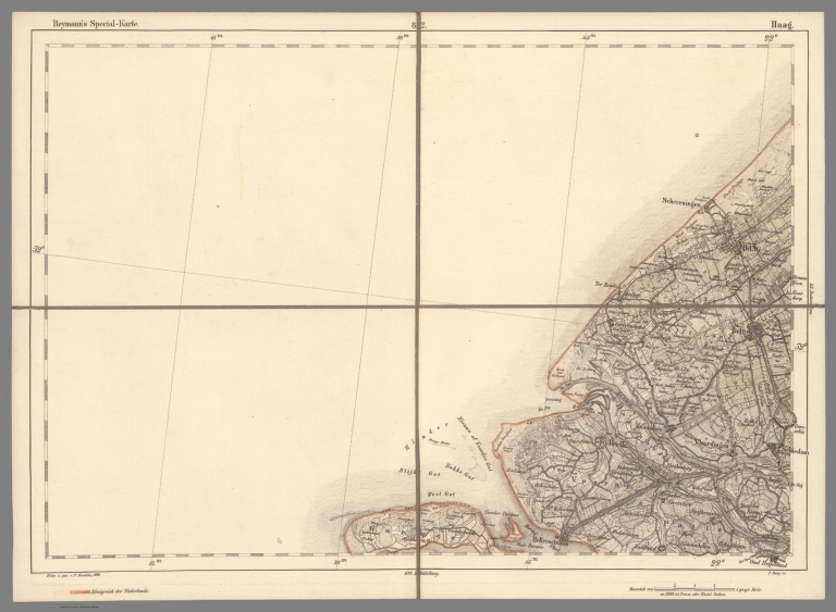
82 Haag
List No
10605.095
Author
[Reymann, Daniel Gottfried, Flemming, Carl]
Full Title
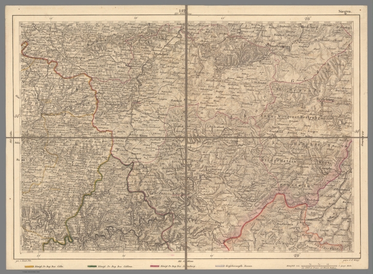
142 Siegen
List No
10605.195
Note
Date is the latest date in the series. The range of dates of the sheets is 1822 to 1865
Author
[Reymann, Daniel Gottfried, Flemming, Carl]
Full Title
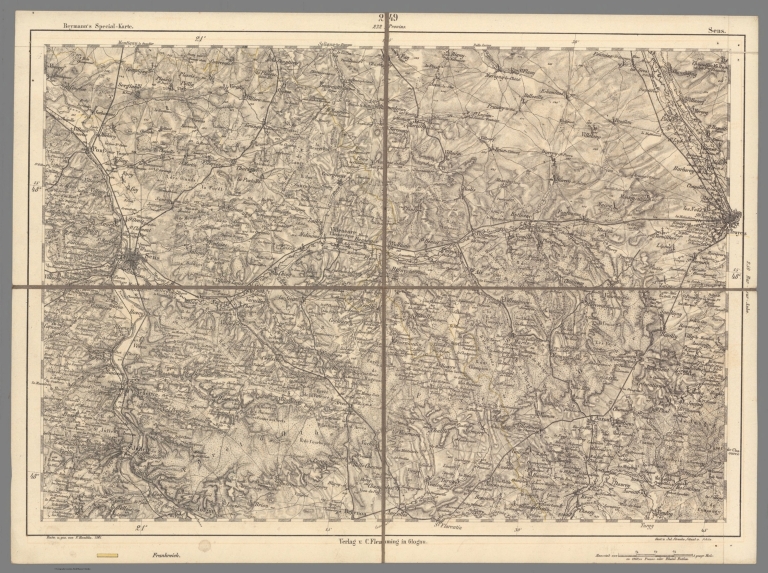
249 Sens
List No
10605.308
Note
Date is the latest date in the series. The range of dates of the sheets is 1822 to 1865
Author
U.S. General Land Office
Full Title
Map of the Public Surveys in California ; to Accompany Report of Surveyor Genl., 1861. Lith. of J. Bien, 180 Broadway, N.Y. Surveyor Generals' Office, San Francisco, California, September 15th, 1861. E.F. Beale, U.S. Survr. Genl. Cal.
List No
1073.008
Note
Eleven issues from the Annual Report, (1854,55,56,57,58,59,60,61,62, 63,64). Without color. Scale 18 miles to an inch. Relief shown by hachures. In upper right corner: Sen. Ex. Doc. No. 1, 2d Sess., 31th [sic] Cong. 7. Shows list of private Grants finally surveyed, townships, and Indian Reservations, and lands surveyed and proposed to be surveyed. Includes Explanation. (From: Report of the Commissioner of the General Land Office).
Author
U.S. General Land Office
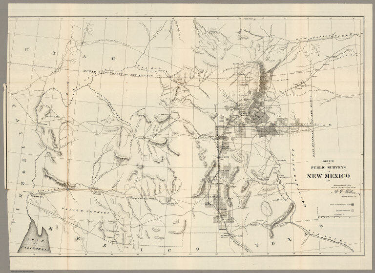
Full Title
Sketch of Public Surveys in New Mexico 1861. Surveyor Generals Office, Santa Fe, New Mexico, July 12th.1861. A. P. Wilbar, Surveyor General of N. M.
List No
1076.004
Note
Five issues (1855,57,60,61,63) from the Annual Reports.Uncolored map. Relief shown by hachures. Shows private and public claims surveyed, and Townships subdivided.
Author
U.S. General Land Office
Full Title
A Diagram of Oregon. Surveyor General's Office, Eugene City, August 16th, 1861. B J Pengra;, Sur. Genl. of Oregon. Lith of J. Bien. (to accompany ten issues of) A Diagram of Oregon (1851,52,55,58,59,60,61,63,64).
List No
1077.006
Note
Uncolored map. Nine issues from the Annual Reports. Relief shown by hachures. Shows townships surveyed and proposed to be surveyed. Includes explanations of symbols used on map. In upper right corner: Sen. Ex.: Doc. No. 1. 37th. Cong. 2nd. Sess.
Author
U.S. General Land Office
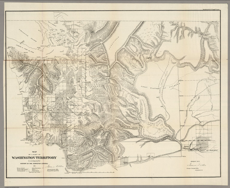
Full Title
Map of a Part of Washington Territory : to Accompany the Report of the Surveyor General 1861. James Tilton, Surveyor General Office. Olympia W.T. Sept. 9th., 1861. Sheet No. 2. James Tilton Surveyor General's Office, Olympia, W.T.
List No
1079.007
Note
Eleven issues, from the Annual Reports. (1855,57,57,58,59,60,61,62,63, 65,76). (Titles vary). Without color. Relief shown by hachures. In upper right corner: Sen. Ex. Doc. No. 1. 37th. Cong. 2nd. Sess. Shows roads, trails, Indian reservations, lands surveyed and proposed to be surveyed, and Puget Sound Co's claims.
Author
Farmer, John, 1798-1859
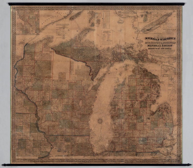
Full Title
Map of the states of Michigan and Wisconsin : embracing a great part of Iowa, Illinois & Minnesota; and the whole mineral region, with charts of the lakes; exhibiting the sections, the soundings, the geological formations and the general topography. Compiled from the topographical departments, from the Office of the United States Lake Surveys, from the latest geological and linear surveys, and from various authentic and reliable sources ; projected, engraved by John Farmer, C. E. Detroit, Michigan. Published by R. Farmer & Co. 1861. (7 insets). Entered according to act of Congress ... 29th day of September, A.D. 1858 ... And reentered ... 21st day of Janu. A.D. 1861 by R. Farmer and Co.
List No
11273.000
Note
This may be the only large wall map that Farmer made. Outline hand color wall map. With 7 insets: Geological map of part of Minnesota. (with) Map and profile of Canal at Sault Ste. Mary. (with) Map of Beaver Isles. (with) A geological map of Isle Royale, Lake Superior. (with) Connection of the private claims with the public surveys at Ptc. Ste. Ignace. (with) Chart of Port Colier. (with) Chart of Detroit River. Relief shown by hachures, shadings and spot heights. Bathymetry shown by soundings in feet. Shows state boundaries, swamp lands, Indian reservations, cities and towns. Includes: Geological references for Wisconsin, Iowa and Minnesota, Reference table, Census of Michigan counties for 1837-1860 and text.
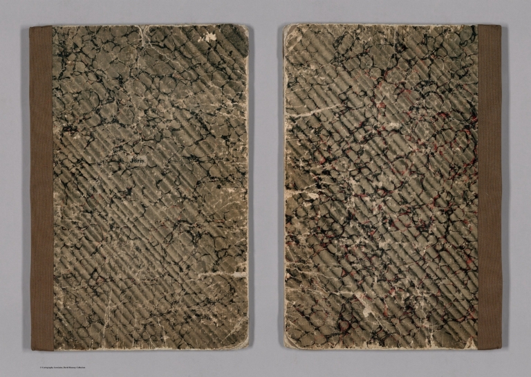
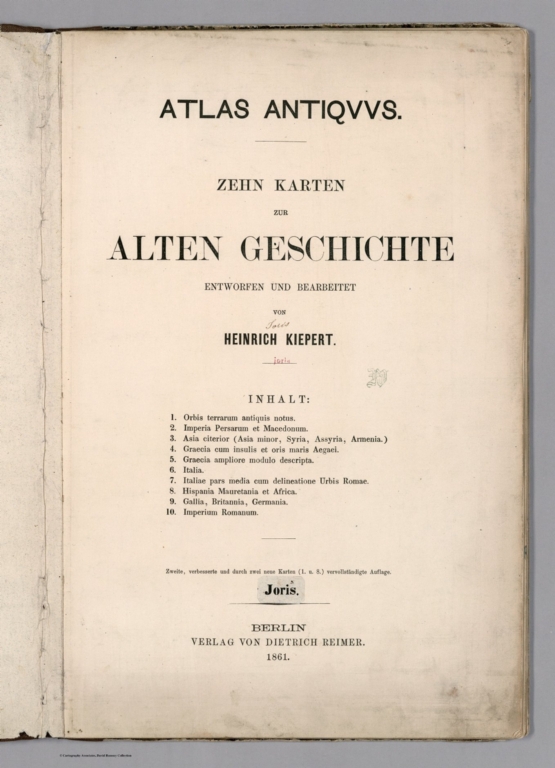
Author
Kiepert, Heinrich, 1818-1899
Full Title
(Covers to) Atlas antiquus : zehn karten zur alten geschichte. Entworfen und bearbeitet von Heinrich Kiepert. zweite, verbesserte und durch zwei neue karten (1. u. 8.) vervollstandigte Auflage. Berlin: Verlag von Dietrich Reimer. 1861.
List No
11688.001
Note
Second, improved edition with two new maps (1st and 8th), Kiepert's Ancient atlas, with title page and 10 folded maps. Published in 1861 by Dietrich Reimer. Title page in German and maps in Latin. Maps are colored, showing political and administrative boundaries, major cities, towns, roads, rivers, canals and mountains. Relief shown by hachures. Prime meridians are Paris and Greenwich. Bound in brown marbled paper with black lettering "Joris" pasted on cover. Geographer Heinrich Kiepert (1818-1899) is generally considered to be one of the most important scholarly cartographers of the second half of the 19th century.
Author
Kiepert, Heinrich, 1818-1899
Full Title
(Title Page to) Atlas antiquus : zehn karten zur alten geschichte. Entworfen und bearbeitet von Heinrich Kiepert. zweite, verbesserte und durch zwei neue karten (1. u. 8.) vervollstandigte Auflage. Berlin: Verlag von Dietrich Reimer. 1861.
List No
11688.002
Note
Second, improved edition with two new maps (1st and 8th), Kiepert's Ancient atlas, with title page and 10 folded maps. Published in 1861 by Dietrich Reimer. Title page in German and maps in Latin. Maps are colored, showing political and administrative boundaries, major cities, towns, roads, rivers, canals and mountains. Relief shown by hachures. Prime meridians are Paris and Greenwich. Bound in brown marbled paper with black lettering "Joris" pasted on cover. Geographer Heinrich Kiepert (1818-1899) is generally considered to be one of the most important scholarly cartographers of the second half of the 19th century.
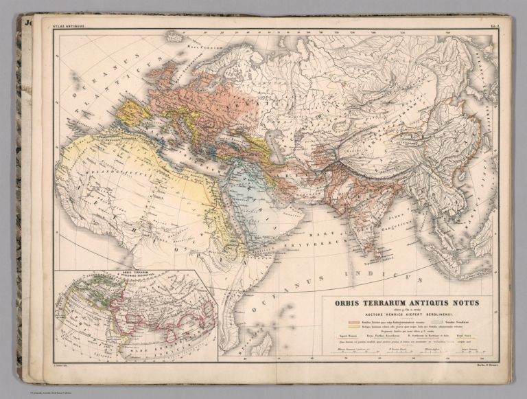
Author
Kiepert, Heinrich, 1818-1899
Full Title
Orbis terrarum antiquis notus : altero p. Chr. saeculo antiquis notus. Auctore Henrico Kiepert Berolinensi. J. Sulzer lith. Berlin. D. Reimer. (to accompany) Atlas antiquus : zehn karten zur alten geschichte ... 1861. (inset) Orbis Terrarum Ptolemaeo descriptus.
List No
11688.003
Note
Color map of the ancient world. Color coded by regions. Relief shown by hachures.
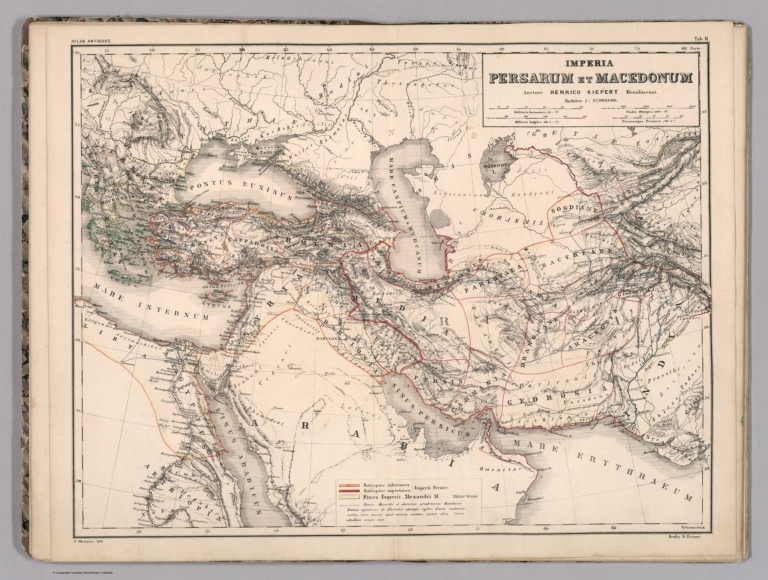
Author
Kiepert, Heinrich, 1818-1899
Full Title
Imperia Persarum et Macedonum. Auctore Henrico Kiepert Berolinensi. C. Ohmann lith. Berlin. D. Reimer. (to accompany) Atlas antiquus : zehn karten zur alten geschichte ... 1861.
List No
11688.004
Note
Outline color map of Persian Empire and Macedonia. Relief shown by hachures. Prime meridians are Paris and Greenwich.
Author
Kiepert, Heinrich, 1818-1899
Full Title
Asia citerior. Auctore Henrico Kiepert Berolinensi. L. Kraatz lith. Berlin. D. Reimer. (to accompany) Atlas antiquus : zehn karten zur alten geschichte ... 1861.
List No
11688.005
Note
Outline color. Relief shown by hachures. Prime meridians are Paris and Greenwich. Includes legend and notes.
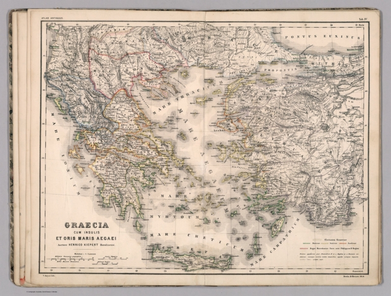
Author
Kiepert, Heinrich, 1818-1899
Full Title
Graecia cum insulis et oris maris Aegaei. Auctore Henrico Kiepert Berolinensi. V. Geyer lith. Berlin. D. Reimer. 1858. (to accompany) Atlas antiquus : zehn karten zur alten geschichte ... 1861.
List No
11688.006
Note
Outline color. Relief shown by hachures. Prime meridians are Paris and Greenwich. Includes legend and notes.
Author
Kiepert, Heinrich, 1818-1899
Full Title
Graecia. Auctore Henrico Kiepert Berolinensi. V. Geyer lith. Berlin. D. Reimer. 1858. (to accompany) Atlas antiquus : zehn karten zur alten geschichte ... 1861. (insets) Athenae. (with: Athens and surroundings).
List No
11688.007
Note
Outline hand colored map by region. Relief shown by hachures. Prime meridians are Paris and Greenwich.
Author
Kiepert, Heinrich, 1818-1899
Full Title
Italia. Auctore Henrico Kiepert Berolinensi. L. Kraatz lith. Berlin D. Reimer. (to accompany) Atlas antiquus : zehn karten zur alten geschichte ... 1861. (insets) Undecim regiones Italiae ab Augusto Imp. institutae.
List No
11688.008
Note
Outline hand colored map by administrative divisions. Relief shown by hachures. Prime meridians are Paris and Greenwich.
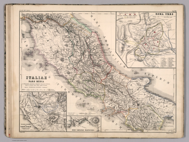
Author
Kiepert, Heinrich, 1818-1899
Full Title
Italiae pars media. ad illustrandum potissimum antiquiorem Romanorum historiam duplici ad tabulam totius Italiae modulo descripta. Auctore Henrico Kiepert Berolinensi. J. Sulzer. lith. Berlin D. Reimer. (to accompany) Atlas antiquus : zehn karten zur alten geschichte ... 1861. (insets) Roma Urbs. (with) Reciones proximae circa Urbem Romam. (with) Regio campaniae Neapolitana.
List No
11688.009
Note
Outline hand colored map by administrative divisions. Relief shown by hachures. Prime meridians are Paris and Greenwich.
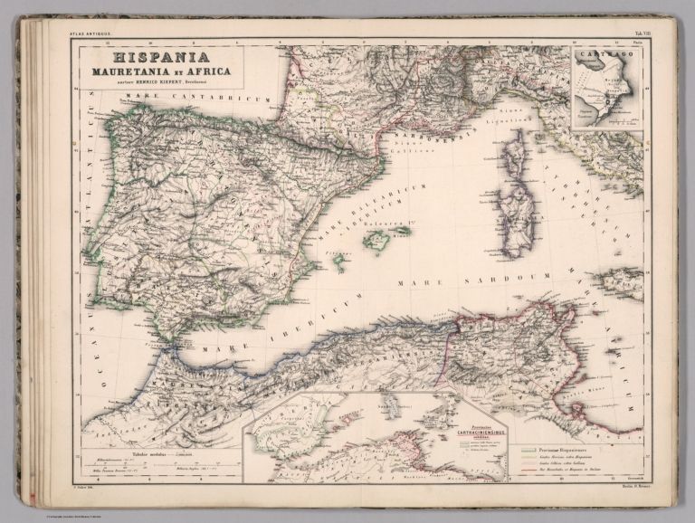
Author
Kiepert, Heinrich, 1818-1899
Full Title
Hispania, Mauretania et Africa. Auctore Henrico Kiepert Berolinensi. J. Sulzer. lith. Berlin D. Reimer. (to accompany) Atlas antiquus : zehn karten zur alten geschichte ... 1861. (insets) Carthago. (with) Provinciae Carthaginensibus subditae.
List No
11688.010
Note
Outline hand colored map by political divisions. Relief shown by hachures. Prime meridians are Paris and Greenwich. Includes legend.
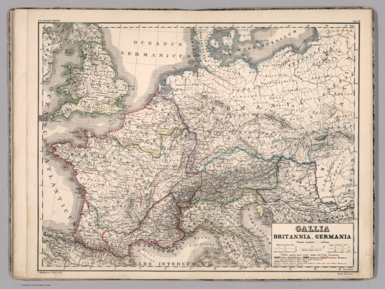
Author
Kiepert, Heinrich, 1818-1899
Full Title
Gallia, Britannia, Germania. C. Ohmann et J. Sulzer. lith. Berlin D. Reimer. (to accompany) Atlas antiquus : zehn karten zur alten geschichte ... 1861.
List No
11688.011
Note
Outline hand colored map by political divisions. Covers United Kingdom, France and Germany. Relief shown by hachures. Prime meridians are Paris and Greenwich. Includes legend.
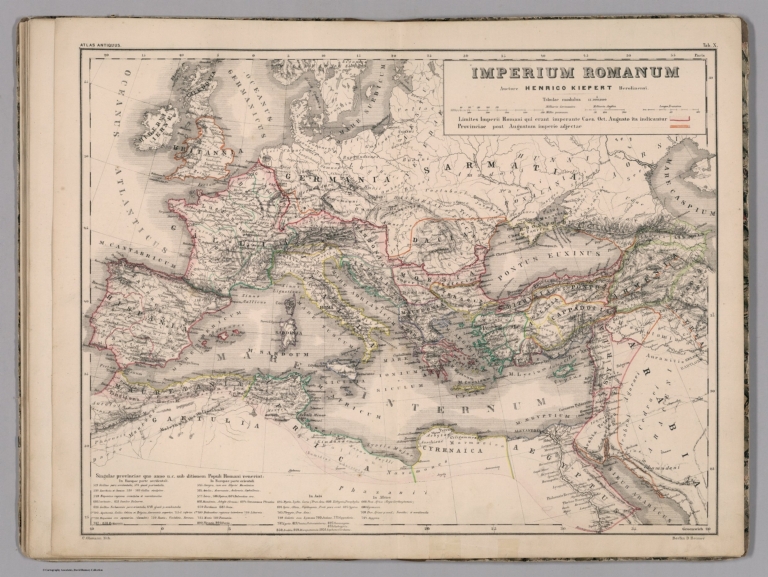
Author
Kiepert, Heinrich, 1818-1899
Full Title
Imperium Romanum. Auctore Henrico Kiepert Berolinensi. C. Ohmann lith. Berlin D. Reimer. (to accompany) Atlas antiquus : zehn karten zur alten geschichte ... 1861.
List No
11688.012
Note
Outline hand colored map of ancient Roman Empire. Relief shown by hachures. Prime meridians are Paris and Greenwich. Includes legend and notes.
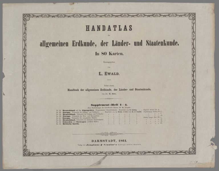
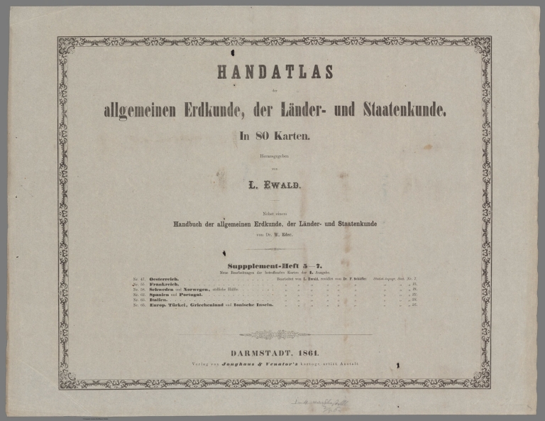
Ewald, Ludwig 1813-1881; Bauerkeller, Ge... Section Title Page: Handatlas der Allgem... 1861 12189.115 Related Author
[Ewald, Ludwig 1813-1881, Bauerkeller, Georg Leonhart]
Full Title
(Section Title Page) Handatlas der Allgemeinen Erdkunde, Laender- und Staatenkunde, In 80 Karten. Herausgegeben von L. Ewald ... Nebst einem Handbuch der allgemeinen Erdkunde. Laender- und Staatenkunde von Dr. E. Eder. Supplement-Heft 1-4 ... Darmstadt, 1861.
List No
12189.115
Author
[Ewald, Ludwig 1813-1881, Bauerkeller, Georg Leonhart]
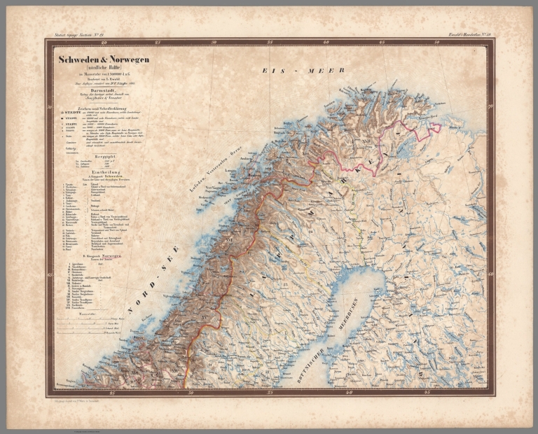
Full Title
No. 59. Schweden und Norwegen.
List No
12189.122
Ewald, Ludwig 1813-1881; Bauerkeller, Ge... Section Title Page: Handatlas der Allgem... 1861 12189.124 Related Author
[Ewald, Ludwig 1813-1881, Bauerkeller, Georg Leonhart]
Full Title
(Section Title Page) Handatlas der Allgemeinen Erdkunde, Laender- und Staatenkunde, In 80 Karten. Herausgegeben von L. Ewald ... Nebst einem Handbuch der allgemeinen Erdkunde. Laender- und Staatenkunde von Dr. E. Eder. Supplement-Heft 5-7 ... Darmstadt, 1861.
List No
12189.124
Author
[Ewald, Ludwig 1813-1881, Bauerkeller, Georg Leonhart]
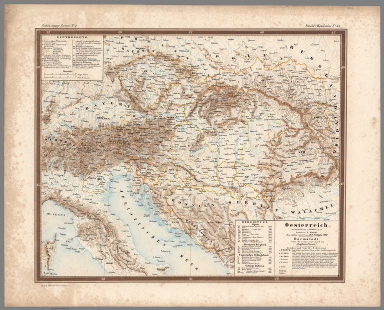
Full Title
No. 47. Oesterreich.
List No
12189.125
Author
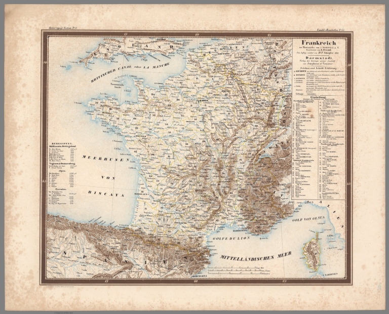
[Ewald, Ludwig 1813-1881, Bauerkeller, Georg Leonhart]
Full Title
No. 55. Frankreich.
List No
12189.126
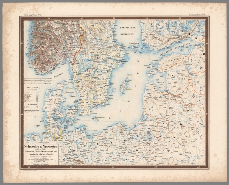
Ewald, Ludwig 1813-1881; Bauerkeller, Ge... No. 58. Schweden und Norwegen, (suedkich... 1861 12189.127 Related Author
[Ewald, Ludwig 1813-1881, Bauerkeller, Georg Leonhart]
Full Title
No. 58. Schweden und Norwegen, (suedkiche Haelfte), Daenemark, Nord - Deutschland und russusche Ostsee - Lander.
List No
12189.127
Author
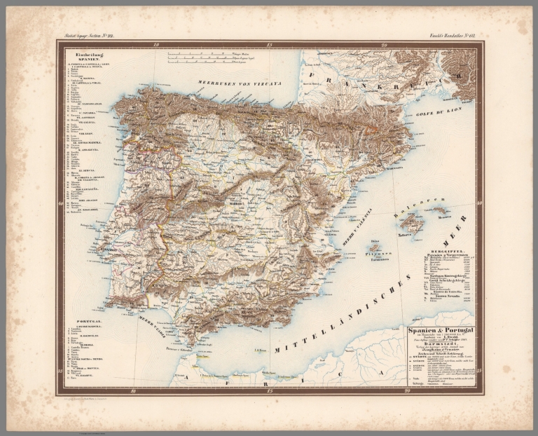
[Ewald, Ludwig 1813-1881, Bauerkeller, Georg Leonhart]
Full Title
No. 62. Spanien und Portugal.
List No
12189.128
Author
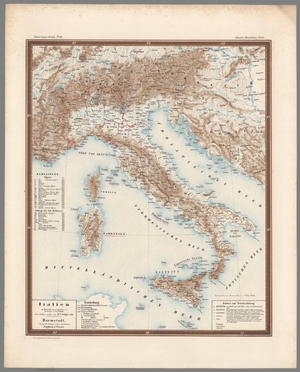
[Ewald, Ludwig 1813-1881, Bauerkeller, Georg Leonhart]
Full Title
No. 63. Italien.
List No
12189.129
Ewald, Ludwig 1813-1881; Bauerkeller, Ge... No. 65. Die Europaeische Tuerkel, Griech... 1861 12189.130 Related Author
[Ewald, Ludwig 1813-1881, Bauerkeller, Georg Leonhart]
Full Title
No. 65. Die Europaeische Tuerkel, Griechenland und Ionische Inseln.
List No
12189.130
Author
Wyld, James, 1812-1887
Full Title
(Covers to) Wyld's Military Map Of The United States, The Northern States, And The Southern Confederate States: With The Forts, Harbours, Arsenals And Military Positions. James Wyld, 457 Strand; Charing Cross East And 2, Royal Exchange London. London, Published By James Wyld, Geographer To The Queen & H.R.H. The Prince Consort ... (with 4 inset maps).
List No
1246A
Author
Wyld, James, 1812-1887
Full Title
Wyld's Military Map Of The United States, The Northern States, And The Southern Confederate States: With The Forts, Harbours, Arsenals And Military Positions. James Wyld, 457 Strand; Charing Cross East And 2, Royal Exchange London. London, Published By James Wyld, Geographer To The Queen & H.R.H. The Prince Consort ... (with 4 inset maps).
List No
1246.001
Note
Stephenson copy is dated 1861; this is undated. Excellent detail, several insets. Chippewa is a state above Dakotah. Paste down advertising catalogue for maps, atlases and globes. Inset maps include: City Of Washington And District Of Columbia, Country Round Washington, Pensacola Bay and its Fortifications, Charleston And The Harbour. Map is dissected into 25 sections and mounted on linen. Outline color by state and military position. Map folds into brown cloth covered boards 21.5x13.5 with a paste down label reading "Wyld's New Map Of The United States. James Wyld, Geographer To The Queen, & H.R.H. The Prince Consort, 457, Strand, Charing Cross East, S.W. Opposite Northumberland Street; And 2, Royal Exchange, E.C. London." A remnant of a label on the spine appears to read "United States".
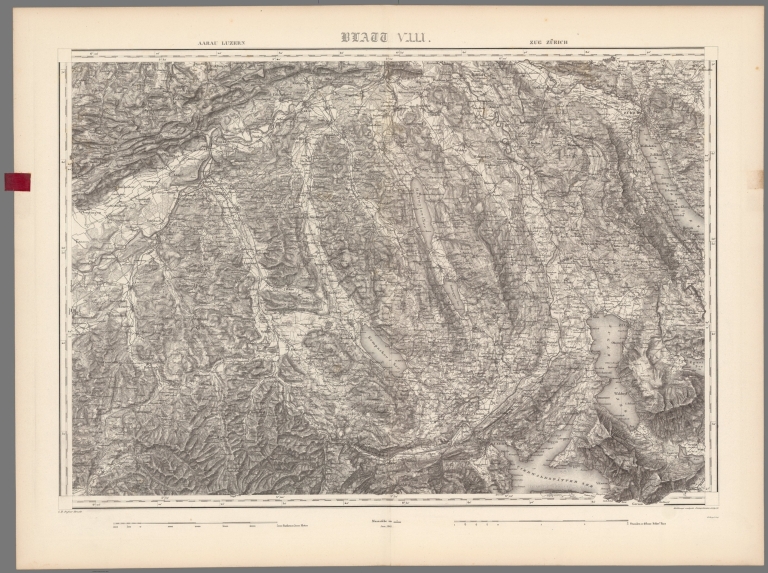
Dufour, Guillaume Henri, 1787-1875 Blatt VIII. Aarau - Lucerne - Zug - Zuri... 1861 13220.009 Related Author
Dufour, Guillaume Henri, 1787-1875
Full Title
Blatt VIII. Aarau - Lucerne - Zug - Zurich. G.H. Dufour direxit. Bressanini et Mullhaupt sc H. Koegel, imp. (to accompay) Topographische Karte der Schweiz ... G. H. Dufour. 1833-1863.
List No
13220.009
Note
Sheet 8. Relief shown by hachures and spot heights. Depth shown by isolines and soundings. Depth shown by isolines and soundings.
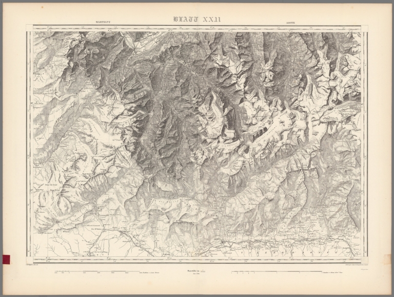
Author
Dufour, Guillaume Henri, 1787-1875
Full Title
Blatt XXII. Martigny - Aoste. G.H. Dufour direxit. Ann. 1861. Bressanini et Mullhaupt sc. H. Koegel, imp. (to accompay) Topographische Karte der Schweiz ... G. H. Dufour. 1833-1863.
List No
13220.023
Note
Sheet 22. Relief shown by hachures, formlines and spot heights.
Author
Vuillemin, Alexandre
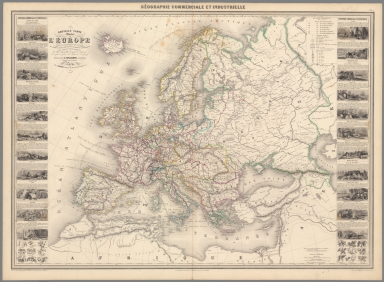
Full Title
Geographie commerciale et industrielle : Nouvelle carte illustree de l'Europe : presentant les grandes divisions physiques, la distribution geographique des vegetaux et des mineraux, les villes industrielles, les ports de commerce, les places fortes, les chemins de fer & a. Dressee par A. Vuillemin. Gravee par Langevin. Paris, Chez Fatout, Editeur. 1861. Grave sur acier, la topographie par Gerin, le trait au burin par F. Lefevre, Les illustrations dessinees par A. Testard et gravees par Guesnu. Imprime par Mangeon. Paris. (to accompany) Atlas illustre de geographie commerciale et industrielle.
List No
13376.006
Note
Engraved outline hand color new map of Europe. Includes 22 vignettes views of the industrial cities and the commercial ports and 2 sections of fruits and plants.
Author
Vuillemin, Alexandre
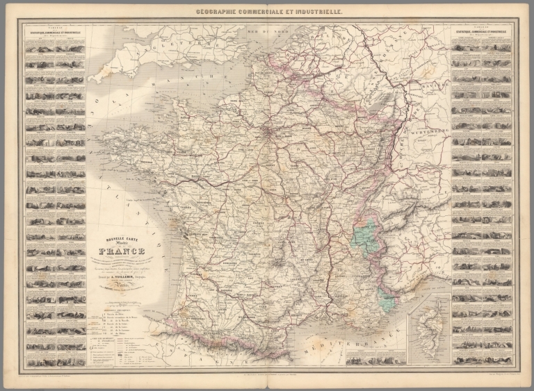
Full Title
Geographie commerciale et industrielle : Nouvelle carte illustree de la France : presentant les divisions physiques, la distribution geographique des plantes cultivees, la division territoriale comparative des anciennes provinces et des departements actuels. les usines importantes, les principales mines exploitees, les canaux, les chemins de fer & a. Dressee par A. Vuillemin. Gravee par Langevin. Paris, Chez Fatout, Editeur. 1861. Grave sur acier, la topographie par Gerin, le trait au burin par F. Lefevre, Les illustrations dessinees par A. Testard et gravees par Guesnu. Imprime par Mangeon. Paris. (to accompany) Atlas illustre de geographie commerciale et industrielle.
List No
13376.007
Note
Engraved outline hand color map of France, with inset: Corse. Shows administrative divisions, the comparative territorial division of the former provinces and current departments, mines, canals, railways and factories. Includes vignette views of different provinces and departments. Includes legend, tables and notes.
Author
Vuillemin, Alexandre
Full Title
Geographie commerciale et industrielle : Nouvelle Carte Illustree des Royaumes de Hollande et the Belgique : Presentant la Geographie Physique, la Distribution Generale des Plantes Cultivees, les villes commerçantes et manufacturieres les usines importantes, les mines de houille exploitées les principales routes les chemins de fer et les canaux. Dressee par A. Vuillemin. Gravee par Langevin. Paris, Chez Fatout, Editeur. 1861. Grave sur acier, la topographie par Gerin, le trait au burin par F. Lefevre. Les Eaux Gravees a la Mecanique par Mme. Fontaine Les illustrations dessinees par A. Testard et gravees par Guesnu. Imprime par Mangeon. Paris. (to accompany) Atlas illustre de geographie commerciale et industrielle.
List No
13376.008
Note
Engraved outline hand color map, with 21 vignettes views of the industrial cities and the commercial ports. Showing Physical Geography, General Distribution of Cultivated Plants, trading and manufacturing towns, important factories, coal mines, roads, railways and canals. Includes legend, tables and notes.
Author
Vuillemin, Alexandre
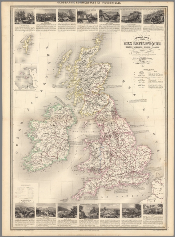
Full Title
Geographie commerciale et industrielle : Nouvelle Carte Illustree des Isles Britanniques (Grande Bretagne, Ecosse, Irlande) : Presentant les Divisions Territoriales et Physiques, la Distribution geographique des Plantes Cultivees, les villes industrielles, les ports commerciaux, les mines exploitees les chemins de fer, les routes et les canaux. Dressee par A. Vuillemin. Gravee par Langevin. Paris, Chez Fatout, Editeur. 1861. Grave sur acier, la topographie par Gerin, le trait au burin par F. Lefevre. Les Eaux Gravees a la Mecanique par Mme. Fontaine Les illustrations dessinees par A. Testard et gravees par Guesnu. Imprime par Mangeon. Paris. (to accompany) Atlas illustre de geographie commerciale et industrielle.
List No
13376.009
Note
Engraved outline hand color map, Insets: Iles Shetland; Iles Anglo Normandes. Includes 14 vignettes views of the industrial cities and the commercial ports. Showing Physical Geography, General Distribution of Cultivated Plants, trading and manufacturing towns, important factories, coal mines, roads, railways and canals. Includes legend, tables and notes.
Author
Vuillemin, Alexandre
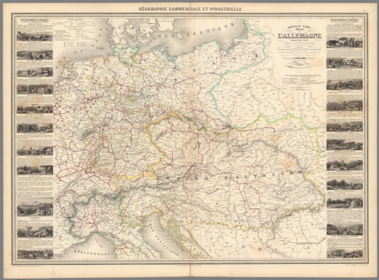
Full Title
Geographie commerciale et industrielle : Nouvelle Carte Illustree de l'Allemagne : Donnant les Etats Composant la Confederetion Germanique Indiquant les Divisions Physiques et Territoriales, la Distribution Geographique des Plants Cultivees, les villes industrielles, les ports commerciaux les chemins de fer, les routes et des canaux. Dressee par A. Vuillemin. Gravee par Langevin. Paris, Chez Fatout, Editeur. 1861. Grave sur acier, la topographie par Gerin, le trait au burin par F. Lefevre. Les illustrations dessinees par A. Testard. Imprime par Mangeon. Paris. (to accompany) Atlas illustre de geographie commerciale et industrielle.
List No
13376.011
Note
Engraved outline hand color map of Germany and the Austrian Empire. Including 22 vignettes views. Showing administrative and political divisions. Includes legend, tables and notes.
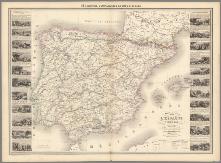
Author
Vuillemin, Alexandre
Full Title
Geographie commerciale et industrielle : Nouvelle Carte Illustree de L'Espagne et de Portugal : Presentant les Divisions Politiques et Physiques la distribution geographique des plantes cultivees ... Dressee par A. Vuillemin. Gravee par Langevin. Paris, Chez Fatout, Editeur. 1861. Grave sur acier, Grave: la Topographie par Gerin, le trait au burin par F. Lefevre. Les illustrations dessinees par A. Testard et gravees par Guesnu. Imprime par Mangeon. Paris. (to accompany) Atlas illustre de geographie commerciale et industrielle.
List No
13376.014
Note
Engraved outline hand color map. Including 22 vignettes views . Showing administrative and political divisions. Includes legend, tables and notes.
Author
Vuillemin, Alexandre
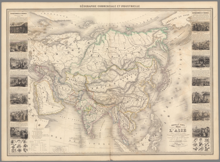
Full Title
Geographie commerciale et industrielle : Nouvelle Carte Illustree de l'Asie : indiquant les grandes division physiques, la distribution geographique des veget́aux et des mineŕaux ... Dressee par A. Vuillemin. Gravee par Langevin. Paris, Chez Fatout, Editeur. 1861. Grave sur acier, Grave: la Topographie par Gerin, le trait au burin par F. Lefevre. Les illustrations dessinees par A. Testard et gravees par Guensu. Imprime par Mangeon. Paris. (to accompany) Atlas illustre de geographie commerciale et industrielle.
List No
13376.016
Note
Engraved outline hand color map. Including 14 vignettes views of different countries in Asia and 2 sections of fruits and plants in panels at sides. Showing political divisions. Includes legend, tables and notes.
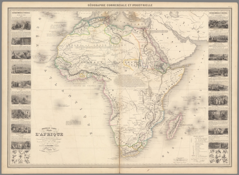
Author
Vuillemin, Alexandre
Full Title
Geographie commerciale et industrielle : Nouvelle Carte Illustree de l'Afrique : presentant les grandes division physiques, la distribution geographique des veget́aux et des mineŕaux ... Dressee par A. Vuillemin. Gravee par Langevin. Paris, Chez Fatout, Editeur. 1861. Grave sur acier, Grave: la Topographie par Gerin, le trait au burin par F. Lefevre. Les illustrations dessinees par A. Testard et gravees par Guensu. Imprime par Mangeon. Paris. (to accompany) Atlas illustre de geographie commerciale et industrielle.
List No
13376.017
Note
Engraved outline hand color map. Including 18 vignettes views of different countries and regions in Africa and 2 sections of fruits and plants in panels at sides. Showing political divisions. Includes legend, tables and notes.
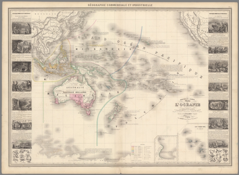
Author
Vuillemin, Alexandre
Full Title
Geographie commerciale et industrielle : Nouvelle carte illustree de l'Oceanie presentant les grandes divisions physiques la distribution geographique des vegetaux et des mineraux ... Dressee par A. Vuillemin. Gravee par Langevin. Paris, Chez Fatout, Editeur. 1861. Grave sur acier, Grave: la Topographie par Gerin, le trait au burin par F. Lefevre. Les illustrations dessinees par A. Testard et gravees par Guensu. Imprime par Mangeon. Paris. (to accompany) Atlas illustre de geographie commerciale et industrielle.
List No
13376.018
Note
Engraved outline hand color map. Insets: Terre Victoria; Iles Nouka-Hiva ou Iles Marquises (a la France). Including 14 vignettes views of different countries and 2 sections of fruits and plants in panels at sides. Includes legend, tables, color coded table of European colonies in the region and notes.
Author
Lapie, Pierre
Full Title
A map of the United States and Canada, New-Scotland, New-Brunswick and New-Foundland = Carte des Etats-Unis avec le Canada, la Nouvelle Ecosse, le Nouveau Brunswick & Terre-Neuve. Dressee par Lapie. Publiee par Auguste Logerot. Paris. Mangeon imp. Paris.
List No
13398.001
Author
Andriveau-Goujon, Eugene
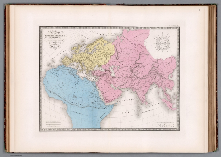
Full Title
Carte generale du monde ancien, representant l'ensemble des connaissances geographiques des grecs et des romains. Publiee par J. Andriveau-Goujon, Rue du Bac, no. 21, Paris, 1861 . Paris, impie de Louis Antoine. (to accompany) Atlas classique et universel de geographie ancienne et moderne ... Nouvelle edition. 1863.
List No
13421.009
Note
Hand color map. Relief shown by hachures. Prime meridian: Paris. Includes a wind rose.
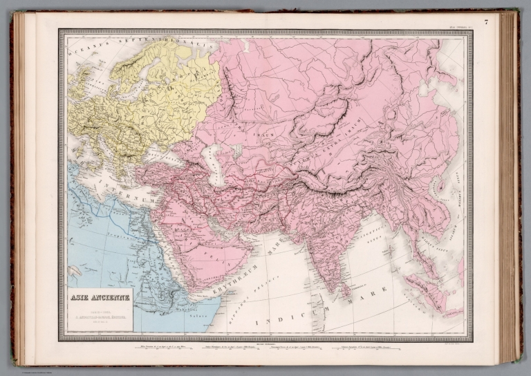
Author
Andriveau-Goujon, Eugene
Full Title
Asie ancienne. Paris - 1861 - J. Andriveau-Goujon, Rue du Bac, no. 21, Editeur. Impie de Louis Antoine. (to accompany) Atlas classique et universel de geographie ancienne et moderne ... Nouvelle edition. 1863.
List No
13421.010
Note
Hand color map Asia and part of Africa. Relief shown by hachures. Prime meridian: Paris. Includes a wind rose.
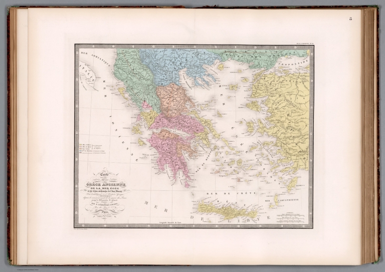
Author
Andriveau-Goujon, Eugene
Full Title
Carte de la Grece ancienne, de la Mer Egee et des cotes occidentales de l'Asie Mineure, pour l'intelligence de l'histoire grecque, principalement depuis le commencement de la guerre des Perses jusqu'a Alexandre le Grand. Publiee par J. Andriveau-Goujon, Rue du Bac, no. 21, 1861. Paris, Impie de Louis Antoine. (to accompany) Atlas classique et universel de geographie ancienne et moderne ... Nouvelle edition. 1863.
List No
13421.011
Note
Hand color map ancient Greece and part of Turkey. Relief shown by hachures. Prime meridian: Paris.
Author
Andriveau-Goujon, Eugene
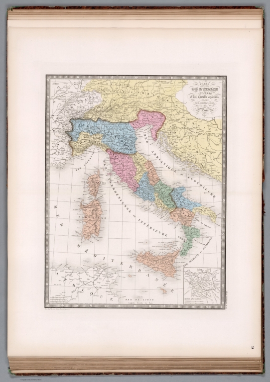
Full Title
Carte de l'Italie ancienne et des contrees adjacentes. Publiee par J. Andriveau-Goujon, Rue du Bac, no. 21, Paris. 1861. Paris, Impie de Louis Antoine. (to accompany) Atlas classique et universel de geographie ancienne et moderne ... Nouvelle edition. 1863.
List No
13421.012
Note
Hand color map ancient Italy, with inset map: Rome ancienne. Relief shown by hachures. Prime meridian: Paris.
Author
Andriveau-Goujon, Eugene
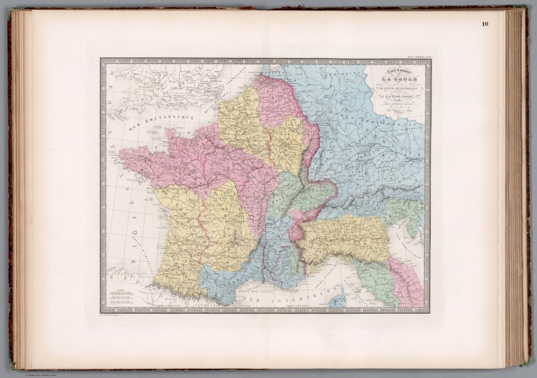
Full Title
Carte comparee de la Gaule : divisee en 17 provinces romaines, de l'Italie septentrionale et d'une partie de la Grande Germanie. Publiee par J. Andriveau-Goujon, Rue du Bac, no. 21, Paris. 1861. Paris, Impie de Louis Antoine. (to accompany) Atlas classique et universel de geographie ancienne et moderne ... Nouvelle edition. 1863.
List No
13421.013
Note
Hand color map. Relief shown by hachures. Prime meridian: Paris.
Author
Andriveau-Goujon, Eugene
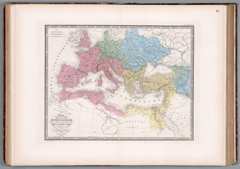
Full Title
Carte de l'Empire Romain. Depuis Constantin jussqu'a la fin du 4e. Siecle. Publiee par J. Andriveau-Goujon, Rue du Bac, no. 6, Paris. 1861. Paris, Impie de Louis Antoine. (to accompany) Atlas classique et universel de geographie ancienne et moderne ... Nouvelle edition. 1863.
List No
13421.014
Note
Hand color map of Roman Empire. Relief shown by hachures. Prime meridian: Paris.
Author
Andriveau-Goujon, Eugene
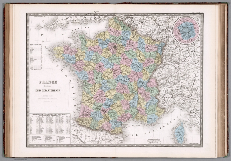
Full Title
France divisee en 89 departemens. Paris - 1861. E. Andriveau-Goujon, Editeur. Rue du Bac. 21. La lettre par P. Rousset. Imp. Louis Antonie. (to accompany) Atlas classique et universel de geograparphie ancienne et moderne ... Nouvelle edition. 1863.
List No
13421.028
Note
Hand color map, with inset: Banlieue de Paris. Shows administrative boundaries. Relief shown by hachures. Includes legend, tables of population and main basins. Prime meridian: Paris. France Department: marked on the upper right margin, No. 22, but hand written title on verso marked 21. Added to the atlas and bound before France provinces, also marked 21 (21A).
|