|
Author
Arrowsmith, John, 1790-1873
Full Title
(Covers to) The London atlas, 1861.
List No
14506.001
Note
Covers to The London atlas of universal geography. Bound in black leather with gilt title, border, and spine title.
Author
Arrowsmith, John, 1790-1873
Full Title
(Title Page to) The London atlas of universal geography, exhibiting the physical & political divisions of the various countries of the world, constructed from original materials. Is most respectfully dedicated to his venerable friends John Middleton Esqr. as a testimony of gratitude and esteem, by his much obliged & humble servant, John Arrowsmith, F.R.G.S. & R.A.S. 10, Soho Square, London. London, pubd. by J. Arrowsmith, 10 Soho Square, 1858.
List No
14506.002
Note
Title page to The London atlas of universal geography.
Author
Arrowsmith, John, 1790-1873
Full Title
(Contents to) Contents.
List No
14506.003
Note
Manuscript table of contents to The London atlas of universal geography. Lists maps by title with associated plate numbers.
Author
Arrowsmith, John, 1790-1873
Full Title
The world, on Mercator's projection, by John Arrowsmith. London, pubd. Augt. 22nd. 1861, by J. Arrowsmith, 10 Soho Square.
List No
14506.008
Note
Composite world map. Shows countries, regions and cities, topography, bodies of water, drainage, deserts, coastlines and islands. Relief shown with hachures. Features exploration routes with names of explorers and dates of their voyages. Includes latitudinal and longitudinal lines. Descriptive notes throughout. With two inset maps: [South Pole] -- [North Pole]. Hand-colored engraving. All together, map is 64 x 109 cm, on two double sheets, together 68 x 112 cm.
Author
Arrowsmith, John, 1790-1873
Full Title
The inland navigation, rail roads, geology, and minerlas of England & Wales, by J. Arrowsmith. London, pubd. 15 Feby. 1842, by J. Arrowsmith, 10 Soho Square.
List No
14506.011
Note
Map representing England and Wales. Shows counties, cities, railways, topography, bodies of water, drainage, coastlines and islands. Relief shown with hachures. Includes a legend, table of geological groups, lines of navigation, and latitudinal and longitudinal lines, as well as bar scales given in geographical and English miles. Hand-colored engraving. Map is 63 x 50 cm, on double sheet 68 x 56 cm.
Author
Arrowsmith, John, 1790-1873
Full Title
Official map of railways in England and Scotland, shewing the existing lines & those in progress; from the maps prepared, by the authority of the Commissioners of Railways; (presented to both houses of parliament) and from the other documents; by John Arrowsmith. 1858. London, pubd. July 1st, 1858, by J. Arrowsmith, 10 Soho Square.
List No
14506.014
Note
Composite map of railways in England and Scotland. Shows counties, cities, railways, bodies of water, drainage, coastlines and islands. Relief shown with hachures. Includes a legend, latitudinal and longitudinal lines, as well as a bar scale given in English miles. Hand-colored engraving. Hand-colored engraving. All together, map is 106 x 67 cm, on two double sheets, together 68 x 112 cm.
Author
Arrowsmith, John, 1790-1873
Full Title
Southern portion of the Crimea, from surveys made by order of the Russian government. John Arrowsmith, 10 Soho Square. London. Pubd. 6th June 1854, by John Arrowsmith, 10 Soho Square.
List No
14506.028
Note
Map representing the southern part of Crimea. Shows political boundaries, cities, roads, topography, bodies of water, drainage, coastlines and islands. Relief shown with hachures. Includes latitudinal and longitudinal lines, as well as bar scales given in English miles and Russian versts. Includes informational text throughout. With two inset maps: [Black Sea.] -- Sebastapol inlet & harbour from Russian survey. Hand-colored engraving. Map is 61 x 78 cm, on fold-out sheet 68 x 84 cm.
Author
Arrowsmith, John, 1790-1873
Full Title
Map of the Ionian Islands and Malta : Compiled from surveys & original documents in the colonial office, the ordnance department &c by John Arrowsmith. London. Pubd. 8th. August. 1858, by John Arrowsmith, 10 Soho Square.
List No
14506.036
Note
Map representing the Ionian Islands of Greece, and Malta. Shows political boundaries, cities, roads, topography, bodies of water, drainage, coastlines, and islands. Relief shown with hachures. Includes latitudinal and longitudinal lines, as well as a bar scale given in English miles. With informational text and three ancillary maps: [Cerigo.] -- Map of the Maltese Islands from actual surveys. -- [Map of sailing routes between Cairo, Malta, Ionian Islands, London, and various points in Europe]. Hand-colored engraving. Map is 62 x 53 cm, on double sheet 68 x 56 cm.
Author
Arrowsmith, John, 1790-1873
Full Title
(Composite map of) Map of the West coast of Africa comprising Guinea, and the British possessions at Sierra Leone, on the Gambia and the Gold Coast, together with the countries within the courses of the rivers Senegal, Gambia & Kowara, compiled from official documents, by J. Arrowsmith, 1858. London. Pubd. 17th April 1858, by John Arrowsmith, 10 Soho Square.
List No
14506.042
Note
Composite map representing West Africa. Shows political boundaries, cities, roads, topography, deserts, bodies of water, drainage, coastlines, and islands. Relief shown with hachures. Includes latitudinal and longitudinal lines. Hand-colored engraving.
Author
Arrowsmith, John, 1790-1873
Full Title
Madagascar, from original drawings, sketches, diaries & oral information; by J.A. Lloyd Esqre. F.R.S., F.R.G.S. &c. &c. Survr. Genl. of the Maurituus. John Arrowsmith 10 Soho Square, 1850. Lond. Pubd. Feby. 5th. 1850. by John Arrowsmith, 10 Soho Square.
List No
14506.048
Note
Map representing Madagascar. Shows political boundaries, indigenous territory, cities, roads, topography, bodies of water, drainage, coastlines, and islands. Relief shown with hachures. Includes latitudinal and longitudinal lines. With a plan and view of Hova Fort Tamatave. With inset map: Plan of an attack on the defences & town of Tamatave by H.M. Ship Conway, Captn. W. Kelly, in concert with the French Corvettes Berceau & Zelée, Commodore Desfossés & Commander Fierick, June 15th. 1845. Hand-colored engraving. Map is 63 x 49 cm, on double sheet 68 x 56 cm.
Author
Fraser, F.A. Mackenzie
Full Title
To Lieut. Genl. the honble. Sir Charles Colville G.C.B. G.C.H. K.C.T&S. &c. &c. &c. Late governor and commander in chief of Mauritius and its dependencies. This map is by permission, most respectfully dedicated by his much obliged and very obedient servant F.A. Mackenzie Fraser Major H.P. unattached sometime Mily. Secy. afterwards acting Dy. Adjt. Genl. in that Island. 1835. Engraved by WH. Lizars. Edinr.
List No
14506.049
Note
Map representing Mauritius. Shows cities, roads, topography, coastlines, and islands. Relief shown with hachures. Includes a legend, a compass rose with north oriented toward top of sheet, X and X lines, as well as a bar scale given in English miles. With three tables: Population in 1827. -- Returns of sugar exported. -- Table of height of principal mountains. Hand-colored engraving. Map is 61 x 48 cm, on double sheet 68 x 56 cm.
Author
Arrowsmith, John, 1790-1873
Full Title
Nubia and Abyssinia, by J. Arrowsmith. London. Pubd. 15 Feby. 1858, by J. Arrowsmith, 10 Soho Square.
List No
14506.050
Note
Map representing current-day Eritrea, Ethiopia, Djibouti, and parts of Sudan, Yemen, Somalia, and Saudi Arabia. Shows political boundaries, indigenous territory, cities, roads, topography, deserts, bodies of water, drainage, coastlines, and islands. Relief shown with hachures. Includes latitudinal and longitudinal lines, as well as bar scales given in geographical and English miles. Hand-colored engraving. Map is 51 x 60 cm, on double sheet 56 x 68 cm.
Author
Arrowsmith, John, 1790-1873
Full Title
The Caspian Sea, Khivah, and the surrounding country. Compiled from the best sources by John Arrowsmith. London, pubd. Jany. 1st. 1858, by John Arrowsmith, 10, Soho Square.
List No
14506.056
Note
Map representing current-day Uzbekistan, Kazakhstan, and Turkmenistan. Shows political boundaries, cities, roads, topography, deserts, bodies of water, drainage, coastlines, and islands. Relief shown with hachures. Includes latitudinal and longitudinal lines. Hand-colored engraving. Map is 63 x 52 cm, on double sheet 68 x 56 cm.
Author
Arrowsmith, John, 1790-1873
Full Title
India, by J. Arrowsmith. London. Pubd. 15 Feby. 1857, by J. Arrowsmith, 10 Soho Square.
List No
14506.057
Note
Map representing current-day India, Nepal, Bhutan, Bangladesh, Sri Lanka, and Republic of Maldives. Shows political boundaries, cities, roads, topography, bodies of water, drainage, coastlines, and islands. Relief shown with hachures. Includes a legend, latitudinal and longitudinal lines, as well as bar scales given in cosses, geographical and English miles. Hand-colored engraving. Map is 62 x 52 cm, on double sheet 67 x 56 cm.
Author
[Arrowsmith, John, 1790-1873, Murchison, Roderick Impey, Sir, 1792-1871, Yule, Henry, Sir, 1820-1889]
Full Title
(Composite map of) This new map of Burma and the regions adjacent; is inscribed to Sir Roderick Murchison, P.R.G.S. &c. &c. &c. By H. Yule, Captn. Bengal Engrs. London, 1857. John Arrowsmith.
List No
14506.063
Note
Composite map representing current-day Myanmar and part of Thailand. Shows political boundaries, cities, roads, topography, bodies of water, drainage, coastlines, and islands. Relief shown with hachures. Includes a glossary and informational text, as well as latitudinal and longitudinal lines, as well as a bar scale given in English miles. Hand-colored engraving.
Author
[Arrowsmith, John, 1790-1873, Roe, John Septimus, 1797-1878]
Full Title
Cockburn Sound, by J.S. Roe Esqr. London. Pubd. Jany. 1842, by John Arrowsmith, 10 Soho Square.
List No
14506.076
Note
Nautical chart representing Cockburn Sound, Australia. Shows property ownership, cities, roads, topography, water depths, bodies of water, drainage, coastlines, and islands. Relief shown with hachures. Includes informational text, navigation routes, as well as a compass rose with north oriented toward top of sheet, and a bar scale given in nautical miles. With five four ancillary maps: Kingstown (In Rottnest I.) -- King Georges Sound with its harbours; from Captn. Flanders' survey (1802) improved by documentsin the Colonial Office to 1833. -- [Point William.]. -- Survey of the coast about Peel Harbour by J.S. Roe, Esqr. Survr. Genl. 1838. Hand-colored engraving. Map is 52 x 32 cm, on sheet 56 x 39 cm.
Author
[Arrowsmith, John, 1790-1873, Urquhart, W. S. (William Spence), 1877-1964, Read, C.R.]
Full Title
Trigonometrical survey of the gold bearing region near Mount Alexander in the province of Victoria, Australia. By W.S. Urquhart, Depy. Survr. Genl. with additions by C.R. Read Esqr. John Arrowsmith, 10 Soho Square. London, Published July 4th, 1853, by John Arrowsmith, 10 Soho Square.
List No
14506.079
Note
Map representing the region near Mount Alexander, Australia. Shows political boundaries, cities, roads, topography, bodies of water, and drainage. Relief shown with hachures. Includes a legend, informational text, a compass rose with north oriented toward top of sheet, as well as a bar scale given in English miles. With two ancillary maps: [Victoria.] -- Plan of Ballarat Township shewing the gold diggings surveyed by W.S. Urquhart Asst, Surr. Hand-colored engraving. Map is 71 x 38 cm, on fold-out sheet 77 x 56 cm.
Author
[Arrowsmith, John, 1790-1873, Frome, Captain]
Full Title
South Australia shewing the division into counties of the settled portions of the province with situation of mines of copper & lead from the surveys of Captn. Frome Rl. Engrs. Survr. Genl. of the Colony 1858. John Arrowsmith 10 Soho Square. London, Pubd. 20 March 1858, by John Arrowsmith, 10 Soho Square. for Duttons "South Australia, and its Mines."
List No
14506.082
Note
Map representing the central coast of South Australia. Shows political boundaries, cities, roads, mines, topography, bodies of water, drainage, coastlines, and islands. Relief shown with hachures. Includes informational text, as well as latitudinal and longitudinal lines. With inset map: Plan of Port Adelaide with soundings. 1846. Soundings taken at low water. With ancillary map: [Australia]. Hand-colored engraving. Map is 62 x 51 cm, on double sheet 67 x 56 cm.
Author
[Arrowsmith, John, 1790-1873, Light, Wm.]
Full Title
The district of Adelaide, South Australia; as divided into country sections. From the trigonometrical surveys of Colonel Light late Survr. Genl. John Arrowsmith 10 Soho Square. 1839. London, Published Feb. 18th 1840, by John Arrowsmith, 10 Soho Square.
List No
14506.085
Note
Map representing Adelaide, Australia. Shows property boundaries, roads, topography, drainage, and coastlines. Relief shown with hachures. Includes a legend, a compass rose with north oriented toward top of sheet, as well as a bar scale given in miles. Hand-colored engraving. Map is 62 x 51 cm, on double sheet 67 x 56 cm.
Author
[Arrowsmith, John, 1790-1873, McLaren, J.]
Full Title
Country South of Adelaide from O’Halloran Hill to Mt. Terrible including district C. and portions of districts B. and D. Surveyed by J. Mc. Laren Esqr. John Arrowsmith 10 Soho Square 1840. London, Published Septr. 1st. 1842, by John Arrowsmith, 10, Soho Square.
List No
14506.086
Note
Map representing the current-day suburbs south of Adelaide, Australia. Shows property boundaries, roads, topography, drainage, and coastlines. Relief shown with hachures. Includes a compass rose with north oriented toward top of sheet, as well as a bar scale given in chains and miles. Hand-colored engraving. The southernmost section of the map appears on a loose sheet inserted here in the volume. All together, map is 69 x 50 cm, on double sheet 67 x 56 cm and loose sheet 23 x 56 cm.
Author
Arrowsmith, John, 1790-1873
Full Title
The harbour and city of Auckland the capital of New Zealand with the districts of the rivers Kai Para, Waitemata, Tamaki, Wairoa, Waihou, or Thames, Mercury Bay Kawia, Piako, Waipa, Waikato, Manakao, Tauranga, &c. compiled from various Surveys. By John Arrowsmith. London Pubd. 2nd June 1842. by John Arrowsmith, 10 Soho Square.
List No
14506.087
Note
Map representing Auckland, New Zealand. Shows topography, drainage, coastlines, islands, and depths. Relief shown with hachures. Includes latitudinal and longitudinal lines. With two inset maps: Auckland, the capital of New Zealand. Surveyed by Felton Mathew Esqr. Survr. Genl. of New Zealand, 1841. -- Trigonometrical survey of the harbour of Waitemata, & the Isthmus which separates the waters of the Thames from those of Manakao. By Capt. Owen Stanley R.N. & Felton Mathew Esqr. 1841. Hand-colored engraving. Map is 63 x 53 cm, on double sheet 68 x 56 cm.
Author
Arrowsmith, John, 1790-1873
Full Title
Map and chart of Norfolk Island from the actual survey, 1840. London. Pubd. 15th June 1842 - by J. Arrowsmith, 10 Soho Square.
List No
14506.089
Note
Map representing Norfolk Island, Australia. Shows political boundaries, cities, roads, topography, drainage, coastlines, islands, and water depths. Relief shown with hachures. Includes informational text, a compass rose with north oriented toward top of sheet, as well as a bar scale given in chains and English miles. With ancillary map: Phillip Island. Hand-colored engraving. Map is 47 x 61 cm, on double sheet 56 x 68 cm.
Author
Arrowsmith, John, 1790-1873
Full Title
The provinces of British Columbia & Vancouver Island; with portions of the United States & Hudson's Bay territories, compiled from original documents by John Arrowsmith. 1859. London. Pubd. 1st June 1859, by John Arrowsmith, 10 Soho Square.
List No
14506.096
Note
Map representing Vancouver Island and British Columbia, Canada. Shows political boundaries, roads, cities, topography, bodies of water, drainage, coastlines, and islands. Relief shown with hachures. Includes informational text, latitudinal and longitudinal lines, as well as bar scales given in geographical and English miles. With ancillary map: Queen Charlotte Islands. Hand-colored engraving. Map is 60 x 53 cm, on double sheet 68 x 56 cm.
Author
[Arrowsmith, John, 1790-1873, Franklin, John, 1786-1847, Parry, William Edward, Sir, 1790-1855, M'Clintock, Francis Leopold, Sir, 1819-1907]
Full Title
Sir John Franklin's Arctic discoveries, between Baffin Bay & Cape Bathurst, combined with those of Sir Edward Parry in 1819 and the several searching expeditions, concluding with that of Sir Francis L.M. Clintock in 1859. Constructed by John Arrowsmith. London. Published Jan. 17, 1860, by J. Arrowsmith, 10 Soho Square.
List No
14506.098
Note
Map representing the Arctic Archipelago, also known as Nunavat and the Northwest Territories, Canada. Shows cities, topography, bodies of water, drainage, coastlines, and islands. Relief shown with hachures. Includes a legend, informational and historical text, expedition routes, latitudinal and longitudinal lines, as well as bar scales given in geographical and English miles. With two inset maps: Sketch of Bellot Strait by Capt. Allen Young. -- [Union Bay]. Hand-colored engraving. Map is 52 x 65 cm, on double sheet 56 x 68 cm.
Author
[Arrowsmith, John, 1790-1873, Franklin, John, 1786-1847, Parry, William Edward, Sir, 1790-1855, M'Clintock, Francis Leopold, Sir, 1819-1907]
Full Title
The Arctic Shores of America and part of Asia; shewing the tracks & discoveries of H.M.S. Hela & Griper, from Baffin Bay to Melville Island, commanded by Sir Edw Party 1819 & 20. & of H.M.S. Investigator, from Behring Strait to Mercy Bay, commanded by Capt. McClure, 1850, 51, 52 & 53. Completing the discovery of the North West Passage. also the coasts discovered or examined by the officers of the expeditions sent in search of Sir John Franklin. Drawn from official documents by John Arrowsmith, 10 Soho Square. London, pubd. 1859 by J. Arrowsmith, 10 Soho Square. -- Discoveries in the Arctic Sea, between Baffin Bay & Cape Bathurst, from Official documents. Drawn by J. Arrowsmith. London, pubd. 1859 by J. Arrowsmith, 10 Soho Square.
List No
14506.099
Note
Two maps representing the Arctic, joined at the center. Shows cities, bodies of water, drainage, coastlines, and islands. Includes a legend, informational and historical text, expedition routes, latitudinal and longitudinal lines. Hand-colored engraving. Together, maps are 21 x 64 cm, on double sheet 56 x 68 cm.
Author
[Arrowsmith, John, 1790-1873, Rae, John, 1813-1893, Parry, William Edward, Sir, 1790-1855]
Full Title
Discoveries of the honble. Hudson's Bay Cos. Arctic expedition, to the north of Repulse Bay; conducted by John Rae Esq 1846 & 1847; also his late journey from Repulse Bay, crossing by Franklin Isthmus to Rae Strait 1853-4. Shewing in connection, the discoveries made by Parry, Ross, Back, & the honble. Company's expedition conducted by Dease & Simpson 1838-1839. Adjusted & drawn by John Arrowsmith. London, Pub Jany. 1st 1848, by John Arrowsmith, 10 Soho Square - additions to 1854.
List No
14506.100
Note
Map representing the Arctic Archipelago, also known as Nunavat and the Northwest Territories, Canada. Shows cities, topography, bodies of water, drainage, coastlines, and islands. Relief shown with hachures. Includes a legend, informational and historical text, expedition routes, latitudinal and longitudinal lines, as well as a bar scale given in English miles. With ancillary map: Continuation of the River Quoich to Chesterfield Inlet Discovered & Surveyed by Dr. Rae 1853. Hand-colored engraving. Map is 51 x 61 cm, on double sheet 56 x 68 cm.
Author
[Arrowsmith, John, 1790-1873, Rae, John, 1813-1893]
Full Title
Chart of the Arctic coast, examined by Rae in Spring & Summer 1851. London, Pubd. June 10th 1852 by John Arrowsmith 10 Soho Square. J. Arrowsmith.
List No
14506.101
Note
Map representing the Southern part of the Arctic Archipelago, also known as Nunavat and the Northwest Territories, Canada. Shows cities, topography, bodies of water, drainage, coastlines, and islands. Relief shown with hachures. Includes a legend, historical text, expedition routes, as well as latitudinal and longitudinal lines. Hand-colored engraving. Map is 32 x 72 cm, on fold-out sheet 56 x 80 cm.
Author
Arrowsmith, John, 1790-1873
Full Title
Map of Vancouver Island and the adjacent coasts, compiled from the surveys of Vancouver, Kellett, Simpson, Galiano, Valdez &c.&c.&c. by J. Arrowsmith. London, Pubd. April 14th 1858, by J. Arrowsmith, 10, Soho Square.
List No
14506.102
Note
Map representing Vancouver Island, Canada and the surrounding coastline. Shows political boundaries, cities, topography, bodies of water, drainage, coastlines, and islands. Relief shown with hachures. Includes informational text, latitudinal and longitudinal lines, as well as bar scales given in geographical and English miles. With three inset maps: Victoria district. -- Plan of Friendly Cove, in Nootka Sound, by Sir Edwd. Belcher. -- Continuation of Admiralty Inlet & Puget Sound. With ancillary map: [World]. Hand-colored engraving. Map is 53 x 61 cm, on double sheet 56 x 67 cm.
Author
[Arrowsmith, John, 1790-1873, Pemberton, J. Despard (Joseph Despard), 1821-1893]
Full Title
(Composite map of) The South Eastern districts of Vancouver Island, from a trigonometrical survey made by order of the honble hudsons bay company. by J. D. Pemberton, Engr. & Survr. to the Company. London, Published 2d. Octr. 1855 by John Arrowsmith, 10 Soho Square.
List No
14506.105
Note
Map representing the Southeastern part of Vancouver Island, Canada. Shows property ownership, cities, roads, topography, bodies of water, drainage, coastlines, and islands. Relief shown with hachures. Includes informational text, latitudinal and longitudinal lines, as well as bar scales given in chains and English miles. With ancillary map: [Gulf of Georgia]. Hand-colored engraving. Map is 43 x 64 cm, on double sheet 56 x 68 cm.
Author
Arrowsmith, John, 1790-1873
Full Title
(Composite map of) Map of the Eastern townships of lower Canada, drawn principally from actual survey for the British American Land Company, by A. Wells. Provincial Land Survr. Dedicated to the Govenor, deputy Governor & Court of Directors of the above company. By John Arrowsmith. London, Published May 22d. 1842, by J.Arrowsmith, 10 Soho Square.
List No
14506.113
Note
Composite map representing the Southeastern part of Québec, Canada. Shows political boundaries, cities, roads, topography, bodies of water, and drainage. Relief shown with hachures. Includes a legend, informational text, latitudinal and longitudinal lines, as well as bar scales given in English miles and French leagues.
Author
Arrowsmith, John, 1790-1873
Full Title
Map of Texas, compiled from Surveys recorded in the Land Office of Texas, and other Official Surveys, by John Arrowsmith. Soho Square, London. London Pubd. 8th June, 1858, by John Arrowsmith. 10 Soho Square.
List No
14506.117
Note
Map representing Texas, United States of America. Shows political boundaries, topography, cities, roads, bodies of water, drainage, coastlines, and islands. Relief shown with hachures. Includes latitudinal and longitudinal lines, as well as a bar scale given in English miles. With inset map: Plan of Galveston Bay from a M.S. With ancillary map: [Western United States and Mexico]. Map is 62 x 51 cm, on double sheet 68 x 56 cm.
Author
Arrowsmith, John, 1790-1873
Full Title
Map of the Bahama Islands from official documents compiled by John Arrowsmith. London Pubd. May 10th. 1858, by John Arrowsmith, 10 Soho Square.
List No
14506.120
Note
Map representing the Bahamas. Shows political boundaries, cities, roads, bodies of water, drainage, coastlines, islands, and depths. Includes latitudinal and longitudinal lines, as well as a bar scale given in English miles. With two inset maps: Island of New Providence. -- Nassau. Map is 49 x 64 cm, on double sheet 56 x 68 cm.
Author
[Arrowsmith, John, 1790-1873, Fitzroy, Robert, 1805-1865]
Full Title
The Falkland Islands, surveyed by Captns. Robert Fitz Roy R.N. William Robinson, R.N. and Barth W. James Sullivan, R.N. 1848. John Arrowsmith 10 Soho Square 1849. London, Pub 15 Augt. 1849, by John Arrowsmith, 10 Soho Square.
List No
14506.131
Note
Map representing the Falkland Islands. Shows cities, roads, bodies of water, drainage, coastlines, islands, and depths. Includes a legend,as well as latitudinal and longitudinal lines. With ancillary map: [The World]. Map is 50 x 62 cm, on double sheet 56 x 67 cm.
Author
[Arrowsmith, John, 1790-1873, Fitzroy, Robert, 1805-1865]
Full Title
The registration districts of the metropolis 1843. John Arrowsmith, 10 Soho Square.
List No
14506.132
Note
Map representing London. Shows districts, roads, buildings, parks, and drainage. Includes a legend and informational text. Map is 53 x 67 cm, on double sheet 56 x 68 cm.
Author
W. & A.K. Johnston Limited
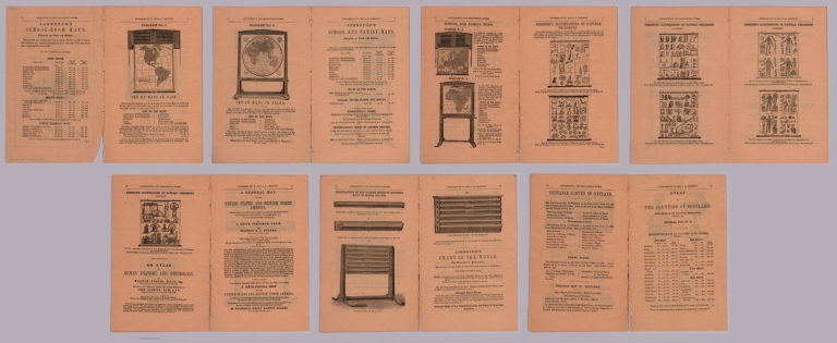
Full Title
(Covers to) List of geographical and educational works, comprising atlases, maps, globes, illustrative diagrams, etc. Published by W. and A. K. Johnston, Geographers and Engravers to the Queen, 4, St Andrew Square, Edinburgh.
List No
14279.001
Note
Covers to W. & A. K. Johnston's List of geographical and educational works, published in Edinburgh, 1858. Bound in beige paper. Front cover features an image of Atlas with the globe on his shoulders. Includes an extended statement of responsibility: Agents in London: E. Stanford, Charing Cross; Groombridge adn Son, Paternoster Row. Glasgow: James Lumsden and Son. Aberdeen: L. and J. Smith. Back cover has an advertisement for "Johnston's modern globes : with the most recent discoveries". Unfolded to 22 x 27. (First page number inferred.)
Author
W. & A.K. Johnston Limited
Full Title
(Composite Text to) List of geographical and educational works, comprising atlases, maps, globes, illustrative diagrams, etc. Published by W. and A. K. Johnston, Geographers and Engravers to the Queen, 4, St Andrew Square, Edinburgh.
List No
14279.002
Note
Composite of fourteen text pages to W. & A. K. Johnston's List of geographical and educational works, catalog published in Edinburgh, 1858. Contains advertisements with lists of available works, including illustrations of examples, such as "Set of maps in case" on page 3. (Date taken from front cover.)
Author
Bagel, A.
Full Title
Post- und Reise-Karte von Deutschland und einem Theile der angrenzenden Länder : nach den besten Hülfsmitteln neu bearbeitet
List No
15559.000
Author
Sonnenstern, Maximilian von
Full Title
(Covers to) Mapa General De La Republica De Salvador Levantado Por Maximilian v. Sonnenstern Por Orden De Su Excelencia Sr. Don Rafael Campo. 1858. Entered ... 1858 by M.v. Sonnenstern ... New York. G. Kraetzer Lith. East New York Long Island. N.Y. (inset) Plano De Nueva San Salvador. (with 4 profiles).
List No
3901.001
Author
Sonnenstern, Maximilian von
Full Title
Mapa General De La Republica De Salvador Levantado Por Maximilian v. Sonnenstern Por Orden De Su Excelencia Sr. Don Rafael Campo. 1858. Entered ... 1858 by M.v. Sonnenstern ... New York. G. Kraetzer Lith. East New York Long Island. N.Y. (inset) Plano De Nueva San Salvador. (with 4 profiles).
List No
3901.002
Author
Kageyama, Muneyasu
Full Title
Ōedo bancho ezu
List No
15059.032
Author
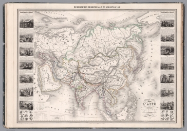
Vuillemin, Alexandre
Full Title
Geographie commercial et industriel : Nouvelle carte illustree de l'Asie : indiquant les grandes division physiques, la distribution geographique des veget́aux et des mineŕaux, les port de commerce, oilles industrielles en places fortes des differentes et́ats. Dressee par A. Vuillemin. Gravee par Langevin. Paris, Chez Fatout, Editeur. 1858. Grave sur acier, la topographie par Gerin, le trait au burin par F. Lefevre, Les illustrations dessinees par A. Testard et gravees par Guesnu. Imprime par Mangeon. Paris. (to accompany) Atlas de geographie commercial et industriel.
List No
13375.004
Note
Engraved outline hand color map of Asia. Includes 14 vignette views of different countries in Asia and 2 sections of fruits and plants in panels at sides. Includes tables, legend and notes.
Author
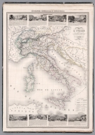
Vuillemin, Alexandre
Full Title
Geographie commercial et industriel : Nouvelle carte illustree de de l'Italie : presentant la division territoriale de ses différents états, les g.des divisions physiques et la distribution géographique des plantes cultivées, les villes industrielles, les principales mines exploitées, les chemins de fer, les routes et les canaux. Dressee par A. Vuillemin. Gravee par Langevin. Paris, Chez Fatout, Editeur. 1858. sur acier, les montagnes par Gerin, le trait au burin par F. Lefevre ; les illustrations dessinees par A. Testard et gravees par Guesnu. Imprime par Mangeon. Paris. (to accompany) Atlas de geographie commercial et industriel.
List No
13375.010
Note
Engraved outline hand color map of Italy. Shows administrative divisions, cities and towns. Includes vignette views of different provinces. Includes legend, tables and notes.
Author
Tsylov, Nikolai Ivanovich,1801-1879
Full Title
(Covers to) Atlas goroda Tsarskogo Sela. S planami: goroda i imperatorskikh sadov i parkov. S podrobnym pokazaniem ulits, pereulkov, kazennykh i obyvatelʹskikh domov i vodoprovodov. Sostavil polkovnik i Tsylov. 1857 goda.
List No
13401.001
Author
Tsylov, Nikolai Ivanovich,1801-1879
Full Title
(Title Page to) Atlas goroda Tsarskogo Sela. S planami: goroda i imperatorskikh sadov i parkov. S podrobnym pokazaniem ulits, pereulkov, kazennykh i obyvatelʹskikh domov i vodoprovodov. Sostavil polkovnik i Tsylov. 1857 goda.
List No
13401.002
Author
Tsylov, Nikolai Ivanovich,1801-1879
Full Title
(Text Page to) Atlas goroda Tsarskogo Sela. S planami: goroda i imperatorskikh sadov i parkov. S podrobnym pokazaniem ulits, pereulkov, kazennykh i obyvatelʹskikh domov i vodoprovodov. Sostavil polkovnik i Tsylov. 1857 goda.
List No
13401.003
Note
Dedication note.
Author
Tsylov, Nikolai Ivanovich,1801-1879
Full Title
(Text Page to) Atlas goroda Tsarskogo Sela. S planami: goroda i imperatorskikh sadov i parkov. S podrobnym pokazaniem ulits, pereulkov, kazennykh i obyvatelʹskikh domov i vodoprovodov. Sostavil polkovnik i Tsylov. 1857 goda.
List No
13401.004
Note
Dedication note by Nikolai Tsylov.
Author
Tsylov, Nikolai Ivanovich,1801-1879
Full Title
(Text Page to) Atlas goroda Tsarskogo Sela. S planami: goroda i imperatorskikh sadov i parkov. S podrobnym pokazaniem ulits, pereulkov, kazennykh i obyvatelʹskikh domov i vodoprovodov. Sostavil polkovnik i Tsylov. 1857 goda.
List No
13401.005
Note
Coat of arms of the royal village.
Author
Tsylov, Nikolai Ivanovich,1801-1879
Full Title
(Legend to) Atlas goroda Tsarskogo Sela. S planami: goroda i imperatorskikh sadov i parkov. S podrobnym pokazaniem ulits, pereulkov, kazennykh i obyvatelʹskikh domov i vodoprovodov. Sostavil polkovnik i Tsylov. 1857 goda.
List No
13401.006
Note
explanation of map symbols.
Author
Tsylov, Nikolai Ivanovich,1801-1879
Full Title
(Portrait) Atlas goroda Tsarskogo Sela. S planami: goroda i imperatorskikh sadov i parkov. S podrobnym pokazaniem ulits, pereulkov, kazennykh i obyvatelʹskikh domov i vodoprovodov. Sostavil polkovnik i Tsylov. 1857 goda.
List No
13401.007
Note
Portrait of Tsar, fot. Dachtendeya.
Author
Tsylov, Nikolai Ivanovich,1801-1879
Full Title
Chasti kvartala. (to accompany) Atlas goroda Tsarskogo Sela. Sostavil polkovnik i Tsylov. 1857 goda.
List No
13401.008
Note
Color plan of parts of the quarter.
|