|
Author
Arrowsmith, John, 1790-1873
Full Title
India, by J. Arrowsmith. London. Pubd. 15 Feby. 1857, by J. Arrowsmith, 10 Soho Square.
List No
14506.057
Note
Map representing current-day India, Nepal, Bhutan, Bangladesh, Sri Lanka, and Republic of Maldives. Shows political boundaries, cities, roads, topography, bodies of water, drainage, coastlines, and islands. Relief shown with hachures. Includes a legend, latitudinal and longitudinal lines, as well as bar scales given in cosses, geographical and English miles. Hand-colored engraving. Map is 62 x 52 cm, on double sheet 67 x 56 cm.
Author
[Arrowsmith, John, 1790-1873, Murchison, Roderick Impey, Sir, 1792-1871, Yule, Henry, Sir, 1820-1889]
Full Title
(Composite map of) This new map of Burma and the regions adjacent; is inscribed to Sir Roderick Murchison, P.R.G.S. &c. &c. &c. By H. Yule, Captn. Bengal Engrs. London, 1857. John Arrowsmith.
List No
14506.063
Note
Composite map representing current-day Myanmar and part of Thailand. Shows political boundaries, cities, roads, topography, bodies of water, drainage, coastlines, and islands. Relief shown with hachures. Includes a glossary and informational text, as well as latitudinal and longitudinal lines, as well as a bar scale given in English miles. Hand-colored engraving.
Author
Logerot, A. (Auguste)
Full Title
(Covers to) Atlas elémentaire.
List No
14489.001
Note
Covers to Atlas elémentaire. Folio. Bound in board, covered in marbled papers. With leather spine.
Author
Logerot, A. (Auguste)
Full Title
(Title Page to) Atlas elémentaire fait pour Monsieur A. Logerot, elève au Pensionnat Professionnel de M. Ph. Pompeé pour servir au cours professé por M. Chatteau. 1856-1857, Ivry sur Seine, 1er et 2th anviée.
List No
14489.002
Note
Title page to Atlas elémentaire ... Handwritten in ink with pencil underlines. (Page number inferred.)
Author
Logerot, A. (Auguste)
Full Title
[Map of Europe.] Ce 8 8bre 1856 ; A. Logerot.
List No
14489.003
Note
Manuscript map representing Europe. Shows select regions, mountain ranges, drainage, coastlines, and islands. Relief shown with hachure lines and shading. Indexed to indicate the names of mountain ranges. Ink, pencil, and watercolor on paper. Indexed to indicate locations such as the Tyrolean Alps and Saint-Gotthard Massif. Map is 24 x 30 cm, on sheet 24 x 32 cm.
Author
Logerot, A. (Auguste)
Full Title
[Map of Europe.] Ce 15 8bre 1856 ; A. Logerot.
List No
14489.004
Note
Manuscript map representing Europe. Shows select regions, cities, mountain ranges, drainage, coastlines, and islands. Relief shown with shading. Features watershed areas, which are differentiated by color. Indexed to indicate the names of mountains and lakes. Ink, pencil, and watercolor on paper. Map is 24 x 30 cm, on sheet 24 x 32 cm.
Author
Logerot, A. (Auguste)
Full Title
Mer Blanche. Ce 23 8bre 1856 ; A. Logerot.
List No
14489.005
Note
Manuscript map representing the White Sea. Shows select regions, cities, mountain ranges, drainage, coastlines, and islands. Relief shown with shading. Ink, pencil, and watercolor on paper. Map is 24 x 30 cm, on sheet 24 x 32 cm.
Author
Logerot, A. (Auguste)
Full Title
Rhin Suisse. Ce 18 Fevrier 1857 ; A. Logerot.
List No
14489.015
Note
Manuscript map representing the watershed of the Rhine River in Switzerland. Shows select regions, cities, mountain ranges, drainage, and bodies of water. Relief shown with shading. Ink, pencil, and watercolor on paper. Map is 22 x 28 cm, on sheet 24 x 31 cm.
Author
Logerot, A. (Auguste)
Full Title
[France.] A. Logerot.
List No
14489.021
Note
Manuscript map representing France. Shows select regions, mountain ranges, drainage, coastlines, and islands. Relief shown with shading. Ink, pencil, and watercolor on paper. Map is 23 x 29 cm, on sheet 24 x 31 cm.
Author
Logerot, A. (Auguste)
Full Title
[Armorican Massif, France.] Ce 98 Mai 1857 ; A. Logerot.
List No
14489.025
Note
Manuscript map representing the Armorican Massif in France. Shows select regions, cities, mountain ranges, drainage, coastlines, and islands. Relief shown with shading. Ink, pencil, and watercolor on paper. Map is 21 x 29 cm, on sheet 24 x 31 cm.
Author
Logerot, A. (Auguste)
Full Title
[Loire River.] A. Logerot.
List No
14489.026
Note
Manuscript map representing the Loire River basin in France. Shows select regions, cities, mountain ranges, drainage, coastlines, and islands. Relief shown with shading. Ink, pencil, and watercolor on paper. Map is 23 x 30 cm, on sheet 23 x 30 cm.
Author
Logerot, A. (Auguste)
Full Title
[Loire River.] A. Logerot.
List No
14489.027
Note
Manuscript map representing the Loire River basin in France. Shows select regions, cities, mountain ranges, drainage, coastlines, and islands. Relief shown with shading. Ink, pencil, and watercolor on paper. Map is 23 x 29 cm, on sheet 23 x 30 cm.
Author
Logerot, A. (Auguste)
Full Title
Asie mineure. A. Logerot.
List No
14489.038
Note
Manuscript map representing Asia Minor. Shows select regions, cities, mountain ranges, drainage, coastlines, and islands. Relief shown with shading. Ink, pencil, and watercolor on paper. Map is 21 x 27 cm, on sheet 24 x 31 cm.
Author
Logerot, A. (Auguste)
Full Title
Afrique. A. Logerot ; Ce 8 Janvier 1856.
List No
14489.041
Note
Manuscript map representing Africa. Shows select regions, cities, mountain ranges, deserts, drainage, coastlines, and islands. Relief shown with shading. Ink, pencil, and watercolor on paper. Map is 22 x 28 cm, on sheet 24 x 31 cm. (Page number written as “43” for page 44 in volume.)
Author
Logerot, A. (Auguste)
Full Title
Amerique du Noro. A. Logerot.
List No
14489.042
Note
Manuscript map representing North America. Shows select regions, mountain ranges, coastlines, and islands. Ink, pencil, and watercolor on paper. Map is 30 x 23 cm, on sheet 30 x 23 cm.
Author
Logerot, A. (Auguste)
Full Title
Amérique Septentrionale. A. Logerot.
List No
14489.043
Note
Manuscript map representing North America. Shows select regions, mountain ranges, drainage, bodies of water, coastlines, and islands. Relief shown with shading. Ink, pencil, and watercolor on paper. Map is 27 x 23 cm, on sheet 31 x 23 cm.
Author
Logerot, A. (Auguste)
Full Title
[North and South America.] A. Logerot.
List No
14489.044
Note
Manuscript map representing North and South America. Shows select regions, mountain ranges, drainage, bodies of water, coastlines, and islands. Relief shown with shading. Ink, pencil, and watercolor on paper. Map is 31 x 23 cm, on sheet 31 x 23 cm.
Author
Logerot, A. (Auguste)
Full Title
[South America.] A. Logerot.
List No
14489.045
Note
Manuscript map representing South America. Shows select regions, mountain ranges, drainage, coastlines, and islands. Relief shown with shading. Ink, pencil, and watercolor on paper. Map is 22 x 28 cm, on sheet 30 x 23 cm.
Author
Logerot, A. (Auguste)
Full Title
Océanie. A. Logerot.
List No
14489.046
Note
Manuscript map representing Oceania. Shows select regions, cities, mountain ranges, drainage, coastlines, and islands. Relief shown with shading. Ink, pencil, and watercolor on paper. Map is 22 x 28 cm, on sheet 24 x 30 cm.
Author
[Bouchette, Joseph Jun., Cauchon, Joseph, Canada Crown Lands Department]
Full Title
(Covers to) Appendix to report of the Commissioner of Crown Lands, part II : Maps of Canada
List No
15897.001
Author
[Bouchette, Joseph Jun., Cauchon, Joseph, Canada Crown Lands Department]
Full Title
(Title page to) Appendix to report of the Commissioner of Crown Lands, part II : Maps of Canada
List No
15897.002
Author
[Bouchette, Joseph Jun., Cauchon, Joseph, Canada Crown Lands Department]
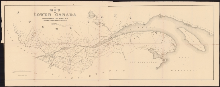
Full Title
No. 1 Map of Lower Canada : shewing the proposed land agencies and the townships distinct from the seigniories
List No
15897.003
Author
[Bouchette, Joseph Jun., Cauchon, Joseph, Canada Crown Lands Department]
Full Title
No. 2 Map of Upper Canada Shewing the Proposed Land Agency Divisions.
List No
15897.004
Author
[Bouchette, Joseph Jun., Cauchon, Joseph, Canada Crown Lands Department]
Full Title
No. 3 Map of the counties of Gaspe and Bonaventure : exhibiting the lands adjudicated, unsurveyed, Clergy Reserves &c. &c. &c.
List No
15897.005
Author
[Bouchette, Joseph Jun., Cauchon, Joseph, Canada Crown Lands Department]
Full Title
No. 4 Plan of the River Saguenay
List No
15897.006
Author
[Bouchette, Joseph Jun., Cauchon, Joseph, Canada Crown Lands Department]
Full Title
No. 5 Plan of the St. Maurice Territory
List No
15897.007
Author
[Bouchette, Joseph Jun., Cauchon, Joseph, Canada Crown Lands Department]
Full Title
No. 6 Map of the Ottawa and Huron Territory
List No
15897.008
Author
[Bouchette, Joseph Jun., Cauchon, Joseph, Canada Crown Lands Department]
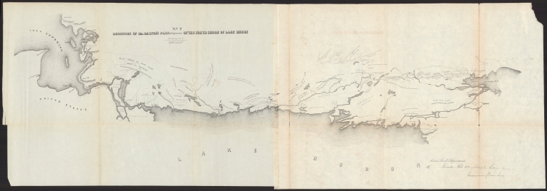
Full Title
No. 7.Reduction of Mr. Salter's plan of exploration of the north shore of Lake Huron
List No
15897.009
Note
Shows Indian reserves, with notes about surface features, soils and forests
Author
[Devine, Thomas, Cauchon, Joseph, Canada Crown Lands Department]
Full Title
(No. 8) Map of the North West Part of Canada Indian Territories & Hudson's Bay.
List No
15897.010
Note
See our 15873.000 for a geologically colored copy.
Author
Devine, Thomas
Full Title
Map of the North West Part of Canada Indian Territories & Hudson's Bay Compiled & Drawn by Thos. Devin Provincial Land Surveyor & Draftsman . . . March, 1857
List No
15873.000
Author
Henn, Williams & Co.
Full Title
(Covers to) A sectional map of Iowa : compiled from the official surveys of the United States and the public records of the state & counties and from personal reconnoissance
List No
15414.001
Author
Henn, Williams & Co.
Full Title
A sectional map of Iowa : compiled from the official surveys of the United States and the public records of the state & counties and from personal reconnoissance
List No
15414.002
Author
Perrot, A.M.
Full Title
Carte Pittoresque Et Maritime De La France Indiquant ... Par A.M. Perrot, Revue et augmentee par A. Vuillemin, Paris 1857. Fatout Editeur Boulevard Poissonniere, 17. Chez Fatout ...
List No
0707.001
Author
Tomatsu, Masanori, active 19th century
Full Title
Aoyama shibuya ezu
List No
15059.006
Author
Tomatsu, Masanori, active 19th century
Full Title
Meguro Shirogane atari no zu.
List No
15059.008
Author
Tomatsu, Masanori, active 19th century
Full Title
Komagome ezu
List No
15059.014
Author
Tomatsu, Masanori, active 19th century
Full Title
Otowa ezu
List No
15059.016
Author
Kageyama, Muneyasu
Full Title
Akasaka ezu
List No
15059.028
Author
Tomatsu, Masanori, active 19th century
Full Title
Yotsuya ezu
List No
15059.030
Author
Kageyama, Muneyasu
Full Title
Ogawachō ezu
List No
15059.034
Author
Kageyama, Muneyasu
Full Title
Nihonbashi minami ezu
List No
15059.038
Author
Kageyama, Muneyasu
Full Title
Daimyōkōji ezu
List No
15059.042
Author
Kageyama, Muneyasu
Full Title
Shiba takanawa ezu
List No
15059.048
Author
Tomatsu, Masanori, active 19th century
Full Title
Koishikawa ezu
List No
15059.052
Author
Tomatsu, Masanori, active 19th century
Full Title
Hongō Yushima ezu
List No
15059.054
Author
Tomatsu, Masanori, active 19th century
Full Title
Shitaya ezu
List No
15059.056
Author
Iyama, Yoshitomo
Full Title
Okuramae atari no zu
List No
15059.058
Author
Tomatsu, Masanori, active 19th century
Full Title
Kobinata ezu
List No
15059.060
Author
Tomatsu, Masanori, active 19th century
Full Title
Ichigaya ezu
List No
15059.062
Author
Tomatsu, Masanori, active 19th century
Full Title
Hatchobori detailed view
List No
15059.064
Author
Vuillemin, Alexandre
Full Title
(Covers/Title to) Atlas de geographie commercial et industriel.
List No
13375.001
Note
Cover title.
Author
Vuillemin, Alexandre
Full Title
Planisphere Elementaire et Illustre : Indiquant la description geographique des parties connues de la terre, les decouvertes navigateurs : Les colonies Europeennes, ,les principaux parcours des paquebots, l'epoque des departs, la duree du trajel. & ca. Dresse par A. Vuillemin, Geìographe. Paris, Chez, Fatout, editeur. 1857. Grave par Langevin. Imp. par Alfred Chardon jeune & Fils, 3, rue Racine, Paris. (to accompany) Atlas de geographie commercial et industriel.
List No
13375.002
Note
Engraved color map of the world. At the bottom are views of national costumes of the world and comparative heights of the mountains and length rivers of the world. Showing depiction of the polar regions. Includes small decorative vignettes, text, inset and tables. Relief shown by hachures.
Author
Vuillemin, Alexandre
Full Title
Geographie commercial et industriel : Nouvelle carte illustree de l'Europe : presentant les grandes divisions physiques, la distribution géographique des vegetaux et des mineraux, les villes industrielles, les ports de commerce, les places fortes, les chemins de fer & a. Dressee par A. Vuillemin. Gravee par Langevin. Paris, Chez Fatout, Editeur. 1857. Grave sur acier, la topographie par Gerin, le trait au burin par F. Lefevre, Les illustrations dessinees par A. Testard et gravees par Guesnu. Imprime par Mangeon. Paris. (to accompany) Atlas de geographie commercial et industriel.
List No
13375.003
Note
Engraved outline hand color map of Europe. Includes vignettes views of the industrial cities and the commercial ports.
Author
Vuillemin, Alexandre
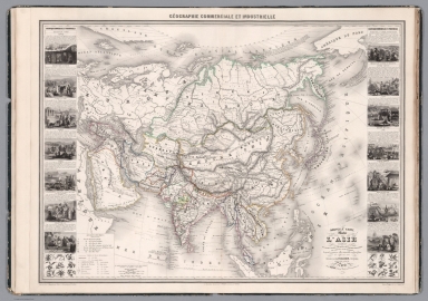
Full Title
Geographie commercial et industriel : Nouvelle carte illustree de l'Asie : indiquant les grandes division physiques, la distribution geographique des veget́aux et des mineŕaux, les port de commerce, oilles industrielles en places fortes des differentes et́ats. Dressee par A. Vuillemin. Gravee par Langevin. Paris, Chez Fatout, Editeur. 1858. Grave sur acier, la topographie par Gerin, le trait au burin par F. Lefevre, Les illustrations dessinees par A. Testard et gravees par Guesnu. Imprime par Mangeon. Paris. (to accompany) Atlas de geographie commercial et industriel.
List No
13375.004
Note
Engraved outline hand color map of Asia. Includes 14 vignette views of different countries in Asia and 2 sections of fruits and plants in panels at sides. Includes tables, legend and notes.
Author
Vuillemin, Alexandre
Full Title
Geographie commercial et industriel : Nouvelle carte illustree de l'Afrique : presentant les grandes divisions physiques, la distribution geographique des vegetaux et des minéraux, les ports de commerce, villes industrielles et fortifiees des differents etats. Dressee par A. Vuillemin. Gravee par Langevin. Paris, Chez Fatout, Editeur. 1857. Grave sur acier, la topographie par Gerin, le trait au burin par F. Lefevre, Les illustrations dessinees par A. Testard et gravees par Guesnu. Imp. par Mangeon. Paris. (to accompany) Atlas de geographie commercial et industriel.
List No
13375.005
Note
Engraved outline hand color map of Africa. Includes 18 vignette views of different countries in Africa and 2 sections of fruits and plants in panels at sides. Includes tables, legend and notes.
Author
Vuillemin, Alexandre
Full Title
Geographie commercial et industriel : Nouvelle carte illustree de l'Amerique du Nord : indiquant les grandes divisions physiques, la distribution geographique des vegetaux et des mineraux, les ports de commerce, villes industrielles et fortifiees des differents etats. Dressee par A. Vuillemin. Gravee par Langevin. Paris, Chez Fatout, Editeur. 1857. Grave sur acier, la topographie par Gerin, le trait au burin par F. Lefevre, Les illustrations dessinees par A. Testard et gravees par Guesnu. Imp. par Mangeon. Paris. (to accompany) Atlas de geographie commercial et industriel.
List No
13375.006
Note
Engraved outline hand color map of North America. Includes 14 vignette views of different countries in North America, European colonies, and 2 sections of fruits and plants in panels at sides. Includes tables, legend and notes.
Author
Vuillemin, Alexandre
Full Title
Geographie commercial et industriel : Nouvelle carte illustree de l'Amerique du Sud : indiquant les grandes divisions physiques, la distribution geographique des vegetaux et des mineraux, les ports de commerce, villes industrielles et fortifiees des differents etats. Dressee par A. Vuillemin. Gravee par Langevin. Paris, Chez Fatout, Editeur. 1857. Grave sur acier, la topographie par Gerin, le trait au burin par F. Lefevre, Les illustrations dessinees par A. Testard et gravees par Guesnu. Imp. par Mangeon. Paris. (to accompany) Atlas de geographie commercial et industriel.
List No
13375.007
Note
Engraved outline hand color map of South America, with inset: Carte donnant les parcours des bateaux a vapeur sur l'Atlantique el l'Ocean Pacifique. Includes 12 vignette views of different countries in South America, European colonies, and 2 sections of fruits and plants in panels at sides. Includes tables, legend and notes.
Author
Vuillemin, Alexandre
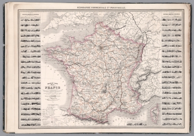
Full Title
Geographie commercial et industriel : Nouvelle carte illustree de la France : presentant les grandes divisions physiques, la distribution geographique des vegetaux et des mineraux, les ports de commerce en les possessions coloniales des Europeens. Dressee par A. Vuillemin. Gravee par Langevin. Paris, Chez Fatout, Editeur. 1857. Grave sur acier, la topographie par Gerin, le trait au burin par Langevin, Les illustrations dessinees par A. Testard et gravees par Guesnu. Imprime par Mangeon. Paris. (to accompany) Atlas de geographie commercial et industriel.
List No
13375.008
Note
Engraved outline hand color map of France, with inset: Corse. Shows administrative divisions, cities and towns. Includes vignette views of different provinces and departments. Includes legend, tables and notes.
Author
Vuillemin, Alexandre
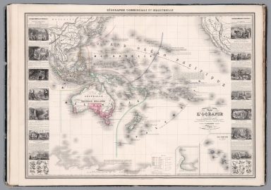
Full Title
Geographie commercial et industriel : Nouvelle carte illustree de l'Oceanie : presentant les Divisions Physiques, la Distribution Géographique des Plantes Cultiveés, la Division Territoriale Comparative des Anciennes Provinces et des Départements Actuels, les usines importantes, les principales mines exploitées, les canaux, les chemins de fer & a.. Dressee par A. Vuillemin. Gravee par Langevin. Paris, Chez Fatout, Editeur. 1857. Grave sur acier, la topographie par Gerin, le trait au burin par F. Le,fevre. Les illustrations dessinees par A. Testard et gravees par Guesnu. Imp. par Mangeon. Paris. (to accompany) Atlas de geographie commercial et industriel.
List No
13375.009
Note
Engraved outline hand color map of Oceania, with 2 insets: Terre Victoria; Iles Nouka-Hiva ou Iles Marquises (a la France). Includes 12 vignette views of different countries in Oceania, and 2 sections of fruits and plants in panels at sides. Includes color coded key to European colonies, legend and notes.
Author
Vuillemin, Alexandre
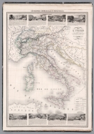
Full Title
Geographie commercial et industriel : Nouvelle carte illustree de de l'Italie : presentant la division territoriale de ses différents états, les g.des divisions physiques et la distribution géographique des plantes cultivées, les villes industrielles, les principales mines exploitées, les chemins de fer, les routes et les canaux. Dressee par A. Vuillemin. Gravee par Langevin. Paris, Chez Fatout, Editeur. 1858. sur acier, les montagnes par Gerin, le trait au burin par F. Lefevre ; les illustrations dessinees par A. Testard et gravees par Guesnu. Imprime par Mangeon. Paris. (to accompany) Atlas de geographie commercial et industriel.
List No
13375.010
Note
Engraved outline hand color map of Italy. Shows administrative divisions, cities and towns. Includes vignette views of different provinces. Includes legend, tables and notes.
Author
Tsylov, Nikolai Ivanovich,1801-1879
Full Title
(Covers to) Atlas goroda Tsarskogo Sela. S planami: goroda i imperatorskikh sadov i parkov. S podrobnym pokazaniem ulits, pereulkov, kazennykh i obyvatelʹskikh domov i vodoprovodov. Sostavil polkovnik i Tsylov. 1857 goda.
List No
13401.001
Author
Tsylov, Nikolai Ivanovich,1801-1879
Full Title
(Title Page to) Atlas goroda Tsarskogo Sela. S planami: goroda i imperatorskikh sadov i parkov. S podrobnym pokazaniem ulits, pereulkov, kazennykh i obyvatelʹskikh domov i vodoprovodov. Sostavil polkovnik i Tsylov. 1857 goda.
List No
13401.002
Author
Tsylov, Nikolai Ivanovich,1801-1879
Full Title
(Text Page to) Atlas goroda Tsarskogo Sela. S planami: goroda i imperatorskikh sadov i parkov. S podrobnym pokazaniem ulits, pereulkov, kazennykh i obyvatelʹskikh domov i vodoprovodov. Sostavil polkovnik i Tsylov. 1857 goda.
List No
13401.003
Note
Dedication note.
Author
Tsylov, Nikolai Ivanovich,1801-1879
Full Title
(Text Page to) Atlas goroda Tsarskogo Sela. S planami: goroda i imperatorskikh sadov i parkov. S podrobnym pokazaniem ulits, pereulkov, kazennykh i obyvatelʹskikh domov i vodoprovodov. Sostavil polkovnik i Tsylov. 1857 goda.
List No
13401.004
Note
Dedication note by Nikolai Tsylov.
Author
Tsylov, Nikolai Ivanovich,1801-1879
Full Title
(Text Page to) Atlas goroda Tsarskogo Sela. S planami: goroda i imperatorskikh sadov i parkov. S podrobnym pokazaniem ulits, pereulkov, kazennykh i obyvatelʹskikh domov i vodoprovodov. Sostavil polkovnik i Tsylov. 1857 goda.
List No
13401.005
Note
Coat of arms of the royal village.
Author
Tsylov, Nikolai Ivanovich,1801-1879
Full Title
(Legend to) Atlas goroda Tsarskogo Sela. S planami: goroda i imperatorskikh sadov i parkov. S podrobnym pokazaniem ulits, pereulkov, kazennykh i obyvatelʹskikh domov i vodoprovodov. Sostavil polkovnik i Tsylov. 1857 goda.
List No
13401.006
Note
explanation of map symbols.
Author
Tsylov, Nikolai Ivanovich,1801-1879
Full Title
(Portrait) Atlas goroda Tsarskogo Sela. S planami: goroda i imperatorskikh sadov i parkov. S podrobnym pokazaniem ulits, pereulkov, kazennykh i obyvatelʹskikh domov i vodoprovodov. Sostavil polkovnik i Tsylov. 1857 goda.
List No
13401.007
Note
Portrait of Tsar, fot. Dachtendeya.
Author
Tsylov, Nikolai Ivanovich,1801-1879
Full Title
Chasti kvartala. (to accompany) Atlas goroda Tsarskogo Sela. Sostavil polkovnik i Tsylov. 1857 goda.
List No
13401.008
Note
Color plan of parts of the quarter.
Author
Tsylov, Nikolai Ivanovich,1801-1879
Full Title
Chasti kvartala. (to accompany) Atlas goroda Tsarskogo Sela. Sostavil polkovnik i Tsylov. 1857 goda.
List No
13401.009
Note
Color plan of parts of the quarters.
Author
Tsylov, Nikolai Ivanovich,1801-1879
Full Title
Chasti kvartala. (to accompany) Atlas goroda Tsarskogo Sela. Sostavil polkovnik i Tsylov. 1857 goda.
List No
13401.010
Note
Color plan of parts of the quarters.
Author
Tsylov, Nikolai Ivanovich,1801-1879
Full Title
Chasti kvartala. (to accompany) Atlas goroda Tsarskogo Sela. Sostavil polkovnik i Tsylov. 1857 goda.
List No
13401.011
Note
Color plan of parts of the quarters.
Author
Tsylov, Nikolai Ivanovich,1801-1879
Full Title
Chasti kvartala. (to accompany) Atlas goroda Tsarskogo Sela. Sostavil polkovnik i Tsylov. 1857 goda.
List No
13401.012
Note
Color plan of parts of the quarters.
Author
Tsylov, Nikolai Ivanovich,1801-1879
Full Title
Chasti kvartala. (to accompany) Atlas goroda Tsarskogo Sela. Sostavil polkovnik i Tsylov. 1857 goda.
List No
13401.013
Note
Color plan of parts of the quarters.
Author
Tsylov, Nikolai Ivanovich,1801-1879
Full Title
Chasti kvartala. (to accompany) Atlas goroda Tsarskogo Sela. Sostavil polkovnik i Tsylov. 1857 goda.
List No
13401.014
Note
Color plan of parts of the quarters.
Author
Tsylov, Nikolai Ivanovich,1801-1879
Full Title
Chasti kvartala. (to accompany) Atlas goroda Tsarskogo Sela. Sostavil polkovnik i Tsylov. 1857 goda.
List No
13401.015
Note
Color plan of parts of the quarters.
Author
Decaen Editor
Full Title
(Title Page to) México y sus alrededores. Coleccion de vistas trajes y monumentos por C. Castro, J. Campillo, L. Auda y G. Rodriguez. Publicacion de Decaen Editor. Ejecutado en el Establecimiento Litog. de Decaen. Portal del Coliseo Viejo, México 1855 y 1857. C. Castro del y litog.
List No
14248.022
Note
Title page to México y sus alrededores. Coleccion de vistas trajes y monumentos. Includes a sepia-colored lithographed illustration of a Mexican couple within a scene of abundant native vegetation, including cacti.
Author
Decaen Editor
Full Title
Antiguedades Méxicanas que existen en el Museo nacional de México, 1857 = Mexican antiquities which exist in the National Museum of Mexico, 1857 = Antiquités Mexicaines qui existent au Musée national de Mexico, 1857. C. Castro del y lito. ; Imp. Lito. de Decaen, Mexico Portal del Coliseo Viejo ; Propiedad del Editor.
List No
14248.061
Note
Sepia-colored lithographed view of Mexican antiquities from the National Museum of Mexico in Mexico City (1857). Running title for atlas appears in upper margin. 24 x 34 cm, on sheet 31 x 44 cm.
Author
Robiquet, Aime
Full Title
Carte De La Cote Des Etats-Unis Comprise entre la Nouvelle-Ecosse et la Floride . . . par Robiquet Hydrographe . . . 1857
List No
10713.000
Note
Later issues in 1861 and 1871. 1857 would appear to be the first edition.
Author
Baur, Carl Friedrich
Full Title
(Title Page to) Atlas fur Handel u. Industrie, fur Kaufleute, Fabrikanten u. Gewerbetreibende, Handlungs-u. Gewerbe-Schulen, polytechnische Lehr-Anstalten etc., entworfen, gezeichnet und mit erlauternden Notizen versehen von C.F. Baur. Mannheim 1857. Verlagsbuchhandlung von Friedrich Bassermann. Litho. v. B. Walter Stuttgart.
List No
13199.002
Author
Baur, Carl Friedrich
Full Title
Erdkarte. Entworfen u. gezeichnet v. C. F. Baur. Bassermann Verlagshandlung in Mannheim. (to accompany) Atlas fur Handel u. Industrie, fur Kaufleute, Fabrikanten u. Gewerbetreibende ... von C.F. Baur. 1857.
List No
13199.005
Note
Latest color map of the earth, showing political divisions, trade and European colonies. Includes explanation at the foot of map and color reference to European countries and colonies.
Author
Baur, Carl Friedrich
Full Title
Grossbritannien. Entworfen u. gezeichnet v. C. F. Baur. Bassermann' sche Verlagshandlung in Mannheim. (to accompany) Atlas fur Handel u. Industrie, fur Kaufleute, Fabrikanten u. Gewerbetreibende ... von C.F. Baur. 1857.
List No
13199.007
Note
Color map, with inset map of London. Shows major cities, roads, railroads, and shipping routes. Includes reference to agricultural, mineral and industrial products, and table of import and export.
Author
Baur, Carl Friedrich
Full Title
Frankreich. Entworfen u. gezeichnet v. C. F. Baur. Bassermann Verlagshandlung in Mannheim. (to accompany) Atlas fur Handel u. Industrie, fur Kaufleute, Fabrikanten u. Gewerbetreibende ... von C.F. Baur. 1857.
List No
13199.009
Note
Color map, with inset map of Umgebung von Paris. Shows major cities, roads, railroads, and shipping routes. Includes reference to agricultural, mineral and industrial products, and table of import and export.
Author
Baur, Carl Friedrich
Full Title
Vereinigte Staaten und Mexiko. Entworfen u. gezeichnet v. C. F. Baur. Bassermannsche Verlagshandlung in Mannheim. B. Walther lith. (to accompany) Atlas fur Handel u. Industrie, fur Kaufleute, Fabrikanten u. Gewerbetreibende ... von C.F. Baur. 1857.
List No
13199.049
Note
Color map. Includes color coded reference. Shows political and administrative boundaries, major cities, roads and shipping routes. Includes list of 24 States in Unite States and 20 Mexican States.
Author
Vandermaelen, Philippe, 1795-1869
Full Title
(Title Page to) Carte de l'Allemagne, en 20 feuilles a l'echelle de 1 a 600,000 Etablissement geographique de Bruxelles fonde par Ph. Vander Maelen.
List No
13202.002
Note
Engraved title page includes Index map "Tableau d'Assemblage", and legend "Signes conventionnels."
Author
Vandermaelen, Philippe, 1795-1869
Full Title
(Composite Map) Allemagne. Etablissement Geographique de Bruxelles. (to accompany) Carte de l'Allemagne ... par Ph. Vander Maelen.
List No
13202.022
Note
Composite map of sheets 1-20.
Author
Rodriguez, Eugenio
Full Title
(Title Page to) Atlante Della Guida Generale Per La Navigazione Delle Coste Settentrionali Ed Orientali dell'America del Sud dall Rio della Plata al Para accompagnata dalle carte degli atterraggi e dalle piante delle baie, rade, porti, ed entrate de'principali fiumi navigabili ... ; riprodotte sulle migliori e piu recenti di reputati idrografi e navigatori e principalmente su quelle del Barone Roussin ; raccolte durante la Campagna della Fregata l'Urania nell'Oceano Atlantico Australe per Eugenio Rodriguez ..., Napoli 1857.
List No
13048.002
Author
Rodriguez, Eugenio
Full Title
(Composite map to) No. 1-4 Carte generale delle coste del Brasile Del Rio del Plata al Para ... No. 4. Anno 1857. Lit. Richter e C. Napoli. (to accompany) Atlante Della Guida Generale Per La Navigazione Delle Coste Settentrionali Ed Orientali dell'America del Sud ... per Eugenio Rodriguez ..., Napoli 1857.
List No
13048.039
Note
Folded nautical charts of the coasts of Brazil, from River Plate to Para. Relief shown by hachures. Depth shown by isolines and soundings. Includes legend and explanation.
Author
Rodriguez, Eugenio
Full Title
Pianta dell' entrata della Baia di Rio Janeiro : su quella levata dal Sigr. Jehenne. (to accompany) Atlante Della Guida Generale Per La Navigazione Delle Coste Settentrionali Ed Orientali dell'America del Sud ... per Eugenio Rodriguez ..., Napoli 1857. (inset view) Vesuta dell entrada della baia di Rio Janeiro ...
List No
13048.014
Note
Folded nautical chart of the Bay of Rio de Janeiro. Scala di 4 miglia marittime (= 11.9 cm). Relief shown by hachures. Depth shown by isolines and soundings. Includes legend and explanation.
Author
Rodriguez, Eugenio
Full Title
Entrata della baia di Rio Janeiro. (to accompany) Atlante Della Guida Generale Per La Navigazione Delle Coste Settentrionali Ed Orientali dell'America del Sud ... per Eugenio Rodriguez ..., Napoli 1857.
List No
13048.015
Note
View of the entrance to the Bay of Rio Janeiro.
Author
Rodriguez, Eugenio
Full Title
Pianta della Baia di Rio - Janeiro : su quella levata dal Sigr. Barral ... Publicata nel 1843 Deposito Generale delle Carte della Marina Imperiale Francese. (to accompany) Atlante Della Guida Generale Per La Navigazione Delle Coste Settentrionali Ed Orientali dell'America del Sud ... per Eugenio Rodriguez ..., Napoli 1857.
List No
13048.016
Note
Folded nautical chart of the Bay of Rio de Janeiro. Scala di otto miglia marittime (= 23.9 cm). Relief shown by hachures. Depth shown by isolines and soundings. Includes legend and explanation.
Author
Minard, Charles Joseph, 1781-1870
Full Title
Carte figurative et approximative des tonnages de marchandises qui ont circulé en 1855 sur les voies d'eau et fer de l'Empire français. [Flow of merchandise in France on railways and waterways in the year 1855].
List No
10140.002
Note
Folds into covers with label "Tonnages 1855" Robinson, no.12. This map is part of a 9 map subset of the 15 Minard maps that shows the flow of merchandise in France on railways and waterways in the years 1850 to 1861, Pub List No.'s 10138.000 to 10146.000
Author
Minard, Charles Joseph, 1781-1870
Full Title
Carte figurative et approximative des tonnages de marchandises qui ont circulé en 1856 sur les voies d'eau et fer de l'Empire français. [Flow of merchandise in France on railways and waterways in the year 1856].
List No
10141.002
Note
Folds into covers with label "Tonnages 1856" Robinson, no.13. Inscribed by Minard to Charles Didion. Charles Didion (1803-1882) was a French engineer and presumably made Minard's acquaintance at the School for Bridges and Roads, where Didion later became secretary of the general council. This map is part of a 9 map subset of the 15 Minard maps that shows the flow of merchandise in France on railways and waterways in the years 1850 to 1861, Pub List No.'s 10138.000 to 10146.000
Author
Minard, Charles Joseph, 1781-1870
Full Title
Carte figurative et approximativedes tonnages de marchandises qui ont circulé en 1857 sur les voies d'eau et fer de l'Empire français. [Flow of merchandise in France on railways and waterways in the year 1857].
List No
10142.002
Note
Folds into covers with label "Tonnages 1857" Robinson, no.17. Inscribed by Minard to Charles Didion. Charles Didion (1803-1882) was a French engineer and presumably made Minard's acquaintance at the School for Bridges and Roads, where Didion later became secretary of the general council. This map is part of a 9 map subset of the 15 Minard maps that shows the flow of merchandise in France on railways and waterways in the years 1850 to 1861, Pub List No.'s 10138.000 to 10146.000
Author
Boschke, Albert
Full Title
Map of Washington City, District of Columbia. Seat of the Federal Government. Respectfully Dedicated to the Senate and the House of Representatives of the United States of North America. Surveyed and published by A. Boschke, C.E. 1857.
List No
12363.000
Author
[United States Coast Survey, Rodgers, A.F.]
Full Title
U.S. Coast Survey A.D. Bache, Superintendent. City Of San Francisco And Its Vicinity California. From a plane label survey by A.F. Rogers Sub-assistant. Verified W.R. Palmer Capt. Topl. Engrs. Asst. C.S. In charge of Office. Lith. of J. Bien 60 Fulton St. N.Y.
List No
6811.000
Note
Rare first edition of the U.S. Coast Survey map of the City of San Francisco and vicinity. Printed without color. Relief shown by contours and spot heights. Includes note and table of reference to public buildings. 1857 edition marked a significant improvement in the USCS's mapping of San Francisco. Prepared by A.F. Rogers, it captured the tremendous growth of the City, locating wharves, streets, buildings, roads, topographical features and places such as the Union Race Course and Pioneer Race Course, west of the City. While first issued and corrected in 1857, neither of the 1857 editions was never published in the regular annual Coast Survey reports until a revised edition, dated 1859, was issued. This chart was first issued in 1857, with another edition issued later in 1857 that differs from the earlier edition and is apparently the same as 1859 edition see our 1030). The first edition does not include soundings, has a shorter "note" in the top right corner, and does not include the "Blosom rock Buoy" which appears below the table. It also does not include the "hydrography by Lieut. R.M. Cuyler". OCLC locates only 3 copies of this 1857 edition at San Francisco National Maritime Museum, University of Wisconsin, Milwaukee, and the British Library.
Author
Blanchard, Rufus
Full Title
Map Of Chicago. Rufus Blanchard, 52 La Salle Street. 1857.
List No
0079.001
Note
Rare pre fire map of the city. Wax engraved. One of the first maps that Blanchard produced himself, without Morse or others. With a list of Omnibus Lines, Legal Hack or Cab Fare, and Population. Uncolored. Map is folded into stamped brown cloth covers 15.5x10 with "Blanchard's Map Of Chicago. 1857" in gilt.
Author
Garcia Cubas, Antonio, 1832-1912
Full Title
(Covers to) Noticias geograficas y estadisticas de laRepublica Mexicana. Mexico. Imptenta de J.M. Lara, v. de la Palma, No. 4. 1857. (cover title) Cuadro geografico y estadistico de la Republica Mexicana. (Map title) Carta general de la Republica Mexicana. Imp. litog. de H. Iriarte y Ca calle de Sta Clara No. 23. J.M. Munozguren Litografia.
List No
8389.001
Note
27 pages of text, with 1 folded color map, 40x35 of Mexico. Includes: geographical, agricultural, mineral, and population information and explanatory text. Map shows administrative divisions, capitals, cities, villages, mines, etc.
Author
Garcia Cubas, Antonio, 1832-1912
Full Title
Carta general de la Republica Mexicana : formada para el estudio de la configuracion y division interior de su territorio. Imp. litog. de H. Iriarte y Ca calle de Sta Clara No. 23. J.M. Munozguren Litografia. (to accompany) Noticias geograficas y estadisticas de la Republica Mexicana. Mexico. Imptenta de J.M. Lara, v. de la Palma, No. 4. 1857. (cover title) Cuadro geografico y estadistico de la Republica Mexicana. (inset) Plan fisico o perfil del camino de Acapulcoa Veracruz.
List No
8389.005
Note
Folded color map of Mexico, 40x35. Includes: geographical, agricultural, mineral, and population information and explanatory text. Map shows administrative divisions, capitals, cities, villages, mines, etc.
Author
Garcia Cubas, Antonio, 1832-1912
Full Title
(Title Page to) Noticias geograficas y estadisticas de laRepublica Mexicana. Mexico. Imptenta de J.M. Lara, v. de la Palma, No. 4. 1857. (cover title) Cuadro geografico y estadistico de la Republica Mexicana. (Map title) Carta general de la Republica Mexicana. Imp. litog. de H. Iriarte y Ca calle de Sta Clara No. 23. J.M. Munozguren Litografia.
List No
8389.002
Note
27 pages of text, with 1 folded color map, 40x35 of Mexico. Includes: geographical, agricultural, mineral, and population information and explanatory text. Map shows administrative divisions, capitals, cities, villages, mines, etc.
Author
Garcia Cubas, Antonio, 1832-1912
Full Title
(Title Page to) Mi apreciable amigo el Senor D. Jose Salazar Ilarregui, Catedratico del Colegio nacional de Mineral. (to accompany) Noticias geograficas y estadisticas de laRepublica Mexicana. Mexico. Imptenta de J.M. Lara, v. de la Palma, No. 4. 1857. (cover title) Cuadro geografico y estadistico de la Republica Mexicana. (Map title) Carta general de la Republica Mexicana : formada para el estudio de la configuracion y division interior de su territorio. Imp. litog. de H. Iriarte y Ca calle de Sta Clara No. 23. J.M. Munozguren Litografia.
List No
8389.003
Note
Dedication page: Dedicated to Jose Salazar Ilarregui. 27 pages of text, with 1 folded color map, 40x35 of Mexico. Includes: geographical, agricultural, mineral, and population information and explanatory text. Map shows administrative divisions, capitals, cities, villages, mines, etc.
Author
Garcia Cubas, Antonio, 1832-1912
Full Title
(Composite text) Noticias geograficas y estadisticas de laRepublica Mexicana. Mexico. Imptenta de J.M. Lara, v. de la Palma, No. 4. 1857. (cover title) Cuadro geografico y estadistico de la Republica Mexicana. (Map title) Carta general de la Republica Mexicana : formada para el estudio de la configuracion y division interior de su territorio. Imp. litog. de H. Iriarte y Ca calle de Sta Clara No. 23. J.M. Munozguren Litografia.
List No
8389.004
Note
27 pages of text, with 1 folded color map, 40x35 of Mexico. Includes: geographical, agricultural, mineral, and population information and explanatory text. Map shows administrative divisions, capitals, cities, villages, mines, etc.
Author
Maury, Matthew Fontaine, 1806-1873
Full Title
VI. Gulf Stream and drift. (to accompany) The Physical Geography of the Sea. By M.F. Maury. An Entirely New Edition, With Addenda. (inset diagram) Thermal section of the the Gulf Stream
List No
0475.013
Note
Uncolored map with inset. Includes explanation and notes. Shows the channel of the Gulf Stream for summer and winter. The diagram represents thermometrical profile represented by cross section of the Gulf Stream.
Author
Blanchard, Rufus
Full Title
(Covers to) Map Of Chicago. Rufus Blanchard, 52 La Salle Street. 1857.
List No
0079A
Author
Emory, William H.
Full Title
(Title Page to) Report on the United States and Mexican Boundary Survey, Made Under The Direction of the Secretary of the Interior, By William H. Emory, Major First Cavalry And United States Commissioner ... Washington: Cornelius Wendell, Printer. 1857. House of Representatives, 34th Congress, 1st Session. Ex. Doc. No. 135. (Two volumes.)
List No
0263A
Note
View of the military plaza in San Antonio, Texas.
Author
Emory, William H.
Full Title
Map Of The United States And Their Territories Between The Mississippi And The Pacific Ocean And Part Of Mexico Compiled From The Surveys Made Under The Order Of W.H. Emory. ... And from the Maps of the Pacific Rail Road, General Land Office, and the Coast Survey. Projected and drawn under the supervision of Lt. N. Michler, Topl. Engrs. By Thomas Jekyll, C.E. 1857-8. Engraved by Selmar Siebert. Selmar Siebert's Engraving and Printing Establishment. Washington, D.C. Lettering by F. Courtenay. (above map) United States & Mexican Boundary Survey. General Map.
List No
0263.001
Note
Map without color.
Author
[Johnson, A.J., Johnson, D. Griffing]
Full Title
A New Map Of The Union, With The Adjacent Islands & Countries, From Authentic Sources. Published by D.G. & A.J. Johnson, Trinity Buildings, 111 Broadway, New-York. 1857 ... Entered ... 1856 by D.G. Johnson ... New York. (inset of northwest Missouri and adjacent parts of Kansas and Nebraska).
List No
0364.000
Note
With black top and bottom rollers. Full color by state or territory. Relief shown with hachures. Decorative border; scattered vignettes of steam and sailing ships, railroads, buildings, and figures. Engraving of Sutter's saw-mill, site of gold discovery in California in 1848, and illustration of a gold rocker.
Author
[Arrowsmith, John, Alaskan Boundary Tribunal]
Full Title
(Facsimile) Map of North America Drawn by J. Arrowsmith. Select Committee _ on the Hudson's Bay Company. Nos. 224. 260. (Sess.2.) London Pub. 1857 by John Arrowsmith, 10 Soho Square. Photo. Lith. by A. Hoen & Co. Baltimore, MD. Ordered, by the House of Commons to be Printed 31st. July 11th. August, 1857. Henry Howard Pranter.
List No
0009.022
Note
Includes missionaries. Tinted. Relief shown by hachures.
Author
Alaskan Boundary Tribunal
Full Title
(Facsimile) Carta Esferica del Globo Terraqueo (portion) Construida en la Direccio de Hidrografia con presencia de los trabajos mas modernos y presetada a S.M. por el Exmo. Sr. Dn. Francisco de Lersundi, Teniente General de los Ejercitos y Ministro de Marina. Madrid, Ano de 1857. Alaskan Boundary Tribunal, 1903. 18. Photo. Lith. by A. Hoen & Co. Baltimore, MD.
List No
0009.061
Note
In Spanish. Relief shown in hachures.
Author
[Alaskan Boundary Tribunal, Devine, Thos.]
Full Title
(Facsimile) Map of the North West Part of Canada, Hudson's Bay & Indian Territories (portion). Drawn by Thos. Devine by Order of the Honble. Joseph Cauchon, Commr. of Crown Lands. Toronto. March 1857. Alaskan Boundary Tribunal, 1903. 19. Photo. Lith. by A. Hoen & Co. Baltimore, MD.
List No
0009.062
Note
Relief shown by hachures. Isothermal lines shown.
Author
[Arrowsmith, John, Alaskan Boundary Tribunal]
Full Title
(Facsimile) Map of North America. Drawn by J. Arrowsmith. Nos. 224. 360. (Sess. 2.) London. Pubd. 1856, by John Arrowsmith, 10 Soho Square. Ordered, by the House of Commons, to be Printed, 31st. July & 11th. August, 1857. Henry Hansard, Printer. Alaskan Boundary Tribunal, 1903. Select Committee on the Hudson's Bay Company. 35. Andrew B. Graham. Photo-Litho. Washington.D.C.
List No
0009.078
Note
Tinted. Relief shown by hachures.
Author
Blodget, Lorin
Full Title
(Covers to) Climatology of the United States, And of the Temperate Latitudes of the North American Continent. ... By Lorin Blodget ... Philadelphia: J.B. Lippincott and Co. Trubner and Co.; London. 1857. (on verso) Entered ... 1857, by Lorin Blodget ... Pennsylvania.
List No
0083.001
Note
Sabin: "Highly eulogized by Humboldt." First important work on this subject. See DAB. Maps uncolored except for climatological information which is shown in red. Cloth covered boards with "Blodget's Climatology of the United States" on spine.
Author
Blodget, Lorin
Full Title
(Title Page to) Climatology of the United States, And of the Temperate Latitudes of the North American Continent. ... By Lorin Blodget ... Philadelphia: J.B. Lippincott and Co. Trubner and Co.; London. 1857. (on verso) Entered ... 1857, by Lorin Blodget ... Pennsylvania.
List No
0083.002
Note
Sabin: "Highly eulogized by Humboldt." First important work on this subject. See DAB. Maps uncolored except for climatological information which is shown in red. Cloth covered boards with "Blodget's Climatology of the United States" on spine.
Author
Blodget, Lorin
Full Title
(Text Page to) Announcement. Climatology of the United States, And of the Temperate Latitudes of the North American Continent. ... By Lorin Blodget ... Philadelphia: J.B. Lippincott and Co. Trubner and Co.; London. 1857. (on opposite page) Entered ... 1857, by Lorin Blodget ... Pennsylvania.
List No
0083.003
Note
Announcement with copyright information on opposite page. Sabin: "Highly eulogized by Humboldt." First important work on this subject. See DAB. Maps uncolored except for climatological information which is shown in red. Cloth covered boards with "Blodget's Climatology of the United States" on spine.
Author
Blodget, Lorin
Full Title
(Text Page to) Announcement. Climatology of the United States, And of the Temperate Latitudes of the North American Continent. ... By Lorin Blodget ... Philadelphia: J.B. Lippincott and Co. Trubner and Co.; London. 1857. (on opposite page) Entered ... 1857, by Lorin Blodget ... Pennsylvania.
List No
0083.004
Note
Announcement. Sabin: "Highly eulogized by Humboldt." First important work on this subject. See DAB. Maps uncolored except for climatological information which is shown in red. Cloth covered boards with "Blodget's Climatology of the United States" on spine.
Author
Blodget, Lorin
Full Title
(Text Page to) Author's Preface. Climatology of the United States, And of the Temperate Latitudes of the North American Continent. ... By Lorin Blodget ... Philadelphia: J.B. Lippincott and Co. Trubner and Co.; London. 1857. (on opposite page) Entered ... 1857, by Lorin Blodget ... Pennsylvania.
List No
0083.005
Note
Preface. Sabin: "Highly eulogized by Humboldt." First important work on this subject. See DAB. Maps uncolored except for climatological information which is shown in red. Cloth covered boards with "Blodget's Climatology of the United States" on spine.
Author
Blodget, Lorin
Full Title
(Text Page to) Author's Preface. Climatology of the United States, And of the Temperate Latitudes of the North American Continent. ... By Lorin Blodget ... Philadelphia: J.B. Lippincott and Co. Trubner and Co.; London. 1857. (on opposite page) Entered ... 1857, by Lorin Blodget ... Pennsylvania.
List No
0083.006
Note
Preface. Sabin: "Highly eulogized by Humboldt." First important work on this subject. See DAB. Maps uncolored except for climatological information which is shown in red. Cloth covered boards with "Blodget's Climatology of the United States" on spine.
Author
Blodget, Lorin
Full Title
(Text Page to) Author's Preface. Climatology of the United States, And of the Temperate Latitudes of the North American Continent. ... By Lorin Blodget ... Philadelphia: J.B. Lippincott and Co. Trubner and Co.; London. 1857. (on opposite page) Entered ... 1857, by Lorin Blodget ... Pennsylvania.
List No
0083.007
Note
Preface. Sabin: "Highly eulogized by Humboldt." First important work on this subject. See DAB. Maps uncolored except for climatological information which is shown in red. Cloth covered boards with "Blodget's Climatology of the United States" on spine.
Author
Blodget, Lorin
Full Title
(Text Page to) Author's Preface. Climatology of the United States, And of the Temperate Latitudes of the North American Continent. ... By Lorin Blodget ... Philadelphia: J.B. Lippincott and Co. Trubner and Co.; London. 1857. (on opposite page) Entered ... 1857, by Lorin Blodget ... Pennsylvania.
List No
0083.008
Note
Preface. Sabin: "Highly eulogized by Humboldt." First important work on this subject. See DAB. Maps uncolored except for climatological information which is shown in red. Cloth covered boards with "Blodget's Climatology of the United States" on spine.
Author
Blodget, Lorin
Full Title
(Contents to) Contents. Climatology of the United States, And of the Temperate Latitudes of the North American Continent. ... By Lorin Blodget ... Philadelphia: J.B. Lippincott and Co. Trubner and Co.; London. 1857. (on opposite page) Entered ... 1857, by Lorin Blodget ... Pennsylvania.
List No
0083.009
Note
Sabin: "Highly eulogized by Humboldt." First important work on this subject. See DAB. Maps uncolored except for climatological information which is shown in red. Cloth covered boards with "Blodget's Climatology of the United States" on spine.
Author
Blodget, Lorin
Full Title
(Contents to) Contents. Climatology of the United States, And of the Temperate Latitudes of the North American Continent. ... By Lorin Blodget ... Philadelphia: J.B. Lippincott and Co. Trubner and Co.; London. 1857. (on opposite page) Entered ... 1857, by Lorin Blodget ... Pennsylvania.
List No
0083.010
Note
Sabin: "Highly eulogized by Humboldt." First important work on this subject. See DAB. Maps uncolored except for climatological information which is shown in red. Cloth covered boards with "Blodget's Climatology of the United States" on spine.
Author
Blodget, Lorin
Full Title
(Contents to) Contents. Climatology of the United States, And of the Temperate Latitudes of the North American Continent. ... By Lorin Blodget ... Philadelphia: J.B. Lippincott and Co. Trubner and Co.; London. 1857. (on opposite page) Entered ... 1857, by Lorin Blodget ... Pennsylvania.
List No
0083.011
Note
Sabin: "Highly eulogized by Humboldt." First important work on this subject. See DAB. Maps uncolored except for climatological information which is shown in red. Cloth covered boards with "Blodget's Climatology of the United States" on spine.
Author
Blodget, Lorin
Full Title
(Contents to) Contents. Climatology of the United States, And of the Temperate Latitudes of the North American Continent. ... By Lorin Blodget ... Philadelphia: J.B. Lippincott and Co. Trubner and Co.; London. 1857. (on opposite page) Entered ... 1857, by Lorin Blodget ... Pennsylvania.
List No
0083.012
Note
Sabin: "Highly eulogized by Humboldt." First important work on this subject. See DAB. Maps uncolored except for climatological information which is shown in red. Cloth covered boards with "Blodget's Climatology of the United States" on spine.
Author
Blodget, Lorin
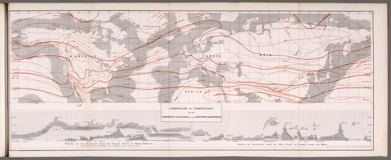
Full Title
Comparison of temperatures for the temperate latitudes of the Northern Hemisphere. (with) Profile of the altitude near the Pacific Coast of North America. (with) Profile of altitude near the West coast of Europe, from the west. Lit. of F. Bourquin & Co., No. 50 South Third St. Philada. (to accompany) Climatology of the United States ...1857.
List No
0083.013
Note
Uncolored map. Showing comparison of temperatures in Northern Hemisphere, from Pacific to coast of China. climatological information shown in red. Shows national boundaries and principle cities.
Author
Blodget, Lorin
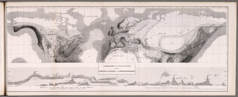
Full Title
Comparison of precipitation for the temperate latitudes of the Northern Hemisphere. (with) Profile of the altitude near the Pacific Coast of North America. (with) Profile of altitude near the West coast of Europe, from the west. Lit. of F. Bourquin & Co., No. 50 South Third St. Philada. (to accompany) Climatology of the United States ...1857.
List No
0083.014
Note
Uncolored map. Showing comparison of precipitation in Northern Hemisphere, from Pacific to coast of China. Shows boundaries and principle cities.
Author
Blodget, Lorin
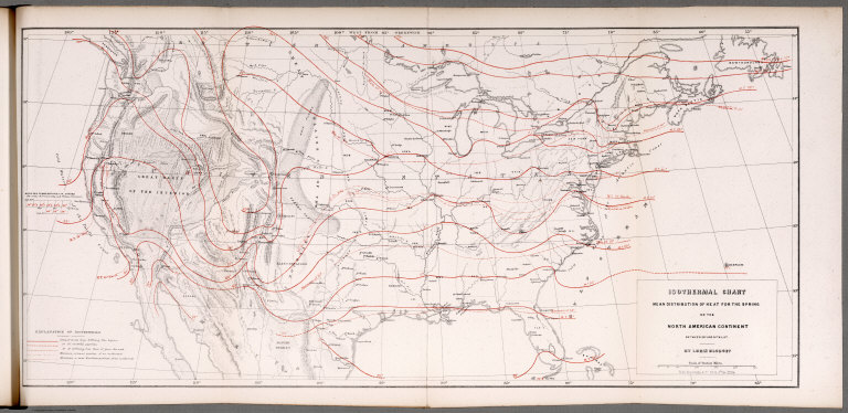
Full Title
Isothermal chart: Mean distribution of heat for the Spring on the North American Continent; between 25 (degrees) and 50 (degrees) N. Lat. By Lorin Blodget. Fred Bourquin & Co., 50 S. 3rd. St. Phila. (to accompany) Climatology of the United States ...1857.
List No
0083.015
Note
Shows average Spring temperature by isothermal lines.. Isothermal lines shown in red. Includes: "Explanation of isothermals", and table of Mean sea temperature in Spring. Shows principle cities, rivers, mountains, etc. Relief shown by hachures.
Author
Blodget, Lorin
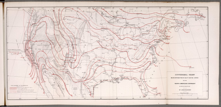
Full Title
Isothermal chart: Mean distribution of heat for the Summer on the North American Continent; between 25 (degrees) and 50 (degrees) N. Lat. By Lorin Blodget. Fred Bourquin & Co., 50 S. 3rd. St. Phila. (to accompany) Climatology of the United States ...1857.
List No
0083.016
Note
Shows average Summer temperature by isothermal lines. Isothermal lines shown in red. Includes: "Explanation of isothermals", and table of Mean sea temperature in Summer. Shows principle cities, rivers, mountains, etc. Relief shown by hachures.
Author
Blodget, Lorin
Full Title
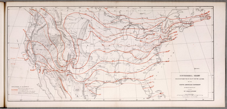
Isothermal chart: Mean distribution of heat for the Autumn on the North American Continent; between 25 (degrees) and 50 (degrees) N. Lat. By Lorin Blodget. Fred Bourquin & Co., 50 S. 3rd. St. Phila. (to accompany) Climatology of the United States ...1857.
List No
0083.017
Note
Shows average Autumn temperature by isothermal lines. Isothermal lines shown in red. Includes: "Explanation of isothermals". Shows principle cities, rivers, mountains, etc. Relief shown by hachures.
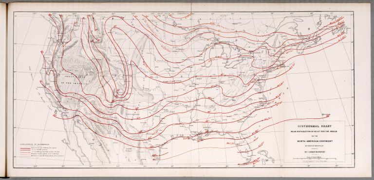
Author
Blodget, Lorin
Full Title
Isothermal chart: Mean distribution of heat for the Winter on the North American Continent; between 25 (degrees) and 50 (degrees) N. Lat. By Lorin Blodget. Fred Bourquin & Co., 50 S. 3rd. St. Phila. (to accompany) Climatology of the United States ...1857.
List No
0083.018
Note
Shows average Winter temperature by isothermal lines. Isothermal lines shown in red. Includes: "Explanation of isothermals". Shows principle cities, rivers, mountains, etc. Relief shown by hachures.
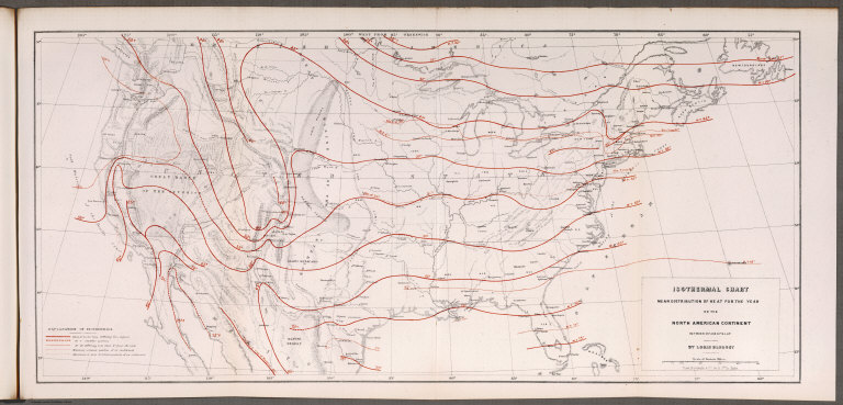
Author
Blodget, Lorin
Full Title
Isothermal chart: Mean distribution of heat for the year on the North American Continent; between 25 (degrees) and 50 (degrees) N. Lat. By Lorin Blodget. Fred Bourquin & Co., 50 S. 3rd. St. Phila. (to accompany) Climatology of the United States ...1857.
List No
0083.019
Note
Shows average annual temperature by isothermal lines.Isothermal lines shown in red. Includes: "Explanation of isothermals". Shows principle cities, rivers, mountains, etc. Relief shown by hachures.
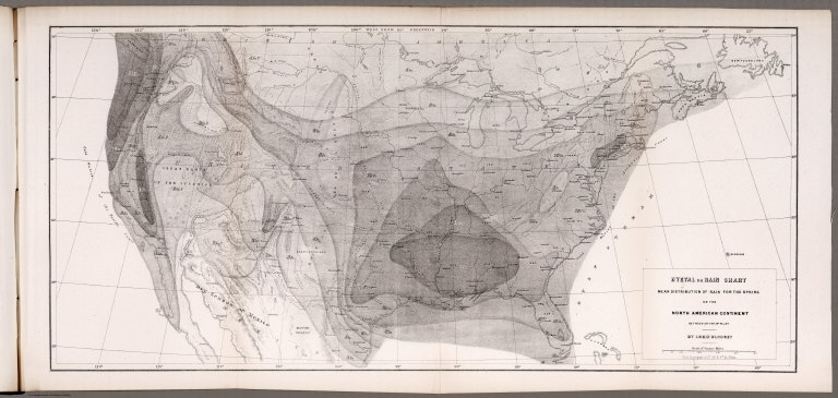
Author
Blodget, Lorin
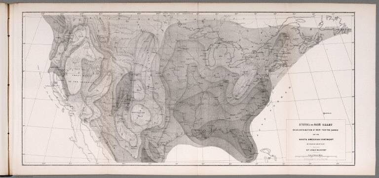
Full Title
Hyetal or rain chart: Mean distribution of rain for the Spring on the North American Continent; between 25 (degrees) and 50 (degrees) N. Lat. By Lorin Blodget. Fred Bourquin & Co., 50 S. 3rd. St. Phila. (to accompany) Climatology of the United States ...1857.
List No
0083.020
Note
Uncolored seasonal rain map. Showing general distribution of rainfall in inches in Spring over North America. Shows principle cities, rivers, mountains, etc. Relief shown by hachures.
Author
Blodget, Lorin
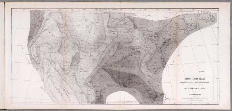
Full Title
Hyetal or rain chart: Mean distribution of rain for the Summer on the North American Continent; between 25 (degrees) and 50 (degrees) N. Lat. By Lorin Blodget. Fred Bourquin & Co., 50 S. 3rd. St. Phila. (to accompany) Climatology of the United States ...1857.
List No
0083.021
Note
Uncolored seasonal rain map. Showing general distribution of rainfall in inches in summer over North America. Shows principle cities, rivers, mountains, etc. Relief shown by hachures.
Author
Blodget, Lorin
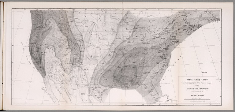
Full Title
Hyetal or rain chart: Mean distribution of rain for the Autumn on the North American Continent; between 25 (degrees) and 50 (degrees) N. Lat. By Lorin Blodget. Fred Bourquin & Co., 50 S. 3rd. St. Phila. (to accompany) Climatology of the United States ...1857.
List No
0083.022
Note
Uncolored seasonal rain map. Showing general distribution of rainfall in inches in Autumn over North America. Shows principle cities, rivers, mountains, etc. Relief shown by hachures.
Author
Blodget, Lorin
Full Title
Hyetal or rain chart: Mean distribution of rain for the Winter on the North American Continent; between 25 (degrees) and 50 (degrees) N. Lat. By Lorin Blodget. Fred Bourquin & Co., 50 S. 3rd. St. Phila. (to accompany) Climatology of the United States ...1857.
List No
0083.023
Note
Uncolored seasonal rain map. Showing general distribution of rainfall in inches in Winter over North America. Shows principle cities, rivers, mountains, etc. Relief shown by hachures.
Author
Blodget, Lorin
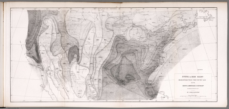
Full Title
Hyetal or rain chart: Mean distribution of rain for the year on the North American Continent; between 25 (degrees) and 50 (degrees) N. Lat. By Lorin Blodget. Fred Bourquin & Co., 50 S. 3rd. St. Phila. (to accompany) Climatology of the United States ...1857.
List No
0083.024
Note
Uncolored seasonal rain map. Showing general distribution of rainfall in inches in year over North America. Shows principle cities, rivers, mountains, etc. Relief shown by hachures.
Author
Maury, Matthew Fontaine, 1806-1873
Full Title
(Title Page to) The Physical Geography of the Sea. By M.F. Maury, LL, D., U.S.N., Superintendent of the National Observatory. An Entirely New Edition, With Addenda. New York: Harper & Brothers, Publishers. London: Sampson Low, Son & Co. 1857. (on verso) Entered ... in the year one thousand eight hundred and fifty-six, by Harper & Brothers ... New York.
List No
0475.001
Note
Maury was one of the first cartographers to study and show winds and currents systematically on charts. The sixth edition, the first being 1855. This was a popular work that went through twelve editions. Maury also made large wind and sea charts of the North Atlantic (15 sheets) and the North Pacific (10 sheets).
Author
Maury, Matthew Fontaine, 1806-1873
Full Title
(Text Page to) The Physical Geography of the Sea. By M.F. Maury, LL, D., U.S.N., Superintendent of the National Observatory. An Entirely New Edition, With Addenda. New York: Harper & Brothers, Publishers. London: Sampson Low, Son & Co. 1857. (on verso) Entered ... in the year one thousand eight hundred and fifty-six, by Harper & Brothers ... New York.
List No
0475.002
Note
Maury was one of the first cartographers to study and show winds and currents systematically on charts. The sixth edition, the first being 1855. This was a popular work that went through twelve editions. Maury also made large wind and sea charts of the North Atlantic (15 sheets) and the North Pacific (10 sheets).
Author
Maury, Matthew Fontaine, 1806-1873
Full Title
(Text Page to) Introduction to the first edition. 1855. (to accompany) The Physical Geography of the Sea. By M.F. Maury. An Entirely New Edition, With Addenda.
List No
0475.003
Note
Maury was one of the first cartographers to study and show winds and currents systematically on charts. The sixth edition, the first being 1855. This was a popular work that went through twelve editions. Maury also made large wind and sea charts of the North Atlantic (15 sheets) and the North Pacific (10 sheets).
Author
Maury, Matthew Fontaine, 1806-1873
Full Title
(Text Page to) Introduction to the first edition. 1855. (to accompany) The Physical Geography of the Sea. By M.F. Maury. An Entirely New Edition, With Addenda.
List No
0475.004
Note
Maury was one of the first cartographers to study and show winds and currents systematically on charts. The sixth edition, the first being 1855. This was a popular work that went through twelve editions. Maury also made large wind and sea charts of the North Atlantic (15 sheets) and the North Pacific (10 sheets).
Author
Maury, Matthew Fontaine, 1806-1873
Full Title
(Text Page to) Introduction to the first edition. 1855. (to accompany) The Physical Geography of the Sea. By M.F. Maury. An Entirely New Edition, With Addenda.
List No
0475.005
Note
Maury was one of the first cartographers to study and show winds and currents systematically on charts. The sixth edition, the first being 1855. This was a popular work that went through twelve editions. Maury also made large wind and sea charts of the North Atlantic (15 sheets) and the North Pacific (10 sheets).
Author
Maury, Matthew Fontaine, 1806-1873
Full Title
(Text Page to) Introduction to the first edition. 1855. (to accompany) The Physical Geography of the Sea. By M.F. Maury. An Entirely New Edition, With Addenda.
List No
0475.006
Note
Maury was one of the first cartographers to study and show winds and currents systematically on charts. The sixth edition, the first being 1855. This was a popular work that went through twelve editions. Maury also made large wind and sea charts of the North Atlantic (15 sheets) and the North Pacific (10 sheets).
Author
Maury, Matthew Fontaine, 1806-1873
Full Title
(Text Page to) Introduction to the first edition. 1855. (and) Introduction to the sixth edition. (to accompany) The Physical Geography of the Sea. By M.F. Maury. An Entirely New Edition, With Addenda.
List No
0475.007
Note
Maury was one of the first cartographers to study and show winds and currents systematically on charts. The sixth edition, the first being 1855. This was a popular work that went through twelve editions. Maury also made large wind and sea charts of the North Atlantic (15 sheets) and the North Pacific (10 sheets).
Author
Maury, Matthew Fontaine, 1806-1873
Full Title
(Text Page to) Introduction to the sixth edition. (to accompany) The Physical Geography of the Sea. By M.F. Maury. An Entirely New Edition, With Addenda.
List No
0475.008
Note
Maury was one of the first cartographers to study and show winds and currents systematically on charts. The sixth edition, the first being 1855. This was a popular work that went through twelve editions. Maury also made large wind and sea charts of the North Atlantic (15 sheets) and the North Pacific (10 sheets).
Author
Maury, Matthew Fontaine, 1806-1873
Full Title
I.The atmosphere. Diagram of the winds. (to accompany) The Physical Geography of the Sea. By M.F. Maury. An Entirely New Edition, With Addenda.
List No
0475.009
Note
Uncolored view illustrate the circulation of the atmosphere.
Author
Maury, Matthew Fontaine, 1806-1873
Full Title
II-III. Brook's deep-sea sounding apparatus. (to accompany) The Physical Geography of the Sea. By M.F. Maury. An Entirely New Edition, With Addenda.
List No
0475.010
Note
View of Brook's deep-sea sounding apparatus, for bringing up specimens of the bottom.
Author
Maury, Matthew Fontaine, 1806-1873
Full Title
IV. Isothermal chart of the Atlantic Ocean for March and September. Pinkney, Sc. (to accompany) The Physical Geography of the Sea. By M.F. Maury. An Entirely New Edition, With Addenda.
List No
0475.011
Note
Uncolored map. Shows extreme movement of the isotherms in the Atlantic Ocean.
Author
Maury, Matthew Fontaine, 1806-1873
Full Title
V. Pilot sheet. D. McClelland, Sc. (to accompany) The Physical Geography of the Sea. By M.F. Maury. An Entirely New Edition, With Addenda.
List No
0475.012
Note
Pilot chart. Shows the method adapted for coordinating the pilot charts, and the winds as reported in the abstract logs.
Author
Maury, Matthew Fontaine, 1806-1873
Full Title
VII. Geological agency of the winds. D. McClelland, Sc. (to accompany) The Physical Geography of the Sea. By M.F. Maury. An Entirely New Edition, With Addenda.
List No
0475.014
Note
Uncolored map. Includes explanation and notes. Shows how the winds may become geological agent.
Author
Maury, Matthew Fontaine, 1806-1873
Full Title
VIII. Winds and routes. (to accompany) The Physical Geography of the Sea. By M.F. Maury. An Entirely New Edition, With Addenda.
List No
0475.015
Note
Uncolored map. Includes explanation. Shows direction of winds during the year in all parts of the ocean, and principal routes across the seas to various places.
Author
Maury, Matthew Fontaine, 1806-1873
Full Title
IX. Sea drift and whales, on which the movements of the sea as indicated by the Thermometer are shown. (to accompany) The Physical Geography of the Sea. By M.F. Maury. An Entirely New Edition, With Addenda.
List No
0475.016
Note
Uncolored map. Includes explanation. Shows the channel of circulation and drift of the ocean with regards to the great flow of polar and equatorial waters.
Author
Maury, Matthew Fontaine, 1806-1873
Full Title
X. August and September Hurricane of 1848. (to accompany) The Physical Geography of the Sea. By M.F. Maury. An Entirely New Edition, With Addenda.
List No
0475.017
Note
Uncolored map. Includes explanation and notes. Shows the path of the storm.
Author
Maury, Matthew Fontaine, 1806-1873
Full Title
XI. Basin of the North Atlantic Ocean. Engraved & printed by J.M. Butler, Philada. (to accompany) The Physical Geography of the Sea. By M.F. Maury. An Entirely New Edition, With Addenda.
List No
0475.018
Note
Uncolored map. Includes inset, explanation and notes. Relief shown by shadings and isolines.
Author
Maury, Matthew Fontaine, 1806-1873
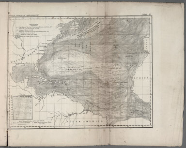
Full Title
XII. Vertical section - North Atlantic Ocean. Engraved & printed by J.M. Butler, Philada. (to accompany) The Physical Geography of the Sea. By M.F. Maury. An Entirely New Edition, With Addenda.
List No
0475.019
Note
Profile of the North Atlantic Ocean, showing the contrast of its bottom with the sea level in various regions.
Author
Maury, Matthew Fontaine, 1806-1873
Full Title
XIII. Storms and rains in North and South Atlantic Ocean. (West Indies not indicted). (to accompany) The Physical Geography of the Sea. By M.F. Maury. An Entirely New Edition, With Addenda.
List No
0475.020
Note
Storm and rain chart, showing the atmosphere is in a more unstable condition in the North than in the South Atlantic ocean.
Author
Perrot, A.M.
Full Title
(Covers to) Carte Pittoresque Et Maritime De La France Indiquant ... Par A.M. Perrot, Revue et augmentee par A. Vuillemin, Paris 1857. Fatout Editeur Boulevard Poissonniere, 17. Chez Fatout ...
List No
0707.002
Author
Stieler, Adolf
Full Title
Stieler's Hand-Atlas ... No. 18. Fluss u. Berg-Karte von Deutschland.
List No
0960.028
Note
Includes east-west and north-south profile drawings. Revised from 1920 edition.
Author
Swann, James G.
Full Title
Map of the Western Portion of Washington Territory. Compiled by J.G. Swan.
List No
0967.000
Note
Removed from "The Northwest Coast." Map is without color. Relief shown by hachures.
Author
Minard, Charles Joseph, 1781-1870
Full Title
(Covers to) Carte figurative et approximative des tonnages de marchandises qui ont circulé en 1855 sur les voies d'eau et fer de l'Empire français. [Flow of merchandise in France on railways and waterways in the year 1855].
List No
10140.001
Note
Folds into covers with label "Tonnages 1855" Robinson, no.12. This map is part of a 9 map subset of the 15 Minard maps that shows the flow of merchandise in France on railways and waterways in the years 1850 to 1861, Pub List No.'s 10138.000 to 10146.000
Author
Minard, Charles Joseph, 1781-1870
Full Title
(Covers to) Carte figurative et approximative des tonnages de marchandises qui ont circulé en 1856 sur les voies d'eau et fer de l'Empire français. [Flow of merchandise in France on railways and waterways in the year 1856].
List No
10141.001
Note
Folds into covers with label "Tonnages 1856" Robinson, no.13. Inscribed by Minard to Charles Didion. Charles Didion (1803-1882) was a French engineer and presumably made Minard's acquaintance at the School for Bridges and Roads, where Didion later became secretary of the general council. This map is part of a 9 map subset of the 15 Minard maps that shows the flow of merchandise in France on railways and waterways in the years 1850 to 1861, Pub List No.'s 10138.000 to 10146.000
Author
Minard, Charles Joseph, 1781-1870
Full Title
(Covers to ) Carte figurative et approximativedes tonnages de marchandises qui ont circulé en 1857 sur les voies d'eau et fer de l'Empire français. [Flow of merchandise in France on railways and waterways in the year 1857].
List No
10142.001
Note
Folds into covers with label "Tonnages 1857" Robinson, no.17. Inscribed by Minard to Charles Didion. Charles Didion (1803-1882) was a French engineer and presumably made Minard's acquaintance at the School for Bridges and Roads, where Didion later became secretary of the general council. This map is part of a 9 map subset of the 15 Minard maps that shows the flow of merchandise in France on railways and waterways in the years 1850 to 1861, Pub List No.'s 10138.000 to 10146.000
Author
[Reymann, Daniel Gottfried, Flemming, Carl]
Full Title
258 Landshut
List No
10605.317
Note
Date is the latest date in the series. The range of dates of the sheets is 1822 to 1865
Author
[Reymann, Daniel Gottfried, Flemming, Carl]
Full Title
283 Schaffhausen
List No
10605.333
Note
Date is the latest date in the series. The range of dates of the sheets is 1822 to 1865
Author
U.S. General Land Office
Full Title
Map of the Public Surveys in California ; to Accompany Report of Surveyor Genl., 1857. Wagner & McGuigan Lith. Phila. Surveyor Generals' Office, San Francisco, California, September 30th, 1857, Approved J.W. Mandeville, U.S. Surr. Genl. Cala.
List No
1073.004
Note
Eleven issues from the Annual Report, (1854,55,56,57,58,59,60,61,62, 63,64). Without color. Scale 18 miles to an inch. Relief shown by hachures. In upper right corner: Sen. Ex. Doc. No. 11 & Ho. Ex. Doc. No. 2, 1st Sess., 35th Cong. Shows list of private Grants finally surveyed, townships, and lands surveyed and proposed to be surveyed. Includes Explanation. (From: Report of the Commissioner of the General Land Office).
Author
U.S. General Land Office
Full Title
Sketch of Public Surveys in New Mexico. To Accompany Report of Surveyor General 1857. Surveyor Generals Office, Santa Fe September 30th. 1857. Wm. Pelham, Surveyor General of New Mexico. C.B. Graham, Lith., Washington D.C.
List No
1076.002
Note
Five issues (1855,57,60,61,63) from the Annual Reports.Uncolored map. Relief shown by hachures. In upper right corner: Sen. Ex. Doc. No. 11 & Ho. Ex. no. 2, 1st sess, 35st. Cong.
Author
U.S. General Land Office
Full Title
Map of a Part of Washington Territory Lying East of the Cascade Mountains : to Accompany Report of Surveyor General. 1857. Surveyor General's Office, Olympia, W. T. September 21st., 1857. James Tilton, Surveyor General.C.B. Graham Lith. Washington D.C.
List No
1079.002
Note
Eleven issues, from the Annual Reports. (1855,57,57,58,59,60,61,62,63, 65,76). (Titles vary). Without color. Scale 12 miles to an inch. Relief shown by hachures. In upper right corner: Sen. Ex. Doc. No. 11 & Ho. Ex. Doc. No. 2, 1st. Sess. 35th Cong.
Author
U.S. General Land Office
Full Title
Map of a That Part of Washington Territory Lying West of the Cascade Mountains : to Accompany Report of Surveyor General. 1857. Surveyor General's Office, Olympia, W. T. September 21st., 1857. James Tilton, Surveyor General. Wagner & McGuigan Lith. Philadelphia.
List No
1079.003
Note
Eleven issues, from the Annual Reports. (1855,57,57,58,59,60,61,62,63, 65,76). (Titles vary). Without color. Relief shown by hachures. In upper right corner: Sen. Ex. Doc. No. 11 & Ho. Ex. Doc. No. 2, 1st. Sess. 35th Cong. Shows roads, trails, lands surveyed and proposed to be surveyed. Includes Explanation.
Author
Wells, John G.
Full Title
(Page 1 of) John G. Wells, Publishing Agent ... Depot for Maps, Charts, Guides, Books & Prints, expressly adapted to the wants of Traveling Agents. 11 Beekman St. N.Y. New Maps and Charts. Suited to the Sales of Agents. ... 1857. (Catalogue of Wells Publications).
List No
1185A
Author
Wells, John G.
Full Title
(Page 2 of) John G. Wells, Publishing Agent ... Depot for Maps, Charts, Guides, Books & Prints, expressly adapted to the wants of Traveling Agents. 11 Beekman St. N.Y. New Maps and Charts. Suited to the Sales of Agents. ... 1857. (Catalogue of Wells Publications).
List No
1185B
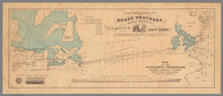
Author
Korff Brothers
Full Title
Map of the Submarine Telegraph between America and Europe, with its various communications on the two continents.
List No
12052.000
Note
Date estimated.
Author
[Ewald, Ludwig 1813-1881, Bauerkeller, Georg Leonhart]
Full Title
No. 4. Mond und Finsternisse.
List No
12189.026
Author
[Ewald, Ludwig 1813-1881, Bauerkeller, Georg Leonhart]
Full Title
No. 13. Veraenderungen der Erdoberflaeche in historischer Zeit.
List No
12189.035
Author
[Ewald, Ludwig 1813-1881, Bauerkeller, Georg Leonhart]
Full Title
No. 21. Dir. Haupt-Sprachenstaemme. Dir. Menschenrassen und die Hauptvoelkerstaemme.
List No
12189.043
Author
[Ewald, Ludwig 1813-1881, Bauerkeller, Georg Leonhart]
Full Title
No. 25. Die Verbreitung der Hauptreligionen auf der Erde.
List No
12189.047
Author
[Ewald, Ludwig 1813-1881, Bauerkeller, Georg Leonhart]
Full Title
No. 67. Kleinasien, Armenien und Syrien.
List No
12189.101
Author
[Ewald, Ludwig 1813-1881, Bauerkeller, Georg Leonhart]
Full Title
No. 68. Ostindien und die ostindischen Inseln.
List No
12189.102
Author
Rodriguez, Eugenio
Full Title
(Covers to) Atlante Della Guida Generale Per La Navigazione Delle Coste Settentrionali Ed Orientali dell'America del Sud dall Rio della Plata al Para accompagnata dalle carte degli atterraggi e dalle piante delle baie, rade, porti, ed entrate de'principali fiumi navigabili ... ; riprodotte sulle migliori e piu recenti di reputati idrografi e navigatori e principalmente su quelle del Barone Roussin ; raccolte durante la Campagna della Fregata l'Urania nell'Oceano Atlantico Australe per Eugenio Rodriguez ..., Napoli 1857.
List No
13048.001
Author
Rodriguez, Eugenio
Full Title
(Index Page to) Atlante Della Guida Generale Per La Navigazione Delle Coste Settentrionali Ed Orientali dell'America del Sud dall Rio della Plata al Para accompagnata dalle carte degli atterraggi e dalle piante delle baie, rade, porti, ed entrate de'principali fiumi navigabili ... ; riprodotte sulle migliori e piu recenti di reputati idrografi e navigatori e principalmente su quelle del Barone Roussin ; raccolte durante la Campagna della Fregata l'Urania nell'Oceano Atlantico Australe per Eugenio Rodriguez ..., Napoli 1857.
List No
13048.003
Author
Rodriguez, Eugenio
Full Title
Carte generale delle coste del Brasile Del Rio del Plata al Para ... No. 1. Anno 1857. Lit. Richter e C. Napoli. (to accompany) Atlante Della Guida Generale Per La Navigazione Delle Coste Settentrionali Ed Orientali dell'America del Sud ... per Eugenio Rodriguez ..., Napoli 1857.
List No
13048.004
Note
Folded nautical chart of the coasts of Brazil, from River Plate to Para. Relief shown by hachures. Depth shown by isolines and soundings. Includes legend and explanation.
Author
Rodriguez, Eugenio
Full Title
Carte generale delle coste del Brasile Del Rio del Plata al Para ... No. 2. Anno 1857. Lit. Richter e C. Napoli. (to accompany) Atlante Della Guida Generale Per La Navigazione Delle Coste Settentrionali Ed Orientali dell'America del Sud ... per Eugenio Rodriguez ..., Napoli 1857.
List No
13048.005
Note
Folded nautical chart of the coasts of Brazil, from River Plate to Para. Relief shown by hachures. Depth shown by isolines and soundings. Includes legend and explanation.
Author
Rodriguez, Eugenio
Full Title
Carte generale delle coste del Brasile Del Rio del Plata al Para ... No. 3. Anno 1857. Lit. Richter e C. Napoli. (to accompany) Atlante Della Guida Generale Per La Navigazione Delle Coste Settentrionali Ed Orientali dell'America del Sud ... per Eugenio Rodriguez ..., Napoli 1857.
List No
13048.006
Note
Folded nautical chart of the coasts of Brazil, from River Plate to Para. Relief shown by hachures. Depth shown by isolines and soundings. Includes legend and explanation.
Author
Rodriguez, Eugenio
Full Title
Carte generale delle coste del Brasile Del Rio del Plata al Para ... No. 4. Anno 1857. Lit. Richter e C. Napoli. (to accompany) Atlante Della Guida Generale Per La Navigazione Delle Coste Settentrionali Ed Orientali dell'America del Sud ... per Eugenio Rodriguez ..., Napoli 1857.
List No
13048.007
Note
Folded nautical chart of the coasts of Brazil, from River Plate to Para. Relief shown by hachures. Depth shown by isolines and soundings. Includes legend and explanation.
Author
Rodriguez, Eugenio
Full Title
Pianta del Rio Grande do sul : su quella levata del Sigr. Dillon Nel. 1849. (to accompany) Atlante Della Guida Generale Per La Navigazione Delle Coste Settentrionali Ed Orientali dell'America del Sud ... per Eugenio Rodriguez ..., Napoli 1857.
List No
13048.008
Note
Folded nautical chart of the Rio Grande, Brazil. Relief shown by hachures. Depth shown by isolines and soundings. Includes legend and explanation.
Author
Rodriguez, Eugenio
Full Title
Pianta del Isola e Dello Stretto di Santa Catarina : su quella del Barral. Publicata del Deposito Generale delle Carte della Marina Francese. Nell' Anno, 1853. (to accompany) Atlante Della Guida Generale Per La Navigazione Delle Coste Settentrionali Ed Orientali dell'America del Sud ... per Eugenio Rodriguez ..., Napoli 1857.
List No
13048.009
Note
Folded nautical chart of the Island and the Strait of Santa Catarina, Brazil. Relief shown by hachures. Depth shown by isolines and soundings. Includes legend and explanation.
Author
Rodriguez, Eugenio
Full Title
Pianta dell' ancoraggio al N.O. dell' Isola Sta. Catarina, su quella levata dal Sigr. Givry. Scala di 7000 Tese. (to accompany) Atlante Della Guida Generale Per La Navigazione Delle Coste Settentrionali Ed Orientali dell'America del Sud ... per Eugenio Rodriguez ..., Napoli 1857.
List No
13048.010
Note
Folded nautical chart of the Strait of Santa Catarina, Brazil. Scala di 7000 Tese (15.5 cm). Relief shown by hachures. Depth shown by isolines and soundings. Includes legend and explanation.
Author
Rodriguez, Eugenio
Full Title
Pianta di Marambaya. Pianta della baia di Paranagua. (to accompany) Atlante Della Guida Generale Per La Navigazione Delle Coste Settentrionali Ed Orientali dell'America del Sud ... per Eugenio Rodriguez ..., Napoli 1857.
List No
13048.011
Note
2 Nautical charts on 1 sheet. Covers Marambia and Parangua, coast of Brazil. Relief shown by hachures. Depth shown by isolines and soundings. Includes legend and explanation.
Author
Rodriguez, Eugenio
Full Title
Carta particolare delle vicinanze dell' Isola San Sebastiao : su quella levata dal Sigri. Givry e Gressier. (to accompany) Atlante Della Guida Generale Per La Navigazione Delle Coste Settentrionali Ed Orientali dell'America del Sud ... per Eugenio Rodriguez ..., Napoli 1857.
List No
13048.012
Note
Folded nautical chart of the of the Sao Sebastiao Island and vicinity. Relief shown by hachures. Depth shown by isolines and soundings. Includes legend and explanation.
Author
Rodriguez, Eugenio
Full Title
Piano dell' angoraggio nell' Isola Sn. Sebastiao : su quella levata dal Sigr. Gressier... 1853. (to accompany) Atlante Della Guida Generale Per La Navigazione Delle Coste Settentrionali Ed Orientali dell'America del Sud ... per Eugenio Rodriguez ..., Napoli 1857.
List No
13048.013
Note
Nautical chart of the Saon Sebastiao Island channel and Anchorage. Scala di miglia marittime (= 6.8 cm). Relief shown by hachures. Depth shown by isolines and soundings. Includes legend and explanation.
Author
Rodriguez, Eugenio
Full Title
Veduta della citta di S. Sebastiano di Rio de Janeiro dll' Isola das Cobras. (to accompany) Atlante Della Guida Generale Per La Navigazione Delle Coste Settentrionali Ed Orientali dell'America del Sud ... per Eugenio Rodriguez ..., Napoli 1857.
List No
13048.017
Note
Panoramic view of the city of Saint Sebastian, Rio de Janeiro from the Island of Cobras.
Author
Rodriguez, Eugenio
Full Title
Selva Sullia Sommita del Corcovado. (to accompany) Atlante Della Guida Generale Per La Navigazione Delle Coste Settentrionali Ed Orientali dell'America del Sud ... per Eugenio Rodriguez ..., Napoli 1857.
List No
13048.018
Note
View of the Selva Sullia Summit of the Corcovado Mountains.
Author
Rodriguez, Eugenio
Full Title
Veduta della Piccola Cascata di Tejuca, wall' atlante di bougainville. (to accompany) Atlante Della Guida Generale Per La Navigazione Delle Coste Settentrionali Ed Orientali dell'America del Sud ... per Eugenio Rodriguez ..., Napoli 1857.
List No
13048.019
Note
View of the Tejuca Waterfall in the Tijuca Forest, a national park.
Author
Rodriguez, Eugenio
Full Title
Veduta del Corcovado : presa dalla casa del console Jnglese. Grob. dos. Lit.Richter e C. in Napoli. (to accompany) Atlante Della Guida Generale Per La Navigazione Delle Coste Settentrionali Ed Orientali dell'America del Sud ... per Eugenio Rodriguez ..., Napoli 1857.
List No
13048.020
Note
View of the Corcovado mountain, in the Tijuca Forest, a national park.
Author
Rodriguez, Eugenio
Full Title
Pianta del Porto di Santos ... 1855. Pianta di porto - Frio ... 1832. (to accompany) Atlante Della Guida Generale Per La Navigazione Delle Coste Settentrionali Ed Orientali dell'America del Sud ... per Eugenio Rodriguez ..., Napoli 1857.
List No
13048.021
Note
2 Nautical charts on one sheet. covers the Port of Santos and Porto-Frio. Relief shown by hachures. Depth shown by isolines and soundings. Includes legend and explanation.
Author
Rodriguez, Eugenio
Full Title
Carta ridotta degli isolotti e del canale degli Abrolhos. (to accompany) Atlante Della Guida Generale Per La Navigazione Delle Coste Settentrionali Ed Orientali dell'America del Sud ... per Eugenio Rodriguez ..., Napoli 1857. (inset) Pianta degli Isolotti Abrolhos o di Santa Barbara.
List No
13048.022
Note
Folded reduced map and chart of Abrolhos Canal. Relief shown by hachures. Depth shown by isolines and soundings. Prime meridian is Paris. Includes legend and explanation.
Author
Rodriguez, Eugenio
Full Title
Pianta della Baia de Espirto Santo : su quella levata dal Sigri. Givry e Gressier nel 1823. (to accompany) Atlante Della Guida Generale Per La Navigazione Delle Coste Settentrionali Ed Orientali dell'America del Sud ... per Eugenio Rodriguez ..., Napoli 1857.
List No
13048.023
Note
Folded nautical chart of the Bay of Espirito Santo, Barazil. Scala di 9 miglia marittime (= 22.5 cm). Relief shown by hachures. Depth shown by soundings. Includes legend and explanation.
Author
Rodriguez, Eugenio
Full Title
Carta ridotta della baia di Todos os Santos : su quella levata dal Sigri. Givry e Gressier nel 1823. (to accompany) Atlante Della Guida Generale Per La Navigazione Delle Coste Settentrionali Ed Orientali dell'America del Sud ... per Eugenio Rodriguez ..., Napoli 1857.
List No
13048.024
Note
Folded reduced map and chart of the bay of Todos os Santos, Barazil. Relief shown by hachures. Depth shown by soundings. Includes legend and explanation. Prime meridian is Paris.
Author
Rodriguez, Eugenio
Full Title
Veduta della citta di San Salvator, o Bahia. Veduta del Faro di Bahia Restan do Pernne. (to accompany) Atlante Della Guida Generale Per La Navigazione Delle Coste Settentrionali Ed Orientali dell'America del Sud ... per Eugenio Rodriguez ..., Napoli 1857.
List No
13048.025
Note
2 panoramic views of the city of San Salvador and of the Lighthouse of Bahia Restando Pernne on 1 sheet.
Author
Rodriguez, Eugenio
Full Title
Pianta del Porto di Macayo o Maceio. Pianta dell' Isola Sant' Aleoxo : su quella levata dal Sigr. C.R.M. Buckle. (to accompany) Atlante Della Guida Generale Per La Navigazione Delle Coste Settentrionali Ed Orientali dell'America del Sud ... per Eugenio Rodriguez ..., Napoli 1857.
List No
13048.026
Note
2 Folded nautical charts on one sheet. Shows Port of Maceio and the Santo Aleixo Island. Scala di 5 Gomene (= 6.2 cm)Relief shown by hachures. Depth shown by soundings. Includes legend and explanation.
Author
Rodriguez, Eugenio
Full Title
Carta ridotta dell' atterraggio e della rada di Pernambuco : su quella levata dal Sigr. Givry. (to accompany) Atlante Della Guida Generale Per La Navigazione Delle Coste Settentrionali Ed Orientali dell'America del Sud ... per Eugenio Rodriguez ..., Napoli 1857.
List No
13048.027
Note
Folded Reduced map of Pernambuco. Relief shown by hachures. Depth shown by soundings. Includes explanation. Prime meridian is Paris.
Author
Rodriguez, Eugenio
Full Title
Pianta della rada di Pernambuco : su quella levata dal Sigr. Gressier. (to accompany) Atlante Della Guida Generale Per La Navigazione Delle Coste Settentrionali Ed Orientali dell'America del Sud ... per Eugenio Rodriguez ..., Napoli 1857.
List No
13048.028
Note
Folded chart of Pernambuco. Relief shown by hachures. Depth shown by soundings. Scala di miglie marine (= 9 cm.) Includes settlements, legend and explanation.
Author
Rodriguez, Eugenio
Full Title
Veduta della citta di Pernambuco : Presa dall ancoraggio della Fregata Napolitana. Veduta della Collina d'Olinda. (to accompany) Atlante Della Guida Generale Per La Navigazione Delle Coste Settentrionali Ed Orientali dell'America del Sud ... per Eugenio Rodriguez ..., Napoli 1857.
List No
13048.029
Note
View of the city of Pernambuco and View of the Collina d'Olinda.
Author
Rodriguez, Eugenio
Full Title
Pianta dello Scoglio di Las-Roccas : su quella levata dall' Uffiziale S.P. Lee. (to accompany) Atlante Della Guida Generale Per La Navigazione Delle Coste Settentrionali Ed Orientali dell'America del Sud ... per Eugenio Rodriguez ..., Napoli 1857.
List No
13048.030
Note
Chart of Las Rocas. Relief shown by hachures. Depth shown by soundings. Scala di 2 miglie marine (= 4.8 cm.) Includes legend and explanation.
Author
Rodriguez, Eugenio
Full Title
Pianta dell' Entrada del Rio Parahyba do Norte : su quella levata dall' Honble ... J.W.R. Jenkins. (to accompany) Atlante Della Guida Generale Per La Navigazione Delle Coste Settentrionali Ed Orientali dell'America del Sud ... per Eugenio Rodriguez ..., Napoli 1857. (inset) Pianta del Rio Jaguarybe. (with) Pianta dello Ancoraggio dei Ciara,
List No
13048.031
Note
Folded chart of the entrance of the Northern Paraiba River. Relief shown by hachures. Depth shown by isolines and soundings. Scala di 2 miglie marine (= 7.8 cm.) Includes legend and explanation.
Author
Rodriguez, Eugenio
Full Title
Pianta delle Isole San Joao : su quella levata dal Comm. C.H.M. Buckle ... (to accompany) Atlante Della Guida Generale Per La Navigazione Delle Coste Settentrionali Ed Orientali dell'America del Sud ... per Eugenio Rodriguez ..., Napoli 1857. (inset) Pianta dell Entrata dello Ancoraggio in piu Larga Scala. (with) Pianta del Rio Grande do Norte.
List No
13048.032
Note
Chart of the San Joao Islands. Relief shown by hachures. Depth shown by isolines and soundings. Scala di 12 miglie marine (= 15 cm.) Includes legend and explanation.
Author
Rodriguez, Eugenio
Full Title
Carta ridotta degli atterraggi del Porto di Maranham : su quella levata Sigr. Givry ... (to accompany) Atlante Della Guida Generale Per La Navigazione Delle Coste Settentrionali Ed Orientali dell'America del Sud ... per Eugenio Rodriguez ..., Napoli 1857. (inset) Pianta del Secco di Manoel Luiz.
List No
13048.033
Note
Folded reduced chart of the port of Maranham. Relief shown by hachures. Depth shown by isolines and soundings. Includes legend and explanation. Prime meridian is Paris.
Author
Rodriguez, Eugenio
Full Title
Pianta della rada e del Porto di Maranham : su quella levata Sigr. Tardy-d Montravel. (to accompany) Atlante Della Guida Generale Per La Navigazione Delle Coste Settentrionali Ed Orientali dell'America del Sud ... per Eugenio Rodriguez ..., Napoli 1857.
List No
13048.034
Note
Folded chart of the port of Maranham. Scala di due miglie marine (= 10.3 cm.) Relief shown by hachures. Depth shown by isolines and soundings. Includes legend and explanation.
Author
Rodriguez, Eugenio
Full Title
Carta generale dell Riviera del para e suoi atterraggi : su quella levata Sigr. Tardy-d Montravel. (to accompany) Atlante Della Guida Generale Per La Navigazione Delle Coste Settentrionali Ed Orientali dell'America del Sud ... per Eugenio Rodriguez ..., Napoli 1857.
List No
13048.035
Note
Folded chart of the Para River. Relief shown by hachures. Depth shown by isolines and soundings. Includes legend and table.
Author
Rodriguez, Eugenio
Full Title
Pianta del Porto di Vigia (Riviera del Para) : su quella levata Sigri. Le-Serrec ... (to accompany) Atlante Della Guida Generale Per La Navigazione Delle Coste Settentrionali Ed Orientali dell'America del Sud ... per Eugenio Rodriguez ..., Napoli 1857.
List No
13048.036
Note
Folded chart of the Vigia port, Para River. Scala di due miglie marine (= 8.3 cm.). Relief shown by hachures. Depth shown by isolines and soundings. Includes legend and table.
Author
Rodriguez, Eugenio
Full Title
Carta ridotta del corso della Riviera dello Amazzone : su quella levata Sigr. Tardy-d Montravel. (to accompany) Atlante Della Guida Generale Per La Navigazione Delle Coste Settentrionali Ed Orientali dell'America del Sud ... per Eugenio Rodriguez ..., Napoli 1857.
List No
13048.037
Note
Reduced folded chart of the course of the Amazon River region. Relief shown by hachures. Depth shown by isolines and soundings. Includes legend and table.
Author
Rodriguez, Eugenio
Full Title
Carta generale dell'Arcipelago delle Azore : su quella levata Capo. A.T.E. Vidal. (to accompany) Atlante Della Guida Generale Per La Navigazione Delle Coste Settentrionali Ed Orientali dell'America del Sud ... per Eugenio Rodriguez ..., Napoli 1857.
List No
13048.038
Note
Folded map of the Archipelago of Azores. With 4 insets : Pianta della Baia d'Horta; Pianta della Rada d'Angra; Pianta della Baia di Porta Delgada; Pianta de las Formigas, e del Sacco di Dollabarats. Relief shown by hachures. Depth shown by isolines and soundings. Includes notes. Prime meridian is Paris.
Author
Baur, Carl Friedrich
Full Title
(Covers to) Atlas fur Handel u. Industrie, fur Kaufleute, Fabrikanten u. Gewerbetreibende, Handlungs-u. Gewerbe-Schulen, polytechnische Lehr-Anstalten etc., entworfen, gezeichnet und mit erlauternden Notizen versehen von C.F. Baur. Mannheim 1857. Verlagsbuchhandlung von Friedrich Bassermann. Litho. v. B. Walter Stuttgart.
List No
13199.001
Author
Baur, Carl Friedrich
Full Title
(Text Page to) Vorwort : Atlas fur Handel u. Industrie, fur Kaufleute, Fabrikanten u. Gewerbetreibende, Handlungs-u. Gewerbe-Schulen, polytechnische Lehr-Anstalten etc., entworfen, gezeichnet und mit erlauternden Notizen versehen von C.F. Baur. Mannheim 1857. Verlagsbuchhandlung von Friedrich Bassermann. Litho. v. B. Walter Stuttgart.
List No
13199.003
Note
Forward: By the author
Author
Baur, Carl Friedrich
Full Title
(Text Page to) Erd - Karte. (to accompany) Atlas fur Handel u. Industrie, fur Kaufleute, Fabrikanten u. Gewerbetreibende ... von C.F. Baur. Mannheim 1857.
List No
13199.004
Note
Text to plate 1, world map.
Author
Baur, Carl Friedrich
Full Title
(Text Page to) Grossbritannien. (to accompany) Atlas fur Handel u. Industrie, fur Kaufleute, Fabrikanten u. Gewerbetreibende ... von C.F. Baur. 1857.
List No
13199.006
Note
Text to plate 2, Great Britain.
Author
Baur, Carl Friedrich
Full Title
(Text Page to) Frankreich. (to accompany) Atlas fur Handel u. Industrie, fur Kaufleute, Fabrikanten u. Gewerbetreibende ... von C.F. Baur. 1857.
List No
13199.008
Note
Text to Plate 3. France.
Author
Baur, Carl Friedrich
Full Title
(Text Page to) Osterreich. (to accompany) Atlas fur Handel u. Industrie, fur Kaufleute, Fabrikanten u. Gewerbetreibende ... von C.F. Baur. 1857.
List No
13199.010
Note
Text to Plate 5, Austria. Plate 5 bound before plate 4.
Author
Baur, Carl Friedrich
Full Title
(Text Page to) Osterreich. (to accompany) Atlas fur Handel u. Industrie, fur Kaufleute, Fabrikanten u. Gewerbetreibende ... von C.F. Baur. 1857.
List No
13199.011
Note
Continues text to plate 5. Austria. Plate 5 bound before plate 4.
Author
Baur, Carl Friedrich
Full Title
Osterreich. Entworfen u. gezeichnet v. C. F. Baur. Bassermann Verlagshandlung in Mannheim. (to accompany) Atlas fur Handel u. Industrie, fur Kaufleute, Fabrikanten u. Gewerbetreibende ... von C.F. Baur. 1857.
List No
13199.012
Note
Color map, with inset map of Wiens Umgebung. Shows major cities, roads, railroads, and shipping routes. Includes reference to agricultural, mineral and industrial products, and table of import and export. Includes note.
Author
Baur, Carl Friedrich
Full Title
(Text Page to) Russland. (to accompany) Atlas fur Handel u. Industrie, fur Kaufleute, Fabrikanten u. Gewerbetreibende ... von C.F. Baur. 1857.
List No
13199.013
Note
Text to plate 4, Russia. Plate 4 bound after plate 5.
Author
Baur, Carl Friedrich
Full Title
(Text Page to) Russland. (to accompany) Atlas fur Handel u. Industrie, fur Kaufleute, Fabrikanten u. Gewerbetreibende ... von C.F. Baur. 1857.
List No
13199.014
Note
Continues text to plate 4. Russia. Plate 4 bound after plate 5.
Author
Baur, Carl Friedrich
Full Title
Russland. Entworfen u. gezeichnet v. C. F. Baur. Bassermann Verlagshandlung in Mannheim. (to accompany) Atlas fur Handel u. Industrie, fur Kaufleute, Fabrikanten u. Gewerbetreibende ... von C.F. Baur. 1857.
List No
13199.015
Note
Color map, with inset map of Umgebung St. Petersburg. Shows major cities, roads, railroads, and shipping routes. Includes reference to agricultural, mineral and industrial products, and table of import and export.
Author
Baur, Carl Friedrich
Full Title
(Text Page to) Der Preussische-Deutsche Zollverein. (to accompany) Atlas fur Handel u. Industrie, fur Kaufleute, Fabrikanten u. Gewerbetreibende ... von C.F. Baur. 1857.
List No
13199.016
Note
Text to Plate 6. German states.
Author
Baur, Carl Friedrich
Full Title
(Text Page to) Der Preussische-Deutsche Zollverein. (to accompany) Atlas fur Handel u. Industrie, fur Kaufleute, Fabrikanten u. Gewerbetreibende ... von C.F. Baur. 1857.
List No
13199.017
Note
Continues double page text to Plate 6. German states.
Author
Baur, Carl Friedrich
Full Title
(Text Page to) Der Preussische-Deutsche Zollverein. (to accompany) Atlas fur Handel u. Industrie, fur Kaufleute, Fabrikanten u. Gewerbetreibende ... von C.F. Baur. 1857.
List No
13199.018
Note
Continues double page text to Plate 6. German states.
Author
Baur, Carl Friedrich
Full Title
(Text Page to) Der Preussische-Deutsche Zollverein. (to accompany) Atlas fur Handel u. Industrie, fur Kaufleute, Fabrikanten u. Gewerbetreibende ... von C.F. Baur. 1857.
List No
13199.019
Note
Continues text to Plate 6. German states.
Author
Baur, Carl Friedrich
Full Title
Der Preussische-Deutsche Zollverein. Entworfen u. gezeichnet v. C. F. Baur. Bassermannsche Verlagshandlung in Mannheim. Walther lith. (to accompany) Atlas fur Handel u. Industrie, fur Kaufleute, Fabrikanten u. Gewerbetreibende ... von C.F. Baur. 1857.
List No
13199.020
Note
Color map. Shows major cities, roads, railroads, and shipping routes. Includes reference to agricultural, mineral and industrial products, and table of import and export.
Author
Baur, Carl Friedrich
Full Title
(Text Page to) Die Schweiz. (to accompany) Atlas fur Handel u. Industrie, fur Kaufleute, Fabrikanten u. Gewerbetreibende ... von C.F. Baur. 1857.
List No
13199.021
Note
Text to Plate 7. Switzerland.
Author
Baur, Carl Friedrich
Full Title
(Text Page to) Die Schweiz. (to accompany) Atlas fur Handel u. Industrie, fur Kaufleute, Fabrikanten u. Gewerbetreibende ... von C.F. Baur. 1857.
List No
13199.022
Note
Continues text to Plate 7. Switzerland.
Author
Baur, Carl Friedrich
Full Title
Die Schweiz. Entworfen u. gezeichnet v. C. F. Baur. Bassermannsche Verlagshandlung in Mannheim. B. Walther lith. (to accompany) Atlas fur Handel u. Industrie, fur Kaufleute, Fabrikanten u. Gewerbetreibende ... von C.F. Baur. 1857.
List No
13199.023
Note
Color map. Shows major cities, roads, railroads, and shipping routes. Includes reference to agricultural, mineral and industrial products, and table of import and export. Includes list of major cities.
Author
Baur, Carl Friedrich
Full Title
(Text Page to) Die Rhinlander. Holland und Belgien. (to accompany) Atlas fur Handel u. Industrie, fur Kaufleute, Fabrikanten u. Gewerbetreibende ... von C.F. Baur. 1857.
List No
13199.024
Note
Text to Plate 8. Netherlands and Belgium.
Author
Baur, Carl Friedrich
Full Title
(Text Page to) Die Rhinlander. Holland und Belgien. (to accompany) Atlas fur Handel u. Industrie, fur Kaufleute, Fabrikanten u. Gewerbetreibende ... von C.F. Baur. 1857.
List No
13199.025
Note
Continues text to Plate 8. Netherlands and Belgium.
Author
Baur, Carl Friedrich
Full Title
Die Rhinlander. Entworfen u. gezeichnet v. C. F. Baur. Bassermannsche Verlagshandlung in Mannheim. Walther lith. (to accompany) Atlas fur Handel u. Industrie, fur Kaufleute, Fabrikanten u. Gewerbetreibende ... von C.F. Baur. 1857.
List No
13199.026
Note
Color map, with color coded reference. Shows major cities, roads, railroads, and shipping routes. Includes reference to agricultural, mineral and industrial products, and table of import and export.
Author
Baur, Carl Friedrich
Full Title
(Text Page to) Skandinavien. (to accompany) Atlas fur Handel u. Industrie, fur Kaufleute, Fabrikanten u. Gewerbetreibende ... von C.F. Baur. 1857.
List No
13199.027
Note
Text to plate 9. Scandinavia.
Author
Baur, Carl Friedrich
Full Title
(Text Page to) kandinavien. (to accompany) Atlas fur Handel u. Industrie, fur Kaufleute, Fabrikanten u. Gewerbetreibende ... von C.F. Baur. 1857.
List No
13199.028
Note
Continues Text to plate 9, Scandinavia.
Author
Baur, Carl Friedrich
Full Title
Schweden und Norwegen. Entworfen u. gezeichnet v. C. F. Baur. Bassermannsche Verlagshandlung in Mannheim. Walther lith. (to accompany) Atlas fur Handel u. Industrie, fur Kaufleute, Fabrikanten u. Gewerbetreibende ... von C.F. Baur. 1857.
List No
13199.029
Note
Color map, with color coded reference. Shows major cities, roads, railroads, and shipping routes. Includes reference to agricultural, mineral and industrial products, and table of import and export.
Author
Baur, Carl Friedrich
Full Title
(Text Page to) Mecklenburg. Der Danische Zollverein und die Hansestadte. (to accompany) Atlas fur Handel u. Industrie, fur Kaufleute, Fabrikanten u. Gewerbetreibende ... von C.F. Baur. 1857.
List No
13199.030
Note
Text to Plate 10.
Author
Baur, Carl Friedrich
Full Title
(Text Page to) Mecklenburg. Der Danische Zollverein und die Hansestadte. (to accompany) Atlas fur Handel u. Industrie, fur Kaufleute, Fabrikanten u. Gewerbetreibende ... von C.F. Baur. 1857.
List No
13199.031
Note
Continues text to Plate 10.
Author
Baur, Carl Friedrich
Full Title
Mecklenburg. Der Daenische Zollverein und die Hansestadte. Entworfen u. gezeichnet v. C. F. Baur. Bassermannsche Verlagshandlung in Mannheim. Walther lith. (to accompany) Atlas fur Handel u. Industrie, fur Kaufleute, Fabrikanten u. Gewerbetreibende ... von C.F. Baur. 1857.
List No
13199.032
Note
Color map, with insets: Island and Far Oer. Includes color coded reference. Shows major cities, roads, railroads, and shipping routes. Includes reference to agricultural, mineral and industrial products, and table of import and export.
Author
Baur, Carl Friedrich
Full Title
(Text Page to) Das Mittellandische Meer. Die Spanische und Italische Halbnsel, Marocco, Algier etc. (Zu karte XIa). (to accompany) Atlas fur Handel u. Industrie, fur Kaufleute, Fabrikanten u. Gewerbetreibende ... von C.F. Baur. 1857.
List No
13199.033
Note
Text to Plate 11, Mediterranean Sea.
Author
Baur, Carl Friedrich
Full Title
(Text Page to) Das Mittellandische Meer. Die Spanische und Italische Halbnsel, Marocco, Algier etc. (Zu karte XIa). (to accompany) Atlas fur Handel u. Industrie, fur Kaufleute, Fabrikanten u. Gewerbetreibende ... von C.F. Baur. 1857.
List No
13199.034
Note
Continues double page text to Plate 11, Mediterranean Sea.
Author
Baur, Carl Friedrich
Full Title
(Text Page to) Das Mittellandische Meer. Die Spanische und Italische Halbnsel, Marocco, Algier etc. (Zu karte XIa). (to accompany) Atlas fur Handel u. Industrie, fur Kaufleute, Fabrikanten u. Gewerbetreibende ... von C.F. Baur. 1857.
List No
13199.035
Note
Continues text to Plate 11a, Mediterranean Sea.
Author
Baur, Carl Friedrich
Full Title
Das Mittellaendische Meer. Bl. XIa. Entworfen u. gezeichnet v. C. F. Baur. Bassermannsche Verlagshandlung in Mannheim. (to accompany) Atlas fur Handel u. Industrie, fur Kaufleute, Fabrikanten u. Gewerbetreibende ... von C.F. Baur. 1857.
List No
13199.036
Note
Color map, sheet 1 of 2 sheets a & b. Shows political divisions, major cities, roads, railroads, and shipping routes. Includes reference to agricultural, mineral and industrial products, and table of import and export.
Author
Baur, Carl Friedrich
Full Title
(Text Page to) Mittellandische Meer. Turkisches Reich. (Zu karte XIb). (to accompany) Atlas fur Handel u. Industrie, fur Kaufleute, Fabrikanten u. Gewerbetreibende ... von C.F. Baur. 1857.
List No
13199.037
Note
Text to Plate 11b, Mediterranean Sea.
Author
Baur, Carl Friedrich
Full Title
(Text Page to) Mittellandische Meer. Turkisches Reich. (Zu karte XIb). (to accompany) Atlas fur Handel u. Industrie, fur Kaufleute, Fabrikanten u. Gewerbetreibende ... von C.F. Baur. 1857.
List No
13199.038
Note
Continues double page text to Plate 11b, Mediterranean Sea.
Author
Baur, Carl Friedrich
Full Title
Das Mittellaendische Meer. Bl. XIb. Entworfen u. gezeichnet v. C. F. Baur. Bassermannsche Verlagshandlung in Mannheim. (to accompany) Atlas fur Handel u. Industrie, fur Kaufleute, Fabrikanten u. Gewerbetreibende ... von C.F. Baur. 1857.
List No
13199.039
Note
Color map, sheet 2 of 2 sheets a & b. Shows political divisions, major cities, roads, railroads, and shipping routes. Includes reference to agricultural, mineral and industrial products, and table of import and export.
Author
Baur, Carl Friedrich
Full Title
(Composite of) Mittellaendische Meer. Bl. XIa-Bl XIb. (to accompany) Atlas fur Handel u. Industrie, fur Kaufleute, Fabrikanten u. Gewerbetreibende ... von C.F. Baur. 1857.
List No
13199.040
Note
Composite map of sheets 11 a and 11 b. Mediterranean Sea Region.
Author
Baur, Carl Friedrich
Full Title
(Text Page to) Westindien. (to accompany) Atlas fur Handel u. Industrie, fur Kaufleute, Fabrikanten u. Gewerbetreibende ... von C.F. Baur. 1857.
List No
13199.041
Note
Text to Plate 12, West Indies.
Author
Baur, Carl Friedrich
Full Title
(Text Page to) Westindien. (to accompany) Atlas fur Handel u. Industrie, fur Kaufleute, Fabrikanten u. Gewerbetreibende ... von C.F. Baur. 1857.
List No
13199.042
Note
Continues text to Plate 12, West Indies.
Author
Baur, Carl Friedrich
Full Title
Westindien. Entworfen u. gezeichnet v. C. F. Baur. Bassermannsche Verlagshandlung in Mannheim. (to accompany) Atlas fur Handel u. Industrie, fur Kaufleute, Fabrikanten u. Gewerbetreibende ... von C.F. Baur. 1857.
List No
13199.043
Note
Color map, with inset map of Havanna. Includes color coded reference. Shows political divisions, major cities, roads, railroads, and shipping routes. Includes reference to agricultural, mineral and industrial products, and table of import and export.
Author
Baur, Carl Friedrich
Full Title
(Text Page to) Sud-Amerika. (to accompany) Atlas fur Handel u. Industrie, fur Kaufleute, Fabrikanten u. Gewerbetreibende ... von C.F. Baur. 1857.
List No
13199.044
Note
Text to Plate 13, South America.
Author
Baur, Carl Friedrich
Full Title
(Text Page to) Sud-Amerika. (to accompany) Atlas fur Handel u. Industrie, fur Kaufleute, Fabrikanten u. Gewerbetreibende ... von C.F. Baur. 1857.
List No
13199.045
Note
Continues text to Plate 13, South America.
Author
Baur, Carl Friedrich
Full Title
Sud-Amerika. Entworfen u. gezeichnet v. C. F. Baur. Bassermannsche Verlagshandlung in Mannheim. B. Walther lith. (to accompany) Atlas fur Handel u. Industrie, fur Kaufleute, Fabrikanten u. Gewerbetreibende ... von C.F. Baur. 1857.
List No
13199.046
Note
Color map. Includes color coded reference. Shows political divisions, major cities, and shipping routes. Includes reference to agricultural, mineral and industrial products, and table of import and export.
|


![[Europe.]](https://www.davidrumsey.com/rumsey/Size2/RUMSEY~8~1/213/14489003.jpg)
![[Europe.]](https://www.davidrumsey.com/rumsey/Size2/RUMSEY~8~1/213/14489004.jpg)


![[France.]](https://www.davidrumsey.com/rumsey/Size2/RUMSEY~8~1/213/14489021.jpg)
![[Armorican Massif, France.]](https://www.davidrumsey.com/rumsey/Size2/RUMSEY~8~1/213/14489025.jpg)
![[Loire River.]](https://www.davidrumsey.com/rumsey/Size2/RUMSEY~8~1/213/14489026.jpg)
![[Loire River.]](https://www.davidrumsey.com/rumsey/Size2/RUMSEY~8~1/213/14489027.jpg)


![[North and South America.]](https://www.davidrumsey.com/rumsey/Size2/RUMSEY~8~1/213/14489044.jpg)
![[South America.]](https://www.davidrumsey.com/rumsey/Size2/RUMSEY~8~1/213/14489045.jpg)