|
Author
Brown & Parsons
Full Title
Map of Connecticut. From Actual Survey. Published by Brown & Parsons, Hartford, Conn. Engraved by Daggett & Ely New Haven. (inset) Plan of the City of New Haven. (inset) Plan of the City of Hartford. (inset) New England States.
List No
0095.002
Note
Engraved by Daggett & Ely, New Haven. Editions of 1827, 1831, 1836, 1847, 1854, 1858. Map is folded into dark brown cloth covers 13.5x8.5 with "Map Of Connecticut" in gilt. Includes references, and chronological list of "Governors of Connecticut. since the Charter. 1676-1850." Relief shown by hachures. Prime meridian is Greenwich.
Author
Colton, J. H.
Full Title
(Covers to) Illinois. Published By J.H. Colton No. 86 Cedar St. New York. 1854. Entered ... 1853, by J.H. Colton ... New York. (inset) Vicinity of Chicago.
List No
0176.001
Note
Third edition, first edition being 1852. "Traveling Maps" series, with census data on verso. Earlier than the 1855 American Atlas Illinois, with fewer railroads. Folded into red cloth covers 12.5x9 with "Map Of Illinois J.H. Colton" stamped in gilt. Full color. Prime meridians are Greenwich and Washington D.C.
Author
Colton, J. H.
Full Title
Illinois. Published By J.H. Colton No. 86 Cedar St. New York. 1854. Entered ... 1853, by J.H. Colton ... New York. (inset) Vicinity of Chicago.
List No
0176.002
Note
Third edition, first edition being 1852. "Traveling Maps" series, with census data on verso. Earlier than the 1855 American Atlas Illinois, with fewer railroads. Folded into red cloth covers 12.5x9 with "Map Of Illinois J.H. Colton" stamped in gilt. Full color. Prime meridians are Greenwich and Washington D.C.
Author
Colton, J. H.
Full Title
(Covers to) Colton's New Map Of Indiana. Reduced from his Large Map Exhibiting the Boundaries of Counties, Township Surveys, Location of Cities, Towns, Villages, Post Offices, Canals, Rail Roads & other Internal Improvements. New-York, Published by J.H. Colton & Co. 1854. Entered ... 1854, by J.H. Colton ... New York.
List No
0178.001
Note
This is the second edition of this map, issued for Colton's "Travelling Maps" series, with a new vine border that is changed from the first edition, but still with the locator key. Folded into patterned black cloth covers 12.5x8.5 with "Map Of Indiana J.H. Colton" in gilt. Prime meridian is Washington D.C.
Author
Colton, J. H.
Full Title
Colton's New Map Of Indiana. Reduced from his Large Map Exhibiting the Boundaries of Counties, Township Surveys, Location of Cities, Towns, Villages, Post Offices, Canals, Rail Roads & other Internal Improvements. New-York, Published by J.H. Colton & Co. 1854. Entered ... 1854, by J.H. Colton ... New York.
List No
0178.002
Note
This is the second edition of this map, issued for Colton's "Travelling Maps" series, with a new vine border that is changed from the first edition, but still with the locator key. Folded into patterned black cloth covers 12.5x8.5 with "Map Of Indiana J.H. Colton" in gilt. Prime meridian is Washington D.C.
Author
Dodge, J.R.
Full Title
(Covers to) Township and Railroad Map Of New Hampshire, Compiled from the best authorities ... 1854. Published by J.R. Dodge, Nashua, N.H. L.H. Bradford & Co.'s Boston. Entered ... 1854 by J.R. Dodge ... New Hampshire.
List No
0246.001
Note
1st edition, four vignette views. Shows extensive railroad building throughout the state. Map is full color by county, folded into embossed dark brown cloth covers with "Dodge's Map Of New Hampshire" in gold.
Author
Dodge, J.R.
Full Title
Township and Railroad Map Of New Hampshire, Compiled from the best authorities ... 1854. Published by J.R. Dodge, Nashua, N.H. L.H. Bradford & Co.'s Boston. Entered ... 1854 by J.R. Dodge ... New Hampshire.
List No
0246.002
Note
1st edition, four vignette views. Shows extensive railroad building throughout the state. Map is full color by county, folded into embossed dark brown cloth covers with "Dodge's Map Of New Hampshire" in gold. With Table of "Statistics of the New Hampshire", table showing counties, population, valuation, acres of land, manufactories, etc., and explanation. Relief shown by hachures.
Author
[Forbes, Edward, 1815-1854, Johnston, Alexander Keith, 1804-1871]
Full Title
(Covers to) & Palaeontological Map Of The British Islands. By A.K. Johnston, F.R.G.S. From the Sketches & Notes of Professor Edward Forbes F.R.S. Of Kings College London & Of The Government School Of Mines. President Of The Geological Society. Physical Atlas. Geology No. 5. Plate 5. William Blackwood & Sons, Edinburgh & London. Engraved by W. & A.K. Johnston.
List No
0371A
Note
Separately issued plate from the Physical Atlas. Printed in full color. Map is dissected into 12 sections, edged in red cloth and mounted on linen. Folds into black leather covers 28x23.5 with "Palaeontological Map Of The British Islands" stamped in gilt.
Author
[Forbes, Edward, 1815-1854, Johnston, Alexander Keith, 1804-1871]
Full Title
Geological & Palaeontological Map Of The British Islands. By A.K. Johnston, F.R.G.S. From the Sketches & Notes of Professor Edward Forbes F.R.S. Of Kings College London & Of The Government School Of Mines. President Of The Geological Society. Physical Atlas. Geology No. 5. Plate 5. William Blackwood & Sons, Edinburgh & London. Engraved by W. & A.K. Johnston.
List No
0371.001
Note
Separately issued plate from the Physical Atlas. Printed in full color. Map is dissected into 12 sections, edged in red cloth and mounted on linen. Folds into black leather covers 28x23.5 with "Palaeontological Map Of The British Islands" stamped in gilt.
Author
Johnston, Alexander Keith, 1804-1871
Full Title
The mountain systems of Europe constructed on the basis of contour lines. From the drawings of Professor Berghaus, Berlin. By A.K. Johnston, F.R.S.E. Engraved by W. & A.K. Johnston. William Blackwood & Sons, Edinburgh & London. 1st. Nov. 1854, (1856)
List No
0372.003
Note
Hand col. lithographed map. Relief shown by contours and hachures. 6 mountain systems outlined in color. "Geology no. 3."
Author
[Forbes, Edward, 1815-1854, Johnston, Alexander Keith, 1804-1871]
Full Title
Geological & palaeontological map of the British Islands. By A.K. Johnston, F.R.G.S. From the sketches & notes of Professor Edward Forbes, F.R.S. of Kings College London & of the Government School of Mines, President of the Geological Society. Engraved by W. & A.K. Johnston. William Blackwood & Sons, Edinburgh & London. 1st March 1854, (1856)
List No
0372.005
Note
Col. lithographed map. Northern half covering Scotland and parts of Ireland, Northern Ireland and England. Explanation on pl. 6. Includes inset of the Shetland Islands, tables, and illustrations of "Palaeozoic fishes," "Tertiary & post Tertiary Mamallia," and "Secondary reptiles." "Geology no. 5."
Author
[Forbes, Edward, 1815-1854, Johnston, Alexander Keith, 1804-1871]
Full Title
Palaeontological map (British Islands. By A.K. Johnston, F.R.G.S. From the sketches & notes of Professor Edward Forbes, F.R.S. of Kings College London & of the Government School of Mines, President of the Geological Society). Engraved by W. & A.K. Johnston. William Blackwood & Sons, Edinburgh & London. 1st March 1854, (1856)
List No
0372.006
Note
Col. lithographed map. Southern half of "Geological & palaeontological map of the British Islands." Covers Wales and most of England and Ireland. Shows 25 geologic units. Includes notes, tables and illustrations: Types of groups of Ammonites ... after Von Buch & D'Orbigny." "Geology no. 6."
Author
[Forbes, Edward, 1815-1854, Johnston, Alexander Keith, 1804-1871]
Full Title
(Composite of) Geological & palaeontological map of the British Islands. By A.K. Johnston, F.R.G.S. From the sketches & notes of Professor Edward Forbes, F.R.S. of Kings College London & of the Government School of Mines, President of the Geological Society. Engraved by W. & A.K. Johnston. William Blackwood & Sons, Edinburgh & London. 1st March 1854, (1856)
List No
0372.007
Note
Col. lithographed map on 2 sheets. Southern sheet entitled: Palaeontological map. Shows 25 geologic units. Includes inset of the Shetland Islands, notes, tables, and illustrations of "Palaeozoic fishes," "Tertiary & post Tertiary Mamallia," and "Secondary reptiles, " and "Types of groups of Ammonites ... after Von Buch & D'Orbigny." "Geology no. 5. ... no. 6."
Author
[Charpentier, Jean de, 1786-1855, Forbes, Edward, 1815-1854, Johnston, Alexander Keith, 1804-1871]
Full Title
Illustrations of the glacier systems of the Alps and of glacial phenomena in general. From the surveys and sketches of Professor Forbes, the maps of Raymond, Weiss, Charpentier &c., by A.K. Johnston, F.R.S.E. Engraved by W. & A.K. Johnston. William Blackwood & Sons, Edinburgh & London. 1st. November 1854. (1856)
List No
0372.010
Note
Four col. maps on 1 sheet. Includes 4 inset maps and 2 diagrams. Contents: Map of the glacier system of Mont Blanc. Scale (ca. 1:120,000) -- Map of the snow-field glaciers of the Bernese Oberland. Scale (ca. 1:120,000) -- Sketch of part of the Mer de Glace of Chamouni -- Map of the limits of the erratic deposit of the valley of the Rhone by J. de Charpentier -- Eye sketch of the glacier of Miace -- Eye sketch of the glacier of Allalein in the valley of Saas -- Sketch of the glacier of Talefre -- Eye sketch of the glacier of Schonhorn near the Simplon -- Sketch showing the actual elevation of the snow line in different latitudes from the Equator to the poles -- Diagram showing the actual slope of the Mer de Glace, and its tributaries. "Geology no. 9."
Author
[Johnston, Alexander Keith, 1804-1871, Russell, J. Scott (John Scott), 1808-1882]
Full Title
Tidal chart of the British Seas. Showing the progress of the wave of high water, the hour of high water in Greenwich time at new and full moon; and the depth of the sea. Constructed under the direction of J. Scott Russell, Esqr., F.R.S., ED. by A.K. Johnston, F.R.G.S. Engraved by W. & A.K. Johnston. William Blackwood & Sons, Edinburgh & London. 1 Nov. 1854. (1856)
List No
0372.016
Note
Hand col. lithograph. Depths shown by bathymetric tints. "Hydrology no. 4."
Author
Johnston, Alexander Keith, 1804-1871
Full Title
Geographical distribution of the currents of air, showing the regions of the trade winds, variable winds and hurricanes, with their effects in determining the different tracks of navigation by A.K. Johnston, F.R.S.E. Engraved & printed in colours by W. & A.K. Johnston, Edinburgh. William Blackwood & Sons, Edinburgh & London. 1st. March 1854. (1856)
List No
0372.020
Note
Col. lithographed map. Inset maps: Limits of the trade winds & calms in the Atlantic Ocean between longitude 200E & 800W as determined by the wind & current charts of Lieut. Maury, U.S.N. -- The stormy regions of the West Indies showing the tracks of various hurricanes -- Tracks of the Madras Storm, 1842 and the Rodriguez Hurricane, 1843, from observations by Mr. Piddington & Mr. Thom -- Chart of the Culloden's Hurricane, 1809 and the Boyne's Gale, 1835 by Lieut. Col. W. Reid, R.E. Inset illustrations: Barometrical compass -- Thermometrical compass -- Hurricanes of the N. Hemisphere -- Hurricanes of the S. Hemisphere. "Meteorology no. 2."
Author
Johnston, Alexander Keith, 1804-1871
Full Title
Hyetographic or rain map of the World, with a special map of the temperature and rain fall of India by A.K. Johnston, F.R.S.E. Engraved by W. & A.K. Johnston. William Blackwood & Sons, Edinburgh & London. 1st. June 1854. (1856)
List No
0372.021
Note
Col. lithographed map. Inset: Rain map of India. Scale [ca. 1:32,000,000] . Inset charts: Amount of rain in the zones, decrease from the Equator to the poles -- Decrease of the amount of rain from the coasts to the interior of continents -- Increase of the amount of rain on the slopes of mountains. "Meteorology no. 3."
Author
Brewster, David, Sir, 1781-1868
Full Title
Map of the lines of equal polarization in the atmosphere constructed by Sir David Brewster, K.H., D.C.L., F.R.S., V.P.R.S., Edinr., corresponding member of the Institute of France. From four years observations. Engraved by W. & A.K. Johnston. William Blackwood & Sons, Edinburgh & London. 1st. March 1854, (1856)
List No
0372.023
Note
Col. lithographed map in 2 hemispheres. "Meteorology no. 5."
Author
[Henfrey, Arthur, 1819-1859, Johnston, Alexander Keith, 1804-1871]
Full Title
Map of the geographical distribution of the most important plants yielding food, including the cultivated grains and other cultivated and wild bread plants with indications of the principal fruits; laid down in connection with climatal conditions for Keith Johnston's Physical atlas by Arthur Henfrey, F.R.S; F.L.S. &c. Engraved & printed in colours by W. & A.K. Johnston, Edinburgh. William Blackwood & Sons, Edinburgh & London. 1st. March 1854, (1856)
List No
0372.025
Note
Col. lithographed map. Insets: Map of the distribution of the principal food plants, fruits & characteristic trees of Western & Central Europe -- Map of the distribution of the more important plants, yielding materials for beverages, spices, dyes, and other economical substances; and growing in the warmer regions of the globe -- Map of the distribution of tea & the principal spices grown in the East Indies -- Two sections from S. to N. in Western & Central Europe, showing the distribution of the principal food plants according to altitude -- Two sections showing approximatively the distribution of the most important economical plants according to altitude, Western Hemisphere, Eastern Hemisphere. "Phytology & zoology no. 1."
Author
[Henfrey, Arthur, 1819-1859, Johnston, Alexander Keith, 1804-1871, Schouw, Joakim Frederik, 1789-1852]
Full Title
Geographical distribution of indigenous vegetation. The distribution of plants in a perpendicular direction in the torrid, temperate and frigid zones, with indications of the mean temperature of the year and of the coldest and warmest months by A.K. Johnston, F.R.S.E. & Arthur Henfrey, F.R.S., E.L.S. &c. Map of Schouws phyto-geographic regions with the distribution of plants especially influencing the physiognomy of the vegetation of the globe. Engraved & printed in colours by W. & A.K. Johnston, Edinburgh. William Blackwood & Sons, Edinburgh & London. 1st. May 1854, (1856)
List No
0372.026
Note
Col. lithograph. Illustration of "The distribution of plants in a perpendicular direction ..." shows the Andes, Teneriffe, Himalaya, Alps & Pyrenees and Lapland. Inset charts: Regions of altitude corresponding to isothermal zones -- Graphical statistics of the most important families of plants. Includes drawings of plants and plant parts. "Phytology & zoology no. 2."
Author
[Forbes, Edward, 1815-1854, Johnston, Alexander Keith, 1804-1871]
Full Title
Map of the distribution of marine life, illustrated chiefly by fishes, Molluscs & Radiata; showing also the extent & limits of the Homoiozoic belts, now first laid down for Keith Johnston's Physical atlas by Professor Edward Forbes, F.R.S., of Kings College, London & the Government School of Mines, President of the Geological Society. Engraved & printed in colours by W. & A.K. Johnston, Edinr. William Blackwood & Sons, Edinburgh & London. 1st March 1854, (1856)
List No
0372.032
Note
Col. lithographed map. Includes map "Colonization of British Seas illustrated by Mollusca & Radiata," "Diagram illustrating generic centres," "Diagram of zones of depth," and graph "Comparative extent of regions of depth in the Aegean Sea." "Phytology & zoology no. 8."
Author
Johnston, Alexander Keith, 1804-1871
Full Title
Moral & statistical chart showing the geographical distribution of man according to religious belief, with the principal Protestant mission stations in the middle of the 19th century. By A. Keith Johnston, F.R.S.E. Engraved & printed in colours by W. & A.K. Johnston, Edinburgh. William Blackwood & Sons, Edinburgh & London. 1st May, 1854. (1856)
List No
0372.035
Note
Col. lithographed map. Inset maps: Distribution of man in Europe according to language. Scale [ca. 1:17,000,000] -- Mission stations of India. Scale [ca. 1:20,500,000] -- Prevailing forms of religion in Europe. Scale [ca. 1:17,000,000] -- Mission stations of British Nth. America -- Missions stations of South Africa. Includes statistical charts of population by religion and school enrollment. "Phytology & zoology no. 11."
Full Title
A new map of the state of California, the territories of Oregon, Washington, Utah and New Mexico. Published by Thomas, Cowperthwait & Co., no. 253 Market Street, Philadelphia. Entered according to Act of Congress in the year 1853 by Thomas, Cowperthwait & Co. in the ... District Court of the eastern district of Pennsylvania. (1854)
List No
0558.001
Note
Washington and Oregon shown separately. Relief shown by hachures and spot heights. Shows Indian tribes. Prime meridians: Greenwich and Washington.
Author
Thompson, Zadock
Full Title
(Covers to) Map Of The State Of Vermont. By Zadock Thompson. Eng. by J.H. Hills.
List No
1005.001
Note
3rd ed.; also in History of Vermont, 1842,& 1853. Not in Cobb - has more railroads than the 2nd edition which appears in the Appendix to the History of Vermont, 1853. Dated by the railroad activity which matches Mitchell's Universal Atlas 1854, Vermont Sheet. 1st edition 1842, in the 1st edition of History of Vermont. Plate marks are visible on the paper - this is late for a pocket map to be engraved and not lithographed. Folded into plain untitled brown cloth covers 11x8.
Author
Thompson, Zadock
Full Title
Map Of The State Of Vermont. By Zadock Thompson. Eng. by J.H. Hills.
List No
1005.002
Note
Outline color map. Relief shown by hachures. Prime meridians are Greenwich and Washington.
Author
Minard, Charles Joseph, 1781-1870
Full Title
(Covers to) Carte figurative et approximative des tonnages de marchandises (flottage compris) qui ont circulé en 1850 et 1853 sur les voies navigables de France [Flow of merchandise in France on waterways in 1850 and 1853].
List No
10133.001
Note
Folds into covers with label "Tonnages 1850 1853." Robinson, no. 9. Signed by Minard.
Author
[Reymann, Daniel Gottfried, Flemming, Carl]
Full Title
65 Radzanowo
List No
10605.070
Author
[Reymann, Daniel Gottfried, Flemming, Carl]
Full Title
65B Rozan
List No
10605.072
Author
[Reymann, Daniel Gottfried, Flemming, Carl]
Full Title
81A Warschau
List No
10605.091
Author
[Reymann, Daniel Gottfried, Flemming, Carl]
Full Title
81B Minsk
List No
10605.092
Author
[Reymann, Daniel Gottfried, Flemming, Carl]
Full Title
98B Garwolin
List No
10605.113
Author
[Reymann, Daniel Gottfried, Flemming, Carl]
Full Title
116A Rawa
List No
10605.161
Note
Date is the latest date in the series. The range of dates of the sheets is 1822 to 1865
Author
[Reymann, Daniel Gottfried, Flemming, Carl]
Full Title
173A Dzialoszvce
List No
10605.232
Note
Date is the latest date in the series. The range of dates of the sheets is 1822 to 1865
Author
U.S. General Land Office
Full Title
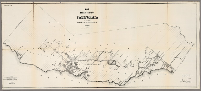
Map of the Public Surveys in California ; to Accompany Report of Surveyor Genl., 1854. P.S. Duval & Co's Steam Lith. Press. Phila. Surveyor General's Office, San Francisco, Calif., Sept. 28th, 1854, Approved John C. Hays, U.S. Sur. Genl. Cal.
List No
1073.001
Note
Eleven issues from the Annual Report, (1854,55,56,57,58,59,60,61,62, 63,64). Without color. Scale 16 miles to an inch. Relief shown by hachures. In upper left corner: Sen. Ex. No. 1. 2nd Sess. 33d Cong. Shows townships, and lands surveyed and proposed to be surveyed. Includes Explanation.
Author
[Santarem, Manuel Francisco de., Mauro, Fra]
Full Title
Mappemonde dress es en 1450, par Fra Mauro cosmographe Venetien. Par order d'Alphonse V. Roide Portugal. Publiee pour la premiere fois de la grandeur de l'original avec toutes les Legendes par Le Vicomte de Santarem, 1854. J. J. Feuquieres, lith. Schwaerzle Sculp. Pl. I.
List No
11177.001
Note
Large circular planisphere on 6 sheets, 85x107 or smaller. Title from sheet 5. Reproduced and printed for the first time at the size of the original with all the legends and notations by Viscount of Santarém in 1854. The original 1450 map was fully described and reproduced in manuscript for the first time by William Frazer in 1804, Manuscript on vellum, BL Add. MS 1126. This was deposited at the British Museum in 1807 by William Vincent, dean of Westminster. Vincent wrote a short account of this process in 1807 in his "The Commerce and Navigation of the Ancients in the Indian Ocean," 2 vols. London: Cadell and Davies, 1807, in an appendix = 2:661–79. Matthew Edney states "Santarém took his facsimile from a tracing of Frazer’s manuscript at the BM, as indicated by the placement of Eden in the lower-right corner, rather than in the lower-left where it actually sits: see: Cattaneo, Angelo. “L’Atlas del visconte de Santarém: Una storia culturale europa tra erudizione orientalismo e colonialismo,” in “A história da cartografia na obra do 2.º visconde de Santarém. Exposição cartobibliográfica, 24 de Novembro de 2006 a 10 de Fevereiro de 2007”, edited by João Carlos García, and Maria Joaquina Feijoo, 17–49. Lisbon: Biblioteca Nacional, 2006." Fra Mauro's map was also reproduced by Placido Zurla in II Mappamondo di Fra Mauro Camaldolese, 1818 in Venice ( see our copy), and later again by Santarem in his facsimile Atlas of 1849, "Atlas de Vicomte de Santarem," see lower left sheet 5. Unusual for medieval European maps, it is oriented with South at the top (Indian Ocean, top left; Mediterranean, right center) and so meticulously drawn and full of detail and legends that it has been described as a “medieval cosmography of no small extent, a conspectus of 15th century geographical knowledge cast in medieval form.” The coasts are drawn in a style recalling that of nautical charts. Includes 4 insets at each corner, numerous note boxes on the map and explanatory text at the margins. Shows place names, rivers, mountains, lakes, etc. Landmarks shown pictorially. Text and place names in Italian, publication information in French. Relief shown pictorially.
Author
[Santarem, Manuel Francisco de., Mauro, Fra]
Full Title
Mappemonde dress es en 1450, par Fra Mauro cosmographe Venetien. Par order d'Alphonse V. Roide Portugal. Publiee pour la premiere fois de la grandeur de l'original avec toutes les Legendes par Le Vicomte de Santarem, 1854. J. J. Feuquieres, lith. Schwaerzle Sculp. Pl. II.
List No
11177.002
Note
Large circular planisphere on 6 sheets, 85x107 or smaller. Title from sheet 5. Reproduced and printed for the first time at the size of the original with all the legends and notations by Viscount of Santarém in 1854. The original 1450 map was fully described and reproduced in manuscript for the first time by William Frazer in 1804, Manuscript on vellum, BL Add. MS 1126. This was deposited at the British Museum in 1807 by William Vincent, dean of Westminster. Vincent wrote a short account of this process in 1807 in his "The Commerce and Navigation of the Ancients in the Indian Ocean," 2 vols. London: Cadell and Davies, 1807, in an appendix = 2:661–79. Matthew Edney states "Santarém took his facsimile from a tracing of Frazer’s manuscript at the BM, as indicated by the placement of Eden in the lower-right corner, rather than in the lower-left where it actually sits: see: Cattaneo, Angelo. “L’Atlas del visconte de Santarém: Una storia culturale europa tra erudizione orientalismo e colonialismo,” in “A história da cartografia na obra do 2.º visconde de Santarém. Exposição cartobibliográfica, 24 de Novembro de 2006 a 10 de Fevereiro de 2007”, edited by João Carlos García, and Maria Joaquina Feijoo, 17–49. Lisbon: Biblioteca Nacional, 2006." Fra Mauro's map was also reproduced by Placido Zurla in II Mappamondo di Fra Mauro Camaldolese, 1818 in Venice ( see our copy), and later again by Santarem in his facsimile Atlas of 1849, "Atlas de Vicomte de Santarem," see lower left sheet 5. Unusual for medieval European maps, it is oriented with South at the top (Indian Ocean, top left; Mediterranean, right center) and so meticulously drawn and full of detail and legends that it has been described as a “medieval cosmography of no small extent, a conspectus of 15th century geographical knowledge cast in medieval form.” The coasts are drawn in a style recalling that of nautical charts. Includes 4 insets at each corner, numerous note boxes on the map and explanatory text at the margins. Shows place names, rivers, mountains, lakes, etc. Landmarks shown pictorially. Text and place names in Italian, publication information in French. Relief shown pictorially.
Author
[Santarem, Manuel Francisco de., Mauro, Fra]
Full Title
Mappemonde dress es en 1450, par Fra Mauro cosmographe Venetien. Par order d'Alphonse V. Roide Portugal. Publiee pour la premiere fois de la grandeur de l'original avec toutes les Legendes par Le Vicomte de Santarem, 1854. J. J. Feuquieres, lith. Schwaerzle Sculp. Pl. III.
List No
11177.003
Note
Large circular planisphere on 6 sheets, 85x107 or smaller. Title from sheet 5. Reproduced and printed for the first time at the size of the original with all the legends and notations by Viscount of Santarém in 1854. The original 1450 map was fully described and reproduced in manuscript for the first time by William Frazer in 1804, Manuscript on vellum, BL Add. MS 1126. This was deposited at the British Museum in 1807 by William Vincent, dean of Westminster. Vincent wrote a short account of this process in 1807 in his "The Commerce and Navigation of the Ancients in the Indian Ocean," 2 vols. London: Cadell and Davies, 1807, in an appendix = 2:661–79. Matthew Edney states "Santarém took his facsimile from a tracing of Frazer’s manuscript at the BM, as indicated by the placement of Eden in the lower-right corner, rather than in the lower-left where it actually sits: see: Cattaneo, Angelo. “L’Atlas del visconte de Santarém: Una storia culturale europa tra erudizione orientalismo e colonialismo,” in “A história da cartografia na obra do 2.º visconde de Santarém. Exposição cartobibliográfica, 24 de Novembro de 2006 a 10 de Fevereiro de 2007”, edited by João Carlos García, and Maria Joaquina Feijoo, 17–49. Lisbon: Biblioteca Nacional, 2006." Fra Mauro's map was also reproduced by Placido Zurla in II Mappamondo di Fra Mauro Camaldolese, 1818 in Venice ( see our copy), and later again by Santarem in his facsimile Atlas of 1849, "Atlas de Vicomte de Santarem," see lower left sheet 5. Unusual for medieval European maps, it is oriented with South at the top (Indian Ocean, top left; Mediterranean, right center) and so meticulously drawn and full of detail and legends that it has been described as a “medieval cosmography of no small extent, a conspectus of 15th century geographical knowledge cast in medieval form.” The coasts are drawn in a style recalling that of nautical charts. Includes 4 insets at each corner, numerous note boxes on the map and explanatory text at the margins. Shows place names, rivers, mountains, lakes, etc. Landmarks shown pictorially. Text and place names in Italian, publication information in French. Relief shown pictorially.
Author
[Santarem, Manuel Francisco de., Mauro, Fra]
Full Title
Mappemonde dress es en 1450, par Fra Mauro cosmographe Venetien. Par order d'Alphonse V. Roide Portugal. Publiee pour la premiere fois de la grandeur de l'original avec toutes les Legendes par Le Vicomte de Santarem, 1854. J. J. Feuquieres, lith. Schwaerzle Sculp. Pl. IV.
List No
11177.004
Note
Large circular planisphere on 6 sheets, 85x107 or smaller. Title from sheet 5. Reproduced and printed for the first time at the size of the original with all the legends and notations by Viscount of Santarém in 1854. The original 1450 map was fully described and reproduced in manuscript for the first time by William Frazer in 1804, Manuscript on vellum, BL Add. MS 1126. This was deposited at the British Museum in 1807 by William Vincent, dean of Westminster. Vincent wrote a short account of this process in 1807 in his "The Commerce and Navigation of the Ancients in the Indian Ocean," 2 vols. London: Cadell and Davies, 1807, in an appendix = 2:661–79. Matthew Edney states "Santarém took his facsimile from a tracing of Frazer’s manuscript at the BM, as indicated by the placement of Eden in the lower-right corner, rather than in the lower-left where it actually sits: see: Cattaneo, Angelo. “L’Atlas del visconte de Santarém: Una storia culturale europa tra erudizione orientalismo e colonialismo,” in “A história da cartografia na obra do 2.º visconde de Santarém. Exposição cartobibliográfica, 24 de Novembro de 2006 a 10 de Fevereiro de 2007”, edited by João Carlos García, and Maria Joaquina Feijoo, 17–49. Lisbon: Biblioteca Nacional, 2006." Fra Mauro's map was also reproduced by Placido Zurla in II Mappamondo di Fra Mauro Camaldolese, 1818 in Venice ( see our copy), and later again by Santarem in his facsimile Atlas of 1849, "Atlas de Vicomte de Santarem," see lower left sheet 5. Unusual for medieval European maps, it is oriented with South at the top (Indian Ocean, top left; Mediterranean, right center) and so meticulously drawn and full of detail and legends that it has been described as a “medieval cosmography of no small extent, a conspectus of 15th century geographical knowledge cast in medieval form.” The coasts are drawn in a style recalling that of nautical charts. Includes 4 insets at each corner, numerous note boxes on the map and explanatory text at the margins. Shows place names, rivers, mountains, lakes, etc. Landmarks shown pictorially. Text and place names in Italian, publication information in French. Relief shown pictorially.
Author
[Santarem, Manuel Francisco de., Mauro, Fra]
Full Title
(Title Page to) Mappemonde dress es en 1450, par Fra Mauro cosmographe Venetien. Par order d'Alphonse V. Roide Portugal. Publiee pour la premiere fois de la grandeur de l'original avec toutes les Legendes par Le Vicomte de Santarem, 1854. J. J. Feuquieres, lith. Schwaerzle Sculp. Pl. V.
List No
11177.005
Note
Large circular planisphere on 6 sheets, 85x107 or smaller. Title from sheet 5. Reproduced and printed for the first time at the size of the original with all the legends and notations by Viscount of Santarém in 1854. The original 1450 map was fully described and reproduced in manuscript for the first time by William Frazer in 1804, Manuscript on vellum, BL Add. MS 1126. This was deposited at the British Museum in 1807 by William Vincent, dean of Westminster. Vincent wrote a short account of this process in 1807 in his "The Commerce and Navigation of the Ancients in the Indian Ocean," 2 vols. London: Cadell and Davies, 1807, in an appendix = 2:661–79. Matthew Edney states "Santarém took his facsimile from a tracing of Frazer’s manuscript at the BM, as indicated by the placement of Eden in the lower-right corner, rather than in the lower-left where it actually sits: see: Cattaneo, Angelo. “L’Atlas del visconte de Santarém: Una storia culturale europa tra erudizione orientalismo e colonialismo,” in “A história da cartografia na obra do 2.º visconde de Santarém. Exposição cartobibliográfica, 24 de Novembro de 2006 a 10 de Fevereiro de 2007”, edited by João Carlos García, and Maria Joaquina Feijoo, 17–49. Lisbon: Biblioteca Nacional, 2006." Fra Mauro's map was also reproduced by Placido Zurla in II Mappamondo di Fra Mauro Camaldolese, 1818 in Venice ( see our copy), and later again by Santarem in his facsimile Atlas of 1849, "Atlas de Vicomte de Santarem," see lower left sheet 5. Unusual for medieval European maps, it is oriented with South at the top (Indian Ocean, top left; Mediterranean, right center) and so meticulously drawn and full of detail and legends that it has been described as a “medieval cosmography of no small extent, a conspectus of 15th century geographical knowledge cast in medieval form.” The coasts are drawn in a style recalling that of nautical charts. Includes 4 insets at each corner, numerous note boxes on the map and explanatory text at the margins. Shows place names, rivers, mountains, lakes, etc. Landmarks shown pictorially. Text and place names in Italian, publication information in French. Relief shown pictorially.
Author
[Santarem, Manuel Francisco de., Mauro, Fra]
Full Title
Mappemonde dress es en 1450, par Fra Mauro cosmographe Venetien. Par order d'Alphonse V. Roide Portugal. Publiee pour la premiere fois de la grandeur de l'original avec toutes les Legendes par Le Vicomte de Santarem, 1854. J. J. Feuquieres, lith. Schwaerzle Sculp. Pl. VI.
List No
11177.006
Note
Large circular planisphere on 6 sheets, 85x107 or smaller. Title from sheet 5. Reproduced and printed for the first time at the size of the original with all the legends and notations by Viscount of Santarém in 1854. The original 1450 map was fully described and reproduced in manuscript for the first time by William Frazer in 1804, Manuscript on vellum, BL Add. MS 1126. This was deposited at the British Museum in 1807 by William Vincent, dean of Westminster. Vincent wrote a short account of this process in 1807 in his "The Commerce and Navigation of the Ancients in the Indian Ocean," 2 vols. London: Cadell and Davies, 1807, in an appendix = 2:661–79. Matthew Edney states "Santarém took his facsimile from a tracing of Frazer’s manuscript at the BM, as indicated by the placement of Eden in the lower-right corner, rather than in the lower-left where it actually sits: see: Cattaneo, Angelo. “L’Atlas del visconte de Santarém: Una storia culturale europa tra erudizione orientalismo e colonialismo,” in “A história da cartografia na obra do 2.º visconde de Santarém. Exposição cartobibliográfica, 24 de Novembro de 2006 a 10 de Fevereiro de 2007”, edited by João Carlos García, and Maria Joaquina Feijoo, 17–49. Lisbon: Biblioteca Nacional, 2006." Fra Mauro's map was also reproduced by Placido Zurla in II Mappamondo di Fra Mauro Camaldolese, 1818 in Venice ( see our copy), and later again by Santarem in his facsimile Atlas of 1849, "Atlas de Vicomte de Santarem," see lower left sheet 5. Unusual for medieval European maps, it is oriented with South at the top (Indian Ocean, top left; Mediterranean, right center) and so meticulously drawn and full of detail and legends that it has been described as a “medieval cosmography of no small extent, a conspectus of 15th century geographical knowledge cast in medieval form.” The coasts are drawn in a style recalling that of nautical charts. Includes 4 insets at each corner, numerous note boxes on the map and explanatory text at the margins. Shows place names, rivers, mountains, lakes, etc. Landmarks shown pictorially. Text and place names in Italian, publication information in French. Relief shown pictorially.
Author
[Kiepert, Heinrich, Ritter, Carl]
Full Title
(Covers to) Atlas von Asien : zu C. Ritter's allgemeiner Erdkunde II. Abtheilung. Vierte lieferung. Entworfen und bearbeitet von Dr. H. Kiepert. Herausgegeben durch C. Ritter. Inhalt: Bl. 1 - 4. Die Euphrat-Tigris-Lander oder Armenien, Kurdistan und Mesopotamien. Bl. 5. (insets) Gegend zwischen Mosul und Amedia. (with) Umgebungen von Mosul und Nineve. (with) Ruinen von Babylon. (Profile) Hohen-Verhaltnisse des westlichen Hoch-Asiens. Bearbeitet u. gezeichnet v. H. Kiepert. Berlin bei D. Reimer. 1854. Gest. v. H. Mahlmann.
List No
11190.000
Note
5 plates, 1 lithographic map on 4 sheets and 1 profile, 48x38 or smaller with descriptive text in 4 pages placed in blue heavy paper slip case with title printed in black on beige paste down label. Map title from sheet 1, Text title: "Erlauterungen Zum IV. Heft des atlas von Asien zu C. Ritter's Erdkunde". Boundaries, geological formation and roads are color coded. Maps showing roads, rivers, major cities and towns, lakes, etc. Relief shown by hachures. Prime meridian is Greenwich. Includes explanations and insets.
Author
[Kiepert, Heinrich, Ritter, Carl]
Full Title
(Text Page to) Atlas von Asien : zu C. Ritter's allgemeiner Erdkunde II. Abtheilung. Vierte lieferung. Entworfen und bearbeitet von Dr. H. Kiepert. Herausgegeben durch C. Ritter. Inhalt: Bl. 1 - 4. Die Euphrat-Tigris-Lander oder Armenien, Kurdistan und Mesopotamien. Bl. 5. (insets) Gegend zwischen Mosul und Amedia. (with) Umgebungen von Mosul und Nineve. (with) Ruinen von Babylon. (Profile) Hohen-Verhaltnisse des westlichen Hoch-Asiens. Bearbeitet u. gezeichnet v. H. Kiepert. Berlin bei D. Reimer. 1854. Gest. v. H. Mahlmann.
List No
11190.002
Note
5 plates, 1 lithographic map on 4 sheets and 1 profile, 48x38 or smaller with descriptive text in 4 pages placed in blue heavy paper slip case with title printed in black on beige paste down label. Map title from sheet 1, Text title: "Erlauterungen Zum IV. Heft des atlas von Asien zu C. Ritter's Erdkunde". Boundaries, geological formation and roads are color coded. Maps showing roads, rivers, major cities and towns, lakes, etc. Relief shown by hachures. Prime meridian is Greenwich. Includes explanations and insets.
Author
[Kiepert, Heinrich, Ritter, Carl]
Full Title
(Text Page to) Atlas von Asien : zu C. Ritter's allgemeiner Erdkunde II. Abtheilung. Vierte lieferung. Entworfen und bearbeitet von Dr. H. Kiepert. Herausgegeben durch C. Ritter. Inhalt: Bl. 1 - 4. Die Euphrat-Tigris-Lander oder Armenien, Kurdistan und Mesopotamien. Bl. 5. (insets) Gegend zwischen Mosul und Amedia. (with) Umgebungen von Mosul und Nineve. (with) Ruinen von Babylon. (Profile) Hohen-Verhaltnisse des westlichen Hoch-Asiens. Bearbeitet u. gezeichnet v. H. Kiepert. Berlin bei D. Reimer. 1854. Gest. v. H. Mahlmann.
List No
11190.003
Note
5 plates, 1 lithographic map on 4 sheets and 1 profile, 48x38 or smaller with descriptive text in 4 pages placed in blue heavy paper slip case with title printed in black on beige paste down label. Map title from sheet 1, Text title: "Erlauterungen Zum IV. Heft des atlas von Asien zu C. Ritter's Erdkunde". Boundaries, geological formation and roads are color coded. Maps showing roads, rivers, major cities and towns, lakes, etc. Relief shown by hachures. Prime meridian is Greenwich. Includes explanations and insets.
Author
[Kiepert, Heinrich, Ritter, Carl]
Full Title
(Text Page to) Atlas von Asien : zu C. Ritter's allgemeiner Erdkunde II. Abtheilung. Vierte lieferung. Entworfen und bearbeitet von Dr. H. Kiepert. Herausgegeben durch C. Ritter. Inhalt: Bl. 1 - 4. Die Euphrat-Tigris-Lander oder Armenien, Kurdistan und Mesopotamien. Bl. 5. (insets) Gegend zwischen Mosul und Amedia. (with) Umgebungen von Mosul und Nineve. (with) Ruinen von Babylon. (Profile) Hohen-Verhaltnisse des westlichen Hoch-Asiens. Bearbeitet u. gezeichnet v. H. Kiepert. Berlin bei D. Reimer. 1854. Gest. v. H. Mahlmann.
List No
11190.004
Note
5 plates, 1 lithographic map on 4 sheets and 1 profile, 48x38 or smaller with descriptive text in 4 pages placed in blue heavy paper slip case with title printed in black on beige paste down label. Map title from sheet 1, Text title: "Erlauterungen Zum IV. Heft des atlas von Asien zu C. Ritter's Erdkunde". Boundaries, geological formation and roads are color coded. Maps showing roads, rivers, major cities and towns, lakes, etc. Relief shown by hachures. Prime meridian is Greenwich. Includes explanations and insets.
Author
[Kiepert, Heinrich, Ritter, Carl]
Full Title
(Title Page to) Die Euphrat-Tigris-Lander oder Armenien, Kurdistan und Mesopotamien. Bl. 5. Hohen-Verhaltnisse des westlichen Hoch-Asiens. Berlin, 1854. Verlag von Dietrich Reimer. (insets) Gegend zwischen Mosul und Amedia. (with) Umgebungen von Mosul und Nineve. (with) Ruinen von Babylon. Atlas von Asien : zu C. Ritter's allgemeiner Erdkunde II. Abtheilung. Vierte lieferung. Entworfen und bearbeitet von Dr. H. Kiepert. Herausgegeben durch C. Ritter. Inhalt: Bl. 1 - 4.
List No
11190.005
Note
5 plates, 1 lithographic map on 4 sheets and 1 profile, 48x38 or smaller with descriptive text in 4 pages placed in blue heavy paper slip case with title printed in black on beige paste down label. Map title from sheet 1, Text title: "Erlauterungen Zum IV. Heft des atlas von Asien zu C. Ritter's Erdkunde". Boundaries, geological formation and roads are color coded. Maps showing roads, rivers, major cities and towns, lakes, etc. Relief shown by hachures. Prime meridian is Greenwich. Includes explanations and insets.
Author
[Kiepert, Heinrich, Ritter, Carl]
Full Title
Die Euphrat-Tigris-Lander oder Armenien, Kurdistan und Mesopotamien. Bl. 5. Hohen-Verhaltnisse des westlichen Hoch-Asiens. Berlin, 1854. Verlag von Dietrich Reimer. (insets) Gegend zwischen Mosul und Amedia. (with) Umgebungen von Mosul und Nineve. (with) Ruinen von Babylon. Atlas von Asien : zu C. Ritter's allgemeiner Erdkunde II. Abtheilung. Vierte lieferung. Entworfen und bearbeitet von Dr. H. Kiepert. Herausgegeben durch C. Ritter. Inhalt: Bl. 1 - 4.
List No
11190.006
Note
5 plates, 1 lithographic map on 4 sheets and 1 profile, 48x38 or smaller with descriptive text in 4 pages placed in blue heavy paper slip case with title printed in black on beige paste down label. Map title from sheet 1, Text title: "Erlauterungen Zum IV. Heft des atlas von Asien zu C. Ritter's Erdkunde". Boundaries, geological formation and roads are color coded. Maps showing roads, rivers, major cities and towns, lakes, etc. Relief shown by hachures. Prime meridian is Greenwich. Includes explanations and insets.
Author
[Kiepert, Heinrich, Ritter, Carl]
Full Title
Die Euphrat-Tigris-Lander oder Armenien, Kurdistan und Mesopotamien. Bl. 5. Hohen-Verhaltnisse des westlichen Hoch-Asiens. Berlin, 1854. Verlag von Dietrich Reimer. (insets) Gegend zwischen Mosul und Amedia. (with) Umgebungen von Mosul und Nineve. (with) Ruinen von Babylon. Atlas von Asien : zu C. Ritter's allgemeiner Erdkunde II. Abtheilung. Vierte lieferung. Entworfen und bearbeitet von Dr. H. Kiepert. Herausgegeben durch C. Ritter. Inhalt: Bl. 1 - 4.
List No
11190.007
Note
5 plates, 1 lithographic map on 4 sheets and 1 profile, 48x38 or smaller with descriptive text in 4 pages placed in blue heavy paper slip case with title printed in black on beige paste down label. Map title from sheet 1, Text title: "Erlauterungen Zum IV. Heft des atlas von Asien zu C. Ritter's Erdkunde". Boundaries, geological formation and roads are color coded. Maps showing roads, rivers, major cities and towns, lakes, etc. Relief shown by hachures. Prime meridian is Greenwich. Includes explanations and insets.
Author
[Kiepert, Heinrich, Ritter, Carl]
Full Title
Die Euphrat-Tigris-Lander oder Armenien, Kurdistan und Mesopotamien. Bl. 5. Hohen-Verhaltnisse des westlichen Hoch-Asiens. Berlin, 1854. Verlag von Dietrich Reimer. (insets) Gegend zwischen Mosul und Amedia. (with) Umgebungen von Mosul und Nineve. (with) Ruinen von Babylon. Atlas von Asien : zu C. Ritter's allgemeiner Erdkunde II. Abtheilung. Vierte lieferung. Entworfen und bearbeitet von Dr. H. Kiepert. Herausgegeben durch C. Ritter. Inhalt: Bl. 1 - 4.
List No
11190.008
Note
5 plates, 1 lithographic map on 4 sheets and 1 profile, 48x38 or smaller with descriptive text in 4 pages placed in blue heavy paper slip case with title printed in black on beige paste down label. Map title from sheet 1, Text title: "Erlauterungen Zum IV. Heft des atlas von Asien zu C. Ritter's Erdkunde". Boundaries, geological formation and roads are color coded. Maps showing roads, rivers, major cities and towns, lakes, etc. Relief shown by hachures. Prime meridian is Greenwich. Includes explanations and insets.
Author
[Kiepert, Heinrich, Ritter, Carl]
Full Title
Hohen-Verhaltnisse des westlichen Hoch-Asiens. Bearbeitet u. gezeichnet v. H. Kiepert. Berlin bei D. Reimer. 1854. Gest. v. H. Mahlmann. Atlas von Asien : zu C. Ritter's allgemeiner Erdkunde II. Abtheilung. Vierte lieferung. Entworfen und bearbeitet von Dr. H. Kiepert. Herausgegeben durch C. Ritter. Inhalt: Bl. 1 - 4. Die Euphrat-Tigris-Lander oder Armenien, Kurdistan und Mesopotamien. Bl. 5. (insets) Gegend zwischen Mosul und Amedia. (with) Umgebungen von Mosul und Nineve. (with) Ruinen von Babylon.
List No
11190.009
Note
8 Profiles on 1 sheet. Showing comparative height profile of the highest mountains and depth of the sea.
Author
[Kiepert, Heinrich, Ritter, Carl]
Full Title
(Composite map) Atlas von Asien : zu C. Ritter's allgemeiner Erdkunde II. Abtheilung. Vierte lieferung. Entworfen und bearbeitet von Dr. H. Kiepert. Herausgegeben durch C. Ritter. Inhalt: Bl. 1 - 4. Die Euphrat-Tigris-Lander oder Armenien, Kurdistan und Mesopotamien. Bl. 5. (insets) Gegend zwischen Mosul und Amedia. (with) Umgebungen von Mosul und Nineve. (with) Ruinen von Babylon. (Profile) Hohen-Verhaltnisse des westlichen Hoch-Asiens. Bearbeitet u. gezeichnet v. H. Kiepert. Berlin bei D. Reimer. 1854. Gest. v. H. Mahlmann.
List No
11190.010
Note
5 plates, 1 lithographic map on 4 sheets and 1 profile, 48x38 or smaller with descriptive text in 4 pages placed in blue heavy paper slip case with title printed in black on beige paste down label. Map title from sheet 1, Text title: "Erlauterungen Zum IV. Heft des atlas von Asien zu C. Ritter's Erdkunde". Boundaries, geological formation and roads are color coded. Maps showing roads, rivers, major cities and towns, lakes, etc. Relief shown by hachures. Prime meridian is Greenwich. Includes explanations and insets.
|